Review

Appraisal of Empirical Studies on Land-Use and Land-Cover Changes and Their Impact on Ecosystem Services in Nepal Himalaya

1
Key Laboratory of Land Surface Pattern and Simulation, Institute of Geographic Sciences and Natural Resources Research, CAS, Beijing 100101, China
2
College of Resources and Environment, University of Chinese Academy of Sciences, Beijing 100101, China
3
Kathmandu Center for Research and Education, Chinese Academy of Sciences—Tribhuvan University, Kathmandu 44613, Nepal
*
Author to whom correspondence should be addressed.
Sustainability 2023, 15(9), 7134; https://doi.org/10.3390/su15097134
Submission received: 26 March 2023 / Revised: 18 April 2023 / Accepted: 22 April 2023 / Published: 24 April 2023

Abstract

:
The study of land-use and land-cover change (LULCC) and their impact on ecosystem services (ESs) is vital for Nepal, where the majority of people are dependent on agriculture and services related to the ecosystem. In this context, this paper aims to appraise the empirical studies on land-use and land-cover changes and their impact on ecosystem services in Nepal Himalaya. The study acquired studies from Web of Science and Google Scholar for systematic review. Altogether, 90 scientific studies, including 64 on land use and land cover and 26 on ecosystem services, published between 1986 and 2020 focusing Nepal, were assessed. The results show that there were continual changes in land-cover and land-use types in Nepal, as well as in the pace of development due to natural, anthropogenic, and policy factors. According to the national land-cover scenario, forests tended to increase, whereas agricultural land gradually decreased in recent years, with some of the available agricultural land even being abandoned. The scenario of the agricultural land in the Karnali river basin was different from those of the land in the Koshi and Gandaki basins. In the mid-twentieth century, the expansion of agricultural land and massive deforestation were observed, mainly in the Tarai region. Development works, urbanization, and the rural–urban migration led to the gradual decrease in and abandonment of the available agricultural land in recent decades. Further, this overall scenario has determined in provision of ESs. Forests have the highest value of ES, and community forests have played a vital role in their restoration. The concept of payment for ESs has greatly supported socio-economic development and ecosystem conservation. However, the formulation and implementation of effective landscape planning with suitable policies and enforcement mechanisms is essential to balance the negative impact of LULC on the sustained management of ecosystems and their associated services.

1. Introduction

An understanding of the impact of land-use and land-cover change (LULCC) and their impact on the ecosystem and its associated services is crucial, particularly in developing countries, such as Nepal, where the livelihood of more than 60% of the total population [1] is primarily dependent on agriculture and services related to the ecosystem. Land use is defined as the humans’ exploitation of land cover for the purpose of their existence [2], whereas land cover refers to the biophysical state of the Earth’s surface, the immediate sub-surface, and human modifications, such as roads and buildings [2]. Ecosystem services (ESs), which denote the benefits that humans obtain from ecosystems [3,4], are classified into supportive (e.g., primary production and nutrient cycling), provisional (e.g., marketable goods), regulatory (i.e., soil, water, and climate regulation), and cultural (e.g., aesthetic, spiritual, and recreational) services [5,6,7]. Land use and land cover (LULC) are closely interrelated with ecosystem services through the interactions between humans and their environment. These ESs are controlled by underlying ecological processes and structures [8]. Therefore, changes in the LULC can alter ES conditions across locations and times. Around one-fifth of the global population rely on subsistence livelihoods; ES is particularly essential to these populations [4]. Human populations are dependent on different types of natural resources and ecosystems, including agriculture, forestry, and water. These ecosystems provide a wide range of valuable services to human society [9]. Land-cover types have been significantly affected by human disturbances for many years [10,11], resulting in significant changes in the amount and capacity of ecosystem services [11,12].
In considering human interactions with natural environments, the study of LULCC has become a major theme in research on sustainable development [13,14], and studies on LULC are also very important for environmental management as well [15]. When humans interact with the natural environment, the environment provides many direct and indirect benefits and also protects the lives of human beings by delivering different ESs [16]. The report of the Millennium Ecosystem Assessment (MEA) has recognized 24 broad categories of ES [4]. Depending on their characteristics, landscapes can provide various ES, but are continually altered by both natural agents and human activities [17]. Furthermore, when a LULCC event occurs, it influences the ecosystem and its services either directly or indirectly [18,19]. Disruptions to the ecosystem and its services affect human well-being and health [9]. In addition to natural influences, anthropogenic factors are also major causes of environmental alterations, such as desertification [20] and the loss of biodiversity [5]. For instance, due to the anthropogenic activities, such as the extension of cropland, there was massive deforestation in southern Asian countries during the second half of the 20th century [21]. Large amounts of natural forest have been directly influenced by human activities around the world, which has caused various changes to ESs [22]. Moreover, the understanding of past trends is important in the study of present and future trends in LULCC studies [23].
In Nepal, the Land Resource Mapping Project [24] published results on national land-cover status in 1986, based on a survey conducted in 1978–79. Since then, a number of studies have conducted by different researchers on land resources. Arial photographs were the most reliable source of LULCC studies in the historical period before the introduction of satellite images [25]. Along with new economic developmental projects in the 1950s and 1960s and the program to eradicate malaria, a huge forestland in the lowland of the country was converted into the settlements and farmland [26]. This project attracted people from the upland hills and mountains due to the high production potential in the Tarai lowland [27,28,29].
Most of the recent studies on LULCC in Nepal rely on satellite-based images, which are either analyzed at national level [30,31,32] or at the level of a major basin, such as the Koshi river basin (KoRB), the Gandaki river basin (GRB), or the Karnali river basin (KaRB). In addition, some thematic areas, such as snow cover/glaciers [33,34,35,36,37,38], urban settlements, such as the Kathmandu valley [39,40], and numerous local-level studies have also been conducted, relying on different time-series satellite data. Although there are limited datasets at national level, many regional- and small-scale datasets were prepared by several researchers [41]. Previous studies carried out by several researchers indicated that there have been continual changes in land use and land cover during different time periods in Nepal [32,41,42].
Natural environments provide a wide variety of benefits, which can be used in different ways to improve of the lives of the human beings living in them [19,43]. A systematic study on the impact of LULCC on ESs is highly necessary for the formulation of effective policies for sustainable development [44]. The flow of ESs is affect by changes in land use and land cover in particular geographical areas [45]. There are many types of contribution from the ecosystem to the social, economic, and environmental well-being of human beings [46]. In the context of Nepal, studies on ESs have been conducted at the national level [47,48], basin level, such as the KoRB [49,50], GRB [45], and KaRB [51], and provincial level [48]. Some studies are carried out in thematic areas, such as forests [52,53,54,55,56], grassland [57,58], wetlands [59,60], and protected areas [61,62,63], and others focus on specific ecological regions [64,65].
Sustainable development and environmental conservation are major concerns of the present world. Therefore, detailed information on LULCC and ESs is crucial to improve the understanding of landscape dynamics and the utilization of available resources for human well-being [66]. Several studies conducted to explore the effects of LULCC on ESs from global to local levels [50,67,68,69] have shown that changes in LULC significantly reduce the availability of ESs [70,71]. However, the impact of LULC on ESs varies across different locations and time [6,8]. An appraisal of past studies can build an understanding of how the LULC and ESs are interdependent in different respects for human well-being in the Nepalese context, and how the environment and ESs are becoming sensitive due to LULCC events, from the local to the national level.
Against this backdrop, it is essential to enhance our understanding of the impact of LULC on ESs to support the current management of ecosystems and their associated services. The present study is, therefore, an assessment based on past studies whose intention is to analyze the current state of knowledge on LULCC and its impact in the management of ecosystems and their associated services.

2. Materials and Methods
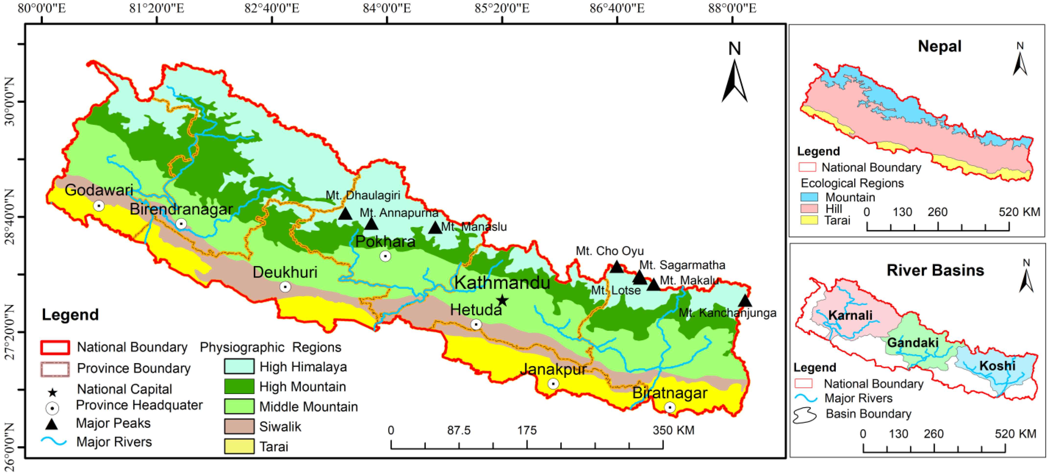
2.1. Study Area

Nepal lies in the central Himalaya, and it is a land-link country sandwiched between two nations: China, to the north, and India, to the south, east and west. The recent updated political and administrative boundary mapped by the department of surveys, government of Nepal, confirmed that the total area of the country is 147,516 km2 [72]. Nepal is preponderantly a mountainous country, and it is composed of three distinct ecological regions: the mountains, hills, and Tarai [24]. Due to its typical location, the eco-environment has been reported as highly sensitive to changes in human activities, natural disasters, and climate change [66]. There are five physiographic regions in Nepal: Tarai, Siwalik, Middle Mountain, High Mountain, and High Himalaya/Himal (Figure 1). After the amendment of new constitution in 2015, there are now 7 administrative provinces with 77 districts and 753 local bodies, in a federal system. Due to the varying physiography of Nepal, each region has different natural resources and a unique sociocultural environment. The three major basins, namely, Koshi, Gandaki, and Karnali, form an important trans-boundary. Nepal is very rich in biodiversity and ecosystems, with 12 national parks, 6 conservation areas, 1 wildlife reserve, and 1 hunting reserve [73]. Of the total population of 29,164,578, 53.61% live in Tarai, and the remainder live in Hill (40.31%) and Mountain regions (6.08%) [74]. Farming is the primary economic activity, and more than two-thirds of the total population are engaged in agricultural sector in Nepal. The agricultural sector in Nepal shares more than 27% of GDP, and the per capita income is USD 1034 [75].

2.2. Methodological Framework

A step-by-step method was adopted to conduct a review on LULC and its impact on ESs. First, peer-reviewed scientific papers on related themes available in online publications were collected using search engines such as Web of Science and Google Scholar. Second, different keywords were used, either alone or in combination, during literature search, such as ‘Land use’ OR ‘Land cover’ OR ‘Ecosystem’ OR ‘Ecosystem services’ AND ‘NEPAL’ in the title, abstract, and keywords (Figure 2).
After retrieving the related articles, review of abstracts and conclusions of the articles was conducted thoroughly to understand the importance and relevancy of each study. A PRISMA four-phase flow diagram was followed for searching, filtering, avoiding duplication, and finalizing the studies for systematic review [76] (Figure 3). Using the keywords, and applying the inclusion and exclusion criteria [77] shown in Table 1, of the total 175 identified studies, only 90 published between 1986 and 2020 were included, and their contents were reviewed. Consequently, 67 articles were excluded during analysis due to their irrelevancy for the present purpose (Figure 3).
Third, documents included in review were broadly grouped into two categories: (i) LULCC, and (ii) impact of LULCC on ESs. After conducting an extensive literature review, a proper assessment of the contents was carried out in order to elucidate the coverage of these studies by theme. First, LULCC was analyzed based on changing trends at national level, ecological regions (Mountain, Hill, and Tarai), and major river basins (Koshi, Gandaki, and Karnali).

3. Results

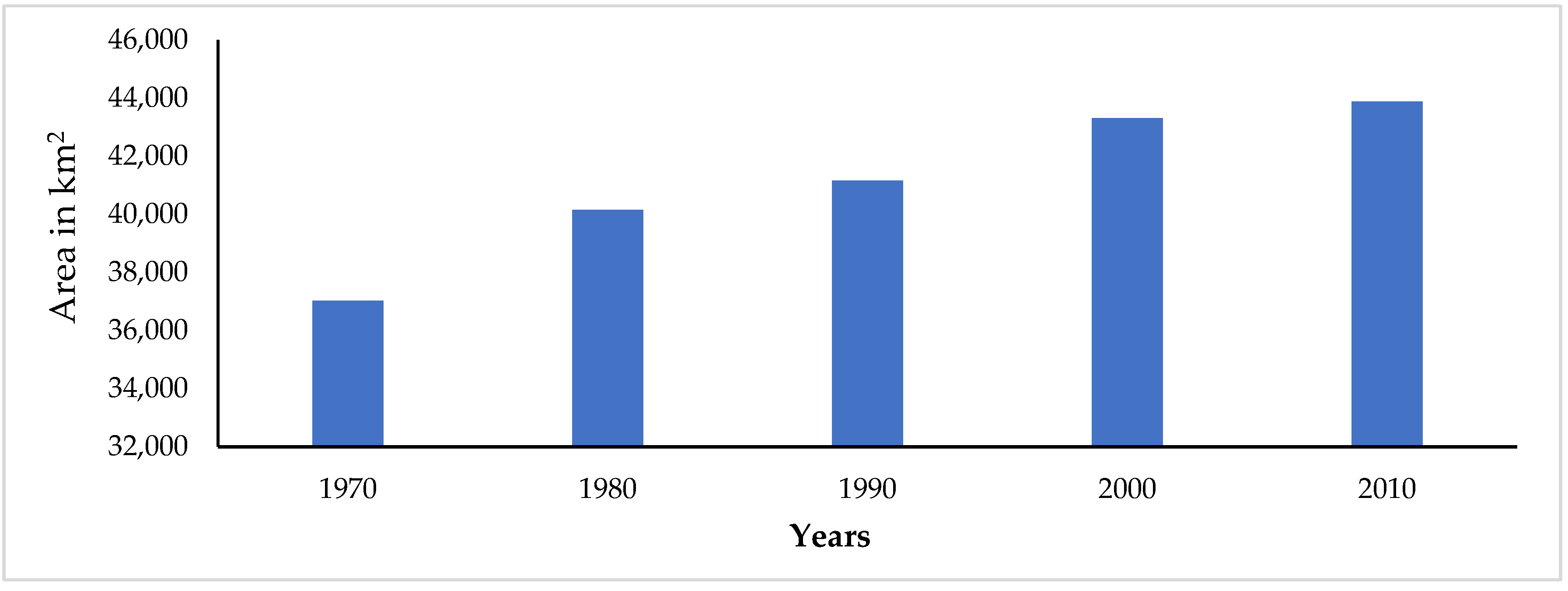
3.1. Changing Trends in LULC at National Level

Various researchers have presented different percentages of land-cover area and categorical classifications, adopting different classification methods. Before 1960, there was very limited information on LULCC at the national level, with no spatial datasets recorded [24,25]. Until the mid-nineteenth century, land-cover studies were mainly based on aerial photography and were gradually replaced by satellite images. Currently, forest remains the dominant form of land cover, followed by agricultural land and others. The areas of forest and agricultural land calculated by different studies are presented in Table 2. According to the national-level study of 2010, the major LULC was classified into eight broad categories, according to which forest cover was the dominant form of land cover, followed by cropland; combined, these forms covered nearly 70% of the total area [31] (Figure 4). Similarly, another recent study also showed that woodland (forest) is the dominant form of land cover, showing a tendency to increase, whereas agricultural land, the second form of land cover, showed a gradual decreasing trend, compared to previous studies [78].
While a recent study concluded that forest cover has expanded to 44.47% of the total land-cover area, the study was based on Google Earth Images [79]. Further, a study concluded that due to the initiation of forest management and socio-economic factors, forest coverage increased from 26.2%, in 1992, to 44.90%, in 2016 [80]. The governments’ assessment report showed that forest and other forms of woodland covered 44.77% in 2014 [81]. Forest Resource Training Centre [82] under the Ministry of Forest and Environment (MoFE) continually produced forest-cover data until 2020. There was a slight increase in forest area during the period of 1978–1985 [83]. In addition to the massive deforestation in the past, there has been a continuous increase in forest cover, in which the concept of community forest systems, with the notion of local users as the managers of forests, has played a crucial role [55,84]. In contrast, a different study showed a heavy decline in forest areas and, consequently, increased in fragmentation over a period of 84 years (1930–2014) [85]. The forest-cover analysis was performed by combining different data at various resolutions with topographical maps, which revealed a sharp decline from 76,710 km2 (52.1%), in 1930, to 39,392 km2 (26.8%), in 2014. Forest-management regimes are themselves drivers of successful forest conservation through biodiversity conservation and community management and utilization [86]. Past trends in forest-cover changes and their drivers and consequences can be also generalized to the national level from watershed levels, as revealed in a case study [87].
Table 2. Areas and percentages of forest and agricultural land in Nepal.
StudyTemporal CoverageForest Area (km2)%Agriculture Area (km2)%
LRMP (1986) [24]1978–197956,05638.0840,10527.24
Uddin et al. (2015) [31]201057,54039.0943,91029.83
Reddy et al. (2018) [85]1930–201439,39226.7641,49328.19
Li & Deng (2017) [26]1990–201560,00940.7736,90125.07
Overall, the increase in agricultural land has continued over time [30,32]. The total area of agricultural increased by 30% during the period of 1965–1985 due to the food demands of the growing population [88]. The spatiotemporal reconstruction of agricultural land during 1970–2010 shows that there was a continual increase in the area of agricultural land [30] (Figure 5). Of the total area, 25% was occupied by agricultural land in 1970, and it continued to gradually increase, covering almost 30% by the year 2000 [30]. However, in recent years, the growth of urban centers and settlement areas led to the shrinkage of agricultural land on one hand [89,90], and land abandonment on the other [91]. Natural hazards have also been observed as major reasons for land abandonment in hilly and mountainous areas [92,93,94]. A recent study based on high-resolution remote sensing noted that farmland abandonment varies by region, and found higher volumes of abandoned farmland in the hilly regions, driven mainly by socio-economic and biophysical variables [95]. The adoption of non-agricultural or secondary occupation has been also an indirect cause of these changes in agricultural land. Overall, the increase in forest land has remained constant, except the major deforestation in the past, but the area of agricultural land has gradually decreased in recent years, as a result of its conversion into built-up areas and the growth of urban centers across the country.
Nepal is one of the rapidly urbanizing countries in southern Asia [96]. Urbanization is also one of the potential factors in land-cover changes and ecosystem alterations [97]. In the current decade, the conversion of agricultural land towards urban centers is not a new phenomenon in the country [40,98]. The findings of various studies have highlighted the abandonment of cultivated land in almost all the different regions of the country. Furthermore, the findings of different studies disclosed that the biophysical characteristics of agricultural land, demographic factors, technological and economic factors, and institutional factors are the major drivers of land abandonment in the country [91]. Moreover, the study of LULCC has been prioritized as the national economy is based on agriculture. Similarly, the out migration of the population has led to land degradation from micro level [99]. Snow cover and glacial areas are further important land-cover classes, which cover almost 8.20% of the total area of the country [31]. The total glacial area is decreasing: the total area of glaciers in 1980 was 5168.30 km2; this value declined to 3902.40 km2 by 2010. However, although their total area has decreased, the number of glaciers rose from 3430, in 1980, to 3808, in 2010 [38].

3.2. Changing Trends in LULC in Ecological Regions

The degree of LULCC in each geographic area varies not only from both north to south, but also from east to west (horizontally), due to topographic and socio-economic conditions. The eastern mountainous region has higher snow-line elevation than the western and central regions [100]. Each ecological region has varied resources and different communities practicing various kinds of agricultural activities [101]. Although a large part of the land is concentrated in the Hill (68%) and Mountain (15%) ecological regions, these are less efficient in terms of agricultural production (cereal and other crops, excluding non-farming products), whereas Tarai, which has the most suitable land for potential agricultural production, has a coverage of 17% of the total area. Most of the agricultural lands are concentrated in the southern Tarai regions, whereas most of the barren and snow-covered/glacial lands are in the Mountain region [31]. Forest-cover areas are predominant in the Hill and Mountain regions [81].
The settlements in the Tarai region is the product of historical transformations, in which huge deforestation occurred due to the government’s new settlement policy after the malaria-eradication program [26]. Due to the prospect of easy access to various amenities, the migration of people from hilly areas was unprecedented in number. The highlands are less desirable for agricultural mass production due to the weaker fertility of the soil and the topography; this is one of the reasons why people migrate towards lower-lying lands, either for better agricultural prospects or in search of better opportunities in urban areas [50]. The transformation of land use was also occurred due to the migration of local people in search of better living conditions and opportunities in urban areas and through foreign labor [102,103]. Additionally, some ineffective government policies have driven LULCC from the local to the national level, particularly in terms of agricultural-land-use alteration [104,105,106].
Croplands were found to continuously increase in all the three ecological regions during the period of 1970–2010 [30]. However, since 2010, the agricultural land area in the Tarai regions has reduced due to the expansion of urban centers and infrastructural development [90]. However, there was also a decrease in forest areas due to their conversion, mostly for cultivation purposes, during the period of 1990–2010 [107]. The rapid growth of urban centers, along with the development of transportation channels, has increasingly converted agricultural land to build-up areas in the Tarai region. Some major urban centers (such as Kathmandu and Pokhara) and many emerging urban areas are located in hilly regions, which have undergone massive conversion from agricultural land to built-up areas. Further, the permanent migration from mountainous and hilly regions towards urban areas has caused some changes in the agricultural land in these regions.
Economic development has not only changed ordinary life, but also the forms and sources of income generation among the population. Even in the high mountainous areas, due to the direct or indirect effects of tourism, gradual changes in LULCC have occurred, in line with the pace of economic development [108]. Based on various studies, in the Hill and Mountain regions, the proportion of private forest cover is increasing and that of agricultural land is decreasing trend due to migration (in the form of internal and foreign labor). As a result of these migration processes, large areas of agricultural land have either been abandoned or gradually converted into other land-cover classes [109]. Most of the land abandonment is concentrated in the Hill and Mountain regions due to various socio-economic, natural, and development factors [91,110]. Elevation increases the likelihood of abandonment, as do the aspect and slope characteristics of the land [111].
Similarly, due to urbanization and the haphazard growth of small urban centers in the Tarai region, the area of agricultural land is continually reducing. The urban area occupied by Tarai region was 930.22 km2 in 2016, which represents a drastic increase, of 320%, from 221.1 km2 in 1989 [90]. The annual rate of urban growth was 12.61% during the years of 2011–2016. Furthermore, agricultural land in Tarai has been severely affected by floods [29]. The forest cover is also significantly disturbed by grazing, wild fires, landslides, and bush cutting [107]. Overall, the agricultural land is very vulnerable to the rapid changes in all the land-cover classes across the Mountain, Hill, and Tarai regions. However, farmers can still be encouraged by adopting specific agricultural-land-management policies, together with the provision of subsidies, insurance, infrastructural development, and new technologies [112].

3.3. Changing Trends in LULC in Major River Basins

There are three major cross-border river basins in the country, which are connected to the high-altitude Tibetan plateau, China, to the north, and the Indian Gangetic plain, to the south. Therefore, changes in LULCC are highly relevant to environmental changes and socio-economic development. Furthermore, efforts to understand trans-boundary landscapes are equally important when preparing conservation and development plans [113].
In the Koshi river basin (KoRB), there was a continuous change in the spatial coverage of the agricultural land over time, along with population growth [25]. The Koshi trans-boundary is distinguished by the high variation in its elevation and land-cover types [50,114]. In particular, forest and agricultural land occupy more than two-thirds of the total area of the basin [50]. There have been continual positive changes in the built-up areas, grasslands, and forests, whereas the cropland showed negative changes during 1990–2016 [50]. These changes were led by various socio-economic, natural, and policy developments in the nation. The rapid dispersal of urban centers was one of the main reasons for the decrease in the agricultural-land area [39,50]. The glacial areas decreased by 12.8% over four decades, including a decrease from 1498.9 km2, in 1998, to 1102.6 km2, in 2010 [38].
For instance, climatic changes greatly affected the vegetation cover in the higher-elevation areas in the Koshi basin trans-boundary [115]. Forests and cropland are the dominant forms of land cover on the southern slope of the Koshi trans-boundary [116]. Similarly, the decrease in forest cover and the increased in agricultural land bringing changed the value of the ESs in the Koshi basin trans-boundary [49]. Further, of the three ecological regions of the basin, the Hill and Mountain regions higher levels of farmland abandonment than the Tarai plain area [95]. A past study during the years 1978–1990, conducted in a district within the KoRB, also revealed the increased of abandoned land and decreases in the percentage of agricultural land [117]. According to one study, there are recurrent changes even at the micro level [118]. In that study, forest areas were found to be the dominant form of land cover, occupying 68% of the total in 1994, and increasing to 70% in 2014, whereas agricultural land decreased to 23% in 2014, having occupied 26% of the total area in 1994. The study showed that forests increased at the expense of agricultural land, mainly due to the migration of local populations and the establishment of community forests.
In the central part of the country, the Gandaki river basin (GRB) is another major trans-boundary between Nepal, China, and India. In the GRB, forest cover and agricultural land are the dominant forms of land cover, with the former concentrated in the mid-stream reaches and the latter in the lower- stream reaches [45]. The areas of grassland and snow/glaciers decreased during 1990–2015, whereas the areas under cropland, forests, built-up zones, and other forms of land cover increased [45]. The growth of urban centers in the middle and lower reaches of this basin is as common as in other trans-boundary river basins. The areas of forest have been converted gradually to agriculture. Similarly, barren land has expanded from snowy/glacial land and grassland in the up-stream reaches. A report on the status of glaciers revealed in the GRB that the glacial area decreased by almost 21.7% during 1980–2010 from 2125.5 km2 in 1980 to 1664.4 km2 by 2010 [38]. The abandonment of agricultural land was also driven by various socio-economic and natural factors, as in other parts of the country [92]. The conversion of agricultural land into abandoned land is as common as in other parts of the country, even in the recent years [119]. The area of agricultural land in the Aadhikhola watershed was 189.87 km2 in 1999, and decreased to 153.25 km2 by 2014, a reduction of almost 19%, whereas the vegetative area increased to 318.82 km2 in 2014, from 281.78 km2 in 1999, a gain of 13% within only 5 years [109]. In GRB, the rapid growth of urban centers at the expense of agricultural land was similar to that in the KoRB [120,121]. The urban/built-up area in the sub-metropolitan city of Pokhara occupied only 6%, whereas cultivated land represented 61% in 1977 [121]. After 33 years, the percentage of land use drastically changed; cultivated land represented only 20% and urban/built-up areas occupied around 51% of the total area. The shifting of occupations towards non-agricultural activities has increased the land abandonment [87]. A schematic diagram of the historical changes in the forest-cover area, their major drivers, and their consequences at the watershed level of the GRB [87] is presented in Figure 6.
Karnali is one of the most important basins in Nepal. It lies in the western part of the country. Forests and barren land account for the highest proportions among the various forms of land cover in the area [51]. The proportion of agricultural land is different in this area from those in the other two trans-boundary basins. The area under agricultural land is more than half of the total area of bare land, andmore than 900 km2 of snow-covered areas were converted into bare land during 2000–2017 [51]. Out of a total coverage of 1022.8 km2, around 362.8 km2 of glacier coverage was depleted over 40 years within the Karnali river basin (KaRB) [38]. The area of glacial coverage declined to 1022.8 km2 in 2010, from 1385.4 km2 in 1998. The area under forest cover and water bodies in slightly decreased in recent years. The areas under built-up zones, agriculture, shrubs, and grassland have increased. aimilar scenario characterizes the Ghodaghodi lake complex, where a 4% decrease in forest cover and a 9% decrease in agricultural land were observed during 1989–2016, whereas settlement land increased by 361% in that period [122]. Due to topographical constraints and socio-economic factors, the region is deprived of various developmental activities [123]. Due to inadequate facilities and livelihood options, people from this area have continuously migrated, which has resulted in a huge transformation of agricultural land into private forests. Overall, there are significant LULCC in the KoRB and GRB compared to the KaRB.

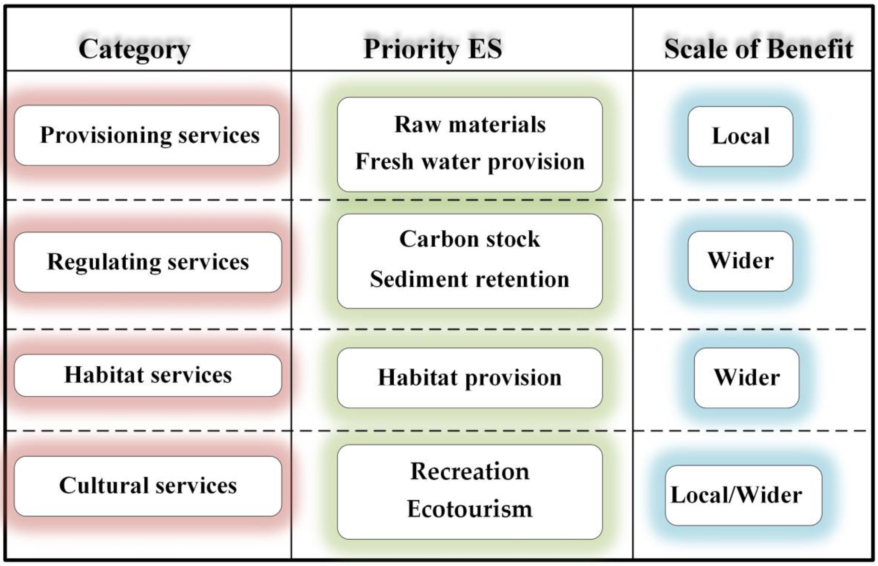
3.4. Status of Ecosystem Services
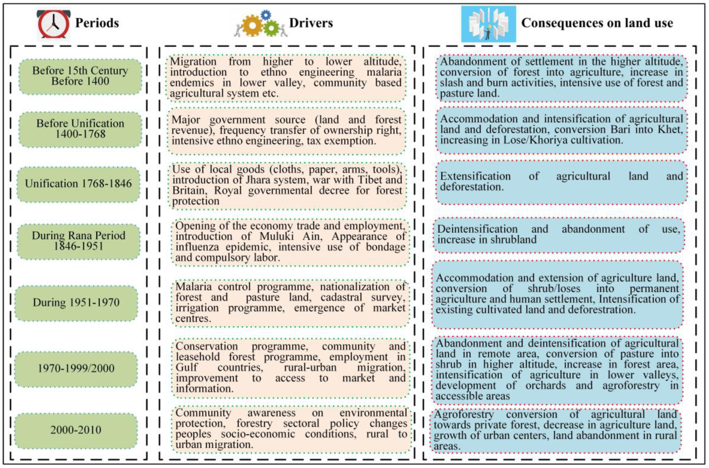
The changes in land use and land cover can affects ESs in various ways, depending on how certain services are acquireed and at which concentrations they are utilized [124]. The alterations in different LULCs can influence the flow of ESs [125]. The decline in the ecosystems and services provided by these ecosystems is notably linked to population growth, anthropogenic activities, climate change, and inadequate policies [126]. In addition to the effects of the climate on LULCC and food production [127,128], some other human-induced events also lead to land-cover changes, which are reflected in changes in ESs [129]. Changes in LULC in any proportion can affect the value and flow of ESs [45,50,51]. The kinds of ES are directly linked to the type of land cover and the the uses of available resources by the population.
The sustainability flow of ESs is very important for the well-being of humans and for maintaining biodiversity [43]. The ESs differ according to the availability of resources in a particular area. At the national level, forest cover occupies the highest proportion of all the land-cover classes [31], and has provided various ESs around the country in various forms. The protected areas in the country play a crucial role not only in environmental conservation, but also in the welfare of the local population [61,130]. Similarly, wetlands are also good sources of ESs, upon which people rely in different forms [59,60].
The value of forest ESs increased during 2000–2017, but those of cropland, grassland, and barren land decreased at the national level [48]. The value of forest ESs increased in the one of the important river basins., the GRB [45]. Similarly, in the KoRB, the value of forest ESs (carbon storage and habitat quality) also increased [50]. Forests play a vital role in the provision of different ESs in the Chure and Tarai regions, which are potential areas of agricultural productivity [131]. However, it is projected that there will be a great decrease in forest ecosystems’ value in the Koshi trans-boundary, with the greatest proportion of this decrease occurring in Nepal [49]. Deforestation, land reclamation, and rapid urbanization are the major factors in the decrease in the value of ESs [49]. Similarly, an anlysis of three major ESs (food production, carbon storage, and habitat quality) during 1996–2016 showed that carbon storage increased in the first decade and decreased in the later decades. Habitat quality remained constant overall, but food production decreased throughout the period. Most of the decreases were observed in the lower (Tarai) region [50]. The land-use changes due to urbanization and other factors, such as deforestation and land reclamation, are the major factors in the shrinkages in value of different ESs [132].
In the GRB, the changes in land cover, including increases in the area of cropland, forest, and water bodies helped to increase the value of ESs during 1990–2015 [45]. Similarly, in the KaRB, the overall ESs increased during 2000–2017. This increase was primarily due to the increase in the value of shrub/grassland, bare areas, and water bodies in the more elevated regions of the basin [51]. To determine the value systems of local inhabitants regarding environmental quality and their willingness to pay (WTP) for ESs, socio-economic factors can play a vital role [133]. Forests provide high levels of ecosystem services, from local to broader extents, and there is a need for a multi-stakeholder consultation process to assess forest-based ecosystems [64]. Anthropogenic activities are responsible for diminishing and improving ESs [52,134], so the mapping of available ESs in particular regions is crucial for the effective management of biodiversity, economic sustainability, and human well-being [135].

4. Discussion

4.1. Land-Use and Land-Cover Changes and Their Impact on Ecosystem Services

The historical land-use studies of Nepal also revealed that there have been significant alterations in LULC. Most of the past studies revealed that the changes in LULC were related to the socio-economic, demographic, and political changes in the country [136,137,138]. Driven by the administrative and political reformations in the nation, there have been continuous changes in the land-tenure system over time, which have also changed the land-use systems [27,139,140]. Despite population growth, the area of agricultural land remained stable in local-level studies, resulting from the rigid land tenure system [117].
However, the changes in certain forms of land cover have resulted in a reduction in local people’s dependency and the weakening of different services [63,132]. Moreover, the reliance of socioeconomic demands on particular environments is highly significant [141,142]. Unplanned land utilization has not only caused changes in the land cover but also created some serious environmental issues, which have become increasngly challenging in recent years [40].
Anthropogenic activities can play both positive and negative roles in the restoration of different ESs in particular areas [99]. Many studies have concluded that the area under forest cover has increased, but it is now time to evaluate how the population can benefit from the positive changes in forest cover and its sustainability in the long term [65]. The changes in land cover have exerted a positive impact on the ESs in the Phewa watershed [142]. Due to the increase in dense forest areas, different ESs, such as recreation, ecotourism, biodiversity, the retention of carbon stocks and sedimentation, the supply of raw materials, and water quality, have been improved [143]. The scale of the benefits of different ESs may extend from local to wider regions (to a larger geographical extent) (Figure 7).
The rapid changes in LULC, along with unplanned urban growth, have not only destroyed the previous patterns of land use, but also created serious environmental challenges [98,144]. The urban growth during 1978–2000 increased almost by 450%, which involved the conversion of the national capital Kathmandu from forest and agricultural land [98]. The rate of food production in the KoRB decreased due to high rates of abandonment of agricultural land in Hill and the growth of urban centers in the Tarai regions [50]. The process of urbanization has affected not only food production, but also carbon storage in the KoRB [50]. The change in land cover in the Koshi Tappu wildlife reserve exerted worse effects on different ESs during 1976–2010. As a result of the decrease in the area of forests by 16%, of swamps/marshes by 4%, and of rivers by 14%, the ESs deteriorated by 94%, 36%, and 57% respectively [132]. The population growth led to increases in the settlement area and decreases in forest cover and agricultural aresa. The consequences of anthropogenic activities have also led to the loss of biodiversity in wetland areas [122]. Generally, any range of LUCC can definitely cause changes in the different ecosystem services provided by various forms of land cover at different levels.

4.2. Future Directions and Policy Implications

Good policy implications have the best ecological and socioeconomic outcomes in particular areas [145]. We can learn from the effective policy of “Grain to Green,” in China, which create benefits not only in China, but on a global scale, in the form of carbon sequestration [146]. The policy of community management and conservation ensures sustainable and safe monitoring and social control [147]. Nepal has established various conservation polices and contributed to trans-boundary initiatives [148]. The current policy must incorporate reliable and support for local people, which are very important in terms of the conservation of ESs and sustainable land use, in order to improve the lives of local people and ensure sustainable development [140].
Payments for ESs have been initiated in Nepal as effective measures for valuing the ecosystem and improving the lives of local people while ensuring sustainable development [149]. There has been a significant inclusion of the concept of payment for ESs in different policies formulated by the national government during different periods [150]. These policies must integrate socio-economic progress and ecological conservation [53,141]. When implementing certain acts and regulations, the participation of local populations is very important, and their knowledge, attitudes, and practices should be clearly analyzed before implementing policies to make them more sustainable. There is still a need for close coordination between different policy makers, departments, and ministries to ensure the appropriate implementation of national and regional policies [140]. The monitoring of available land resources through more scientifically advanced tools and techniques is required [47]. Nepal has many major policies for the provisioning of payment for ESs; however there is still a need to increase awareness at the grassroots level. The findings by a study [151] revealed that the design of community-based payment systems must include multi-stakeholder institutions at the local level in order to ensure the faith of ecosystem managers and service users, which is necessary to guarantee their active participation in monitoring and management processes. The implementation of an effective land-use policy must rely on the best findings and suggestions from various ground-level studies adopting a bottom-up approach. This could lead to better and more sustainable uses of available resources. Since the focus on the impact of LULCC on ESs has increased, their direct and indirect relationships have been analyzed more effectively, with a more in-depth understanding of their reciprocal importance. The tiered approach to the mapping of different ESs can be implemented to ensure sustainable resource management from the national to the community level. Furthermore, in most of the studies conducted so far, 30-m-scale satellite images were used. More detailed analyses can be performed using high-resolution satellite images in future studiess/projects on the sustainable management of natural resources and adaptations of ESs from the local to the national level.

5. Conclusions

Forests and agricultural land are the major land-cover types in Nepal. The proportions of land-cover areas vary across ecological regions and land-use practices, which are dependent on various factors. The LULCC trend shows that there are continual changes among different LULC types, in line with the pace of development due to natural, anthropogenic, and policy factors. The analysis of the national land-cover situation shows that among the major land-cover classes, forest have increased, whereas agricultural land has gradually decreased in recent years due to various factors, including the abandonment of available agricultural land. Therefore, there should be significant inquiries into the regions with the highest migration rates and consequent agricultural-land abandonment, as well as relation of this phenomenon to the overall changes. The rate of agricultural land in the KaRB was found to be different from those of the KoRB and the GRB. Forests provide high rates of ESs due to their maximal coverage, and community forests play a valuable role in spreading the concept of the restoration of payment for ESs. Although payments for ESs are initiated by both government and non-government organizations, grassroots stakeholders are not fully aware of the concept. The concept of payment for ESs offers both socio-economic improvements and ecological conservation for sustainable development. This paper could be an additional asset for the study of how LULCC and the provision of ESs are interrelated, and how they can play a crucial role in the management ofnatural resources, in line with the pace of the sustainable development of a region such as Nepal. The mapping of different LULCC and ESs with high-resolution images can enhance the understanding and monitoring of natural resources across different spatio-temporal periods. However, in order to balance the negative effects of LULCC on the sustained management of ecosystems and their associated services, it is essential to design and implement effective landscape planning with enabling policies and enforcement mechanisms.

Author Contributions

Y.Z., B.P. and M.K.R. conceptualized the topic; Y.Z. acquired the funding; M.K.R. wrote the original manuscript; Y.Z., N.R.K., P.N., B.P., L.L. and R.R. contributed to the methodology, review and editing. All authors have read and agreed to the published version of the manuscript.

Funding

The Strategic Priority Research Program of the Chinese Academy of Sciences (Grant No. XDA20040201), the Second Tibetan Plateau Scientific Expedition and Research (Grant No. 2019QZKK0603), the Chinese Academy of Sciences-The World Academy of Sciences (CAS-TWAS) President’s Fellowship Programme for international PhD students, and the President’s International Fellowship Initiative for Visiting Scientist of the Chinese Academy of Sciences (Grant No. 2021VCA0005).

Data Availability Statement

Not applicable.

Acknowledgments

We are grateful to the editors and anonymous reviewers for their valuable time.

Conflicts of Interest

The authors declare no conflict of interest.

References

  1. NPC. Fifteenth Plan: Mid-Term Evaluation (2019/20–2021/22); National Planning Commission: Kathamandu, Nepal, 2022. [Google Scholar]
  2. Lambin, E.F.; Geist, H.; Rindfuss, R.R. Introduction: Local processes with global impacts. In Land-Use and Land-Cover Change: Local Processes and Global Impacts; Springer: Berlin/Heidelberg, Germany, 2006; pp. 1–8. [Google Scholar]
  3. Díaz, S.; Demissew, S.; Carabias, J.; Joly, C.; Lonsdale, M.; Ash, N.; Larigauderie, A.; Adhikari, J.R.; Arico, S.; Báldi, A. The IPBES Conceptual Framework—Connecting nature and people. Curr. Opin. Environ. Sustain. 2015, 14, 1–16. [Google Scholar] [CrossRef]
  4. MEA. Ecosystems and Human Well-Being: Synthesis; Island Press: Washington, DC, USA, 2005; p. 122. [Google Scholar]
  5. MEA. Ecosystems and Human Well-Being: Biodiversity Synthesis; World Resources Institute: Washington, DC, USA, 2005; p. 82. [Google Scholar]
  6. Costanza, R.; De Groot, R.; Sutton, P.; Van der Ploeg, S.; Anderson, S.J.; Kubiszewski, I.; Farber, S.; Turner, R.K. Changes in the global value of ecosystem services. Glob. Environ. Chang. 2014, 26, 152–158. [Google Scholar] [CrossRef]
  7. Li, Y.; Zhu, X.; Sun, X.; Wang, F. Landscape effects of environmental impact on bay-area wetlands under rapid urban expansion and development policy: A case study of Lianyungang, China. Landsc. Urban Plan. 2010, 94, 218–227. [Google Scholar] [CrossRef]
  8. De Groot, R.S.; Wilson, M.A.; Boumans, R.M. A typology for the classification, description and valuation of ecosystem functions, goods and services. Ecol. Econ. 2002, 41, 393–408. [Google Scholar] [CrossRef]
  9. MEA. Ecosystems and Human Well-Being: Health Synthesis; World Resources Institute: Washington, DC, USA, 2005; p. 50. [Google Scholar]
  10. Song, X.-P.; Hansen, M.C.; Stehman, S.V.; Potapov, P.V.; Tyukavina, A.; Vermote, E.F.; Townshend, J.R. Global land change from 1982 to 2016. Nature 2018, 560, 639–643. [Google Scholar] [CrossRef]
  11. Lambin, E.F.; Turner, B.L.; Geist, H.J.; Agbola, S.B.; Angelsen, A.; Bruce, J.W.; Coomes, O.T.; Dirzo, R.; Fischer, G.; Folke, C. The causes of land-use and land-cover change: Moving beyond the myths. Glob. Environ. Chang. 2001, 11, 261–269. [Google Scholar] [CrossRef]
  12. Cheng, S.H.; Ahlroth, S.; Onder, S.; Shyamsundar, P.; Garside, R.; Kristjanson, P.; McKinnon, M.C.; Miller, D.C. What is the evidence for the contribution of forests to poverty alleviation? A systematic map protocol. Environ. Evid. 2017, 6, 10. [Google Scholar] [CrossRef]
  13. Ramankutty, N.; Foley, J.A. Estimating historical changes in global land cover: Croplands from 1700 to 1992. Glob. Biogeochem. Cycles 1999, 13, 997–1027. [Google Scholar] [CrossRef]
  14. Turner, B.L.; Lambin, E.F.; Reenberg, A. The emergence of land change science for global environmental change and sustainability. Proc. Natl. Acad. Sci. USA 2007, 104, 20666–20671. [Google Scholar] [CrossRef]
  15. Turner, B.L.; Meyer, W.B.; Skole, D.L. Global Land-Use/Land-Cover Change: Towards an Integrated Study. Ambio 1994, 23, 91–95. [Google Scholar]
  16. Costanza, R.; d’Arge, R.; de Groot, R.; Farber, S.; Grasso, M.; Hannon, B.; Limburg, K.; Naeem, S.; O’Neill, R.V.; Paruelo, J.; et al. The value of the world’s ecosystem services and natural capital. Nature 1997, 387, 253–260. [Google Scholar] [CrossRef]
  17. Burkhard, B.; Kroll, F.; Müller, F.; Windhorst, W. Landscapes’ capacities to provide ecosystem services-a concept for land-cover based assessments. Landsc. Online 2009, 15, 1–22. [Google Scholar] [CrossRef]
  18. Quintas-Soriano, C.; Castro, A.J.; Castro, H.; Garcia-Llorente, M. Impacts of land use change on ecosystem services and implications for human well-being in Spanish drylands. Land Use Policy 2016, 54, 534–548. [Google Scholar] [CrossRef]
  19. Nelson, E.; Mendoza, G.; Regetz, J.; Polasky, S.; Tallis, H.; Cameron, D.R.; Chan, K.M.A.; Daily, G.C.; Goldstein, J.; Kareiva, P.M.; et al. Modeling multiple ecosystem services, biodiversity conservation, commodity production, and tradeoffs at landscape scales. Front. Ecol. Environ. 2009, 7, 4–11. [Google Scholar] [CrossRef]
  20. MEA. Ecosystems and Human Well-Being: Desertification Synthesis; World Resources Institute: Washington, DC, USA, 2005; p. 22. [Google Scholar]
  21. Lepers, E.; Lambin, E.F.; Janetos, A.C.; DeFries, R.; Achard, F.; Ramankutty, N.; Scholes, R.J. A synthesis of information on rapid land-cover change for the period 1981–2000. Bioscience 2005, 55, 115–124. [Google Scholar] [CrossRef]
  22. Ellis, E.C.; Ramankutty, N. Putting people in the map: Anthropogenic biomes of the world. Front. Ecol. Environ. 2008, 6, 439–447. [Google Scholar] [CrossRef]
  23. Miao, L.; Zhu, F.; He, B.; Ferrat, M.; Liu, Q.; Cao, X.; Cui, X. Synthesis of China’s land use in the past 300 years. Glob. Planet. Chang. 2013, 100, 224–233. [Google Scholar] [CrossRef]
  24. LRMP. Land Utilization Report; Land Resource Mapping Project, Kenting Earth Science Canada and Department of Topography, Government of Nepal: Kathmandu, Nepal, 1986; p. 122.
  25. Paudel, B.; Zhang, Y.L.; Li, S.C.; Liu, L.S.; Wu, X.; Khanal, N.R. Review of studies on land use and land cover change in Nepal. J. Mt. Sci. 2016, 13, 643–660. [Google Scholar] [CrossRef]
  26. Ghimire, M. Historical Land Covers Change in the Chure-Tarai Landscape in the Last Six Decades: Drivers and Environmental Consequences. In Land Cover Change and Its Eco-Environmental Responses in Nepal; Li, A., Deng, W., Zhao, W., Eds.; Springer Geography; Springer: New York, NY, USA, 2017; pp. 109–147. [Google Scholar]
  27. Sharma, S.R.; Upreti, B.R.; Müller-Böker, U. Negotiating Access to Land in Nepal. J. Contemp. Asia 2014, 44, 521–539. [Google Scholar] [CrossRef]
  28. Gurung, H.; Khanal, N. Landscape processes in the Chure range Central Nepal. Himal. Rev. 1986, 17, 1–39. [Google Scholar]
  29. WWF-Nepal. Realigining Priorities: Climate Vulnerability Assessment, Terai Arc Landscape; WWF-Nepal: Kathmandu, Nepal, 2016; p. 71. [Google Scholar]
  30. Paudel, B.; Zhang, Y.; Li, S.; Wu, X. Spatiotemporal reconstruction of agricultural land cover in Nepal from 1970 to 2010. Reg. Environ. Chang. 2017, 17, 2349–2357. [Google Scholar] [CrossRef]
  31. Uddin, K.; Shrestha, H.L.; Murthy, M.S.R.; Bajracharya, B.; Shrestha, B.; Gilani, H.; Pradhan, S.; Dangol, B. Development of 2010 national land cover database for the Nepal. J. Environ. Manag. 2015, 148, 82–90. [Google Scholar] [CrossRef] [PubMed]
  32. Paudel, B.; Zhang, Y.; Li, S.; Liu, L. Spatiotemporal changes in agricultural land cover in Nepal over the last 100 years. J. Geogr. Sci. 2018, 28, 1519–1537. [Google Scholar] [CrossRef]
  33. Kuhle, M. Reconstruction of the Ice Age glaciation in the southern slopes of Mt. Everest, Cho Oyu, Lhotse and Makalu (Himalaya) (Part 1). J. Mt. Sci. 2006, 3, 91–124. [Google Scholar] [CrossRef]
  34. Shea, J.M.; Immerzeel, W.W.; Wagnon, P.; Vincent, C.; Bajracharya, S. Modelling glacier change in the Everest region, Nepal Himalaya. Cryosphere 2015, 9, 1105–1128. [Google Scholar] [CrossRef]
  35. Maskey, S.; Uhlenbrook, S.; Ojha, S. An analysis of snow cover changes in the Himalayan region using MODIS snow products and in-situ temperature data. Clim. Chang. 2011, 108, 391–400. [Google Scholar] [CrossRef]
  36. Shrestha, M.; Wang, L.; Koike, T.; Xue, Y.; Hirabayashi, Y. Modeling the Spatial Distribution of Snow Cover in the Dudhkoshi Region of the Nepal Himalayas. J. Hydrometeorol. 2012, 13, 204–222. [Google Scholar] [CrossRef]
  37. Bajracharya, S.R.; Maharjan, S.B.; Shrestha, B. The Status of Glaciers in the Hindu Kush-Himalayan Region; International Centre for Integrated Mountain Development (ICIMOD): Kathmandu, Nepal, 2011; p. 140. [Google Scholar]
  38. Bajracharya, S.R.; Maharjan, S.B.; Shrestha, F.; Bajracharya, O.R.; Baidya, S. Glacier Status in Nepal and Decadal Change from 1980 to 2010 Based on Landsat Data; International Centre for Integrated Mountain Development (ICIMOD): Kathmandu, Nepal, 2014. [Google Scholar]
  39. Thapa, R.B.; Murayama, Y. Scenario based urban growth allocation in Kathmandu Valley, Nepal. Landsc. Urban Plan. 2012, 105, 140–148. [Google Scholar] [CrossRef]
  40. Thapa, R.B.; Murayama, Y. Examining Spatiotemporal Urbanization Patterns in Kathmandu Valley, Nepal: Remote Sensing and Spatial Metrics Approaches. Remote Sens. 2009, 1, 534–556. [Google Scholar] [CrossRef]
  41. Paudel, B.; Gao, J.; Zhang, Y.; Wu, X.; Li, S.; Yan, J. Changes in Cropland Status and Their Driving Factors in the Koshi River Basin of the Central Himalayas, Nepal. Sustainability 2016, 8, 933. [Google Scholar] [CrossRef]
  42. Gautam, A.P.; Webb, E.L.; Shivakoti, G.P.; Zoebisch, M.A. Land use dynamics and landscape change pattern in a mountain watershed in Nepal. Agric. Ecosyst. Environ. 2003, 99, 83–96. [Google Scholar] [CrossRef]
  43. Layke, C.; Mapendembe, A.; Brown, C.; Walpole, M.; Winn, J. Indicators from the global and sub-global Millennium Ecosystem Assessments: An analysis and next steps. Ecol. Indic. 2012, 17, 77–87. [Google Scholar] [CrossRef]
  44. Tolessa, T.; Senbeta, F.; Kidane, M. The impact of land use/land cover change on ecosystem services in the central highlands of Ethiopia. Ecosyst. Serv. 2017, 23, 47–54. [Google Scholar] [CrossRef]
  45. Rai, R.; Zhang, Y.; Paudel, B.; Acharya, B.K.; Basnet, L. Land Use and Land Cover Dynamics and Assessing the Ecosystem Service Values in the Trans-Boundary Gandaki River Basin, Central Himalayas. Sustainability 2018, 10, 3052. [Google Scholar] [CrossRef]
  46. Mengist, W.; Soromessa, T.; Legese, G. Ecosystem services research in mountainous regions: A systematic literature review on current knowledge and research gaps. Sci. Total Environ. 2020, 702, 134581. [Google Scholar] [CrossRef]
  47. Gilani, H.; Qamer, F.M.; Sohail, M.; Uddin, K.; Jain, A.; Ning, W. Review of Ecosystem Monitoring in Nepal and Evolving Earth Observation Technologies. In Land Cover Change and Its Eco-Environmental Responses in Nepal; Li, A., Deng, W., Zhao, W., Eds.; Springer Geography; Springer: New York, NY, USA, 2017; pp. 165–183. [Google Scholar]
  48. Baniya, B.; Tang, Q.H.; Pokhrel, Y.; Xu, X.M. Vegetation dynamics and ecosystem service values changes at national and provincial scales in Nepal from 2000 to 2017. Environ. Dev. 2019, 32, 100464. [Google Scholar] [CrossRef]
  49. Zhao, Z.; Wu, X.; Zhang, Y.; Gao, J. Assessment of changes in the value of ecosystem services in the Koshi River Basin, Central High Himalayas based on land cover changes and the CA-Markov Model. J. Resour. Ecol. 2017, 8, 67–76. [Google Scholar] [CrossRef]
  50. Rimal, B.; Sharma, R.; Kunwar, R.; Keshtkar, H.; Stork, N.E.; Rijal, S.; Rahman, S.A.; Baral, H. Effects of land use and land cover change on ecosystem services in the Koshi River Basin, Eastern Nepal. Ecosyst. Serv. 2019, 38, 100963. [Google Scholar] [CrossRef]
  51. Shrestha, B.; Ye, Q.; Khadka, N. Assessment of Ecosystem Services Value Based on Land Use and Land Cover Changes in the Transboundary Karnali River Basin, Central Himalayas. Sustainability 2019, 11, 3183. [Google Scholar] [CrossRef]
  52. Shrestha, K.B.; Maren, I.E.; Arneberg, E.; Sah, J.P.; Vetaas, O.R. Effect of anthropogenic disturbance on plant species diversity in oak forests in Nepal, Central Himalaya. Int. J. Biodivers. Sci. Ecosyst. Serv. Manag. 2013, 9, 21–29. [Google Scholar] [CrossRef]
  53. Chaudhary, S.; McGregor, A.; Houston, D.; Chettri, N. Environmental justice and ecosystem services: A disaggregated analysis of community access to forest benefits in Nepal. Ecosyst. Serv. 2018, 29, 99–115. [Google Scholar] [CrossRef]
  54. Acharya, K.P.; Dangi, R.B. Case Studies on Measuring and Assessing Forest Degradation: Forest Degradation in Nepal: Review of Data and Methods; FAO: Italy, Rome, 2009; p. 14. [Google Scholar]
  55. Acharya, K.P. Twenty-four years of community forestry in Nepal. Int. For. Rev. 2002, 4, 149–156. [Google Scholar] [CrossRef]
  56. Bijaya, G.C.; Cheng, S.; Xu, Z.; Bhandari, J.; Wang, L.; Liu, X. Community forestry and livelihood in Nepal: A review. J. Anim. Plant Sci. 2016, 26, 1–12. [Google Scholar]
  57. Dhital, D.; Prajapati, S.; Maharjan, S.R.; Koizumi, H. Soil carbon dioxide emission: Soil respiration measurement in temperate grassland, Nepal. J. Environ. Prot. 2019, 10, 289–314. [Google Scholar] [CrossRef]
  58. Bhandari, J.; Zhang, Y. Effect of altitude and soil properties on biomass and plant richness in the grasslands of Tibet, China, and Manang District, Nepal. Ecosphere 2019, 10, e02915. [Google Scholar] [CrossRef]
  59. Baral, S.; Basnyat, B.; Khanal, R.; Gauli, K. A Total Economic Valuation of Wetland Ecosystem Services: An Evidence from Jagadishpur Ramsar Site, Nepal. Sci. World J. 2016, 2016, 2605609. [Google Scholar] [CrossRef]
  60. Sharma, B.; Rasul, G.; Chettri, N. The economic value of wetland ecosystem services: Evidence from the Koshi Tappu Wildlife Reserve, Nepal. Ecosyst. Serv. 2015, 12, 84–93. [Google Scholar] [CrossRef]
  61. Yergeau, M.-E. Tourism and local welfare: A multilevel analysis in Nepal’s protected areas. World Dev. 2020, 127, 104744. [Google Scholar] [CrossRef]
  62. Bhattarai, S.; Pant, B.; Timalsina, N. Conservation without participation: Detrimental effect of escaping people’s participation in protected area management in Nepal. In Protected Areas: Policies, Management and Future Directions; Nova Science Publishers, Inc.: Hauppauge, NY, USA, 2017; pp. 83–104. [Google Scholar]
  63. Kc, B.; Kandel, P.; Adhikari, S. Economic valuation of ecosystem services in protected areas: A case study from Nepal. Banko Janakari 2013, 23, 42–50. [Google Scholar] [CrossRef]
  64. Acharya, R.P.; Maraseni, T.N.; Cockfield, G. Local users and other stakeholders’ perceptions of the identification and prioritization of ecosystem services in fragile mountains: A case study of Chure Region of Nepal. Forests 2019, 10, 421. [Google Scholar] [CrossRef]
  65. Adhikari, S.; Baral, H.; Nitschke, C.R. Identification, Prioritization and Mapping of Ecosystem Services in the Panchase Mountain Ecological Region of Western Nepal. Forests 2018, 9, 554. [Google Scholar] [CrossRef]
  66. Li, A.; Deng, W. Land Use/Cover Change and Its Eco-environmental Responses in Nepal: An Overview. In Land Cover Change and Its Eco-Environmental Responses in Nepal; Li, A., Deng, W., Zhao, W., Eds.; Springer Geography; Springer: New York, NY, USA, 2017; pp. 1–13. [Google Scholar]
  67. Li, R.-Q.; Dong, M.; Cui, J.-Y.; Zhang, L.-L.; Cui, Q.-G.; He, W.-M. Quantification of the impact of land-use changes on ecosystem services: A case study in Pingbian County, China. Environ. Monit. Assess. 2007, 128, 503–510. [Google Scholar] [CrossRef] [PubMed]
  68. Gao, J.; Li, F.; Gao, H.; Zhou, C.; Zhang, X. The impact of land-use change on water-related ecosystem services: A study of the Guishui River Basin, Beijing, China. J. Clean. Prod. 2017, 163, S148–S155. [Google Scholar] [CrossRef]
  69. Kandel, P.; Tshering, D.; Uddin, K.; Lhamtshok, T.; Aryal, K.; Karki, S.; Sharma, B.; Chettri, N. Understanding social–ecological interdependence using ecosystem services perspective in Bhutan, Eastern Himalayas. Ecosphere 2018, 9, e02121. [Google Scholar] [CrossRef]
  70. Lu, N.; Fu, B.; Jin, T.; Chang, R. Trade-off analyses of multiple ecosystem services by plantations along a precipitation gradient across Loess Plateau landscapes. Landsc. Ecol. 2014, 29, 1697–1708. [Google Scholar] [CrossRef]
  71. Han, Z.; Song, W.; Deng, X.; Xu, X. Trade-offs and synergies in ecosystem service within the three-rivers headwater region, China. Water 2017, 9, 588. [Google Scholar] [CrossRef]
  72. DoS. Political and Adminitrative Boundary of Nepal; Department of Survey, Ministry of Land management, Cooperatives and Poverty Allevation: Kathmandu, Nepal, 2020.
  73. DNPWC. Protected Areas. 2018. Available online: http://www.dnpwc.gov.np/ (accessed on 7 October 2020).
  74. CBS. National Population Priliminary Report 2078, Nepali; CBS: Kathmandu, Nepal, 2022. [Google Scholar]
  75. GoN/MoF. Economic Survey 2018–2019; Government of Nepal, Ministry of Finance: Kathmandu, Nepal, 2018.
  76. Moher, D.; Liberati, A.; Tetzlaff, J.; Altman, D.G.; The PRISMA Group. Preferred Reporting Items for Systematic Reviews and Meta-Analyses: The PRISMA Statement. PLoS Med. 2009, 6, e1000097. [Google Scholar] [CrossRef]
  77. Sud, R.; Mishra, A.; Varma, N.; Bhadwal, S. Adaptation policy and practice in densely populated glacier-fed river basins of South Asia: A systematic review. Reg. Environ. Chang. 2015, 15, 825–836. [Google Scholar] [CrossRef]
  78. Li, A.; Lei, G.; Cao, X.; Zhao, W.; Deng, W.; Koirala, H.L. Land Cover Change and Its Driving Forces in Nepal Since 1990. In Land Cover Change and Its Eco-Environmental Responses in Nepal; Li, A., Deng, W., Zhao, W., Eds.; Springer Geography; Springer: New York, NY, USA, 2017; pp. 41–65. [Google Scholar]
  79. MoFE. National Level Forests and Land Cover Analysis of Nepal Using Google Earth Images; Ministry of Forest and Environment, Government of Nepal: Kathmandu, Nepal, 2019; p. 46.
  80. Fox, J.; Saksena, S.; Hurni, K.; Van Den Hoek, J.; Smith, A.C.; Chhetri, R.; Sharma, P. Mapping and understanding changes in tree cover in Nepal: 1992 to 2016. J. Forest Livelihood. 2019, 18, 1–11. [Google Scholar]
  81. DFRS. State of Nepal’s Forest, Forest Resource Assessment (FRA) Nepal; Department of Forest Research and Survey (DFRS): Kathmandu, Nepal, 2015. [Google Scholar]
  82. FRTC. National Land Cover Monitoring System of Nepal; Forest Research and Training Centre (FRTC): Kathmandu, Nepal, 2022. [Google Scholar]
  83. Nield, R. Fuelwood and Fodder-Problems and Policy; Water and Energy Commission Secretariat: Kathmandu, Nepal, 1985; p. 44. [Google Scholar]
  84. Gautam, A.P.; Shivakoti, G.P.; Webb, E.L. A review of forest policies, institutions, and changes in the resource condition in Nepal. Int. For. Rev. 2004, 6, 136–148. [Google Scholar] [CrossRef]
  85. Reddy, C.S.; Pasha, S.V.; Satish, K.V.; Saranya, K.R.L.; Jha, C.S.; Murthy, Y. Quantifying nationwide land cover and historical changes in forests of Nepal (1930–2014): Implications on forest fragmentation. Biodivers. Conserv. 2018, 27, 91–107. [Google Scholar] [CrossRef]
  86. Brandt, J.S.; Allendorf, T.; Radeloff, V.; Brooks, J. Effects of national forest-management regimes on unprotected forests of the Himalaya. Conserv. Biol. 2017, 31, 1271–1282. [Google Scholar] [CrossRef]
  87. Khanal, N.R. Land Use and Land Cover Dynaics in Teh Himalaya: A Case Study of the Madi Watershed, Western Development Region, Nepal; Tribhuvan University: Kathmandu, Nepal, 2002. [Google Scholar]
  88. Hrabovszky, J.P.; Miyan, K. Population- growth and Land- use in Nepal “The great turnabout”. Mt. Res. Dev. 1987, 7, 264–270. [Google Scholar] [CrossRef]
  89. Rimal, B.; Sloan, S.; Keshtkar, H.; Sharma, R.; Rijal, S.; Shrestha, U.B. Patterns of Historical and Future Urban Expansion in Nepal. Remote Sens. 2020, 12, 628. [Google Scholar] [CrossRef]
  90. Rimal, B.; Zhang, L.F.; Stork, N.; Sloan, S.; Rijal, S. Urban Expansion Occurred at the Expense of Agricultural Lands in the Tarai Region of Nepal from 1989 to 2016. Sustainability 2018, 10, 1341. [Google Scholar] [CrossRef]
  91. Chaudhary, S.; Wang, Y.; Dixit, A.M.; Khanal, N.R.; Xu, P.; Fu, B.; Yan, K.; Liu, Q.; Lu, Y.; Li, M. A Synopsis of Farmland Abandonment and Its Driving Factors in Nepal. Land 2020, 9, 84. [Google Scholar] [CrossRef]
  92. Khanal, N.R.; Watanabe, T. Abandonment of agricultural land and its consequences: A case study in the sikles area, gandaki basin, Nepal Himalaya. Mt. Res. Dev. 2006, 26, 32–40. [Google Scholar] [CrossRef]
  93. Byers, A. An assessment of landscape change in the Khumbu region of Nepal using repeat photography. Mt. Res. Dev. 1987, 7, 77–81. [Google Scholar] [CrossRef]
  94. Byers, A. Contemporary human impacts on alpine ecosystems in the Sagarmatha (Mt. Everest) National Park, Khumbu, Nepal. Ann. Assoc. Am. Geogr. 2005, 95, 112–140. [Google Scholar] [CrossRef]
  95. Paudel, B.; Wu, X.; Zhang, Y.; Rai, R.; Liu, L.; Zhang, B.; Khanal, N.R.; Koirala, H.L.; Nepal, P. Farmland abandonment and its determinants in the different ecological villages of the Koshi River Basin, Central Himalayas: Synergy of high-resolution remote sensing and social surveys. Environ. Res. 2020, 188, 109711. [Google Scholar] [CrossRef]
  96. Muzzini, E.; Aparicio, G. Urban Growth and Spatial Transition in Nepal: An Initial Assessment; The World Bank: Washington, DC, USA, 2013. [Google Scholar]
  97. Guerra, C.A.; Rosa, I.M.D.; Pereira, H.M. Change versus stability: Are protected areas particularly pressured by global land cover change? Landsc. Ecol. 2019, 34, 2779–2790. [Google Scholar] [CrossRef]
  98. Haack, B.N.; Rafter, A. Urban growth analysis and modeling in the Kathmandu Valley, Nepal. Habitat Int. 2006, 30, 1056–1065. [Google Scholar] [CrossRef]
  99. Jaquet, S.; Schwilch, G.; Hartung-Hofmann, F.; Adhikari, A.; Sudmeier-Rieux, K.; Shrestha, G.; Liniger, H.P.; Kohler, T. Does outmigration lead to land degradation? Labour shortage and land management in a western Nepal watershed. Appl. Geogr. 2015, 62, 157–170. [Google Scholar] [CrossRef]
  100. Shrestha, A.; Joshi, S. Snow Cover and Glacier Change Study in Nepalese Himalaya Using Remote Sensing and Geographic Information System. J. Hydrol. Meteorol. 2009, 6, 26–36. [Google Scholar] [CrossRef]
  101. Paudel, B.; Zhang, Y.L.; Yan, J.Z.; Rai, R.J.; Li, L.H. Farmers’ perceptions of agricultural land use changes in Nepal and their major drivers. J. Environ. Manag. 2019, 235, 432–441. [Google Scholar] [CrossRef]
  102. Awasthi, K.D.; Sitaula, B.K.; Singh, B.R.; Bajacharaya, R.M. Land-use change in two nepalese watersheds: Gis and geomorphometric analysis. Land Degrad. Dev. 2002, 13, 495–513. [Google Scholar] [CrossRef]
  103. KC, B.; Race, D. Outmigration and Land-Use Change: A Case Study from the Middle Hills of Nepal. Land 2020, 9, 2. [Google Scholar] [CrossRef]
  104. KC, B.K. Internal migration in Nepal. Popul. Monogr. Nepal 2003, 2, 121–168. [Google Scholar]
  105. Rai, M.K.; Paudel, B.; Zhang, Y.; Khanal, N.R.; Nepal, P.; Koirala, H.L. Vegetable Farming and Farmers’ Livelihood: Insights from Kathmandu Valley, Nepal. Sustainability 2019, 11, 889. [Google Scholar] [CrossRef]
  106. NPC. Nature Conservation National Strategic Framework for Sustainable Development (2015–2030); Government of Nepal, National Planning Commission Singh Durbar: Kathmandu, Nepal, 2015; p. 99.
  107. DFRS. Terai Forests of Nepal; Forest Resource Assessment Nepal Project; Department of Forest Research and Survey: Kathmand, Nepal, 2014.
  108. Garrard, R.; Kohler, T.; Price, M.F.; Byers, A.C.; Sherpa, A.R.; Maharjan, G.R. Land Use and Land Cover Change in Sagarmatha National Park, a World Heritage Site in the Himalayas of Eastern Nepal. Mt. Res. Dev. 2016, 36, 299–310. [Google Scholar] [CrossRef]
  109. Chidi, C.L. Depopulation and rural land abandonment in the hills of Nepal. SSARSC Int. J. Geosci. Geoinform. 2015, 3, 1–7. [Google Scholar]
  110. Paudel, K.P.; Tamang, S.; Shrestha, K.K. Transforming land and livelihood: Analysis of agricultural land abandonment in the Mid Hills of Nepal. J. For. Livelihood 2014, 12, 11–19. [Google Scholar]
  111. Chidi, C.L. Patch Analysis of Cultivated Land Abandonment in the Hills of Western Nepal. In Land Cover Change and Its Eco-Environmental Responses in Nepal; Li, A., Deng, W., Zhao, W., Eds.; Springer Geography; Springer: Singapore, 2017; pp. 149–162. [Google Scholar]
  112. Khatiwada, S.P.; Zhang, J.; Su, Y.; Paudel, B.; Deng, W. Agricultural Land Use Intensity and Determinants in Different Agroecological Regions in Central Nepal Himalaya. In Land Cover Change and Its Eco-Environmental Responses in Nepal; Li, A., Deng, W., Zhao, W., Eds.; Springer Geography; Springer: Singapore, 2017; pp. 281–305. [Google Scholar]
  113. Kotru, R.; Rawal, R.S.; Mathur, P.K.; Chettri, N.; Chaudhari, S.A.; Uddin, K.; Murthy, M.S.R.; Singh, S. Effective management of transboundary landscapes- Geospatial applications. In ISPRS Technical Commission Viii Symposium; Dadhwal, V.K., Diwakar, P.G., Seshasai, M.V.R., Raju, P.L.N., Hakeem, A., Eds.; International Archives of the Photogrammetry Remote Sensing and Spatial Information Sciences; Copernicus Gesellschaft Mbh: Gottingen, Germany, 2014; Volume 40-48, pp. 1309–1317. [Google Scholar]
  114. Wu, X.; Gao, J.; Zhang, Y.; Liu, L.; Zhao, Z.; Paudel, B. Land Cover Status in the Koshi River Basin, Central Himalayas. J. Resour. Ecol. 2017, 8, 10–19. [Google Scholar] [CrossRef]
  115. Zhang, Y.; Gao, J.; Liu, L.; Wang, Z.; Ding, M.; Yang, X. NDVI-based vegetation changes and their responses to climate change from 1982 to 2011: A case study in the Koshi River Basin in the middle Himalayas. Glob. Planet. Chang. 2013, 108, 139–148. [Google Scholar] [CrossRef]
  116. Zhang, Y.; Wu, X.; Zheng, D. Vertical differentiation of land cover in the central Himalayas. J. Geogr. Sci. 2020, 30, 969–987. [Google Scholar] [CrossRef]
  117. Virgo, K.J.; Subba, K.J. Land-use change between 1978 and 1990 in Dhankuta-District, Koshi hills, Eastern Nepal. Mt. Res. Dev. 1994, 14, 159–170. [Google Scholar] [CrossRef]
  118. Chapagain, P.S.; Rai, M.K.; Paudel, B. Land use land cover change and its pathways in Sidin VDC, Panchthar district, Nepal. Geogr. J. Nepal 2018, 11, 77–94. [Google Scholar] [CrossRef]
  119. Rai, R.; Zhang, Y.; Paudel, B.; Khanal, N.R. Status of Farmland Abandonment and Its Determinants in the Transboundary Gandaki River Basin. Sustainability 2019, 11, 5267. [Google Scholar] [CrossRef]
  120. Rimal, B. Urban growth and land use land cover change of Pokhara sub- Metropolitan City, Nepal. J. Theor. Appl. Inf. Technol. 2011, 26, 118–129. [Google Scholar]
  121. Rimal, B. Urbanization and the decline of agricultural land in Pokhara Sub-metropolitan City, Nepal. J. Agric. Sci. 2013, 5, 54–65. [Google Scholar] [CrossRef]
  122. Lamsal, P.; Pant, K.P.; Kumar, L.; Atreya, K. Sustainable livelihoods through conservation of wetland resources: A case of economic benefits from Ghodaghodi Lake, western Nepal. Ecol. Soc. 2015, 20. Available online: http://www.jstor.org/stable/26269717 (accessed on 25 March 2023). [CrossRef]
  123. Uddin, K.; Chaudhary, S.; Chettri, N.; Kotru, R.; Murthy, M.; Chaudhary, R.P.; Ning, W.; Shrestha, S.M.; Gautam, S.K. The changing land cover and fragmenting forest on the Roof of the World: A case study in Nepal’s Kailash Sacred Landscape. Landsc. Urban Plan. 2015, 141, 1–10. [Google Scholar] [CrossRef]
  124. Fu, B.; Zhang, L.; Xu, Z.; Zhao, Y.; Wei, Y.; Skinner, D. Ecosystem services in changing land use. J. Soils Sediments 2015, 15, 833–843. [Google Scholar] [CrossRef]
  125. Metzger, M.J.; Rounsevell, M.D.A.; Acosta-Michlik, L.; Leemans, R.; Schröter, D. The vulnerability of ecosystem services to land use change. Agric. Ecosyst. Environ. 2006, 114, 69–85. [Google Scholar] [CrossRef]
  126. Hasan, S.S.; Zhen, L.; Miah, M.G.; Ahamed, T.; Samie, A. Impact of land use change on ecosystem services: A review. Environ. Dev. 2020, 34, 14. [Google Scholar] [CrossRef]
  127. Bocchiola, D.; Brunetti, L.; Soncini, A.; Polinelli, F.; Gianinetto, M. Impact of climate change on agricultural productivity and food security in the Himalayas: A case study in Nepal. Agric. Syst. 2019, 171, 113–125. [Google Scholar] [CrossRef]
  128. Bhatt, D.; Maskey, S.; Babel, M.S.; Uhlenbrook, S.; Prasad, K.C. Climate trends and impacts on crop production in the Koshi River basin of Nepal. Reg. Environ. Chang. 2014, 14, 1291–1301. [Google Scholar] [CrossRef]
  129. Grima, N.; Singh, S.J. How the end of armed conflicts influence forest cover and subsequently ecosystem services provision? An analysis of four case studies in biodiversity hotspots. Land Use Policy 2019, 81, 267–275. [Google Scholar] [CrossRef]
  130. Thapa, K. Prospect of Financing Protected Areas through Payment for Ecosystem Services in Nepal. Int. Res. J. Environ. Sci. 2015, 4, 84–91. [Google Scholar]
  131. Bhandari, P.; Mohan, K.C.; Shrestha, S.; Aryal, A.; Shrestha, U.B. Assessments of ecosystem service indicators and stakeholder’s willingness to pay for selected ecosystem services in the Chure region of Nepal. Appl. Geogr. 2016, 69, 25–34. [Google Scholar] [CrossRef]
  132. Chaudhary, S.; Chettri, N.; Uddin, K.; Khatri, T.B.; Dhakal, M.; Bajracharya, B.; Ning, W. Implications of land cover change on ecosystems services and people’s dependency: A case study from the Koshi Tappu Wildlife Reserve, Nepal. Ecol. Complex. 2016, 28, 200–211. [Google Scholar] [CrossRef]
  133. Pakhtigian, E.L.; Jeuland, M. Valuing the environmental costs of local development: Evidence from households in Western Nepal. Ecol. Econ. 2019, 158, 158–167. [Google Scholar] [CrossRef]
  134. Dhakal, B.; Kattel, R.R. Effects of global changes on ecosystems services of multiple natural resources in mountain agricultural landscapes. Sci. Total Environ. 2019, 676, 665–682. [Google Scholar] [CrossRef]
  135. Peh, K.S.-H.; Thapa, I.; Basnyat, M.; Balmford, A.; Bhattarai, G.P.; Bradbury, R.B.; Brown, C.; Butchart, S.H.; Dhakal, M.; Gurung, H. Synergies between biodiversity conservation and ecosystem service provision: Lessons on integrated ecosystem service valuation from a Himalayan protected area, Nepal. Ecosyst. Serv. 2016, 22, 359–369. [Google Scholar] [CrossRef]
  136. Gurung, H. Nepal: Consequences of migration and policy implications. Contrib. Nepal. Stud. 1988, 15, 67–94. [Google Scholar]
  137. Subedi, B.P. International migration in Nepal: Towards an analytical framework. Contrib. Nepal. Stud. 1991, 18, 83–102. [Google Scholar]
  138. Sharma, P. Urbanization and development. Popul. Monogr. Nepal 2003, 1, 375–412. [Google Scholar]
  139. Whelpton, J. A History of Nepal; Cambridge University Press: Cambridge, MA, USA, 2005. [Google Scholar]
  140. Nepal, P.; Khanal, N.R.; Zhang, Y.L.; Paudel, B.; Liu, L. Land use Policies in Nepal: An Overview. Land Degrad. Dev. 2020, 31, 2203–2212. [Google Scholar] [CrossRef]
  141. Chaudhary, S.; McGregor, A.; Houston, D.; Chettri, N. Spiritual enrichment or ecological protection? A multi-scale analysis of cultural ecosystem services at the Mai Pokhari, a Ramsar site of Nepal. Ecosyst. Serv. 2019, 39, 100972. [Google Scholar] [CrossRef]
  142. Paudyal, K.; Baral, H.; Bhandari, S.P.; Bhandari, A.; Keenan, R.J. Spatial assessment of the impact of land use and land cover change on supply of ecosystem services in Phewa watershed, Nepal. Ecosyst. Serv. 2019, 36, 100895. [Google Scholar] [CrossRef]
  143. Paudyal, K.; Baral, H.; Bhandari, S.P.; Keenan, R.J. Design considerations in supporting payments for ecosystem services from community-managed forests in Nepal. Ecosyst. Serv. 2018, 30, 61–72. [Google Scholar] [CrossRef]
  144. Haack, B.N.; Khatiwada, G. Rice and Bricks: Environmental Issues and Mapping of the Unusual Crop Rotation Pattern in the Kathmandu Valley, Nepal. Environ. Manag. 2007, 39, 774–782. [Google Scholar] [CrossRef] [PubMed]
  145. Liu, J.; Li, S.; Ouyang, Z.; Tam, C.; Chen, X. Ecological and socioeconomic effects of China’s policies for ecosystem services. Proc. Natl. Acad. Sci. USA 2008, 105, 9477–9482. [Google Scholar] [CrossRef] [PubMed]
  146. Delang, C.O.; Yuan, Z. China’s Grain for Green Program; Springer: Cham, Switzerland, 2016. [Google Scholar]
  147. Ahmad, A.; Ahmad, S.; Nabi, G.; Liu, Q.-J.; Islam, N.; Luan, X. Trends in deforestation as a response to management regimes and policy intervention in the Hindu Kush Himalaya of Pakistan. Front. Environ. Sci. 2022, 10, 125. [Google Scholar] [CrossRef]
  148. Heinen, J.T.; Shrestha, S.K. Evolving policies for conservation: An Historical Profile of the Protected Area System of Nepal. J. Environ. Plan. Manag. 2006, 49, 41–58. [Google Scholar] [CrossRef]
  149. Bhatta, L.D.; van Oort, B.E.H.; Rucevska, I.; Baral, H. Payment for ecosystem services: Possible instrument for managing ecosystem services in Nepal. Int. J. Biodivers. Sci. Ecosyst. Serv. Manag. 2014, 10, 289–299. [Google Scholar] [CrossRef]
  150. Chaudhary, S.; McGregor, A. A critical analysis of global ecosystem services (Paristhitiki sewa) discourse in Nepal. Land Use Policy 2018, 75, 364–374. [Google Scholar] [CrossRef]
  151. Bhatta, L.D.; Khadgi, A.; Rai, R.K.; Tamang, B.; Timalsina, K.; Wahid, S. Designing community-based payment scheme for ecosystem services: A case from Koshi Hills, Nepal. Environ. Dev. Sustain. 2018, 20, 1831–1848. [Google Scholar] [CrossRef]
Figure 1. Map of Nepal with physiographic and ecological regions. Source: [72].
Sustainability 15 07134 g001
Figure 2. Methodological framework.
Sustainability 15 07134 g002
Figure 3. Systematic methods used for the reviewing of literatures. Modified after [76].
Sustainability 15 07134 g003
Figure 4. Land-use–land-cover pattern of Nepal. Data source: [31].
Sustainability 15 07134 g004
Figure 5. Changes in area of agricultural land during 1970–2010. Data source: [30].
Sustainability 15 07134 g005
Figure 6. Generalized trends in forest-area changes and their drivers. Source: modified from [87].
Sustainability 15 07134 g006
Figure 7. Priority ESs identified in the Phewa watershed. Source: modified from [142,143].
Sustainability 15 07134 g007
Table 1. Inclusion and exclusion criteria.
Citeria IncludedCriteria Excluded
Research published between 1986 and 2020Research published before 1986 and after 2020
Empirical studies on land use, ecosystems, and their associated servicesModel validation and methodological refinement
Peer-reviewed articlesProceedings, editorial, and un-reviewed documents
Research relevant to NepalResearch not relevant to Nepal
Disclaimer/Publisher’s Note: The statements, opinions and data contained in all publications are solely those of the individual author(s) and contributor(s) and not of MDPI and/or the editor(s). MDPI and/or the editor(s) disclaim responsibility for any injury to people or property resulting from any ideas, methods, instructions or products referred to in the content.

