

Fostering Urban Cohesion: Exploring Morphological Adaptations in Budapest’s IX District through a Typological Survey

Abstract
1. Introduction
2. Materials and Methods
- Land Use—this subgroup examines factors related to the layout and spatial organization of blocks, as well as the constitution of the urban landscape. The assessment of these aspects directly impacts the quality, accessibility, and complexity of the public space and its spatial connections [14].
- Commerce and Service Unity—this section investigates the physical aspects of existing commercial and service units within the surveyed urban territory, emphasizing how they contribute to promoting habitable public spaces. Additionally, it analyzes how the distribution and articulation of the service network at the street level impact the fluidity and permeability of the territory [15].
- Residential—this subgroup focuses on elements related to the residential function of analyzed buildings. Given that residential use had the most significant prominence and predominance in the Ferencváros renovation process, the elements of this subgroup seek to identify how residential buildings, whether new or renovated, have adapted to the existing urban form and structured the conformation of space [16].
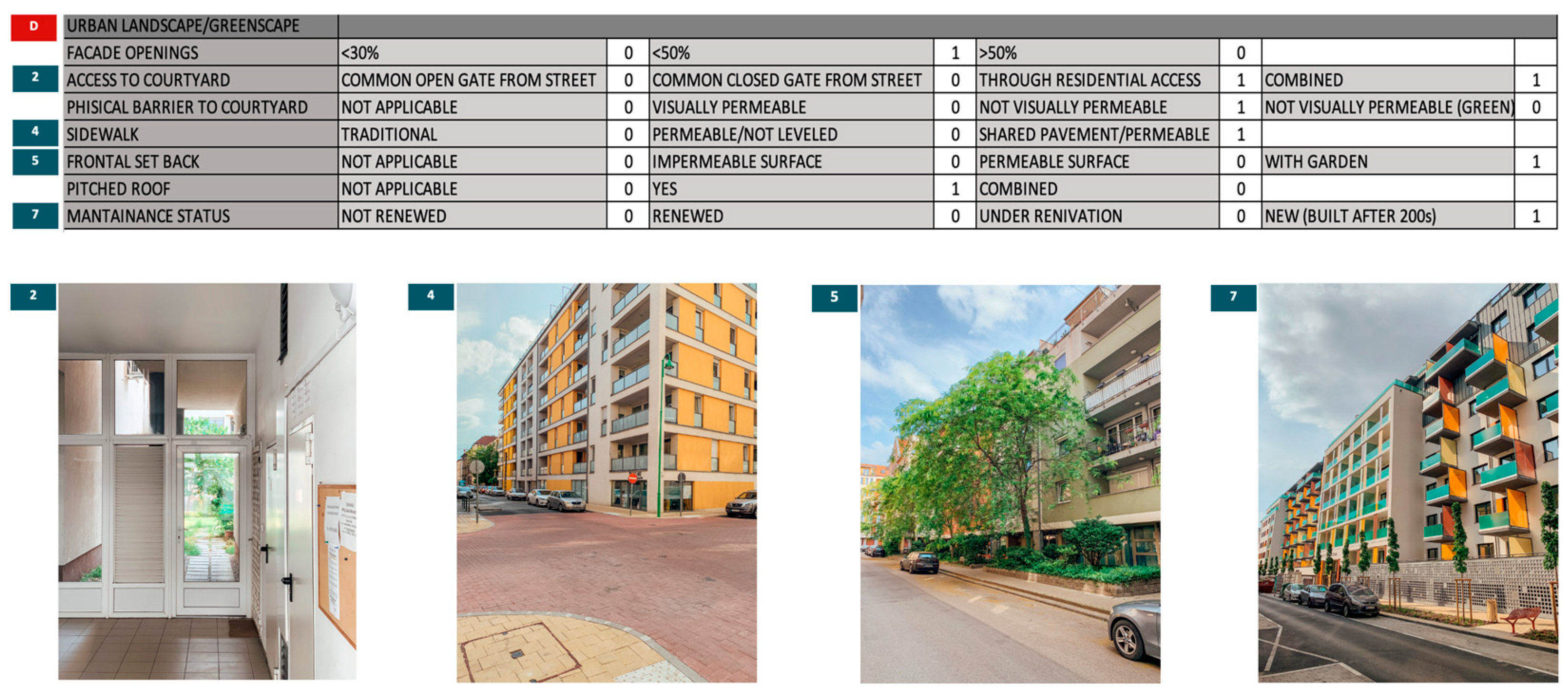
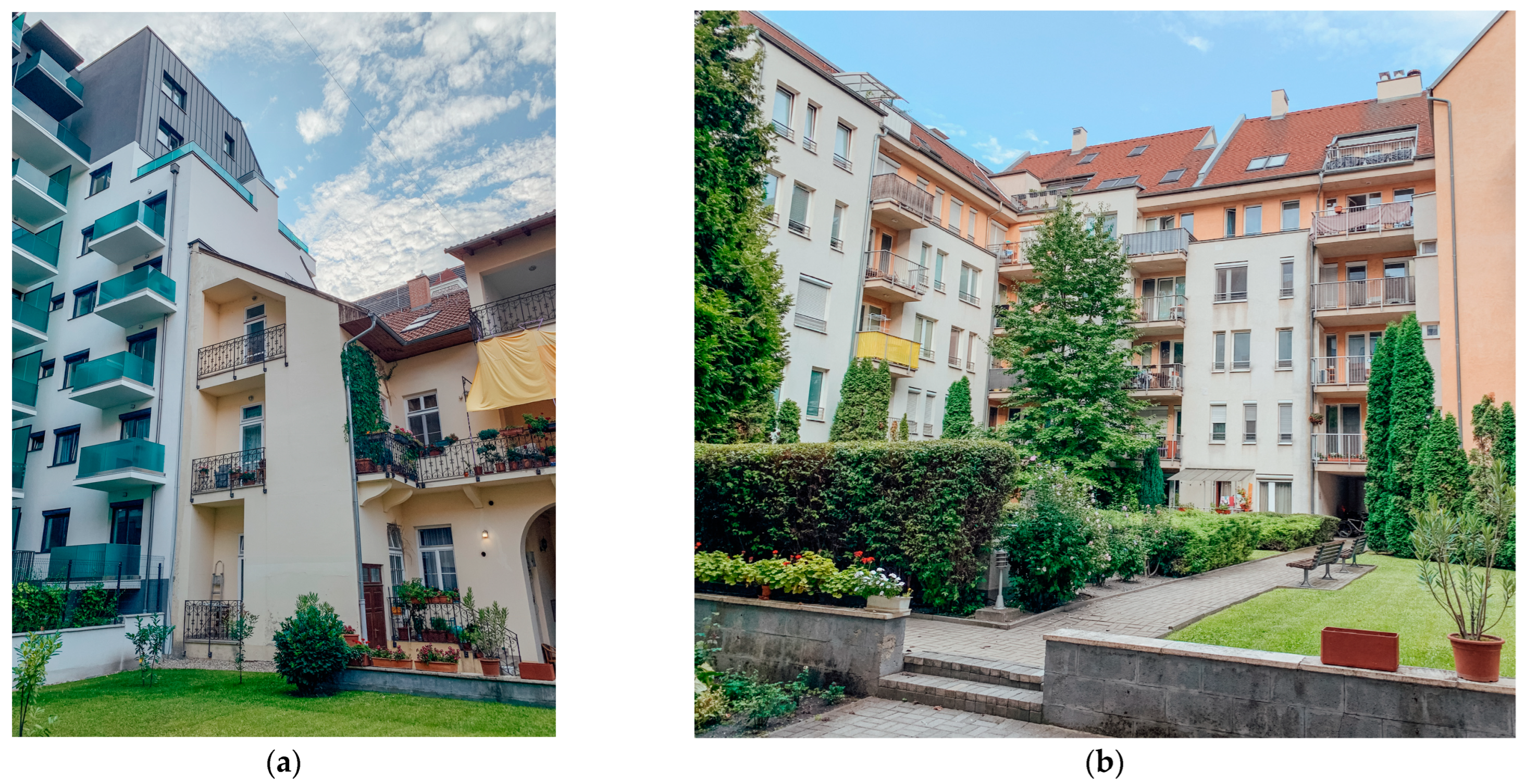
- Urban Landscape and Greenscape—this subgroup is designed to identify and characterize the constituent elements of the urban landscape. The implementation of green infrastructure was one of the tools used in the renovation of District IX, which significantly impacted not only the urban form and landscape but also the quality of public and semi-public spaces [17].
“The importance of urban morphology is argued from three perspectives—philosophical, cultural, and practical. Urban morphology makes sense of the world around us, [...] demonstrates the importance of ‘ways of seeing,’ arguing for a philosophical approach that integrates physical, social, and cultural dimensions of cities. Culturally, understanding urban morphology is a prerequisite to an awareness of urban aesthetics and the layers of meaning attached to townscapes. Through such appreciation, its study adds to the quality of life. Practically, the study of urban morphology performs a vital educational function. Through the detailed study of urban form, we learn both what not to do and how to do things better, a vital objective in achieving successful and holistic urban management. Urban morphology provides an appreciation and unique training for integrating closely related fields of practical application such as urban design, planning, architecture, and conservation.”[22]
3. Typological Analysis
Urban Elements Categorization
- T1—Newly constructed building (compliant with urban renewal requirements)
- T2—Traditional historical building (renovated)
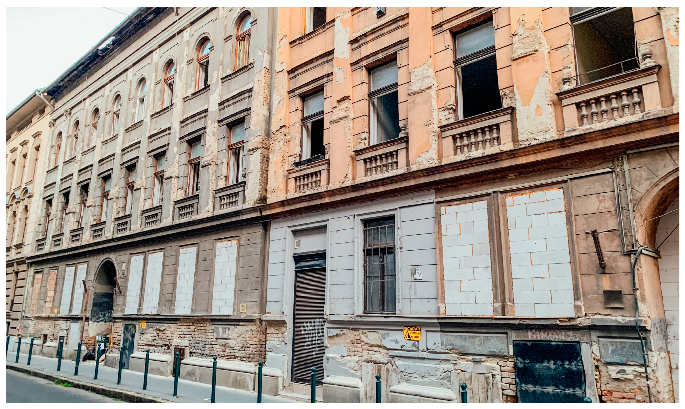
- T3—Traditional historical building (not renovated)
- T4—Large-scale institutional building
- T5—Urban Void
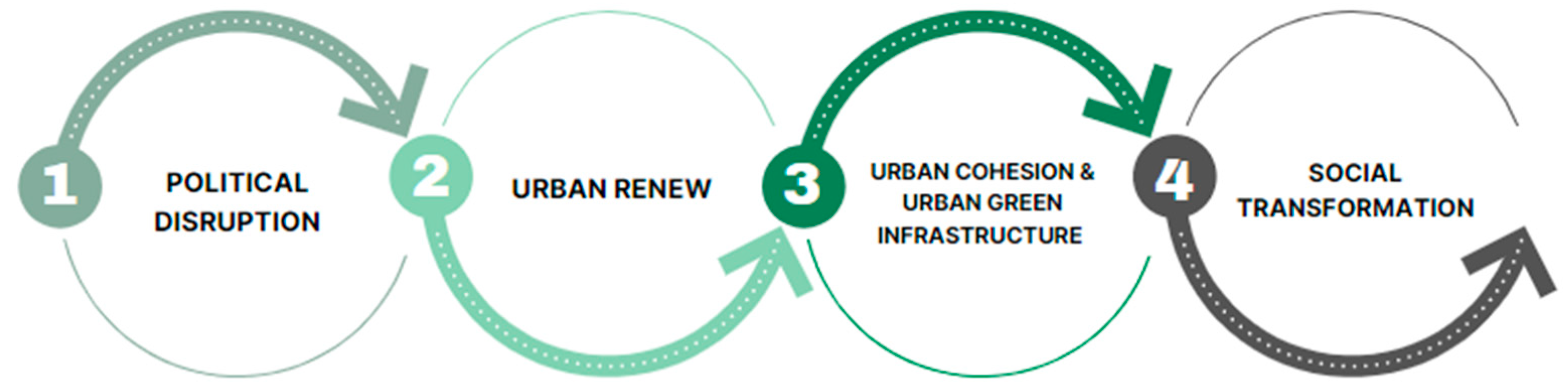
4. Conclusions
Author Contributions
Funding
Informed Consent Statement
Data Availability Statement
Acknowledgments
Conflicts of Interest
References
- Kazepov, Y. Cities of Europe: Changing Contexts, Local Arrangements, and the Challenge to Urban Cohesion; Wiley-Blackwell: Hoboken, NJ, USA, 2004. [Google Scholar] [CrossRef]
- Petrović, M.; Backović, V.; Toković, M. Rebuilding post-communist city identity: The case of Novi Pazar, Serbia. Urbani Izziv 2022, 33, 91–102. [Google Scholar] [CrossRef]
- Kovács, Z. Ghettoization or gentrification? Post-socialist scenarios for Budapest. Neth. J. Hous. Built Environ. 1998, 13, 63–81. [Google Scholar] [CrossRef]
- Wolff, M.; Wiechmann, T. Urban growth and decline: Europe’s shrinking cities in a comparative perspective 1990–2010. Eur. Urban Reg. Stud. 2018, 25, 122–139. [Google Scholar] [CrossRef]
- Tweed, C.; Sutherland, M. Built Cultural Heritage and Sustainable Urban Development. Landsc. Urban Plan. 2007, 83, 62–69. [Google Scholar] [CrossRef]
- Taherkhani, R.; Hashempour, N.; Lotfi, M. Sustainable-resilient urban revitalization framework: Residential buildings renovation in a historic district. J. Clean. Prod. 2020, 286, 124952. [Google Scholar] [CrossRef]
- Fekete, A. Diseño Urbano a través de la Arquitectura del Paisaje. El caso de estudio de Budapest. In Anales del IAA; Universidad de Buenos Aires: Buenos Aires, Argentina, 2022; Volume 52, pp. 1–18. [Google Scholar]
- Halkos, G.E.; Gkampoura, E.-C. Evaluating the effect of economic crisis on energy poverty in Europe. Renew. Sustain. Energy Rev. 2021, 144, 110981. [Google Scholar] [CrossRef]
- Liu, X.; He, J.; Xiong, K.; Liu, S.; He, B.-J. Identification of factors affecting public willingness to pay for heat mitigation and adaptation: Evidence from Guangzhou, China. Urban Clim. 2023, 48, 101405. [Google Scholar] [CrossRef]
- Khadour, N.; Fekete, A.; Sárospataki, M. The Role of the Master Plan in City Development, Latakia Master Plan in an International Context. Land 2023, 12, 1634. [Google Scholar] [CrossRef]
- Locsmándi, G. Városmegújítás a Ferencvárosban; Egedy, T., Ed.; Városrehabilitáció és Társadalom; MTA Földrajztudományi Kutató-Intézet: Budapest, Hungary, 2005; pp. 201–228. [Google Scholar]
- Eszter, B.B. Történelmi Városrészek Átalakulásának Társadalomföldrajzi Vizsgálata Budapest Belvárosában. Ph.D. Thesis, Eötvös Loránd Tudományegyetem, Budapest, Hungary, 2010. Available online: https://teo.elte.hu/minosites/ertekezes2010/berenyi_e.pdf (accessed on 10 July 2023).
- Serraos, K.; Asprogerakas, E. Typologies of Bottom-Up Planning in Southern Europe: The Case of Greek Urbanism during the Economic Crisis. In The Palgrave Handbook of Bottom-Up Urbanism; Arefi, M., Kickert, C., Eds.; Palgrave Macmillan: Cham, Switzerland, 2019. [Google Scholar] [CrossRef]
- Bertyák, Á. Urban Morphology: The Classical and Modern Research Methodologies. Period. Polytech. Archit. 2021, 52, 135–145. [Google Scholar] [CrossRef]
- Jacobs, A.; Appleyard, D. Toward an Urban Design Manifesto. J. Am. Plan. Assoc. 1987, 53, 112–120. [Google Scholar] [CrossRef]
- Hasanzadeh, K.; Kyttä, M.; Brown, G. Beyond Housing Preferences: Urban Structure and Actualisation of Residential Area Preferences. Urban Sci. 2019, 3, 21. [Google Scholar] [CrossRef]
- Childs, M.C. Creating Vibrant Public Spaces: Streetscape Design in Commercial and Historic Districts. J. Urban Des. 2010, 15, 287–289. [Google Scholar] [CrossRef]
- Locsmándi, G. Urban and housing renewal in Ferencváros, 9th district of Budapest, Hungary. 2001. Available online: https://urb.bme.hu/segedlet/angol/Locsmandi-Ferencvaros_rehabilitation.pdf (accessed on 8 August 2023).
- Fekete, A.; Hodor, K.; Dai, D. Urban Sustainability through Innovative Open Space Design. A Novel Approach to the Regeneration of Historic Open Spaces in Some Eastern European Countries and China. Earth 2021, 2, 405–423. [Google Scholar] [CrossRef]
- Roberts, P.; Sykes, H. Urban Regeneration: A Handbook; SAGE Publications Ltd.: New York, NY, USA, 2008. [Google Scholar]
- Niemi, M. Breaking from and building on the past: Helsinki and Dublin after independence. Ir. Hist. Stud. 2017, 41, 238–255. [Google Scholar] [CrossRef][Green Version]
- Barke, M. The Importance of Urban Form as an Object of Study. In Teaching Urban Morphology; Oliveira, V., Ed.; The Urban Book Series; Springer: Cham, Switzerland, 2018. [Google Scholar] [CrossRef]
- Tiryakian, E.A. Typologies. In International Encyclopedia of the Social Sciences; Macmillan: New York, NY, USA, 1968; Volume XVI, pp. 177–185. [Google Scholar]
- Khadour, N.; Al Basha, N.; Sárospataki, M.; Fekete, A. Correlation between Land Use and the Transformation of Rural Housing Model in the Coastal Region of Syria. Sustainability 2021, 13, 4357. [Google Scholar] [CrossRef]
- Gerten, C.; Boyko, D.; Fina, S. Patterns of Post-socialist Urban Development in Russia and Germany. Front. Sustain. Cities 2022, 4, 846956. [Google Scholar] [CrossRef]
- Kocsis, J.B. Patterns of urban development in Budapest after 1989. Hung. Stud. 2015, 29, 3–20. [Google Scholar] [CrossRef]
- Buda, A.; de Place Hansen, E.J.; Rieser, A.; Giancola, E.; Pracchi, V.N.; Mauri, S.; Marincioni, V.; Gori, V.; Fouseki, K.; Polo López, C.S.; et al. Conservation-Compatible Retrofit Solutions in Historic Buildings: An Integrated Approach. Sustainability 2021, 13, 2927. [Google Scholar] [CrossRef]
- Kovács, Z.; Farkas, Z.J.; Egedy, T.; Kondor, A.C.; Szabó, B.; Lennert, J.; Baka, D.; Kohán, B. Urban sprawl and land conversion in post-socialist cities: The case of metropolitan Budapest. Cities 2019, 92, 71–81. [Google Scholar] [CrossRef]
- Kovács, Z.; Wiessner, R.; Zischner, R. Urban Renewal in the Inner City of Budapest: Gentrification from a Post-socialist Perspective. Urban Stud. 2013, 50, 22–38. [Google Scholar] [CrossRef]
- Weiszer, Á.; Fekete, A. Landscape character and settlement identity. In Landscape, Garden and Man—Professional Challenges of the Present and of the Near Future, Proceedings of the 6th Conference on Horticulture and Landscape Architecture in Transylvania, Târgu Mureș, Romania, 28–29 May 2021; Benedek, K., Domokos, E., Ványolós, E., Eds.; Sapientia Hungarian University of Transylvania: Targu Mures, Romania, 2021; pp. 75–85. [Google Scholar]
- Iungman, T.; Cirach, M.; Marando, F.; Barboza, E.P.; Khomenko, S.; Masselot, P.; Quijal-Zamorano, M.; Mueller, N.; Gasparrini, A.; Urquiza, J.; et al. Cooling cities through urban green infrastructure: A health impact assessment of European cities. Lancet 2023, 401, 577–589. [Google Scholar] [CrossRef] [PubMed]
- Anguelovski, I.; Connolly, J.J.T.; Cole, H.; Garcia-Lamarca, M.; Triguero-Mas, M.; Baró, F.; Martin, N.; Conesa, D.; Shokry, G.; del Pulgar, C.P.; et al. Green gentrification in European and North American cities. Nat. Commun. 2022, 13, 3816. [Google Scholar] [CrossRef] [PubMed]
- Eplényi, A.; Fekete, A.; Kabai, R. Örökségvédelmen alapuló vidékfejlesztés a Sztánai-völgy térségében In Regionalitás, Közösségépítés, Szórványgondozás; Balogh, B., Bodó, B., Ilyés, Z., Eds.; Zsobok: Jebuc, Romania, 2007. [Google Scholar]
- Kolokotsa, D.; Lilli, K.; Gobakis, K.; Mavrigiannaki, A.; Haddad, S.; Garshasbi, S.; Mohajer, H.R.H.; Paolini, R.; Vasilakopoulou, K.; Bartesaghi, C.; et al. Analyzing the Impact of Urban Planning and Building Typologies in Urban Heat Island Mitigation. Buildings 2022, 12, 537. [Google Scholar] [CrossRef]
- Fuentes, J.M. Methodological bases for documenting and reusing vernacular farm architecture. J. Cult. Herit. 2010, 11, 119–129. [Google Scholar] [CrossRef]
- Holm, A.; Schulz, G. GentriMap: A Model for Measuring Gentrification and Displacement. In Gentrification and Resistance; Helbrecht, I., Ed.; Springer VS: Wiesbaden, Germany, 2018. [Google Scholar] [CrossRef]
- Fatiguso, F.; De Fino, M.; Cantatore, E.; Caponio, V. Resilience of Historic Built Environments: Inherent Qualities and Potential Strategies. Procedia Eng. 2017, 180, 1024–1033. [Google Scholar] [CrossRef]


Disclaimer/Publisher’s Note: The statements, opinions and data contained in all publications are solely those of the individual author(s) and contributor(s) and not of MDPI and/or the editor(s). MDPI and/or the editor(s) disclaim responsibility for any injury to people or property resulting from any ideas, methods, instructions or products referred to in the content. |
© 2023 by the authors. Licensee MDPI, Basel, Switzerland. This article is an open access article distributed under the terms and conditions of the Creative Commons Attribution (CC BY) license (https://creativecommons.org/licenses/by/4.0/).
Share and Cite
Silva Dantas, G.; Nagy, I.R.; Szövényi, A.A. Fostering Urban Cohesion: Exploring Morphological Adaptations in Budapest’s IX District through a Typological Survey. Sustainability 2023, 15, 16903. https://doi.org/10.3390/su152416903
Silva Dantas G, Nagy IR, Szövényi AA. Fostering Urban Cohesion: Exploring Morphological Adaptations in Budapest’s IX District through a Typological Survey. Sustainability. 2023; 15(24):16903. https://doi.org/10.3390/su152416903
Chicago/Turabian StyleSilva Dantas, Gabriel, Ildikó Réka Nagy, and Anna Andrea Szövényi. 2023. "Fostering Urban Cohesion: Exploring Morphological Adaptations in Budapest’s IX District through a Typological Survey" Sustainability 15, no. 24: 16903. https://doi.org/10.3390/su152416903
APA StyleSilva Dantas, G., Nagy, I. R., & Szövényi, A. A. (2023). Fostering Urban Cohesion: Exploring Morphological Adaptations in Budapest’s IX District through a Typological Survey. Sustainability, 15(24), 16903. https://doi.org/10.3390/su152416903