Abstract
Land use planning is an important task for every country in the world to ensure the sustainable use of land resources for economic and social development activities. However, many land use plans have not achieved their desired effectiveness due to a lack of consideration and evaluation of factors affecting the land use planning implementation process. This study was conducted to answer the following question: what are the main factors influencing the land use planning process in Vietnam? In this study, we use multivariate regression to identify the main factors influencing land use planning in Vietnam, including the economic factor group; institutional and policy factor group; urbanisation factor group; planning factor group; social factor group; environmental factor group; and organisational and implementation factor group. The results identified five groups of factors influencing land use planning in the Dan Phuong district through the influencing factor analysis method, including policy (Po), economy (Ec), society (So), environment (En), and others (Ot). In addition, the linear regression model obtained for land use planning in Dan Phuong district is as follows: land use planning = 0.408Po + 0.454Ec + 0.398So + 0.368En + 0.259Ot. In which the group of factors with the strongest influence was the Eco factors (β = 0.454), the second was the Po factors (β = 0.408), the third was the So factors (β = 0.398), the fourth was the En factors (β = 0.368), and lastly, there were the Ot factors (β = 0.259). The results of the analysis were used to plan land use effectively and according to local conditions. This can help managers to find solutions for the sustainable use of land resources in the future.
1. Introduction
Land is a valuable resource, understood as a specific area of the earth’s surface, including all constituent elements of the ecological environment immediately above and below that surface, such as surface climate; soil; terrain; water surface; surface sediments; groundwater and minerals; flora and fauna consortium; the state of the human settlement; and the results left by humans in the past and present [1]. Therefore, land is the most important resource in the economic and social development process of each country [2,3]. Land resources are used to meet certain human needs, with a direct impact on most economic, cultural, social, and environmental activities of each country, residential community, household, and citizen [4]. Therefore, land is the most important resource in the economic and social development process of any country [2,3]. Land resources are used to meet specific human needs and have a direct impact on most economic, cultural, social, and environmental activities in each country, including the residential community, households, and citizens [4]. Therefore, the effective management and use of land resources is a key issue for the sustainable economic and social development of most countries in the world [1,5]. One of the most important contents for effective and sustainable use of land resources is land use planning [6,7].
Land use planning is an important component of land management that contributes to meeting land needs for all socio-economic development activities. This process is closely linked to the sustainable development goals, land potential, and climate change adaptation strategies of each country [1,6]. Research on land use planning to improve land use efficiency has been conducted by many scientists around the world [8,9,10]. However, the process of land use planning is very complicated due to the influence of many different factors such as urbanisation processes [7,11], industrialisation [12,13,14]; changing social and cultural structures [15,16]; climate change; [17,18,19]; land degradation [20,21]; management policies [22,23]; and other factors. Therefore, in order to properly implement the land use planning process, it is necessary to carefully study and analyse the influencing factors based on the actual conditions of each country.
Land use planning aims to change land use in a way that is consistent with socio-economic development goals. This is a direct result of human decision making, particularly by those with land tenure rights. Many studies around the world have shown that the decision-making process to implement land use planning depends on many motivations, including physiological and psychological conditions and socio-economic conditions in each specific context. Therefore, in order to implement the land use planning process well, it is necessary to clearly understand the decision-making process and the factors that influence the decision to implement land use planning [24,25,26]. The exploratory factor analysis (EFA) method has been used by many researchers around the world in many different fields, most commonly in natural resource and environmental management research [27,28]. In the field of land management, EFA has been used to focus on aspects such as the factors affecting land use planning, the factors affecting land prices, and the factors affecting efficient land use [14,22,29,30]. This shows that EFA is a popular and effective tool for investigating factors affecting the land use planning process on a global scale.
Vietnam is a developing country with rapid urbanisation and industrialisation. Vietnam’s average economic growth rate has consistently reached 2.5–3.5%/year in the period 1986–2022 [31]. However, rapid socio-economic development has placed great pressure on land resources. The process of land use conversion is strong, especially the conversion of agricultural land to other types of land to meet the land use needs for urbanisation and industrialisation [32,33]. Furthermore, Vietnam is one of the 10 countries most affected by climate change due to rising sea levels [34]. Complex climate change has seriously affected all aspects of economic and social life, especially land resources [35,36]. In recent years, the people of Hanoi have become familiar with the impacts of climate change. The city’s environment and daily routines have been significantly disrupted by irregular weather patterns [37]. Even a small amount of rainfall can cause widespread street flooding, and prolonged heat waves can pose significant risks to the well-being of the elderly and children in hospital care. The high population density and economic vitality of megacities expose them to rapid and unsustainable development and the effects of climate change. These impacts are redefining the conventional approach to urban land use planning and are influencing the emphasis on sustainability. In Vietnam’s megacities, the environmental aspect of spatial planning has emerged as a compelling reason to harmonise well-defined adaptation strategies and responses while also incorporating mitigation policies [38,39]. The Government of Vietnam has also identified land use planning as one of the most important tools to effectively manage land resources and serve the goal of national sustainable development [40]. In Vietnam, land is owned by the whole people, and the State is the representative owner. Therefore, according to the provisions of the law, the State has the right to reclaim land when necessary for the economic and social development of the country [40]. As a result, land use planning in Vietnam is considered the centre of all planning. Based on land use planning, there is a legal basis for land allocation, land lease, and land recovery for economic and social development projects such as urban development, the construction of commercial centres, industrial development, road construction, etc. However, Vietnam’s land use planning in recent years has still shown many shortcomings due to the influence of many different factors such as political institutions, economic, social, environmental issues, and other factors [6,22]. Although there are potential risks, urban expansion continues in areas prone to natural disasters, and infrastructure development has not kept up with the pace of urban growth. Therefore, Hanoi needs more integration, assessment, and analysis of climate change impacts and other influencing factors in current urban land use planning, construction, and development [23]. This is an important basis to help managers make appropriate and timely interventions to make the most effective use of the country’s land resources. In this study, we use multivariate regression to identify the main influencing factors on land use planning in Vietnam, including the economic factor group; institutional and policy factor group; urbanisation factor group; planning factor group; social factor group; environmental factor group; and organisational and implementation factor group. Based on the results of the analysis of these influencing factors, we aim to help local authorities (study area) find appropriate solutions in publicizing land use planning to the community, supervise, control, and organise the implementation of land use planning to implement economic and social development goals sufficiently.
2. Study Area and Methodology
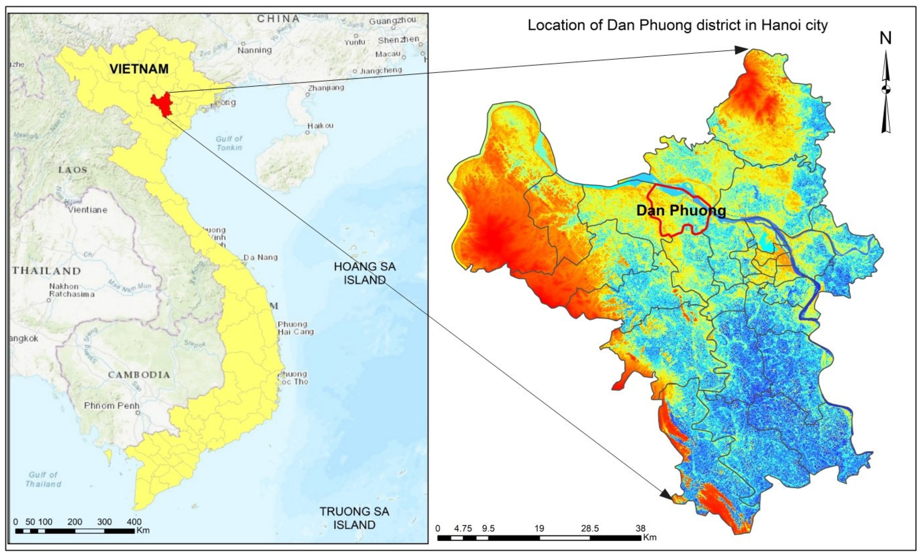
2.1. Study Area
Dan Phuong is a suburban district located 20 km northwest of Hanoi city centre (Figure 1). Dan Phuong has a flat terrain with an average altitude of 6–8 m above sea level. The total natural area of the district is 78 km2, with a population of about 182,194 people; the population density is 2335 people/km2. Dan Phuong is located in the tropical monsoon region with an average temperature of 23.1 to 23.5 °C; the average total annual rainfall ranges from 1521 to 1676 mm; and the average humidity ranges from 80 to 89% [41].
Figure 1.
Location of Dan Phuong district in Hanoi, Vietnam.
With an average growth rate of 9.63%/year in the period 2015–2020, the economy of Dan Phuong District has developed relatively stable in recent times. The economy has a strong shift towards reducing the share of Agriculture–Forestry–Fishing and increasing the share of Industry–Construction and Trade–Services. By the end of 2020, the proportion of Industry–Construction in this district accounted for 48.98%; Trade–Services accounted for 45.14%; and the proportion of Agriculture–Forestry–Fishing accounted for only 5.88%. The district’s average income/person reached 61.2 million/person/year (USD 2508.7), an increase of 2.1 times compared to 2015 [41]. However, with economic development, the demand for land to build infrastructure for socio-economic development, welfare projects for social security, and housing for people has increased. Meanwhile, the district’s land resources are limited. This poses many complex problems and puts increasing pressure on the county’s land resources. This leads to the need for proper and effective land use planning to reduce negative impacts on the ecological environment and promote local economic development. Although a specific land use plan for the period 2011–2020 has been drawn up, many shortcomings still exist in the implementation of this plan. For this reason, Dan Phuong is an ideal research site to analyse the factors influencing the land use planning process for the sustainable use of land resources in Vietnam.
2.2. Methodology
2.2.1. Secondary Data Collection
To evaluate the results and impacts of land use planning, 10 years of land data covering two periods, 2011–2015 and 2016–2020, were collected from the Department of Natural Resources and Environment of Dan Phuong District. The mainland data included the total land area, land area by purpose of use, the agricultural land area reclaimed and converted to other purposes, the list of households whose agricultural land was reclaimed for land use planning, and other relevant data for the period 2011 to 2020.
2.2.2. Questionnaire Survey
In this study, 100 people using land in the planning area conducted a questionnaire survey to determine the factors influencing the land use planning process in Dan Phuong District. This number of questionnaires meets the sample size requirements for exploratory factor analysis (EFA) [42]. Respondents were randomly selected from the list of households whose agricultural land was confiscated due to land use planning for the implementation of urban development projects, residential areas, commercial areas, industrial areas, etc., in Dan Phuong district in the period 2011–2020.
In the survey questionnaire, we used a Likert scale from 1 to 5 to construct questions that could measure the level of influence that factors have in the land use planning process. Specifically, 1 = strongly disagree; 2 = disagree; 3 = neutral (confused); 4 = agree; and 5 = strongly agree [43]. Respondents could only select one option for each question. The questionnaire was divided into 3 parts. Part 1 contained general information about the households surveyed, such as the name, age, address, occupation, qualifications, and gender of the occupants. Part 2 addressed information on the respondents’ awareness of land use planning, including information on their level of interest in land use planning; the procedures for implementing land use planning; an evaluation of the results of implementing land use planning; and the provision of propaganda and information related to local land use planning. Part 3 concerned information related to groups of factors influencing the process of land use planning implementation, including 5 main groups of factors, as described in detail in Table 1.
Table 1.
Factors affecting land use planning in Dan Phuong district.
The reliability of this scale was tested using Cronbach’s alpha coefficient and total correlation coefficient (Corrected Item–Total Correlation). The data were considered reliable if Cronbach’s alpha coefficient was in the range of 0.6 to 0.95 [44] and the total correlation coefficient of the variables was above 0.3 [45].
2.2.3. Exploratory Factor Analysis—EFA
Exploratory factors: In Vietnam, many studies have shown that there are many different factors affecting land use planning [6,22,36]. Among them, 8 main factors can be listed, including: (i) resettlement for people whose land is recovered; (ii) survey and data collection; (iii) climate and weather; (iv) vocational training and employment for people whose land is recovered; (v) the ability to raise compensation capital; (vi) the location of the land recovery area; (vii) planning objectives; and (viii) market and local development needs. In this study, based on consultation with the land management experts of Dan Phuong District, an analysis of the research results on land use planning in practice in Vietnam and the process of implementing land use planning in Dan Phuong District was conducted, and we inherited some factors and added some new factors to synthesise the 5 independent variables, including (1) policy mechanism (Po); (2) economy (Ec); (3) society (So); (4) environment (En); and (5) other (Ot). Each independent variable was divided into three observed variables, as described in detail in Table 1.
Exploratory factor analysis—EFA: EFA aims to group factors with similarities through extraction (principal component) and varimax rotation to increase the explanatory power of these factors. Prerequisites for EFA analysis include KMO (Kaiser–Meyer–OlKIN), and the suitability coefficient was in the range of 0.5 to 1.0; its loading factor on another factor was less than 0.35 or the distance between 2-factor loadings of the same variable on 2 different factors was greater than 0.3. According to Hair et al. (1998) [44], a loading factor > 0.55 should be chosen when the sample size is around 100. In addition, the scale is only accepted if the total variance explained is >50%; Barlett’s coefficient with a significance level < 0.05 was used to ensure that the factors correlated with each other; the Eigenvalue coefficient had a value ≥ 1 to ensure that these groups of factors were different.
Linear regression analysis: this study uses multivariate linear regression functions to examine the relationship between factors that affect the results of the implementation of land use planning and to test the compatibility between factors (independent variables) and the dependent variable in the research model according to the following formula:
Yi = βo + β1X1 + β2X2 + β3X3 + β4X4+ β5X5 + Ei
Here,
+ Yi is the dependent variable representing land use planning.
+ X1; X2, X3; X4; and X5 are independent variables representing the policy, economic, social, environmental, and other factors affecting land use planning, respectively.
+ β is a constant (the value of Y when all values of X = 0).
+ β1, β2, β3, β4, and β5 are the regression coefficients of each factor X (independent variable) to the dependent variable Y, respectively.
+ Ei is the standard error.
3. Results
3.1. The Implementation of Land Use Planning in Dan Phuong District for the Period 2011–2020
The results of the implementation of land use planning in Dan Phuong district for the period 2011–2020 are presented in Table 2:
Table 2.
Results of implementing land use planning in the period 2011–2020.
- Agricultural land: the planned target was to reduce agricultural land to 2561.05 ha. In fact, at the end of the planning period (30 December 2020), 3652.67 ha remained. This means that there were still 1091.62 ha of agricultural land that had not been converted to non-agricultural land according to the proposed plan.
- Non-agricultural land: the planned target was increased to 4944.64 ha. In fact, at the end of the planning period, the area of non-agricultural land was only 3424.09 ha, which was 1520.55 ha less than the plan to serve the purpose of economic and social development.
- Unused land: the planned target was to reduce this area to 229.79 ha, but by the end of 2020, this area was still 706.05 ha, which meant that 476.26 ha were not used according to the proposed plan.
The lack of the proper implementation of land use planning led to a stagnation in the implementation of works and projects in the Dan Phuong district from 2011 to 2020. Specifically, only 213 projects with a total conversion area of 498.44 ha were implemented during this period, reaching only 36.05% of the total area approved for conversion according to the proposed plan of 1382.29 ha.
3.2. Results of Exploratory Factor Analysis and Multivariate Linear Regression Model
3.2.1. Cronbach’s Alpha Reliability Test Results
The results of testing the scale reliability of the independent variables in this study are presented in the table (Table 3).
Table 3.
Results of testing the reliability of the independent variables scale.
Table 3 shows that the independent variables all have Cronbach’s alpha coefficients ranging from 0.6 to 0.95 and overall variable correlation coefficients greater than 0.3. This proves that the data are reliable for the EFA analysis process [44,46].
3.2.2. Exploratory Factor Analysis Results
The results of the KMO analysis and Bartlett’s test show that the factor loading coefficients were all greater than 0.3 (Table 4). Thus, the factors selected in this study were appropriate and used for the multivariate regression model to analyse the factors affecting land use planning in the Dan Phuong district.
Table 4.
Results of the KMO test and Bartlett’s test.
Table 4 shows that the KMO value of 0.769 was between 0.75 and 1.0. This means that the proposed factors were suitable for carrying out the EFA analysis. In addition, the results of Barlett’s test with a significance level of 0.000 met the condition (sig. < 0.05) that ensured that the proposed factors were correlated with each other overall.
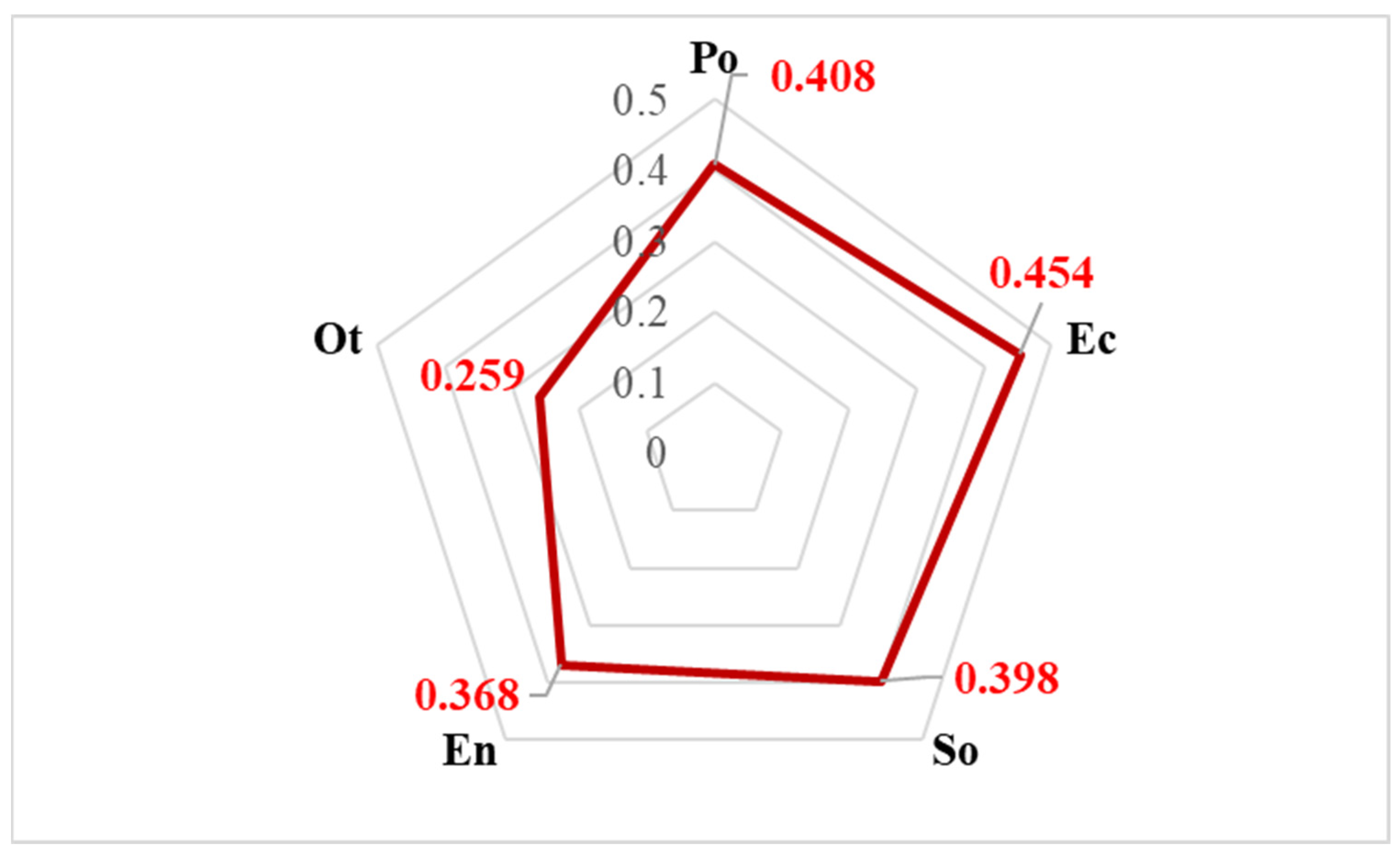
3.3. Factors Affecting Land Use Planning in Dan Phuong District
In this study, we used a multivariate regression model to determine the coefficient and influence of factors on land use planning in the Dan Phuong district. The results of the multivariate regression model analysis are described in Table 5.
Table 5.
The analysis results of Factors affecting land use planning in Dan Phuong district.
Table 5 shows that the coefficient R2 = 0.571 meant that the model could explain 57.1% of the total relationship between land use planning and the factors given from the perspective of land users. In addition, the result of the Durbin–Watson test gave a value of 2.443. This value was close to the coefficient of 2.0 and ranged from 1 to 3, proving that there was no first-order serial correlation in the analytical model [45]. On the other hand, the results of ANOVA analysis with the F-test to test the hypothesis of the suitability of the linear regression model showed that the value was Sig. = 0.000. This means that the linear regression model constructed was appropriate. The linear regression model was relatively suitable, with a statistical error level of 1.0%.
The results of Table 5 show that the influencing factors all have regression coefficients β > 0, so they have the same positive correlation as the results of land use planning in the Dan Phuong district. In addition, the variance inflation factor VIF was less than two, indicating that there was no multicollinearity phenomenon in the model. Based on the significance level (sig.) of each factor, five factors (Po, Ec, So, En, and Ot) all had an impact on the land use planning of Dan Phuong district with a statistical significance level of 99%, according to the assessment of land users with land in the planning area. The linear regression analysis equation, simulating the factors influencing land use planning in the Dan Phuong district, can be written as follows:
Land use planning = 0.408Po + 0.454Ec + 0.398So + 0.368 Eb + 0.259Ot
Figure 2 shows that the group of factors that had the strongest influence on land use planning in Dan Phuong District was the group of economic factors (coefficient β = 0.454); the second was the group of political factors (coefficient β = 0.408); the third was the group of social factors (β coefficient = 0.398); the fourth was the group of environmental factors (β coefficient = 0.368); and finally, the other group of factors came last (β coefficient = 0.259).
Figure 2.
Weight chart of factors affecting land use planning in Dan Phuong district.
By clearly pointing out five groups of factors that have a major impact on the land use planning process, it can help Dan Phuong district authorities make appropriate decisions to implement land use planning adequately in the future. In particular, it can provide guidance in allocating suitable land for the development of projects to build transport infrastructure, urban areas, industrial parks, commercial centres, etc. In addition, groups of social and environmental factors remind decision makers that the conversion of land from agricultural use to non-agricultural use has a new obligation to effectively use the remaining agricultural land fund. Due to the limited area, changing agricultural production models to ecological agriculture and circular agriculture to make the best use of land resources, adapt well to climate change and minimise emissions, protect the environment, and increase farmers’ income is a mandatory direction for this district in the coming period.
4. Discussion
4.1. Reasons for Not Completing Land Use Planning Targets for the 2011–2020 Period in the Dan Phuong District
The implementation of land use planning in Dan Phuong District for the period 2011–2020 has closely followed the objectives set out in its plan, with the perspective of exploiting and using land resources reasonably and effectively to meet the needs of socio-economic development in the process of promoting industrialisation and modernisation, creating conditions for the development of technical and social infrastructure, and accelerating the socio-economic restructuring of the district [41]. In reality, however, the district’s 10-year land use plan only reflects the land use needs of sectors, fields, and localities during the planning period without taking into account factors affecting the feasibility of planning implementation. In fact, the land use planning process in Vietnam in general, and in Dan Phuong, in particular, does not ensure innovation over time. This process often tends to determine areas that are indicators of land use criteria, while the issue of “spatial zoning in land use” is very limited by the law. In addition, the planning method still relies heavily on the subjective opinions of managers and does not ensure a full cost–benefit analysis of the three aspects of the economy–society–environment. There is also a lack of coherence and synchronisation between higher-level planning (national planning) and the specific and detailed characteristics of lower-level planning (local level). Furthermore, the process of public consultation on land use planning is still procedural, formal, and ineffective, leading to a lack of transparency in the implementation of land use planning. The lack of detailed analysis and assessment of impact factors is the main reason why the implementation of land use planning for the period 2011–2020 in Dan Phuong District is not taking place as planned. This problem has been pointed out by many scientists when studying the current status of land use planning in Vietnam [6,22,32,33] and developing countries around the world [14,23,29]. To overcome the above weaknesses in the coming period, land use planning in Vietnam needs to be approached in the direction of landscape and ecosystem services, as guided by international organisations such as the Organisation for Economic Co-operation and Development (OECD), the Food and Agriculture Organisation of the United Nations (FAO), and the International Union for Conservation of Nature (IUCN) [36]. Land use planning must be based on a system that accounts for natural capital and land resources; stakeholder interests must be comprehensively assessed and linked to a specific spatial and temporal context. At the same time, careful consideration of the factors influencing the planning process is an important determinant of the success of implementing land use planning in practice.
4.2. Factors Affecting Land Use Planning in Dan Phuong District
Five groups of factors were identified that affect the implementation of land use planning in the Dan Phuong district, including economic, policy, social, environmental, and others. Among them, the group of political factors had the highest impact coefficient with β = 0.454. This is a predicted result because Dan Phuong is a peri-urban area of Hanoi city where rapid economic development, strong urbanisation, and industrialisation created a huge demand for land use. This problem has been pointed out in studies on land use planning in urbanised and industrialised areas around the world [7,11,12,13,14]. Subsequently, the two groups of political factors and social factors have almost equal impact coefficients on the land use process with β = 0.408 and β = 0.398, respectively. These two factors are the main factors influencing most of the outcomes of land use planning implementation in Vietnam because land in Vietnam is owned by the state, and the implementation of land use and the conversion of land use purposes is highly dependent on state regulation through national and local plans [6,22]. On the other hand, Vietnamese culture attaches great importance to the value of land resources, so people’s awareness, skills, and practices often have a great impact on land use and changing land use purposes [32,33]. In addition, environmental pollution and climate change have recently become more complicated in Vietnam. Dan Phuong is a peri-urban district with a high rate of economic development and urbanisation, so the problem of environmental pollution has a greater impact on the quality of land resources. On the other hand, Dan Phuong is a sensitive area to the effects of climate change (heavy rain, storms, floods) because it belongs to the flood-discharge area of Hanoi City [41]. Thus, this group of environmental factors strongly influences the land use planning process (β = 0.368) of the district. Therefore, it is crucial to conduct a comprehensive analysis of potential disaster risks and their impacts and to integrate these considerations into all stages of land use planning and adaptation processes. In addition to the four main groups of factors mentioned above, there are some other factors (β = 0.259), such as the capacity of officials and civil servants working in land use planning, the inheritance and synchronisation of land use planning with other plans, and the orientation of economic and social development goals of Dan Phuong district in the period 2021–2030, which should also be considered and carefully considered in land use planning.
5. Conclusions
The process of implementing land use planning for the period 2011–2020 in the Dan Phuong District did not achieve the desired results as only 498.44 ha of land was converted, which was only 36.05% of the set requirement (the land to be converted according to the plan was 1382.29 ha). The reason for this result was the lack of consideration and assessment of factors affecting land use planning during the planning process. To overcome the above limitation, this study applied exploratory factor analysis (EFA) to identify the five groups of factors affecting land use planning in the Dan Phuong district, including the groups of politics (Po), economy (Ec), society (Soc), environment (En), and other (Ot). The results of running the linear regression model determined that the linear regression equation for land use planning in Dan Phuong district is land use planning = 0.408Po + 0.454Ec + 0.398So + 0.368En + 0.259Ot. Thus, the group of factors with the strongest influence was the Ec factors (β = 0.454), the second was the Po factors (β = 0.408), the third was the So factors (β = 0.398), the fourth was the En factors (β = 0.368) and the last were the Ot factors (β = 0.259). This result should be considered and applied in the preparation and implementation of this district’s land use planning for the period 2021-2030 to ensure the most effective use of land resources. In addition, the EFA method should be used in other studies to identify factors that influence land use planning, especially due to the heterogeneity of economic, social, cultural, and political factors between localities, regions, and countries.
Author Contributions
P.T.T. conceived the research idea, supervised the research, analysed the data, and drafted the manuscript. V.T.D. commented on and edited the manuscript. S.C.T. analysed the data, drafted, commented on and edited the manuscript. T.D.T. collected and analysed the data, commented and edited the manuscript. D.N.H. analysed the data, commented on and edited the manuscript. W.S. supervised the research, commented on and edited the manuscript. All authors have read and agreed to the published version of the manuscript.
Funding
This research received no external funding. We acknowledge financial support for publishing by Deutsche Forschungsgemeinschaft and Technische Universität Dortmund/TU Dortmund University within the funding programme “Open Access Publishing”.
Institutional Review Board Statement
Not applicable.
Informed Consent Statement
Not applicable.
Data Availability Statement
The data presented in this study are available on request from the corresponding author.
Conflicts of Interest
The authors declare no conflict of interest.
References
- FAO Food and Agriculture Organization of the United Nations. Guideline for Land Use Planning; FAO Development Series 1; FAO Food and Agriculture Organization: Rome, Italy, 1993; ISBN 92-5-103282-3. [Google Scholar]
- Yang, H.; Zhong, X.; Deng, S.; Xu, H. Assessment of the impact of LUCC on NPP and its influencing factors in the Yangtze River basin, China. Catena 2021, 206, 105542. [Google Scholar] [CrossRef]
- Rithmire, M.E. Land Institutions and Chinese Political Economy: Institutional Complementarities and Macroeconomic Management. Politics Soc. 2017, 45, 123–153. [Google Scholar] [CrossRef]
- Vink, A.P. A Land resources. In Land Use in Advancing Agriculture; Advanced Series in Agricultural Sciences; Springer: Berlin/Heidelberg, Germany, 1975; Volume 1. [Google Scholar] [CrossRef]
- Yi, Z.; Zhou, W.; Razzaq, A.; Yang, Y. Land resource management and sustainable development: Evidence from China’s regional data. Resour. Policy 2023, 84, 103732. [Google Scholar] [CrossRef]
- Do, V.N. The vital role of land use planning on Socio-economic development in Maichau district, Hoa Binh province. In Upland Natural Resource and Social-Ecological Systems in Northern Vietnam; Mai, V.T., Tran, D.V., Stephen, J.L., Ganesh, P.S., Eds.; Elsevier: Amsterdam, The Netherlands, 2016; Volume 2, pp. 11–87. [Google Scholar]
- Kalfas, D.; Kalogiannidis, S.; Chatzitheodoridis, F.; Toska, E. Urbanization and Land Use Planning for Achieving the Sustainable Development Goals (SDGs): A Case Study of Greece. Urban Sci. 2023, 7, 43. [Google Scholar] [CrossRef]
- Thrall, G.I. 3 Pure planning scenarios and the consumption theory of land rent. Polit. Geogr. Quart. 1983, 2, 219–231. [Google Scholar] [CrossRef]
- Mei, T.S. An Economic Turn: A Hermeneutical reinterpretation of political economy concerning the question of land. Res. Phenomenol. 2011, 41, 297–326. [Google Scholar] [CrossRef]
- Kim, J.H. Linking land use planning and regulation to economic development: A literature review. J. Plan. Lit. 2011, 26, 35–47. [Google Scholar]
- Capozza, D.R.; Helsley, R.W. The fundamentals of land prices and urban growth. J. Urban Econ. 1989, 26, 295–306. [Google Scholar] [CrossRef]
- Wu, X.X.; Huang, Y.; Gao, J. Impact of industrial agglomeration on new-type urbanization: Evidence from Pearl River Delta urban agglomeration of China. Int. Rev. Econ. Financ. 2021, 77, 312–325. [Google Scholar] [CrossRef]
- Debela, D.D.; Stellmacher, T.; Azadi, H.; Kelboro, G.; Lebailly, P.; Ghorbani, M. The Impact of Industrial Investments on Land Use and Smallholder Farmers’ Livelihoods in Ethiopia. Land Use Policy 2020, 99, 105091. [Google Scholar] [CrossRef]
- Peng, Y.; Yang, F.; Zhu, L.; Li, R.; Wu, C.; Chen, D. Comparative Analysis of the Factors Influencing Land Use Change for Emerging Industry and Traditional Industry: A Case Study of Shenzhen City, China. Land 2021, 10, 575. [Google Scholar] [CrossRef]
- Form, W.H. The place of social structure in the determination of land use. Soc. Forces. 1954, 32, 317–323. [Google Scholar] [CrossRef]
- Pacione, M. The internal structure of cities in the Third World. Geography 2001, 86, 189–209. [Google Scholar]
- Dale, V.H. The relationship between land-use change and climate change. Ecol. Appl. 1997, 7, 753–769. [Google Scholar] [CrossRef]
- Thapa, P. The Relationship between Land Use and Climate Change: A Case Study of Nepal. In The Nature, Causes, Effects and Mitigation of Climate Change on the Environment; Harris, S.A., Ed.; IntechOpen: Rijeka, Croatia, 2021. [Google Scholar]
- Barati, A.A.; Zhoolideh, M.; Azadi, H.; Lee, J.; Scheffran, J. Interactions of land-use cover and climate change at a global level: How to mitigate the environmental risks and warming effects. Ecol. Indic. 2021, 146, 109829. [Google Scholar] [CrossRef]
- Chen, D.; Stow, D. Strategies for integrating information from multiple spatial resolutions into land-use/land-cover classification routines. Photogramm. Eng. Remote Sens. 2003, 69, 1279–1287. [Google Scholar] [CrossRef]
- Mitri, G.; Nasrallah, G.; Gebrael, K.; Nassar, M.B.; Abou, M.; Dagher Nader, M.; Masri, N.; Choueiter, D. Assessing land degradation and identifying potential sustainable land management practices at the subnational level in Lebanon. Environ. Monit. Assess 2019, 191, 567. [Google Scholar] [CrossRef]
- Nam, P.P.; Yen, T.T. Determinants of the lives of households after land loss for urbanization: Experiences from Vinh city, Nghe An province. Land Use Policy 2022, 119, 106216. [Google Scholar] [CrossRef]
- Berchoux, T.; Hutton, C.W.; Hensengerth, O.; Voepel, H.E.; Tri, V.P.; Vu, P.T.; Darby, S.E. Darby Effect of planning policies on land use dynamics and livelihood opportunities under global environmental change: Evidence from the Mekong Delta. Land Use Policy 2023, 131, 106752. [Google Scholar] [CrossRef]
- Knowler, D.; Bradshaw, B. Farmers’ adoption of conservation agriculture: A review and synthesis of recent research. Food Policy 2007, 32, 25–48. [Google Scholar] [CrossRef]
- Baumgart-Getz, A.; Prokopy, L.S.; Floress, K. Why farmers adopt best management practice in the United States: A metaanalysis of the adoption literature. J. Environ. Manage 2012, 96, 17–25. [Google Scholar] [CrossRef] [PubMed]
- Van Vliet, J.; Magliocca, N.R.; Büchner, B.; Cook, E.; Rey Benayas, J.M.; Ellis, E.C.; Verburg, P.H. Meta-studies in land use science: Current coverage and prospects. Ambio 2016, 45, 15–28. [Google Scholar] [CrossRef] [PubMed]
- Giang, N.; Chinh, T.; Vien, T.; Thang, N.; An, N. Applying the Theory of Planned Behavior to Determine the Influencing Factors of Recycling Pig Wastewater for Crop Cultivation in Hanoi City. Vietnam J. Agric. Sci. 2023, 6, 1810–1820. [Google Scholar] [CrossRef]
- Zhang, Z.; Jin, G.; Hu, Y.; He, N.; Niu, J. Performance Management of Natural Resources: A Systematic Review and Conceptual Framework for China. Water 2022, 14, 3338. [Google Scholar] [CrossRef]
- Liu, M.; Jia, P.; Liu, K.; Yang, L.; Yan, H. Study on the Affecting Factors of Land Circulation in Minority Areas of Ledong County, Hainan Province, China. Sustainability 2023, 15, 5686. [Google Scholar] [CrossRef]
- Nam, P.P.; Phuong, T.T. Factors affecting commercial housing prices in Vietnam. Int. J. Hous. Mark. Anal. 2022, 15, 1019–1032. [Google Scholar] [CrossRef]
- General Statistics Office of Vietnam (GSO). Statistical Yearbook of Vietnam 2022; Statistical Publisher: Hanoi, Vietnam, 2022. [Google Scholar]
- Vu, H.T.D.; Tran, D.D.; Schenk, A.; Nguyen, C.P.; Vu, H.L.; Oberle, P.; Nestmann, F. Land use change in the Vietnamese Mekong Delta: New evidence from remote sensing. Sci. Total Environ. 2022, 813, 151918. [Google Scholar] [CrossRef]
- Bui, D.H.; Mucsi, L. Land-use change and urban expansion in Binh Duong province, Vietnam, from 1995 to 2020. Geocarto Int. 2022, 37, 17096–17118. [Google Scholar] [CrossRef]
- Vietnamese Ministry of Natural Resources and Environment (MONRE). Vietnam National Environmental Report 2012: Continental Surface Water; Vietnamese Ministry of Natural Resources and Environment (MONRE): Hanoi, Vietnam, 2012.
- Phu, N. The Impacts of Climate Change on Agricultural Production and Sustainable Agriculture of Smallholder Farmers in Vietnam. Vietnam J. Agric. Sci. 2021, 4, 1100–1107. [Google Scholar] [CrossRef]
- Tran, P.T.; Vu, B.T.; Ngo, S.T.; Tran, V.D.; Ho, T.D. Ho Climate change and livelihood vulnerability of the rice farmers in the North Central Region of Vietnam: A case study in Nghe An province, Vietnam. Environ. Chall. 2022, 7, 100460. [Google Scholar] [CrossRef]
- Bich, T.H.; Quang, L.N.; Thanh Ha, L.T.; Duc Hanh, T.T.; Guha-Sapir, D. Impacts of flood on health: Epidemiologic evidence from Hanoi, Vietnam. Glob. Health Action 2011, 4, 6356. [Google Scholar] [CrossRef] [PubMed]
- Storch, H. The Spatial Dimensions of Climate Change at the Mega-urban Scale in South East Asia: Urban Environmental Planning Strategies for Ho Chi Minh City’s Response to Climate Change. In Proceedings of the 45th ISOCARP Congress, Porto, Portugal, 20 October 2009. [Google Scholar]
- Rutten, M.; Van Dijk, M.; Van Rooij, W.; Hilderink, H. Land Use Dynamics, Climate Change, and Food Security in Vietnam: A Global-to-local Modeling Approach. World Dev. 2014, 59, 29–46. [Google Scholar] [CrossRef]
- Congress of Socialist Republic of Vietnam. Law No: 45/2013/QH13 Land Law 2013; Congress of Socialist Republic of Vietnam: Hanoi, Vietnam, 2013. [Google Scholar]
- People’s Committee of Dan Phuong District. Report: Dan Phuong District Land Use Planning for the Period 2021–2030; People’s Committee of Dan Phuong District: Hanoi, Vietnam, 2021.
- Hair, J.F.; Black, W.C.; Babin, B.J.; Anderson, R.E.; Tatham, R.L. Multivariate Data Analysis, 6th ed.; Pearson University Press: Upper Saddle River, NJ, USA, 2006. [Google Scholar]
- Likert, R.A. A technique for measurements of attitudes. Arch. Psychol. 1932, 140, 55. [Google Scholar]
- Hair, J.F., Jr.; Anderson, R.E.; Tatham, R.L.; Black, W.C. Multivariate Data Analysis, 5th ed.; Macmillan Publishing Company: New York, NY, USA, 1998. [Google Scholar]
- Hoang, T.; Chu, N.M.N. Analyze Research Data with SPSS; Hongduc Publisher: Ho Chi Minh City, Vietnam, 2008. [Google Scholar]
- Nunnally, J.C.; Bernstein, I.H. Psychometric Theory, 3rd ed.; McGraw-Hill: New York, NY, USA, 1994. [Google Scholar]
Disclaimer/Publisher’s Note: The statements, opinions and data contained in all publications are solely those of the individual author(s) and contributor(s) and not of MDPI and/or the editor(s). MDPI and/or the editor(s) disclaim responsibility for any injury to people or property resulting from any ideas, methods, instructions or products referred to in the content. |
© 2023 by the authors. Licensee MDPI, Basel, Switzerland. This article is an open access article distributed under the terms and conditions of the Creative Commons Attribution (CC BY) license (https://creativecommons.org/licenses/by/4.0/).