
Identifying Exposure of Urban Area to Certain Seismic Hazard Using Machine Learning and GIS: A Case Study of Greater Cairo


Abstract
:1. Introduction
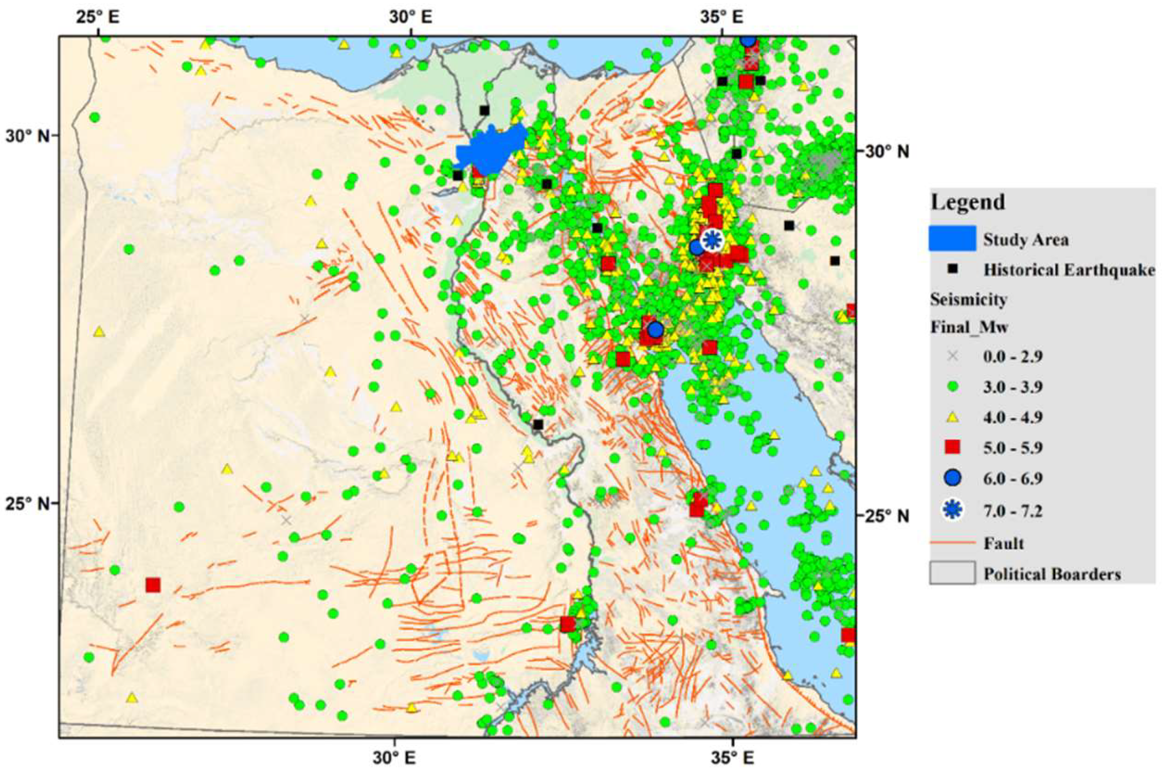
2. Case Study and Materials
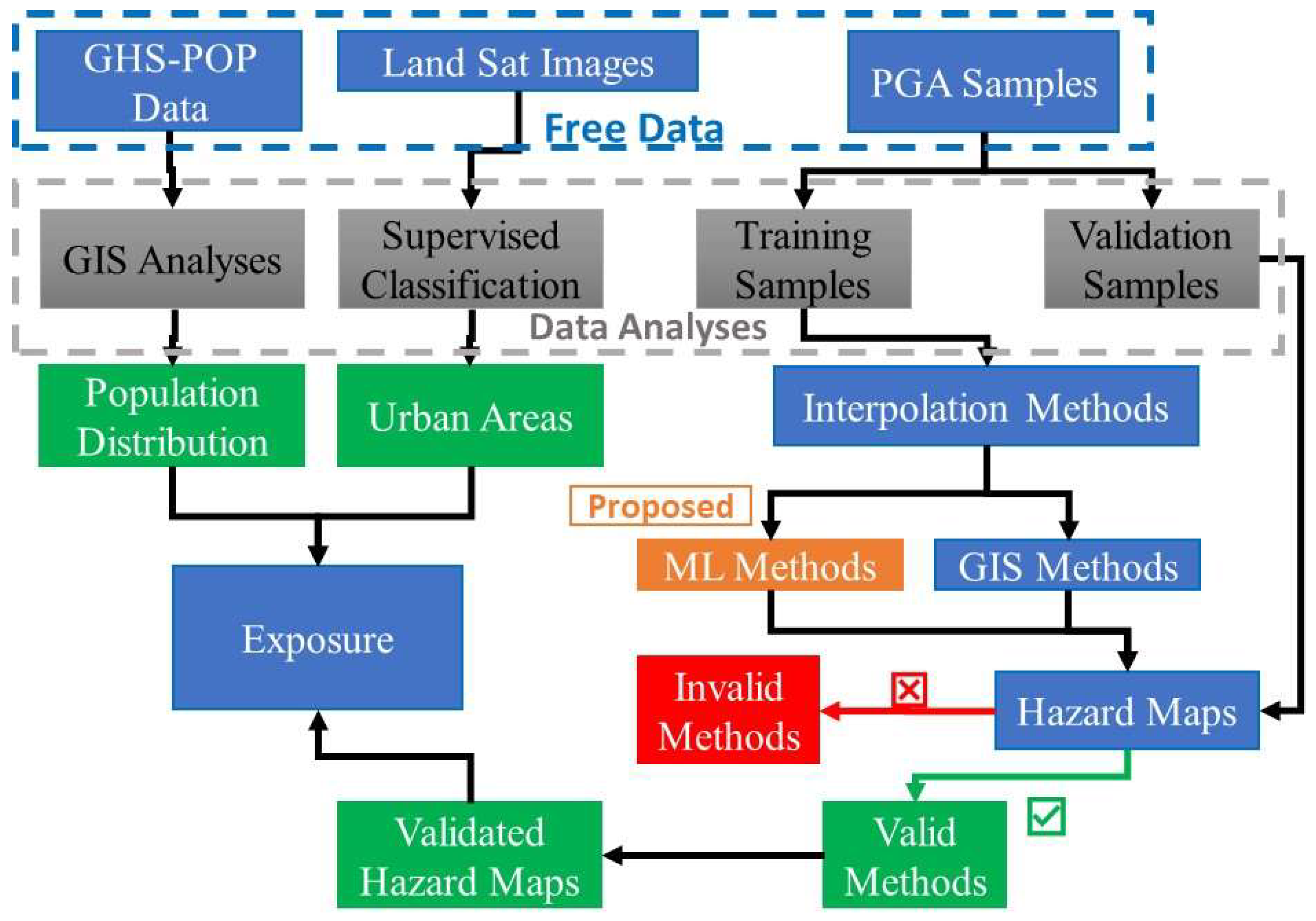
3. Methodology
3.1. Create a Seismic Hazard Map (PGA)
3.2. Landsat Classification
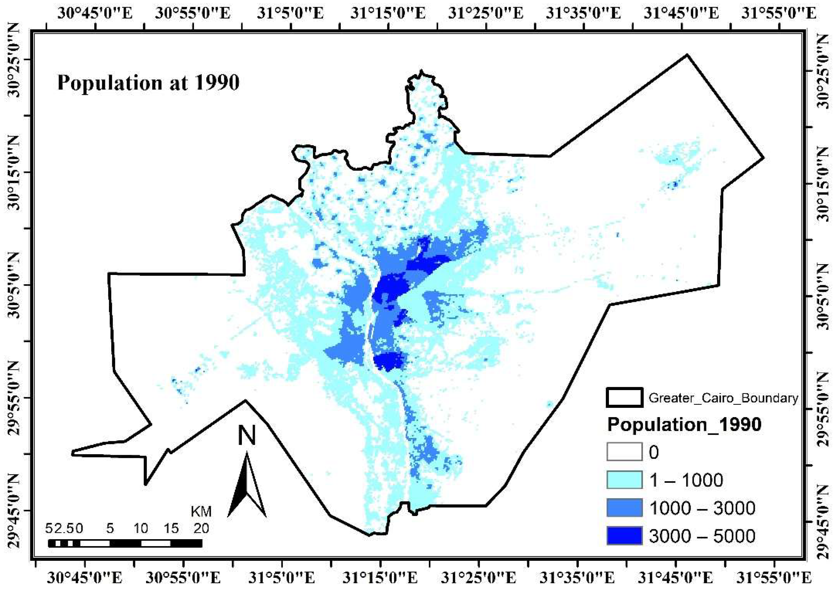
3.3. Identifying Population
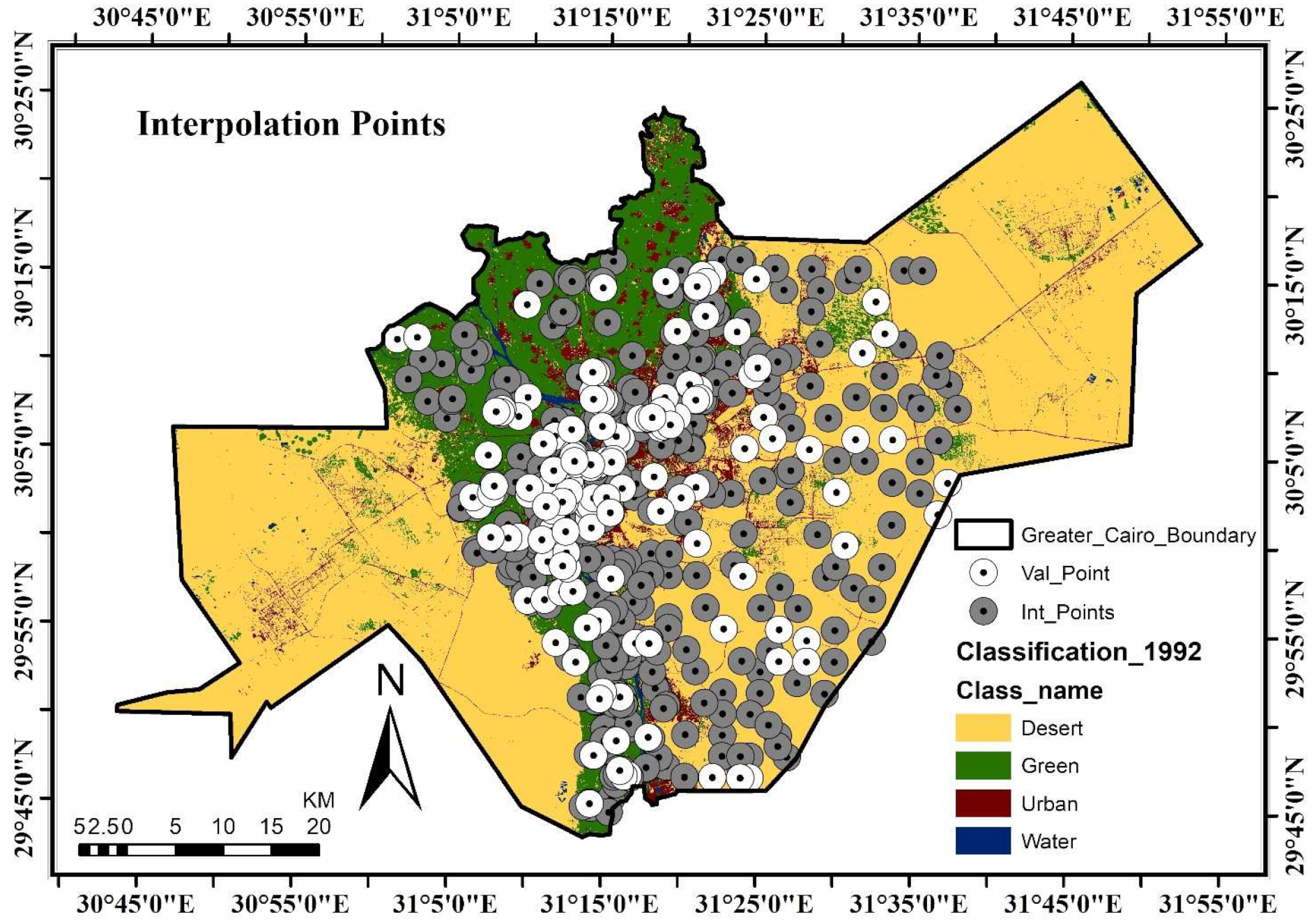
3.4. GIS Interpolation Method
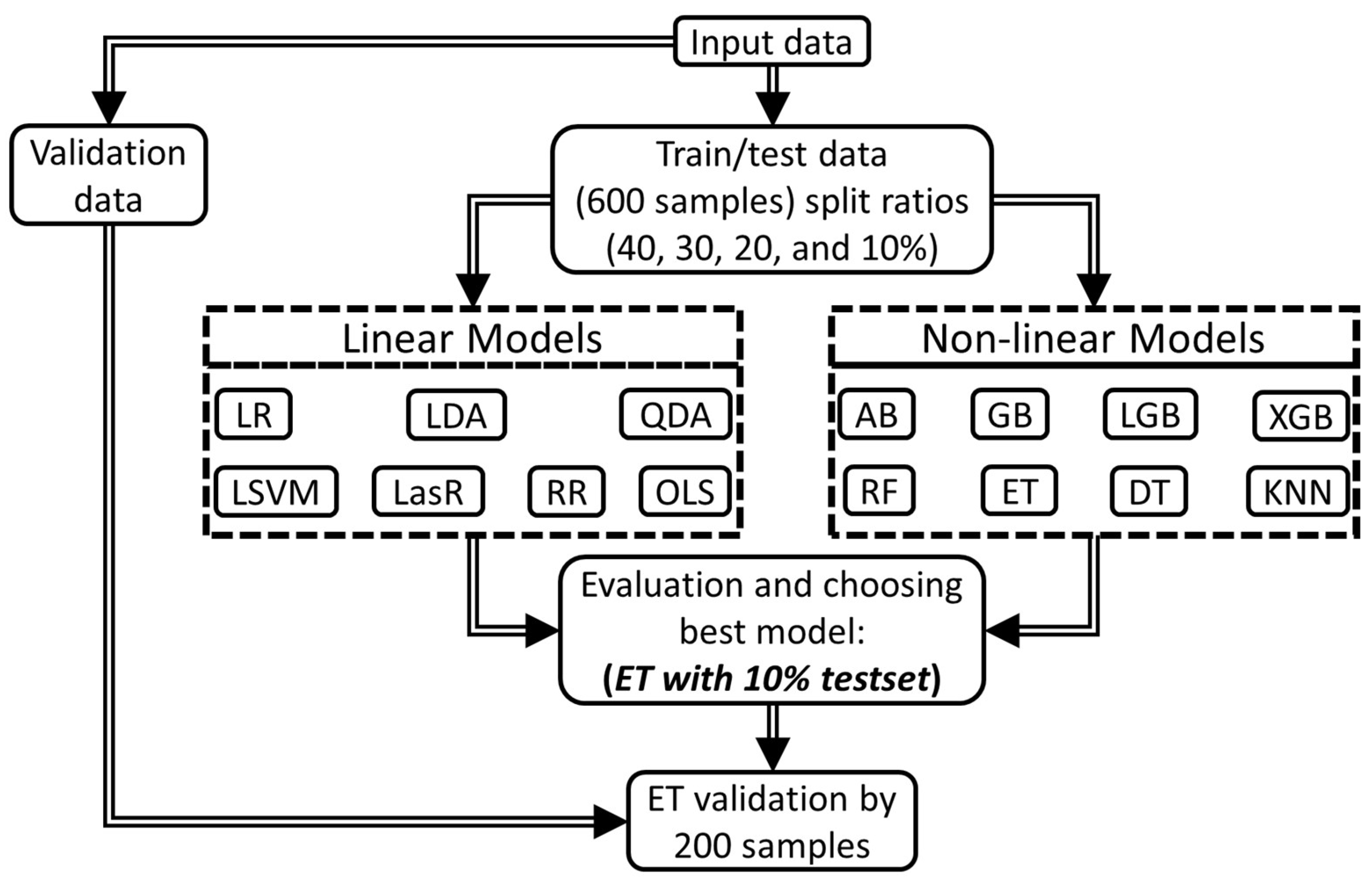
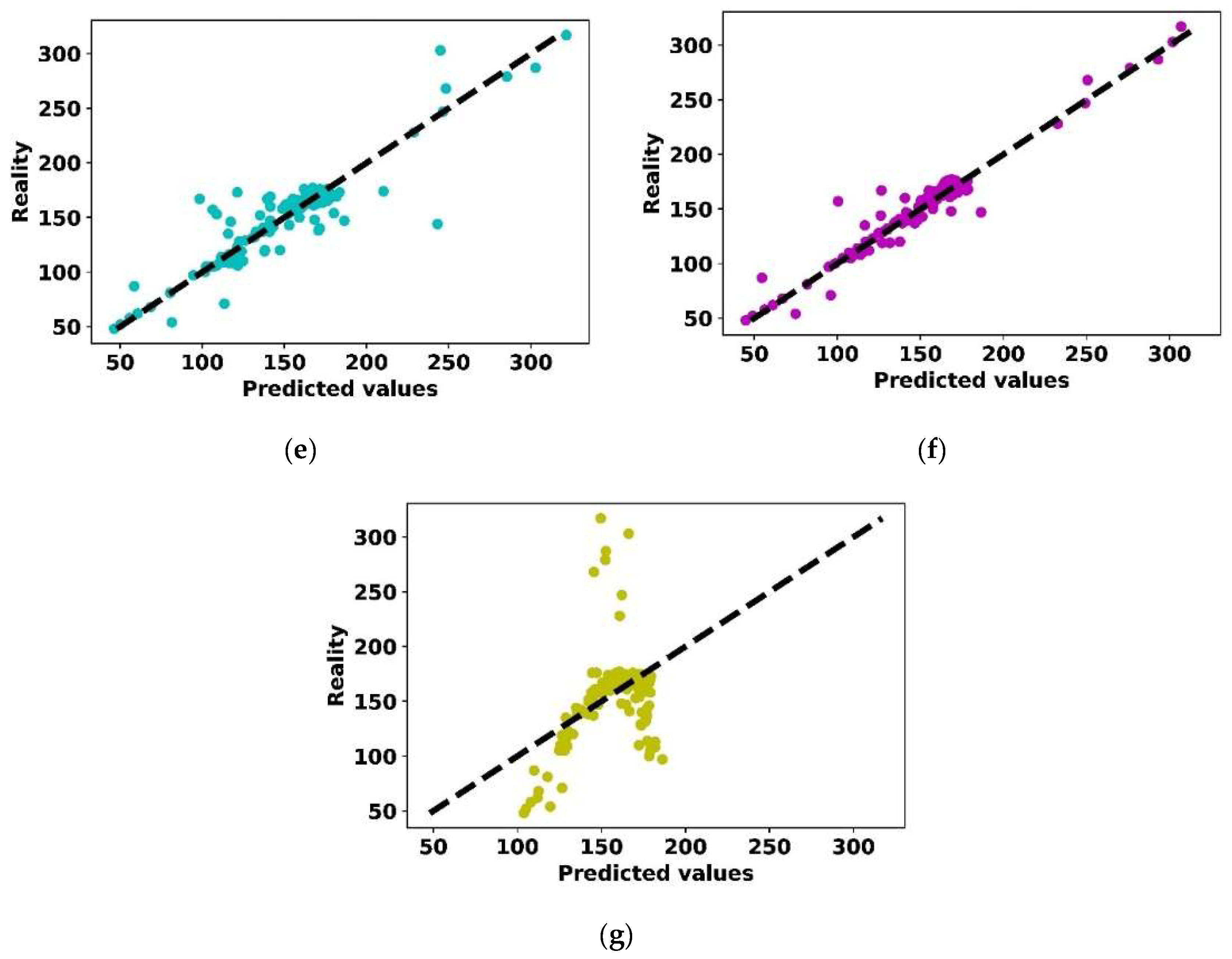
3.5. Machine Learning Methods and Evaluation Metrics
3.5.1. Employed Linear and Non-Linear Regression Models
3.5.2. Learning and Testing Process
3.5.3. Performance Evaluation and Best Model Determination
4. Results
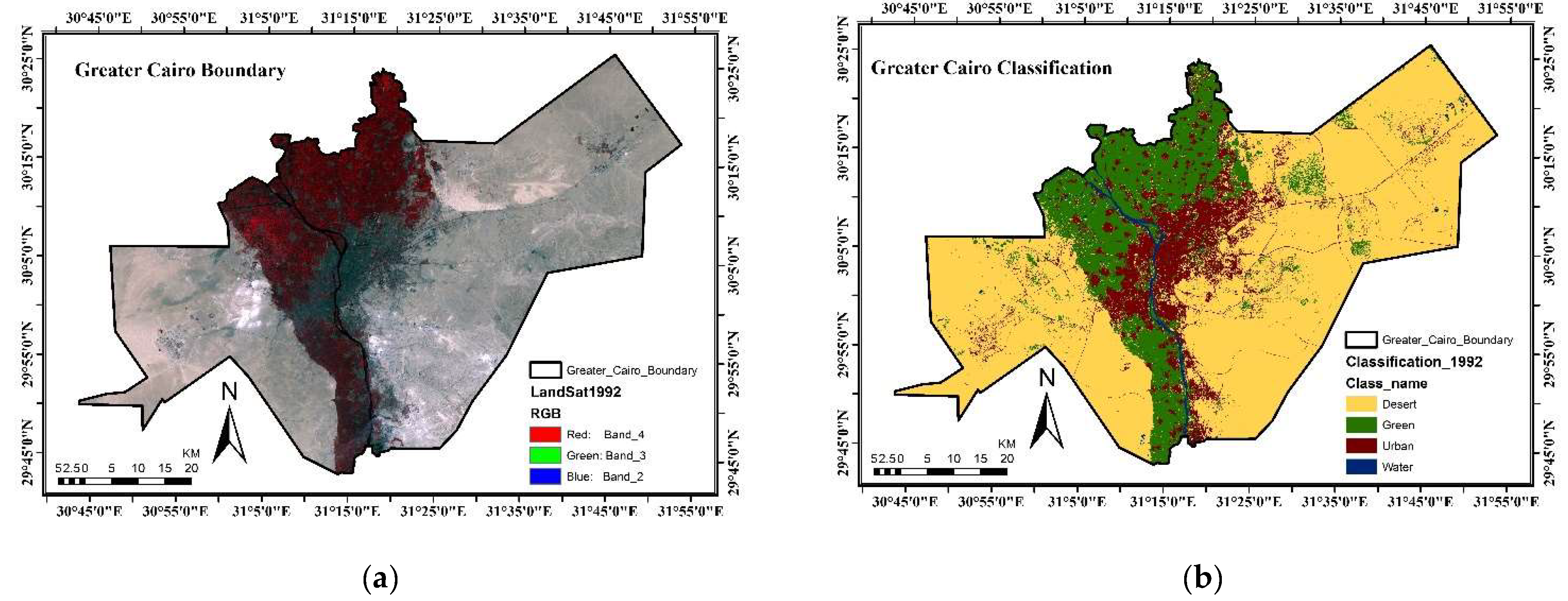
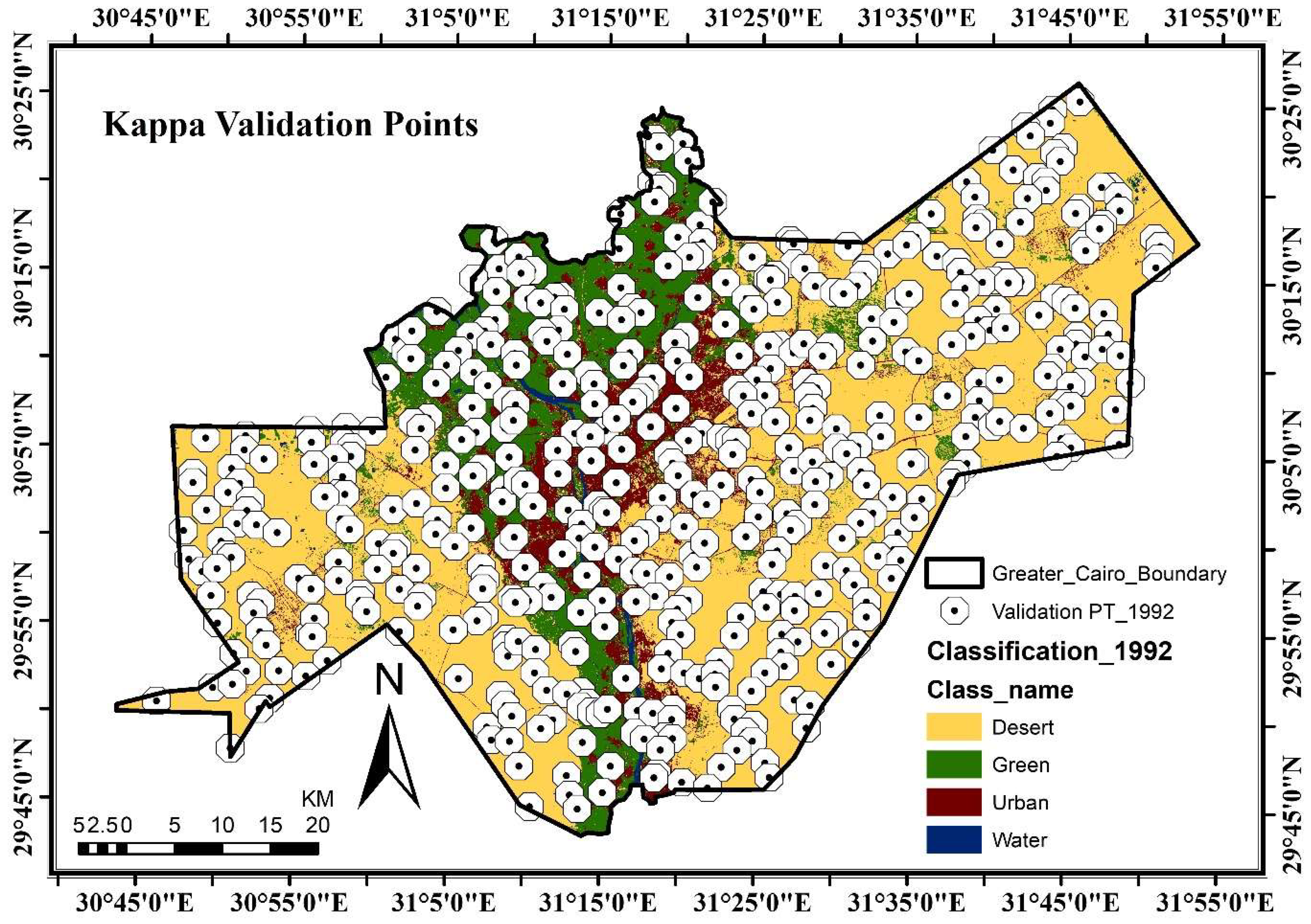
4.1. Identifying Historical Urban Area
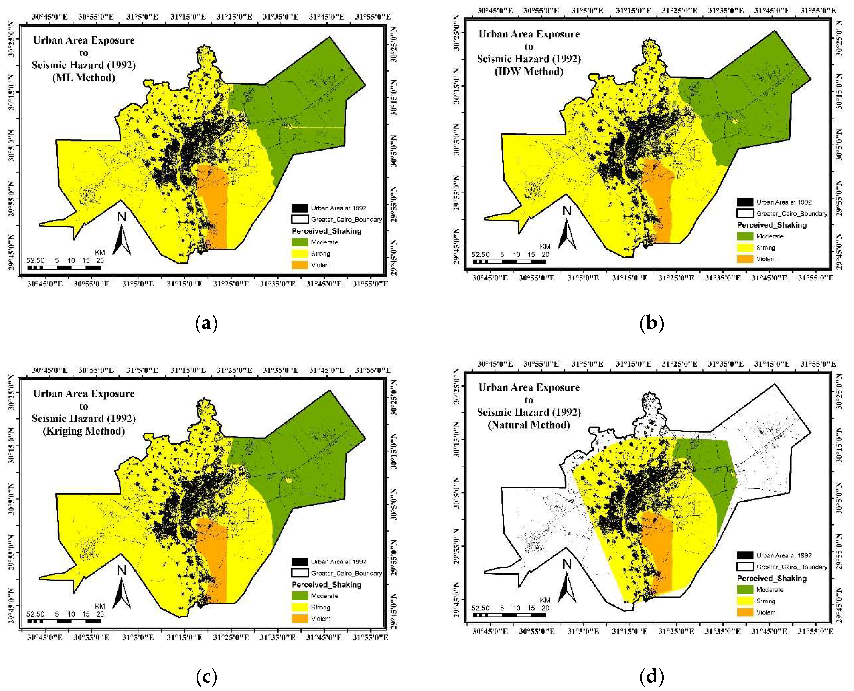
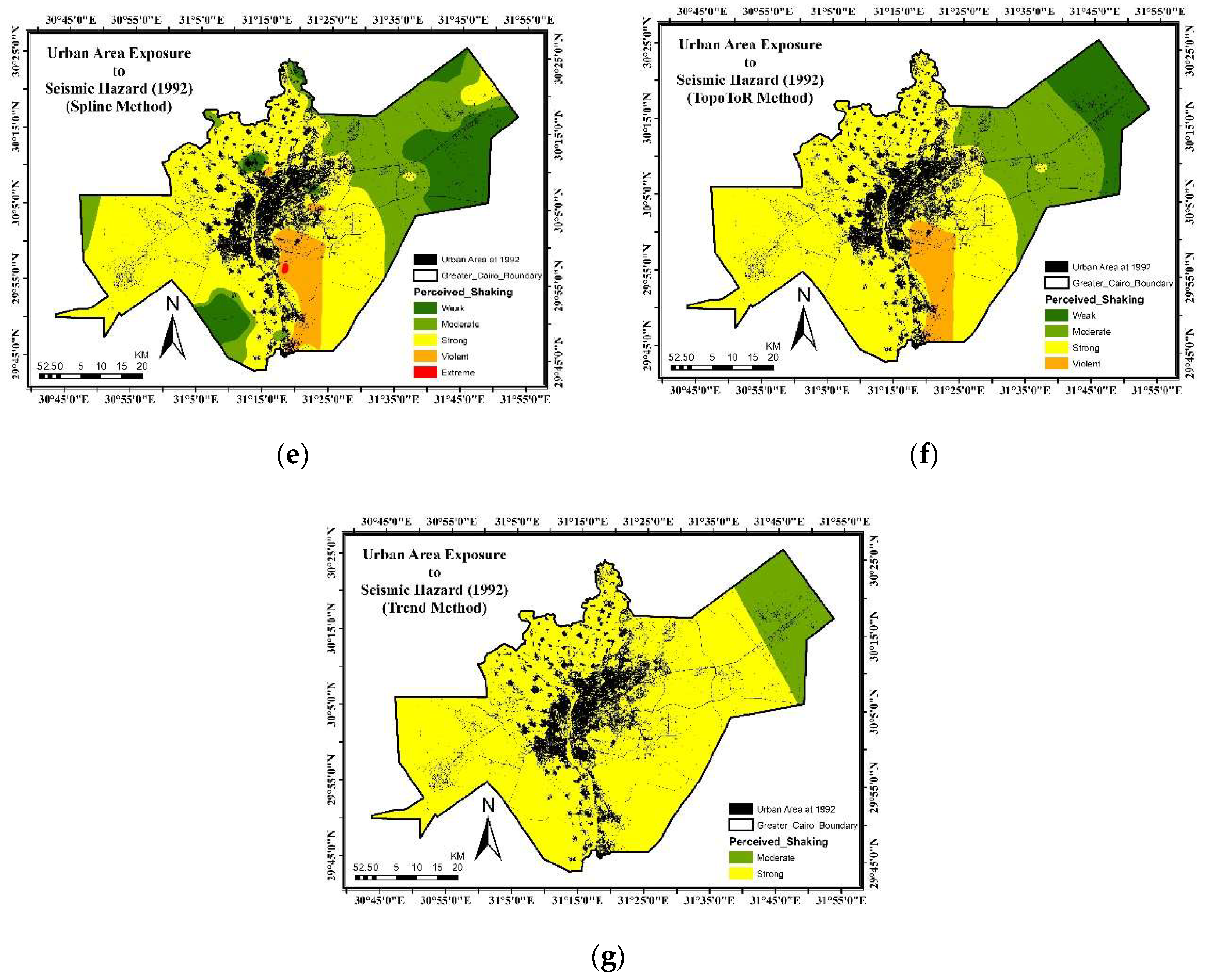
4.2. Identifying Seismic Hazard Map with Different Methods
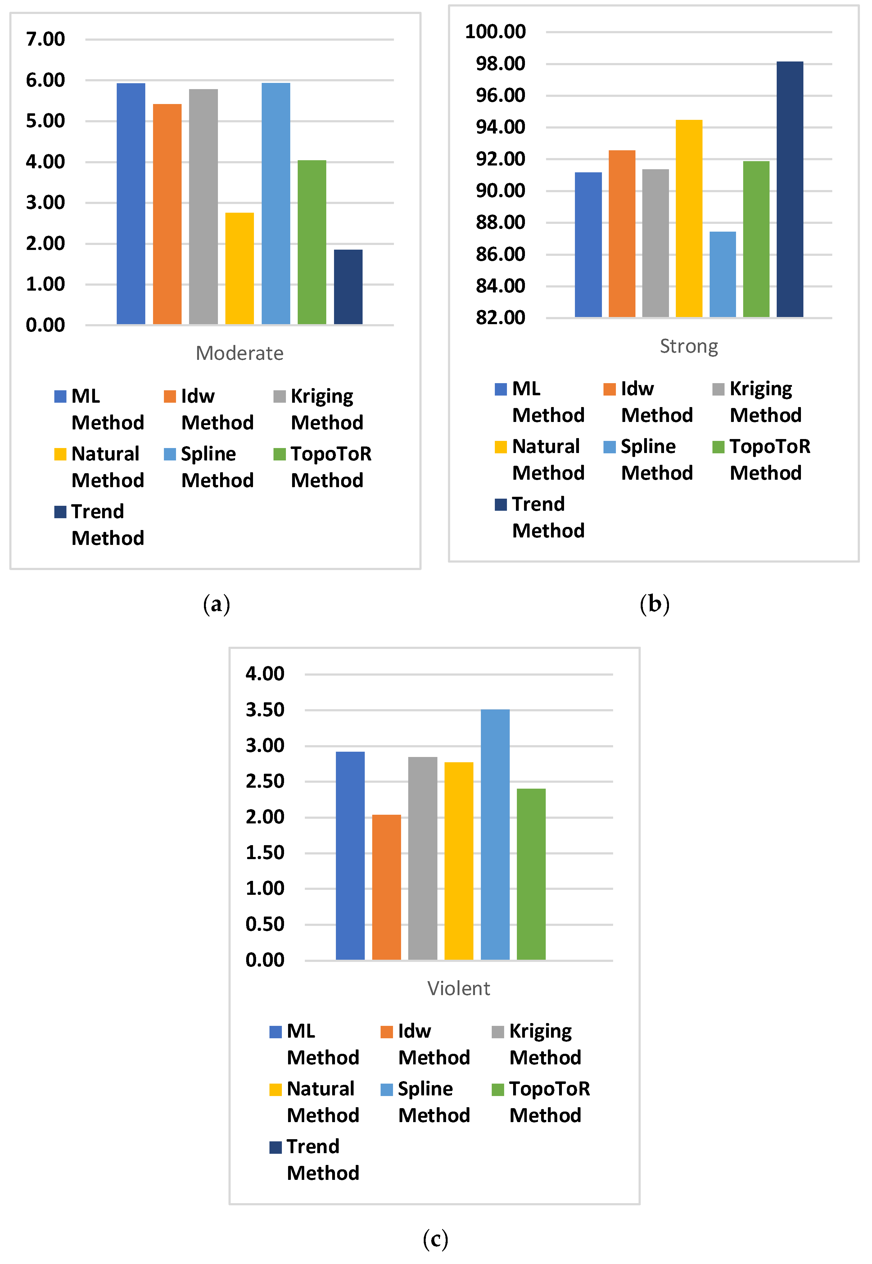
4.3. Urban Reas Exposure to Seismic Hazard
4.4. Population Exposure to Seismic Hazard
5. Discussion
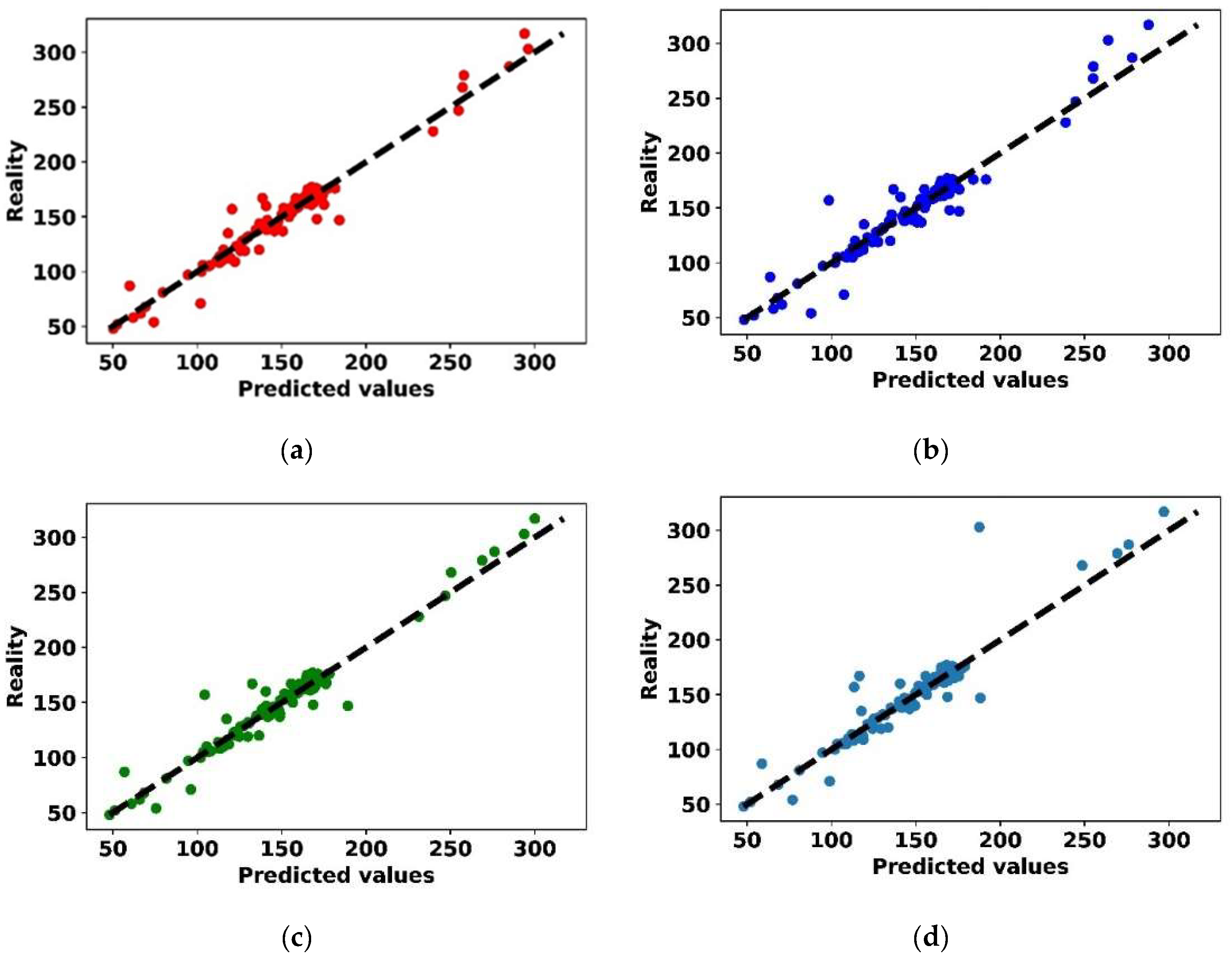
- This paper’s findings are in line with earlier research showing that the interpolation kriging method can improve spatial prediction accuracy in different data types [95,97,99], While others show that Inverse Distance Weighted and Kriging are nearly the same [95,96]. Kriging method was the best method. The Kriging method gives superior interpolation for unmeasured quantities [100,101,102].
6. Conclusions
Author Contributions
Funding
Institutional Review Board Statement
Informed Consent Statement
Data Availability Statement
Conflicts of Interest
References
- Asadi, Y.; Samany, N.N.; Ezimand, K. Seismic Vulnerability Assessment of Urban Buildings and Traffic Networks Using Fuzzy Ordered Weighted Average. J. Mt. Sci. 2019, 16, 677–688. [Google Scholar] [CrossRef]
- Gencer, E.A. Natural Disasters, Urban Vulnerability, and Risk Management: A Theoretical Overview. In The Interplay between Urban Development, Vulnerability, and Risk Management; Springer: Berlin/Heidelberg, Germany, 2013; pp. 7–43. [Google Scholar] [CrossRef]
- Words into Action Guidelines: National Disaster Risk Assessment Hazard Specific Risk Assessment. Available online: https://www.undrr.org/publication/words-action-guidelines-national-disaster-risk-assessment (accessed on 2 April 2022).
- Frankel, A. Mapping Seismic Hazard in the Central and Eastern United States. Seismol. Res. Lett. 1995, 66, 8–21. [Google Scholar] [CrossRef]
- Moustafa, S.S.R.; Abdalzaher, M.S.; Naeem, M.; Fouda, M.M. Seismic Hazard and Site Suitability Evaluation Based on Multi-Criteria Decision Analysis. IEEE Access 2022, 10, 69511–69530. [Google Scholar] [CrossRef]
- Kim, H.S.; Sun, C.G.; Kim, M.; Cho, H.I.; Lee, M.G. GIS-Based Optimum Geospatial Characterization for Seismic Site Effect Assessment in an Inland Urban Area, South Korea. Appl. Sci. 2020, 10, 7443. [Google Scholar] [CrossRef]
- Duzgun, H.S.B.; Yucemen, M.S.; Kalaycioglu, H.S.; Celik, K.; Kemec, S.; Ertugay, K.; Deniz, A. An Integrated Earthquake Vulnerability Assessment Framework for Urban Areas. Nat. Hazards 2011, 59, 917–947. [Google Scholar] [CrossRef]
- Bostenaru Dan, M.; Armas, I.; Goretti, A. Earthquake Hazard Impact and Urban Planning; Springer Science & Business Media: Berlin/Heidelberg, Germany, 2014; pp. 1–313. [Google Scholar] [CrossRef]
- Hamdy, O.; Zhao, S.; El-atty, H.A.; Ragab, A.; Salem, M. Urban Areas Management in Developing Countries: Analysis the Urban Areas Crossed with Risk of Storm Water Drains, Aswan-Egypt. Int. J. Urban Civ. Eng. 2020, 14, 96–102. [Google Scholar]
- Ghamry, E.; Mohamed, E.K.; Abdalzaher, M.S.; Elwekeil, M.; Marchetti, D.; de Santis, A.; Hegy, M.; Yoshikawa, A.; Fathy, A. Integrating Pre-Earthquake Signatures from Different Precursor Tools. IEEE Access 2021, 9, 33268–33283. [Google Scholar] [CrossRef]
- Rikimaru, A.; Roy, P.S.; Miyatake, S. Tropical Forest Cover Density Mapping. Trop. Ecol. 2002, 43, 39–47. [Google Scholar]
- Noby, M.; Michitaka, U.; Hamdy, O. Urban Risk Assessments: Framework for Identifying Land-Uses Exposure of Coastal Cities to Sea Level Rise, a Case Study of Alexandria. SVU-Int. J. Eng. Sci. Appl. 2022, 3, 78–90. [Google Scholar] [CrossRef]
- Ramadhan Kete, S.C.; Suprihatin; Tarigan, S.D.; Effendi, H. Land Use Classification Based on Object and Pixel Using Landsat 8 OLI in Kendari City, Southeast Sulawesi Province, Indonesia. IOP Conf. Ser. Earth Environ. Sci. 2019, 284, 012019. [Google Scholar] [CrossRef]
- Schneider, A. Monitoring Land Cover Change in Urban and Peri-Urban Areas Using Dense Time Stacks of Landsat Satellite Data and a Data Mining Approach. Remote Sens. Environ. 2012, 124, 689–704. [Google Scholar] [CrossRef]
- USGS GloVis-USGS. Available online: https://earthexplorer.usgs.gov/ (accessed on 20 March 2022).
- Hamdy, O.; Zhao, S.; Salheen, M.A.; Eid, Y.Y. Identifying the Risk Areas and Urban Growth by ArcGIS-Tools. Geosciences 2016, 6, 47. [Google Scholar] [CrossRef]
- Freire, S.; Macmanus, K.; Pesaresi, M.; Doxsey-Whitfield, E. Development of New Open and Free Multi-Temporal Global Population Grids at 250 m Resolution Validation of Remote Sensing Derived Emergency Mapping Maps View Project Megacities View Project. 2016. Available online: https://publications.jrc.ec.europa.eu/repository/handle/JRC100523 (accessed on 2 April 2022).
- Schiavina, M.; Freire, S.; MacManus, K. Global Human Settlement-GHS-POP-European Commission. Available online: https://ghsl.jrc.ec.europa.eu/ghs_pop2019.php (accessed on 20 March 2022).
- Florczyk, A.J.; Corbane, C.; Ehrlich, D.; Freire, S.; Kemper, T.; Maffenini, L.; Melchiorri, M.; Pesaresi, M.; Politis, P.; Schiavina, M. GHSL Data Package 2019. Luxemb. EUR 2019, 29788, 290498. [Google Scholar]
- Abdalzaher, M.S.; Elsayed, H.A. Employing Data Communication Networks for Managing Safer Evacuation during Earthquake Disaster. Simul. Model. Pract. Theory 2019, 94, 379–394. [Google Scholar] [CrossRef]
- Calka, B.; Bielecka, E. GHS-POP Accuracy Assessment: Poland and Portugal Case Study. Remote Sens. 2020, 12, 1105. [Google Scholar] [CrossRef]
- Wang, H.; Wang, Y. Analysis of Spatial Interpolation Methods. In Recent Advances in Computer Science and Information Engineering; Qian, Z., Cao, L., Su, W., Wang, T., Yang, H., Eds.; Springer: Berlin/Heidelberg, Germany, 2012; Volume 6, pp. 507–512. ISBN 978-3-642-25778-0. [Google Scholar]
- Hamdy, O.; Zhao, S.; Salheen, M.; Eid, Y. Using Arc GIS to Analyse Urban Growth towards Torrent Risk Areas (Aswan City as a Case Study). IOP Conf. Ser. Earth Environ. Sci. 2014, 20, 12009. [Google Scholar] [CrossRef]
- McCoy, J.T.; Auret, L. Machine Learning Applications in Minerals Processing: A Review. Miner. Eng. 2019, 132, 95–109. [Google Scholar] [CrossRef]
- Mohammed, M.; Khan, M.B.; Bashier, E.B.M. Machine Learning: Algorithms and Applications; CRC Press: Boca Raton, FL, USA, 2016; ISBN 1498705391. [Google Scholar]
- Abdalzaher, M.S.; Elwekeil, M.; Wang, T.; Zhang, S. A Deep Autoencoder Trust Model for Mitigating Jamming Attack in IoT Assisted by Cognitive Radio. IEEE Syst. J. 2021, 1–11. [Google Scholar] [CrossRef]
- Pradhan, B. A Comparative Study on the Predictive Ability of the Decision Tree, Support Vector Machine and Neuro-Fuzzy Models in Landslide Susceptibility Mapping Using GIS. Comput. Geosci. 2013, 51, 350–365. [Google Scholar] [CrossRef]
- Abdalzaher, M.S.; Soliman, M.S.; El-Hady, S.M.; Benslimane, A.; Elwekeil, M. A Deep Learning Model for Earthquake Parameters Observation in IoT System-Based Earthquake Early Warning. IEEE Internet Things J. 2021, 9, 8412–8424. [Google Scholar] [CrossRef]
- Moustafa, S.S.R.; Abdalzaher, M.S.; Yassien, M.H.; Wang, T.; Elwekeil, M.; Hafiez, H.E.A. Development of an Optimized Regression Model to Predict Blast-Driven Ground Vibrations. IEEE Access 2021, 9, 31826–31841. [Google Scholar] [CrossRef]
- Abdalzaher, M.S.; Moustafa, S.S.R.; Abd-Elnaby, M.; Elwekeil, M. Comparative Performance Assessments of Machine-Learning Methods for Artificial Seismic Sources Discrimination. IEEE Access 2021, 9, 65524–65535. [Google Scholar] [CrossRef]
- Moustafa, S.S.R.; Abdalzaher, M.S.; Khan, F.; Metwaly, M.; Elawadi, E.A.; Al-Arifi, N.S. A Quantitative Site-Specific Classification Approach Based on Affinity Propagation Clustering. IEEE Access 2021, 9, 155297–155313. [Google Scholar] [CrossRef]
- Maamoun, M.; Megahed, A.; Allam, A. Seismicity of Egypt. Bull. HIAG 1984, 4, 109–160. [Google Scholar]
- Ambraseys, N.N.; Melville, C.P.; Adams, R.D. The Seismicity of Egypt, Arabia and the Red Sea: A Historical Review; Cambridge University Press: Cambridge, UK, 1994. [Google Scholar]
- Sawires, R.; Peláez, J.A.; Fat-Helbary, R.E.; Ibrahim, H.A. An Earthquake Catalogue (2200 B.C. to 2013) for Seismotectonic and Seismic Hazard Assessment Studies in Egypt. In Earthquakes and Their Impact on Society; Springer: Berlin/Heidelberg, Germany, 2016; pp. 97–136. [Google Scholar] [CrossRef]
- El-Sayed, A.; Arvidsson, R.; Kulhánek, O. The 1992 Cairo Earthquake: A Case Study of a Small Destructive Event. J. Seismol. 1998, 2, 293–302. [Google Scholar] [CrossRef]
- Badawi, H.S.; Mourad, S.A. Observations from the 12 October 1992 Dahshour Earthquake in Egypt. Nat. Hazards 1994, 10, 261–274. [Google Scholar] [CrossRef]
- Badawy, A.; Korrat, I.; El-Hadidy, M.; Gaber, H. Probabilistic Earthquake Hazard Analysis for Cairo, Egypt. J. Seismol. 2016, 20, 449–461. [Google Scholar] [CrossRef]
- Mohamed, A.M.S.; Mohamed, G.E.A.; Omar, K.; Nadia, A.A. Present Stage of Recent Crustal Movements and Seismicity within Greater Cairo Area, Egypt. J. Seismol. 2014, 18, 23–35. [Google Scholar] [CrossRef]
- Abdalzaher, M.S.; El-Hadidy, M.; Gaber, H.; Badawy, A. Seismic Hazard Maps of Egypt Based on Spatially Smoothed Seismicity Model and Recent Seismotectonic Models. J. Afr. Earth Sci. 2020, 170, 103894. [Google Scholar] [CrossRef]
- Salem, M.; Tsurusaki, N.; Divigalpitiya, P.; Osman, T.; Hamdy, O.; Kenawy, E.; Barbini, A.; Malacarne, G.; Romagnoli, K.; Massari, G.A. Assessing Progress towards Sustainable Development in the Urban Periphery: A Case of Greater Cairo, Egypt. Int. J. Sustain. Dev. Plan. 2020, 15, 971–982. [Google Scholar] [CrossRef]
- Hamdy, O. Using Remote Sensing Techniques to Assess the Changes in the Rate of Urban Green Spaces in Egypt: A Case Study of Greater Cairo. Int. Des. J. 2022, 12, 53–64. [Google Scholar] [CrossRef]
- Dorra, E.M. Greater Cairo Earthquake Loss Assessment and Its Implications on the Egyptian Economy. Ph.D. Thesis, Imperial College London, London, UK, 2011. [Google Scholar]
- Dorra, E.M.; Stafford, P.J.; Elghazouli, A.Y. Seismic Vulnerability of Lifelines in Greater Cairo. In Proceedings of the 15th World Conference on Earthquake Engineering, Lisbon, Portugal, 24–28 September 2012. [Google Scholar]
- Osman, T.; Divigalpitiya, P.; Osman, M.M.; Kenawy, E.; Salem, M.; Hamdy, O. Quantifying the Relationship between the Built Environment Attributes and Urban Sustainability Potentials for Housing Areas. Buildings 2016, 6, 39. [Google Scholar] [CrossRef]
- General Organization for Physical Planning (GOPP). Greater Cairo Urban Development Strategy: Part I: Future Vision and Strategic Directions; Ministry of Housing, Utilities, and Urban Communities (MHUC): Cairo, Egypt, 2012; pp. 1–223. [Google Scholar]
- Osman, T.; Shaw, D.; Kenawy, E. An Integrated Land Use Change Model to Simulate and Predict the Future of Greater Cairo Metropolitan Region. J. Land Use Sci. 2019, 13, 565–584. [Google Scholar] [CrossRef]
- Salem, M.; Tsurusaki, N.; Divigalpitiya, P. Remote Sensing-Based Detection of Agricultural Land Losses around Greater Cairo since the Egyptian Revolution of 2011. Land Use Policy 2020, 97, 104744. [Google Scholar] [CrossRef]
- Salem, M.; Tsurusaki, N.; Divigalpitiya, P.; Osman, T. Driving Factors of Urban Expansion in Peri-Urban Areas of Greater Cairo Region. In REAL CORP 2018–EXPANDING CITIES–DIMINISHING SPACE Are “Smart Cities” the Solution or Part of the Problem of Continuous Urbanisation around the Globe? Proceedings of the 23rd International Conference on Urban Planning, Regional Development and Information Society GeoMultimedia 2018, Vienna, Austria, 4–6 April 2018; CORP—Compentence Center of Urban and Regional Planning: Vienna, Austria, 2018. [Google Scholar]
- Douglas, J. Earthquake Ground Motion Estimation Using Strong-Motion Records: A Review of Equations for the Estimation of Peak Ground Acceleration and Response Spectral Ordinates. Earth-Sci. Rev. 2003, 61, 43–104. [Google Scholar] [CrossRef]
- Deif, A. Seismic Hazard Assessment in and around Egypt in Relation to Plate Tectonics. Ph.D. Thesis, Ain Shams University, Cairo, Egypt, 1998. [Google Scholar]
- El-Hadidy, M. Seismotectonics and Seismic Hazard Studies for Sinai Peninsula, Egypt. Master’s Thesis, Ain Shams University, Cairo, Egypt, 2008. [Google Scholar]
- Mohamed, A.E.-E.A.; El-Hadidy, M.; Deif, A.; Abou Elenean, K. Seismic Hazard Studies in Egypt. NRIAG J. Astron. Geophys. 2012, 1, 119–140. [Google Scholar] [CrossRef]
- Deif, A.; Elenean, K.A.; El Hadidy, M.; Tealeb, A.; Mohamed, A. Probabilistic Seismic Hazard Maps for Sinai Peninsula, Egypt. J. Geophys. Eng. 2009, 6, 288–297. [Google Scholar] [CrossRef]
- Gaber, H.; El-Hadidy, M.; Badawy, A. Up-to-Date Probabilistic Earthquake Hazard Maps for Egypt. Pure Appl. Geophys. 2018, 175, 2693–2720. [Google Scholar] [CrossRef]
- Abrahamson, N.A.; Silva, W.J.; Kamai, R. Summary of the ASK14 Ground Motion Relation for Active Crustal Regions. Earthq. Spectra 2014, 30, 1025–1055. [Google Scholar] [CrossRef]
- Ghareeb, S. Selection and Evaluation Suitable Ground Motion Prediction Equation for Seismic Hazard Assessment in Northern Egypt. Master’s Thesis, Sohag University, Sohag, Egypt, 2018. [Google Scholar]
- Elhadidy, M.; Abdalzaher, M.S.; Gaber, H. Up-to-Date PSHA along the Gulf of Aqaba-Dead Sea Transform Fault. Soil Dyn. Earthq. Eng. 2021, 148, 106835. [Google Scholar] [CrossRef]
- Said, R. The Geology of Egypt; A.A. Balkema: Rotterdam, The Netherlands, 1990; ISBN 9061918561. [Google Scholar]
- Youssef, M.I. Structural Pattern of Egypt and Its Interpretation. AAPG Bull. 1968, 52, 601–614. [Google Scholar]
- Issawi, B. Geology of the Southwestern Desert of Egypt. Ann. Geol. Surv. Egypt 1981, 11, 57–66. [Google Scholar]
- Boore, D.M. Estimating V s (30)(or NEHRP Site Classes) from Shallow Velocity Models (Depths <30 m). Bull. Seismol. Soc. Am. 2004, 94, 591–597. [Google Scholar]
- Imai, T.; Tonouchi, K. Correlation of N Value with S-Wave Velocity and Shear Modulus. In Penetration Testing, Proceedings of the 2nd European Symposium, Amsterdam, The Netherlands, 27 May 1982; Routledge: London, UK, 1982. [Google Scholar] [CrossRef]
- Toni, M. Site Response and Seismic Hazard Assessment for the Southern Part of Cairo City, Egypt. Ph.D. Thesis, Helwan University, Helwan, Egypt, 2012. [Google Scholar]
- Classifying Landsat Image Services to Make a Land Cover Map. Available online: https://www.esri.com/arcgis-blog/products/product/imagery/classifying-landsat-image-services-to-make-a-land-cover-map/ (accessed on 27 December 2021).
- Cohen, J. A Coefficient of Agreement for Nominal Scales. Educ. Psychol. Meas. 1960, 20, 37–46. [Google Scholar] [CrossRef]
- Alsonny, Z.; Ahmed, A.M.M.A.; Hamdy, O. Studying the Effect of Urban Green Spaces Location on Urban Heat Island in Cities Using Remote Sensing Techniques, 6th October City as a Case Study. Int. Des. J. 2022, 12, 243–262. [Google Scholar] [CrossRef]
- Van Vliet, J.; Bregt, A.K.; Hagen-Zanker, A. Revisiting Kappa to Account for Change in the Accuracy Assessment of Land-Use Change Models. Ecol. Model. 2011, 222, 1367–1375. [Google Scholar] [CrossRef]
- Hamdy, O.; Zhao, S. A Study on Urban Growth in Torrent Risk Areas in Aswan, Egypt. J. Archit. Plan. (Trans. AIJ) 2016, 81, 1733–1741. [Google Scholar] [CrossRef]
- Hamdy, O.; Alsonny, Z. Assessing the Impacts of Land Use Diversity on Urban Heat Island in New Cities in Egypt, Tiba City as a Case Study. Int. Des. J. 2022, 12, 93–103. [Google Scholar] [CrossRef]
- Alsonny, Z.; Hamdy, O. Procedural Framework for Assessing the Impact of New Cities Growth on Urban Heat Island, A Case Study of 6th October City. SVU-Int. J. Eng. Sci. Appl. 2022, 3, 64–78. [Google Scholar] [CrossRef]
- Accuracy Assessment for Image Classification—ArcMap|Documentation. Available online: https://desktop.arcgis.com/en/arcmap/latest/manage-data/raster-and-images/accuracy-assessment-for-image-classification.htm (accessed on 27 December 2021).
- Compute Confusion Matrix (Spatial Analyst)—ArcMap|Documentation. Available online: https://desktop.arcgis.com/en/arcmap/latest/tools/spatial-analyst-toolbox/compute-confusion-matrix.htm (accessed on 27 December 2021).
- Types of Interpolation-Advantages and Disadvantages. Available online: https://gisresources.com/types-interpolation-methods_3/ (accessed on 24 December 2021).
- Comparing Interpolation Methods—ArcMap|Documentation. Available online: https://desktop.arcgis.com/en/arcmap/latest/tools/3d-analyst-toolbox/comparing-interpolation-methods.htm (accessed on 24 December 2021).
- James, G.; Witten, D.; Hastie, T.; Tibshirani, R. An Introduction to Statistical Learning; Springer: Berlin/Heidelberg, Germany, 2013; Volume 112. [Google Scholar]
- Abdalzaher, M.S.; Seddik, K.; Muta, O. Using Repeated Game for Maximizing High Priority Data Trustworthiness in Wireless Sensor Networks. In Proceedings of the 2017 IEEE Symposium on Computers and Communications (ISCC), Heraklion, Greece, 3–6 July 2017; pp. 552–557. [Google Scholar]
- Kleinbaum, D.G.; Dietz, K.; Gail, M.; Klein, M.; Klein, M. Logistic Regression; Springer: Berlin/Heidelberg, Germany, 2002; ISBN 0387953973. [Google Scholar]
- Ahmad, M.W.; Mourshed, M.; Rezgui, Y. Trees vs Neurons: Comparison between Random Forest and ANN for High-Resolution Prediction of Building Energy Consumption. Energy Build. 2017, 147, 77–89. [Google Scholar] [CrossRef]
- Hastie, T.; Rosset, S.; Zhu, J.; Zou, H. Multi-Class Adaboost. Stat. Its Interface 2009, 2, 349–360. [Google Scholar] [CrossRef]
- Audigé, L.; Bhandari, M.; Kellam, J. How Reliable Are Reliability Studies of Fracture Classifications? A Systematic Review of Their Methodologies. Acta Orthop. Scand. 2004, 75, 184–194. [Google Scholar] [CrossRef] [PubMed]
- Abd El-Aal, A.E.-A.K. Simulating Time-Histories and Pseudo-Spectral Accelerations from the 1992 Cairo Earthquake at the Proposed El-Fayoum New City Site, Egypt. Acta Geophys. 2008, 56, 1025–1042. [Google Scholar] [CrossRef]
- Omar, K.; Attia, M.; Fergany, E.S.; Hassoup, A.; Elkhashab, H. Modeling of Strong Ground Motion during the 1992 Cairo Earthquake in the Urban Area Northern Greater of Cairo, Egypt. NRIAG J. Astron. Geophys. 2013, 2, 166–174. [Google Scholar] [CrossRef]
- Khalil, A.E. Earthquake Ground Motion Simulation during 1992 Cairo Earthquake at Saqqara Pyramid. NRIAG J. Astron. Geophys. 2015, 6, 52–59. [Google Scholar] [CrossRef]
- Moradia, S.; Fadaeib, H.; abdolalipour Adlc, A.; Ataellahid, S. Interpolation Methods in Identification Seismic Space Risk of Earthquake Case Study: 50 Km Radius of Sarpol-e Zahab City, Kermanshah Province. In Proceedings of the 2nd International Congress on Engineering, Technology and Innovation, Darmstadt, Germany, 24–26 April 2020. [Google Scholar]
- Kim, H.-S.; Sun, C.-G.; Cho, H.-I. Geospatial Big Data-Based Geostatistical Zonation of Seismic Site Effects in Seoul Metropolitan Area. ISPRS Int. J. Geo-Inf. 2017, 6, 174. [Google Scholar] [CrossRef]
- Asadi Oskouei, E.; Delsouz Khaki, B.; Kouzegaran, S.; Navidi, M.N.; Haghighatd, M.; Davatgar, N.; Lopez-Baeza, E. Mapping Climate Zones of Iran Using Hybrid Interpolation Methods. Remote Sens. 2022, 14, 2632. [Google Scholar] [CrossRef]
- Yang, R.; Xing, B. A Comparison of the Performance of Different Interpolation Methods in Replicating Rainfall Magnitudes under Different Climatic Conditions in Chongqing Province (China). Atmosphere 2021, 12, 1318. [Google Scholar] [CrossRef]
- Lee, S.; Panahi, M.; Pourghasemi, H.R.; Shahabi, H.; Alizadeh, M.; Shirzadi, A.; Khosravi, K.; Melesse, A.M.; Yekrangnia, M.; Rezaie, F. Sevucas: A Novel Gis-Based Machine Learning Software for Seismic Vulnerability Assessment. Appl. Sci. 2019, 9, 3495. [Google Scholar] [CrossRef]
- Li, C.; Men, B.; Yin, S. Spatiotemporal Variation of Groundwater Extraction Intensity Based on Geostatistics—Set Pair Analysis in Daxing District of Beijing, China. Sustainability 2022, 14, 4341. [Google Scholar] [CrossRef]
- Ghayamghamian, M.R.; Panah, A.K.; Behroo, R.; Govahi, N. Application of Interpolation Methods for Peak Ground Acceleration Estimation in Emergency Management of Metropolises. In GeoFlorida 2010: Advances in Analysis, Modeling & Design; Geotechnical Special Publication: Orlando, FL, USA, 2010; pp. 2999–3008. [Google Scholar] [CrossRef]
- Fanos, A.M.; Pradhan, B.; Alamri, A.; Lee, C.W. Machine Learning-Based and 3d Kinematic Models for Rockfall Hazard Assessment Using LiDAR Data and GIS. Remote Sens. 2020, 12, 1755. [Google Scholar] [CrossRef]
- Li, X.; Wu, X.; Sun, M.; Yang, S.; Song, W. A Novel Intelligent Leakage Monitoring-Warning System for Sustainable Rural Drinking Water Supply. Sustainability 2022, 14, 6079. [Google Scholar] [CrossRef]
- Taromideh, F.; Fazloula, R.; Choubin, B.; Emadi, A.; Berndtsson, R. Urban Flood Risk Assessment: Integration of Decision Making and Machine Learning. Sustainability 2022, 14, 4483. [Google Scholar] [CrossRef]
- AlHamaydeh, M.; Al-Shamsi, G.; Aly, N.; Ali, T. Seismic Risk Quantification and GIS-Based Seismic Risk Maps for Dubai-UAE_Dataset. Data Brief 2021, 39, 107566. [Google Scholar] [CrossRef]
- Cao, W.; Hu, J.; Yu, X. A Study on Temperature Interpolation Methods Based on GIS. In Proceedings of the 2009 17th International Conference on Geoinformatics, Fairfax, VA, USA, 12–14 August 2009; IEEE: New York, NY, USA, 2009; pp. 1–5. [Google Scholar]
- Setianto, A.; Triandini, T. Comparison of Kriging and Inverse Distance Weighted (IDW) Interpolation Methods in Lineament Extraction and Analysis. J. Appl. Geol. 2013, 5, 21–29. [Google Scholar] [CrossRef]
- Ding, Y.; Wang, Y.; Miao, Q. Research on the Spatial Interpolation Methods of Soil Moisture Based on GIS. In Proceedings of the International Conference on Information Science and Technology, Nanjing, China, 26–28 March 2011; IEEE: New York, NY, USA, 2011; pp. 709–711. [Google Scholar]
- Bhunia, G.S.; Shit, P.K.; Maiti, R. Comparison of GIS-Based Interpolation Methods for Spatial Distribution of Soil Organic Carbon (SOC). J. Saudi Soc. Agric. Sci. 2018, 17, 114–126. [Google Scholar] [CrossRef]
- Meng, Q.; Liu, Z.; Borders, B.E. Assessment of Regression Kriging for Spatial Interpolation-Comparisons of Seven GIS Interpolation Methods. Cartogr. Geogr. Inf. Sci. 2013, 40, 28–39. [Google Scholar] [CrossRef]
- Tripathi, R.; Nayak, A.K.; Shahid, M.; Raja, R.; Panda, B.B.; Mohanty, S.; Kumar, A.; Lal, B.; Gautam, P.; Sahoo, R.N. Characterizing Spatial Variability of Soil Properties in Salt Affected Coastal India Using Geostatistics and Kriging. Arab. J. Geosci. 2015, 8, 10693–10703. [Google Scholar] [CrossRef]
- Venteris, E.R.; May, C.J. Cost-Effective Mapping of Benthic Habitats in Inland Reservoirs through Split-Beam Sonar, Indicator Kriging, and Historical Geologic Data. PLoS ONE 2014, 9, e95940. [Google Scholar] [CrossRef]
- Varouchakis, E.A.; Hristopulos, D.T. Comparison of Stochastic and Deterministic Methods for Mapping Groundwater Level Spatial Variability in Sparsely Monitored Basins. Environ. Monit. Assess. 2013, 185, 1–19. [Google Scholar] [CrossRef]


| Category | Details | Source | |
|---|---|---|---|
| Landsat | year 1992 | Landsat 4–5 TM, Date Acquired: 3 October | United States Geological Survey, Downloaded from earth explorer tool at https://earthexplorer.usgs.gov/ (accessed on 1 March 2022). Geotechnical data is provided by the General Authority of Educational Buildings, Egypt and Sarhan (2012) |
| PGA | year 2005 | Geotechnical boreholes | |
| Population | year 1990 | GHS population grid, derived from GPW4, (1990) | European Commission Downloaded from https://ghsl.jrc.ec.europa.eu/ghs_pop.php (accessed on 1 March 2022). [19] |
| Class Name | Area (Ha) | Area (%) |
|---|---|---|
| Desert | 290,843 | 66.63% |
| Green | 85,279 | 19.54% |
| Urban | 55,085 | 12.62% |
| Water | 5287 | 1.21% |
| Total | 436,494 | 100% |
| Class Value | Desert | Green | Urban | Water | Total | U_Accuracy | Kappa |
|---|---|---|---|---|---|---|---|
| Desert | 320.00 | 3.00 | 10.00 | 0.00 | 333.00 | 0.96 | 0.00 |
| Green | 9.00 | 85.00 | 4.00 | 0.00 | 98.00 | 0.87 | 0.00 |
| Urban | 6.00 | 0.00 | 57.00 | 0.00 | 63.00 | 0.90 | 0.00 |
| Water | 1.00 | 0.00 | 1.00 | 8.00 | 10.00 | 0.80 | 0.00 |
| Total | 336.00 | 88.00 | 72.00 | 8.00 | 504.00 | 0.00 | 0.00 |
| P_Accuracy | 0.95 | 0.97 | 0.79 | 1.00 | 0.00 | 0.93 | 0.00 |
| Kappa | 0.00 | 0.00 | 0.00 | 0.00 | 0.00 | 0.00 | 0.87 |
| Accuracy | ML Method | IDW Method | Kriging Method | Natural Method | Spline Method | TopoToR Method | Trend Method |
|---|---|---|---|---|---|---|---|
| R2 value | 0.96 | 0.93 | 0.95 | 0.88 | 0.82 | 0.95 | 0.19 |
| MSE | 72.91 | 106.45 | 82.11 | 179.73 | 288.81 | 89.29 | 1329.97 |
| RMSE | 8.54 | 10.32 | 9.06 | 13.41 | 16.99 | 9.45 | 36.47 |
| Intensity | PGA (Gal) | Perceived Shaking | Potential Damage |
|---|---|---|---|
| 0 | <0.8 | Not felt | None |
| 1 | 0.8–2.5 | Very light | None |
| 2 | 2.5–8 | Light | None |
| 3 | 8–25 | Weak | None |
| 4 | 25–80 | Moderate | Very light |
| 5 | 80–250 | Strong | Light |
| 6 | 250–400 | Violent | Moderate |
| 7 | >400 | Extreme | Heavy |
| Perceived Shaking | ML Method | GIS Interpolation Methods | Potential Damage | ||||||||||||
|---|---|---|---|---|---|---|---|---|---|---|---|---|---|---|---|
| IDW | Kriging | Natural | Spline | TopoToR | Trend | ||||||||||
| Ha | % | Ha | % | Ha | % | Ha | % | Ha | % | Ha | % | Ha | % | ||
| Weak | 0 | 0.00 | 0 | 0.00 | 0 | 0.00 | 0 | 0.00 | 1714 | 3.12 | 927 | 1.69 | 0 | 0.00 | None |
| Moderate | 3259 | 5.93 | 2975 | 5.41 | 3180 | 5.78 | 1316 | 2.76 | 3264 | 5.94 | 2221 | 4.04 | 1019 | 1.85 | Very Light |
| Strong | 50,114 | 91.15 | 50,884 | 92.55 | 50,233 | 91.37 | 45,136 | 94.47 | 48,070 | 87.43 | 50510 | 91.87 | 53,960 | 98.15 | Light |
| Violent | 1606 | 2.92 | 1120 | 2.04 | 1567 | 2.85 | 1323 | 2.77 | 1930 | 3.51 | 1321 | 2.40 | 0 | 0.00 | Moderate |
| Extreme | 0 | 0.00 | 0 | 0.00 | 0 | 0.00 | 0 | 0.00 | 1 | 0.002 | 0 | 0.00 | 0 | 0.00 | Heavy |
| Urban Area | 54,979 | 100 | 54,979 | 100 | 54,979 | 100 | 47,776 | 100 | 54,979 | 100 | 54,979 | 100 | 54,979 | 100 | Urban Area |
| Perceived Shaking | ML Method | GIS Interpolation Methods | Potential Damage | ||||||||||||
|---|---|---|---|---|---|---|---|---|---|---|---|---|---|---|---|
| IDW | Kriging | Natural | Spline | TopoToR | Trend | ||||||||||
| 1000 Capita | % | 1000 Capita | % | 1000 Capita | % | 1000 Capita | % | 1000 Capita | % | 1000 Capita | % | 1000 Capita | % | ||
| Weak | 0 | 0 | 0 | 0 | 0 | 0 | 0 | 0 | 150 | 1 | 76 | 1 | 0 | 0 | None |
| Moderate | 179 | 1 | 164 | 1 | 179 | 1 | 57 | 0 | 323 | 3 | 104 | 1 | 95 | 1 | Very Light |
| Strong | 12,380 | 96 | 12,513 | 97 | 12,412 | 96 | 11,804 | 97 | 12,055 | 93 | 12,438 | 96 | 12,810 | 99 | Light |
| Violent | 345 | 3 | 228 | 2 | 313 | 2 | 300 | 2 | 377 | 3 | 287 | 2 | 0 | 0 | Moderate |
| Extreme | 0 | 0 | 0 | 0 | 0 | 0 | 0 | 0 | 0 | 0 | 0 | 0 | 0 | 0 | Heavy |
| Population (1000) | 12,904 | 100 | 12,904 | 100 | 12,904 | 100 | 12160 | 100 | 12,904 | 100 | 12,904 | 100 | 12,904 | 100 | Population (1000) |
Publisher’s Note: MDPI stays neutral with regard to jurisdictional claims in published maps and institutional affiliations. |
© 2022 by the authors. Licensee MDPI, Basel, Switzerland. This article is an open access article distributed under the terms and conditions of the Creative Commons Attribution (CC BY) license (https://creativecommons.org/licenses/by/4.0/).
Share and Cite
Hamdy, O.; Gaber, H.; Abdalzaher, M.S.; Elhadidy, M. Identifying Exposure of Urban Area to Certain Seismic Hazard Using Machine Learning and GIS: A Case Study of Greater Cairo. Sustainability 2022, 14, 10722. https://doi.org/10.3390/su141710722
Hamdy O, Gaber H, Abdalzaher MS, Elhadidy M. Identifying Exposure of Urban Area to Certain Seismic Hazard Using Machine Learning and GIS: A Case Study of Greater Cairo. Sustainability. 2022; 14(17):10722. https://doi.org/10.3390/su141710722
Chicago/Turabian StyleHamdy, Omar, Hanan Gaber, Mohamed S. Abdalzaher, and Mahmoud Elhadidy. 2022. "Identifying Exposure of Urban Area to Certain Seismic Hazard Using Machine Learning and GIS: A Case Study of Greater Cairo" Sustainability 14, no. 17: 10722. https://doi.org/10.3390/su141710722
APA StyleHamdy, O., Gaber, H., Abdalzaher, M. S., & Elhadidy, M. (2022). Identifying Exposure of Urban Area to Certain Seismic Hazard Using Machine Learning and GIS: A Case Study of Greater Cairo. Sustainability, 14(17), 10722. https://doi.org/10.3390/su141710722