Article

Permeability of Waterfronts—Contemporary Approach in Designing Urban Blue Spaces

by
Anastasiia Dubinina
1,
Aleksandra Wawrzyńska
2 and
Karolina A. Krośnicka
1,*
1
Department of Urban Design and Regional Planning, Faculty of Architecture, Gdańsk University of Technology, 80-233 Gdańsk, Poland
2
Department of Transport and Logistic, Gdynia Maritime University, 81-225 Gdynia, Poland
*
Author to whom correspondence should be addressed.
Sustainability 2022, 14(15), 9357; https://doi.org/10.3390/su14159357
Submission received: 29 May 2022 / Revised: 16 July 2022 / Accepted: 27 July 2022 / Published: 30 July 2022
(This article belongs to the Special Issue City and Port: Waterfront Integration for Sustainability)

Abstract

:
The constant struggle with rising sea levels and flood hazards has resulted in the change of the paradigm in shaping urban waterfronts towards increasing their permeability and creation of urban blue spaces. The aim of the paper was to indicate a new approach in designing public spaces at the sea–land interface by presenting a comparative study of the design solutions used in case of the four selected case studies: the Sea Organs in Zadar (Croatia), Norwegian National Opera and Ballet in Oslo (Norway), the Coastal Public Sauna in Helsinki (Finland) and Tel Aviv’s Central Promenade (Israel). The studied examples take into account the permeability of waterfronts (understood as a feature of the edge between water–land consisting of being soft and permeable). The authors decided to use the case study method as the main approach, analyzing such elements as: the site’s location and urban context, features of urban and architectural design (with usage of graphic methods and a qualitative description), and the land–water edge type (defined according the existing typologies). The study proved, that in recent years the designers have started to replace the vertical quay walls, which create a “rigid” water–land border, with multi-level solutions having a high degree of permeability for water.

1. Introduction

Waterfronts have always been the catchment area of human socio-cultural life in port cities and they were evolving towards increasing porosity of their edges [1,2]. Due to the constant urbanization pressure on the one hand and the process of port functions’ of migration towards the sea on the other [3,4,5,6,7], waterfronts constantly evolve, being usually transformed into new, active centers of port cities [8,9,10,11,12,13,14,15,16]. In the literature [17] the strong social impacts of the process of urban waterfront regeneration were identified. Waterfronts regeneration creates new economic development opportunities and it gives a chance for linking the water to a city [18]. Therefore, waterfronts have become not only attractive in terms of real estate, but also as extremely important urban structures, setting new standards for city design and being a powerful tool for the spatial transformations of port cities (just to mention such waterfront revitalization projects as in Boston, Hamburg, Goteborg, Shanghai, Toronto). According to some authors [19] waterfront regeneration might be also used as tool supporting local decision making processes in the context of integrated coastal zone management (ICZM).
However, the functional transformation of the waterfront zone often requires its adaptation to changes in water levels. This seems extremely important at the present time, especially considering that 2020 global mean sea level (GMSL) was the highest ever measured. Global mean sea level reconstructions based on observations show an increase of 21 cm from 1900 to 2020 at an average rate of 1.7 mm/year [20,21]. The growth rate of GMSL increased significantly to 3.3 mm/year in 1993–2018 and 3.7 mm/year in 2006–2018, i.e., more than twice as fast as in the 20th century [21,22]. Global climate models predict that the average global sea level rise in the 21st century (i.e., in 2100 compared to the 1995–2014 period) will be from 0.28–0.55 m to as much as 0.63–1.02 m for very unfavorable climatic conditions. [23]. With regard to the Baltic Sea, satellite measurements show that the absolute sea level in the Baltic Sea rises by an average of 3 to 5 mm per year, while in other parts of European seas and oceans, water levels rise by an average of 1 to 4 mm per year. However, in the case of the Mediterranean Sea, based on the minimum and maximum scenarios until 2040–2050, it was found that the total average sea level rise in the basin will be 9.8 and 25.6 cm.
The constant struggle with flood hazards has resulted in the need to create appropriate infrastructure protection at the land–water interface. A large proportion of coastal cities and regions is currently introducing plans and strategies for reshaping waterfronts in order to make them adapt to rising sea levels, sometimes as documents devoted solely to the issue of flooding protection (e.g., Boston [24]), and sometimes as a part of a wider climate change adaptation strategy of a city (e.g., Oslo [25], Helsinki [26], Tel Aviv [27]).
In the case of operating port quays, where it is necessary to maintain the cargo handling function, the ordinate of the quay walls is usually raised to a safe height that is not any longer a subject to flooding. In case of public spaces on waterfronts however, it is possible to change the paradigm of shaping waterfronts towards increasing their permeability, and using water as an active part of the urban blue public spaces [1,2,28,29,30,31,32,33,34,35,36,37]. Even the flood protection infrastructure might be planned as being multifunctional and integrated with the design of public space [33,34]. A reflection of these changes is even seen in semantics and the vocabulary of city strategies—the phrase “fight with water” is increasingly being replaced by the such phrases as: “working with water”, “living with water”, “place for the river” [35]. The wharfs, being so far a rigid border between water and the land area of public spaces, are therefore gradually transforming from simple vertical quay–wall structures into a complex, multi-level set of urban landscape elements. The transformed, interactive waterfronts usually create public spaces of a special importance for the mental map of the city [38,39] and they contribute to a gradual change in the man-made landscape we encounter in coastal cities [4,40,41,42,43,44]. An extended study of waterfronts’ regeneration examples with their typologies were provided recently by Sanches [44], Dal Cin et al. [35].
The aim of the paper was to indicate a new approach in redesigning waterfronts into public spaces at the sea–land interface by presenting a comparative study of the representative solutions used in the case of the four selected study cases: the Sea Organs in Zadar (Croatia), Norwegian National Opera and Ballet in Oslo (Norway), Coastal public sauna Löyly in Helsinki (Finland) and Tel Aviv’s Central Promenade Renewal (Israel). The studied examples originating from recent years (from 2005 to 2018) take into account the permeability of the waterfronts and the flow of people. The work examines the spatial features of the urban blue public spaces located on these redesigned waterfronts. The concept of urban blue public space is understood here as a commonly accessible area consisting of both water and land and including therefore at least one land–water edge [2].

2. Materials and Methods

The paper aimed to study the chosen study cases and to answer the following research questions: what architectural and urban solutions are used when redesigning already existing quay structures of public spaces in order to deal with the high flood risk? What are the methods of incorporating water into public spaces by reshaping their edges? By what architectural tools is the users’ access to water ensured and how is the movement of people led?
Various research methods were used in the article, including data and report analysis as well as a comparative analysis of architectural and urban projects, their synthesis and description. The article is based primarily on secondary research of scientific and professional literature, which allowed for a comparative analysis of the spaces located on the waterfronts of European cities. The authors decided to use the case study method as the main approach to presenting the paradigm shift in shaping coastal public spaces.
The study case selection process consisted of the following stages:
-
extensive analysis of studies of blue urban spaces transformations, realized on an architectural and urban scale in 2005–2021, in the context of their water–land relationships, on the basis of professional literature [44,45,46,47,48,49], scientific literature [1,15,35,50,51,52,53,54] and our own field research;
-
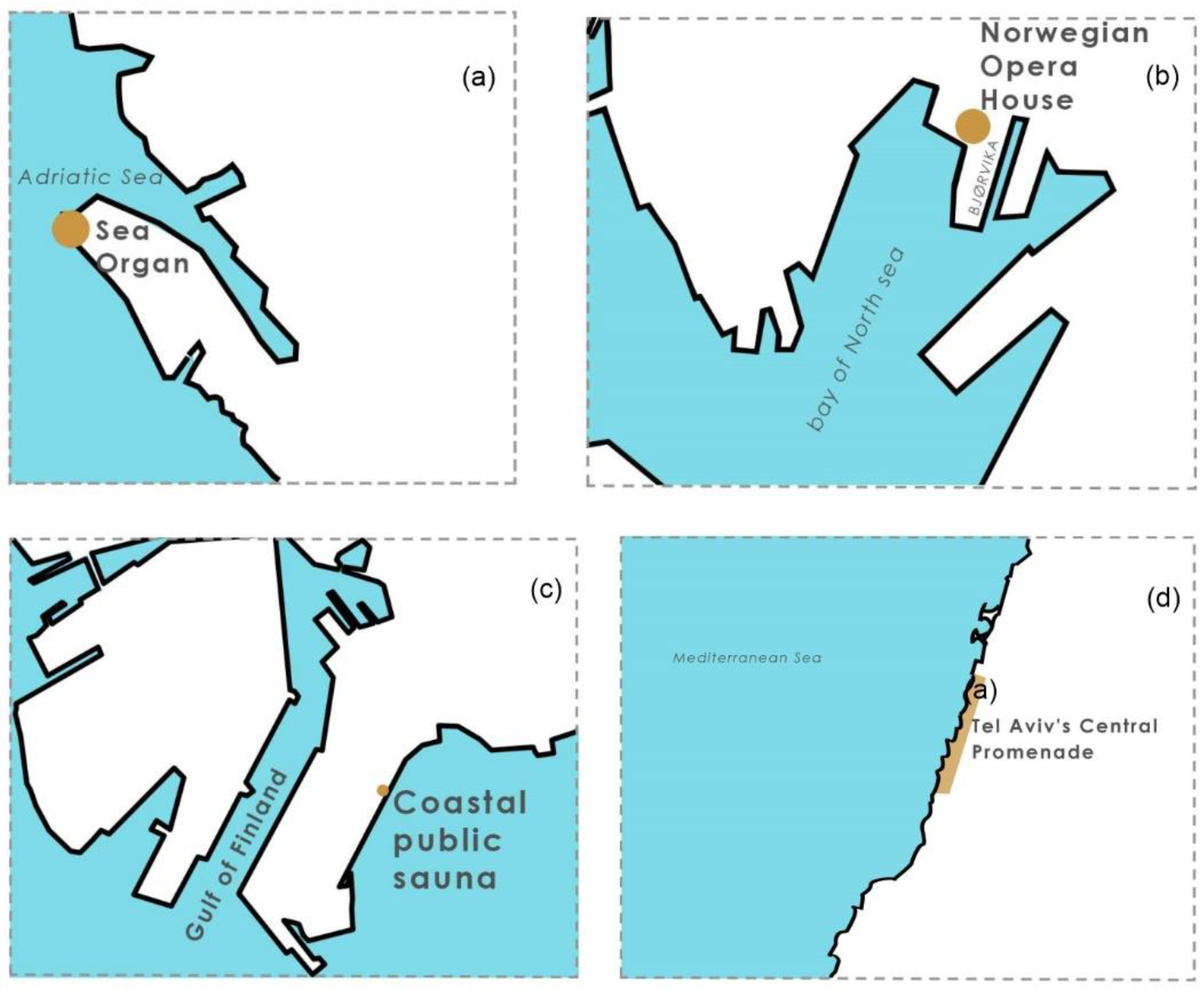
a selection of cases representing a specific group of functional and spatial solutions, defined by Matos Silva [33] as: multifunctional defenses (Tel Aviv’s Central Promenade), breakwaters (Coastal public sauna in Helsinki), and embankments (Sea Organs Zadar). To this group of functional and spatial solutions, the “wharf” type has been added, which is exemplified in this work by the case of the National Opera and Ballet in Oslo.
The case studies are presented in chronological order and discussed in detail as follows:
-
analysis of the location and urban context and collection of basic data on investments;
-
analysis of the features of the urban and architectural design affecting the land–water relationship, presented in graphic form (plan and cross-section) and qualitative description;
-
defining the type of land–water edge and the degree of its permeability using the existing typologies [2,35].
In relation to waterfronts the concept of “porosity” is defined as the discontinuity of boundaries of structures (e.g., walls, building frontages, rows of trees) surrounding and shaping the edges of urban blue public spaces [2]. While the “permeability” of the waterfront is understood as an ability of water to penetrate and flood the structure situated on the land–water edge, partially or fully, this results in the occurrence of a transition zone of a specific wide existing in between the two environments, instead of a sharp-contact land–water edge. Therefore, as the second concept refers to the land–water edge, which is the focus of this research, in this work the term “permeability” is used.
According to Dal Cin et al. [35] after [55] there are four different strategies that might be undertaken while designing waterfront structures: adaption, reaction, reduction, prevention. Among the structures for which flooding is anticipated and an adaptive strategy is taken, these authors [35] distinguish: floating and wet-proof structures. The structures that prevent flooding for which a threshold strategy is proposed are: coastal defenses, flood walls and barriers.
This paper concentrates on transformations of the existing waterfronts with a high level of flood risk, which are a component of the seashore protection system, and in terms of the flood strategy presented by Dal Cin et al. [35] they represent the category of “threshold capacity”.
The first typology used for describing the water–land edges occurring in public spaces of waterfronts was the division proposed by Dal Cin et al. [35], which refers to the degree of proximity of the public space of the waterfront to water. Dal Cin et al. [35] distinguished three types of spatial relations:
-
“near the water”, when the public space is situated along the shoreline;
-
“in the water”, in case the public space is amphibious while being flooded;
-
“on the water”, in a situation when the public space is floating.
The last two types are naturally adapting to the water level rise. The first type (“near the water”), most common on waterfronts, is being either not flooded at all or is being fully or partially submerged during the rise of water level. This paper investigated only the “near water” solutions and examined to what extend the designers allow the public space to become flooded.
The typology of the land–water edge, taking into account the characteristics of its cross-section, is presented by Breś and Krośnicka [2]. These authors distinguish between “fixed” or “flexible” edges. The “fixed” edge does not provide direct access to the water for users and does not change its position as the water levels change. Among the fixed type of the water–land edge the authors enumerate “vertical” edges and edges located “over” the water. Both these types of edges are often used as port and urban quays, the elevation of which should be above the flooding level. The edges located above the water can be designed as a slab structure on piles or, less frequently, as a cantilever beam. The flexible edge changes its position with fluctuating water levels and usually gives users direct access to the water. Flexible edges can take various shapes, such as: “sloping” (gently sloping into the water), “slanted” (strongly sloping in relation to the water), “terraced” (stairs going down towards the water) or “floating” (moving along with the water surface). In the case of the second group of solutions (flexible edges), the land–water edge is not a single line, but forms a zone.
The cases of Zadar and Oslo describe the transformation of harbor quays, which before reconstruction represented the “fixed vertical” type of land–water edge. In turn, the cases of Helsinki and Tel Aviv describe respectively the reconstruction of the rubble mound breakwater and the sea shore, i.e., they represent the “flexible slanted” and “flexible sloping” type of land–water edges.
As the comparative study of porosity of waterfronts refers to a relatively small scale of interventions and concerns the scale of architecture and urban design, another approach proposed by [56] was taken to lead the comparative study in this paper. However, some of the indexes connected with the visual connectivity and architectural quality proposed by these authors [56] were also used in this work.

3. Results

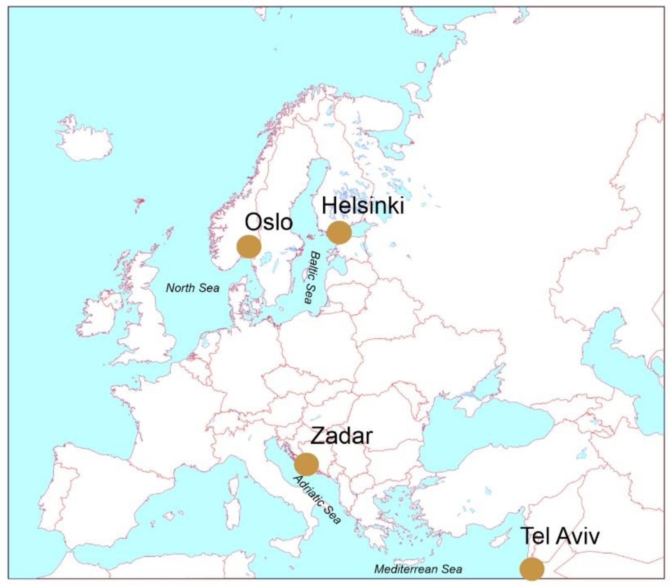
3.1. Study Case Location and Context

The four chosen study cases (Sea Organs in Zadar, Norwegian National Opera and Ballet in Oslo, coastal public sauna in Helsinki, and Tel Aviv’s Central Promenade) are located in Europe and Israel (Figure 1). Two of them, located in the north, experience a temperate climate, and the other two are situated on the Mediterranean sea, having a subtropical climate.
Helsinki, located on the Baltic Sea (Bothnian Bay) struggles with icing in winter, and therefore the architectural solutions located there must take this fact into consideration. The public sauna in Helsinki is situated (Figure 2c) on the artificial shore (previously fulfilling the role of the port’s rubble mound breakwater). Located almost right in the city center, it is a social hub, using the old Finnish tradition of taking a sauna and then bathing in the cold water. The object was used by the city of Helsinki as one of the attractions during the revitalisation and redevelopment process of the former industrial area of Hernesaari (Table 1).
The opera in Oslo is located on the North Sea, where the phenomenon of tides occurs. The tidal range, however, is not very significant there (about 40 cm). The Norwegian Opera House is located in the portside area of Bjørvika district, being a part of the Oslo old town (Figure 2b). Despite the unique context, the plot was cut of the city because of industrial constructions in the XX century. At the beginning of XXI century, the Norwegian Government decided to transform the area into an iconic neighborhood that will focus on culture and from the other side connect the city and fjords.
The Oslo study case was selected for consideration because the solutions used during its implementation in 2008 were considered ground-breaking at that time, and it changed the perception of the public waterside space. Similarly, as in case of Helsinki, the building of the opera in Oslo was used by the municipality as an architectural and cultural icon in the process of revitalisation of the post-port area of Bjørvika (Table 1).
The chronologically oldest project analysed in the paper is the Sea Organs in Zadar, completed in 2005 (Table 1). The town of Zadar is located in Croatia on the coast of the Adriatic Sea (Figure 2a). During the World War II it was heavily destroyed. The process of reconstruction of Zadar after the war was very chaotic. In result, the seafront of the north-western part of the peninsula, where the historical center is located, became a neglected area. Due to the growing tourist popularity of the town, in 2004 the Zadar Port Authority, with the support of the Municipal Government, decided to undertake the reconstruction of that segment of the seafront and equip it as an arrival passenger platform for the cruise ships. That investment, together with the experimental instrument called the Sea Organs, became the crucial point in Zadar’s port and town development. Its aim was to design an attractive, both for tourists and local citizens, blue public space, being a town icon.
The last of the analyzed study cases, the Central promenade in Tel Aviv, runs along the Mediterranean seashore (Figure 2d). Since its inception in the late 1930s, the central beach promenade played a key role in establishing the ever-changing connection between the city and its shore. All previous designed versions of the beach promenade were acting as a border that blocked the natural pedestrian flow between the city and its beach. The new project of the central waterfront, completed in 2015 (Table 1), is eliminating the border between the city and the sea and enables free pedestrian flow from the city to the sandy beach.

3.2. Qualitative Comparative Analysis of Study Cases

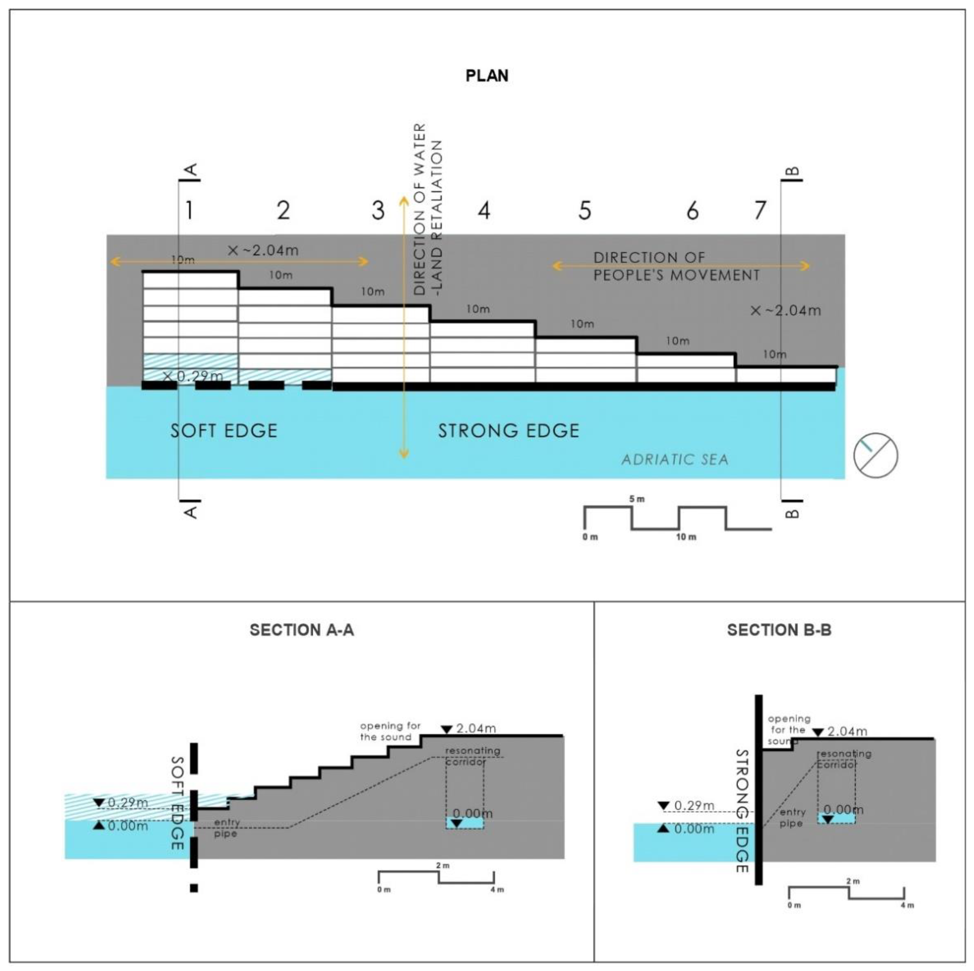
3.2.1. Sea Organs in Zadar (Croatia)

The new arrival passenger platform for the cruise ships equipped with the Sea Organs occupies the far north-western tip of the peninsula (Figure 2a). The continuation of the south-western end of the platform appears in a shape of stairs. The construction of the stairs contains pipes emitting sounds with flowing water and air, that together create the experimental musical instrument [58].
The Organ Stairs are made up of seven parallel flights, each running perpendicular to water. The longest flight, consisting of seven steps, gradually connects the platform with water, overcoming a height of over 2 m. Each next flight is one step shorter and ends one level higher above the sea level. Only the two first flights (the most northern ones) have direct contact with water. Variation in the length of flights, and at the same time of a pipe located under each of a flight, allows one to create variety of sounds. This design approach not only made the Sea Organs an iconic element of the town, but it also mitigated the border between land and water.
The sea organ in Zadar allows different levels of interaction with the water (Figure 3). The first two flights of stairs have a direct connection to the water, which means that the user can have a direct physical contact with the water. The boundary between water and land at this place is changeable (flexible). Successive steps adjacent to the land–sea interface rise up from the water level to the public square level and no longer allow physical contact with the water. However, the terraced layout of the stairs allows access to the water at the lowest point of the Organ and at the same time constitutes a kind of amphitheater that allows passers-by to sit and contemplate the view of the sea. It can therefore be considered that the water–land edge in the case of Sea Organs is flexible and terraced.

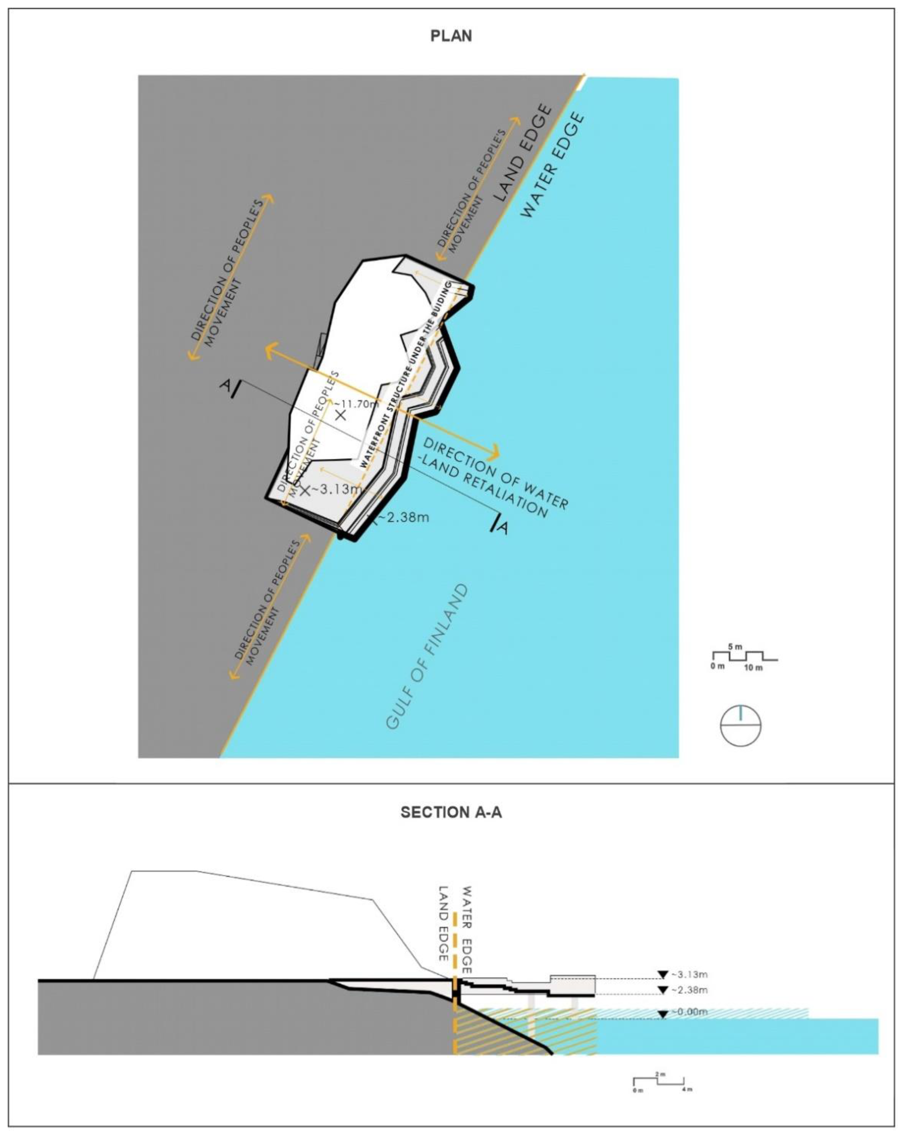
3.2.2. Opera House in Oslo (Norway)

The Opera house has become a part of the city’s revitalization strategy to redevelop the city’s industrial waterfront into an active public space, and thus the Opera House together with the adjacent waterfront public square became an attractive point for the city. Streets around the Opera House have been transformed into pedestrian plazas, which was possible due to redirecting traffic through a new tunnel, the Bjørvika Tunnel completed in 2010, constructed beneath the fjord.
Accessible by means of a pedestrian walkway crossing the adjacent motorway, the roof of the new opera house consists of a series of gently sloping planes covered with white marble cladding [59] that emerge from the waters of the fiord to rise up and cover the concert hall. Due to such a solution, a variety of spaces was created that makes this space multifunctional and give visitors possibilities for experiencing the view of the city and water. The proximity of the water gives visitors also a possibility to interact with water by touching it and experiencing the feeling of being on a beach. A sloped pedestrian roof together with the front square is open all year and it gives the possibility to experience water in each season.
The opera house in Oslo and the adjacent public space are located on a platform that extends into the waters of the fjord and is situated at the base of the former port pier (Figure 4). The slab on which part of the building and the square are located is set on piles. The opera house is connected with the city by a system of pedestrian paths, one of which runs through the bridge connecting the platform with the vertical-walled quay of the former port.
A keystone of the project’s public spaces is the place where the slab is seamlessly merged with the ramps of opera’s roof. The gently descending roof structure serves as a public space and a pedestrian path allowing access to the terraces located at the higher level. Both the terraces and ramps open up a view of the water, the port and the city. The contact zone between the opera’s surroundings and the water on the northern, southern and eastern sides (which play the role of the facility’s maintenance zone) have the character of a fixed edge (vertical quay wall). The representative west side, on the other hand, descends from the level of the main square at a gentle angle into the water and allows passers-by to interact with the rising and falling water, not only through eye contact, but also by touching the water physically. The shape of the public square in front of the opera house refers to the natural slope of the beach. The shape of the square and the direct contact with the water make this space be perceived as an urban park, despite the lack of greenery, what illustrates an approach used recently often in urban design: “blue is green”. The water–land relations of the Opera House in Oslo and the surrounding public spaces have therefore a complex character. Some of the water–land edges, mostly those being a heritage after the port functions, are fixed and vertical (walls of wharfs). The edges of newly introduced spaces are of a mixed type, containing both types: “fixed over water” and “flexible and sloping” (descending gently towards water).

3.2.3. Coastal Public Sauna in Helsinki (Finland)

The Coastal public sauna is located less than two kilometres away from the Helsinki city center, on the Hernesaari peninsula built up on top of land reclaimed from the sea. Hernesaari area has been a hub for the port activities and at the same time functioning as the breakwater protecting the West Harbour. Currently the plot is being redeveloped into a vibrant residential area with a large beach park. The project is an initiative of Helsinki city. A costal public sauna is located in site of Beach Park. The park will be a part of a broader “Helsinki park” connecting the area along the shoreline to the city centre. The building and surroundings of the public sauna in Helsinki are designed to use the entire network of visual connections to the water. The square by the waterside in front of the sauna is equipped with stairs and ladders, with the help of which users can enter the water and take a bath in the sea after using the sauna (Figure 5). So, although there is a possibility of direct contact with the water at this point, the users of the main part of the square are not able to physically touch the water. The large part of the square is situated above the water’s surface, so, the line of the quay’s crown, on which the main pedestrian path is located, is shifted back towards the land in relation to the shoreline. Such a solution is dictated, among other things, by the specific climatic conditions of the Bothnian Bay, including, in particular, the icing of the basin in Winter and the impact of ice on the structure of the facility’s foundations.
It can therefore be concluded that the water–land edge, while redesigning the space of Helsinki public sauna, was changed from “flexible slanted” into “fixed over water” type, being however equipped with a point access to water (the ladder), and offering a variety of views from inside and outside the building.

3.3. Tel Aviv’s Central Promenade Renewal (Israel)

By creating a continuous line of stairs for sitting and a system of ramps all along the waterfront, as well as redesigning the rooftops of the existing beach buildings and turning them into urban balconies, the physical and landscape border between the city and the sea was eliminated, and a unique urban character was given to Tel Aviv’s shoreline. New space between the beach and city, due to the diversity of the public spaces, turned out to be attractive for the new urban culture, where different groups of visitors have a place for meeting, so the promenade has become a common social platform. The Central Promenade Renewal is a deeply transformative project due to its central position in the structure of Tel Aviv and the radical changes it has made in the relation between the city’s-built fabric and the sea.
The central promenade is a zone between the city and the beach. It runs at the level of the city highway, on the roofs of buildings serving the beach one storey below (Figure 6). Although the promenade itself does not have a direct connection to the sea, it is an extension of the beach recreation area towards the city. It is also a transit area, allowing an access to the beach through a system of passages and stairs, and providing a landscape path, which allows visual contact with water from vantage points located at the boulevard level.
The previously existing type of land–water edge of the Tel Aviv waterfront was of a “flexible sloping” type, but from the place where the construction of a retaining wall supporting the road infrastructure was being located, this changed its character into a “fixed vertical”. The new water–land edge is also determined by the shoreline, so its position varies according to the current sea level. It can therefore be classified as a “flexible sloping” edge, as it was before redesigning the waterfront. The “fixed vertical” (strong) edge is still present in this solution, however it was moved from the previous location (a retaining wall) towards the water, where it was hidden in the construction of the view points and coffeehouse, taking a shape of a dune.

4. Discussion

City waterfronts are a very important element of the urban structure. Along with the changes in their functions, they have evolved, usually towards activating them as public spaces. Until recently, when designing waterside areas in cities, solutions analogous to those previously associated with port or industrial functions, i.e., mainly vertical quay walls, were used. Public spaces designed in this way had “strong”, impermeable edges.
In the discussed study cases (Zadar, Oslo, Helsinki, Tel Aviv), the design of the water areas consisted of the integration of land and water spaces and the creation of the so-called urban blue spaces, where water was used as a material for building a public space. The edges of these spaces are “soft” (permeable -they change with the water level) and blur the boundary between water and land, allowing for human–water interactions. The permeability of the edges has been achieved for example by the use of multi-level structures. In the case of the Sea Organ in Zadar, it was a terraced stair structure, which allowed direct access to the water, at the same time creating the form of an urban amphitheatre from which you can observe the events taking place on the water.
A completely different type of solution is a platform placed on an elevated platform above the water level with a building landmark referring to the natural shape of the shore, using the roofs as public spaces with viewpoints (Oslo and Helsinki cases). Such a design may allow direct contact with water, such as the Norwegian Opera in Oslo, or may have no direct contact with water, such as the Helsinki Public Sauna. In both the discussed cases, although the architectural object is an icon for the surrounding urban structure, it is not perceived as an independent element, but it functions and is perceived as a coherent part of the shore landscape together with the surrounding public space and water. In shaping the waterside spaces, an approach that takes into account the principles of landscape architecture and integrating the object into the layout of the shore is extremely important, thanks to which we perceive both the object and the water–land contact zone as more natural, despite its high level of urbanization (the case of the Opera House in Zadar). It is however worth considering how much, thanks to using the multilevel solutions (stairs, terraces or floating objects), it would be possible to introduce greenery to the public spaces. This needs careful research on the selection of appropriate vegetation (in this case, probably halophilic) and the methods of its proper maintenance in public spaces.
The public spaces both in Helsinki and Oslo extend towards the water, extending outside the original shoreline, beyond the borders of the urban zone. Therefore, it is worth considering, how to incorporate the tools provided by Integrated Coastal Zone Management (ICZM) [60] and the maritime sea planning (MSP) [61] into the spatial planning process of waterside public spaces, to make the sea and land areas truly coherent and interactive.
The conducted analyses show that the human–water relationship may have: a direct character (the possibility of physically touching the water), indirect character (the possibility of being in the immediate vicinity of the water), and visual and landscape character (the possibility of observation the water from a distance).
The current design trend is therefore to use various and often mixed types of edges to eliminate the sharp water–land boundary and to differentiate the ways humans inter-act with water. What is interesting is that not all the “fixed” types of land–water edges are impermeable to water. The Sea organs in Zadar allows for partial flooding of the construction (only the lowest steps). The Norwegian National Opera and Ballet in Oslo is also temporarily partially flooded at the lowest parts (the lowest part sloping towards water). Similarly, in case of Tel Aviv’s Central Promenade only the higher part of the structure is not planned for being flooded. Only the case of the Coastal public sauna Löyly in Helsinki do they not foresee flooding of the public space, but it allows for the direct entrance to the water.
In recent years, the paradigm of shaping waterside spaces in cities has changed. Designers resigned from the clear separation of the waterside areas with the vertical wall of the wharf and the creation of a “strong” water–land edge. Instead, they have begun to use multi-level solutions with a high degree of permeability in the water–land relationship. The approach based on the gradation of seaside areas levels made it possible to make the public space more attractive by enabling physical access to water and its interactive use, among others as a bathing beach (Helsinki) or an experimental musical instrument (Zadar). In the characterized projects, the buildings ceased to be ordinary cuboids and began to imitate the shape of the sea shore, so they not only fit better into the landscape, but also made their sloping walls and roofs available for moving on them, becoming important public spaces (Oslo, Helsinki). The interiors of the coastal buildings have begun to become extend functionally integrated with the beach area (Tel Aviv, Helsinki). The case of Tel Aviv also shows that the promenade and seaside buildings can become a place to hide inconvenient urban functions, such as city toilets, or serve as a barrier isolating the beach from the noise of a busy city road.

5. Conclusions

The need to reconstruct the seashore zone in order to adapt to the possibility of sea level rises is nowadays often used to improve the quality of public spaces. Forecasts suggest that water levels will continue to rise significantly beyond 2100. The worst-case scenario is that in 300 years the global water level will rise by an average of more than five meters. Projects for the transformation of water–land interfaces are evolving towards increasing public accessibility and multi-functionality (among others by introducing temporary uses) and the use of multi-level solutions (for example by using roofs and sloping walls of buildings, building the blue public space in a way their surface is gradually descending to the water level, or extends above the water level in the form of platform). This place-making approach has become a new tool for transforming marine port structures in public space of contemporary cities.
Current urban and architectural solutions for waterfronts, both in plans and cross-sections, are currently changing towards the spatial integration of water and land and are allowing us to perceive these two environments as a one coherent public space [30,32,57,62,63,64]. While redesigning the waterfronts, the borderline between land and water becomes more blurred and permeable [32,33], and this causes also a psycho-spatial effects [65]. This increasing permeability of the water–land edge has led to creation of the urban blue public space concept [2].
The paper shows therefore, that the 10 Principles for the Sustainable Development of Urban Waterfront Areas [66] after over 20 years of experience should have been currently revised and developed. Principle 2, ordering to treat waterfronts as a “part of existing urban fabric”, suggests only landscape and functional approach to water (“Water is a part of an urban landscape and should be utilized for specific functions such as waterborne transport, environment and culture”). The 10 principles should include also the protection from flooding and sea level rises, as well as should include the idea of designing waterfronts along with water as an urban blue space.

Author Contributions

A.D.: Resources, Writing—Original draft preparation, Methodology, Investigation, Visualization. A.W.: Writing—Original draft preparation, Investigation, Funding acquisition. K.A.K.: Conceptualization, Investigation, Methodology, Writing—Original draft preparation, Reviewing and Editing, Supervision. All authors have read and agreed to the published version of the manuscript.

Funding

This study was funded by the Gdynia Maritime University, the research project WN/2022/PZ/10 and by the European Union’s Horizon 2020 research and innovation programme under the Maria Skłodowska-Curie grant agreement No. 823901.

Institutional Review Board Statement

Not applicable.

Informed Consent Statement

Not applicable.

Data Availability Statement

Not applicable.

Conflicts of Interest

The authors declare no conflict of interest.

References

  1. Hein, C. Port City Porosity: Boundaries, Flows, and Territories. In Planning for Porosity: Exploring Port City Development through the Lens of Boundaries and Flows. Urban Plan. 2021, 6, 4663. [Google Scholar] [CrossRef]
  2. Breś, J.; Krośnicka, K.A. Evolution of Edges and Porosity of Urban Blue Spaces: A Case Study of Gdańsk. Urban Plan. 2021, 6, 90–104. Available online: https://www.cogitatiopress.com/urbanplanning/article/view/4108/4108 (accessed on 1 May 2022). [CrossRef]
  3. Bird, J. Seaports and Seaport Terminals; Hutchinson University Library: London, UK, 1971. [Google Scholar]
  4. Rodrigue, J.-P.; Comtois, C.; Slack, B. Transportation and spatial cycles: Evidence from maritime systems. J. Transp. Geogr. 1997, 5, 87–98. [Google Scholar] [CrossRef]
  5. Notteboom, T. The adaptive capacity of container ports in an era of mega vessels: The case of upstream seaports Antwerp and Hamburg. J. Transp. Geogr. 2016, 54, 295–309. [Google Scholar] [CrossRef]
  6. Monios, J.; Bergqvist, R. Identifying competitive strategies for each phase of the intermodal terminal life cycle. Res. Transp. Bus. Manag. 2017, 23, 97–105. [Google Scholar] [CrossRef] [Green Version]
  7. Krośnicka, K.A. Migration of container terminals as their natural process of evolution: Case study of Gdańsk and Gdynia ports. J. Transp. Geogr. 2021, 93, 103045. [Google Scholar] [CrossRef]
  8. Hayuth, Y. The port-urban interface: An area in transition. Area 1982, 14, 219–224. [Google Scholar]
  9. Hall, P. Waterfronts: A New Urban Frontier. In Waterfronts a New Frontier for Cities on Water; Institute of Urban and Regional Development, University of California: Berkley, MI, USA, 1993. [Google Scholar]
  10. Hoyle, B.S. The port-city interface: Trends, problems and examples. Geoforum 1989, 20, 429–435. [Google Scholar] [CrossRef]
  11. Hoyle, B. Global and Local Change on the Port-City Waterfront. Geogr. Rev. 2000, 90, 395–417. [Google Scholar] [CrossRef]
  12. Ducruet, C.; Lee, S.W. Waterfront redevelopment and territorial integration in Le Havre (France) and Southampton (UK): Implications for Busan, Korea. Ocean. Policy Res. 2006, 21, 127–156. [Google Scholar]
  13. Bruttomesso, R. City-Port—The Paths and Scenarios of a Winning Strategy; City Port; Marsillo: Venice, Italy, 2007. [Google Scholar]
  14. Lorens, P. Urban waterfront regeneration: Origins of the issue. In New Faces of Harbor Cities; Cambridge Scholars Publishing: Newcastle upon Tyne, UK, 2014. [Google Scholar]
  15. Aouissi, K.B.; Madani, S.; Baptist, V. Morphological Evolution of the Port-City Interface of Algiers (16th Century to the Present). Urban Plan. 2021, 6, 119–135. [Google Scholar] [CrossRef]
  16. Hein, C.; Schubert, D. Resilience and Path Dependence: A Comparative Study of the Port Cities of London, Hamburg, and Philadelphia. J. Urban Hist. 2021, 47, 389–419. [Google Scholar] [CrossRef]
  17. Sairinen, R.; Kumpulainen, S. Assessing social impacts in urban waterfront regeneration. Environ. Impact Assess. Rev. 2006, 26, 120–135. [Google Scholar] [CrossRef]
  18. Szmytkowska, M. Coexistence or Displacement? Historical and contemporary developments of urban waterfronts in Polish cities: The case of the Tri-City conurbation. In Handbook of Waterfront Cities and Urbanism; Mahbubur, R.M., Ed.; Routledge: New York, NY, USA, 2022; pp. 419–437. ISBN 978-1-003-20456-5. [Google Scholar] [CrossRef]
  19. Papatheochari, T.; Coccossis, H. Development of a waterfront regeneration tool to support local decision making in the context of integrated coastal zone management. Ocean Coast. Manag. 2019, 169, 284–295. [Google Scholar] [CrossRef]
  20. Palmer, M.D.; Domingues, C.M.; Slangen, A.B.; Dias, F.B. An ensemble approach to quantify global mean sea-level rise over the 20th century from tide gauge reconstructions. Environ. Res. Lett. 2021, 16, 044043. [Google Scholar] [CrossRef]
  21. Fox-Kemper, B.; Hewitt, H.T.; Xiao, C.; Aðalgeirsdóttir, G.; Drijfhout, S.S.; Edwards, T.L.; Golledge, N.R.; Hemer, M.; Kopp, R.E.; Krinner, G.; et al. Ocean, cryosphere, and sea level change. In Climate Change 2021: The Physical Science Basis. Contribution of Working Group I to the Sixth Assessment Report of the Intergovernmental Panel on Climate Change; Cambridge University Press: Cambridge, UK, 2021. [Google Scholar]
  22. Nerem, R.S. Climate-change-driven accelerated sea-level rise detected in the altimeter era. Proc. Natl. Acad. Sci. USA 2018, 115, 2022–2025. [Google Scholar] [CrossRef] [PubMed] [Green Version]
  23. Oppenheimer, M.; Glavovic, B.; Hinkel, J.; van de Wal, R.; Magnan, A.K.; Abd-Elgawad, A.; Cai, R.; Cifuentes-Jara, M.; DeConto, R.M.; Gosh, T.; et al. Chapter 4: Sea level rise and implications for low lying islands, coasts and communities. In IPCC Special Report on the Ocean and Cryosphere in a Changing Climate; The City of Boston Plans for Adaptation; Cambridge University Press: Cambridge, UK, 2019. Available online: https://www.epa.gov/arc-x/city-boston-plans-adaptation (accessed on 12 February 2022).
  24. Climate Change Adaptation Strategy for the City of Oslo. Available online: http://44mpa.pl/wp-content/uploads/2017/02/Climate-Change-Adaptation-Strategy-for-the-City-of-Oslo-2014-2030.pdf (accessed on 5 April 2022).
  25. Helsinki’s Climate Change Adaptation Policies 2019–2025. Available online: https://www.hel.fi/static/kanslia/Julkaisut/2019/Helsinki-climate-change-adaptation-policies-2019-2025.pdf (accessed on 14 March 2022).
  26. Tel Aviv. Climate Adaptation Action Plan. Available online: https://www.tel-aviv.gov.il/en/Documents/Climate%20Adaptation%20Action%20Plan.pdf (accessed on 24 April 2022).
  27. Vallega, A. Urban waterfront facing integrated coastal management. Ocean Coast. Manag. 2001, 44, 379–410. [Google Scholar] [CrossRef]
  28. Costa, J.P. City, port and infrastructure: Breaking the barriers to integrated waterfront regeneration. NovaTerra 2007, 1, 1–25. [Google Scholar]
  29. Costa, J.P.; De Sousa, J.F.; Silva, M.M.; Nouri, A.S. Climate change adaptation and urbanism: A developing agenda for Lisbon within the twenty-first century. Urban Des. Int. 2013, 19, 77–91. [Google Scholar] [CrossRef] [Green Version]
  30. Brownill, S. Just add water: Waterfront regeneration as a global phenomenon. In The Routledge Companion to Urban Regeneration; Routledge: London, UK, 2013; pp. 45–55. [Google Scholar] [CrossRef]
  31. Hein, C. Port cities and urban waterfronts: How localized planning ignores water as a connector. Wiley Interdiscip. Rev. Water 2016, 3, 419–438. [Google Scholar] [CrossRef] [Green Version]
  32. Matos Silva, M. Public Spaces for Water. A Design Notebook; CRC Press: Boca Raton, FL, USA, 2020; ISBN 9780367031008. [Google Scholar]
  33. Silva, M.M.; Costa, J.P. Urban Floods and Climate Change Adaptation: The Potential of Public Space Design When Accommodating Natural Processes. Water 2018, 10, 180. [Google Scholar] [CrossRef] [Green Version]
  34. Storbjörk, S.; Hjerpe, M. Climate-proofing coastal cities: What is needed to go from envisioning to enacting multifunctional solutions for waterfront climate adaptation? Ocean Coast. Manag. 2021, 210, 105732. [Google Scholar] [CrossRef]
  35. Cin, F.D.; Hooimeijer, F.; Silva, M.M. Planning the Urban Waterfront Transformation, from Infrastructures to Public Space Design in a Sea-Level Rise Scenario: The European Union Prize for Contemporary Architecture Case. Water 2021, 13, 218. [Google Scholar] [CrossRef]
  36. Völker, S.; Kistemann, T. The impact of blue space on human health and well-being—Salutogenetic health effects of inland surface waters: A review. Int. J. Hyg. Environ. Health 2011, 12, 449–460. [Google Scholar] [CrossRef] [PubMed]
  37. Völker, S.; Matros, J.; Claßen, T. Determining urban open spaces for health-related appropriations: A qualitative analysis on the significance of blue space. Environ. Earth Sci. 2016, 75, 10–67. [Google Scholar] [CrossRef]
  38. Harteveld, M. “Mapping Maritime Mindsets: Mental Maps.” PortCityFutures (Blog). 10 July 2022. Available online: https://www.portcityfutures.nl/news/mapping-maritime-mindsets-mental-maps (accessed on 10 July 2022).
  39. Kowalewski, M. Images and Spaces of Port Cities in Transition. Space Cult. 2018, 24, 53–65. [Google Scholar] [CrossRef]
  40. Meyer, H. New Arrangements of Ports, Cities and Water—Landscapes. In City-Port; Marsilio: Venice, Italy, 2007; pp. 31–35. [Google Scholar]
  41. Nyka, L. From structures to landscapes—Towards re-conceptualization of the urban condition. Archit. Res. Addressing Soc. Chall. 2017, 1, 509–515. [Google Scholar] [CrossRef]
  42. Moretti, B. The urban-port threshold: Models and strategies. In (Co)habitation Tactics: Imagining Future Spaces in Architecture, City and Landscape; POLIS University: Tirana, Albania, 2018; pp. 535–543. [Google Scholar]
  43. Sánchez, J.M.P.; Daamen, T.A. Using heritage to develop sustainable port-city relationships: Lisbon’s shift from object-based to landscape approaches. In Adaptive Strategies for Water Heritage: Past, Present and Future; Springer: Berlin/Heidelberg, Germany, 2020; pp. 383–399. [Google Scholar] [CrossRef] [Green Version]
  44. Sanches, J. “The Port and the City. Thoughts on the Relations between Cities and Ports.” (Blog). 13 July 2022. Available online: https://theportandthecity.wordpress.com/author/jose23sanchez/ (accessed on 13 July 2022).
  45. Public Space. Norwegian Opera House. Available online: https://www.publicspace.org/works/-/project/f171-den-norske-opera-ballett (accessed on 9 April 2022).
  46. ArchDaily. Oslo Opera House/Snøhetta. Available online: https://www.archdaily.com/440/oslo-opera-house-snohetta (accessed on 24 April 2022).
  47. Dezeen. Avanto Architects. Costal Sauna Helsinki. Available online: https://www.dezeen.com/2016/06/30/avanto-architects-loyly-coastal-sauna-helsinki-faceted-timber-cloak (accessed on 24 April 2022).
  48. City Planning Department. City of Helsinki. Hernesaari. 2001. Available online: https://www.hel.fi/hel2/ksv/julkaisut/esitteet/esite_2011-8_en.pdf (accessed on 24 April 2022).
  49. ArchDaily. Tel Aviv’s Central Promenade Renewal. Available online: https://www.archdaily.com/913023/tel-avivs-central-promenade-renewal-mayslits-kassif-architects (accessed on 26 April 2022).
  50. Public Space. Sea Organ. Available online: https://www.publicspace.org/works/-/project/d078-morske-orgulje (accessed on 9 April 2022).
  51. Krvavica, N.; Ružić, I.; Ožanić, N. Integrated Computational Model for the Sea Organ Simulation. Available online: https://www.researchgate.net/publication/325793979_Integrated_computational_model_for_the_Sea_Organ_simulation (accessed on 9 April 2022).
  52. Taufen-Wessells, A. Urban Blue Space and The Project of the Century: Doing Justice on the Seattle Waterfront and for Local Residents. Buildings 2014, 4, 764784. [Google Scholar]
  53. Garcia, P.R. The Lisbon Waterfront: Perspectives on Resilience in the Transition from the Twentieth to the Twenty-First Century. J. Urban Hist. 2019, 47, 373–388. [Google Scholar] [CrossRef]
  54. Breen, A.; Rigby, D. Waterfront. Cities Relation Their Edge; McGraw Hill: New York, NY, USA, 1994. [Google Scholar]
  55. De Graaf, R.E. Innovations in Urban Water Management to Reduce the Vulnerability of Cities. Ph.D. Thesis, Delft University of Technology, Delft, The Netherlands, 2009. [Google Scholar]
  56. Andrade, M.J.; Costa, J.P.; López, J.B. 3DPortCityMeasure: Methodology for the Comparative Study of Good Practices in Port–City Integration. Sustainability 2020, 12, 880. [Google Scholar] [CrossRef] [Green Version]
  57. Landezine-Award. Tel Aviv’s Central Promenade Renewal. Available online: https://landezine-award.com/tel-avivs-central-promenade-renewal/ (accessed on 26 April 2022).
  58. Krvavica, N.; Peroli, G.; Ružić, I.; Ožanić, N. Time-dependent numerical model for simulating internal oscillations in a sea organ. Ocean Eng. 2020, 205, 107336. [Google Scholar] [CrossRef] [Green Version]
  59. Gherardi, F.; Kapridaki, C.; Roveri, M.; Gulotta, D.; Maravelaki, P.N.; Toniolo, L. The deterioration of Apuan white marble in contemporary architectural context. J. Cult. Heritage 2018, 35, 297–306. [Google Scholar] [CrossRef]
  60. Directive 2014/89/EU establishing a framework for maritime spatial planning, Brussels, 3.5.2022 COM(2022) 185 final. Available online: https://maritime-spatial-planning.ec.europa.eu/sites/default/files/com2022185_0.pdf (accessed on 11 July 2022).
  61. EU Initiative on Maritime Spatial Planning and Integrated Coastal Management. 2 March 2013. Available online: https://eur-lex.europa.eu/LexUriServ/LexUriServ.do?uri=COM%3A2013%3A0133%3AFIN%3AEN%3AHTML (accessed on 12 July 2022).
  62. Burda, I.M.; Nyka, L. Providing Public Space Continuities in Post-Industrial Areas through Remodelling Land/Water Connections. IOP Conf. Series Mater. Sci. Eng. 2017, 245, 082037. [Google Scholar] [CrossRef]
  63. Brand, D. Bluespace: A typological matrix for port cities. Urban Des. Int. 2007, 12, 69–85. [Google Scholar] [CrossRef]
  64. Britton, E.; Kindermann, G.; Domegan, C.; Carlin, C. Blue care: A systematic review of blue space interventions for health and wellbeing. Health Promot. Int. 2018, 35, 50–69. [Google Scholar] [CrossRef] [Green Version]
  65. Ioannidis, K. Designing the Edge: An Inquiry into the Psychospatial Nature of Meaning in the Architecture of the Urban Waterfront. Ph.D. Thesis, KTH Royal Institute of Technology, Stockholm, Sweden, 2011. [Google Scholar]
  66. Principles for Sustainable Development of Urban Waterfront Areas. Cities on Water in collaboration Wasserstadt GmbH, Berlin. In Proceedings of the International Seminars: Global Conference on the Urban Future (URBAN 21), EXPO 2000 World Exhibition, Berlin, Germany, 4–6 July 2000.
Figure 1. Location of the case studies in Europe. Source: own based on https://commons.wikimedia.org/wiki/File:Europe_political_map.svg (accessed on 29 July 2022).
Sustainability 14 09357 g001
Figure 2. Case studies location on the seashore; (a) Sea Organs in Zadar (Croatia); (b) Norwegian Opera House in Oslo (Norway); (c) Coastal public sauna in Helsinki (Finland); (d) Central Promenade in Tel Aviv (Israel). Source: own.
Sustainability 14 09357 g002
Figure 3. Sea Organs in Zadar—plan, section A-A, section B-B. Source: own.
Sustainability 14 09357 g003
Figure 4. Opera House in Oslo—plan and section A-A. Source: own.
Sustainability 14 09357 g004
Figure 5. Coastal public sauna in Helsinki—plan and section A-A. Source: own.
Sustainability 14 09357 g005
Figure 6. Central Promenade Renewal in Tel Aviv—plan and section A-A. Source: own.
Sustainability 14 09357 g006
Table 1. Basic information about the studied projects elaborated on the basis of: [45,46,47,48,49,50,51,57].
Project NameAuthorsDevelopersYear of Beginning and CompletionArea [m²]Cost [€]
Sea organs in Zadar (Croatia)Nikola Bašić, collaborators: I. Stamać, V. Andročec, T. HefererPort of Zadar, Municipality of Zadar; public order2004–20051700 m²240,000
Opera house in Oslo (Norway)SNØHETTA, collaborators: Kristian Blystad, Kalle Grude, Jorunn Sannes, Astrid Løvaas, Kirsten WagleSTATSBYGG (Norwegian government’s building commissioner, property manager and developer); public order2000–200838,500 m²500,000,000
Coastal public sauna in Helsinki (Finland)Avanto Architects, Ville Hara and Anu Puustinen, Architects SAFA, Antti Westerlund, Hiroko Mori, Laura Nenonen, Xiaowen Xu, Joanna Laajisto Creative Studio (interiors)Member of Parliament Antero Vartia and Jasper Pääkkönen, Kidvekkeli Oy (funding from Helsinki city; public order2011–20161071 m²6,000,000
Tel Aviv’s Central Promenade Renewal (Israel)Mayslits Kassif Architects, Ganit Mayslits Kassif, Udi Mayslits Kassif, Maor Roytman-2006–2015--
Publisher’s Note: MDPI stays neutral with regard to jurisdictional claims in published maps and institutional affiliations.

