
The Legibility Efficacy of Historical Neighborhoods in Creating a Cognitive Map for Citizens


Abstract
1. Introduction
- Is there a significant correlation between spatial legibility and creating a cognitive map for citizens in historical neighborhoods of Lahijan city?
- What is the level of legibility of the studied areas according to their spatial configuration?
- What are the most important criteria and sub-criteria for legibility and the formation of a suitable cognitive map in urban spaces from the perspective of Lahijan inhabitants?
2. Literature Review
Legibility and Its Role on the Creation of Cognitive Maps in Urban Spaces
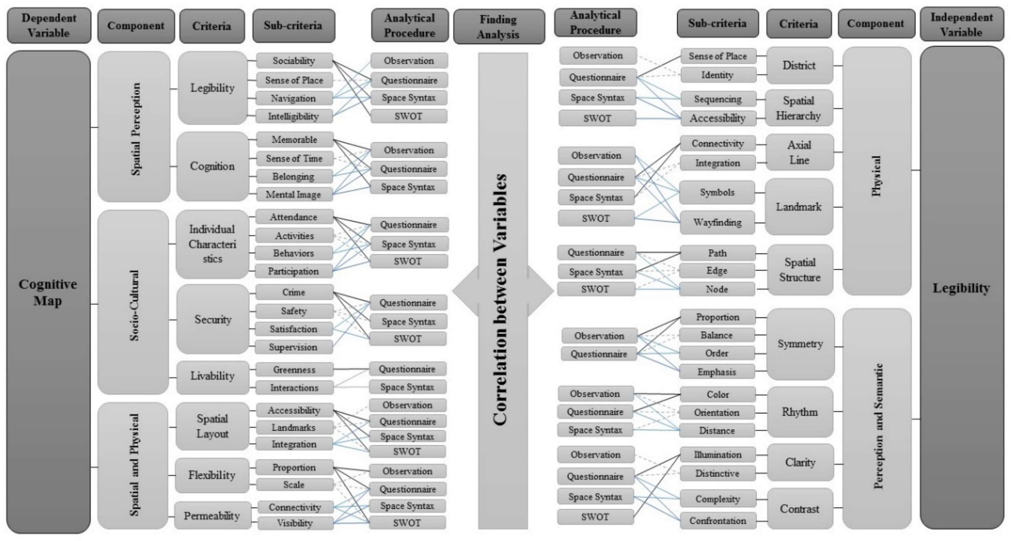
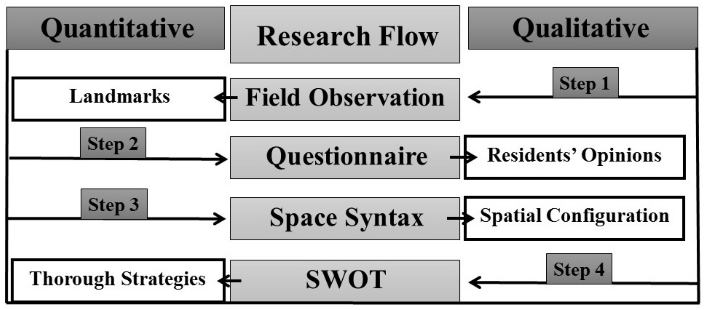
3. Research Methodology
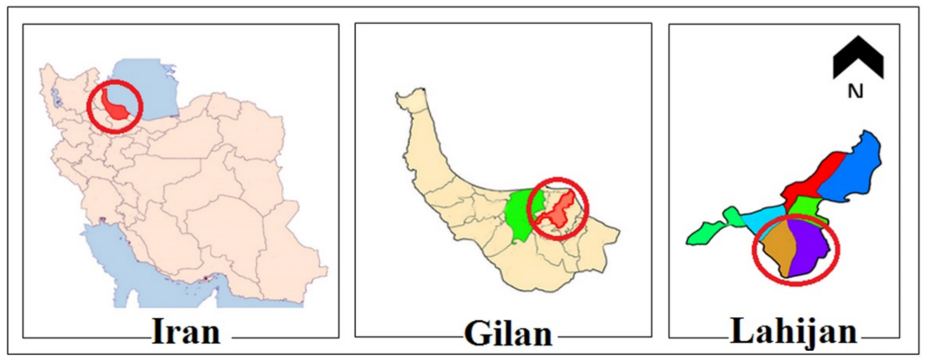
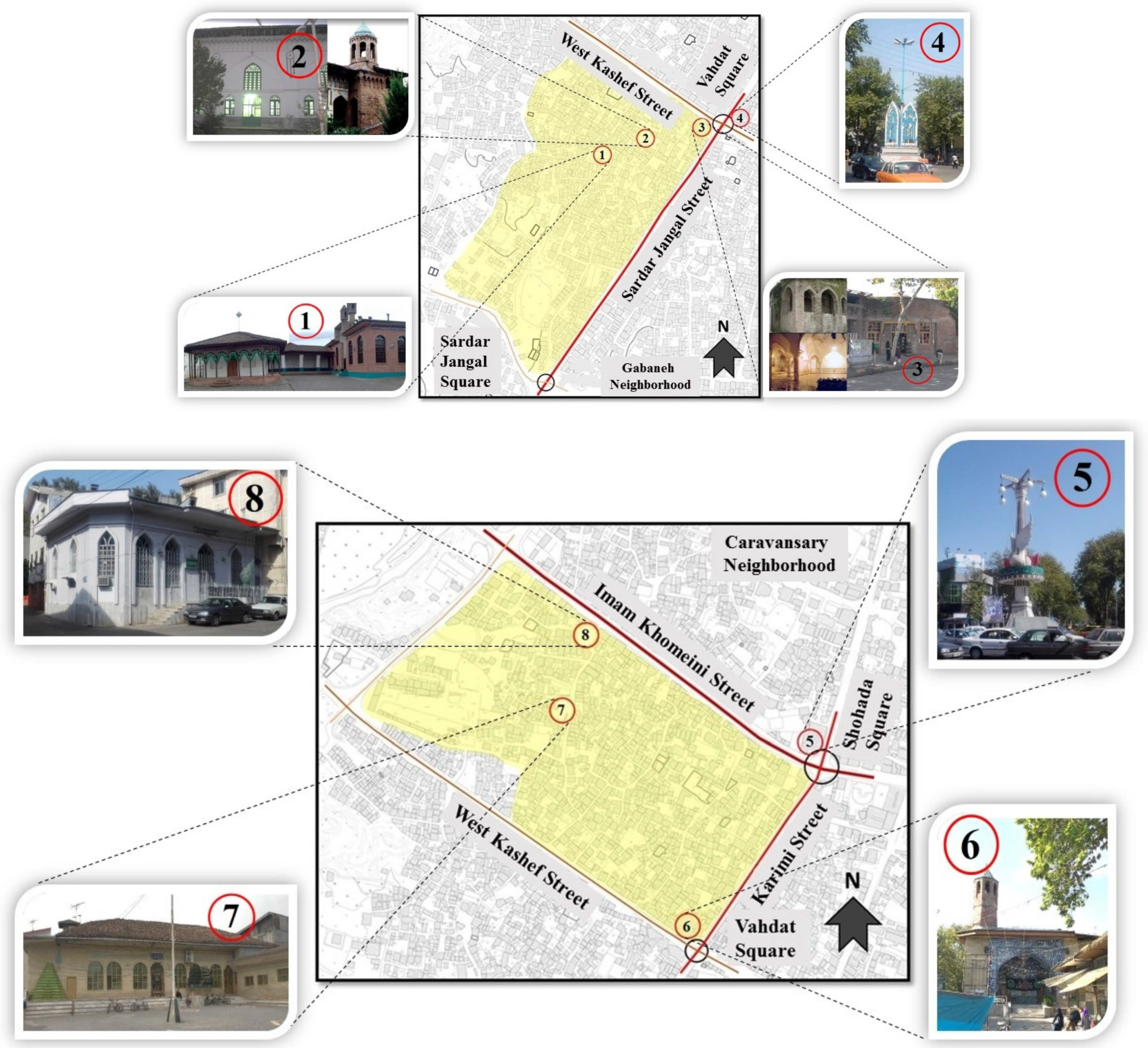
Study Areas
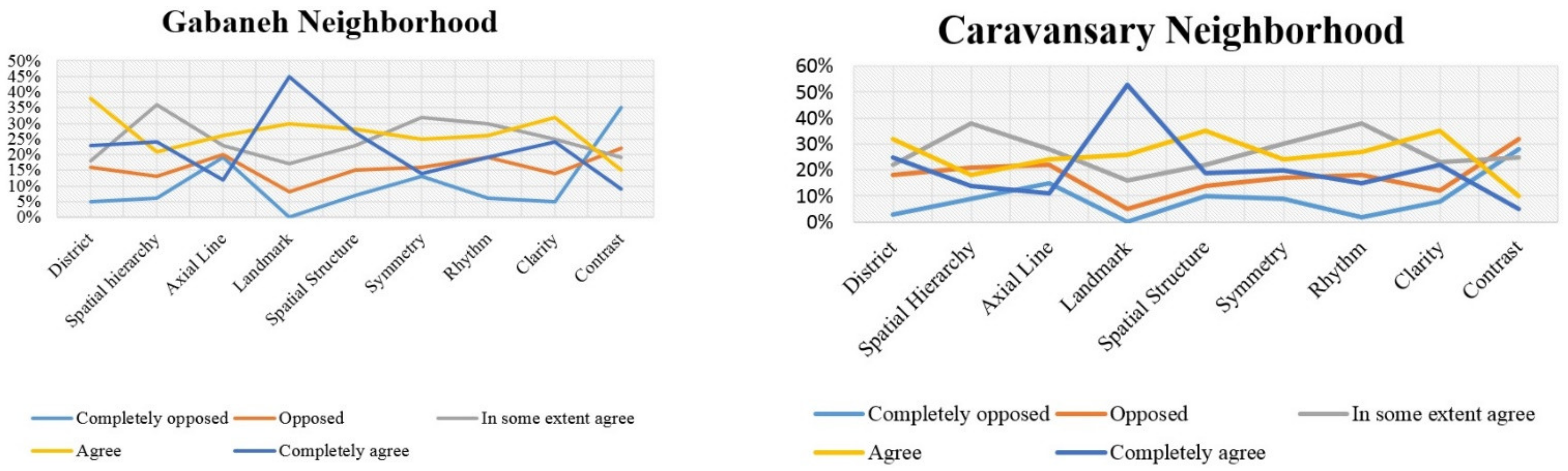
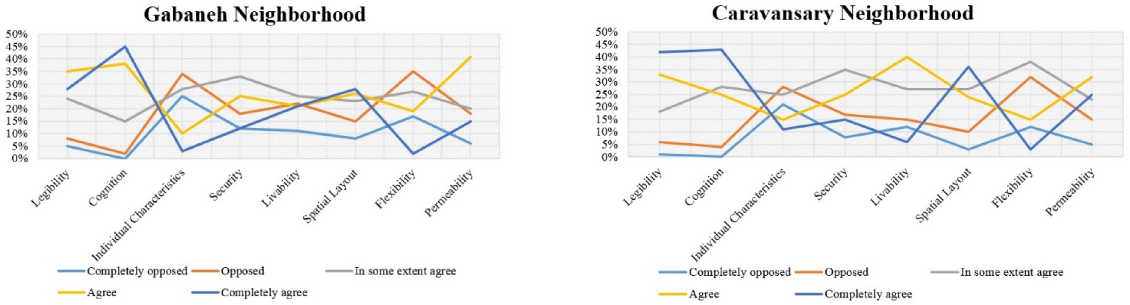
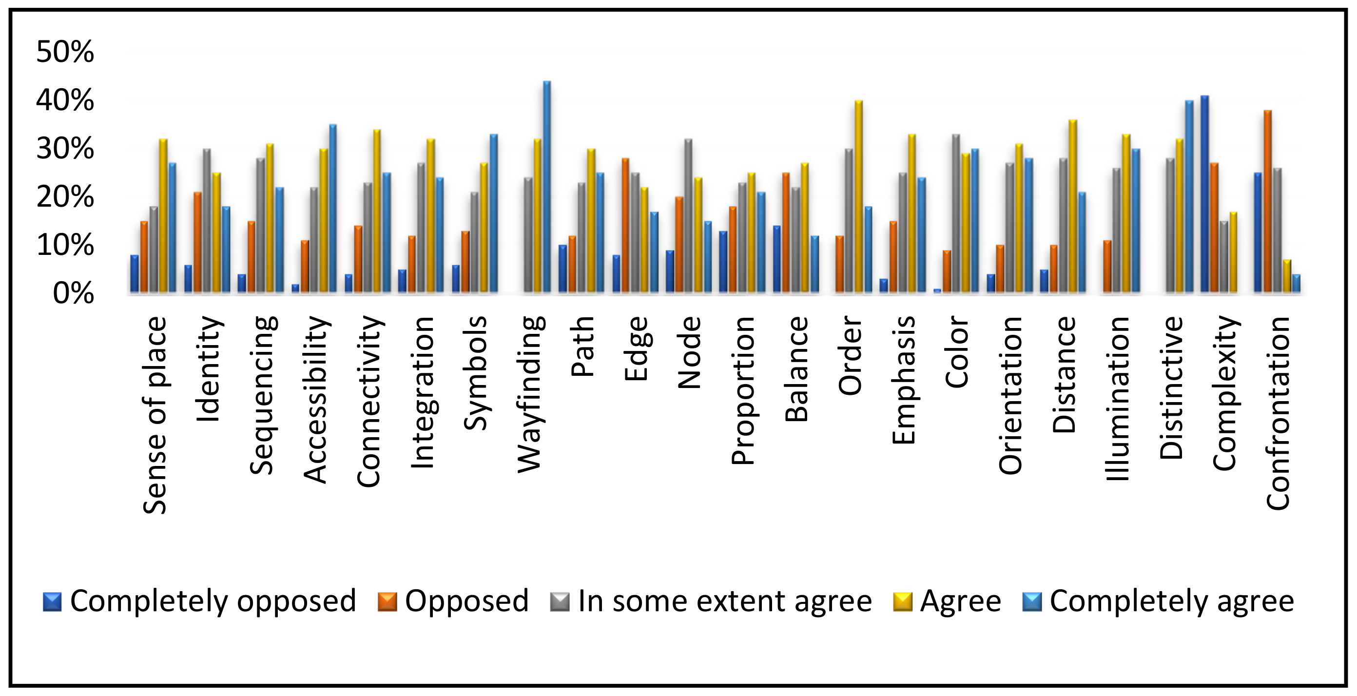
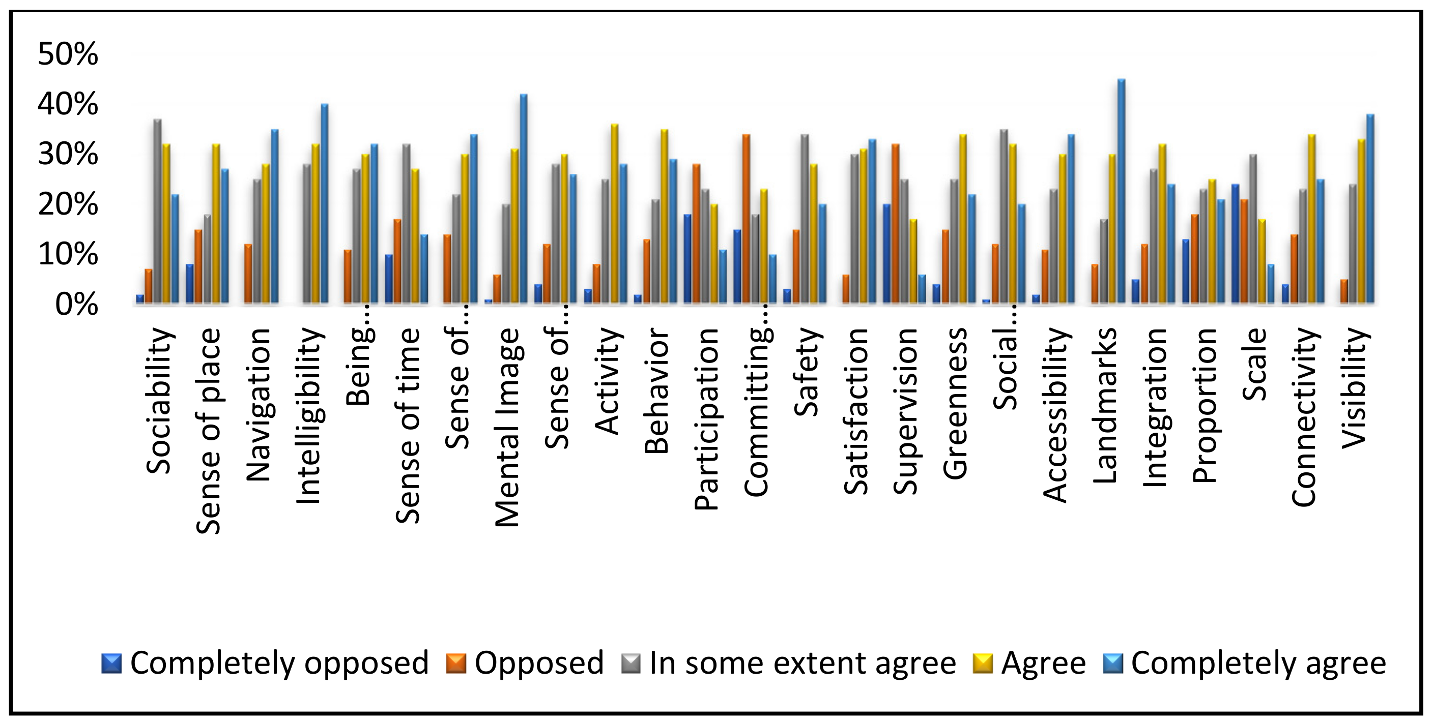
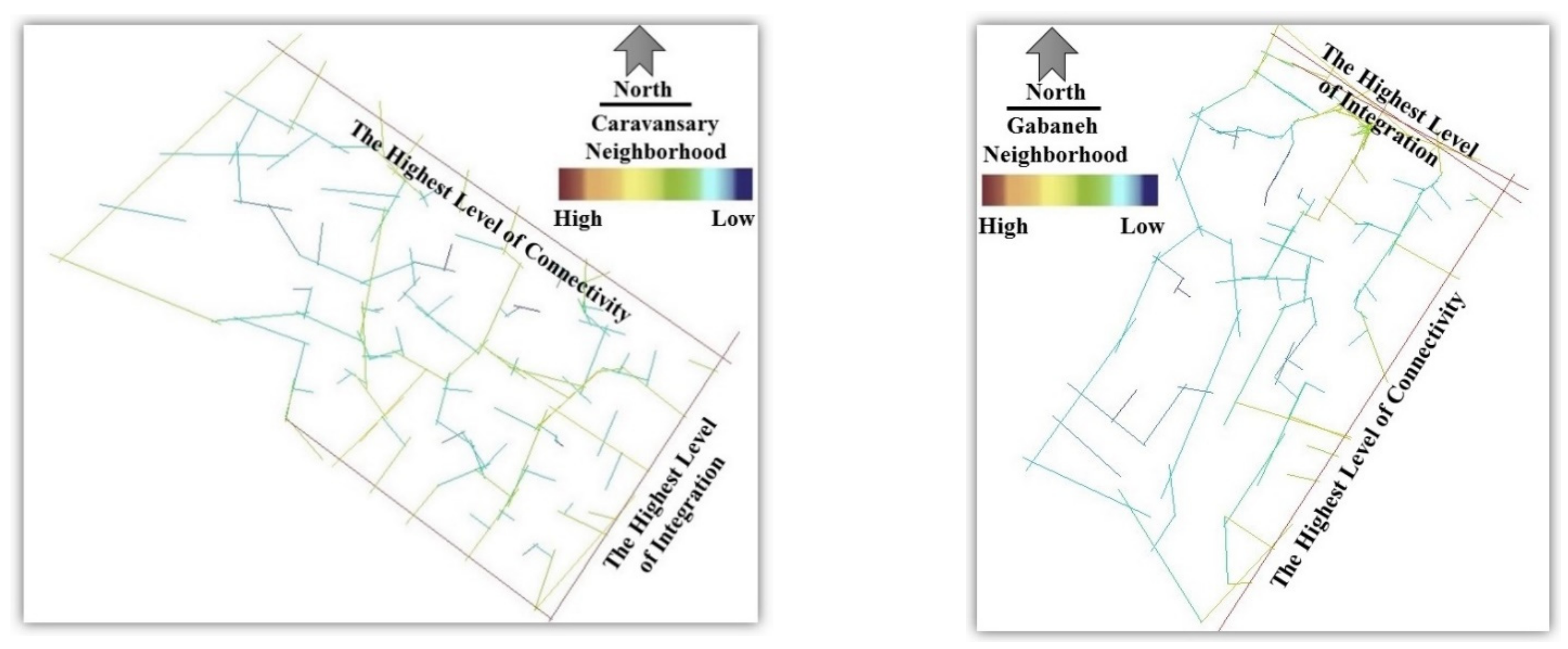
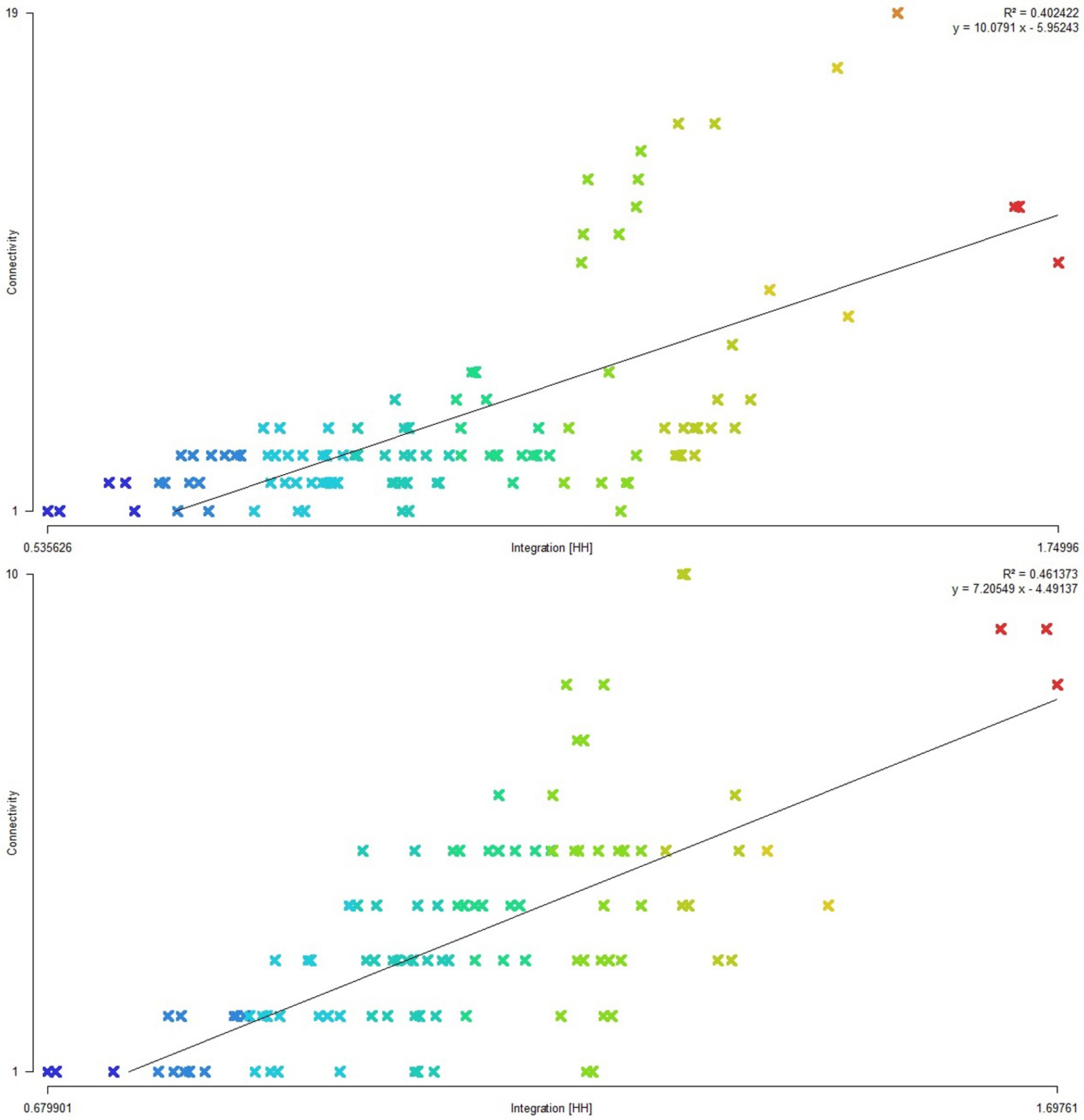
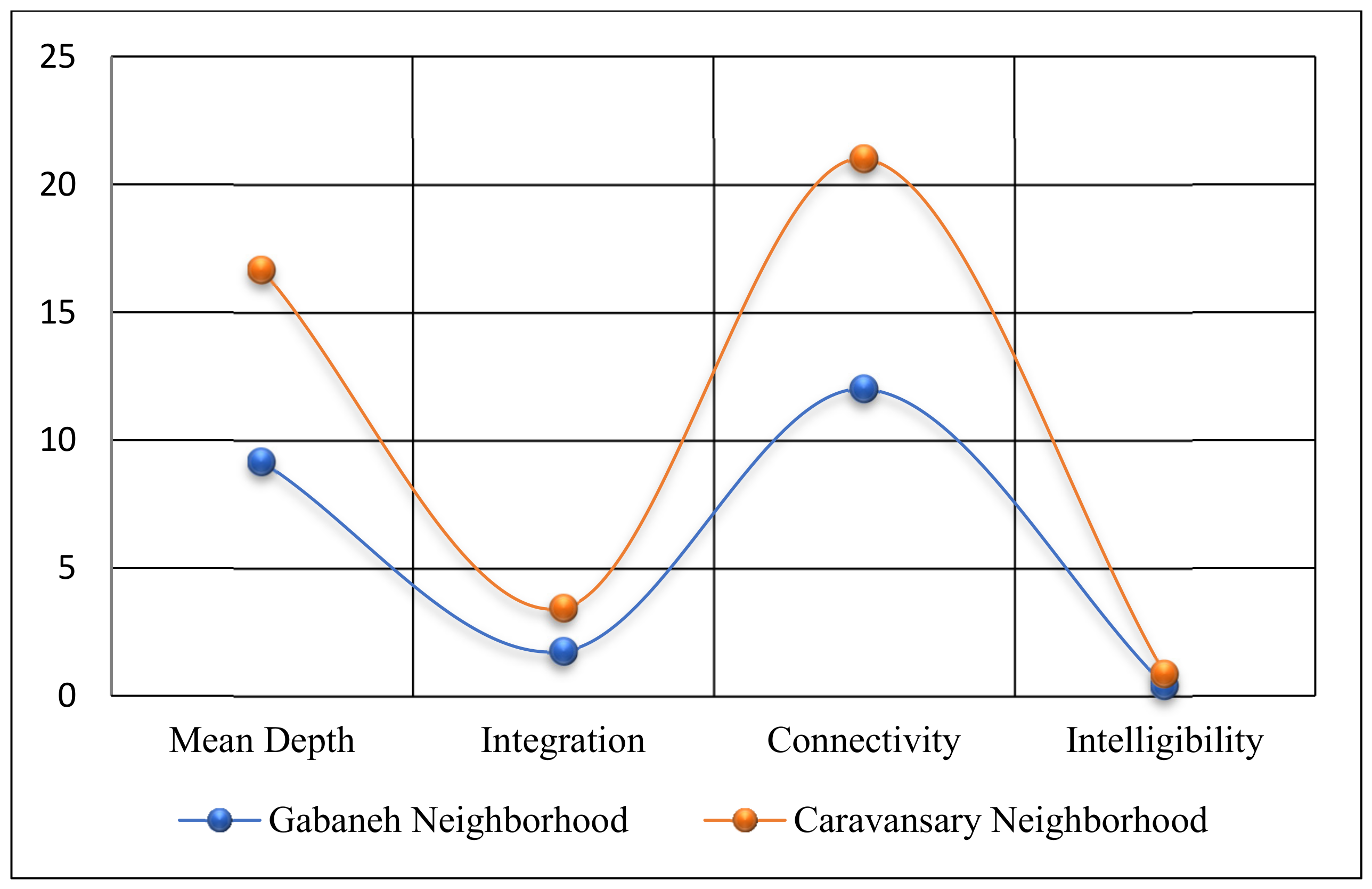
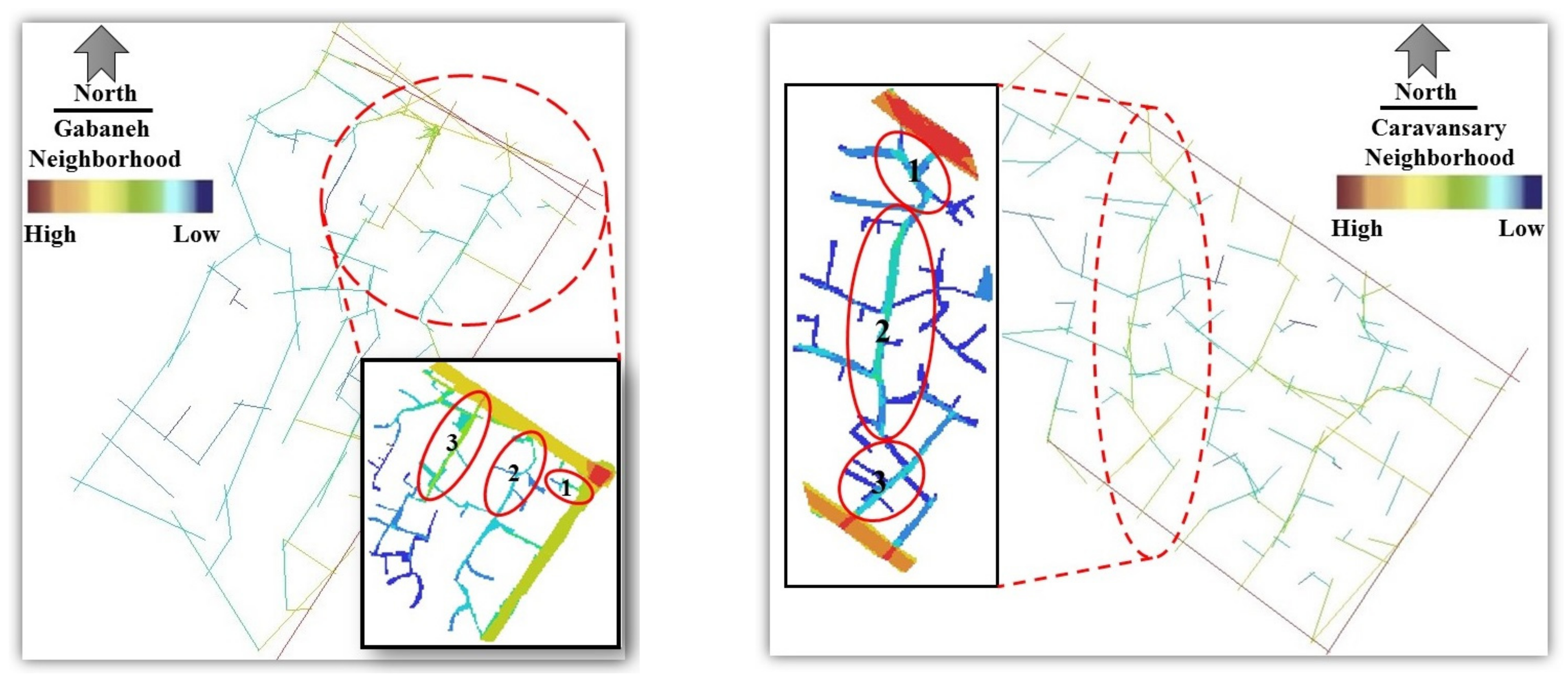
4. Results
5. Discussion
6. Conclusions
Author Contributions
Funding
Institutional Review Board Statement
Informed Consent Statement
Data Availability Statement
Conflicts of Interest
References
- Pinheiro, J. Determinants of Cognitive Maps of the World as Expressed in Sketch Maps. J. Environ. Psychol. 1998, 18, 321–339. [Google Scholar] [CrossRef][Green Version]
- Shepard, R.N. The mental image. Am. Psychol. 1978, 33, 125–137. [Google Scholar] [CrossRef]
- Iachini, T.; Maffei, L.; Masullo, M.; Senese, V.P.; Rapuano, M.; Pascale, A.; Ruggiero, G. The experience of virtual reality: Are individual differences in mental imagery associated with sense of presence? Cogn. Process. 2019, 20, 291–298. [Google Scholar] [CrossRef] [PubMed]
- Passini, R.; Proulx, G.; Rainville, C. The Spatio-Cognitive Abilities of the Visually Impaired Population. Environ. Behav. 1990, 22, 91–118. [Google Scholar] [CrossRef]
- Isaac, A.; Marks, D. Individual differences in mental imagery experience: Developmental changes and specialization. Br. J. Psychol. 1994, 85, 479–500. [Google Scholar] [CrossRef]
- Kosslyn, S.; Brunn, J.; Cave, K.; Wallach, R. Individual differences in mental imagery ability: A computational analysis. Cognition 1984, 18, 195–243. [Google Scholar] [CrossRef]
- Phillips, I. Lack of imagination: Individual differences in mental imagery and the significance of consciousness. In New Waves in Philosophy of Mind; Kallestrup, J., Sprevak, M., Eds.; Palgrave Macmillan: London, UK, 2014; p. 278. [Google Scholar] [CrossRef]
- Boyer, C. The City of Collective Memory: Its Historical Imagery and Architectural Entertainments; MIT Press: Cambridge, MA, USA, 1996. [Google Scholar]
- Pallasmaa, J. The Embodied Image: Imaginations and Imagery in Architecture; Wiley: London, UK, 2011. [Google Scholar]
- Bruns, C.; Chamberlain, B. The influence of landmarks and urban form on cognitive maps using virtual reality. Landsc. Urban Plan. 2019, 189, 296–306. [Google Scholar] [CrossRef]
- Asadpour, A.; Faizi, M.; Mozaaffar, F.; Behzadfar, M. Typology of models and comparative study of methods in recording mental images and cognitive maps from the environment. Mon. Sci. J. Bagh-E Nazar 2015, 12, 13–22. [Google Scholar]
- Herzog, T.R.; Leverich, O.L. Searching for Legibility. Environ. Behav. 2003, 35, 459–477. [Google Scholar] [CrossRef]
- Filomena, G.; Verstegen, J. Modelling the effect of landmarks on pedestrian dynamics in urban environments. Computers. Environ. Urban Syst. 2021, 86, 101573. [Google Scholar] [CrossRef]
- Zhao, Z.; Ren, J.; Wen, Y. Spatial Perception of Urban Forests by Citizens Based on Semantic Differences and Cognitive Maps. Forests 2019, 11, 64. [Google Scholar] [CrossRef]
- Kang, M.; Liu, Y.; Wang, M.; Li, L.; Weng, M. A random forest classifier with cost-sensitive learning to extract urban landmarks from an imbalanced dataset. Int. J. Geogr. Inf. Sci. 2022, 36, 496–513. [Google Scholar] [CrossRef]
- Zhao, L.; Lu, Y.; Wang, B.; Chau, B.; Zhang, L. Cultivating the sense of belonging and motivating user participation in virtual communities: A social capital perspective. Int. J. Inf. Manag. 2012, 32, 574–588. [Google Scholar] [CrossRef]
- Nanay, B. Multimodal mental imagery. Cortex 2018, 105, 125–134. [Google Scholar] [CrossRef]
- Hamburger, K.; Knauff, M. Odors Can Serve as Landmarks in Human Wayfinding. Cogn. Sci. Multidiscip. J. 2019, 43, e12798. [Google Scholar] [CrossRef]
- Canter, D.; Tagg, S. Distance estimation in cities. Environ. Behav. 1975, 7, 59–80. [Google Scholar] [CrossRef]
- Evans, G.W.; Skorpanich, M.; Garling, T.; Bryant, K.; Bresolin, B. The effects of pathway configuration, landmarks and stress on environmental cognition. J. Environ. Psychol. 1984, 4, 323–335. [Google Scholar] [CrossRef]
- Mondschein, A.; Moga, S.T. New Directions in Cognitive-Environmental Research. J. Am. Plan. Assoc. 2018, 84, 263–275. [Google Scholar] [CrossRef]
- Hollander, J.B.; Purdy, A.; Wiley, A.; Foster, V.; Jacob, R.J.K.; Taylor, H.A.; Brunye, T.T. Seeing the city: Using eye-tracking technology to explore cognitive responses to the built environment. J. Urban. Int. Res. Placemak. Urban Sustain. 2019, 12, 156–171. [Google Scholar] [CrossRef]
- Ahmadpoor, N.; Smith, A.D.; Heath, T. Rethinking legibility in the era of digital mobile maps: An empirical study. J. Urban Des. 2021, 26, 296–318. [Google Scholar] [CrossRef]
- Imani, F.; Tabaeian, M. Recreating mental image with the aid of cognitive maps and its role in environmental perception. Procedia Soc. Behav. Sci. 2012, 32, 53–62. [Google Scholar] [CrossRef]
- Kitchin, R. Cognitive maps: What are they and why study them? J. Environ. Psychol. 1994, 14, 1–19. [Google Scholar] [CrossRef]
- Manley, E.; Filomena, G.; Mavros, P. A spatial model of cognitive distance in cities. Int. J. Geogr. Inf. Sci. 2021, 35, 2316–2338. [Google Scholar] [CrossRef]
- Kozlowski, L.T.; Bryant, K.J. Sense of direction, spatial orientation, and cognitive maps. J. Exp. Psychol. Hum. Percept. Perform. 1997, 3, 590–598. [Google Scholar] [CrossRef]
- Esposito, D.; Santoro, S.; Camarda, D. Agent-Based Analysis of Urban Spaces Using Space Syntax and Spatial Cognition Approaches: A Case Study in Bari, Italy. Sustainability 2020, 12, 4625. [Google Scholar] [CrossRef]
- Erem, O. Revealing recreational settlement image from tourist sketch maps: A mediterranean holiday village. Asia Pac. J. Tour. Res. 2021, 26, 685–701. [Google Scholar] [CrossRef]
- Liu, B.; Li, Y.; Kralj, A.; Moyle, B.; He, M. Inspiration and wellness tourism: The role of cognitive appraisal. J. Travel Tour. Mark. 2022, 39, 173–187. [Google Scholar] [CrossRef]
- Koseoglu, E.; Onder, D. Subjective and objective dimensions of spatial legibility. Procedia Soc. Behav. Sci. 2011, 30, 1191–1195. [Google Scholar] [CrossRef]
- Lloyd, R.; Heivly, C. Systematic Distortions in Urban Cognitive Maps. Ann. Assoc. Am. Geogr. 1987, 77, 191–207. [Google Scholar] [CrossRef]
- Lloyd, R. Cognitive Maps: Encoding and Decoding Information. Ann. Assoc. Am. Geogr. 1989, 79, 101–124. [Google Scholar] [CrossRef]
- Tversky, B. Distortions in cognitive maps. Geoforum 1992, 23, 131–138. [Google Scholar] [CrossRef]
- Kaplan, S. Cognitive maps in perception and thought. In Image and Environment: Cognitive Mapping and Spatial Behavior; Downs, R.M., Stea, D., Eds.; Aldine Publishing Company: Chicago, IL, USA, 1973. [Google Scholar]
- Lynch, K. A Theory of Good City Form; MIT Press: Cambridge, MA, USA, 1981. [Google Scholar]
- Lynch, K. The Image of the City; MIT Press: Cambridge, MA, USA, 1960. [Google Scholar]
- Askarizad, R.; Safari, H.; Pourimanparast, M. The influence of organizing historical textures on citizenry satisfaction in the old texture neighbourhoods of Rasht. Emerg. Sci. J. 2017, 1, 118–128. [Google Scholar] [CrossRef]
- Talen, E. Traditional Urbanism Meets Residential Affluence: An Analysis of the Variability of Suburban Preference. J. Am. Plan. Assoc. 2001, 67, 199–216. [Google Scholar] [CrossRef]
- Hollander, J.B.; Sussman, A.; Levering, A.P.; Foster-Karim, C. Using Eye-Tracking to Understand Human Responses to Traditional Neighborhood Designs. Plan. Pract. Res. 2020, 35, 485–509. [Google Scholar] [CrossRef]
- Ewing, R.; Bartholomew, K. Pedestrian and Transit-Oriented Design; Urban Land Institute and American Planning Association: Washington, DC, USA, 2013. [Google Scholar]
- Long, Y.; Baran, P.K. Does Intelligibility Affect Place Legibility? Understanding the Relationship Between Objective and Subjective Evaluations of the Urban Environment. Environ. Behav. 2012, 44, 616–640. [Google Scholar] [CrossRef]
- Topcu, K.; Topcu, M. Visual Presentation of Mental Images in Urban Design Education: Cognitive Maps. Procedia Soc. Behav. Sci. 2012, 51, 573–582. [Google Scholar] [CrossRef]
- Li, R.; Klippel, A. Wayfinding Behaviors in Complex Buildings: The Impact of Environmental Legibility and Familiarity. Environ. Behav. 2016, 48, 482–510. [Google Scholar] [CrossRef]
- Meenar, M.; Afzalan, N.; Hajrasouliha, A. Analyzing Lynch’s City Imageability in the Digital Age. J. Plan. Educ. Res. 2019. [Google Scholar] [CrossRef]
- Safari, H.; Fakourimoridani, F.; Mahdzar, S. Influence of geometry on legibility: An explanatory design study of visitors at the Kuala Lumpur City Center. Front. Archit. Res. 2016, 5, 499–507. [Google Scholar] [CrossRef]
- Paydar, M.; Kamani Fard, A. The impact of legibility and seating areas on social interaction in the neighbourhood park and plaza. Archnet IJAR 2021, 15, 571–588. [Google Scholar] [CrossRef]
- Rezaei Liapaee, S.; Askarizad, R.; Alborzi, F. Investigation of physical factors affecting the wayfinding of educational spaces children aged 7–12 years old in Rasht, north of Iran. Int. J. Pediatrics 2020, 8, 10689–10704. [Google Scholar] [CrossRef]
- Olowoporoku, O.; Daramola, O.; Odeyemi, G.; Olaniyi, K. Navigating the urban space: Assessment of residents’ experience and satisfaction with the legibility of Ibadan municipality, Nigeria. Environ. Qual. Manag. 2020, 30, 21–33. [Google Scholar] [CrossRef]
- Ahmadpoor, N.; Smith, A. Spatial knowledge acquisition and mobile maps: The role of environmental legibility. Cities 2020, 101, 102700. [Google Scholar] [CrossRef]
- Xu, Y.; Rollo, J.; Jones, D.S.; Esteban, Y.; Tong, H.; Mu, Q. Towards Sustainable Heritage Tourism: A Space Syntax-Based Analysis Method to Improve Tourists’ Spatial Cognition in Chinese Historic Districts. Buildings 2020, 10, 29. [Google Scholar] [CrossRef]
- Xu, Y.; Rollo, J.; Esteban, Y. Evaluating Experiential Qualities of Historical Streets in Nanxun Canal Town through a Space Syntax Approach. Buildings 2021, 11, 544. [Google Scholar] [CrossRef]
- Boeing, G. Spatial information and the legibility of urban form: Big data in urban morphology. Int. J. Inf. Manag. 2021, 56, 102013. [Google Scholar] [CrossRef]
- Liao, P.; Gu, N.; Yu, R.; Brisbin, C. Exploring the spatial pattern of historic Chinese towns and cities: A syntactical approach. Front. Archit. Res. 2021, 10, 598–613. [Google Scholar] [CrossRef]
- Mehrinejad Khotbehsara, E.; Safari, H.; Askarizad, R.; Somasundaraswaran, K. Investigating the role of spatial configuration on visitors’ spatial cognition in health-care spaces: Case studies in Gilan, Iran. Facilities 2022, 40, 617–637. [Google Scholar] [CrossRef]
- Hillier, B.; Leaman, A.; Stansall, P. Space Syntax. Environ. Plan. B Urban Anal. City Sci. 1976, 3, 147–185. [Google Scholar] [CrossRef]
- Hillier, B.; Hanson, J. The Social Logic of Space; Cambridge University Press: Cambridge, MA, USA, 1984. [Google Scholar]
- Hillier, B.; Penn, A.; Hanson, J.; Grajewski, T.; Xu, J. Natural Movement: Or, Configuration and Attraction in Urban Pedestrian Movement. Environ. Plan. B Urban Anal. City Sci. 1993, 20, 29–66. [Google Scholar] [CrossRef]
- Penn, A. Space Syntax and Spatial Cognition: Or Why the Axial Line? Environ. Behav. 2003, 35, 30–65. [Google Scholar] [CrossRef]
- Turner, A.; Doxa, M.; O’Sullivan, D.; Penn, A. From Isovists to Visibility Graphs: A Methodology for the Analysis of Architectural Space. Environ. Plan. B Urban Anal. City Sci. 2001, 28, 103–121. [Google Scholar] [CrossRef]
- Al Sayed, K.; Turner, A.; Hillier, B.; Lida, S.; Penn, A. Space Syntax Methodology, 4th ed.; Bartlett School of Architecture, UCL: London, UK, 2014. [Google Scholar]
- Hillier, B. Space and spatiality: What the built environment needs from social theory. Build. Res. Inf. 2007, 36, 216–230. [Google Scholar] [CrossRef]
- Hillier, B.; Hanson, J.; Burdett, R.; Peponis, J.; Penn, A. Creating life: Or, does architecture determine anything? Archit. Comport. Archit. Behav. 1987, 3, 233–250. [Google Scholar]
- Peponis, J.; Hajinikoloaou, E.; Livieratos, C.; Fatouros, D.A. The Spatial Core of Urban Culture. Ekistics 1989, 56, 43–55. [Google Scholar]
- Hillier, B. Space is the Machine: A Configurational Theory of Architecture; Space Syntax: London, UK, 1996. [Google Scholar]
- Djenaihi, W.; Zemmouri, N.; Djenane, M.; van Nes, A. Noise and Spatial Configuration in Biskra, Algeria—A Space Syntax Approach to Understand the Built Environment for Visually Impaired People. Sustainability 2021, 13, 11009. [Google Scholar] [CrossRef]
- Dalton, R.; Bafna, S. The syntactical image of the city: A reciprocal definition of spatial elements and spatial syntaxes. In Proceedings of the 4th International Space Syntax Symposium, London, UK, 17–19 June 2003. [Google Scholar]
- Raubal, M.; Winter, S. Enriching wayfinding instructions with local landmarks. In Geographic Information Science; Egenhofer, M.J., Mark, D.M., Eds.; GIScience, Lecture Notes in Computer Science; Springer: Berlin/Heidelberg, Germany, 2002; Volume 2478. [Google Scholar] [CrossRef]
- Omer, I.; Goldblatt, R. The implications of inter-visibility between landmarks on wayfinding performance: An investigation using a virtual urban environment. Comput. Environ. Urban Syst. 2007, 31, 520–534. [Google Scholar] [CrossRef]
- Lin, C.; Huang, T.; Lin, W.; Chang, S.; Lin, Y.; Ko, L.; Hung, D.; Chang, E. Gender differences in wayfinding in virtual environments with global or local landmarks. J. Environ. Psychol. 2012, 32, 89–96. [Google Scholar] [CrossRef]
- Sharma, G.; Kaushal, Y.; Chandra, S.; Singh, V.; Mittal, A.; Dutt, V. Influence of Landmarks on Wayfinding and Brain Connectivity in Immersive Virtual Reality Environment. Front. Psychol. 2017, 8, 1220. [Google Scholar] [CrossRef] [PubMed]
- Morello, E.; Ratti, C. A Digital Image of the City: 3D Isovists in Lynch’s Urban Analysis. Environ. Plan. B Plan. Des. 2009, 36, 837–853. [Google Scholar] [CrossRef]
- Goossens, C.; Oosterlynck, S.; Bradt, L. Livable streets? Green gentrification and the displacement of longtime residents in Ghent, Belgium. Urban Geogr. 2020, 41, 550–572. [Google Scholar] [CrossRef]
- Askarizad, R.; He, J. Post-pandemic urban design: The equilibrium between social distancing and social interactions within the built environment. Cities 2022, 124, 103618. [Google Scholar] [CrossRef]
- Mouratidis, K. Built environment and social well-being: How does urban form affect social life and personal relationships? Cities 2018, 74, 7–20. [Google Scholar] [CrossRef]
- Askarizad, R.; Safari, H. The influence of social interactions on the behavioral patterns of the people in urban spaces (case study: The pedestrian zone of Rasht Municipality Square, Iran). Cities 2020, 101, 102687. [Google Scholar] [CrossRef]
- Ascensão, A.; Costa, L.; Fernandes, C.; Morais, F.; Ruivo, C. 3D Space Syntax Analysis: Attributes to Be Applied in Landscape Architecture Projects. Urban Sci. 2019, 3, 20. [Google Scholar] [CrossRef]
- Pafka, E.; Dovey, K.; Aschwanden, G.D. Limits of space syntax for urban design: Axiality, scale and sinuosity. Environ. Plan. B Urban Anal. City Sci. 2020, 47, 508–522. [Google Scholar] [CrossRef]
- Lynch, K. What Time Is This Place? MIT Press: Cambridge, MA, USA, 1972. [Google Scholar]
- Heft, H. Environment, cognition, and culture: Reconsidering the cognitive map. J. Environ. Psychol. 2013, 33, 14–25. [Google Scholar] [CrossRef]
- Askarizad, R. Influence of Socio-Cultural Factors on the Formation of Architectural Spaces (Case Study: Historical Residential Houses in Iran). Creat. City Des. 2018, 2, 29–36. [Google Scholar]
- Lewicka, M. Place attachment, place identity, and place memory: Restoring the forgotten city past. J. Environ. Psychol. 2008, 28, 209–231. [Google Scholar] [CrossRef]
- Askarizad, R.; Rezaei Liapee, S.; Mohajer, M. The Role of Sense of Belonging to the Architectural Symbolic Elements on Promoting Social Participation in Students within Educational Settings. Space Ontol. Int. J. 2021, 10, 1–18. [Google Scholar] [CrossRef]
- McCunn, L.; Gifford, R. Spatial Navigation and Place Imageability in Sense of Place. Cities 2018, 74, 208–218. [Google Scholar] [CrossRef]
- Carmona, M.; Heath, T.; Tiesdell, S. Public Places-Urban Spaces; Routledge: London, UK, 2012. [Google Scholar]
- Krejcie, R.V.; Morgan, D.W. Determining sample size for research activities. Educ. Psychol. Meas. 1970, 30, 607–610. [Google Scholar] [CrossRef]
- Massey, F.J. The Kolmogorov-Smirnov Test for Goodness of Fit. J. Am. Stat. Assoc. 1951, 46, 68–78. [Google Scholar] [CrossRef]
- Levene, H. Robust tests for equality of variances. In Contributions to Probability and Statistics: Essays in Honor of Harold Hotelling; Olkin, I., Alto, P., Eds.; Stanford University Press: Redwood City, CA, USA, 1960; pp. 278–292. [Google Scholar]
- Kuliga, S.F.; Nelligan, B.; Dalton, R.C.; Marchette, S.; Shelton, A.L.; Carlson, L.; Hölscher, C. Exploring Individual Differences and Building Complexity in Wayfinding: The Case of the Seattle Central Library. Environ. Behav. 2019, 51, 622–665. [Google Scholar] [CrossRef]
- Helms, M.; Nixon, J. Exploring SWOT analysis—Where are we now? A review of academic research from the last decade. J. Strateg. Manag. 2010, 3, 215–251. [Google Scholar] [CrossRef]
- Jiang, Z.; Sun, Y. Exploring the Spatial Image of Traditional Villages from the Tourists’ Hand-Drawn Sketches. Sustainability 2022, 14, 5977. [Google Scholar] [CrossRef]
- Karimi, K. The spatial logic of organic cities in Iran and the United Kingdom. In Proceedings of the 1st International Space Syntax Symposium, London, UK, 16–18 April 1997; pp. 1–17. [Google Scholar]
- Karimi, K. Iranian organic cities demystified: A unique urban experience or an organic city like others. Built Environ. 2002, 28, 187–201. Available online: http://www.jstor.org/stable/23288451 (accessed on 26 May 2022).
- Rauws, W.; De Roo, G. Adaptive planning: Generating conditions for urban adaptability. Lessons from Dutch organic development strategies. Environ. Plan. B Plan. Des. 2016, 43, 1052–1074. [Google Scholar] [CrossRef]
- Yoo, C.; Lee, S. When Organic Urban Forms and Grid Systems Collide: Application of Space Syntax for Analyzing the Spatial Configuration of Barcelona, Spain. J. Asian Archit. Build. Eng. 2017, 16, 597–604. [Google Scholar] [CrossRef]
- Smith, A. The role of national identity and tourism in city planning: The case of Valletta. Urban Res. Pract. 2018, 3, 63–84. [Google Scholar] [CrossRef]
- Caffo, A.; Lopez, A.; Spano, G.; Serino, S.; Cipresso, E.; Stasolla, S.; Bosco, A. Spatial reorientation decline in aging: The combination of geometry and landmarks. Aging Ment. Health 2018, 22, 1372–1383. [Google Scholar] [CrossRef] [PubMed]
- Gouteux, S.; Spelke, E. Children’s use of geometry and landmarks to reorient in an open space. Cognition 2001, 81, 119–148. [Google Scholar] [CrossRef]
- Askarizad, R.; Dadashpour, A.; Faghirnavaz, J.; He, J.; Safari, H. Organizing worn-out neighborhoods with the new-urbanism approach using mixed methods in Rudsar, northern Iran. Smart Sustain. Built Environ. 2021, 4, 1–28. [Google Scholar] [CrossRef]
- Lee, K. Feeling like a State: Design Guidelines and the Legibility of ‘Urban Experience’ in Singapore. Int. J. Urban Reg. Res. 2014, 38, 138–154. [Google Scholar] [CrossRef]
- Shi, Y.; Zhang, Y.; Wang, T.; Li, C.; Yuan, S. The Effects of Ambient Illumination, Color Combination, Sign Height, and Observation Angle on the Legibility of Wayfinding Signs in Metro Stations. Sustainability 2020, 12, 4133. [Google Scholar] [CrossRef]
- Talebian, K.; Riza, M. Mashhad, City of Light. Cities 2020, 101, 102674. [Google Scholar] [CrossRef]


| Category | Internal Factors | External Factors | Internal Factors | External Factors |
|---|---|---|---|---|
| Strengths | Weaknesses | Opportunities | Threats | |
| Morphology | 1. Existence of religious and historical places in the neighborhoods. | 1. Difficult access between neighborhood blocks due to their small size and their organic texture. | 1. Existence of valuable historical edifices which can increase the number of tourists. | 1. Continuation of the influence of commercial uses in the residential context of the neighborhoods. |
| 2. Proximity of the neighborhoods with the main streets of the city, which facilitates accessibility to all parts of the city. | 2. Interference of religious and ritual places with residential land uses. | 2. Existence of pleasant organic paths which promote the sense of belonging of residents and tourist attractions. | 2. Lack of visual coordination between the new constructions and historical buildings. | |
| 3. Proximity of the northeastern side of the neighborhood with the traditional bazaar of Lahijan. | 3. Existence of commercial localities in residential blocks. | 3. Performance of religious rituals on special days of the year in several parts of the neighborhood. With proper planning, these events can be promoted as an indicator of tourist attraction. | 3. Changing the pattern of the street, the edges and the skyline pose a threat to the configuration and structure of the neighborhood. | |
| 4. Abandonment of some residential blocks in terms of their stability and facade revitalization. | ||||
| Physical—Spatial | 1. Active connection of the neighborhood with prominent urban landmarks. | 1. The dissociation of the Gabaneh neighborhood through Kashef Street. | 1. Possibility of turning ruins and unbuilt lands in the texture into vibrant urban spaces. | 1. Lack of conservation regarding the organic texture as a valuable heritage, and their increased destruction. |
| 2. Regular configuration on the main axis of the streets. | 2. Lack of confinement of neighborhood squares. | 2. Possibility of strengthening neighborhoods through promoting landmarks. | 2. Ignoring the organic pattern of subsidiary pathways. | |
| 3. Maintenance of the defined edges of the main streets using analogous trees. | 3. Lack of definition of a proper edge in Shohada and Vahdat Squares. | 3. Possibility of strengthening the organic texture and creating a suitable atmosphere for tourists. | 3. Destruction of significant monuments. | |
| 4. Existence of significant monuments and identity elements in the texture. | 4. Exhaustion in some parts of the neighborhood. | 4. Possibility of creating a tourism passageway in order to display the historical monuments. | 4. Lack of attention to the center of the neighborhood as a valuable milieu for creating a sociable public space | |
| 5. Non-compliance of the old textures with new constructions. | ||||
| Social—Cultural—Economic | 1. Trans-regional nature of many economic activities in the city. | 1. Existence of maladjusted retail businesses. | 1. Possibility of recreating the structure of the neighborhood and the bazaar in order to revitalize the neighborhood spaces. | 1. Low economic return of the construction compared to the northern part of the city. |
| 2. The presence of the bazaar, and its importance in the economic prosperity of the city. | 2. Failure to take advantage of the economic opportunities in the tourism industry, bearing in mind the high cultural and historical potential of the area. | 2. Possibility of revitalizing local handicrafts and indigenous occupations. | 2. The emergence of sizeable shopping malls and the shift of the city’s commercial center from the markets in the old texture to the new texture of the city. | |
| 3. The presence of old houses, which indicates the originality and identity of the neighborhood. | 3. Emergence of crime in dead-end alleys, and stagnation of barren lands. | 3. Possibility of ameliorating neighborhood centers to increase public participation due to the existence of mosques. | 3. Risk of an increase in social anomalies due to the presence of useless lands and abandoned houses. | |
| 4. Holding religious ceremonies and upholding customs. | 4. Inadequate infrastructure to establish the required facilities for the youth. | 4. Opportunity to attract tourists in the context by strengthening the key elements in the neighborhood and old buildings. | 4. Lack of attention to old buildings fades away the identity role of the neighborhood. | |
| 5. Existence of prominent religious monuments as landmarks. | 5. Lack of social vitality in the neighborhoods. |
Publisher’s Note: MDPI stays neutral with regard to jurisdictional claims in published maps and institutional affiliations. |
© 2022 by the authors. Licensee MDPI, Basel, Switzerland. This article is an open access article distributed under the terms and conditions of the Creative Commons Attribution (CC BY) license (https://creativecommons.org/licenses/by/4.0/).
Share and Cite
Askarizad, R.; He, J.; Khotbehsara, E.M. The Legibility Efficacy of Historical Neighborhoods in Creating a Cognitive Map for Citizens. Sustainability 2022, 14, 9010. https://doi.org/10.3390/su14159010
Askarizad R, He J, Khotbehsara EM. The Legibility Efficacy of Historical Neighborhoods in Creating a Cognitive Map for Citizens. Sustainability. 2022; 14(15):9010. https://doi.org/10.3390/su14159010
Chicago/Turabian StyleAskarizad, Reza, Jinliao He, and Elham Mehrinejad Khotbehsara. 2022. "The Legibility Efficacy of Historical Neighborhoods in Creating a Cognitive Map for Citizens" Sustainability 14, no. 15: 9010. https://doi.org/10.3390/su14159010
APA StyleAskarizad, R., He, J., & Khotbehsara, E. M. (2022). The Legibility Efficacy of Historical Neighborhoods in Creating a Cognitive Map for Citizens. Sustainability, 14(15), 9010. https://doi.org/10.3390/su14159010