Article

Sustainable Conservation and Management of a 20th-Century Landscape in the Alps: The Former Sanatorium Village of Sondalo

1
Department of Architecture and Urban Studies, Politecnico di Milano, 20133 Milan, Italy
2
Azienda Socio-Sanitaria Territoriale della Valtellina e Alto Lario, 23100 Sondrio, Italy
3
Department of Architecture, Built Environment and Construction Engineering, Politecnico di Milano, 20133 Milan, Italy
*
Author to whom correspondence should be addressed.
Sustainability 2022, 14(12), 7424; https://doi.org/10.3390/su14127424
Submission received: 13 April 2022 / Revised: 14 June 2022 / Accepted: 15 June 2022 / Published: 17 June 2022
(This article belongs to the Special Issue Sustainable Development in Mountain Areas)

Abstract

:
This article discusses how to sustainably manage and protect the Alpine landscape from the risk of extreme weather events due to climate change. The authors present the results achieved by applying the Conservation and Management Plan (CMP) method in the case of a large terraced healing park built in the Central Alps in the 1930s and damaged in 2018 by the effects of Storm Adrian (also known as Vaia). We thoroughly analysed the state of preservation through historical documentation, aerial shooting with a drone, a tree-by-tree evaluation, and a GIS platform for integrated information management. Such a CMP approach is usually applied to assess the state of decay and plan for the sustainable conservation of historic buildings and gardens. The method of analysis and the performed activities allowed us to evaluate the park’s landscape values and identify the elements of risk, leading to the drafting of a monitoring map and guidelines of intervention. This experience made it possible to test its effectiveness in protecting the Alpine landscape and its specific fragility.

1. Introduction

The healing park of the former Sanatorium Village of Sondalo was built in Alta Valtellina at 1000 m above sea level between 1932 and 1940 to isolate tuberculosis patients and expose them to the pure air of the Alps. It is an area of 35 hectares organised into 15 avenues and 23 terraced gardens and arranged in flower beds or coniferous woods. The Village of Sondalo was built to complete a large health building plan encompassing the whole Peninsula and related to the implementation of Legislative Decree 2055/1927. The Sanatorium Construction Office in Rome designed a standard that served as a model for building sanatoriums in each province, adapting them to the orography of the site [1]. The model contained precise indications for the design of the sanatorium and the park that surrounded it: the construction should be visually separated from the rest of the city and welcome sick people for walks and “care of air” thanks to its design and the choice of tree species [2].
The impact of the complex on the Alpine side was mitigated thanks to the design of the park and the planting of an accurate selection of tree species that collaborated in the therapeutic mission of the sanatorium and the transformation of the landscape of the mountain slope (Figure 1) [3]. The Sanatorium Village functioned for years as an isolated and self-sufficient citadel. Alongside the health personnel, numerous employees collaborated in its administrative and technical operation; the staff were organized into maintenance teams active all year round [4] until the early 2000s. Afterwards, regional administrators opted to outsource maintenance, stipulating service contracts with specialised companies that intervene on demand, in the event of emergencies or extraordinary situations, and operate periodic interventions, following organisational logics and models that are not always consistent with the needs of a historic garden. The Azienda Socio-Sanitaria Territoriale della Valtellina e Alto Lario (ASST-Val) must verify the adequacy of the facility management models to ensure the protection, safety, and usability of the Sondalo park, as well as planning interventions, defining priorities, compatibly with its landscape and cultural value, reinforced by activities promoted by the Sanatorium Museum and being the subject of university teaching.
In 2018, the Vaia storm caused the crash of over 125 tall trees, followed by other preventive knockdowns. This resulted in an unexpected risk for hospital users and revealed the fragility of a complex dangerously exposed to the consequences of atmospheric events. The usefulness of a management tool showed itself with dramatic evidence. A dual need arose: to secure the park and protect and enhance the historical, architectural, and landscape qualities of an area covered by the Legislative Decree 42/2004. Therefore, the challenge was with how to manage such a combination of scales and buildings with varying levels of interest, significance, and conservation needs.
A reliable, informative system was developed to ensure the effective management of the complex over time. A Geographic Information System (GIS) was chosen as the decision-supporting tool to create a single worktable within an extended group of operators. The structured tool includes all the features necessary to host the data for its proper and immediate consultation and processing. The chosen management tool is a GIS platform operating as a database, and it is organised with various levels of detail. The acquired materials have been collected, classified, and a hierarchy was assigned to them using different information layers to establish distinct thematic areas based on the typology of data and the implemented research. The information system combines selected graphic support bases such as cartography, modern and contemporary maps, and aerial images. In addition, other information layers have been processed and associated deriving from the park’s arboreal system survey.
The paper’s introduction describes the case study and the project’s aims, together with the current state of the research. Section 2 discusses the organisation of the management system designed for the sanatorium village of Sondalo, and the results are explained in Section 3. Section 4 is dedicated to the conclusions after the system’s validation.

Taking Care of Green Areas: Regulatory Framework and Recent Experiences

Plants are essential elements of the landscape and historic gardens, characterising their spatiality and use. It is necessary to provide for their management and allow conservation and transmit the cultural values underlying them. The plant element in the landscape is present as crops, woods, and other areas subject to abandonment or naturalisation phenomena. The landscape presupposes a dynamic attitude in the management of plants, responding to agriculture and land use [5]. The historic gardens and parks are born from a project that responds to their compositional logic and are characterised by a strong multidisciplinary nature, linked to architecture, botany, hydraulics, and land arrangements [6]. In order to identify the historical-artistic or monument-document value of many of them, it is necessary to guarantee their conservation, which is problematic due to the dual “mineral” and “vegetable” nature of the elements they are made of. The times of material degradation tend to be more significant for the architectural elements, while for the vegetable ones they depend on the life cycle of the plants, different for each species, as well as on unplanned factors. Therefore, the need to “manage” time in historic gardens and parks becomes fundamental in maintaining their landscape characteristics, considering changes in vegetation and those of use and access, affecting plants and the system itself [7]. The vegetation tends to grow uncontrollably in cases of lack of maintenance or abandonment, causing a loss of legibility of the system. This is also due to the growth of spontaneous specimens and the disappearance of shrubs or perennials, or to the lack of artificial renewal in the environmental conditions of the place [8]. The lack of maintenance can also affect the relationship with the surrounding landscape, causing the closure of the views between inside and outside. Making the park wild in the long term can irreversibly alter the landscape and architectural features, highlighting maintenance problems. On the one hand, the need to restore the features of the garden can lead to its impoverishment and simplification. On the other hand, if conducted only to secure the area or solve the problem, it leads to the removal of significant plant specimens or the inclusion of incompatible elements. However, it must be considered that historical parks and gardens are palimpsests that preserve not only the original design, but also a whole series of interventions, not always recognisable, that took place over time to improve the original park and to adapt it to the needs and uses requested by owners [9].
Historic parks and gardens are recognised as cultural heritage and are subject to protection measures, following the “Codice dei Beni Culturali e del Paesaggio” [10]. The current law identifies the possibility that historic gardens can be placed under protection according to Art. 10 c.4 letter f (villas, parks, and gardens of historical or artistic interest) or according to Art. 136 c.1 letter b (villas, gardens, and parks not protected by the provisions of part two of the code, which stand out for their uncommon beauty). This regulation also confirms the requirements of the previous laws (1089/1939 on the “Protection of things of artistic or historical interest” and 1497/939 on the “Protection of natural beauties”). The parks and gardens are subject to protection; therefore, the possibility of action on them is limited and one must follow several rules: the prohibition of destruction and of changing them for uses that could jeopardise their conservation (Art. 20) and the need to submit the planned interventions for authorisation by the competent administration (Art. 21 and Art. 146) [11].
The importance of historic gardens and parks as living plant architectures led to the elaboration by ICOMOS of the Charter of Historic Gardens (1981), known as the Florence Charter [12]. It better specifies the characteristics of a historic garden (Art. 1–9) and highlights the importance of maintenance and conservation (Art. 11–14) not only to preserve the original elements, such as the plan, topography, vegetation, and architectural-decorative elements, but also to preserve the possibility to discern the garden through the regeneration of the vegetation in managing the replacements of the plants. Particular attention is also paid to the uses (Art. 18–22), which must be compatible with the dimensions and characteristics of the garden itself.
The Italian debate highlights how—while only the latest structure is visible—the historic garden results from the stratification of interventions. For this reason, it becomes essential to arrange a management plan to preserve what changes by nature. The management plan must make it possible to deal with ordinary maintenance, preserve the area, and provide the information necessary to deal with the normal biological cycle of trees and respond to exceptional destructive events in the medium–long term. The importance of the management plan is also in allowing management continuity despite the alternation of internal staff or maintenance companies [13].
A recent contribution made by the Ministero della Transizione Ecologica analyzed the role that public gardens and parks play for the well-being of citizens. This report was integrated into the law 10/2013 “Rules for the development of urban green spaces” [14], with an approach linked to the improvement and management of green spaces. The Ministry has also established the Committee for Public Green Areas, which led to the drafting of the “National Strategy for urban vegetation” [15] and the “Guidelines for the management of urban vegetation and the first indications for a sustainable planning” [16]. Both documents refer to the need for a good design of green spaces in terms of environmental quality and eco-sustainability to monitor and manage existing green areas. The guidelines are addressed to public administrations, and some fundamental tools are identified: the census, the information system, the regulations for public and private green areas, and the municipal green plan. The first two make it possible to quantify the green spaces, surfaces, types, and tree species present to improve environmental quality and control their maintenance and management. The regulation and the municipal green plan indicate the quality of the interventions and establish guidelines for improving the urban and peri-urban ecosystems. These tools respond to a management need to optimize the resources used for the purposes specified by the municipal green plan [17].
A tool that combines conservative demands with those of planning and management derives from the experience of UNESCO, which proposes an articulated and flexible management plan model. The involvement of the actors present on the site is vital in this phase to share the plan and its underlying values. The plan’s implementation phase sees the execution of the planned actions and their verification in consideration of the original objectives, and it is essential to identify and overcome any unforeseen problems or errors. The monitoring phase verifies the effectiveness of the actions provided in the plan and the management system, highlighting new opportunities or shortcomings. Monitoring can help improve the plan’s efficiency and plays an important role in the long-term management of the site. Some of the problems encountered in the UNESCO management plans concern the difficulty of transforming the methods of administration and protection of the landscape and the limited relationships between the various actors. Moreover, a risk related to this approach is that it can lead to standardization processes [18]. Conservation and management plans of parks and gardens are widely used for sites inscribed on the UNESCO World Heritage List, an example is the “Plitvice Lakes National Park Management Plan, 2019–2028” [19]. Historic parks that do not belong to the UNESCO list rarely have a complete plan. In this case, there is no requirement, even if the Florence Charter strongly suggests it [12]. However, the conservation and management plans are frequently produced in the Anglo-Saxon world, where there is a long tradition of preserving the botanical component and maintaining the historical and artistic value [8]. The English experience is also focused on expanding the use of management plans, also highlighting their applicability to parks that are significant for the communities, using the various skills present, and underlining how the program is not a closed process, but can be continuously updated in line with the development of knowledge, the problems, and the goals that emerge over time [20,21,22].
The management plan is developed by identifying:
  • General and management contest, with national policies and strategic planning advice and a short history of the site to evidence the evolution of the park.
  • Description of the park with a list of physical characteristics, natural elements (trees, grassland, ecology and wildlife), buildings and landscape environment, a complete analysis of public use (public access, visitors, events, etc.), and an identification of the landscape character, with views and descriptions of the areas inside the park and outside.
  • Identification of a landscape strategy with an analysis of the significance of the park and its areas, key management issues, and a landscape management strategy.
  • Identification of management policies for conservation, physical context, natural environment (trees, grassland, horticultural display areas, ecology, and wildlife), buildings, and public access. Guidelines are also developed for landscape character and views of the park and its areas.
  • Implementation of the management plan, monitoring and reviewing actions, and identifying the following steps.
The plan’s effectiveness starts from the correct identification of its purposes, from the knowledge of the place and the community’s needs, connecting the present values with the environmental, landscape, and social context [23]. English Heritage has drawn up a document [24] that identifies the concepts underlying the management plans to standardize their drafting, recognize the principles and values present in cultural heritage (Evidential, Historical, Aesthetic, Communal), and identify the various actions proposed for the support to the conservation and enhancement of cultural heritage. The activities are divided into routine management and maintenance, periodic renewal, repair, intervention to increase knowledge of the past, restoration, new work, and alteration. The goal is to integrate conservation with other public interests and enable development. For each of them, the relationship with the conservation and protection of the site and the theoretical reasons supporting the operations are specified.
As initially derived from the Burra Charter Process [25] (p. 10), the Conservation Management Plan’s approach was recently further developed in the context of the preservation of 20th-century architectural assets [26]. It is centred around the concept of process, since it represents an operative phase that takes place before the transformation or restoration planning and is aimed at preventing future management issues. Through an accurate preliminary study and value assessment, the CMP helps you define the strategy for the design phase, also highlighting possible conflicts that may arise [27]. It begins with an in-depth analysis of the characteristics of the asset, as well as the values that define it. The risks involved are subsequently analysed and the priorities defined. What follows this step is the drafting of a plan for the transformations in line with those values and the development of the tools required to manage the maintenance work necessary to ensure that significance and continuity of use can be retained [28]. The CMP was already applied to different kinds of assets, no matter what type, age, or size they are. The Madrid–New Delhi Document 2011–2014 “Approaches to the Conservation of Twentieth-Century Heritage” suggested applying CMP to the 20th-century architectural heritage as well. The Madrid–New Delhi Document by ICOMOS ISC20C (published in 2011, updated in 2017) stresses the double meaning of a CMP when applied to 20th-century architectural heritage. It is a management tool for coordinating daily maintenance and routine activities concerning large heritage assets (2.6). A CMP helps to ignite the value construction process, identify priorities, and lay out a conservation strategy in line with the circumstances.
The identification and structuring of a system capable of managing these variables are therefore a priority to make the process suitable for the purposes and results a CMP must achieve. Information technology and especially Geographic Information Systems provide methods and tools consolidated over the last two decades, whose effectiveness has been proven by different experiences [29,30,31,32]. The systems’ structuring methodologies are at the centre of a lively debate and constantly contribute to the analysis of topics in the context of scientific research and to the development of dedicated tools [33,34]. This is evidenced by numerous studies that have come to a conclusion or are still in progress [35,36,37,38,39,40,41].

2. Materials and Methods
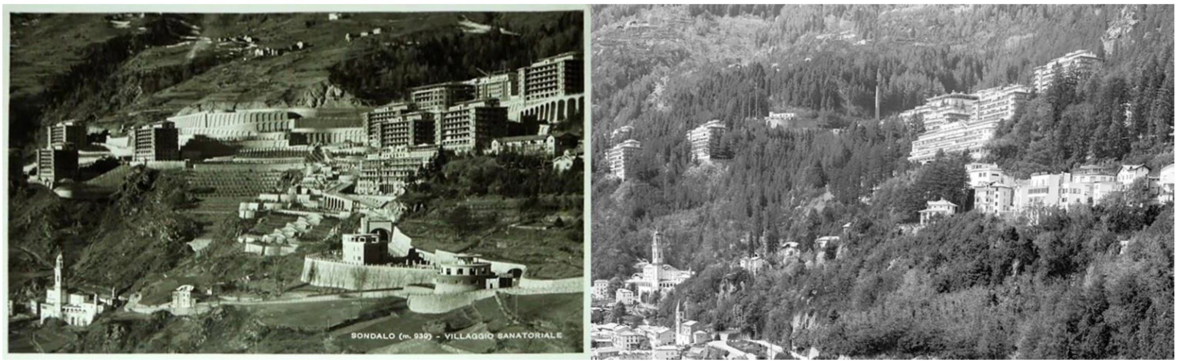
Considering the crashes of trees caused by the climatic events of 2018 and 2019 and the current state of park conservation, the Sondalo Municipality and the ASST-Val highlighted the need to carry out cutting operations to secure the entire wooded area and the gardens. The number and position of the plants to be cut were indicated by the municipal forest guard and by an agronomist appointed by the ASST-Val. Therefore, it was a question of adapting the protection of an architectural and landscape asset to the safety needs endangered by calamitous events, planning new cuts and tree planting in order to restore the image and value of the complex. Consequently, it was necessary to investigate the robustness and state of conservation of the park and the structures present therein, so as to enable the ASST-Val to cope with future requirements. To this end, we evaluated the current situation of the original system, identified the critical elements present, and proposed guidelines for the management and maintenance of the peculiar elements of the park thanks to a single consultation and data management tool.
It was decided to organise a common work plan through a GIS management tool to guide and support the Conservation and Management Plan of the park, to include multiple levels of detail, to systematise the numerous topics, to share data, and to compare the analyses performed by different operators. The Geographic Information System is a common platform that aims to manage an area and a plurality of buildings with varying levels of interest and conservation requirements.
This tool can be used, implemented, and updated by various professionals to store information, remind them of the actions carried out on the site, evaluate the results achieved, and plan subsequent investigations. The general intention was to create a simple management system, conceived to provide an organised and accessible data archive and to guarantee further implementation in line with future research and interventions.
All the information collected during the analytical phase and included in the system was organised into thematic levels that have demonstrated their functionality and effectiveness in the design phases. This process followed the extensive experiences in cultural heritage [29,30]. The applied method can also be transferred to other mountain contexts, especially regarding the process’s descriptive and analytical phases, which are easily adaptable to any park or garden with historical and natural characteristics. While the results achieved could be extended to areas similar in terms of morphology and presence of buildings, functions, and botanical characteristics.
The conservation and management of the 20th-century former sanatorium in the Italian Alps must necessarily be described and integrated into a single system so as not to lose the components analysed and to include all the covered topics in the best way possible. The work was done upstream and downstream through on-site inspections in which the necessary information was collected. The platform was set up considering any needed information already acquired in order to obtain a swift structure with adequate graphic bases to be examined for analysis and design operations. The organisation work is described in detail below, following the development and the addition of the processed materials and the activities carried out. The data were shared to compose a single information database queried to develop critical analysis and identify the actions to be taken during the project.

2.1. The Case Study

The park of the former Sanatorium Village of Sondalo, now Eugenio Morelli Hospital, covers about 35 hectares, making it the largest sanatorium park in Europe [42]. The complex was built by INPS starting in 1932. In 1946, it gradually came into operation and remained a sanatorium until the 1970s. In 1973, it was transformed into a hospital. This transition marked the beginning of a phase of downsizing and consequent abandonment of some parts. Today, the Eugenio Morelli Hospital in Sondalo is part of the Valtellina and Alto Lario Territorial Social and Health Authority (ASST-Val).
The Morelli Hospital is an important testament of the sanatorium architecture of the first half of the twentieth century for its size and, above all, for the organisation of the whole complex. This is conceived as a natural health machine to guarantee maximum effectiveness from a medical point of view and for the containment of tuberculosis. The complex was built on a mountain slope on which a system of large terraces was set up to house the facilities and the park surrounding them. The choice of the site responded is closely linked to the treatment of tuberculosis, for which a context suitable for heliotherapy treatments and high altitude to facilitate breathing are essential. The complex was built halfway up the mountainside, with massive excavation works on the slopes and the construction of terracing. These housed the pavilions, hospitals, gardens, and other areas created for the safety of the slopes (Figure 2).
On the one hand, the park appears to be a natural garden at the service of the sanatorium complex. On the other, it naturally mitigates the impact of the buildings on the entire valley. A further distinguishing element lies in the curative function of the park itself. In the thirties, antibiotic therapies for the treatment of tuberculosis were not known, and palliative sanatorium treatment was essentially practised based on the isolation of the contagious, rest, over-nutrition, and trust in the benefits of the mountain climate and the exposure to pure air and sun. In addition, it was believed that a coniferous forest was a supportive element for therapies, both for the balsamic essences that enriched the air and for the positive effect of seeing such environment from the terraces. The planting of trees also created a coniferous woodland, essential for the landscape. The forest strongly influences the perception of the complex from the valley, mitigating the visual impact of large buildings. If the presence of the hospital is known to most, less known is the extraordinary nature of the park that surrounds it. In fact, it is not a natural woodland, but a park entirely designed with the aim of “creating a more beautiful, comfortable and healthier environment for its guests” [43] (p.119).
From an environmental point of view, at an altitude of about 1100 m above sea level, the sanatorium complex is located in a transition area between deciduous and coniferous forests. Large scale reforestation and planting of resinous trees performed in the Sondalo area between the late nineteenth and early twentieth centuries were aimed at supporting the construction of the sanatorium. From the map of forest types published by the Regione Lombardia [44], it is possible to analyse the context of the forest formations around the former Sanatorium Village, identifying the main shapes on the slope (Figure 3):
  • conifer woods characteristic of the higher altitudes, i.e., mountain spruce (in green), with the presence of larch (in yellow);
  • deciduous woods, i.e., a mix of maple-lime and maple-ash groves (in blue);
  • anthropogenic formations or reforestation with conifers (in pink);
  • formations of pure or mixed locust trees below the complex (in grey).
After about 70 years since the construction of the complex, the function of some areas has been modified, while in other parts of the complex it has been necessary to cut down numerous trees, both due to the age of the plants and for safety reasons. The state of conservation has also worsened following the Vaia windstorm of 2018 and the calamitous events of 2019. These caused extensive crashes in the western area and motivated subsequent emergency knockdowns in the terraces south of the surgical pavilion.
The greater awareness of the cultural value of the complex has led to the opening of the Sanatorium Museum. In addition, thanks to the studies carried out on the sanatorium village, the perception of the park’s value from a historical point of view and, above all, from a landscape point of view has also increased. Unlike architecture, whose materials undergo a slower decay process, the park is made up of trees, a living element with a life cycle.
The in-depth study of the sanatorium’s archives brought to light an important document, the park delivery inventory, which lists the tree specimens present, indicating the quantities and species in the different areas. Thanks to this document, it was possible to discover that the initial endowment of trees was very high, and it can be said that almost all the areas have preserved their original plantings. However, there are some problems: the trees suffer because of the very dense planting layout, while the numerous terraces complicate maintenance works and make the access to some areas with adequate vehicles more difficult.

2.2. The Analysis of Tree Specimens

The management system has been structured from the beginning of the activities to achieve a common and unified cartographic platform on which to anchor the analysis and insights. However, the numerous maps coming from regional and national geoportals (Figure 4) [45,46,47] have highlighted some deformations and measurement uncertainties that made further investigation necessary. This need led to the creation of a new aerial photo using image-based photogrammetric techniques applied to photographic shots acquired by drone. A detailed ortho-image (Figure 5) and a Digital Surface Model (Figure 6) resulted from these operations and made it possible to create a solid graphic support for the census activities.
These were carried out on a sample of about 1900 trees through a filing operation. The designed form refers to the “Rules for the development of urban green spaces” (Law no. 10 of 14/01/2013) [14] and to the “Guidelines for the management of urban green spaces and first indications for sustainable planning” [15]. The green census is the cognitive tool underlying the planning of the green maintenance programme and the planning of interventions in the arboreal heritage. This is drawn up by qualified professionals (agronomists or foresters) and indicates what information is necessary to construct a database for the public green system. As regards the arboreal or shrub specimens, the following information has been summarised:
  • Unique identification of the subject with a numeric code and geolocation.
  • Taxonomic recognition (genus and species with the scientific name and common name).
  • Indication of the characteristics of the planting site.
  • Photographs of the specimen.
  • Biometric features (height, diameter of the stem, diameter of the collar, diameter of the crown, and height of the free trunk).
  • Qualitative characteristics (phytosanitary status, first visual assessment of stability, location, maintenance needs).
  • Need for interventions (maintenance, consolidation, or demolition).
The conservation status of the specimens was analysed following the “Guidelines for the evaluation of the vegetative conditions” [48], the “Protocol for the evaluation of tree stability and estimate of the risk deriving from subsidence” [49] and the indications contained in the “ISA Protocol” on the evaluation of the stability of trees
The evident defects were identified through a first observation to verify the vegetative and phytosanitary state of the plants. This analysis made it possible to determine if any higher-order evaluations were needed. The assessment of the conservation status of the specimens was also integrated with the definition of the elements of risk or alteration. Finally, a part of the sheet is dedicated to the intervention phases on the single specimen. The form is divided into three sections (a. Identification; b. Vegetational characteristics and phytopathological status; c. Elements of risk and interventions) as shown in Figure 7, Figure 8 and Figure 9.
Of the trees surveyed, 73% belong to the Gymnosperms group. Among these, the species Picea abies, Cedrus deodara, Pseudotsuga menziesii, Pinus nigra, Thuja plicata, and Abies alba represent 63% of the total. If the Picea abies (24.47%) were mainly used in the mitigation forest, today, their presence is significantly reduced compared to the initial quantities. The species Cedrus deodara (13.88%), Pseudotsuga menziesii (9.43%) and Abies alba (3.81%) are important in the park areas. The Pinus nigra species (6.78%) is concentrated in the terracing of the playground, where almost all the specimens are found (Figure 10).
It is important to remember how the Cedrus Atlantica ‘glauca’ plays a landmark role within the park and that two other species are associated with this, Abies concolor and Cupressus arizonica, with grey-blue foliage. Other species with a significant role are Calocedrus decurrens, Chamaecyparis lawsoniana, and Thuja plicata. Their bearing and red bark make these specimens one of the most eye-catching elements in the spaces in which they are inserted. Among the Angiosperms group (27%), the most numerous species are those used for road trees. Tilia americana (20%) is the second most present species in the park, while Acer pseudoplatanus characterises only two avenues and Prunus cerasifera ‘Pissardii’ presence is limited to only 18 specimens in the whole park. The other species are present in a punctual way, in some specific areas of the park, or with a minimum number of specimens.
The highest trees (over 35 m) belong to the species Pseudotsuga menziesii. The specimens west of the Surgical Pavilion reach 42 m in height. In Italy, this species can reach over 60 m; the tree so far recognised as the tallest in Italy is a 62 m high Pseudotsuga menziesii located in the Vallombrosa Forest (FI). In Lombardia, very few trees among those included in the list of monumental trees (Law 10/2013) exceed forty metres in height. Among the conifers, there are only the Abies alba of Roncobello (BG), the Picea abies of Valdisotto (SO), the Cedrus libani of Cugliate Fabiasco (VA), and the Sequoiadendron giganteum of Varese. Therefore, even the Pseudotsughe menziesii of Sondalo Park appears worthy of being included in this list, further enhancing the uniqueness of this botanical itinerary (Figure 10).

3. Results

The drafting of the tree census, combined with inspections, and the designed GIS analysis tools, made it possible to assess the size of the park and its landscape role in relation to the town below on a map of landscape values. A monitoring map was the result coming from the analysis of the data on the conservation status of the trees, combined with the recognition of some risk elements. It identifies the areas of the park and the tree specimens to be monitored. Finally, guidelines have been drawn up for each area into which the park has been divided to support the technical office’s action. The subdivision of the park areas (Figure 11) is based on the role assigned to them in the context of the sanatorium project:
  • Road system: the entire complex is crossed by roads consisting of long inclined ramps and hairpin bends that allow access to the pavilions from two different heights. Some road sections are built on viaducts. The roadway is equipped with trees, mainly Tilia americana and Acer pseudoplatanus.
  • Gardens: some terraces were designed as spaces that patients and visitors could use to benefit from the mountain air, particularly those near the pavilions and others of large dimensions.
  • Park areas: they were assigned a perceptive role, and pedestrian use was limited to the paths marked out. The ground can be flat or sloping.
  • Mitigation forest: the area is not intended for use but plays an essential role in the slope arrangement. It encompasses the areas surrounding the complex and the area of terraces of the Rio valley. The mitigation forest also acts as a link between the park arrangement and the surrounding mountain slope.
  • Spontaneous forest: the area has lost the trees originally planted because they fell down and is now being colonized by other species, mainly Robinia pseudoacacia, whose rapid proliferation today makes it difficult to see many portions of the park.

3.1. Landscape Values Map

The map of landscape values (Figure 12) represents the first result of the analysis of the perception of the park from the town and the valley. The park areas have been divided according to the landscape scale or based on the evaluation of the impact of the vegetation considering the size of the buildings and terraces. The connection to the side of the mountain was also taken into consideration, with particular attention to the mitigation effect. The evaluation is based on four intervals defined as follows:
  • High: areas with a fundamental role in the perception of the complex from the valley.
  • Medium: areas with a partially recognisable landscape perception from the outside of the areas themselves.
  • Low: areas with landscape perception limited to users within the areas.
  • Null: areas devoid of plant elements.
The specific values and characterising elements are described in the forms relating to every single area. The purpose of the landscape value map is to raise awareness about the impact that extensive operations on the plant system, such as knockdowns, can have on the perception of the entire complex. The garden of pavilion n. 5 gives an example of the situation before and after the knocking down of a Cedrus atlantica specimen (Figure 13).
The indication of some specimens worthy of protection has been added to the map of landscape values, as specified in the census of tree specimens. A fundamental role in the park’s design is assigned to the Cedrus atlantica in its glaucous leaf variety. This species has a landmark value and guides the visitor inside the park. The specimens are positioned near the buildings and in visible positions, accompanying those who walk along the main network of roads. Some of these specimens have been knocked down recently (2015–2019) for safety reasons, compromising the immediate understanding of the role assigned to this species in the park (Figure 14).

3.2. State of Conservation

The state of conservation was assessed through a level 1 analysis, which can be then investigated by agronomists or forestry doctors to indicate the appropriate operations for the care or safety of the specimens. The evaluation comprises three macro-categories: phytosanitary, mechanical, and maintenance.
Regarding phytosanitary problems, it is important to detect the presence of dead specimens, which should be removed before the plant collapses, damaging the surrounding samples. Similarly, numerous dry branches can be dangerous if theyoverhang areas with transit of people or vehicles. The presence of holes or cavities has been found, for example, in some specimens of lime trees.
Among the mechanical problems, the inclination of the trunk can be considered a physiological reaction of the plant to the position in which it has grown and to its development. In other places, it is the result of the growth towards the light, and in some contexts, this makes the specimen more unstable and susceptible to collapse in the event of adverse conditions, such as intense storms or winds. The growth of the canopy has been influenced by the situation in which the plant has grown as well. For example, a narrow crown is common in the case of close rows, while an apical canopy often characterises trees growing in the woods. The canopy’s and the branches’ unbalanced growth was reported when they showed a strong asymmetry with respect to the shape of the crown in particular situations (tree in a row, single or in a group).
The following main cases were found regarding maintenance problems: the spontaneous proliferation of new plants in the undergrowth, the growth of vines on the tree specimens, and the lack of maintenance of the lime trees. A further element that has changed the shape of the trees is represented by the pollarding of the specimens along or near the internal road.

3.3. Elements of Risk

The importance of the context for each specimen’s health has led to a clarification of the analysis through the identification of elements of risk or alteration. Therefore, the factors that can affect the health of the specimens and jeopardise the maintenance of the landscape qualities of the park have been identified. In this context, we report mainly inconsistencies. The first is related to the species, for example, the insertion of other tree species in a monospecific row, or to the position, i.e., the planting of a specimen in a space not suitable for the size it will reach at maturity. From the morphological point of view, co-dominant trunks or branches have distinctive features. These are elements of the trunk of almost equal dimensions, whose intersection point represents an element of fragility for the tree structure.
Regarding the outline of the plant, the presence of weeds and the uncontrolled birth of specimens scattered by the wind are noted. There are also ground changes in the vicinity of the root system, mainly due to the formation of new parking areas, underground utilities, or simple ground levelling. These actions can affect the root system by changing the nature of the soil, compacting it, or directly damaging the roots. This can be a crucial factor for the health of the tree.

3.4. Monitoring Map

The monitoring map provides a topographic representation of the elements of risk and alteration to assess the level of attention to be dedicated to each specific park area. In fact, the risk or danger factor related to an arboreal specimen depends not only on the health of a tree but also on the consequences of its fall.
The monitoring levels are set out based on the concept of contact factor, as identified by the “Protocol for the evaluation of tree stability and estimation of the risk deriving from structural failure” [49]. The Protocol describes the possibility of damage that the knocking down of a tree can cause using a scale of 1 to 5, taking into consideration the presence of people or property. Factor 1, minimal damage, indicates rarely frequented areas or resources of little value. On the other hand, factor 5 identifies extreme damage in bustling areas or areas subject to high concentrations of people at certain times of the day, with target assets of high economic or historical value. The height of the single tree also influences the contact factor because it leads to the determination of an area of possible fall equal to at least 1.5 times the size of the specimen.
The monitoring map identifies six levels that can be associated with the different areas of the park (Figure 15), according to the following values:
  • Level 1: areas rarely frequented and without assets that can be damaged by the fall of the tree.
  • Level 2: areas only sporadically frequented and with assets of little value that can be damaged by the fall of the tree.
  • Level 3: areas with moderate traffic and the presence of assets that can be damaged.
  • Level 4: road system of the park frequented and with target assets of significant value.
  • Level 5: heavily frequented areas with target assets of high economic value.
  • Level 6: tree specimens that need a specific evaluation due to their state of conservation and the position in which they are placed.

4. Discussion and Conclusions

Thanks to the cognitive-analytical process and based on the data obtained from the census, particularly the state of conservation and the identification of risk elements, it was possible to define some of the actions reported in the guidelines for each area. The goal is to develop a coherent approach to the interventions to be carried out on the entire park, considering the landscape and historical-cultural qualities of the former sanatorium village.
The first factor that emerged is a partial decrease in the variety of tree species compared to the original planting scheme. This is due to the shorter longevity of some species, and the knocking down carried out over time. That reduction has led to the loss of landscape quality in some sections of the park, such as the terraces and the promenade downstream from the surgical pavilion, once characterized by a peculiar arboreal design.
In the tree census forms, an intervention proposal is indicated and divided into three different operational phases:
  • Phase 1 (safety): reduction of the main risks through pruning of dry branches where necessary and knocking down of dead or highly inclined specimens.
  • Phase 2 (project): recovery of the areas subject to previous interventions.
  • Phase 3 (increase in park values): improvement and enhancement of areas of public use, including through the introduction of new plants and the enrichment of the species present.
The actions indicated in the guidelines define the criteria to be followed in the individual areas based on the problems highlighted. These are organised by type, indicating:
  • A—cutting and thinning out actions.
  • B—ordinary maintenance (pruning of the dry branches) and/or extraordinary maintenance.
  • C—new plants.
  • D—actions for the protection of specimens.
The result of the entire process is summarised in the individual guidelines, where the actions are promptly indicated and also take into consideration the implementation aspects, trying to overcome the main obstacles. There is also a complete list of specimens to be monitored with an indication of the related problems. The guidelines have been conceived as a support tool for planning interventions in the Morelli Village Park to provide an adequate summary of the issues to be addressed, as well as to allow the adoption of a unified approach in the absence of a global conservation project.
The first part of the form shows the extracts regarding the area (identifying its perimeter and the type of terrain) and the monitoring map. The second part describes the arboreal census data, with the specimens’ presence, the diameter of the canopy, and a comparison between the species surveyed and those reported in the park delivery report in order to assess the degree of preservation of the original system. The third part identifies the landscape values through an extract from the map, an image of the park elevation with the crowns of the trees in the area, and an extract from the species identification table that allows an evaluation of the actual trees from the point of view of the landscape composition. Finally, in the fourth part, a table identifies the values relating to the state of conservation and risk: for each problem encountered, it is indicated the number of specimens presenting it. There is also a comment on the critical issues regarding the starting project and the current situation. In the fifth part, improvement actions are proposed with reference to the single area and to the specimens affected by the intervention.
For some areas of the park, it was decided to propose some solutions aimed at securing the tree’s safety and recovering some heavily compromised areas. In particular, the solution for the “Piazzale della maternità” (Form no. 5, Figure 16) proposes a reorganisation of the parking space obtained from the dismantling of the garden, in order to recover the landscape features and rearrange the parking areas. The proposed solutions foresee the recovery of the rows of lime trees and conifers as elements for the organisation of the space and the planting of a Cedrus atlantica glauca in place of the two trees that were knocked down. Compared to the original configuration, it was decided to decrease the number of specimens, expand the planting distances among the trees, and use the Tilia tomentosa, which is more adaptable to the park conditions than the Tilia americana.

Author Contributions

Conceptualisation, D.D.C., A.G., G.M. and C.S.; methodology, D.D.C. and A.G.; software, A.G. and C.S.; investigation, A.G. and C.S.; resources, data curation, A.G., G.M. and C.S.; writing—original draft preparation, D.D.C. and A.G.; writing—review and editing, D.D.C., A.G., G.M. and C.S.; visualisation, A.G.; supervision, D.D.C.; project administration, funding acquisition, D.D.C. and G.M. All authors have read and agreed to the published version of the manuscript.

Funding

This research received no external funding.

Data Availability Statement

The data presented in this study are available upon request from the corresponding author.

Conflicts of Interest

The authors declare no conflict of interest.

References

  1. Pirero, S.G. Il “Sanatorio” di Costaraniera e il suo Parco Terapeutico, fra Storia e Attualità, 1st ed.; TSG Edizioni: Taggia, Italy, 2019. [Google Scholar]
  2. Del Curto, D. Il Sanatorio Alpino. Architetture per la Cura Della Tubercolosi dall’Europa alla Valtellina, 1st ed.; Aracne Editrice: Roma, Italy, 2010. [Google Scholar]
  3. Bonesio, L.; Del Curto, D.; Menini, G. Una Questione di Paesaggio. Il Villaggio Morelli e la Valtellina, 1st ed.; Mimesis Edizioni: Udine, Italy, 2014. [Google Scholar]
  4. Del Curto, D.; Menini, G. Il consumo di suolo nella montagna lombarda. Un confronto tra piano e progetto urbano nel Novecento. In Consumo di Suolo, Servizi Ecosistemici e Green Infrastructures: Caratteri Territoriali, Approcci Disciplinari e Progetti Innovativi. Rapporto 2018 CRCS, 1st ed.; Arcidiacono, A., Di Simine, D., Ronchi, S., Salata, S., Eds.; INU Edizioni: Roma, Italy, 2018; pp. 83–91. [Google Scholar]
  5. Fabbri, P. Natura e Cultura del Paesaggio Agrario, 1st ed.; Città Studi Edizioni: Milano, Italy, 1997. [Google Scholar]
  6. Giusti, M.A. Restauro dei Giardini. Teorie e Storia, 1st ed.; Alinea Editrice: Firenze, Italy, 2004; pp. 9–34. [Google Scholar]
  7. Scazzosi, L. Paesaggio Opera Aperta. La Conservazione Delle Architetture Vegetali, 1st ed.; Alinea Editrice: Firenze, Italy, 1993. [Google Scholar]
  8. Cazzani, A.; Zerbi, C.M.; Brumana, R. Management plans and WEB-GIS software applications as active and dynamic tools to conserve and valorise historic public gardens. Int. Arch. Photogramm. Remote Sens. Spatial Inf. Sci. 2019, XLII-2/W15, 291–298. [Google Scholar] [CrossRef] [Green Version]
  9. Boriani, M.; Cazzani, A. Il difficile governo del giardino storico: Molteplicità degli approcci conoscitivi e complessità della gestione dell’intervento. In Giardini Cremonesi, 1st ed.; Brignani, M., Roncai, L., Eds.; Del Miglio Edizioni: Cremona, Italy, 2004; pp. 49–63. [Google Scholar]
  10. Decreto Legislativo n. 42. Codice dei Beni Culturali e del Paesaggio, 22 January 2004. Available online: https://www.beniculturali.it/mibac/multimedia/MiBAC/documents/1226395624032_Codice2004.pdf (accessed on 16 June 2022).
  11. Barbati, C.; Cammelli, M.; Casini, L.; Piperata, G.; Sciullo, G. Diritto del Patrimonio Culturale, 1st ed.; Il Mulino Editore: Bologna, Italy, 2020; pp. 40–53, 143–160, 258–276. [Google Scholar]
  12. Carta dei Giardini Storici di Firenze; ICOMOS: Paris, France, 1982.
  13. Scazzosi, L. Giardini e paesaggi “opera aperta”. I limiti della trasformazione. In Giardini Storici. A 25 Anni Dalla Carta di Firenze: Esperienze e Prospettive, 1st ed.; Pellissetti, L., Scazzosi, L., Eds.; Leo S. Olschki: Firenze, Italy, 2009; pp. 131–157. [Google Scholar]
  14. Legge 10/2013: Norme per lo Sviluppo Degli Spazi Verdi Urbani 2013. Available online: https://www.minambiente.it/sites/default/files/archivio/normativa/legge_14_01_2013_10.pdf (accessed on 2 January 2022).
  15. Strategia Nazionale per il Verde Urbano. Available online: https://www.minambiente.it/sites/default/files/archivio/allegati/comitato%20verde%20pubblico/strategia_verde_urbano.pdf (accessed on 2 January 2022).
  16. Linee Guida per la Gestione del Verde Urbano e Prime Indicazioni per una Pianificazione Sostenibile. Available online: https://www.minambiente.it/sites/default/files/archivio/allegati/comitato%20verde%20pubblico/linee_guida_finale_25_maggio_17.pdf (accessed on 2 January 2022).
  17. Mengoli, S. Fare Verde Urbano, 1st ed.; Edagricole: Milano, Italy, 2013; pp. 103–124. [Google Scholar]
  18. Pettenati, G. I Paesaggi Culturali UNESCO in Italia, 1st ed.; Franco Angeli: Milano, Italy, 2019; pp. 249–255. [Google Scholar]
  19. Kovačević, T. Plitvice Lakes National Park Management Plan, 2019–2028, 1st ed.; Plitvice Lakes National Park Public Institution: Plitvice Lakes, Croatia, 2019; Available online: https://np-plitvicka-jezera.hr/wp-content/uploads/2019/10/Plitvice-Lakes-NP-Management-Plan.pdf (accessed on 16 June 2022).
  20. Harney, M. Gardens and Landscapes in Historic Building Conservation, 1st ed.; John Wiley & Sons: Chichester, UK, 2014. [Google Scholar]
  21. Watkins, J.; Wright, T. The Management and Maintenance of Historic Parks, Gardens and Landscapes, 1st ed.; Frances Lincoln Ltd.: London, UK, 2007. [Google Scholar]
  22. Preparing a Heritage Management Plan, Natural England. Available online: https://assets.publishing.service.gov.uk/government/uploads/system/uploads/attachment_data/file/350304/NE63-preparing-a-heritage-management-plan.pdf (accessed on 10 May 2022).
  23. A Guide to Producing Park and Green Space Management Plans, Cabe Space. Available online: https://webarchive.nationalarchives.gov.uk/20110118142340/http://www.cabe.org.uk/files/parks-and-green-space-management-plans.pdf (accessed on 2 January 2022).
  24. Conservation Principles Policies and Guidance for the Sustainable Management of the Historic Environment, English Heritage. Available online: https://historicengland.org.uk/images-books/publications/conservation-principles-sustainable-management-historic-environment/conservationprinciplespoliciesandguidanceapril08web (accessed on 2 January 2022).
  25. The Burra Charter: The Australia ICOMOS Charter for Places of Cultural Significance, 1st ed.; Australia ICOMOS: Sidney, Australia, 2013.
  26. Croker, A. Respecting the Vision. Sydney Opera House—A Conservation Management Plan, 4th ed.; Sydney Opera House: Sidney, Australia, 2017. [Google Scholar]
  27. Kerr, J.S. Conservation Management Plans. A Guide, 1st ed.; Heritage Lottery Fund: London, UK, 2002. [Google Scholar]
  28. Kerr, J.S. Conservation Plan. A Guide to the Preparation of Conservation Plans for Places of European Cultural Significance, 7th ed.; Australia ICOMOS-International Council on Monuments and Sites: Sidney, Australia, 2013. [Google Scholar]
  29. Petrescu, F. The use of GIS technology in cultural heritage. In Proceedings of the XXI International Symposium CIPA 2007: AntiCIPAting the Future of the Cultural Past, Athens, Greece, 1–6 October 2007; pp. 631–637. Available online: https://www.isprs.org/proceedings/XXXVI/5-C53/papers/FP114.pdf (accessed on 16 June 2022).
  30. Ferreira-Lopes, P. Achieving the state of research pertaining to GIS applications for cultural heritage by a systematic literature review. Int. Arch. Photogramm. Remote Sens. Spatial Inf. Sci. 2018, 42, 169–175. [Google Scholar] [CrossRef] [Green Version]
  31. Aldenderfer, M.; Maschner, H.D.G. (Eds.) Anthropology, Space, and Geographic Information Systems; Oxford University Press: New York, NY, USA, 1996. [Google Scholar]
  32. Goodchild, M.F. The current status of GIS and spatial analysis. J. Geograph. Syst. 2000, 2, 5–10. [Google Scholar] [CrossRef]
  33. Huisman, O.; de By, R.A. (Eds.) Principles of Geographic Information Systems, 4th ed.; The International Institute for Geo-Information Science and Earth Observation (ITC): Enschede, The Netherlands, 2009. [Google Scholar]
  34. Jones, J. GIS project management approach for implementation of GIS for planning organisations. In Research Paper Presented to the Department of Humanities and Social Sciences in Candidacy for the Degree of Master of Science; Northwest Missouri State University: Maryville, MO, USA, 2019. [Google Scholar]
  35. Bender, O.; Boehmer, H.J.; Jens, D.; Schumacher, K.P. Using GIS to analyse long-term cultural landscape change in Southern Germany. Landsc. Urban Plan. 2005, 70, 111–125. [Google Scholar] [CrossRef]
  36. Agapiou, A.; Lysandroua, V.; Alexakis, D.D.; Themistocleous, K.; Cuca, B.; Argyriou, A.; Sarris, A.; Hadjimitsis, D.G. Cultural heritage management and monitoring using remote sensing data and GIS: The case study of Paphos area, Cyprus. Comput. Environ. Urban Syst. 2015, 54, 230–239. [Google Scholar] [CrossRef]
  37. Martín, B.; Ortega, E.; Otero, I.; Arce, R.M. Landscape character assessment with GIS using map-based indicators and photographs in the relationship between landscape and roads. J. Environ. Manag. 2016, 180, 324–334. [Google Scholar] [CrossRef] [PubMed]
  38. Ortiz, R.; Ortiz, P.; Martín, J.M.; Vázquez, M.A. A new approach to the assessment of flooding and dampness hazards in cultural heritage, applied to the historic centre of Seville (Spain). Sci. Total Environ. 2016, 551–552, 546–555. [Google Scholar] [CrossRef] [PubMed]
  39. Elfadaly, A.; Shams Eldein, A.; Lasaponara, R. Cultural Heritage Management Using Remote Sensing Data and GIS Techniques around the Archaeological Area of Ancient Jeddah in Jeddah City, Saudi Arabia. Sustainability 2020, 12, 240. [Google Scholar] [CrossRef] [Green Version]
  40. Campanaro, D.M.; Landeschi, G.; Dell’Unto, N.; Leander Touati, A. 3D GIS for cultural heritage restoration: A ‘white box’ workflow. J. Cult. Herit. 2016, 18, 321–332. [Google Scholar] [CrossRef]
  41. Tobiáš, P. BIM, GIS and semantic models of cultural heritage buildings. Geoinf. FCE CTU 2016, 15, 27–42. [Google Scholar] [CrossRef] [Green Version]
  42. Rossattini, S. Un Villaggio Straordinario. Villaggio Morelli, il più Grande Sanatorio d’Europa. Idea e Ideali fra Medicina, Storia e Natura, 1st ed.; Litostampa Istituto Grafico: Bergamo, Italy, 2002. [Google Scholar]
  43. Cossi, F. Il Parco dell’Ospedale Morelli di Sondalo. In Il villaggio Morelli. Identità Paesaggistica e Patrimonio Monumentale, 1st ed.; Bonesio, L., Del Curto, D., Eds.; Diabasis: Reggio Emilia, Italy, 2011. [Google Scholar]
  44. Carta dei Tipi Forestali, Regione Lombardia. Available online: https://www.regione.lombardia.it/wps/portal/istituzionale/HP/DettaglioPubblicazione/servizi-e-informazioni/enti-e-operatori/agricoltura/boschi-e-foreste/pub-carta-forestale-lombardia-agr/carta-forestale-lombardia (accessed on 2 January 2022).
  45. Geoportale Regione Lombardia. Available online: http://www.geoportale.regione.lombardia.it/ (accessed on 2 January 2022).
  46. Geoportale Comunità Montana Alta Valtellina. Available online: https://maps.cmav.so.it/Geogallery/index.html (accessed on 2 January 2022).
  47. Geoportale Istituto Geografico Militare Italiano. Available online: https://www.igmi.org/ (accessed on 2 January 2022).
  48. Linee Guida per la valutazione Delle Condizioni Vegetative, Fitosanitarie e di Stabilità Degli Alberi. Available online: http://fodaflombardia.conaf.it/sites/fodaflombardia.conaf.it/files/Linee%20guida%20stabilit%C3%A0%20alberi%20Fed%20Agronomi%20Lombardia%20adottato%20febbraio%202016%20def.pdf (accessed on 2 January 2022).
  49. Protocollo per la Valutazione di Stabilità Degli Alberi. Available online: https://docplayer.it/43185269-Ordine-dei-dottori-agronomi-e-dottori-forestali-della-provincia-di-firenze-protocollo-per-la-valutazione-di-stabilita-degli-alberi.html (accessed on 2 January 2022).
Figure 1. The Sanatorium Village of Sondalo seen from the east, a vintage postcard from 1940 and the current situation in 2020.
Sustainability 14 07424 g001
Figure 2. The general plan of the complex: division into areas (in purple the areas referring to gardens and parks, in blue the areas occupied by the road layout, in brown the pavilions).
Sustainability 14 07424 g002
Figure 3. Elaboration of the map of forest types, Lombardy Region [44], area of the former Sanatorium Village of Sondalo.
Sustainability 14 07424 g003
Figure 4. Elaboration of the Ortho-image, Lombardy Region, LiDAR survey, 2015 [45].
Sustainability 14 07424 g004
Figure 5. Detail of the orthophoto generated through drone survey in 2019.
Sustainability 14 07424 g005
Figure 6. Digital Surface Model (DSM), 2019.
Sustainability 14 07424 g006
Figure 7. Section “a” of the form: identification of the tree specimen.
Sustainability 14 07424 g007
Figure 8. Section “b” of the form: vegetation characteristics and phytopathological status of the tree specimen.
Sustainability 14 07424 g008
Figure 9. Section “c” of the form: elements of risk and interventions on the tree specimen.
Sustainability 14 07424 g009
Figure 10. Tree height classes, number of specimens and main species.
Sustainability 14 07424 g010
Figure 11. The general plan of the complex. In evidence, the buildings, and the different areas.
Sustainability 14 07424 g011
Figure 12. Landscape values map.
Sustainability 14 07424 g012
Figure 13. Garden of pavilion n. 5 before (left—photo, April 2019) and after (right—photo, July 2020) the knocking down of the Cedrus atlantica.
Sustainability 14 07424 g013
Figure 14. Cedrus atlantica still present (in green) and knocked down (in red).
Sustainability 14 07424 g014
Figure 15. Monitoring map.
Sustainability 14 07424 g015
Figure 16. Project for the “Piazzale della maternità”, Form n. 5, Solution B.
Sustainability 14 07424 g016
Publisher’s Note: MDPI stays neutral with regard to jurisdictional claims in published maps and institutional affiliations.

