Article

Urban Sustainability and Natural Hazards Management; Designs Using Simulations

by
Paz Fernández
* and
Matías Ceacero-Moreno
Department of Civil Engineering, University of Granada, 18071 Granada, Spain
*
Author to whom correspondence should be addressed.
Sustainability 2021, 13(2), 649; https://doi.org/10.3390/su13020649
Submission received: 12 December 2020 / Revised: 6 January 2021 / Accepted: 8 January 2021 / Published: 12 January 2021

Abstract

:
Sustainability is a topic with deep implications, as reflected by the approval of the 2030 Agenda for the sustainable development that has 17 Sustainable Development Goals (SDGs). One of these SDGs tries to achieve the sustainability of cities, for which we have verified that their resilience is necessary against natural hazards (NH). For the persistence of NH through time on a world scale, it is crucial to train expert technicians in the prevention and control of these risks. For this research, two studies have been made, one focused on research into the training of environmentalists by means of gamification, and the other to verify the potential of this same tool in the NH analysis and management. With this work we have been able to verify that the model of city designed can be an alternative and more sustainable model to the current solutions, also corroborating the usefulness of simulation in their design and its role in the resilience against NH. On the other hand, in relation to the teaching of the subject under study, based on the competences studied, this study is considered successful, demonstrating the utility of gamification and simulations in the formation of environmentalists.

1. Introduction

1.1. Motivation and Concept of the Study

Sustainability is a topic with profound implications, as reflected by the approval of the 2030 Agenda for the sustainable development established by the United Nations (UN) in 2015. This agenda has 17 sustainable-development goals (SDGs) that were signed by all the members of the General Assembly with the overall aim of changing the world [1]. The report Our Common Future, also known as the Brundland Report, presented by the World Commission on Environment and Development (WCED) of the UN defined sustainable development as that which “meets the needs of the present without compromising the ability of future generations to meet their own needs” [2] (pp. 87–88).
Natural hazards (NH) constitute a conceptual element of far-reaching implications for their persistence through time on a world scale and for being involved in the concept of sustainability, both in environmental as well as social terms. Therefore, it is crucial for the present-day as well as future society to train expert technicians in the prevention and control of NH.
The SDGs established by the UN as part of their sustainable-development agenda for the decade 2020–30 include quality education as one of the fundamental goals. We have worked with this goal contextualized in the training of social agents capable of designing sustainable cities and planning for as well as managing NH within the sphere of higher education in the Undergraduate Degree of Environmental Sciences offered at the University of Granada (Spain).
In further studies [3], the researchers found that in Spanish universities, where good teaching practices were developed with Information and Communications Technology (ICT), most of the these practices refer one of the SDGs, quality education (4° ODS), and highlight it as the most novel “in line with educational improvement, the SDGs are beginning to be linked to different educational areas” [3] (p. 2), as we are doing with the present research in the environmental field. In turn, technology connects with sustainability in being international and makes it possible for messages and goals to reach any place, overcoming geographical barriers and thereby exerting an impact on the quality and sustainability of university education worldwide. For this reason, we have investigated the potential of certain technological elements which, through gamification [4,5,6], we have applied to an experience in relation to the higher training of environmental agents.
Therefore, in our research, we are interrelating three topics of great timeliness and relevance for social sustainability: higher education through an active methodology with gamification, urban sustainability, and the impact of the NH in cities, all presented through a process of scientific simulations.
This case study is part of a research project that can be placed within the Design [7,8], having the following as connected focal points: the analysis of the effectiveness of the change in use of a technological-recreational resource through its application to scientific simulations, as well as university training through gamification and guided research. Here we present the first cycle of this research, in which we undertake a case study of the construction of sustainable cities, with simulations produced by the game Cities: Skylines, which becomes an object of study in order to test its validity as a modelling instrument.
We represent the scope of this Research Project in Figure 1. In this paper, only Study 1 is considered. Its aim is to design a sustainable city and manage natural risks in it, using simulations. The method employed involves simulations made through a game that we turn into a serious game. The results indicate that the aforementioned Cities: Skylines game is valid for carrying out simulations in which the characteristics of a sustainable city can be studied as well as the impact that the NH managed exert on the city. Study 2 will be the subject of another publication.
Here, we present part of a university teaching experiment in which we used gamification as a didactic methodology, situating the student in a research setting (the student assumes the role of the researcher and carries out actions as such), while the investigative resource employed was a simulation game, used with the objective of designing sustainable cities. It bears emphasizing that the simulation games had a strong educational effect, increasing certain skills of the player, as demonstrated in earlier research [9].

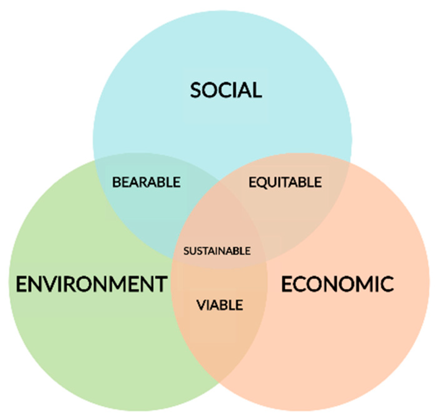
1.2. Importance of Natural Hazards in the Sustainable Cities

For the recurrent use of the term “natural hazards” (NH) throughout this work, we offer certain definitions. To explain what a NH is, we need first to define the process. We consider processes to be physical, chemical, and biological phenomena that affect the surface of the earth, such as volcanic eruptions, earthquakes, landslides, and floods [10]. Internal processes, in which forces inside the earth act (mostly related to plate tectonics) can be distinguished from forces on the exterior or near it (often related to meteorology) [11]. Hence, we can define a NH as any natural process that threatens human life or property, although the process is not a hazard in itself but only becomes one when threatening human interests [11]. Furthermore, all the risk factors must be present for the damage to occur [12], these being [13]:
  • Hazard (H): referring to the probability of a potentially damaging phenomenon within a specific time frame and a given physical area.
  • Vulnerability (V): expressed on a scale of 0 (no loss) to 1 (total loss) represents “the degree of losses suffered by a given element or group of elements at risk, as the consequence of a natural phenomenon of a certain magnitude.”
  • Elements at risk (E): “These constitute the population, properties, activities, public economics, services, infrastructures, goods of any type that are subjected to a hazard in a given region.”
Taking into account all of these elements, natural hazard or natural risk (R) parameter can be defined as [13]: the “expected number of victims, injuries, property damages or perturbation of economic activity as a consequence of a given natural phenomenon.”
R = H · V · E
The effect of these hazards on a society over a given time period and in a certain geographical region is known as a natural disaster. This term is normally used when the effects of a natural process causes major damage in terms of property, injuries, and loss of life [11]. On the other hand, if this damage requires a major investment of time and money for recovery, it is known as a catastrophe [11]. According to other researchers [14], the measures used to combat these effects can be classified as follows: preventive, if designed to avoid or reduce the damage caused by hazards; palliative, if implemented during the process; or reconstructive, if directed to repair the damages and offset losses. In turn, these measures can be grouped as sectorial when applied to only one hazard, or general when used for total coverage [14]. These can be classified also as structural or engineering measures when they require the construction of some type of civil infrastructure, or non-structural or managerial when they involve action such as land management [12].
In relation to the measures to fight against NH, we seek to evaluate the respective spatial perception of the different risks at the regional level [15], to optimize preventive measures.
Land management has proved to be the most effective, rational, and sustainable tool for reducing both vulnerability as well as exposure to these processes [14]. Nevertheless, this may present certain drawbacks, as these plans are intended to promote development [16], which can encourage human activities that are incompatible with the environment where they occur [14]. Therefore, alternative measures are available such as Civil Protection, a public service intended to forecast (analyze hazard), prevent (study and implement measures), plan (establish lines of action), intervene (protect human lives and property after an event), and rehabilitate (establish services to return the situation to normal) [16]. Although at times conflict has arisen regarding which facet would provide the greatest effectiveness, these measures are not considered to be in conflict but rather compatible with each other [16].
With respect to the study of city planning and NH management, tools have recently emerged for city planning that incorporate technologies such as GIS based on 3D models and computer-assisted design [17], as well as more specific programs such as CityJSON [18].
In relation to the sustainability of these population centers, the eleventh SDGs of the UN specifies that the fundamental manner to achieve this is the reduction of the damages from natural disasters. According to the World Health Organization, these NH cause 90,000 deaths and affect some 160 million people per year worldwide [19]. Added to these effects on people, are socioeconomic repercussions such as the direct loss of property (infrastructures, buildings, agricultural land, etc.,), indirect losses in production of goods and services (interruptions of business and public services such as transport, health, and education), and intangible losses, such as environmental harm [19]. In this regard, the authors [20] agree with our work that: Analysis at the district level can help define priorities in different areas in order to design appropriate prevention measures and improve the effectiveness of prevention and the allocation of fire resources. Since specifically in this risk: “this seems to be an appropriate approach in districts where deliberate and negligent ignitions predominate” [20] (p. 12).
In this light, it becomes evident that actions are needed to avoid, minimize, and repair these effects caused by NH, such as the techno-computer tools mentioned above.

1.3. Research Objectives

1.3.1. General Goal

This study has a dual goal: to delve into the design and management of cities as well as into their sustainability; and to determine the effects of the different NH in the city, using simulations.

1.3.2. Specific Objectives

The following were the specific objectives:
  • To ascertain and characterize the relation between sustainability and NH, checking if sustainability really contributes to NH impact reduction in urban environments.
  • To design a functional, sustainable city, with computer game called Cities: Skylines that considered several aspects in the designing process as energy production, education, health system, waste management, and risk reduction measurements among others.
  • To check the effects of different NH in the city, as well as the effectiveness of the different measures to control them, using simulation processes and depending on the severity of each NH.
  • To test the potential of simulations for the analysis and management of NH: once we simulate the different NH with different severities, we check how the simulation process can contribute to them.
To achieve these objectives, a research method and materials and tools were planned. These, together with the background framework, have enabled us to carry out the experimental case study called “case Study 1.”

2. Background and Framework

2.1. Simulations and “Serious Games”

In general, a game, and also video games, can be defined as systems involving one or more of the players in an abstract challenge defined by the rules, interactivity, and feedback that lead to a measurable result [21]. Role-playing games are popular and in these cases the player assumes a role different from the person’s daily life, such as a researcher (in the present case) and this shapes the activities that this person undertakes during the game. Other games are called “exploration,” in which the players interact to find objects. The idea in these games is that the player should explore the environment to decide what to do afterwards, how to proceed, and how to win. In these games, such as SimCity, a set of variables must be balanced while trying to make the city grow. The balance is the key to success over the entire game as in Minecraft, the most popular of this type. In our case, we practice a role-playing game that leads to another game in which the player must explore the environment and does so by means of simulations, all within a setting of gamification or the use of the rules of the games but with a higher-educational goal.
Simulations can be considered part of the group known as “serious games,” since they are games but are used with an additional aim apart from entertainment [22]. Serious games, without losing their enjoyment quality, also serve other ends beyond the game itself. Normally, these imply video games and were created with the definite aim of serving a second function, in addition to the purely entertainment one. Thus, “a simulation game combines the characteristics of a game (e.g., skill, cooperation, rules, participants, role) with those of a simulation (i.e., incorporation of characteristics critical to reality). A game is a simulation game when its rules refer to an empirical model of reality” [9] (p. 3).
The games are designed for a main purpose other than pure fun, although they use entertainment to achieve their goal. Normally, the adjective “serious” refers to their use in business or industrial settings. There is a relation with all the subject matters, such as: The invasion of the mutants, a game where school children learn traffic rules (Spain); President Election Game 2016, where the entire USA election process is taught; Stop Disasters Game, where the player must keep different natural disasters from causing damage, a game closely in line with our aim but not used by us for having a narrower range of objectives [23].
A consensus appears to exist in the academic community on the use of simulators and games in general to develop and achieve skills. At present, almost 3000 games can be found in the data base of Serious Games [9]
A simulator is a set of elements that seek to recreate a real-life situation. Normally, computer means are used for this recreation, in addition to others such as mechanical ones, to attain the highest degree of realism possible. In general, the element “fun” is disregarded beyond the mere fact of using the simulator itself, and thus they diverge from serious games, although some authors closely relate them [24].
A simulation is a representation of reality, which can be an abstract model of a process, whether simplified or accelerated. It is meant to perform like the original system [25]. On the other hand, “[…] a simulation game combines the characteristics of a game (competition, cooperation, rules, participants, role, etc.) with those of a simulation (incorporation of critical characteristics of reality). A game is a simulation if its rules refer to an empirical model of reality” [9] (p. 87). The use of simulations from a real business setting enables the participants to develop their abilities through learning by experience while taking on the decision-making process and real problems faced by directors, all of this within an atmosphere where the risk of real errors is not assumed [26].
The study by Carson (1969, p. 39) establishing that “business simulators are case studies with the addition of feedback and the dimension of time” (cited in 9) proved germane to our purposes for its similarity with our approach, in which we make a case study, examining the training effectiveness of the process undertaken. This agrees with [25], who stated that a business game is a serious game within an entrepreneurial context that can give rise to one or both of the following results: the training of players in business skills and/or the evaluation of the actions of the players. Analogously, Ref. [26] showed that participants in business simulations are positively scored in most general and specific competition during the participation in games. In this sense, Ref. [24] observed from a general view that students in virtual environments positively value the skills acquired during the simulation. Simulators furthermore present a number of positive points related to the skills achieved and developed by the participants in simulation, since apart from skills related to the use of technology, they reinforce all personal abilities, such as the capacity to manage time, the delegation of tasks, or the integration of ethics in decision-making [9] (p. 1).
The paper by [21] concerning a classification of video games, based on the methodology that proposed to classify Russian fairytales, enables the classification of all video games according to their rules, with serious games being one type. Meanwhile, Ref. [27], in a systematic review of 76 publications on educational technology published between 2006 and 2016, found that the research methodology used was qualitative and within this the case study was the most commonly used because “it adapts to each reality and takes on specific modalities according to hits context and aim” [27] (p. 130). This coincides with the methodology of our study. This author found only one work on serious games and their evaluation [28].
The evaluation of serious games requires attention since “although there is a growing body of evidence on the effectiveness of games for learning, the evaluation is often poorly designed, incomplete, or biased, if not completely absent” [28] (p. 4334). Steiner developed a model of evaluation of serious games developed in the European project RAGE, which introduced multiple perspectives such as learning, the producing and developing of games, for an evaluation of serious games. In the learning, the author establishes several levels of evaluation. The first is the scoring of player satisfaction (manifested by two variables, i.e., usability and entertainment level). Level two is related to the objectives of learning and the results pursued in the training context. At this level, the evaluation reflects whether the students acquire the specific knowledge and abilities on interacting with the serious game and to what degree. Level three concerns the question of whether the students are capable of applying the knowledge and the skills developed during the game in the real world (transference). At the fourth level, the evaluation deals with the institutional perspective in terms of pedagogical value and the benefit of the serious games for the providers of training or educational institutions. The author concludes that this model for the evaluation encourages research to make more rigorous evaluation.
If we apply this model to the game used in our study, we see that it exceeded level one, since the student was satisfied with the usability of the game and the result was fun. Also, it reached level two, since the student attained a high level of knowledge and specific abilities by interacting with the game. The transference could not be evaluated, since, as the author states, it is evaluated over the middle and long term. Also, the institutional interest was high, since the university has accepted the proposal of the professor and has bought the game and its extensions. Thus, in this scenario, the game chosen was positively evaluated at all three levels.
Other authors in their research have also found full acceptance of these games to make simulations [9,22,29,30,31,32]. The simulations require students “to build their own knowledge, to pose their own questions, to generate and explore their own models, and to construct the representations that organize their experiences, instead of derive them from the words of the professor. For all this, this methodology intensifies the motivation to learn” [31] (pp. 12–14). Students perceive serious games as useful tools to develop skills, both general as well as specific ones related to the subject matter, especially for decision making and problem solving in fun learning experiences [31].
The site http://serious.gameclassification.com/ [33] is a collaborative classification system suited to Serious Games, based on multiple criteria. The games are classified according to their gameplay, their purposes, their markets and target audience, together with user-contributed keywords. In this platform with multiple classification criteria, we used the criteria Education, Training, Ecology, and Student, 17–25 years, selecting five serious games which we analyze and compare with our Cities: Skylines (Table 1).
Education is key for reducing children’s risks to disasters. Although children are one of the most vulnerable groups when disasters occur, if they are taught from an early age about the risks posed by natural hazards, they will have a better chance to save their lives during disasters. This online game aims at teaching children how to build safer villages and cities against disasters. Through playing, children will learn how the location and the construction materials of houses can make a difference when disasters strike and how early warning systems, evacuation plans, and education can save lives. Given that children are the future architects, mayors, doctors, and parents, if they know how to reduce the impact of disasters, they will create a safer world.
Cities: Skylines had the intentions when it was created to promote fun and playing, and to be informative, and we have added in our simulation the objectives of education in ecology and training of professionals in environmental management. Also, we required that each simulation be done with data that makes sense in the real world, according to the literature consulted and not with any random data. In this way, we have turned it into a serious game. Therefore, this game has ecology and education in common with all other selected serious games, and has more similarity in its rules and forms of play with The Green Hipster Hotel and CityOne: A Smarter Planet game. It has in common with Stop Disasters Game the subject of natural hazards, but this is simpler in its objectives and norms, being advisable to introduce the subject to children. In conclusion, the game used has similarities with all the others selected in terms of ecology and education and differs in the objective of training environmental professionals, a condition that we have imposed in order for this approach to become a serious game to perform sustainable city-design simulations.
A second website also proved useful, including numerous serious games [34], an analysis of them is beyond the scope of the present study and will thus be addressed in a future work.

2.2. Simulators

The simulators are computer programs that model a real setting (e.g., a real situation such as the functioning of a business, a financial enterprise, traffic in a city) and allow actions on a model, presenting reactions similar to those that occur in the real world. The simulation activities have been used for years in social sectors in which it is not possible to make experiments to the satisfaction of the researcher (e.g., in medicine, economy or environment) or doing so would imply enormous costs or undesired consequences (e.g., in energy, communications, transport) [25]. Many studies have focused on simulators, for example in the field of computers [35], which examine the functioning of the vehicular networks by simulation and make an extensive review of the tools available for the simulation of vehicular networks. An analysis has been made of the traffic simulator STRAW (Street RAndom Waypoint), capable of simulating real activity of vehicles with a high degree of detail [35] (p. 51). Also, it analyses other simulators to transmit multimedia elements in settings of communication between vehicles, “checking the viability of the use of simulation tools for the deployment of vehicular networks in the city…varying the number of vehicles in circulation” [35] (p. 62). Training simulators emerged in the military and aviation and are expanding into all other fields of training [36,37] and their formative effectiveness has been demonstrated.
The simulator equips the student for practical thinking, rather than theoretical. This is generated with the aim of achieving something specific, associated with particular phenomena, focused on the meaning of specific actions and depending on what is feasible. It improves professional training quality, optimizing capacity building, preparing the student to put theoretic knowledge into practice as well as understanding the functioning of a system, generating analytical skill, evaluating different scenarios, developing methods of analysis, and reducing the probability of error in decision-making [36] (p. 1). For [38], the objective is to provide a methodology of using computational tools of simulation in the new training scenarios of the digital era, for its power in teaching mental structures that the student will need to apply theoretic knowledge in reality. According to these authors, “simulators have a high potential to provide secure and controlled scenarios of experimentation with the elements needed for the student to actively commits to the construction of his or her own functional and efficient mental structure” [38] (p. 309).
However, simulators do not transmit the fun aspect of games, the only satisfaction being that of being able to operate the simulator to solve problems that might emerge in real life. Many authors have studied simulators [37,39], but in our work we have used a serious game instead of a simulator. We examine simulators only to indicate the similarities and differences between the two technological resources [36,37] and their formative effectiveness has been demonstrated.

2.3. Simulation to Design Sustainable Cities

Many simulations are used in business and in different areas of engineering, and simulations have been made in the field of energy. Previous authors [40] have undertaken an automatic computational process for morphological generation and simulation in order to evaluate the solar-energy consumption and the access of solar radiation. Other authors [41] have used the simulation to estimate the energy curve for buildings. However, we have found few studies similar to ours, apart from one notable work [42] which shows the creation of digital urban twins for the sphere of city planning, in which urban mobility and wind flow are simulated. Also, virtual reality has been used [43] to generate digital twins for civic participation in urban planning. These models enable simulations to predict the behavior in the real world. The digital twins (digital representatives of material and immaterial objects from the real world) offer a great potential in the field of digital tools to deal with the complexity of cities, with the possibility of also involving citizens in the participation process. These representations may contain models, simulations, or algorithms that can describe their characteristics and behavior in the real world.
Recently, digital twins were implemented in planning processes. For the generation of the digital twin, these authors used a variety of techniques and methods, such as 3D models, spatial syntaxis, mobility simulation, wind simulation, movement patterns of people, data of stationary activity, and qualitative data. This representation provided the opportunity to test a number of scenarios and their possible solutions, checking their impact by using a real-life case. However, these authors concluded that because it was a model and thus an abstraction of reality (not being exact copies), the digital models did not include all the information from real life. Finally, these authors did not conclude that this tool can improve decision-making for the creation of intelligent and sustainable cities. Another work with similarities to ours [43] made simulations of the changes in soil use in order to determine how this affects the resilience and sustainability of cities, as stated in the 11 SDGs. Half of humanity lives in cities and by 2030 some 60% will live in urban areas. The rapid urbanization is exerting pressure on natural resources, the environment, and public health.
To end poverty, protect the planet, and ensure prosperity, the United Nations established 17 SDGs, notably 11, with the aim of making cities inclusive, safe, resistant, and sustainable. Both land use as well as its cover can directly influence society and ecology. Human activities have been the main motor of land-use change in recent years, especially urbanization. This research has predicted the dynamics of land-use changes based on different scenarios. Furthermore, the authors state that this study will be beneficial for researchers, urban planners, and city-design policies. We have found almost no studies that apply simulations to design sustainable cities, and fewer that still use simulations to test the effect of the NH in these cities and the management of these effects in order to minimize them.
Thus, our work is unique in that it uses gamification as a didactic system, by which a student, in the role of a researcher, generates an adaptation of a game in order to design simulations of a sustainable city. Here, we provide only the results of the simulation of the sustainable city and of the effects of one of the risks in the urban area, while the rest of the results will constitute a future publication. Therefore, the aim of this paper is to show the results of the simulations made in order to study the characteristics of a sustainable city and the management of the NH in it, using an example.

2.4. Sustainable Cities Design

Current urban centers clearly follow an unsustainable model to a greater or lesser extent. Therefore, numerous authors have studied the impact of these centers on the environment, examining new models that mitigate the damage as much as possible. Saaty and De Paola, in their article entitled “Rethinking Design and Urban Planning for Cities of the Future,” published in 2017 by Buildings [44], sought to determine the best model for cities of the future. After analyzing the advantages and disadvantages of several types, these authors concluded that, regarding urban planning and design, a compact circular city is the optimal model, taking into account factors such as urban expansion, the transformation of the buildings, and environmental impact. Furthermore, the strength of this model is the equidistance between various points as well as the optimal distribution for public transport [45]. On the other hand, for greater sustainability, their design layered different zonings, designating the central space as residential (with gardens on roofs and walls) and the outermost as industrial zones, thereby reducing the pollution within the city [45]. This model could direct the current path toward sustainability, transforming cities into sustainable systems, which could be defined as any human urban center (city, metropolis, megalopolis, etc.,) interacting with or in equilibrium with sustainable development [44]. In this sense, the Brundtland Report, on defining sustainable development (as mentioned above) as meeting the needs of the present without compromising the ability of future generations to meet their own needs [2], establishes a three-dimensional concept that encompasses economic, social, and environmental issues, which are interrelated [46]. We call these the three pillars of sustainable development (Figure 2).
In accord with the bases of sustainable development, a city, in social terms, should advance toward the general wellbeing and improved quality of living for the population by fomenting employment opportunities, reducing poverty, and improving education and health services [44]. On the other hand, as stated by the author, in economic terms, the city should develop according to the model of economic growth, adjusting to the load capacity of the ecosystem. Finally, regarding the environment, progress toward conservation, pollution reduction, the use of sustainable resources, and rational land use should be promoted. In this sense, ecological urban planning should prioritize the use of public transport as well as bicycle and pedestrian circulation over the use of private motorized vehicles. Also, natural areas should be incorporated into city planning together with mixed land uses, renewable energy, sustainable water use, and the reuse/recycling of wastes [44].
Although sustainable development requires compliance with all 17 of the SDGs of the UN, we shall focus here on the eleventh for its close relation to the present work. This eleventh SDGs seeks to make urban centers more inclusive, safer, more resilient, and more sustainable, setting the following goals for 2030:
  • Ensure that all people have access to adequate dwellings and services in a safe and affordable way while improving marginalized neighborhoods.
  • Provide access to safe, affordable, accessible, and sustainable transport systems for the entire population and improve traffic safety, in particular by expanding public transport, paying special attention to the needs of the vulnerable, i.e., women, children, the aged, and the disabled.
  • Increase inclusive and sustainable urban planning as well as the capacity for participative, integrated, and sustainable planning and management of population centers in all countries.
  • Strengthen efforts to protect cultural and natural heritage of the world.
  • Significantly reduce the number of deaths caused by disasters, including those related to water, reducing the number of people affected while diminishing the economic losses directly sustained in comparison to the world gross domestic product, placing special emphasis on protecting the poor and underprivileged.
  • Diminish the negative environmental impact per capita of cities, especially emphasizing air quality and waste management.
  • Provide universal access to green areas as well as safe, inclusive, and accessible public areas, particularly for women, children, the elderly, and the disabled [47].
Similarly, for 2020, this goal included an improvement of economic, social, and environmental ties between urban, suburban, and rural areas, in addition to more efficient use of resources, the mitigation of climatic change, and the resilience against natural disasters, while offering support to less advanced countries [1].
However, although the countries closest to complying with the SDGs are European, none of them has achieved the goals established for the eleventh SDGs [48]. It bears mentioning that to fulfil the goals of this SDG and thereby reach sustainability, cities also need to reach other goals, as these are interrelated [47]. In this sense, the eleventh SDG can be considered central with respect to other SDGs (Figure 3).
As shown in the figure, for cities to be sustainable, one of the key points is public mobility, this being one of the goals of this SDG. Some authors [49] indicate how to satisfy the needs of the society to move freely, permitting access, communication, commerce, and getting together without sacrificing other essential ecological or human values in the present or in the future. These characteristics notably include the provision of three lanes in which the center is used exclusively by buses in addition to a bus line that connects health centers [49] (p. 68). Re-examining the eleventh SDG, we see that one of the ends is to make cities resilient and resistant to NH. Walker (2005) defined ecological resilience as “the capacity of a system to absorb impacts and reorganize itself while undergoing change, but in such a way as to maintain essentially the same function, structure, identity, and feedback systems” [2] (p. 137).
Other authors [50] have adapted this definition to urban resilience, defined as the capacity of a city and its urban systems (social, economic, natural, human, technological, and physical) to absorb damage and reduce the impact of a perturbation as well as to adapt to those changes. In this sense, urban resilience is based on four concepts: resistance, recovery, adaptation, and transformation. These in turn can be divided into five dimensions: natural, economic, fiscal, social, and institutional. Finally, these authors conclude that tools, methods, and means are lacking to evaluate the resilience of cities, this being a challenge for the future.
Therefore, the reduction of damage caused by SDGs is fundamental in attaining sustainability in cities, while public safety and social cohesion are priorities for this [51]. For the mitigation of these effects, preparation and training are fundamental, the prime objective being the reduction of hazards, once the potential risk factors are identified [51]. This preparation is based on the analysis and management of the hazards, implemented in three phases: (1) inventory of risk factors; (2) management of risk factors; and (3) the evaluation of the hazard and the analysis to reduce risk, which can be completed in several phases [12].

3. Materials and Methods

3.1. Methodology and Study Materials

For the overall research, we used the methodology known as Design-Based Research [7,8], “the main characteristics of which are: (i) the decision of placing the research into the natural context; (ii) the purpose of causing specific changes in this context; (iii) the option for the systemic focal points; and (iv) the cyclic and repetitive character of the designs” [52] (p. 2). Also, it “seeks to understand and improve the educational experience through the consideration of natural contexts in all their complexity, and of the development and analysis parallel to a specific instructional design” [53] (p. 75).
To carry out the work of “case Study 1” an experimental study has been prepared that includes several simulations and the “conceptual analysis” of all the product generated in the simulations, in light of the background framework also prepared by means of bibliographic search, as part of the job. Thus, it has been possible to design a sustainable city model, in addition to being able to carry out simulations of a series of natural hazards, which have been recorded and subsequently analyzed.
The recording materials have made possible to assess the simulation tool, as well as to formulate a model of the facts that are the object of scientific interest. This in turn enabled us to establish a didactic system for studying (the tool or game that we have adapted and the simulations developed with this game). This obviated the physical simulation of natural disasters, which would be either impossible or undesirable.
In addition, for this work, in the construction stage of the city and in the simulation of the NH, we have used gamification. This technique consists of the application of gaming resources (designs, dynamics, elements, etc.,) in non-gaming contexts in order to alter the behavior of individuals [4]. Other authors [53] have stated that gamification can have several applications, being highly developed in the business world (with the aim of guiding the behavior of customers and employees). In its use in governmental contexts, it can serve to improve citizen participation, as might be the case with the project Speed Camera Lottery, based on the contest for ideas to address social needs [4].

3.2. The Tool in This Study

With respect to the video game used as a resource in gamification of this work, Cities: Skylines, several authors have written about its possibilities in diverse uses, such as simulation and visualization of real cities [54]. It has already been used for spatial planning purposes by [55], who analyzed its potential to be used as an educational method in land-use management and made an evaluation of it, concluding that this game has advantages and inconveniences compared to others, as a territorial planning tool.
Accepting this evaluation, we chose the game as a simulation tool for this research on NH in a city, since it permits the building of approximate models which, although simplified, represent reality. Its weaknesses and threats are clearly perceptible and thus can be taken into account in a teaching-learning process for this subject matter at the university level.
We have found no references to this way of using this game, and therefore we consider our research to be novel regarding its use in the NH analysis and management, as we shown in Figure 4.
The main material used in Study 1 was, as indicated above, Cities: Skylines, (https://www.citiesskylines.com/) [56], a video game based on the construction of cities, in which we acted as the mayor of the city that we created, which we had to design from the beginning with urban planning. We had to establish the network of highways, the energy sources, and the water-storage and -purification systems, etc. Similarly, we had to manage services such as education, health, and safety of our population. Under the role of mayor, we also had to manage the finances and legal systems in our city. We started with the hypothesis that the material used, Cities: Skylines, had the potential both as an urban-planning tool, as in the Analysis of the Management of Natural Hazards.
To test this hypothesis, we used a set of variables such as the sustainable city itself to be constructed and the measures to prevent and minimize the impact of natural damage. In this sense, so that our city could attain sustainability, these measures needed to be effective in comparison with another city without them, where we assumed that the losses would be greater after the same catastrophe. We tested this assumption by running several simulations.
The game is structured on several levels depending on the number of citizens, as this is based on the development of our city until reaching the maximum population possible. We began with a village of 500 inhabitants and expanded our population to a town of 16,000 and then to a megapolis that according to the game starts at 75,000, finally establishing the size of our city at 147,000 inhabitants.
By surpassing each of these levels, we achieved certain rewards that increased the functionality of the game, such as more terrain for our city or expanded services (e.g., new public transport), new energy sources, or new laws. To attain a larger population and surpass a level, we had to establish, according to demand, larger residential zones, commercial zones, and industrial zones, establishing services that included water, electricity, garbage, and security, among others.
The game had a panel of information in different sections concerning the characteristics of the city. The sections were: utilities, garbage, and education (the game indicates the availability of schools, universities, and libraries as well as their capacity and use by the population), happiness, health, traffic, wind, pollution (soil and water contamination in our city), noise pollution, fire services (coverage and risk in the area), crime (police services and crime rate in our city), transport (traffic fluidity in our city), population (and employment data in our city), land value (in each sector of our city), natural resources, districts (the game delineates the different districts in our city), leisure, land elevation (represented by contour lines), escape routes (the game indicates evacuation routes in the event of a hazard), radio coverage (the game displays the strength of the signal of certain methods of catastrophe detection), destruction (the game indicates the degree of destruction undergone in the territory from a certain process), catastrophe detection (the game gives information on coverage for earthquake detection, for example), traffic routes (the game shows the path to follow by pedestrians, bicycles, autos, and other forms of transport), tourism (the game indicates the tourist attractions in our city as well as the number of tourists), guided visits (the game specifies the number of tourists and residents that use tourist transport systems), and park maintenance (the game reports on the conditions of the different parks Furthermore, to enhance the potential of the game, several extensions of the game were added.
First, the video game Cities: Skylines—Green Cities was acquired to help make our city more environmentally sustainable. This game gave us the ability, among other things, to control acoustic and environmental pollution, to establish ecological shops or to establish vertical gardens on our buildings. In addition, we acquired Cities: Skylines—Natural Disasters, a key resource that provided a great quantity of NH that could be simulated in our city, as well as a number of elements that enabled us to plan prevention measures for these hazards.
Also, we added Cities: Skylines–Parklife, as it enabled the generation of green areas such as parks that would be highly useful in making our city sustainable. Finally, we acquired Cities: Skylines—After Dark. Although the main characteristic of this latter video game is to introduce nightlife into our city, we used it also to add new means of transport that aided the sustainability of the city, such as bicycles and the bus lane.

4. Scheduling of the Study: Phases of the Methodological Design

Study was performed in different phases (following the teacher’s instructions), summarized by the student in Figure 5. These included bibliographic stages (in yellow), others of experimentation/research (in green), and some of the analyses and conclusions (in red). Blue indicates phases preceding and following the research work within the university sphere. Below, these are explained.

4.1. Phase 2: Initial Design of the City

To begin this phase, we selected a modality of gaming, since we could choose between managing a predesigned city or design our own. Opting for the latter, we selected a map on which to begin the construction of our city. With this start, the game forced us to construct a highway that we had to join to the existing dual carriageway by default to the surrounding territory, and we successfully added services until producing a city [9]. Below, Figure 6 presents the design of this city. On the left, appears a hint of the initial square design of the city, situating the industrial zone to the northeast, toward the outskirts of the city. While consulting the literature, we began to establish a circular city model to the right, since because part of phase 2 and 1 were undertaken simultaneously. We found that the city model designed was not appropriate, as it did not coincide with the information in the literature.

4.2. Phase 4: Finalization of the City Design

To finish designing the city, we began the game and let time pass in order to verify whether the city was functional and whether it had adequate services situated in the appropriate places. After confirming the adequate effectiveness of this city, we made two copies of it. In one of these, we installed preventive measures for NH, while the other lacked these measures. The game offered us several preventive measures. First, we found refuges of different sizes that enabled evacuations of the population, and these refuges were established in each district. We also found emergency units, in charge of sending helicopters and lorries with personnel for rescuing survivors of a catastrophe. Due to the large size, this building was situated on the edge of the city. Also, we situated radio antennas in the city center, acting as emergency relays in case of evacuation. On the other hand, we found sectorial measures for the different NH: in the city center, we established sensors to detect earthquakes, as well as climate radars to identify storms and tornados. Also, on the outskirts of the city, we had deep-space radar to locate meteorites, and watchtowers were situated near forest stands outside the city to warn of forest fires. Below, Figure 7 provides an aerial photo of the city after completion.

4.3. Phase 6: Simulation of NH

The expansion of Cities: Skylines—Natural Disasters enabled us to simulate several NH, these being: tornados, earthquakes, land subsidence, storms, forest fires, tsunamis, and meteorites. The tsunamis, although being NH, were not simulated because our city had no ocean nearby. All these NH are defined by a single magnitude, which the game designated as severity of between 1 (minimum value) to 10 (maximum value). The game included a modality in which these hazards appeared by chance and with a random magnitude. However, we did not use this function, as we wished to simulate each process in a certain place at a definite magnitude.
To simulate the different NH, we followed the same procedure beginning with a simulation at a magnitude of 10 in the city that had preventive measures. In the same place, with the same magnitude, and at the same time, this process was repeated, but this time in the city without preventive measures. In this way, we sought to determine the difference between the losses undergone in the two cities. Afterwards, in the city with preventive measures, we made two further simulations of the same phenomenon, in the same place and time as the previous one, but in this case with different magnitudes. For this, we selected an intermediate magnitude (5.5), which the game offered by default, and the minimum magnitude (1). This was intended to determine the difference in losses at different magnitudes and distinguish how the emergency services acted in different situations. In addition, the different natural risks had been simulated in various areas to confirm the effectiveness of the emergency services. Below, we describe the process followed for each of these phenomena. Different hazards were simulated analogously: earthquakes, meteorites, tornados, floods, and forest fires.

4.4. Phases 6 and 7. Research. Explanation of the Anomalous Data and the Conclusions

After finishing all the simulations, we found that in some cases the data differed markedly from the results expected, as in the case of the simulations of storms and forest fires in the city without preventive measures. For this reason, we examined the cause of this anomaly, repeating the simulation of the forest fires at a magnitude of 10 in the city without preventive measures in order to confirm whether there had been a mistake in the simulation. After determining the statistics of the damages, and finding no error, we repeated this simulation but this time after establishing a single focal point farther from the city.
After simulating all the hazards and analyzing the statistics on the losses in each case, we wrote the results of the study, discussed these results, and drew conclusions.

5. Results

5.1. The Building of the Sustainable City and the Effects of NH on It

During the building process, we found that the resulting city was not viable, based on the literature consulted on sustainable cities. The commercial zones should have been farther from the residential areas for the noise generated by the businesses, and the industrial zones should also be situated far from city center, since citizens complained of the pollution produced. Finally, the designing of commercial zones near industrial ones, the traffic was reduced since the transportation distance for merchandise was shorter. After the second city was constructed, time was allowed to transpire.
To evaluate the viability of our city, we used a number of statistics offered by the game as well as some of the data provided by the information panel of the game. First, to analyze the social sustainability of our city, we studied the city’s demographic development. As reflected in Figure 8, from the beginning of the game until the time when we simulated the NH, the population growth followed a clear growth trend.
Finally, to evaluate the social sustainability of our city, we studied the educational level of the citizens. As shown in Figure 9, the level of education also followed a rising trend.
On the other hand, to study the economic development of the city, we began by determining the employment trends in population. Figure 10 indicates a strong surge in the employment rate up to 2024, where it stabilizes until 2028.
From 2028 on, the employment rate dipped under the change in specialization of one of the industrial sectors. However, this dip was not worrying, since the employment available continued an upward trend. In terms of the city economy, Figure 11 also indicates an increase in the city’s revenues, attributable to the growing population plus the generation of employment.
In terms of city pollution, Figure 12 indicates that soil pollution was concentrated in the industrial zones but without exceeding an average of 3% of the total surface area of the city. Meanwhile, the pollution of drinking water remained 0%.
Other variables (number of students, jobs available, noise pollution, transport) were also studied and their data proved compatible with the sustainability of the city [9].

5.2. Results From an Earthquake Simulation

First, for the city with preventive measures, the game, after registering an earthquake, offered a representation of the risk of catastrophe in the area (Figure 13).
In this city, the population could be evacuated for protection during the earthquake. In this simulation, the earthquake destroyed several highways, opened cracks in the terrain, and started fires, after which the emergency services were deployed to this zone and the fires were extinguished (Appendix A, A1). On the other hand, for the city without preventive measures, after the earthquake, the citizens could not be evacuated, nor was there a representation of the catastrophe risk. With the earthquake, as before, highways were destroyed, cracks formed in the terrain, and fires ignited, this time in more abundance. After the earthquake, the emergency services again reached the zone (Appendix A, A2).
Below, Table 2 shows the data on the statistics of the losses occasioned by the catastrophe.
In these simulations, despite the same epicenter of the earthquake, the cracks differed in direction, as did the amount of damage caused. A comparison of the two simulations showed that the time needed to mitigate the effects of the earthquake was longer in the city without preventive measures. On the other hand, in the case of the simulation with a lower magnitude, i.e., 5.5 (Appendix A, A3), as in the previous case, after establishing the epicenter, we noted the catastrophe risk of the zone and evacuated the population again. After the earthquake, the game offered the following statistical data on the damages (Table 3).
Comparing the results of both magnitudes, we found first that, at a greater magnitude, the catastrophe risk covered a larger surface area, almost reaching the city limits (e.g., reaching the dam), while at a lesser magnitude it reached little beyond the outskirts of the city without reaching the city limits. A comparison of the two simulations indicated that the duration of this process was the same despite the difference in magnitude. Also, the primary effects of the earthquake appeared to be the same, as the same crack was generated, apparently at the same depth, although for the magnitude 5.5 it appeared to be somewhat smaller. In the simulation of the lower magnitude, a smaller quantity of buildings caught fire, and therefore a smaller force of emergency services were activated. Finally, for the simulation of a magnitude of 1 (Appendix A, A4), as with the foregoing cases, we had a representation of the catastrophe risk and evacuated the population. The results for this latter case appear in Table 3.
For this case, the catastrophe risk was less, without reaching the outskirts of the city, with fewer burnt edifices, requiring fewer emergency services. In terms of the effects on the city, despite the lowest possible magnitude, cracks nevertheless formed in the ground, though smaller. In this latter simulation, the transit of vehicles (which continued in circulation despite the evacuation of the population) occasionally clogged areas near the damaged site, hampering the access of the emergency services.
A similar study was made for the other NH: storm, forest fire, tornado, flooding, and meteorite. Also, these results were examined, which were invariably less severe in the city with preventive measures and more harmful in the city without. The comparative statistics reflected the differences in the damage (Table 4). Also, the anomalous data of the NH were analyzed in all cases [9].

5.3. Discussion of the Results

This discussion is only a part of the discussion prepared in Study 1, corresponding to the case of the NH shown above, i.e., the earthquake. A similar analysis was made for the other five NHs: the storm, forest fire, tornado, land subsidence and meteorite, also with a discussion of the results, which were consistently of less impact in the city with preventive measures and more damaging in the city without these measures and anomalous data were also discussed [9].
Consulting the literature, we confirmed that the model of the city that was designed at first was not suitable. As shown in Figure 6, this city did not have a definite shape, although an intent was made to transform it into a compact circular model that was finally constructed in another game, as also shown in Figure 6. Despite having to generate a new game, with the first city, we determined the best location for the different zonings, which coincided with the literature consulted. Therefore, in the new city, the industrial zones were situated on the exterior of the city in order to keep the pollution as far as possible from the inhabitants. The residential zones were located in the center, and between the two areas appeared the commercial zones, offices, and more residential areas, separated by greenbelts. With these separations, which acted as leisure areas, we managed to keep noise as low as possible in residential zones.
With respect to environmental sustainability, from the outset the design was meant to be as environmentally friendly as possible. For this, we used renewable energies, carried out urban planning based on the literature regarding sustainability in cities, and we established the most efficient water-purification systems, among other measures. The results imply that this goal was achieved. For example, the mean soil pollution was 3%, concentrated in the industrial zones without reaching the residential zones. Regarding water pollution, the game offered only two purification systems (which we called “water purification” and “ecological water purification”), which did not offer purification efficiency and therefore this could be improved by adding different types of purification stations for waste waters including their purification efficiency. With respect to traffic, the compact city model proved optimal for this goal, providing shorter distances between points, which, together with the zoning chosen, enabled emergency services to reach their destination more rapidly after a catastrophe. In this sense, we considered a possible extension in this work in which the same hazards were simulated in a city with a distribution different from that selected in order to determine the losses sustained and the efficiency of the emergency services rendered. This could mean a modification of the present formula for calculating risk, based on vulnerability, hazard and risk elements, and the importance of the distribution of these elements could be added. In relation to sustainability, we conclude that the game had highly simplified mechanics with respect to the construction of cities as well as their sustainability. For example, in terms of water quality, we provided data on availability and the percentage of water pollution, but it did not tell us the effectiveness of the waste-water treatment stations nor the parameters to take into account. Similarly, in relation to the waste management and city energy, the game offered only certain data, such as the capacity of the disposal sites or energy availability. Therefore, we could not delve into these aspects in relation to city sustainability.
In the statistical results for seismic damage for the simulations of magnitude 10, the losses in relation to citizen deaths, fallen or burnt buildings, and damaged highways made sense because these repercussions were greater in the city without preventive measures than in the city with. Furthermore, the number of burnt trees in the latter case was even less than for the earthquake of magnitude 5.5, when the expectation would be that for a lesser magnitude the damage would be milder. With regard to citizen death, destroyed or burnt buildings and damaged highways, we found a decrease at 5.5 in comparison with a magnitude of 10. Finally, the earthquake of magnitude 1 did fulfil this prediction, as the losses were less than for the simulations at higher magnitudes. With these results, we conclude that the earthquake sensors, installed as a preventive measure were effective in greatly reducing the damage, as reflected in Table 1. In addition, the game correctly interpreted the different magnitudes, since with an earthquake of lesser magnitude we had a lower representation of catastrophe risk and also generally lower losses, as can be confirmed by a comparison of Table 2, Table 3 and Table 4. Finally, in relation to the mistakes in the losses expected, we conclude that this resulted from the random way in which the game recreated the processes; that is, despite establishing the same epicenter, with the same magnitude and at the same time, the direction of the fracturing of the terrain was not the same for the two earthquakes, as reflected in the Videos 1 and 2 of the Appendix A. In this sense, the representation was considered to correspond to the danger of the zone with regard to this event.
From these simulations, we conclude, after seeing the comparative statistics of all the NH, that the tornados constituted the most harmful NH, the earthquake was the most damaging for the buildings, the forest fires were most devastating for the trees, the storm caused the least overall damage, followed by the flood, whereas the meteorite caused intermediate damage, though it had equal effect on all elements (Table 4).
With respect to activity cycles, the game is based on the ladder of progression, since, as stated above, it involves overcoming several levels. One of the key points was the entertainment of the system. Although this is subjective, in our opinion, the game presents entertaining and attractive mechanics that make its use pleasant.

6. Conclusions

In the case study presented here, the objective of designing a functional, sustainable city has been achieved using the game Cities: Skylines as a serious game. However, the game presents some limitations in the NH simulations as absence of some of them for example floods or landslides and the use of a common scale to measure the magnitude of the NH applied instead of the scientific scale of magnitude proper of each one. As we noted in the literature, some authors [50] have concluded that they lacked tools to measure the resilience of cities. Based on the data collected and a literature review, we argue that the city model chosen for this work, i.e., the compact city with vertical gardens, offers a more sustainable alternative to current city plans. It contributes to the resolution of this theme about resilience of cities. In this sense, the study of resilience of the rebirth of a sustainable city if disasters occur using a “serious game” could be considered in future studies.
As we comment in the Results and Discussion sections, we have checked the effects of the different NH in the city, as well as the effectiveness of the different measures to control them. For example, the response time for earthquakes proved longer in the city without preventive measures.
In the simulation of the different threats, we determined how the city reacted to a phenomenon, avoiding and combating the effects. Thus, we conclude that the simulation constituted a useful tool to test the resistance, recovery, adaptation, and transformation of a city after this process.
Also, we conclude that this approach can be used to evaluate the mitigation measures of an event, as well as to determine their efficiency due to the wide options of preventive measures and the emergency services that we can incorporate into our city design. Therefore, we consider simulation to be a valuable resource for the analysis, evaluation, and management of hazards (Figure 4).
In this sense, the game became a serious game, using it city design and NH simulation based on reality.
This approach could be useful to train undergraduate students in Environmental Sciences to become urban planners and risk managers.
Also, in agreement with other studies, we have shown gamification to be a useful tool for land management with examples of the optimal zoning of different sectors, city planning, and traffic design. Similarly, the results corroborated that this tool can also serve for the management of natural hazards and their palliative measures.
Finally, this study offers a fuller understanding of serious games as a technological product of great social reach today. For example, this approach identifies the limitations in simulating the construction and sustainability of cities. In this sense, the progress made in developing a tool for risk management through gaming simulations were highly satisfactory. Based on the results, we conclude that gamification combined with simulation, using the tool Cities: Skylines [56], can improve the use of technology for the development of resources to meet NH and aid in sustainable city design and on the challenges faced by current research on these issues for the sustainability of the tomorrow’s society.

Author Contributions

P.F. contributed to the supervision, methodology, research, writing original draft preparation, review and editing, and figure design. M.C.-M. contributed in conceptualization, methodology, simulations, and drawing figures. All authors have read and agreed to the published version of the manuscript.

Funding

This research received no external funding.

Institutional Review Board Statement

Not applicable.

Informed Consent Statement

Not applicable.

Data Availability Statement

Data presented are original and not inappropriately selected, manipulated, enhanced, or fabricated.

Acknowledgments

We acknowledge bibliomaker section of the university of Granada library to provide us the game Cities Skylines.

Conflicts of Interest

The authors declare no conflict of interest.

Appendix A

A1. Video 1: Simulation of an earthquake with magnitude 10 in the city with preventive measures. Available on: https://youtu.be/2zH7bQlm9xU.
A2. Video 2: Simulation of an earthquake with magnitude 10 in the city without preventive measures. Available on: https://youtu.be/25lr1Vx_pu0.
A3. Video 3: Simulation of an earthquake with magnitude 5.5 in the city with preventive measures. Available on: https://youtu.be/GEdJCc62fyI.
A4. Video 4: Simulation of an earthquake with magnitude 1 in the city with preventive measures. Available on: https://youtu.be/x8rXdgHJt6o.

References

  1. Objetivos de Desarrollo Sostenible. Available online: https://www.undp.org/content/undp/es/home/sustainable-development-goals.html (accessed on 6 December 2019).
  2. Bermejo, R. Manual Para una Economía Sostenible, 1st ed.; Los Libros de la Catarata: Madrid, Spain, 2011; pp. 87–137. ISBN 978-84-8319-591-8. [Google Scholar]
  3. Alonso-García, S.; Aznar-Díaz, I.; Cáceres-Reche, M.P.; Trujillo-Torres, J.M.; Romero-Rodríguez, J.M. Systematic Review of Good Teaching Practices with ICT in Spanish Higher Education. Trends Chall. Sustain. 2019, 11, 7150. [Google Scholar]
  4. Teixes, F. Gamificación: Fundamentos y Aplicaciones, 1st ed.; Universitat Oberta de Catalunya: Barcelona, Spain, 2014; pp. 17–193. ISBN 9788490644850. [Google Scholar]
  5. Barragán, A.J.; Ceada, Y.; Andújar, J.M.; Irigoyen, E.; Gómez, V.; Artaza, F. Una propuesta para la motivación del alumnado de ingeniería mediante técnicas de gamificación. In Proceedings of the Actas de las XXXVI Jornadas de Automática, Bilbao, Spain, 2–4 September 2015; pp. 710–715. [Google Scholar]
  6. Beltrán Flandoli, A.M.; Romero-Riaño, E. El papel de la gamificación en la conciencia ambiental: Una revisión bibliométrica. Rev. Prism. Soc. 2020, 30, 161–185. [Google Scholar]
  7. Confrey, J. The evolution of design studies as methodology. In The Cambridge Handbook of the Learning Sciences, 1st ed.; Sawyer, R.K., Ed.; Cambridge University Press: New York, NY, USA, 2006; pp. 135–152. ISBN 978-0521607773. [Google Scholar]
  8. Kelly, A.E.; Baek, J.Y.; Lesh, R.A.; Bannan-Ritland, B. Enabling innovations in education and systematizing their impact. In Handbook of Design Research in Methods in Education. Innovations in Science, Technology, Engineering, and Mathematics Learning and Teaching, 1st ed.; Kelly, A.E., Lesh, R.A., Baek, J.Y., Eds.; Routledge: York, UK, 2008; pp. 3–18. ISBN 9781315759593. [Google Scholar]
  9. Serradell, E. El uso de los juegos y simuladores de negocio en un entorno docente. Oikonomics 2014, 1, 86–92. [Google Scholar] [CrossRef]
  10. León, D. España en Riesgo. Trabajo de Fin de Máster. Máster en Educación Secundaria. Master’s Thesis, Universidad de Granada, Granada, Spain, 2019. [Google Scholar]
  11. Keller, E.; Blodget, R. Riesgos Naturales: Procesos de la Tierra Como Riesgos, Desastres y Catástrofes, 1st ed.; Pearson Educación: Madrid, Spain, 2007; pp. 2–33. ISBN 978-84-8322-336-9. [Google Scholar]
  12. Ayala-Carcedo, F.; Gonzaléz, Á. Riesgos Naturales, 1st ed.; Editorial Ariel: Barcelona, Spain, 2002; pp. 41–70. ISBN 84-344-8034-4. [Google Scholar]
  13. Varnes, D.J. International Association of Engineering Geology. Landslide hazard Zonation: A Review of Principles and Practice, 1st ed.; United Nations Educational: Paris, France, 1984; p. 10. ISBN 92-3-101895-7. [Google Scholar]
  14. Olcina, J. La ordenación del territorio en la mitigación de riesgos naturales en España: Estudio de casos. In Riesgos Naturales y Desarrollo Sostenible: Impacto, Predicción y Mitigación, 1st ed.; Ayala-Carcedo, F.J., Olcina, J., Laín, L., González, A., Eds.; Publicaciones del Instituto Geológico y Minero de España: Madrid, Spain, 2006; Volume 10, pp. 65–88. ISBN 978-84-7840-666-1. [Google Scholar]
  15. Nunes, A.N.; Martins, B.; Azeve, M. Exploring the Spatial Perception of Risk in Portugal by Students of Geography. J. Geogr. 2020, 119, 171–182. [Google Scholar] [CrossRef]
  16. Arranz, M. El papel de la protección civil como servicio público ante los riesgos naturales. In Riesgos Naturales y Desarrollo Sostenible: Impacto, Predicción y Mitigación, 1st ed.; Ayala-Carcedo, F.J., Olcina, J., Laín, L., González, A., Eds.; Publicaciones del Instituto Geológico y Minero de España: Madrid, Spain, 2006; Volume 10, pp. 137–144. ISBN 978-84-7840-666-1. [Google Scholar]
  17. Buyukdermircioglu, M.; Kocaman, S. Reconstruction and Efficient Visualization of Heterogeneous 3D City Models. Remote Sens. 2020, 12, 21–28. [Google Scholar]
  18. Ledoux, H.; Arroyo, K.; Kumar, K.; Dukai, B.; Labetski, A.; y Vitalis, S. CityJSON: A compact and easy-to-use encoding of the CityGML data model. Open Geospat. Data Softw. Stand. 2019, 4, 4. [Google Scholar] [CrossRef]
  19. Sangha, K.; Russell-Smith, J.; Evans, J.; Edwards, A. Methodological approaches and challenges to assess the environmental losses from natural disasters. Int. J. Disaster Risk Reduct. 2020, 49, 16–19. [Google Scholar] [CrossRef]
  20. Meira, A.C.; Nunes, A.; Sousa, A.; Lourenço, L. Mapping the Causes of Forest Fires in Portugal by Clustering Analysis. Geosciences 2020, 10, 53. [Google Scholar] [CrossRef] [Green Version]
  21. Boller, S.; Kapp, K. Play to Learn: Everything You Need to Know About Desing Effective Learning Games, 1st ed.; ATD Press: Alexandría, VA, USA, 2017; ISBN 9781562865771. [Google Scholar]
  22. Djaouti, D.; Alvarez, J.; Jessel, J.P.; Methel, G.; Molinier, P.A. Gameplay Definition through Videogame Classification. Int. J. Comput. Game Technol. 2008, 2008, 470350. [Google Scholar]
  23. Rubio Uceta, D. Diferencias Entre Gamificación, Serious Games, Simuladores y Juegos. The Softtek Blog. 4 July 2017. Available online: https://blog.softtek.com/es/diferencias-entre-gamificaci%C3%B3n-serious-games-simuladores-y-juegos (accessed on 22 September 2020).
  24. Noriega, A.D. Juegos, «Gamificación» o Simulación. ¿Cuál es la Diferencia? Diseño-Instruccional Aroldo David Noriega. Available online: https://2-learn.net/director/juegos-gamificacion-o-simulacion-cual-es-la-diferencia-primera-parte/ (accessed on 21 September 2020).
  25. Greco, M.; Baldissin, N.; Nonino, F. An Exploratory Taxonomy of Business Games. Simul. Gaming 2013, 44, 645–682. [Google Scholar] [CrossRef] [Green Version]
  26. Fitó-Bertrán, M.A.; Martínez, M.J.; Moya, S. El perfil competencial de los graduados de Administración y Dirección de Empresas en línea; una visión desde el mercado de trabajo. RUSC Univ. Knowl. Soc. J. 2014, 11, 13–26. [Google Scholar]
  27. Sosa, E.A.; Salinas, J.; de Benito, B. Emerging Technologies (ETs) in Education: A Systematic Review of the Literature Published between 2006 and 2016. Int. J. Emerg. Technol. Learn. 2017, 12, 128–149. [Google Scholar] [CrossRef] [Green Version]
  28. Steiner, C.M.; Hollins, P.; Kluijfhout, E.; Dascalu, M.; Nussbaumer, A.; Dietrich, A.; Westera, W. Evaluation of Serious Games: A Holistic Approach. In Proceedings of the ICERI2015: 8th Annual International Conference of Education, Research and Innovation, Seville, Spain, 17–18 November 2015; pp. 4334–4342. Available online: https://www.researchgate.net/profile/P_Hollins/publication/284719660_Evaluation_of_Serious_Games_A_Holistic_Approach/links/56570a9108ae1ef9297b8fe5.pdf?origin=publication_list (accessed on 23 September 2020).
  29. Albayrak, T.; Ziarati, R. Training: Onboard and simulation based familiarisation and skill enhancement to improve the performance of seagoing crew. In Proceedings of the International Conference on Human Performance at Sea HPAS, Glasgow, Scotland, UK, 16–18 June 2010; pp. 11–21. [Google Scholar]
  30. Poulsen, M. The GameiT Handbook. 2011. Available online: www.projectgameit.eu (accessed on 3 September 2020).
  31. Urquidi, A.C.; Tamarit, C. Juegos serios como instrumento facilitador del aprendizaje: Evidencia empírica. Opción 2015, 31, 1201–1220. [Google Scholar]
  32. Forero, Y.; y Giraldo, J. Simulación de un Proceso de Fabricación de Bicicletas. Aplicación Didáctica en la Enseñanza de la Ingeniería Industrial. Form. Univ. 2016, 9, 39–50. [Google Scholar] [CrossRef]
  33. Serious Game Classification. Available online: http://serious.gameclassification.com/ (accessed on 12 September 2020).
  34. Serious Games Database. 2014. Available online: http://sega.tech.nhl.nl/wiki/index.php/SeGaDatabase (accessed on 15 March 2014).
  35. Sánchez, J.A. Redes Vehiculares Aplicadas a la Movilidad Inteligente y Sostenibilidad Ambiental en Entornos de Ciudades Inteligentes. Ph.D. Thesis, Universidad de Oviedo, Asturias, Spain, 2017. [Google Scholar]
  36. Trueba, A. El simulador como herramienta de aprendizaje en las enseñanzas náuticas. In Estilos de Aprendizaje. Investigaciones y Experiencias; Universidad de Cantabria: Santander, Spain, 2012; pp. 1–7. [Google Scholar]
  37. Kluj, S. The relation between learning objectives and the appropriate Simulator type. In Proceedings of the 5th International Conference on Engine Room Simulators (ICERS5), Singapore, 25–26 June 2001. [Google Scholar]
  38. Salinas, J.; Ayala, J. Uso de simuladores en el aula para favorecer la construcción de modelos mentales. In Proceedings of the EDUcación y TECnología: Una Mirada Desde la Investigación e Innovación, Poznan, Poland, 22–23 March 2018. [Google Scholar]
  39. Carnero, M.; Triguero, J.D. Simulador didáctico para la adquisición de competencias profesionales en materia de ocio y turismo. In Proceedings of the VIII Congreso Turismo y Tecnologías de la Información y las Comunicaciones, Málaga, Spain, 14–15 October 2010; pp. 11–21. Available online: https://dialnet.unirioja.es/servlet/libro?codigo=484331 (accessed on 21 September 2020).
  40. Xia, B.; Li, Z. Optimized methods for morphological design of mesoscale cities based on performance analysis: Taking the residential urban blocks as examples. Sustain. Cities Soc. 2021, 64, 102489. [Google Scholar] [CrossRef]
  41. Roth, J.; Martin, A.; Miller, C.; Jain, R.K. SynCity: Using open data to create a synthetic city of hourly building energy estimates by integrating data-driven and physics-based methods. Appl. Energy 2020, 280, 115981. [Google Scholar] [CrossRef]
  42. Dembski, F.; Wössner, U.; Letzgus, M.; Ruddat, M.; Yamu, C. Urban digital twins for smart cities and citizens: The case study of herrenberg, Germany. Sustainability 2020, 12, 2307. [Google Scholar] [CrossRef] [Green Version]
  43. Dembski, F.; Ssner, U.W.; Yamu, C. Digital twin, virtual reality and space syntax: Civic engagement and decision support for smart, sustainable cities. In Proceedings of the 12th International Space Syntax Symposium, Beijing, China, 8–13 July 2019. [Google Scholar]
  44. Saaty, T.; De Paola, P. Rethinking Desing and Urban Planning for the Cities of the Future. Buildings 2017, 7, 76. [Google Scholar] [CrossRef]
  45. Velásquez, C.J. Ciudad y Desarrollo Sostenible, 1st ed.; Universidad del Norte: Barranquilla, Colombia, 2012; pp. 88–91. ISBN 978-958-741-219-2. [Google Scholar]
  46. Alarslan, E. Creating sustainable cities through disaster resilience in Turkey. The International Archives of the Photogrammetry. Remote Sens. Spat. Inf. Sci. 2018, 42, 18–21. [Google Scholar]
  47. Objetivo 11: Ciudades y Comunidades Sostenibles. Available online: https://www.undp.org/content/undp/es/home/sustainable-development-goals/goal-11-sustainable-cities-and-communities.html (accessed on 6 December 2019).
  48. Montojo, M. Ningún País de la UE va Camino de Cumplir el ODS11. Ciudad Sostenible. 2019. Available online: https://www.ciudadsostenible.eu/ningun-pais-de-la-ue-va-camino-de-cumplir-el-ods11/ (accessed on 7 December 2019).
  49. Lina, P.; Romero, I.; Bravo, E. Transporte Urbano, Movilidad Cotidiana y Ambiente en el Modelo de Ciudad Sostenible: Bases Conceptuales, 1st ed.; Plaza y Valdés: Ciudad de México, Mexico, 2011; pp. 51–74. ISBN 9786074024357. [Google Scholar]
  50. Gomes, P.J.; Pena, L.A. Urban resilience: A conceptual framework. Sustain. Cities Soc. 2019, 50, 2210–6707. [Google Scholar]
  51. Ayala-Carcedo, F.J.; González, Á. Mitigación de desastres en el mundo y desarrollo sostenible: Una aproximación al análisis del riesgo. In Riesgos Naturales y Desarrollo Sostenible: Impacto, Predicción y Mitigación, 1st ed.; Ayala-Carcedo, F.J., Olcina, J., Laín, L., González, A., Eds.; Publicaciones del Instituto Geológico y Minero de España: Madrid, Spain, 2002; Volume 10, pp. 19–46. ISBN 978-84-7840-666-1. [Google Scholar]
  52. De Benito, B.; y Salinas, J. La Investigación Basada en Diseño en Tecnología Educativa. Rev. Interuniv. Investig. Tecnol. Educ. (RIITE) 2016, 44–59. [Google Scholar] [CrossRef] [Green Version]
  53. Gibelli, T. La investigación basada en diseño para el estudio de una innovación en educación superior que promueve la autorregulación del aprendizaje utilizando TIC. In Proceedings of the Congreso Iberoamericano de Ciencia, Tecnología, Innovación y Educación, Buenos Aires, Argentina, 12–14 November 2014; pp. 12–14. [Google Scholar]
  54. Pinos, J.; Vozenilek, V.; Pavlis, O. Automatic geodata processing methods for real-world city visualizations in cities: Skylines. ISPRS Int. J. Geo-Inf. 2019, 9, 17. [Google Scholar] [CrossRef] [Green Version]
  55. Haahtela, P.; Vuorinen, T.; Kontturi, A.; Silfvast, H.; Väisänen, M.; Onali, J. Gamification of Education: Cities Skylines as an Educational Tool for Real Estate and Land Use Planning Studies; Game in Urban Planning; Aalto School of Engineering: Espoo, Finland, 2015. [Google Scholar]
  56. Cities:Skyline. Available online: https://www.citiesskylines.com/ (accessed on 5 September 2020).
  57. Ceacero, M. Diseño de Una Ciudad Sostenible y Los Posibles Efectos en ella de Diferentes Riesgos Naturales Mediante Gamificación; Universidad de Granada: Granada, Spain, 2020. [Google Scholar]
Figure 1. Research project: Study 1 and Study 2. The design of a sustainable city and the management of the effects of natural hazards, through simulation: Study 1. Relations with the training of environmentalists: Study 2. (Own design).
Sustainability 13 00649 g001
Figure 2. The three pillars of sustainable development. (Adapted from [46]).
Sustainability 13 00649 g002
Figure 3. SDGs needed to attain sustainability in cities. (Own design based on [1]).
Sustainability 13 00649 g003
Figure 4. Analysis and management of natural hazards. Boxes in blue represent the steps in which the tool used has proved valid (own design based on [12]).
Sustainability 13 00649 g004
Figure 5. Sequential representation of the phases of Study 1. (Own design).
Sustainability 13 00649 g005
Figure 6. Image of the first city designed and the beginning of the second (own design).
Sustainability 13 00649 g006
Figure 7. Image of the definitive city. (Own design).
Sustainability 13 00649 g007
Figure 8. Demographic changes in our city during the period 2020–2029. (Information from the game [57]).
Sustainability 13 00649 g008
Figure 9. Shifts in the educational level of the city during the period 2020–2029. (Source from the game [57]).
Sustainability 13 00649 g009
Figure 10. Trends in the employment rate over the period 2020–2029. (Information from the game [57]).
Sustainability 13 00649 g010
Figure 11. Trends of city revenues during the period 2020–2029. (Information from the game [57]).
Sustainability 13 00649 g011
Figure 12. Representation of the city’s pollution (Information from the game [57]).
Sustainability 13 00649 g012
Figure 13. Representation of the risk of catastrophe for the simulation of the earthquake with a magnitude of 10 in the city with preventive measures. (Information from the game [57]).
Sustainability 13 00649 g013
Table 1. Comparative Analysis of Serious Games selected from http://serious.gameclassification.com/ [33] and Cities: Skylines.
Serious-GamesPurposeMarketAudienceGameplay
The Green Hipster Hotel (2015) Caped Koala (International)Besides play, this title features the following intents: Educative message. TrainingThis title is used by the domains: Entertainment
Education. Ecology
Age: 17–60 General Public Professionals & StudentsThis gameplay is Game-based (designed with stated goals)
Dans la peau d’un producteur de café (2011)
Equisol (France)
Intents: Educative and Informative message broadcasting TrainingDomains: Ecology. Education,
Economy,
Management.
Age: 12–35. General Public & StudentsThe gameplay is Game-based (designed with stated goals)
Lifestyle 2050 (2011) National Museum of Emerging Innovation and Science (Japan)Intents:
Educative and
Informative message broadcasting. Training
Domains: Education, Ecology, Healthcare,
Culture & Art, Humanitarian & Caritative Corporate,
Scientific Research
This title targets the following audience: Age: 3–7/60+ StudentsThe gameplay of this title is Game-based (designed with stated goals)
City One: A Smarter Planet game (2010). City One: A Smarter Planet game. IBM (E-U) Intents: Educative and Informative message broadcasting.
Training
Domains: Healthcare
Education, Ecology
Corporate. Culture & Art. Humanitarian & Caritative
Scientific Research
This title targets the following audience: Age: 3–7/
60+. Students
The gameplay of this title is Game-based (designed with stated goals)
Stop Disasters Game (2007). (International),
Internet—Free. Platform(s): Browser (Flash).
Intents: Educative and
Informative message broadcasting
Domains:
Healthcare. Education,
Ecology
Humanitarian & Caritative.
This title targets the following audience: Age: 12–60+ General PublicThe gameplay of this title is Game-based (designed with stated goals)
Cities: Skylines
(2015)
Colossal Order
Fun. Play. Informative message. Educative message. TrainingState. Government Healthcare. Politics Ecology, Education General Public Professionals & StudentsGame-based
Platform: http://serious.gameclassification.com/ did not find any game with the name Cities:Skylines, because it is not a serious game; rather, it is a recreational game that has been adapted by us.
Table 2. Statistics of damages of the Seismic Risk with a magnitude of 10 (information from the game [57]).
Earthquake Magnitude of 10
City with Preventives MeasuresCity without Preventives Measures
Deceased citizens8053038
Destroyed buildings170204
Destroyed roads (meters)39713999
Burnt buildings116125
Burnt trees7258
Table 3. Statistics of the damages from Seismic Risk with a magnitude of 5.5 (information from the game [57]).
Earthquake
Magnitude of 5.5
Earthquake
Magnitude of 1
City with Preventives MeasuresCity with Preventives Measures
Deceased citizens691233
Destroyed buildings13170
Destroyed roads (meters)29491896
Burnt buildings10568
Burnt trees6937
Table 4. Comparative table of the statistics for damage from the different phenomena at a magnitude of 10.
EarthquakeMeteoriteTornadoLand SubsidenceForest FireStorm
Deceased citizens.805328245542--
Destroyed buildings.1701583564--
Destroyed roads
(meters)
397161559965303--
Burnt buildings.11653--1546
Burnt trees7299--4932299
In bold the maximum values (information from the game [57]).
Publisher’s Note: MDPI stays neutral with regard to jurisdictional claims in published maps and institutional affiliations.

