Geoheritage and Geodiversity Education in Romania: Formal and Non-Formal Analysis Based on Questionnaires

Abstract
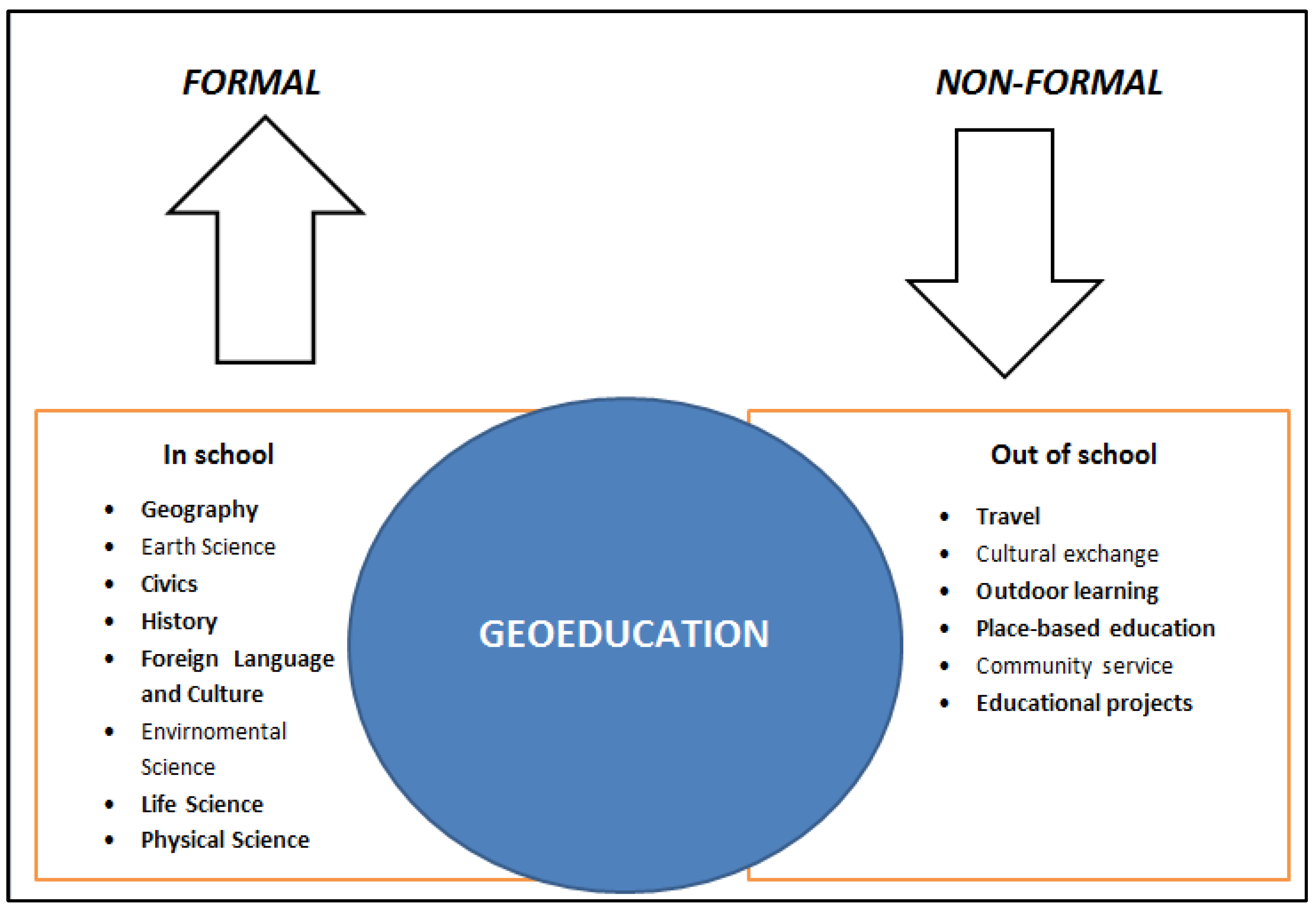
1. Introduction
2. Methodology
3. Results and Discussion
4. Conclusions
Author Contributions
Funding
Conflicts of Interest
References
- Pereira, P.; Pereira, D.; Alves, C.; Brilha, J. Geology, landscape and geomorphology: Finding the place of geomorphological heritage. In Proceedings of the IV International Symposium PROGEO, Braga, Portugal, 13–16 September 2005. [Google Scholar]
- Reynard, E.; Giusti, C. The landscape and the cultural value of Geoheritage. In Geoheritage: Assessment, Protection, and Management; Reynard, E., Brilha, J., Eds.; Elsevier: Amsterdam, The Netherlands, 2018; pp. 147–167. [Google Scholar]
- Stanley, M. Geodiversity—Linking people, landscapes and their culture. In Natural and Cultural Landscapes—The Geological Foundation; Parkes, M., Ed.; Royal Irish Academy: Dublin, Ireland, 2004; pp. 45–52. [Google Scholar]
- Panizza, M.; Piacente, S. Cultural geomorphology and geodiversity. In Geomorphosites; Reynard, E., Coratza, P., Regolini-Bissig, G., Eds.; Pfeil: Munich, Germany, 2009; pp. 35–48. [Google Scholar]
- Coratza, P.; Gauci, R.; Schembri, J.; Soldati, M.; Tonelli, C. Bridging natural and cultural values of sites with outstanding scenery: Evidence from Gozo, Maltese Islands. Geoheritage 2016, 8, 91–103. [Google Scholar] [CrossRef]
- Carreras, J.; Druguet, E. Geological heritage, an essential part of the integral management of world heritage in protected sites. In Geological Heritage and Its Conservation and Management, Proceedings of the Third International Symposium Pro Geo on the Conservation of the Geological Heritage, Madrid, Spain, 23–25 November 1999; Barretino, D., Wimbledon, W.A.P., Gallego, E., Eds.; Geological and Mining Institute: Madrid, Spain, 2000; pp. 95–110. [Google Scholar]
- Gray, J.M. Other nature: Geodiversity and geosystem services. Environ. Conserv. 2011, 38, 271–274. [Google Scholar] [CrossRef]
- Gordon, J. Rediscovering a sense of wonder: Geoheritage, geotourism and cultural landscape experiences. Geoheritage 2012, 4, 65–77. [Google Scholar] [CrossRef]
- Guichard-Anguis, S.; Heritier, S. Le patrimoine naturel entre culture et resource. Geogr. Cult. 2008, 66, 138. [Google Scholar]
- Migon, P. Geomorphological Landscapes of The World; Springer: Dordrecht, The Netherlands, 2010. [Google Scholar]
- Lowenthal, D. Natural and cultural heritage. Int. J. Herit. Stud. 2005, 11, 81–92. [Google Scholar] [CrossRef]
- Migon, P. Geoheritage and World Heritage sites. In Geoheritage: Assessment, Protection, and Management; Reynard, E., Brilha, J., Eds.; Elsevier: Amsterdam, The Netherlands, 2018; pp. 237–250. [Google Scholar]
- Pralong, J.P. A method for assessing the tourist potential and use of geomorphological sites. Géomorphologie 2005, 3, 189–196. [Google Scholar] [CrossRef]
- Coratza, P.; Giusti, C. Methodological proposal for the assessment of scientific quality of geomorphosites. J. Quat. Sci. 2005, 18, 307–313. [Google Scholar]
- Reynard, E.; Fontana, G.; Kozlik, L.; Scapozza, C. A method for assessing “scientific” and “additional values” of geomorphosites. Geogr. Helv. 2007, 62, 148–158. [Google Scholar] [CrossRef]
- Comănescu, L.; Ielenicz, M.; Nedelea, A. Relieful şi Valorificarea lui în Turism; Ars Docendi: Bucharest, Romania, 2010. [Google Scholar]
- Brilha, J. Inventory and quantitative assessment of geosites and geodiversity sites: A review. Geoheritage 2016, 8, 119–134. [Google Scholar] [CrossRef]
- Sellier, D. A deductive method for the selection of geomorphosites: Application to Mont Ventoux (Provence, France). Geoheritage 2016, 8, 15–29. [Google Scholar] [CrossRef]
- Bruschi, V.M.; Coratza, P. Geoheritage and environmental impact assessment (EIA). In Geoheritage: Assessment, Protection, and Management; Reynard, E., Brilha, J., Eds.; Elsevier: Amsterdam, The Netherlands, 2018; pp. 251–262. [Google Scholar]
- Ovreiu, A.B.; Comănescu, L.; Bărsoianu, I.A.; Nedelea, A. Evaluating geomorphosites and the geomorphological hazards that impact them: Case study—Cozia Massif (Southern Carpathians. Romania). Geoheritage 2019, 11, 1067–1087. [Google Scholar] [CrossRef]
- Gray, M. Geodiversity and geoconservation: What, why and how? In Geodiversity & Geoconservation; Santucci, V.L., Ed.; George Wright Forum: Hancock, MI, USA, 2005; Volume 22, p. 3. [Google Scholar]
- Gray, M. Geodiversity—Valuing and Conserving Abiotic Nature, 2nd ed.; Willey Blackwell: Chichester, UK, 2013. [Google Scholar]
- Stanley, M. Editorial. Geodiversity Update 2001, 1, 1. [Google Scholar]
- Geremia, F.; Bentivenga, M.; Palladino, G. Environmental geology applied to geoconservation in the interaction between geosites and linear infrastructures in South-Eastern Italy. Geoheritage 2015, 7, 33–46. [Google Scholar]
- Panizza, M. The geomorphodiversity of the Dolomites (Italy): A key of geoheritage assessment. Geoheritage 2009, 1, 33–42. [Google Scholar] [CrossRef]
- Comănescu, L.; Nedelea, A. Analysis of some representative geomorphosites in the Bucegi Mountains: Between scientific evaluation and tourist perception. Area 2010, 4, 406–416. [Google Scholar] [CrossRef]
- Gray, M. Geodiversity: Valuing and Conserving Abiotic Nature; John Wiley & Sons Ltd.: Chichester, UK, 2004; p. 434. [Google Scholar]
- Serrano, C.; Ruiz-Flano, P. Geodiversity: Concept, assessment and territorial aplication. The case of Tiermes—Caracena (Soria). Boletín Asoc. Geógrafos Españoles 2007, 45, 389–393. [Google Scholar]
- Zwoliński, Z.; Najwer, A.; Giardino, M. Methods for assessing geodiversity. In Geoheritage: Assessment, Protection, and Management; Reynard, E., Brilha, J., Eds.; Elsevier: Amsterdam, The Netherlands, 2018; pp. 27–52. [Google Scholar]
- Andrășanu, A. Geoconservarea—Concepte, Metodologie, Aplicații—Geoconservarea FormațIunilor de Vârstă Cretatic Inferior Din Bazinul Dâmbovicioara. Ph.D. Thesis, University of Bucharest, Bucharest, Romania, 2008. [Google Scholar]
- Brilha, J. Geoheritage: Inventories and evaluation. In Geoheritage: Assessment, Protection, and Management; Reynard, E., Brilha, J., Eds.; Elsevier: Amsterdam, The Netherlands, 2018; pp. 69–82. [Google Scholar]
- Berrebi, Y. Les Sentiers Didactiques: Analyse de la Perception du Public Face à Quatre Réalisations Géodidactiques, Mémoire de Licence; UNIL, Institut de Géographie: Lausanne, Switzerland, 2006. [Google Scholar]
- Sellier, D. La vulgarisation du patrimoine géomorphologique: Objets, moyens et perspectives. Géographies Bull. Assoc. Géographes Français 2009, 86, 67–81. [Google Scholar] [CrossRef]
- Cayla, N.; Hobléa, F.; Gasquet, D. Guide des bonnes pratiques de médiation des géosciences sur le terrain. Géologie Fr. 2010, 1, 47–55. [Google Scholar]
- Bollati, I.; Pelfni, M.; Pellegrini, L.; Bazzi, A.; Duci, G. Active geomorphosite and educational application: A didactical itinerary along Trebbia River (Northern Apennines, Italy). In Les Géosciences au Service de la Société; Reynard, E., Laigre, L., Kramar, N., Eds.; Institut de géographie, Université de Lausanne: Lausanne, Switzerland, 2011; Volume 37, pp. 219–234. [Google Scholar]
- Available online: https://www.nationalgeographic.org/education/geo-education-essential-preparation-interconnected-world/ (accessed on 1 September 2020).
- Bergner, A.; Bookhagen, B.; Ellger, C.; Schneider, S. GeoEd: Teaching teachers for a better GeoEducation in Germany. In Proceedings of the Conference: European Geosciences Union General Assembly, Vienna, Austria, 12–17 April 2015. [Google Scholar]
- Swiss Centre for Geomatics Education—Technically Committed to Shaping the Environment. Available online: https://geo-education.ch/?lang=en (accessed on 22 October 2020).
- African Network for Geo-Education. Available online: https://sites.google.com/site/geoeducationafrica/ (accessed on 22 October 2020).


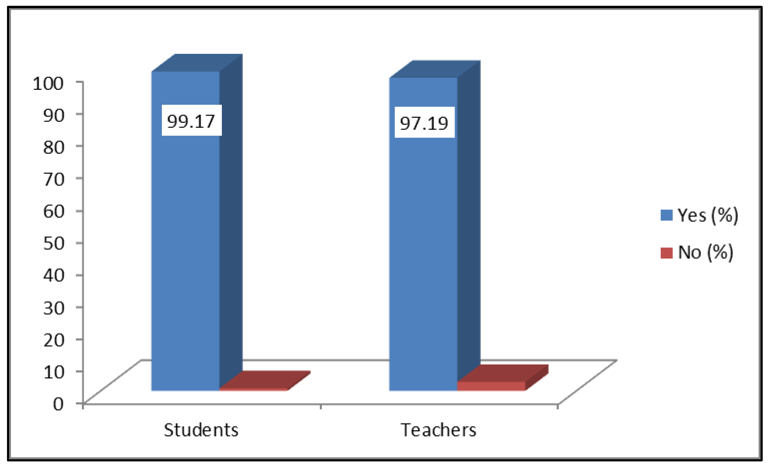
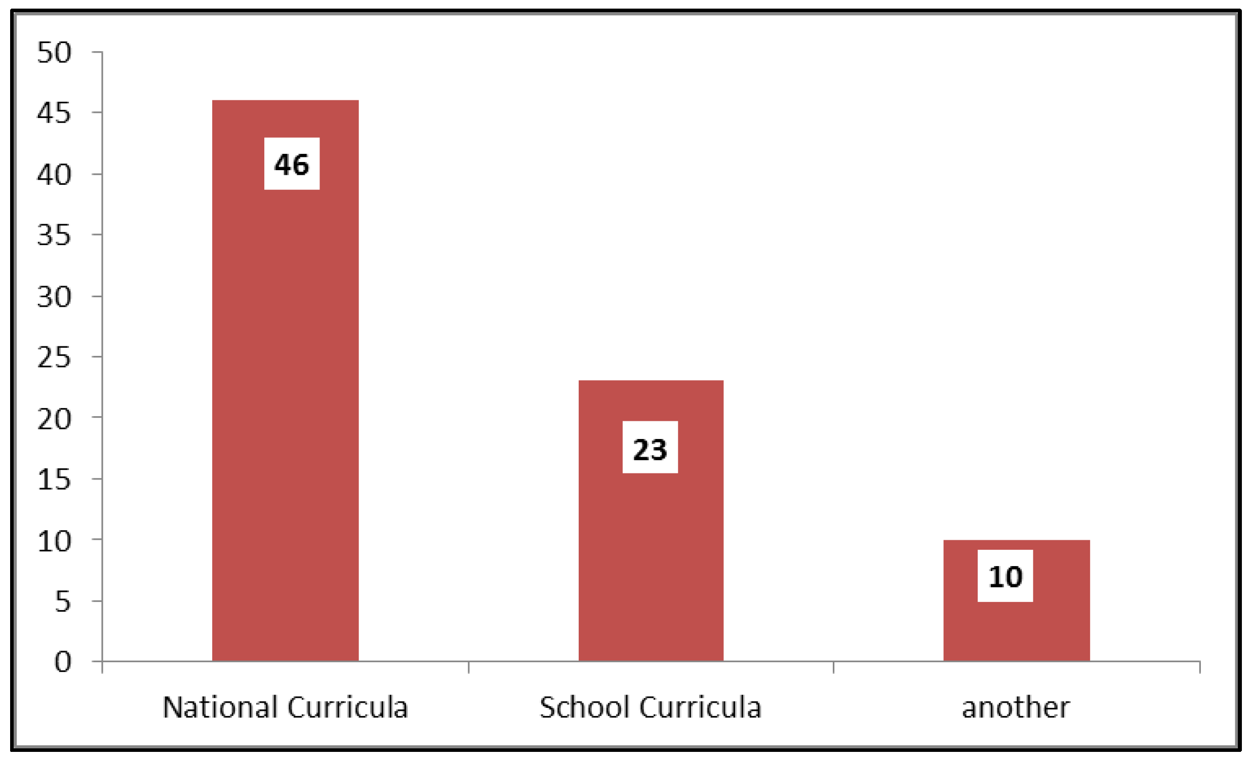
| I. Respondent’s file 1. The educational institution where you teach 2. Discipline taught 3. The study cycle you teach 4. Seniority in education II. General notions about geoheritage and geodiversity 1. Do you know and use the concept of natural heritage (geological and geomorphological)/geodiversity, or their synonyms)? -Yes -Not 2. Do you know and use the concept of biodiversity (or its synonyms)? -Yes -Not 3. On a scale of 1 to 10 (1—lowest, 10—highest), how important do you consider the concepts of natural heritage (geological and geomorphological) and geodiversity? | III. Teaching experience 4. Did you use these concepts (or their meaning) in your classwork? -Yes -Not 5. If so, in what context? -CN (national curriculum) -CDS (curriculum at the school’s decision) -Other types of activities 6. If you answered other types of activities, mention which ones. 7. If you answered CDS, mention the title of the optional subject and the class you are taking. 8. Do you think it would be useful to introduce such notions in the curriculum? -Yes -Not 9. If you answered yes, in what context (subject, year of study)? 10. What educational projects have you done/intended to do about natural heritage/geodiversity? |
| I. Respondent’s file 1. Higher education institution (University/Faculty) 2. Specialization 3. Bachelor’s/Master’s/Postgraduate courses 4. Year of study II.General notions about geoheritage and geodiversity 1. Do you know and use the concept of natural heritage (geological and geomorphological)? -Yes -Not 2. If so, from where? -Course/seminar (which?) -Further reading -Field trips -Other…. 3. Do you know and use the concept of geodiversity? -Yes -Not 4. If so, from where? -Course/seminar (which?) -Additional reading | -Field trips -Other………. 5. Do you consider it important to preserve the natural heritage? -Yes -Not 6. If yes, list 3 steps that should be taken for this purpose. III. Didactic component 7. Do you think that more subjects/contents related to natural heritage/geodiversity should be included in the curriculum? 8. Do you think that more non-formal activities should be carried out on this topic? 9. If you answered yes to the previous point, give 3 examples. 10. On a scale from 1 to 10 (1—lowest, 10—highest), how important do you consider the concepts of natural heritage (geological and geomorphological) and geodiversity? |
| Discipline Taught (%) | Study Cycle They Teach (%) | Seniority in the Department (%) | |||
|---|---|---|---|---|---|
| Geography | 88.36 | Lower secondary education | 41.66 | Less 5 years | 23.20 |
| Geography–History | 3.33 | Upper secondary education | 30.00 | 5–10 years | 17.30 |
| Geography–Biology | 0.83 | Mixed | 28.34 | 10–15 years | 8.30 |
| Geography–Chemistry | 0.83 | 15–20 years | 16.90 | ||
| Geography–Foreign Language | 0.83 | 20–25 years | 11.80 | ||
| Mathematics | 0.83 | More 25 years | 22.50 | ||
| Tourism | 0.83 | ||||
| Tourist Orientation | 0.83 | ||||
| Logic–Philosophy | 0.83 | ||||
| Technical disciplines | 2.50 | ||||
| Higher Education Unit from Which They Come (%) | The Study Cycles (%) | Specialization (%) | |||
|---|---|---|---|---|---|
| University of Bucharest | 85.9 | Bachelor | 43.6 | Geography | 52.21 |
| Ovidius University Constanța | 7.1 | Master | 32.4 | Geography of Tourism | 18.30 |
| University of Craiova | 1.4 | Post-graduate study | 24.00 | Geographic Information Systems | 5.63 |
| Hyperion University of Bucharest | 1.4 | Cartography | 2.80 | ||
| Valahia University of Târgoviște | 1.4 | Geomorphology and Cartography with Elements of Cadastre | 5.63 | ||
| Babeș—Bolyai University of Cluj Napoca | 1.4 | Integrated Environmental Assessment | 5.63 | ||
| Ștefan cel Mare University of Suceava | 1.4 | Management of Tourist Resources and Activities | 4.20 | ||
| Climatology and water resources | 2.80 | ||||
| Hydrology–Meteorology | 1.40 | ||||
| Disaster Management | 1.40 | ||||
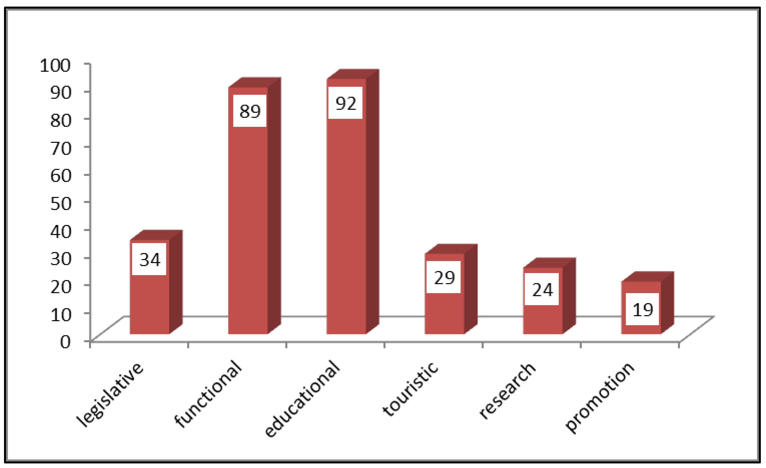
| Direction | Measures |
|---|---|
| Legislative |
|
| Functional |
|
| Educational |
|
| Tourist |
|
| Research |
|
| Promotion |
|
Publisher’s Note: MDPI stays neutral with regard to jurisdictional claims in published maps and institutional affiliations. |
© 2020 by the authors. Licensee MDPI, Basel, Switzerland. This article is an open access article distributed under the terms and conditions of the Creative Commons Attribution (CC BY) license (http://creativecommons.org/licenses/by/4.0/).
Share and Cite
Comănescu, L.; Nedelea, A. Geoheritage and Geodiversity Education in Romania: Formal and Non-Formal Analysis Based on Questionnaires. Sustainability 2020, 12, 9180. https://doi.org/10.3390/su12219180
Comănescu L, Nedelea A. Geoheritage and Geodiversity Education in Romania: Formal and Non-Formal Analysis Based on Questionnaires. Sustainability. 2020; 12(21):9180. https://doi.org/10.3390/su12219180
Chicago/Turabian StyleComănescu, Laura, and Alexandru Nedelea. 2020. "Geoheritage and Geodiversity Education in Romania: Formal and Non-Formal Analysis Based on Questionnaires" Sustainability 12, no. 21: 9180. https://doi.org/10.3390/su12219180
APA StyleComănescu, L., & Nedelea, A. (2020). Geoheritage and Geodiversity Education in Romania: Formal and Non-Formal Analysis Based on Questionnaires. Sustainability, 12(21), 9180. https://doi.org/10.3390/su12219180