Article

Communities’ Livelihood Vulnerability to Climate Variability in Ethiopia

1
The United Graduate School of Agricultural Sciences, Tottori University, 4-101 Koyama-Minami, Tottori 680-8553, Japan
2
Institute of Disaster Risk Management and Food Security Studies, Bahir Dar University, P.O. Box 79, Bahir Dar 6000, Ethiopia
3
Arid Land Research Center, Tottori University, 1390 Hamasaka, Tottori 680-0001, Japan
4
International Platform for Dryland Research and Education, Tottori University, 1390 Hamasaka, Tottori 680-0001, Japan
5
College of Agriculture and Environmental Sciences, Bahir Dar University, Bahir Dar 5501, Ethiopia
6
Faculty of Agriculture, Tottori University, 4-101 Koyama-Minami, Tottori 680-8550, Japan
7
College of Business and Economics, Bahir Dar University, P.O. Box 79, Bahir Dar 6000, Ethiopia
8
Department of Geography, San Diego State University, San Diego, CA 92182, USA
9
Faculty of Civil and Water Resource Engineering, Bahir Dar Institute of Technology, Bahir Dar University, P.O. Box 26, Bahir Dar 6000, Ethiopia
10
Faculty of Life and Environmental Science, Shimane University, Shimane Matsue 690-0823, Japan
*
Author to whom correspondence should be addressed.
Sustainability 2019, 11(22), 6302; https://doi.org/10.3390/su11226302
Submission received: 26 August 2019 / Revised: 30 October 2019 / Accepted: 7 November 2019 / Published: 9 November 2019
(This article belongs to the Special Issue Soil Erosion and Sustainable Land Management (SLM))

Abstract

:
Ethiopia has experienced more than 10 major drought episodes since the 1970s. Evidence has shown that climate change exacerbates the situation and presents a daunting challenge to predominantly rain-fed agricultural livelihoods. The aim of this study was to analyze the extent and sources of smallholder famers’ livelihood vulnerability to climate change/variability in the Upper Blue Nile basin. We conducted a household survey (n = 391) across three distinct agroecological communities and a formative composite index of livelihood vulnerability (LVI) was constructed. The Mann–Kendall test and the standard precipitation index (SPI) were employed to analyze trends of rainfall, temperature, and drought prevalence for the period from 1982 to 2016. The communities across watersheds showed a relative difference in the overall livelihood vulnerability index. Aba Gerima (midland) was found to be more vulnerable, with a score of 0.37, while Guder (highland) had a relatively lower LVI with a 0.34 index score. Given similar exposure to climate variability and drought episodes, communities’ livelihood vulnerability was mainly attributed to their low adaptive capacity and higher sensitivity indicators. Adaptive capacity was largely constrained by a lack of participation in community-based organizations and a lack of income diversification. This study will have practical implications for policy development in heterogeneous agroecological regions for sustainable livelihood development and climate change adaptation programs.

1. Introduction

1.1. Livelihood Vulnerability to Climate Change

A livelihood is a means by which individuals or households make a living [1]. Household livelihood outcomes are a function of a range of components, including livelihood assets, activities, processes, and structures. Smallholder farmers, accounting for 75% of the world’s agricultural area [2] and 60% of employment [3], produce over 80% of the food consumed in the developing world [4] and are one of the most vulnerable groups of people to climate change [5,6]. The vulnerability has been attributed to their high dependence on ecosystem services and goods, exposure and sensitivity to climate variability, low adaptive capacity, reliance on rain-fed livelihood activities, and often marginal locations in the landscapes [7,8,9]. Moreover, adverse consequences of environmental challenges (e.g., climate change) on crop sustainability and productivity could affect farmers’ livelihood activities and lower their adaptive capacity [10]. According to the Intergovernmental Panel for Climate Change (IPCC), climate change is projected to increase climate-related shocks (e.g., drought) and disproportionately manifest its adverse consequences through human health, food security, and water resources, specifically for rural poor households [11]. The IPCC report emphasized that efforts should focus on enhancing adaptation, reducing exposure, and decreasing the vulnerability of small-scale farmers while enhancing their resilience to shock impacts. These interventions in turn should be informed by evidence of livelihood vulnerabilities [12], which are shaped by physical, economic, social, and ecological factors and processes [13].
Livelihood vulnerability to climate variability and change is a function of exposure, sensitivity, and adaptive capacity [14]. Exposure refers to changes in climate variability explained by seasonal variations, and it is essentially associated with precipitation and temperature [15]. Sensitivity refers to the degree to which a system could be adversely affected, and it is explained by the potential impact’s net effect and people’s potential to cope with any adverse consequences. It essentially captures a system’s susceptibility to harm associated with environmental and social changes. Adaptive capacity entails the capacity of the system to withstand variability and changes in order to minimize potential damages, to cope with negative consequences, and possibly even benefit from these changes [11,13,16,17,18]. Several researchers have attempted to explore the blend between livelihood approaches and vulnerability dimensions as part of a broader study of sustainable livelihood development. Many studies in Africa and elsewhere have found varied results in terms of which factors contribute to overall livelihood vulnerability [19,20,21,22,23,24,25]. Other studies in this continent (e.g., [7,8,9]) have indicated that lower adaptive capacity and higher exposure to climate-related hazards (e.g., drought) are the major contributors to livelihood vulnerability and consequently undermine the sustainability of small-scale farmers’ livelihood bases.
To empirically understand livelihood vulnerability, the fundamental work by Hahn et al. [26] to assess community livelihood vulnerability in Mozambique is of great importance. Employing the Sustainable Livelihoods Approach [27], Hahn et al. used the IPCC-LVI (livelihood vulnerability index) to investigate communities in terms of their endowment of human capital, financial capital, physical capital, social capital, and natural capital. Environmental shocks and stresses (e.g., drought) related to climate change were viewed from the perspective of each of these types of capital. The methodology has since been applied to study communities and regions elsewhere in the developing world and Ethiopia and provides the foundation for this research as well [20,22,25,28,29,30,31,32,33].

1.2. The Ethiopian Context

Climate variability and change is repeatedly cited as the source of vulnerability in Ethiopia [34,35,36]. The country has experienced more than 10 drought events since the 1970s [9]; hence, sensitivities are also a product of large inter-seasonal climate variability and the reliance of the economy on rain-fed agriculture [37]. Vulnerability to climate variability is evident in terms of social and economic institutional sensitivity to variability in rainfall and the occurrence of extreme climate related shock events (e.g., drought and flood) [31,34,38]. The climate projections for 2040 to 2059 show a 1.8 °C increase in temperature and, with a higher inter-annual variability in the northern part, rainfall is anticipated to decline [39]. Therefore, as noted by Simane, Zaitchik, and Foltz [31], amalgamation of sensitivity to past climate variability and limited adaptive capacity in terms of socioeconomic and institutional aspects, coupled with the projections of anticipated future climate change, suggests that the country will be adversely affected by climate patterns in the years to come [39]. Ethiopia’s efforts to address the negative impact of climate variability are in the process of shifting from a technocratic perspective of climate and disaster science to long-term efforts at reducing livelihood vulnerability and attaining sustainable livelihoods [34]. The country’s effort to develop and operationalize the Climate Resilient Green Economy as a guiding strategy for climate change adaptation and mitigation efforts is a huge step forward in this regard [40].
Some research has been conducted to support policies and strategies to reduce the exposure and vulnerability of rural livelihoods to the effects of climate change/variability. In the Ethiopian highlands, Simane, Zaitchik, and Foltz [31] revealed that climate change vulnerability is context specific and agroecosystems should be at the centre of future studies. The authors found that midland areas are better off in terms of climate change vulnerability as compared to both high and lowland areas. A similar study in Tigray revealed that climate change exposure and low adaptive capacity were substantially associated, and moreover, they were the major causes of vulnerability among farming communities [29]. Similarly, in their comparative study of Ethiopian highlands, Siraw, Adnew Degefu, and Bewket [32] found that watersheds that received soil and water conservation works were less vulnerable to the effects of climate change than those that did not receive any. Owing to the above facts, there are still gaps in our study area where variations exist in agroecological locations, which indicates smaller scale studies are essential to better inform planners. Moreover, there are methodological gaps in the weightage procedure of indicators to measure vulnerability [13,41,42] and livelihood vulnerability studies need to emphasize one of the most important concerns of Ethiopian rural smallholder farmers, particularly drought [9].

1.3. Study Objectives

By applying the IPCC-LVI [26] at agroecologically contrasting environments, this study aimed at analyzing the livelihood vulnerability to climate change/variability for small-scale farmers in north western Ethiopia, Upper Blue Nile basin. First, the major objective of this manuscript is to provide empirical evidence at smaller scales of how livelihood vulnerability may vary across diverse agroecological ecosystems [43]. A second, and much more minor, objective is to address methodological gaps related to weightage of indicators so that robust conclusions can be drawn [13,41,42]. Lastly, we aim to shed light on the community level obstruction (constraints) indicators to limiting climate change/variability adaptive response mechanisms [44].

1.4. Significance of the Study

Despite being few in numbers, recently, livelihood vulnerability to climate variability/change studies have received growing attention in Ethiopia. Most of these studies were broader in scale and used political administrations (e.g., districts, regions, and national) as unit of analysis, while others focused on vulnerability to food insecurity and poverty. Almost all of them have adopted the LVI-IPCC livelihood measure, using subjectively evaluated indicators to construct the indices. However, studies at the national level are not believed to show the full picture of socioeconomic livelihood and the variability of other adaptive capacities at lower scales, and findings may not precisely indicate the necessary information for practical implications. Furthermore, these studies have underestimated the importance of studying past drought episodes on the current livelihoods of communities. The present study provides a sounder quantitative analysis of livelihood vulnerability using the Shannon entropy weighting procedure at a lower scale (watersheds in this study), whereby the locations represent contrasting agroecological environments. Therefore, in this study, we argue that small-scale farmer level studies would help to better understand the adaptive capacities of communities, and hence would help decision-makers tailor policies to the local conditions. Moreover, to further help fine-scale decision making at the community level, we adopted an obstruction degree analysis, which enabled us to bring up the specific constraint indicators of adaptive capacity that varied by study locations. Hence, the current study can be adopted for similar agroecological environments, watersheds, and communities in Ethiopia and other developing countries. More broadly, we also contribute to the limited existing literature of rural livelihood vulnerability analysis studies in Ethiopia and other developing countries. For instance, the methodology could be adopted for national level objective climate vulnerability studies and promotes the inclusion of climate related shocks as part of the analysis.

2. Materials and Methods

2.1. Study Area

This study was carried out in the following three different agroecological environments of the northwestern highlands of Ethiopia in the Upper Blue Nile basin: Guder (highland), Aba Gerima (midland), and Dibatie (lowland) (Figure 1). Area selection was determined by their differences in elevation, cropping system, and precipitation [45], and these three watersheds were selected because they represent a range of different agroecological and socioeconomic characteristics. Households in the study areas primarily make their livelihoods from a mixed crop–livestock production system. The major crops grown are barley (Hordeum vulgare L.), teff (Eragrostis tef Zucc.), wheat (Triticum aestivum L.), and potato (Solanum tuberosum L.) [46]. Cattle, sheep, goats, donkeys, and horses are the dominant livestock raised.
Aba Gerima watershed is categorized as humid sub-tropical, with an annual rainfall that ranges from 895 to 2037 mm. Guder is moist tropical, with an annual rainfall of 1951–3424 mm, and Dibatie is tropical hot humid, with an annual rainfall of 850–1200 mm [46]. Data from nearby meteorological stations shows that there has been notable climate variability since 1982 [47]. Despite being in different agroecological environments, the watersheds are characterized by similar rainy (June to October) and dry (November to May) seasons, and more than 86% of the rainfall is concentrated during the rainy season.
Most farmers in these areas have subsistence-based livelihoods supplemented by additional sources of non-and off-farm income. In the past decade, most farmers in Guder and Aba Gerima have shifted from growing food crops to growing green wattle (Acacia decurrens) (Wendl. f.) Willd. and khat (Catha edulis), respectively [48,49]. Notable droughts have occurred in these areas, for example, in 1984/1985, 1992/1993, 2000/2001, and 2015/2016 [9].

2.2. Data and Sampling Procedures

We used a mix of data collection methods and sources. First, meteorological data (temperature and rainfall) were gathered from the Ethiopian National Meteorology Station for the period from 1982 to 2016. Second, we conducted a participatory rural appraisal [27] to select the specific local indicators of livelihood vulnerability, as defined by the communities themselves. Twenty individuals from each community participated in this appraisal (for a total of 60). Third, we considered the newly identified livelihood vulnerability indicators and developed a draft questionnaire to be administered in a pilot test administered to five households in each watershed.
Finally, primary data were obtained from sampled respondents using a structured questionnaire administered in face-to-face interviews conducted in October and December 2018. The topics included sociodemographic profiles, food, water, social networks, livelihood strategies, health, and climatic shocks. To select sample households for the study, we used a two-stage sampling procedure. We first selected watersheds according to their agroecological and socioeconomic differences and household respondents from each watershed were selected randomly by using a probability proportional to size sampling procedure. Due to its simplicity, the purposive selection of the watersheds, and the proportional to size sampling, we followed and adopted Cochran’s representative size to proportions formula. Therefore, based on the sampling procedures of Cochran [50], we first calculated the required sample size to be 391 from the full household lists of all three watersheds. We then randomly selected 130 households from Aba Gerima, 132 households from Guder, and 129 households from Dibatie. The questionnaire was first developed in English and then translated into the Amharic language. Enumerators were trained on each question and practiced doing mock interviews. Under supervision, the enumerators interviewed each head of household (male or female). In the absence of the household head, elders who were willing to participate in the interview were interviewed. The first author did all the supervisory work and quality checks throughout the data collection period. On average, each interview took 60 min.

2.3. Data Analysis

This study generally followed the IPCC-LVI construction methodology, which is essentially based on a sustainable livelihood framework (SLF) [26]. Data management and analyses were performed with Stata ver. 15 (StataCorp LLC, College Station, TX, USA), MS Excel, and XLSTAT.

2.3.1. Meteorological Data Analysis

To understand the long-term trends of rainfall and temperature, we analyzed the climate variability/change and the significance of monotonic trends by using the Mann–Kendall (MK) test for long-term metrological records [51]. The MK test and Sen’s slope estimator (with Pettitt’s homogeneity test) were applied to the time-series data from 1982 to 2016 for the three watersheds.
The standardized precipitation index (SPI) was used to characterize historical drought patterns and periods in the study watersheds. The SPI uses a Z-score to explore unusual weather events that happened in the past. SPI is a normalized index in time and space and was computed following Thomas B. McKee [52]. To characterize drought intensity, the author suggested that SPI can be calculated on a time scale from 1 month to 72 months. For the purpose of this study, we chose a 3-month time scale to assess the main rainy season. We used statistical software developed by Tigkas et al. [53], called the Drought indices Calculator (DrinC), in the drought analysis.

2.3.2. Measures of Livelihood Vulnerability

We followed an inductive approach for the construction of an overall formative composite index where we could explore the community (watershed)-scale livelihood vulnerability based on SLF [27,54] and the pragmatic approach of Hahn, Riederer, and Foster [26]. Presently, many different composite index constructions are usually criticized for their subjective weighting procedures because they may result in misleading information [55,56]. Including the pioneering work by Hahn et al., scholars in Ethiopia and elsewhere in the world followed the subjective weighting of components/indicators to construct the composite index. This is based on the number of questions included under the indicated component, which is inappropriate whereby the information is not quantitative, exclusive, and partial or incomplete. Unlike the subjective methods, in this study, we applied an objective weighting procedure by which it is more appropriate to give precise evidences for prioritizing planning areas (based on the value of sub-components), which seeks attention and remedies to reducing the livelihood vulnerability of communities to the adverse effects of climate variability/change. The Shannon entropy method, an objective weighting method that has been recommended as robust [20,22,57], was used to generate an evaluation score for each indicator. The following computation procedures were used (for a more detailed description of the procedures, see the Supplementary Materials): (1) We standardized all 33 indicators (as provided in Table 1 in the results section) by using a dimensionless processing technique that helps facilitate easy comparison of score values. In this case, the variables have a positive functional relationship with vulnerability, and a higher value is generally understood to indicate greater vulnerability. (2) The proportion of indicators in an evaluation matrix was computed. (3) An individual entropy value for each indicator was calculated. (4) The entropy weight for each indicator was computed. (5) A comprehensive index value was constructed for each community. The minimum value was scaled to 0 (least vulnerable) and the maximum was scaled to 1 (most vulnerable) (see the Supplementary Materials for more details).
In the results, we found that adaptive capacity was the most salient factor influencing overall IPCC-based livelihood vulnerability in the combined study area. As a result, we additionally followed a weighting and aggregation procedure for this dimension. Williams et al. (Williams, Crespo, Abu, and Simpson) [42] suggested that, in Africa, the adaptive capacity dimension of smallholder farmers’ livelihood vulnerability assessments should be emphasized to better inform decision-making. Therefore, we adopted a degree of obstruction model [44] to discover which factors limit adaptive capacity (see the Supplementary Materials for more details). A higher value (percentage points) indicates that the indicators could have a higher hindering capacity in terms of limiting households’ capacity to respond to the effects of climate change. This model is widely applicable in urban land-use management as a mathematical decision approach [58].

3. Results

3.1. Vulnerability Indicators

Profiling of livelihood vulnerability indicators was documented and analyzed for the three contrasting agroecological environments. Table 1 presents descriptions and summary statistics of vulnerability indicators used for the development of IPCC-LVI. It highlights the major differences between the three research areas in regards to climate, demographics, livelihoods, and other metrics. These differences allow for analysis and discussion of how livelihood vulnerability may vary in different agroecosystems. Guder had the highest deviation from the rainfall trend (87.1 mm), as compared to Aba Gerima (44.8 mm) and Dibatie (43.4 mm). The highest values for both average minimum (14.6 °C) and maximum temperatures (28.1 °C) were recorded in Dibatie (p < 0.001), which also had the lowest SPI and the most drought episodes. Aba Gerima (79.2%) had the highest proportion of households who did not attend school and the highest proportion of households (96.2%) with members who work outside their community. A larger percentage of sampled households in Dibatie (65%) did not participate in natural resource management works (p < 0.001) as compared to the other two communities. More households reported chronic illness in Dibatie (49.6%) as compared to the other sites (p < 0.001), and Dibatie households reported less contact with the local government offices for any kind of service (p < 0.001). Households in Aba Gerima reported more water-related conflicts as compared to Dibatie and Guder, and they also had the highest percentage (37%) of households who did not save seed for the next growing season. Most households in Aba Gerima (95.4%) and Dibatie (91.5%) reported that their own farm was their main source of food, whereas the proportion was lower in Guder (74.2%) (p < 0.001). From the participatory rural appraisal, communities in all three watersheds were able to bring two new indicators to be used as part of the overall IPCC-LVI. These indicators were environment related indicators; namely, the level of household participation in natural resource management works and the soil erosion status in their farms. These indicators showed significant difference amongst the study watersheds (p < 0.001).

3.2. IPCC-Based Livelihood Vulnerability

In terms of overall IPCC-LVI, Aba Gerima was found to be more vulnerable, with an aggregate score of 0.37 (on a scale of 0 to 1), followed by Dibatie and Guder at 0.35 and 0.34, respectively (Figure 2a). The adaptive capacity of smallholder farmers made the greater contribution relative to the other dimensions in terms of explaining livelihood vulnerability (0.15, 0.14, and 0.13 in Aba Gerima, Guder, and Dibatie, respectively), followed by sensitivity (0.14, 0.12, and 0.13) and exposure (0.08, 0.08, and 0.09) (Figure 2b).

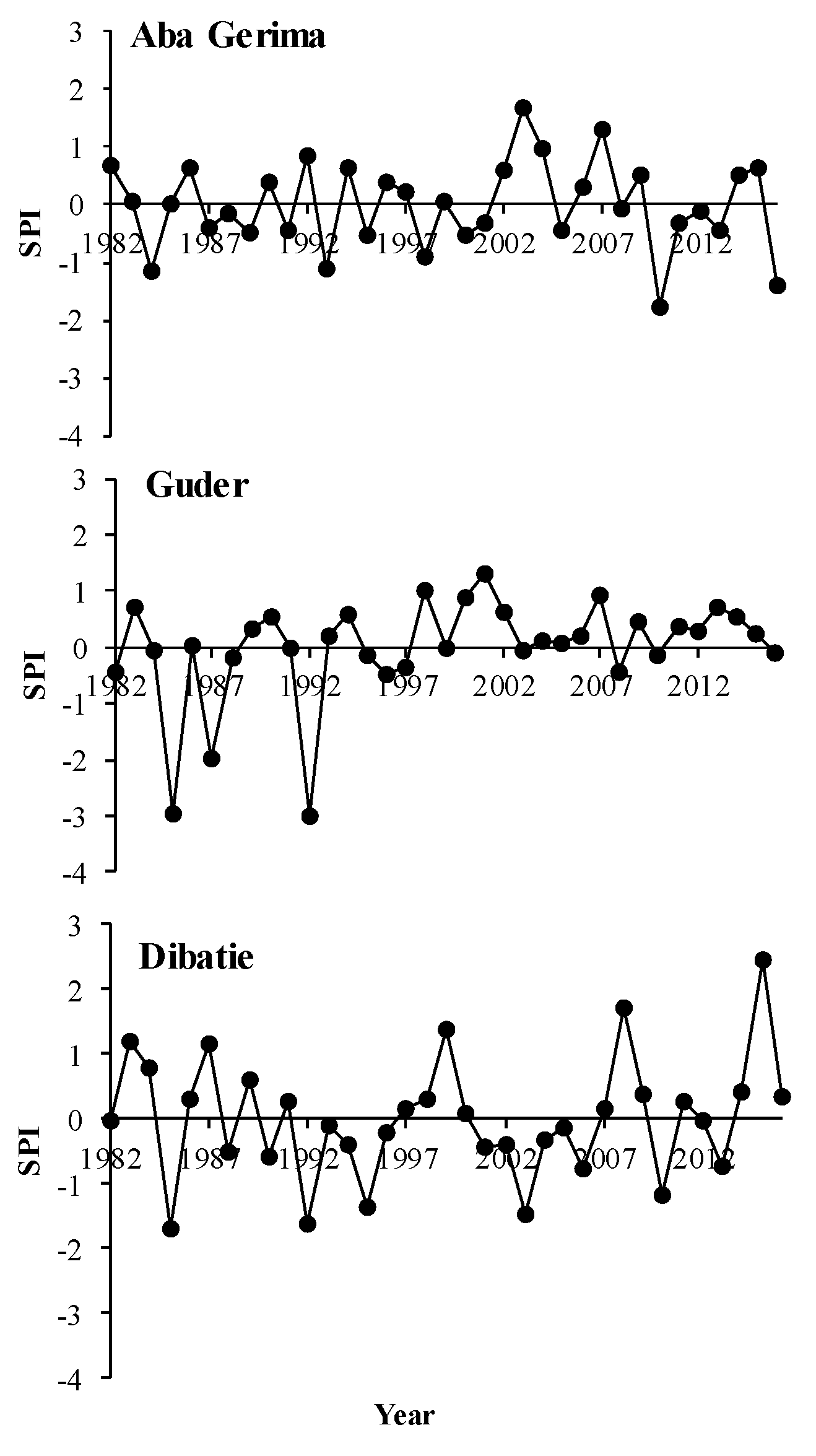
3.2.1. Exposure to Climate Shocks

Figure 3 shows the climate exposure trends (rainfall and temperature) in the three agroecological areas. In the IPCC-LVI, the exposure score at Dibatie was slightly higher (0.09) than that of both Aba Gerima and Guder (0.08). This dimension was aggregated from rainfall and temperature data, the number of climate-related shocks, household access to warning information about these shocks, and SPI. Although there was no significant SPI trend in the watersheds, there has been recurrent drought episodes at the Dibatie and Aba Gerima sites (Figure 4). Climate variability anomalies, as measured by SPI, made a substantial contribution to the exposure to livelihood vulnerability in Dibatie and Aba Gerima. Conversely, although Guder experienced relatively severe drought episodes in 1984/1985, this watershed has been less vulnerable to rainfall deficits since then. A higher temperature and lack of access to warning information made a notable contribution to the overall exposure in Aba Gerima (Table 1).
The mean annual rainfall of Aba Gerima was 1482.5 mm, with a SD of 178.6 mm and a coefficient of variation (CV) of 12.1%. The value was much higher in Guder (2145.3 ± 395.3 mm, CV = 18.4%) and lower in Dibatie (1339.5 ± 150.1 mm, CV = 11.20%). The average monthly temperature decreased from lowland to highland; that is, in the order Dibatie > Aba Gerima > Guder (Figure 3). Dibatie had more hot years, with the average maximum and minimum ever-recorded temperature of 21.9 °C in 2015 and 20.0 °C in 1985. The average maximum ever-recorded annual temperature in Guder was 18.2 °C in 2015 and the minimum was 15.8 °C in 1993. The Mann–Kendall test showed no significant long-term monotonic trend in the rainfall amount, with Z c of 1.3, 0.9, and 0.4, for Guder, Aba Gerima, and Debatie watersheds, respectively (Table 2, Figure 3) in the study watersheds. Similarly, Pettitt’s test showed strong homogeneity in annual rainfall in the three watersheds, indicating that annual rainfall did not change significantly over the study period (Table 2, Figure 3). Therefore, the null hypotheses Hoa and Hob for the two tests for annual rainfall in the three watersheds were accepted. In contrast, the watersheds showed a significant increasing trend in temperature during the study period (p < 0.05). The Z_c values of 3.92 in Guder, 2.07 in Aba Gerima, and 4.55 in Dibatie confirmed that there were significant changes in annual temperature over the study period (Table 2). The mean annual temperature increased by 0.04 °C per year in Guder watershed, 0.02 °C per year in Aba Gerima, and 0.03 °C per year in Dibatie from 1982 to 2016.
The three watersheds experienced drought episodes with varied intensities (Figure 4). For example, 1984/1985, 1992/1993, and 2015/2016 were recorded as drought years of moderate intensity for Aba Gerima watershed, but 2003/2004 and 2007/2008 were very wet and moderately wet years, respectively. Guder and Dibatie also experienced severe drought in 1984/1985 and1992/1993, but 2001/2002 was very wet. Dibatie also experienced drought in 1994/1995, 2003/2004, and 2010/2011. Except Guder, the MK trend test showed a decrease in SPI values across two other watersheds, suggesting a frequent drought incidence at a 3-month (Ethiopian summer) time scale, but there was no statistical evidence of any positive or negative trend. However, we can still justify that there have been recurrent drought episodes in Dibatie and Aba Gerima sites.

3.2.2. Sensitivity

Aba Gerima had the highest score for the sensitivity dimension of the IPCC-LVI (0.14), followed by Dibatie (0.13) and Guder (0.12) (Figure 2). Combined across all three watersheds, the food component had a higher score than the water and health components (Figure 5), particularly in Guder (0.07). Crop diversification (0.03) and on-farm food source (0.02) were the main contributors among the five indicators that made up the food component. In Aba Gerima, reliance on on-farm agriculture (0.03) and a low tradition of saving seed (0.01) substantially contributed to the overall sensitivity score. Compared to Aba Gerima (0.006) and Dibatie (0.007), Guder had a lower level of lower crop diversification (0.028). Guder also had a relatively low contribution from the health component (0.025) as compared to Dibatie (0.042) and Aba Gerima (0.048). In addition, inconsistent access to water (part of the water component) played a relatively higher role in Dibatie (0.025) and Aba Gerima (0.021) relative to Guder (0.014).

3.2.3. Adaptive Capacity

A slightly higher vulnerability due to lower adaptive capacity was revealed in Aba Gerima (0.15) as compared to Guder (0.14) and Dibatie (0.13). The livelihood strategies component had the highest contribution (0.052) in Aba Gerima, followed by the sociodemographic (0.046) and social networking (0.042) components. Overall, literacy status (0.024) contributed the most to aggregate adaptive capacity, followed by age (0.0173) and livestock ownership (0.0171). In Guder watershed, low adaptive capacity was attributable to households’ restricted options for livelihood strategies (0.050) and low sociodemographic characteristics (0.040). Social networking (0.052) had the greatest contribution in Dibatie, but a lack of contact with the local government office (0.024) contributed to their lower adaptive capacity.

3.3. Factors Obstructing Adaptive Capacity

Overall, availability of a higher number of dependents, low participation in community-based organizations (CBOs), a higher borrowing-lending ratio, and being a female-headed household were the most important limiting factors for adapting to climate change. In Aba Gerima, the top three indicators obstructing a household’s adaptive capacity were the dependency ratio (9.8%), a low degree of participation in CBOs (9.0%), and fewer household members working outside the community (9.0%). In Guder, the main factors were the dependency ratio (9.8%), low participation in CBOs (9.1%), and a higher borrowing-lending ratio (8.9%), and in Dibatie, they were dependency ratio (9.4%), lack of other sources of income (9.0%), and a higher borrowing-lending ratio (8.6%) (Figure 6).

4. Discussion

4.1. Livelihood Vulnerability Index

Communities in all three watersheds were vulnerable to the adverse effects of climate change variability because of high exposure, high sensitivity, and low adaptive capacity. In relative terms, Aba Gerima (midland) watershed was found to be the most vulnerable and Guder (highland) the least. The total score for Aba Gerima was 0.37, with 0.15, 0.14, and 0.08 contributed by adaptive capacity, sensitivity, and exposure, respectively. The corresponding scores for Dibatie were 0.35, 0.13, 0.13, and 0.09 and for Guder, they were 0.34, 0.14, 0.13, and 0.08. Interestingly, despite the very different contexts on each of the three communities, they showed relatively similar scores in the dimensions of the IPCC-LVI. Conversely, in their national scale study Ferede, Ayenew, Hanjra, and Hanjra [43] noted that the highland part of Ethiopia is more vulnerable compared to other agroecological zones. A possible reason for the two differences could be emanated from the scale of unit of analysis, whereby we used a watershed scale which helped us to gain the necessary details about livelihood vulnerability. Moreover, we also showed that adaptive capacity had relatively higher contribution for the overall livelihood vulnerability compared to its counterparts.
Aba Gerima was found to be the most vulnerable area, mainly because of its limited adaptive capacity and higher sensitivity. The sensitivity may be a result of the area’s severe soil erosion status and the fact that households are not sufficiently participating in sustainable land management activities. In the same study area, References [46,59] found that the community’s lower economic adaptive capacity affected its adoption of natural resource management practices. Ecological indicators such as soil depletion have also been shown to contribute to the vulnerability of village communities in Tanzania and South Africa [60]. In contrast, Guder was relatively less exposed to climate-related shocks. We found few drought episodes and an increasing rainfall trend in this area, so it is possible that communities in this watershed were less exposed to drought episodes and did not experience water shortages. An agroecological-based climate change vulnerability study in the Ethiopian highlands also found that highland agroecosystems are relatively less vulnerable to climate change shocks [31].

4.2. Exposure

Although the study area has had increasing rainfall, the trend was not significant at any of the sites. The watersheds studied have a unimodal rainfall pattern, and the rainy months occur mostly during the summer season (usually from mid-June to mid-September). Temperature did show a significant increasing trend at the study sites. Berihun, Tsunekawa, Haregeweyn, Meshesha, Adgo, Tsubo, Masunaga, Fenta, Sultan, and Yibeltal [47] also found that station data showed a significant upward trend in temperature but not rainfall in north-western Ethiopia. Moreover, Fenta et al. [61] also did not observe a monotonic trend in rainfall time series data in Ethiopia, and Teshome [62] found an increasing temperature trend in the Dembia District in the Upper Blue Nile basin. Furthermore, our findings are in line with other similar studies, which revealed observed trend changes in the Ethiopian highlands and elsewhere, with a mean annual temperature increase range between 0.028 °C and 1.65 °C from 1955 to 2016 [63,64]. In contrast, Samy et al. [65] reported a significant decreasing trend in rainfall in the southwestern part of the Upper Blue Nile basin. SPI results indicated that all the three watersheds were affected by drought episodes in 1984/1985, 1987/1988, 1992/1993, 2000/2001, 2010/2011, and 2015/2016, which is in line with other research results of drought experiences in Ethiopia [9,66]. Similarly, in their work in the northern part of Ethiopia, Kasie et al. [67] indicated that household livelihood systems were very much connected to the increment in their income, and this has been hurdled by the recurrent drought episodes (e.g., the 2015 El Niño).
Communities in Guder were found to be less exposed to climate-related shocks in five indicators (mean annual rainfall, mean annual maximum temperature, mean annual minimum temperature, number of shocks, and access to warning information). This could be partly attributed to the fact that the area has received more rainfall than the others (Figure 3). Moreover, despite experiencing drought episodes in 1984/1985 and 1992/1993, the watershed had a positive SPI and an increasing rainfall tendency in the study period. In Ethiopia, rainfall is crucial for predominantly rain-fed agriculture; hence, having more years of normal rainfall and more rainy days means better production and productivity for small-scale farmers [38]. In turn, having better agricultural productivity may enhance the adaptive capacity of the people. This result is in line that of with Simane, Zaitchik, and Foltz [31] who reported that highland agroecological systems were relatively less exposed to the effects of climate variability. Despite the higher amount of rainfall, Guder has had less exposure to soil erosion problems, which could be attributable to the unprecedented expansion of A. decurrens plantations across the watershed in the past decade [49]. The plantations might have helped the watershed by restoring the ecosystem of degraded hillsides and intercepting rainfall [68]. In addition, the contribution of agroforestry to rural livelihood resilience was noted in Quandt et al. [69], who showed the contribution of agroforestry in response to the impacts of climate-related hazards like drought and flooding. For example, during drought, many tree species still produced fruit for household consumption and sale, while staple food crops, such as maize, did not survive.
As compared to Guder and Aba Gerima watersheds, Dibatie watershed has been more exposed to climate-induced shocks and experienced more anomalies in the last 35 years. Despite that this watershed is located in a regional state known for its forest resources, it has been subject to overgrazing, deforestation, and poor farming practices, which has advanced desertification in the Nile basin (UNDP, 2017) [70]. Our findings are not in agreement with those of Deressa, Hassan, and Ringler [8], who revealed that households in Benishangul Gumuz had experienced fewer numbers of droughts and floods. A possible reason for this difference could be that they did not use station-level data to study vulnerability, whereas our SPI analysis did, and it showed that the area has experienced some types of meteorological and agricultural drought in the past 35 years. The SPI for Dibatie indicated relatively high climate variability, particularly dry spells and a significant increasing temperature trend (p < 0.001), which might have had negative impacts on crop production and livestock rearing. Late and untimely rainfall arrival in lowland agroecosystems and/or high temperatures during the crop development stage could cause a decline in yield and increase the community’s exposure and ultimately contribute to increased vulnerability [14]. Rurinda et al. [71] noted that increased rainfall variability together with rising temperatures reduces soil moisture availability and increases the risk of crop failure.

4.3. Sensitivity

The overall sensitivity score, which included the health, food, and water components, was lower than the overall adaptive capacity score for all three watersheds. The food component was the primary contributor in all three cases. A study carried out in Myanmar similarly revealed the food component substantially contributed to the sensitivity dimension of farm households’ climate change vulnerability [72]. A slightly higher sensitivity score was estimated for the Aba Gerima watershed as compared to Guder and Dibatie, which was mainly attributable to its sensitivity to the food and health components. Aba Gerima farmers generally had a lower level of food source diversification, which could trigger enhanced sensitivity. In addition, in Aba Gerima, land is being utilized to expand production of khat, which reduces the amount of land available for food production [48]. Moreover, no access to agricultural technology, a high degree of water abstraction from ground water aquifers for khat fields, and higher soil erosion severity also could have played roles in the sensitivity of households in this study site. Similarly, a higher livelihood sensitivity associated with landscape greenness, soil fertility, soil erosion, water availability, pasture availability, and plot condition was reported by Siraw, Adnew Degefu, and Bewket [32] in the Ethiopian highlands.
Dibatie scored better on crop diversification as compared to its counterparts. Crop diversification should make household livelihoods less sensitive to climate-related adverse effects. The Benishnagul Gumuz region, particularly Dibatie, besides other crops, has a notable tradition of ground nut cultivation [73], which is well known as a drought-resistant crop [74]. Dibatie, however, also had a relatively higher contribution from the soil erosion and seed-saving indicators. Ebabu et al. [75] and Abeje, Tsunekawa, Adgo, Haregeweyn, Nigussie, Ayalew, Elias, Molla, and Berihun [48] also reported that this watershed had higher land degradation problems as compared to Aba Gerima and Guder. Guder, representing the highland area, had lower crop diversification and, consequently, is relatively more sensitive to the effects of climate-related shocks. Saving seed for the next growing season is also not often practiced in Aba Gerima and Guder watersheds. This could possibly be related to their shift to the more remunerative cash-based khat plantation and A. decurrens monocropping [48].
Health-related problems made a greater contribution to the sensitivity dimension in Dibatie and Aba Gerima as compared to Guder. Community discussion participants at both of these sites reported that government health services in their proximity do not work properly, and they usually use private health services in the nearest town, which usually costs more than the government services. More household members were reported to miss school due to health problems in Dibatie, which is most likely related to their greater experience with chronic illness. Health problems could result in a shortage of family labour for operating agricultural lands. A similar study in Ghana revealed that the sensitivity of farmers to the impacts of climate variability was partly contributed from their higher exposure, especially in households who do not own enough livelihood capital to support agricultural labour [24].
The water component comprised consistent water access, water resource conflict, and average time to fetch water. Guder was relatively better off than the other two watersheds, and its lower sensitivity score might be associated with recent improvements in its broader ecosystem, and the presence of A. decurrens plantations and other sustainable land management activities [48,49,68]. Excessive extraction of water for irrigating khat farmlands could serve as a potential point of conflict among downstream and upstream farmers. Farmers in Aba Gerima reported that they had no consistent access to water sources, and the time it took them to fetch water was longer as compared farmers in the other watersheds. Moreover, the distance from the river to their farms was somewhat longer, which largely limited their ability to irrigate their farms. Whereas irrigation directly minimizes the impacts of climatic stresses such as droughts, farmers at all three sites are at increased risk of water availability due their dependence on natural water sources. A similar study noted a more pronounced livelihood vulnerability to drought in rural Iran, and it was mainly associated with access to water sources [76].

4.4. Adaptive Capacity

Adaptive capacity plays an essential role in responding to the adverse impacts of climate change/variability, reducing livelihood vulnerability, and helping people to achieve sustainable livelihoods [77]. Communities in all three watersheds were significantly less able to adapt to the effects of climate change. A household’s endowment of essential livelihood assets contributes to its adaptive capacity, which ultimately determines its livelihood vulnerability to certain negative consequences. Overall, communities in Aba Gerima were found to be more vulnerable, in a large part because of their low adaptive capacity, which was mainly attributable to limitations in the livelihood strategies and sociodemographic components. These components were, in turn, made up of elements, such as a relatively higher rate of illiteracy, higher age, and lower rate of engagement in livestock rearing. Possible reasons for lower livestock production may be a reduced availability of feed and restrictions on grazing in some parts of the watershed [78]. Their lower engagement in livestock rearing may also be associated with their larger family size and their relative affluence due to their proximity to Bahir Dar city and their greater engagement in the production of cash crops (i.e., khat). In a study conducted in Kenya, livestock diversification was shown to be an important indicator in terms of lowering sensitivity to multiple stresses related to climate change [23]. Even though the Dibatie (lowland) watershed exhibits a slightly better adaptive capacity as compared to the other two sites, in part because of its better social networking component score, households had little contact with local government offices, which ultimately constrained their institutional adaptive capacity to climate change vulnerability. Government offices are responsible for services related to response to climate-related shocks, such as issuing warnings, training residents about climate-smart technologies, providing information about markets, and delivering inputs. Hence, weaker contact with government offices may negatively affect the provision of these services. In addition, as we learned from the community discussions, most of the interviewed households are not entitled to own land, and thus cultivate land through informal renting arrangements. Land tenure insecurity has been cited as one of the constraints of production and productivity for households in Benishangul Gumuz [79,80]. In addition, effective, timely, and appropriate delivery of climate related warning information is of greater advantage at lower levels of administration (e.g., district level) planning and decision making for adaptation planning in the Ethiopian case [81]. In a similar study done along the Nile basin, access to climate related information was indicated as a significant driver for household adaptation to the adverse effects of climate variability/change [82].
A lower extent of livelihood diversification contributed to lower adaptive capacity in the Guder and Aba Gerima watersheds, possibly because the wider coverage of A. decurrens and khat plantations in these areas reduced the amount of land that could have been used for the production of food crops [48]. Climate variability in the form of drought could have more impact on communities with less diversified livelihood strategies [83]. A study of weather shocks in Ethiopia indicated that off-farm livelihood diversification enhanced the capacity households to cope with climate-related shocks [38]. A similar study in Kenya revealed that, as part of adaptive capacity, short- and long-term climate change adaptation should be supported by CBOs and enhanced social networking [19]. Communities in Guder showed a relatively high level of vulnerability in terms of participating in farmer-based organizations and a lack of communication devices to receive climate-related information. Rural community awareness on the causes and impacts of climate calamities on their lives and livelihoods can be improved by education. In addition, the more educated community members are, it is highly likely that they will adopt climate smart technologies [11]. Guder had a relatively higher education level, which indicates communities in this area should be more likely to adapt to the effects of climate change. A similar study carried out by Deressa et al. [84] indicated that level of education plays an essential role in terms of choice of climate adaptation strategies and, hence, affects livelihoods. Likewise, low literacy was shown to contribute to higher vulnerability of households in Ghana [24].

4.5. Obstruction Factors of Communities’ Adaptive Capacity

A larger number of dependents, low degree of participation in community based organizations (CBOs) and farmer-based organizations (FBOs), and lack of contact with the local government were major obstacles limiting community adaptive capacity. Moreover, being a female-headed household, not having other sources of income, and having a shortage of family labour were also major obstacles in all studied watersheds. As climate change/variability puts households under extra pressure, households with a shortage of labour could be more vulnerable by limiting their ability to diversify their income sources or go outside the community for employment. The availability and quality of human capital, including active working labour, has been shown to affect household adaptive capacity to climate change [85]. A lower degree of participation in community- and farmer-based organizations was a substantial obstacle, primarily because these organizations provide important services to the communities. For example, CBOs include informal social networking schemes where households help each other during periods of social, as well as economic, problems. Social networking essentially reduces a community’s vulnerability to the adverse effects of climate change [86]. Female-headed households generally have a marginal role in all walks of life and are denied many opportunities, which makes them more vulnerable to the effects of climate change [87]. Female-headed households may not have access to social services and information because of socially constructed problems related to inequality, and this could limit their capacity to mobilize available resources to adapt to the negative effects of climate-related shocks them [66,84]. Similarly, a gender specific study in Ghana revealed that female headed households, due to their low sociodemographic profile, low social network, and lack of access to water and food, were indicated as vulnerable to the impacts of climate change/variability compared to their counterparts[88]. Moreover, in Central Nepal, limited access to communication and reliable information on climate related hazards and low participation in local based organizations made female head households vulnerable [89].

5. Conclusions and Implications

As a consequence of the great heterogeneity in socioeconomic capacity and livelihoods across different communities, similar exposure to climate variability and climate change poses differential impacts on different groups of people at different scales. Rural households in the Upper Blue Nile basin rely on rain-fed agriculture for their livelihoods. This sector is vulnerable and sensitive to the risks and impacts of climate-related shocks/hazards, particularly considering the accumulated negative effects of past droughts. This study aimed to analyze the vulnerability of smallholder farmer livelihoods to climate change/variability in three watersheds of the Upper Blue Nile basin in Ethiopia. We developed and applied a multi-indicator and quantitative methodology that helped show the relative livelihood vulnerability differences among agroecologically different watersheds as a function of exposure, sensitivity, and adaptive capacity. To compute more precise indices, we utilized Shannon’s entropy evaluation computation to assign objective weights to the proxy indicators that made up the composite index.
Temperature showed a significant increasing trend over the 35-year study period. Extreme drought episodes were more pronounced in Guder (the highland). In contrast, Aba Gerima (midland) and Dibatie (lowland) experienced more frequent drought episodes. Drought episodes were observed in 1984/1985, 1987/1988, 1992/1993, 2000/2001, 2010/2011, and 2015/2016 in all study watersheds, which is consistent with the national historical record.
In terms of the overall IPCC-LVI score, Aba Gerima was found to be relatively more vulnerable, with a score of 0.37. With similar exposure to climate variability, communities’ livelihood vulnerability was mainly attributed to their low adaptive capacity and higher sensitivity to proxy indicators. Guder had the lowest IPCC-LVI score (0.34). Smallholder farmers’ adaptive capacity contributed the most, relative to other dimensions, in terms of explaining livelihood vulnerability, with scores of 0.15, 0.14, and 0.13 in Aba Gerima, Guder, and Dibatie, respectively. Dibatie watershed, representing the lowland agroecological setting, had the greatest contribution from the exposure dimension (climate-related indicators) as compared to the other two sites. Results indicated that communities with more diversified livelihood strategies are less vulnerable to the impacts of climate change. The obstruction degree analysis showed that some indicators were turned out to have constrained the adaptive capacity of communities to climate variability effects. These indicators include, but are not limited to the availability of a higher number of dependents and being a female-headed household, low participation in CBOs, lack of alternative income sources, and less engagement in community borrowing and lending cultural practices. In this study, by adopting the Shannon entropy weightage procedure, we tried to address the challenges of subjective measurement of livelihood vulnerability to better inform interventions actions.
Given the predominant rain-fed agricultural system in the Upper Blue Nile basin, enhancing adaptive capacity and mitigating sensitivity should be prioritized to help communities adapt to the adverse impacts of climate change. For example, empowerment of female-headed households (e.g., by improving their livelihood bases, increasing their social role, etc.) will enhance their social position, increase their opportunities, and help reduce their vulnerability. Diversifying livelihood options and food sources will also help reduce sensitivity.
This study has practical implications for agroecological heterogeneous policy development and program design in sustainable livelihood development and climate change adaptation programs. More specifically, it will have practical implications by filling the gap between the broader theoretical aspect of livelihood vulnerability to climate change to the day to day decision making at lower administration and planning scales. In addition, providing sound scientific evidence employing objective weighting and appropriate aggregation procedures will not only further improve livelihood vulnerability analysis methods, but also has practical implications for providing better information in the prioritization of countermeasures to address factors that contribute to vulnerability.

Supplementary Materials

The following are available online at https://www.mdpi.com/2071-1050/11/22/6302/s1.

Author Contributions

Conceptualization, M.T.A.; Data curation, M.T.A.; Formal analysis, M.T.A.; Funding acquisition, A.T., E.A., and N.H.; Investigation, M.T.A.; Methodology, M.T.A. and A.Q; Project administration, A.T., E.A., N.H. and Z.N.; Resources, A.T. and N.H.; Supervision, A.T., E.A., N.H., Z.N., Z.A., A.E., and D.B.; Validation, A.T.; Writing—original draft, M.T.A.; Writing—Review & editing, A.T., E.A., N.H., Z.N., A.Q., M.L.B., M.T.,T.M., and Z.A.

Funding

This research was funded by the Science and Technology Research Partnership for Sustainable Development (SATREPS)—Development of a Next-Generation Sustainable Land Management (SLM) Framework to Combat Desertification project, Grant Number JPMJSA1601, Japan Science and Technology Agency (JST)/Japan International Cooperation Agency (JICA).

Acknowledgments

The authors are grateful to all respondent farmers for their willingness to provide data and to Yoshimi Katsumata, Nigus Tadesse, Bilew Getenet, and Anteneh Wubet for their field assistance.

Conflicts of Interest

The authors declare no potential conflict of interest.

References

  1. Ellis, F. Household strategies and rural livelihood diversification. J. Dev. Stud. 1998, 35, 1–38. [Google Scholar] [CrossRef]
  2. Lowder, S.K.; Skoet, J.; Raney, T. The number, size, and distribution of farms, smallholder farms, and family farms worldwide. World Dev. 2016, 87, 16–29. [Google Scholar] [CrossRef]
  3. Griek, L.; Penikett, J.; Hougee, E. Bitter Harvest: Child Labour in the Cocoa Supply Chain. Sustainalytics. 2010. Available online: http://www. cocoainitiative. org/wp-content/uploads/2017/09/Bitter-Harvest-Child-Labour-in-the-Cocoa-Supply-Chain (accessed on 21 May 2019).
  4. UNEP. Smallholders, Food Security, and the Environment; International Fund for Agricultural Development (IFAD) and the United Nations Environment Programme (UNEP): Rome, Italy, 2013; pp. 1–54. [Google Scholar]
  5. IPCC. Climate Change 2007: Impacts, Adaptation and Vulnerability; IPCC: Genebra, Switzerland, 2007; pp. 1–23. [Google Scholar]
  6. Morton, J.F. The impact of climate change on smallholder and subsistence agriculture. Proc. Natl. Acad. Sci. USA 2007, 104, 19680–19685. [Google Scholar] [CrossRef] [PubMed] [Green Version]
  7. Cooper, S.J.; Wheeler, T. Rural household vulnerability to climate risk in Uganda. Reg. Environ. Chang. 2017, 17, 649–663. [Google Scholar] [CrossRef]
  8. Deressa, T.; Hassan, R.M.; Ringler, C. Measuring Ethiopian Farmers’ Vulnerability to Climate Change across Regional States; International Food Policy Research Institute: Washington, DC, USA, 2008. [Google Scholar]
  9. Mohammed, Y.; Yimer, F.; Tadesse, M.; Tesfaye, K. Meteorological drought assessment in north east highlands of Ethiopia. Int. J. Clim. Chang. Strateg. Manag. 2018, 10, 142–160. [Google Scholar] [CrossRef] [Green Version]
  10. Lobell, D.B.; Burke, M.B.; Tebaldi, C.; Mastrandrea, M.D.; Falcon, W.P.; Naylor, R.L. Prioritizing climate change adaptation needs for food security in 2030. Science 2008, 319, 607–610. [Google Scholar] [CrossRef]
  11. IPCC. Climate Change 2014Synthesis Report Summary for Policymakers; IPCC: Geneva, Switzerland, 2014; pp. 1–32. [Google Scholar]
  12. De Haan, L.; Zoomers, A. Exploring the frontier of livelihoods research. Dev. Chang. 2005, 36, 27–47. [Google Scholar] [CrossRef]
  13. Adger, W.N. Vulnerability. Glob. Environ. Chang. 2006, 16, 268–281. [Google Scholar] [CrossRef]
  14. Parry, M.; Parry, M.L.; Canziani, O.; Palutikof, J.; Van der Linden, P.; Hanson, C. Climate Change 2007-Impacts, Adaptation and Vulnerability: Working Group II Contribution to the Fourth Assessment Report of the IPCC. Cambridge University Press: Cambridge, UK, 2007; Volume 4. [Google Scholar]
  15. Gornall, J.; Betts, R.; Burke, E.; Clark, R.; Camp, J.; Willett, K.; Wiltshire, A. Implications of climate change for agricultural productivity in the early twenty-first century. Philos. Trans. R. Soc. B 2010, 365, 2973–2989. [Google Scholar] [CrossRef]
  16. Heltberg, R.; Siegel, P.B.; Jorgensen, S.L. Addressing human vulnerability to climate change: Toward a ‘no-regrets’ approach. Glob. Environ. Chang. 2009, 19, 89–99. [Google Scholar] [CrossRef]
  17. Hertel, T.W.; Rosch, S.D. Climate Change, Agriculture and Poverty; The World Bank: Washington, DC, USA, 2010. [Google Scholar]
  18. Snover, A.K.; Whitely Binder, L.C.; Lopez, J.; Willmott, E.; Kay, J.; Howell, D.; Simmonds, J. Preparing for Climate Change: A Guidebook for Local, Regional, and State Governments; The Climate Impacts Group, King County: Washington, DC, USA, 2007. [Google Scholar]
  19. Dzoga, M.; Simatele, D.; Munga, C. Assessment of ecological vulnerability to climate variability on coastal fishing communities: A study of Ungwana Bay and Lower Tana Estuary, Kenya. Ocean Coast. Manag. 2018, 163, 437–444. [Google Scholar] [CrossRef]
  20. Peng, L.; Xu, D.; Wang, X. Vulnerability of rural household livelihood to climate variability and adaptive strategies in landslide-threatened western mountainous regions of the Three Gorges Reservoir Area, China. Clim. Dev. 2018, 1–16. [Google Scholar] [CrossRef]
  21. Quandt, A. Measuring livelihood resilience: The household livelihood resilience approach (HLRA). World Dev. 2018, 107, 253–263. [Google Scholar] [CrossRef]
  22. Tjoe, Y. Measuring the livelihood vulnerability index of a dry region in Indonesia: A case study of three subsistence communities in West Timor. World J. Sci. Technol. Sustain. Dev. 2016, 13, 250–274. [Google Scholar] [CrossRef]
  23. Unks, R.R.; King, E.G.; Nelson, D.R.; Wachira, N.P.; German, L.A. Constraints, multiple stressors, and stratified adaptation: Pastoralist livelihood vulnerability in a semi-arid wildlife conservation context in Central Kenya. Glob. Environ. Chang. 2019, 54, 124–134. [Google Scholar] [CrossRef]
  24. Williams, P.A.; Crespo, O.; Abu, M. Assessing vulnerability of horticultural smallholders’ to climate variability in Ghana: Applying the livelihood vulnerability approach. Environ. Dev. Sustain. 2018, 19, 1–22. [Google Scholar] [CrossRef]
  25. Zhang, Q.; Zhao, X.; Tang, H. Vulnerability of communities to climate change: Application of the livelihood vulnerability index to an environmentally sensitive region of China. Clim. Dev. 2018, 11, 1–18. [Google Scholar] [CrossRef]
  26. Hahn, M.B.; Riederer, A.M.; Foster, S.O. The Livelihood Vulnerability Index: A pragmatic approach to assessing risks from climate variability and change—A case study in Mozambique. Glob. Environ. Chang. 2009, 19, 74–88. [Google Scholar] [CrossRef]
  27. Chambers, R.; Conway, G. Sustainable Rural Livelihoods: Practical Concepts for the 21st Century; Institute of Development Studies (UK): Brighton, UK, 1992. [Google Scholar]
  28. Adu, D.T.; Kuwornu, J.K.; Anim-Somuah, H.; Sasaki, N. Application of livelihood vulnerability index in assessing smallholder maize farming households’ vulnerability to climate change in Brong-Ahafo region of Ghana. Kasetsart J. Soc. Sci. 2018, 39, 22–32. [Google Scholar] [CrossRef]
  29. Gebrehiwot, T.; van der Veen, A. Climate change vulnerability in Ethiopia: Disaggregation of Tigray Region. J. East. Afr. Stud. 2013, 7, 607–629. [Google Scholar] [CrossRef]
  30. Huong, N.T.L.; Yao, S.; Fahad, S. Assessing household livelihood vulnerability to climate change: The case of Northwest Vietnam. Hum. Ecol. Risk Assess. 2018, 25, 1–19. [Google Scholar] [CrossRef]
  31. Simane, B.; Zaitchik, B.F.; Foltz, J.D. Agroecosystem specific climate vulnerability analysis: Application of the livelihood vulnerability index to a tropical highland region. Mitig. Adapt. Strateg. Glob. Chang. 2016, 21, 39–65. [Google Scholar] [CrossRef] [PubMed]
  32. Siraw, Z.; Adnew Degefu, M.; Bewket, W. The role of community-based watershed development in reducing farmers’ vulnerability to climate change and variability in the northwestern highlands of Ethiopia. Local Environ. 2018, 23, 1190–1206. [Google Scholar] [CrossRef]
  33. Sujakhu, N.M.; Ranjitkar, S.; Niraula, R.R.; Salim, M.A.; Nizami, A.; Schmidt-Vogt, D.; Xu, J. Determinants of livelihood vulnerability in farming communities in two sites in the Asian Highlands. Water Int. 2018, 43, 165–182. [Google Scholar] [CrossRef] [Green Version]
  34. Conway, D.; Schipper, E.L.F. Adaptation to climate change in Africa: Challenges and opportunities identified from Ethiopia. Glob. Environ. Chang. 2011, 21, 227–237. [Google Scholar] [CrossRef]
  35. USAID, Ethiopia. Climate change risk profile: Climate links. 2016. Available online: https://www.climatelinks.org/resources/climate-change-risk-profile-ethiopia (accessed on 21 May 2019).
  36. Thornton, P.K.; Jones, P.G.; Owiyo, T.; Kruska, R.L.; Herrero, M.; Orindi, V.; Bhadwal, S.; Kristjanson, P.; Notenbaert, A.; Bekele, N. Climate change and poverty in Africa: Mapping hotspots of vulnerability. Afr. J. Agric. Resour. Econ. 2008, 2, 24–s44. [Google Scholar]
  37. Spielman, D.J.; Byerlee, D.; Alemu, D.; Kelemework, D. Policies to promote cereal intensification in Ethiopia: The search for appropriate public and private roles. Food Policy 2010, 35, 185–194. [Google Scholar] [CrossRef]
  38. Gao, J.; Mills, B.F. Weather shocks, coping strategies, and consumption dynamics in rural Ethiopia. World Dev. 2018, 101, 268–283. [Google Scholar] [CrossRef]
  39. McSweeney, C.; New, M.; Lizcano, G.; Lu, X. The UNDP Climate Change Country Profiles: Improving the accessibility of observed and projected climate information for studies of climate change in developing countries. Bull. Am. Meteorol. Soc. 2010, 91, 157–166. [Google Scholar] [CrossRef]
  40. FDRE. Ethiopia’s Climate Resilient Green Economy: Green Economy Strategy; FDRE: Addis Ababa, Ethiopia, 2011. [Google Scholar]
  41. Salvati, L.; Carlucci, M. A composite index of sustainable development at the local scale: Italy as a case study. Ecol. Indic. 2014, 43, 162–171. [Google Scholar] [CrossRef]
  42. Williams, P.A.; Crespo, O.; Abu, M.; Simpson, N.P. A systematic review of how vulnerability of smallholder agricultural systems to changing climate is assessed in Africa. Environ. Res. Lett. 2018, 13, 103004. [Google Scholar] [CrossRef]
  43. Ferede, T.; Ayenew, A.B.; Hanjra, M.A.; Hanjra, M. Agroecology matters: Impacts of climate change on agriculture and its implications for food security in Ethiopia. Glob. Food Secur. 2013, 3, 71–112. [Google Scholar]
  44. Huang, X.; Huang, X.; He, Y.; Yang, X. Assessment of livelihood vulnerability of land-lost farmers in urban fringes: A case study of Xi’an, China. Habitat Int. 2017, 59, 1–9. [Google Scholar] [CrossRef]
  45. Hurni, H.; Berhe, W.; Chadhokar, P.; Daniel, D.; Gete, Z.; Grunder, M.; Kassaye, G. Soil and water conservation in Ethiopia: Guidelines for development agents. In Centre for Development and Environment (CDE); Bern Open Publishing (BOP): Bern, Switzerland, 2016. [Google Scholar]
  46. Nigussie, Z.; Tsunekawa, A.; Haregeweyn, N.; Adgo, E.; Nohmi, M.; Tsubo, M.; Aklog, D.; Meshesha, D.T.; Abele, S. Farmers’ perception about soil erosion in Ethiopia. Land Degrad. Dev. 2017, 28, 401–411. [Google Scholar] [CrossRef]
  47. Berihun, M.L.; Tsunekawa, A.; Haregeweyn, N.; Meshesha, D.T.; Adgo, E.; Tsubo, M.; Masunaga, T.; Fenta, A.A.; Sultan, D.; Yibeltal, M. Hydrological responses to land use/land cover change and climate variability in contrasting agro-ecological environments of the Upper Blue Nile basin, Ethiopia. Sci. Total Environ. 2019, 689, 347–365. [Google Scholar] [CrossRef]
  48. Abeje, M.T.; Tsunekawa, A.; Adgo, E.; Haregeweyn, N.; Nigussie, Z.; Ayalew, Z.; Elias, A.; Molla, D.; Berihun, D. Exploring Drivers of Livelihood Diversification and Its Effect on Adoption of Sustainable Land Management Practices in the Upper Blue Nile Basin, Ethiopia. Sustainability 2019, 11, 1–23. [Google Scholar]
  49. Nigussie, Z.; Tsunekawa, A.; Haregeweyn, N.; Adgo, E.; Nohmi, M.; Tsubo, M.; Aklog, D.; Meshesha, D.T.; Abele, S. Factors affecting small-scale farmers’ land allocation and tree density decisions in an acacia decurrens-based taungya system in Fagita Lekoma District, North-Western Ethiopia. Small-Scale For. 2017, 16, 219–233. [Google Scholar] [CrossRef]
  50. Cochran, W.G. Sampling Techniques; John Wiley & Sons: New York, NY, USA, 1977. [Google Scholar]
  51. Abdi, H. The Kendall rank correlation coefficient. In Encyclopedia of Measurement and Statistics; Sage: Thousand Oaks, CA, USA, 2007; pp. 508–510. [Google Scholar]
  52. Thomas, B.; McKee, N.J.D. The Relationship of Drought Frequency and Duration to Time Scale. In Proceedings of the 8th conference on Applied Climatology, Boston, MA, USA, January 1993; pp. 179–183. [Google Scholar]
  53. Tigkas, D.; Vangelis, H.; Tsakiris, G. DrinC: A software for drought analysis based on drought indices. Earth Sci. Inf. 2015, 8, 697–709. [Google Scholar] [CrossRef]
  54. DFID, U. Sustainable Livelihoods Guidance Sheets; DFID: London, UK, 1999. [Google Scholar]
  55. Beccari, B. A comparative analysis of disaster risk, vulnerability and resilience composite indicators. PLoS Curr. 2016, 8. [Google Scholar] [CrossRef]
  56. Miller, H.J.; Witlox, F.; Tribby, C.P. Developing context-sensitive livability indicators for transportation planning: A measurement framework. J. Transp. Geogr. 2013, 26, 51–64. [Google Scholar] [CrossRef]
  57. Yang, W.; Xu, K.; Lian, J.; Ma, C.; Bin, L. Integrated flood vulnerability assessment approach based on TOPSIS and Shannon entropy methods. Ecol. Indic. 2018, 89, 269–280. [Google Scholar] [CrossRef]
  58. Shen, P.; You, H.; Wu, C. A study on obstacle diagnosis and support system of sustainable urban land use of Huangshi city in Hubei Province. In Proceedings of the 18th international symposium on advancement of construction management and real estate, Berlin, Germany, May 2014; pp. 139–146. [Google Scholar]
  59. Nigussie, Z.; Tsunekawa, A.; Haregeweyn, N.; Adgo, E.; Nohmi, M.; Tsubo, M.; Aklog, D.; Meshesha, D.T.; Abele, S. Factors influencing small-scale farmers’ adoption of sustainable land management technologies in north-western Ethiopia. Land Use Policy 2017, 67, 57–64. [Google Scholar] [CrossRef]
  60. Grothmann, T.; Petzold, M.; Ndaki, P.; Kakembo, V.; Siebenhüner, B.; Kleyer, M.; Yanda, P.; Ndou, N. Vulnerability assessment in african villages under conditions of land use and climate change: Case studies from Mkomazi and Keiskamma. Sustainability 2017, 9, 976. [Google Scholar] [CrossRef]
  61. Fenta, A.A.; Yasuda, H.; Shimizu, K.; Haregeweyn, N.; Kawai, T.; Sultan, D.; Ebabu, K.; Belay, A.S. Spatial distribution and temporal trends of rainfall and erosivity in the Eastern Africa region. Hydrol. Process. 2017, 31, 4555–4567. [Google Scholar] [CrossRef]
  62. Teshome, M. Rural households’ agricultural land vulnerability to climate change in Dembia woreda, Northwest Ethiopia. Environ. Syst. Res. 2016, 5, 14. [Google Scholar] [CrossRef]
  63. Abebe, G. Long-term climate data description in Ethiopia. Data Brief 2017, 14, 371–392. [Google Scholar] [CrossRef]
  64. Alemayehu, A.; Bewket, W. Local spatiotemporal variability and trends in rainfall and temperature in the central highlands of Ethiopia. Geogr. Ann. 2017, 99, 85–101. [Google Scholar] [CrossRef]
  65. Samy, A.; Ibrahim, M.G.; Mahmod, W.E.; Fujii, M.; Eltawil, A.; Daoud, W. Statistical Assessment of Rainfall Characteristics in Upper Blue Nile Basin over the Period from 1953 to 2014. Water 2019, 11, 468. [Google Scholar] [CrossRef]
  66. Deressa, T.T.; Hassan, R.M.; Ringler, C. Perception of and adaptation to climate change by farmers in the Nile basin of Ethiopia. J. Agric. Sci. 2011, 149, 23–31. [Google Scholar] [CrossRef]
  67. Kasie, T.A.; Adgo, E.; Botella, A.G.; García, I.G. Measuring resilience properties of household livelihoods and food security outcomes in the risky environments of Ethiopia. Rev. Iberoam. Estud. Desarro. 2018, 7, 52–80. [Google Scholar] [CrossRef]
  68. Berihun, M.L.; Tsunekawa, A.; Haregeweyn, N.; Meshesha, D.T.; Adgo, E.; Tsubo, M.; Masunaga, T.; Fenta, A.A.; Sultan, D.; Yibeltal, M. Exploring land use/land cover changes, drivers and their implications in contrasting agro-ecological environments of Ethiopia. Land Use Policy 2019, 87, 104052. [Google Scholar] [CrossRef]
  69. Quandt, A.K.; Neufeldt, H.; McCabe, J.T. The role of agroforestry in building livelihood resilience to floods and drought in semiarid Kenya. Ecol. Soc. 2017, 22. [Google Scholar] [CrossRef] [Green Version]
  70. UNDP. Benishangul-Gumuz Regional State REDD+Design: A Regional Model for REDD+ under the UNFCCC Warsaw Framework; Center for International Forestry Research (CIFOR): Bogor, Indonesia, 2017; pp. 1–12. [Google Scholar]
  71. Rurinda, J.; Mapfumo, P.; Van Wijk, M.; Mtambanengwe, F.; Rufino, M.C.; Chikowo, R.; Giller, K.E. Sources of vulnerability to a variable and changing climate among smallholder households in Zimbabwe: A participatory analysis. Clim. Risk Manag. 2014, 3, 65–78. [Google Scholar] [CrossRef]
  72. Oo, A.T.; Van Huylenbroeck, G.; Speelman, S. Assessment of climate change vulnerability of farm households in Pyapon District, a delta region in Myanmar. Int. J. Disaster Risk Reduct. 2018, 28, 10–21. [Google Scholar] [CrossRef]
  73. Nega, F.; Mausch, K.; Rao, K.; Legesse, G. Scoping Study on Current Situation and Future Market Outlook of Groundnut in Ethiopia, Socioeconomics; Discussion Paper Series 38; International Crops Research Institute for the Semi-Arid Tropics (lCRISAT): Andhra Pradesh, India, 2015. [Google Scholar]
  74. Reddy, T.; Reddy, V.; Anbumozhi, V. Physiological responses of groundnut (Arachis hypogea L.) to drought stress and its amelioration: A critical review. Plant Growth Regul. 2003, 41, 75–88. [Google Scholar] [CrossRef]
  75. Ebabu, K.; Tsunekawa, A.; Haregeweyn, N.; Adgo, E.; Meshesha, D.T.; Aklog, D.; Masunaga, T.; Tsubo, M.; Sultan, D.; Fenta, A.A. Analyzing the variability of sediment yield: A case study from paired watersheds in the Upper Blue Nile basin, Ethiopia. Geomorphology 2018, 303, 446–455. [Google Scholar] [CrossRef]
  76. Keshavarz, M.; Maleksaeidi, H.; Karami, E. Livelihood vulnerability to drought: A case of rural Iran. Int. J. Disaster Risk Reduct. 2017, 21, 223–230. [Google Scholar] [CrossRef]
  77. Jamshed, A.; Rana, I.A.; Mirza, U.M.; Birkmann, J. Assessing relationship between vulnerability and capacity: An empirical study on rural flooding in Pakistan. Int. J. Disaster Risk Reduct. 2019, 36, 101109. [Google Scholar] [CrossRef]
  78. Nigussie, Z.; Tsunekawa, A.; Haregeweyn, N.; Adgo, E.; Cochrane, L.; Floquet, A.; Abele, S. Applying Ostrom’s institutional analysis and development framework to soil and water conservation activities in north-western Ethiopia. Land Use Policy 2018, 71, 1–10. [Google Scholar] [CrossRef]
  79. Lavers, T. Responding to land-based conflict in Ethiopia: The land rights of ethnic minorities under federalism. Afr. Aff. 2018, 117, 462–484. [Google Scholar] [CrossRef]
  80. Teklemariam, D.; Azadi, H.; Nyssen, J.; Haile, M.; Witlox, F. How sustainable is transnational farmland acquisition in Ethiopia? Lessons learned from the Benishangul-Gumuz Region. Sustainability 2016, 8, 213. [Google Scholar] [CrossRef]
  81. Kassie, B.T.; Hengsdijk, H.; Rötter, R.; Kahiluoto, H.; Asseng, S.; Van Ittersum, M. Adapting to climate variability and change: Experiences from cereal-based farming in the Central Rift and Kobo Valleys, Ethiopia. Environ. Manag. 2013, 52, 1115–1131. [Google Scholar] [CrossRef] [PubMed]
  82. Di Falco, S.; Veronesi, M.; Yesuf, M. Does adaptation to climate change provide food security? A micro-perspective from Ethiopia. Am. J. Agric. Econ. 2011, 93, 829–846. [Google Scholar] [CrossRef]
  83. Call, M.; Gray, C.; Jagger, P. Smallholder responses to climate anomalies in rural Uganda. World Dev. 2019, 115, 132–144. [Google Scholar] [CrossRef] [PubMed]
  84. Deressa, T.T.; Hassan, R.M.; Ringler, C.; Alemu, T.; Yesuf, M. Determinants of farmers’ choice of adaptation methods to climate change in the Nile Basin of Ethiopia. Glob. Environ. Chang. 2009, 19, 248–255. [Google Scholar] [CrossRef]
  85. Burton, I.; Soussan, J.; Hammill, A. Livelihoods and Climate Change: Combining Disaster Risk Reduction, Natural Resource Management and Climate Change Adaptation in a New Approach to the Reduction of Vulnerability and Poverty; International Inst. for Sustainable Development: Winnipeg, Canada, 2003. [Google Scholar]
  86. Adger, W.N. Social vulnerability to climate change and extremes in coastal Vietnam. World Dev. 1999, 27, 249–269. [Google Scholar] [CrossRef]
  87. Nabikolo, D.; Bashaasha, B.; Mangheni, M.; Majaliwa, J. Determinants of climate change adaptation among male and female headed farm households in eastern Uganda. Afr. Crop Sci. J. 2012, 20, 203–212. [Google Scholar]
  88. Alhassan, S.I.; Kuwornu, J.K.; Osei-Asare, Y.B. Gender dimension of vulnerability to climate change and variability: Empirical evidence of smallholder farming households in Ghana. Int. J. Clim. Chang. Strateg. Manag. 2019, 11, 195–214. [Google Scholar] [CrossRef]
  89. Sujakhu, N.M.; Ranjitkar, S.; He, J.; Schmidt-Vogt, D.; Su, Y.; Xu, J. Assessing the Livelihood Vulnerability of Rural Indigenous Households to Climate Changes in Central Nepal, Himalaya. Sustainability 2019, 11, 2977. [Google Scholar] [CrossRef]
Figure 1. Location map of the study areas.
Sustainability 11 06302 g001
Figure 2. IPCC-based livelihood vulnerability (IPCC-LVI) (a) and its dimensions (b) in the three watersheds.
Sustainability 11 06302 g002
Figure 3. Climate trends (rainfall and temperature) in the three watersheds.
Sustainability 11 06302 g003
Figure 4. Standard Precipitation Index (SPI) for the three study sites.
Sustainability 11 06302 g004
Figure 5. Contribution of major components to the overall IPCC-LVI in all watersheds.
Sustainability 11 06302 g005
Figure 6. Obstacles and the degree of obstruction in the adaptive capacity of the three study areas.
Sustainability 11 06302 g006
Table 1. Description of vulnerability indicators and summary statistics.
DimensionsComponentsVulnerability IndicatorsSummary Statisticsp-ValuesReferences
Aba GerimaGuderDibatie
Exposure (Exp)ClimateMean standard deviation of monthly average rainfall (mm)44.887.143.4 [31,57]
Mean standard deviation of monthly average of average minimum daily temperature (°C)12.79.514.6a **[32]
Mean standard deviation of monthly average of average maximum daily temperature (°C)27.525.228.1a **[32]
Frequency of climate-related hazards (no.)2.92.33.6a **[32]
Access to warning information (%)55.44491.5b ***[57]
SPI for the wet season0.0160.020.01 [57,58]
Adaptive capacity (AdapCap)SociodemographicAge of household head (years)485345a **[32]
Dependency ratio (%)0.910.720.94a **[31]
Households with female heads (%)132010b **[31]
Household heads who have not attended school (%)79.272.762.0b ***[29,31]
Livelihood strategiesHouseholds without members working outside the community (%)3.938.627.9b ***[29,31]
Households with no other source of income25.834.240.1b ***[29,31]
Agricultural Livelihood Diversification Index0.290.290.26a ***[29,31]
Livestock Diversification Index0.60.240.61a ***[29,31]
Households who have not participated in natural resource management activities (%)301665b ***[31,58]
Social networksAverage receive-give ratio (%)1.061.271.07a ***[29,58]
Borrow-lend ratio (%)0.320.180.16a **[29,58]
Households are not members of community-based organizations (%)4211b **[29,58]
Households are not members of farmer-based organizations (%)6.1557.624.8b ***[29,58]
Households who have not gone to local government (%)33.3313.682.2b ***[58]
Households who have no communication devices (%)52.3139.420.2b ***[58]
Sensitivity (Sen)HealthWalking distance to health service (′)56.7768.434.2a ***[32]
Households who reported chronic illness (%)25.3814.449.6b ***[32]
Households where a member missed work/school due to illness (%)35.3830.353.5b ***[32]
Number of times where households were exposed to epidemics1.40.51.5a ***[32]
FoodHouseholds mainly dependent on family farm for food (%)95.474.291.5a ***[31,58]
Average number of months households struggle to get food (no.)0.21.30.3a ***[32]
Households who did not save seed (%)373425b *[32]
Average crop diversification (index)0.240.390.37a ***[29,58]
Households with plots with high soil erosion status (%)8146b ***[32]
WaterHouseholds who reported water conflicts (%)12.33.09.3b **[31]
Households who reported lack of consistent access to water (%)68.54783.7b ***[29,31]
Average walking time to water source (′)0.090.150.1a ***[31]
Source: Field survey. * p < 0.10. ** p < 0.05.*** p < 0.001. a F-statistic and b χ2 test for mean differences “Average Agricultural Livelihood Diversification Index (range: 0.20–1): The inverse of (the number of agricultural livelihood activities +1) reported by a household, e.g., a household that farms, raises animals, and collects natural resources will have a Livelihood Diversification Index = 1/(3 + 1) = 0.25; Average Receive:Give ratio (range: 0–15): Ratio of (the number of types of help received by a household in the past month + 1) to (the number of types of help given by a household to someone else in the past month + 1); Average Borrow:Lend Money ratio (range: 0.5–2): Ratio of a household borrowing money in the past month to a household lending money in the past month, e.g., if a household borrowed money but did not lend money, the ratio = 2:1 or 2 and if they lent money but did not borrow any, the ratio = 1:2 or 0.5; Average Crop Diversity Index (range: >0–1)a: The inverse of (the number of crops grown by a household +1), e.g., a household that grows wheat, maize, beans, and barley will have a Crop Diversity Index = 1/(4 + 1) = 0.20” [26]. a and b are referring to the P values in the table.
Table 2. Monotonic trend (Mann–Kendall) test and significant change (Pettitt’s homogeneity) test for two climate variables (annual rainfall and mean annual temperature time series) for 1982–2016 in three watersheds.
Climate VariableWatershedMann–Kendall TestPettitt’s Test
Zcp   H 0 a Kp   H 0 b
RainfallGuder1.300.20A134.000.20A
Aba Gerima0.900.30A108.000.60A
Dibatie0.400.90A68.000.40A
TemperatureGuder3.92<0.0001R272.00<0.0001R
Aba Gerima2.070.04R172.000.03R
Dibatie4.55<0.0001R258.00<0.0001R
  H 0 a is the null hypothesis that there is no monotonic trend in the time series for annual rainfall or mean temperature;   H 0 b is the null hypothesis that there is no significant change in the time series data for annual rainfall or mean temperature (the data are homogeneous). The null hypotheses are accepted (A) or rejected (R) at significance level α = 0.05 .

