Abstract
The work presented is a study of the recent sediment deposits in a pilot basin in dehesa areas in the province of Cáceres (Spain) through analysis of the sediment record, radiocarbon dating and correlation with historic data to assess the factors that conditioned the deposit in these areas over time. It is a qualitative study based on the important role of sediments as recorders of history, given that sediment facies and their architecture provide one of the best records of past processes and environmental factors. For the study, sediment profile surveys were used to determine the configuration and characteristics of the infill and its chronology. The sediment model of the facies studied is associated with a context of slope water erosion that led to the infill of the watercourse areas, mainly sand and fine gravel, where alterations in the normal rate were detected due to the insertion of a thicker level of materials (soil stoniness) that was able to be dated. The sediment and chronological results obtained can be used to determine the historical events in the area that could have affected the erosion and deposit processes in the basin for the estimated period, from the late 18th to the early 19th century. During this period, pastureland that maintained the ecological balance of the dehesa, with a balanced, stable displacement of soil particles, was converted to cropland, in most cases resulting in soil with a limited profile, overuse and the consequent loss of structure and texture, making it more vulnerable to erosion. Greater remobilisation would have carried thicker material to the watercourses than the material deposited as a result of limited ploughing. This study provides data for the dehesa areas studied with regard to their hydrogeomorphological dynamics, from which past environmental impacts due to tillage can be inferred.
1. Introduction
Sediment studies are a source of information for inferring, through sediment sequence analysis, the conditions that have governed sedimentation processes in an area over time. Sediment facies and their architecture provide one of the best archives of the evolution and transformation of terrestrial systems, because they preserve the record of past processes and environmental factors that have occurred naturally or, in recent times, through human intervention [1,2] including soil erosion. Historical reconstruction of the effects humans have on their surrounding environment shows that the period of greatest impact was the last few centuries, and in recent decades the role of sediments as recorders of history has become increasingly more valued [3,4,5]. The sediment record can indicate the nature and level of the environmental impact of past events, because although we can use landscapes to deduce the relationship between humans and the environment [6], the traces of these actions can be blurred or erased. The sediment record, however, does not suffer the same fate. By characterising the sediment record, we can reconstruct the erosion processes that occurred in the source area in the past.
Starting from this premise, and applying it to dehesas (agrosilvopastoral areas), the study focused on recent sediment infill in a pilot basin in the province of Cáceres established by the Physical Geography department of the University of Extremadura to study the current hydrogeomorphological processes operating in dehesas in this region, including soil erosion, hydrological balance and rain interception by the holm oak [7,8,9,10,11] and sediment volume measurement and characterisation [12].
The objective of the work was not limited to a contemporary perspective, in which it is difficult know at what stage of the dynamic the system is in. It is a historical study of accumulated sediment, using the interpretation of the sequence to determine the circumstances that have conditioned the deposition processes in the basin over time and the possible influence of humans through varied land-use management practices.
Dehesas make up more than half the useful agrarian area in the west–southwest provinces of Spain and occur in 53% of municipalities in Extremadura. These ecosystems combine forestry, agriculture and livestock raising, and are a paradigm of sustainable development. Rational harvesting of a dehesa’s natural resources can optimise production yield and ensure the ecological stability of the system [13]. Any study of this regionally important, extensive ecosystem is relevant, in particular those that provide a greater understanding of its functioning and limitations, to avoid clearly unsustainable practices. In this context, it is particularly important to study sediment deposits as a historic record of the events that have shaped degradation processes in the source area, because soil erosion is one of the issues that the dehesas are now facing.
The small basins of the streams that drain the peneplain dehesas collect sediment from the slopes, and the deposits from past erosion processes are, therefore, stored in the watercourses. The watercourse areas in the study basin and the adjacent areas form paleovalleys that have been filled in by materials from the surrounding areas. These materials can be associated with historic erosion crises [7]. Sediment production on slopes is determined to a large extent by how the land is used. Degradation of dehesas in semi-arid areas is triggered by continued harvesting and overgrazing [14]. Knowledge of how these processes occur today is essential to interpret past events in the sediment record. Other experimental studies have addressed aspects such as management of agricultural land, land management and soil erosion and the impact of land abandonment [15,16,17]. Changes in erosion rates due to different land management practices in the past must be recorded in some way in the deposits that occurred under the conditions at the time.
Under this initial premise, the study comprises an analysis and interpretation of the sediment sequences. After the entire deposit is studied, any alterations must be detected and dated for correlation with the historical and documentary data available. This is, therefore, an interpretive work, based on the data obtained from the sediment and chronological study.
2. Study Area
The study area is in the southeast of the province of Cáceres, in the municipality of Trujillo, on the Trujillo peneplain created by erosion of slate and granite material from the Central Iberian Hercynican basement [18].
Upper Precambrian-Lower Cambrian successions occupy extensive outcrops of detrital sediment series made up primarily of slate and greywacke, ranging in altitude from 400–500 m (Figure 1).
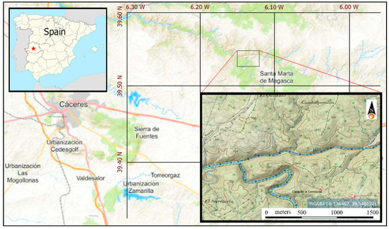
Figure 1.
Study area location. Source: authors’ own figure.
The area presents a topography of gentle forms, with slight variations because the current hydrographic network is firmly established in the peneplain. The most significant feature is the absence of any high relief due to the predominance of Precambrian materials with medium to low resistance and a long history of erosion. The small pilot basin is at the head of the Magasca river, a tributary of the Almonte, part of the network of the Tajo. It has an area of approximately 35.4 ha and includes the upper basin of the 813 m-long Guadalperalón stream, whose downstream limit is at the measuring station used to study the erosion and hydrological processes operating in these areas.
It can be considered a typical dehesa, with similar features to many others in the region in terms of topography, rock substratum, soil, vegetation and current and past uses, all of which can be extrapolated to other areas of Extremadura [19].
Following the Food and Agriculture Organization (FAO) nomenclature, the soil in the area is dystric cambisol, with significant slate outcrops. In slope areas it is degraded to leptosols. In most of the area, the soil is less than 30 cm thick, with deeper soils occurring at the bottom of the watercourses [20], on alluvial deposits.
In these conditions, the most rational land use from a conservation perspective is livestock grazing in combination with controlled cultivation. While this would maintain the balance of the structure and low potential of the area, tillage erosion increases with the number of tillage operations [21], and the lack of an alternative livelihood or opportunity to obtain maximum return in the short term may have led to intensive cropping or overgrazing of the land in the past.
3. Methodology
The procedure used to recreate the conditions of the deposits in the study area was based on sediment and geochronological studies and correlation with historic and documentary data. This is a qualitative study, based on the important role of sediments as recorders of history.
After the deposit areas in the basin had been identified and defined, the study was conducted by surveying small sediment columns throughout the available sections in the basin. The levels and structures appearing in the sequence were examined, measured and described. The initial premise was that the conditions occurring during the sedimentation process must be reflected in some way in the sediment sequence.
The laboratory work comprised textural analysis of the sediment samples from each level and radiocarbon dating of charcoal samples collected in these levels.
3.1. Sediment Study
The deposits accumulated throughout the watercourse areas occupy an area of around 18,800m2, representing approximately 5% of the total area of the basin [22], and are strongly incised by gullies. In the middle and lower section of the bed, where the incisions reach the substratum, sediment thickness can be measured directly. These areas provide the sections where the sediment profiles can be surveyed, because the entire sediment infill can be easily observed to describe the vertical and lateral variations it has experienced. In the upper section of the bed, the material observed is almost homogeneous and the sediment infill thickness is limited. Using geophysical methods and applying vertical electric soundings (VES) when the conditions of the deposit outcrop prevented the use of other methods, we were able to study the sediment sequence indirectly and correlate the levels detected in the gully areas [22].
The representation of the sediment profiles shows the type of material, the thickness of the deposit, and the recognisable sections or levels.
Seven columns were surveyed across an area of approximately 140 m, starting from the first profile (P1) 180 m upstream from the final part of the study area (location of the measuring station) and continuing downstream (Figure 2).
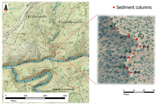
Figure 2.
Location map of column survey areas. Source: authors’ own work.
No distance was set between the profiles. The survey points were chosen in the field after identifying the sections where it would be easiest to measure and describe the levels, following the evolution of the sediment sequence. The final column (P7) was surveyed in the area next to the measuring station. The strong incision by gullies down to the rock bed permitted a complete survey of the sediment columns. Because of the continuity and quality of the sections in the study area, it was possible to establish correlations and identify variations observed in the deposit sequences. The levels identified in the deposit sequences were shown in a correlation diagram.
The sediment was texturally characterised by taking 12 samples of approximately 1 kg across the three levels differentiated in the surveyed columns. The textural analysis was performed at the Extremadura Regional Government Agricultural Laboratory. The content of coarse elements (expressed in %) was determined and the fine elements (sand, silt and clay) were used to define the texture class.
3.2. Sample Dating
Radiocarbon (or carbon-14) dating was used to date the sediment deposits. The material chosen was charcoal, because it was likely to occur in the deposits. Seven samples were collected, corresponding to the lower area, intermediate area (location of larger grain pebbles) and upper area in each profile to determine the age of each level. Dating by the conventional method was unsuccessful because of the small amount of carbon in the samples.
Accelerator mass spectrometry (AMS), which requires 10 mg carbon, was attempted. This method dated sample No. 1 (M-1), collected at the intermediate level of largest grain size (Figure 3) and identified as Ua-22602, but obtained no results for the other samples because they contained insufficient carbon.
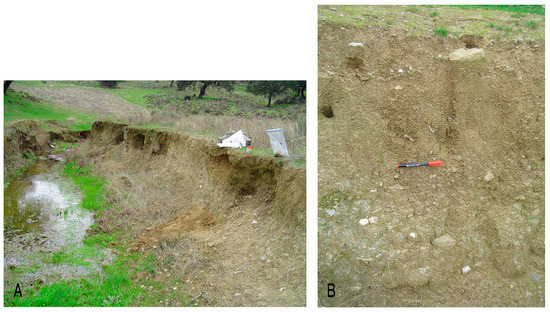
Figure 3.
Profile (A) and detail of level (B) where sample M-I was collected. Source: authors’ own work.
It was possible to date only one sample, collected at a depth of 50 cm, in the level with the elements of largest grain size detected in the sediment sequence. No results were obtained for the samples taken in the base and the upper part of the deposit. However, because the dated sample was found at a level that can be followed throughout much of the basin (guide level), it was possible to correlate the age obtained throughout this level and relate its occurrence to the processes that shaped its formation.
4. Results
The overall deposit sequence occurring in the study basin was determined through a complete survey of the sediment infill, by direct observation throughout each profile. The sediment profiles were indicated by drawing all the levels distinguished and the thickness of each one, as shown in the example of profile 1 (Figure 4).
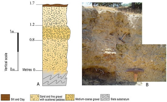
Figure 4.
Sediment profile 1 (A). Detail of the medium-coarse gravel level (B). Source: authors’ own work.
The data for the thickness of the levels differentiated in each profile are shown in Table 1. The lower thickness of the deposit closer to the measuring station can be seen. Level 2 is absent in the final profile surveyed.

Table 1.
Thickness of each level in the sediment profiles surveyed in the deposit areas.
With regard to texture, the predominant sediment in the overall sequence comprises around 62% coarse elements, mainly fine gravel. The texture of the fine fraction (sand, silt and clay) present in most of the samples analysed is sandy loam.
These results indicate that the infill materials in the watercourse areas are mainly sand and fine gravel with a silty matrix and scattered pebbles. A level of mainly medium-coarse gravel of 1.6 to 3.2 cm occurs in the mid-upper level of the deposit, and the sediment below and above this level has similar characteristics. The sequence was divided into three sections and their thickness was measured and described in each column surveyed. The upper level, named level 1, is located above the section with a predominance of medium gravel, named level 2. Level 3 is located in the lower part of the sequence, above the slate bed.
The upper part of level 1 culminates in a level of fine materials enriched with organic matter, the base of the herbaceous layer.
Contact between level 2 and the upper and lower levels is mainly irregular and at times poorly defined, but at some points it is well defined.
The correlation of the sediment columns is shown in the drawing in Figure 5, which shows the decreased thickness of the deposit further downstream. In the last profile surveyed it was not possible to distinguish the larger grain size level.
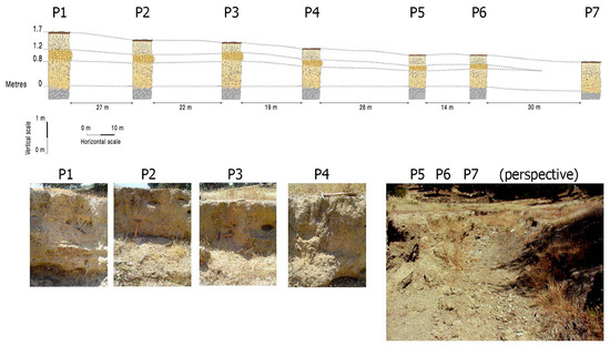
Figure 5.
Correlation of the sediment profiles surveyed in the study area. Different images are shown corresponding to points of the deposit area where the profiles have been carried out (P1-P7). Source: authors’ own work.
4.1. Overall Deposit Sequence
The sediments that make up the watercourse areas are terrigenous, with a predominance of sand and fine gravel in which facies of sand, clay and silt were identified. These materials tend to accumulate, creating a deposit with a thickness ranging from a few centimetres in some areas to 1.80 m in others. The silt and clay in the upper part of the profile are dark, with abundant edaphic features.
A level with a higher percentage of coarse elements with medium-coarse gravel particles is inserted in the mid-upper part of the profile. In situ measuring revealed sizes of 16 to 32 mm. These elements are mainly angular slate and quartz pebbles and scattered boulders. This level can be followed throughout most of the sediment infill of the bed, primarily in the lower section, where the greater thicknesses were recorded. The direct data from the survey of the columns indicated that it is located at a depth of 14 cm to 50 cm, occurring at lower depths in the thicker profiles. The minimum thickness measured in this level was 10 cm and the maximum was 50 cm, although the level was not identifiable when the deposit was less than 30–40 cm thick.
The sediment model that makes up these facies is associated with a context of slope erosion that resulted in the dense fraction and the sand. The soil corresponding to the fine fraction was displaced by rainwater.
Rainfall and runoff provide the initial energy necessary for the process of dislodging and transporting soil particles, and the topographical features determine the energy of the water current for transporting the particles. Similarly, soil composition and structure (particle size, cohesion, etc.) affect the capacity of the rainfall and runoff energy to carry soil particles. Therefore, human activity, through cropping, is determinant in altering soil erosion susceptibility. The flow erodibility coefficient depends on the type of soil, and changes in this parameter produce considerable changes in sediment production [23].
The sediment of the sequence studied represents the material corresponding to soil erosion in the area where the basin is located; i.e., soil of the Cáceres peneplain occurring on slate, with shallow depths of 25 to 50 cm. In the slope erosion process, a greater transport capacity was registered for rainfall, seen in the level of larger grain pebbles identified in the sequence. This could be due to the higher amount of stones in the soil profile caused by more intense tillage than in an earlier period. Soil redistribution by mechanical displacement during tillage has been recognised as a process of intense soil degradation (mechanical erosion, also known as tillage erosion). Empirical models describing the mechanisms of mechanical soil redistribution have shown that most agricultural tools used in very diverse farming conditions generate very high rates of soil remobilisation [24,25,26,27,28,29].
The deposit analysed can be interpreted as the effect of soil redistribution caused by past agricultural practices, entailing a modification or interaction in the water-erosion processes that altered the normal rhythm of the deposit of the sediment sequence in the study area, displacing larger grain size material.
4.2. Radiocarbon Dating Results
The results of dating sample M-1, identified as Ua-22606, provided a conventional radiocarbon age of 180 ± 30 BP, corresponding to a calibrated result (2 sigma, 95% probability) of Cal 1650 to 1950. The calibration graph is shown in Figure 6.
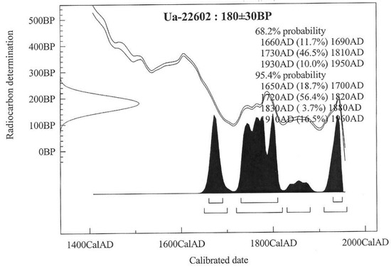
Figure 6.
Calibration curve for sample Ua-22606.
This calibrated age range indicates that the materials deposited above the level where the sample is located are later than 1650 and have a 56% probability of being later than 1720–1820.
Because the results were obtained from the sample taken at the bottom of the level of coarse pebbles (indicative of a change in the conditions of the deposit), a connection can be made to events in the environment that are documented, occurred over time, and could have influenced the variation in the conditions of the deposit. Although carbon 14 does not allow a specific date to be assigned to an occurrence, it helps to identify a possible period for investigation.
If the dated sample had been taken at a level with continuity in the rhythm, it would be possible only to indicate the interval in which the deposit might have occurred. In a deposit where the sequence shows no alteration or variation, it is difficult to determine the time frame if there is no known external episode that it can be referenced to. Unfortunately, no other examples were found for dating to determine the age of the sediment at the lowest or the uppermost part of the deposit and extend the chronology of all the materials. However, dating provided an important reference to study the recent evolution of these spaces.
5. Discussion
The sediment study shows that the predominant sediments in the overall sequence are sand and fine gravel with a silty matrix, with the insertion of a level with a high percentage of coarse elements (close to 80%) of medium-sized gravel. After this level was measured in each column, it was shown to have a variable thickness (maximum 50 cm, minimum 14 cm). It is located at a depth of 50 to 20 cm, decreasing in thickness and depth as the deposit becomes less thick, and is not identifiable when the profile has a limited thickness. Therefore, it is not a lens without lateral continuity, because it is distinguishable and continues in each column surveyed. Interpretation of vertical electric soundings [22] also shows these variations in deposit grain size at other parts of the basin where the sequence was not observed directly.
At the level with the largest grain size identified, remains of carbonised organic matter collected at a depth of 0.5 m show a conventional radiocarbon age of 180 ± 30 BP. This age corresponds to a calibrated result (2 sigma, 95% probability) Cal of 1650–1950, with a higher probability in the interval 1720–1820. It is therefore likely that the higher grain size level is later than this time interval.
The sediment model that makes up these facies is associated with a context of slope water erosion that caused the infill in the watercourse areas. The infill is terrigenous, with a predominance of sand and fine gravel in which the level of coarser pebbles must be associated with a variation in the normal rhythm of sedimentation, resulting in displacement of larger grain elements. This greater displacement could be associated with agricultural tasks, because tillage has considerable impact on water erosion processes and greatly increases soil particle mobilisation [29].
Studies of gully erosion in an experimental basin (Parapuños) near the study area reported a similar level of material of fluvio-colluvial origin, with a percentage of coarse fragments inserted in the infill, indicating a variation in the soil erodibility coefficient comparable to that of the study area. After field observation followed by grain size analysis [30] reported a level of coarse material (>2 mm) in all profiles. This layer was located at different depths of each profile and at least 40% of the sample material was coarse. However, in most of the profiles, the coarse material it contained was more than 70% of the total sample. This level mainly comprised fragments with a diameter of 2 to 6 cm, but in some cases as much as 20 cm.
Obtaining similar results in areas close to the study basin was a very significant finding, because they have common source areas in which the same model of sediment production must have occurred.
After analysing all the data, it was necessary to return to the study objective of assessing the deposit conditions in the basin to determine whether the sedimentation process was natural or human-accelerated.
Using the sedimentation and chronological results obtained, it was possible to determine the historical events that might have influenced the erosion and deposit processes in the basin. The data for the land-use changes in the dehesa in the estimated period were studied, focusing on any modifications caused by human activity. The documentary sources for the estimated period do not refer to any exceptional rainfall events associated with crises or epidemics that could have caused anomalous transportation of materials or high erosion rates.
In the late 18th and early 19th centuries, historical events led to changes in land use in the region. This period was the culmination of a policy that began in 1770 to reallocate land for crops. A Royal Decree of 1793 declared that extensive tracts of land previously available for transhumance were to be used for grazing and cropping [31].
The land reform, initiated by Godoy, was preceded by strong complaints about practitioners of transhumance, who were blamed for the lack of cropland, the decline of agriculture and the debilitation of the region [32].
Pastureland that kept the dehesa in ecological balance was converted to cropland, in most cases resulting in soil with a limited profile, overuse and the consequent loss of structure and texture, making the land more vulnerable to erosion. The rock fragments characteristic of the soil were more exposed to displacement processes after the land was tilled [21,28]. Soil disintegration and redistribution due to agricultural tasks have been recognised as a process of intense soil degradation [29,33]. The accumulated results of this process are evidenced in recent deposits in the watercourse areas.
During this phase of extensive, widespread ploughing, a considerable amount of materials would have reached the watercourses and gradually filled in their beds. However, the infill would have had little stability, because the beds were exposed to active processes from the concentration of surface runoff [21] that created deep gullies along the watercourses.
To a certain extent, the introduction of the agricultural reform, followed by the decline of long-distance transhumance, marked a turning point in land use in the region. The reform changed agriculture by increasing the area under crops after the granting of wasteland and uncropped land, although some of the land was cultivated only for a short time or left untouched because of its poor quality or the high costs of farming it.
It is likely that the dehesa where the Guadalperalón and Parapuños basins are located was no exception to these land-use changes, which must have had a repercussion or impact in the short to medium term. The results of analysing the sediments corresponding to this historical period in a typical dehesa such as the pilot hydrographic basin studied should be considered in this light.
6. Conclusions
Using the data provided in this study, we can assess the possible contribution of tillage erosion in the past to the evolution of the landscape. Studies of this kind, which are lacking for Extremadura, can be used to reconstruct many aspects of past actions in these spaces with regard to their hydrogeomorphological dynamics, and have the added value of completing the findings of other studies, thus helping to increase knowledge about recent processes in these areas of high regional significance.
The sediment study of the watercourse areas indicates an alteration in the sediment sequence (level of coarse elements of larger grain size) attributable to changes in the deposit conditions. In this qualitative study, the materials in the level where the grain size changed were dated, providing an age range in which there were no data about the chronology. This is important for identifying the historical context in which the deposit occurred; i.e., the late 18th century.
The continuity of this level of coarser pebbles detected in the deposit sequence (continuing through a large part of the bed) and in other watercourses nearby indicates that the origin of the change was a process associated with the entire source area rather than an isolated process. It must have continued over a sufficient period to make it significant in the overall sequence, interpreted as slope erosion. After the change in grain size occurred, there was a further period of stabilisation.
Although it is difficult to assess the scope of the historical change in land use and determine whether it can be considered an environmental crisis, the almost constant appearance of this level of larger grain size materials in the infill sequence of a nearby experimental basin with similar environmental features [30] supports the idea of a repercussion on the environment caused by historic events that occurred during the period studied. However, more detailed studies of the agricultural history are needed to verify the agricultural transformations in the study areas.
With regard to the limitations of the study, the pilot basin was chosen as the experimental area despite its limited scope because its uses and physical and geological features make it a typical dehesa. It is also located in an extensively studied seminatural ecosystem that forms part of the drainage network degrading the Cáceres peneplain. Because of this, it can be considered representative of the evolution of the area it belongs to and optimum for possible data extrapolation.
It should be noted that although it was possible to date only one sample from the sediment level where the alteration in the rhythm of the sequence occurred, the dating can be considered valid because the sample is located at an extensive guide level that continues along much of the deposit. The carbon dating indicates the interval from which sedimentation of this level occurred and identifies the period, allowing the deposition to be related to documented historical events. Although the exact period is not defined, the range is important because it provides sedimentary evidence to investigate the cause of the larger grain-size level. If no alteration in the rhythm of deposition had been detected in the sequence, it would not have been possible to relate the deposit of the material to external processes that took place in the area during the period when the deposit occurred.
Despite these limitations, the sedimentary evidence and radiocarbon dating revealed increased erosion of coarse material in the study basin that could have undergone the same historical transformations occurring in similar areas. This concurs with the historical sources cited, probably in the late 18th century and early 19th century, due to human intervention in the region after changes in land use. The results shed light on the environmental implications of past human activity, such as tillage operations, and have future applications for conserving this dominant ecosystem in a region of high economic and environmental importance, in which humans play a significant role in its regeneration and conservation.
Author Contributions
Formal analysis, M.T.T.R., A.D.Á. and L.G.-M.; Funding acquisition, L.G.-M.; Investigation, M.T.T.R., A.D.Á. and L.G.-M.; Methodology, M.T.T.R.; Project Administration, M.T.T.R.; Supervision, M.T.T.R., A.D.Á. and L.G.-M.; Writing—original draft, M.T.T.R.; Writing—review and editing, M.T.T.R., A.D.Á. and L.G.-M.
Funding
This article has been funded by the Government of Extremadura (Ref. GR18176).
Acknowledgments
Publication of this article has been possible thanks to the funding of the Government of Extremadura and the European Regional Development Fund (ERDF), reference GR18176, granted to the research team INNOVA (Diseño, Sostenibilidad y Valor Añadido) of the University of Extremadura.
Conflicts of Interest
The authors declare no conflict of interest
References
- Brown, A.; Toms, P.; Carey, C.; Rhodes, E. Geomorphology of the Anthropocene: Time-transgressive discontinuities of human-induced alluviation. Anthropocene 2013, 1, 3–13. [Google Scholar] [CrossRef]
- Syvitski, J.P.M.; Kettner, A. Sediment flux and the Anthropocene. Philos. Trans. R. Soc. Lond. Math. Phys. Eng. Sci. 2011, 369, e975. [Google Scholar] [CrossRef] [PubMed]
- Santisteban, J.I.; Mediavilla, R.; Gil García, M.J.; Domínguez Castro, F.; Ruiz Zapata, M.B. La historia a través de los sedimentos: Cambios climaticos y de uso del suelo en el registro reciente de un humedal mediterráneo (Las Tablas de Daimiel, Ciudad Real). Bol. Geol. Min. 2009, 120, 497–508. [Google Scholar]
- Arnaud, F.; Poulenard, J.; Giguet-Covex, C.; Wilhelm, B.; Révillon, S.; Jenny, J.P.; Revel, M.; Enters, D.; Bajard, M.; Fouinat, L.; et al. Erosion under climate and human pressures: An alpine lake sediment perspective. Quat. Sci. Rev. 2016, 152, 1–18. [Google Scholar] [CrossRef]
- Dearing, J.A.; Jones, R.T. Coupling temporal and spatial dimensions of global sediment flux through lake and marine sediment records. Glob. Planet. Chang. 2003, 39, 147–168. [Google Scholar] [CrossRef]
- Plieninger, T.; Schair, H. Elementos Estructurales del Paisaje Adehesado Tradicional en Monroy y Torrejón el Rubio (Cáceres) y su Importancia Para la Conservación de la Naturaleza y el Desarrollo Rural; Revista de Estudios Extremeños I, Departamento de Publicaciones, Diputación de Badajoz: Badajoz, Spain, 2006. [Google Scholar]
- Gómez Amelia, D.; Schnabel, S. Procesos Sedimentológicos e Hidrogeológicos en Una Pequeña Cuenca Bajo Explotación de Dehesa en Extremadura; López Bermúdez, F., Conesa García, C., Romero Díaz, M.A., Eds.; II Reunión Nacional de Geomorfología, Sociedad Española de Geomorfología: Murcia, Spain, 1992; pp. 55–63. [Google Scholar]
- Schnabel, S. Soil Erosion and Runoff Production in a Smallwatershed Under Silvo-Pastoral Landuse (Dehesas) in Extremadura, Spain; Geoforma Ediciones: Logroño, Spain, 1997. [Google Scholar]
- Ceballos Barbancho, A. Procesos Hidrológicos en Una Pequeña Cuenca Hidrográfica Bajo Explotación de Dehesa en Extremadura; Servicio de Publicaciones; Dpto de Geografía y O.T. Facultad de Filosofía y Letras Universidad de Extremadura: Badajoz, Spain, 1999. [Google Scholar]
- Mateos Rodríguez, A.B. Interceptación de la Lluvia por la Encina en Espacios Adehesados. Ph.D. Thesis, Universidad de Extremadura, Cáceres, Spain, 2003. [Google Scholar]
- Schnabel, S.; Ceballos Barbancho, A.; Gómez Gutiérrez, Á. Erosión Hídrica en la Dehesa Extremeña. En: Aportaciones a la Geografía Física de Extremadura con Especial Referencia a las Dehesas; Schnabel, S., Lavado Contador, J.F., Gómez Gutiérrez, Á., García Marín, R., Eds.; Fundicotex: Cáceres, Spain, 2010; pp. 153–185. [Google Scholar]
- De Tena Rey, M.T. Caracterización y Análisis de los Depósitos Sedimentarios de Áreas de Vaguada en Dehesas de Extremadura. Arroyo de Gadalperalón (Cáceres); Universidad de Extremadura: Badajoz, Spain, 2008. [Google Scholar]
- Puerto, A. La dehesa. Investig. Cienc. 1997, 253, 66–73. [Google Scholar]
- Pulido, M.; Schnabel, S.; Contador, J.F.L.; Lozano-Parra, J.; Gómez-Gutiérrez, Á.; Brevik, E.C.; Cerdà, A. Reduction of the Frequency of Herbaceous Roots as an Effect of Soil Compaction Induced by Heavy Grazing in Rangelands of SW Spain. Catena 2017, 158, 381–389. [Google Scholar] [CrossRef]
- García-Ruiz, J.M.; Berguería, S.; Lana-Renault, N.; Nadal-Romero, E.; Cerdà, A. Ongoing and emergingquestions in water erosion studies. Land Degrad. Develop. 2017, 28, 5–21. [Google Scholar] [CrossRef]
- Novara, A.; Stallone, G.; Cerdà, A.; Gristina, L. The Effect of Shallow Tillage on Soil Erosion in a Semi-Arid Vineyard. Agronomy 2019, 9, 257. [Google Scholar] [CrossRef]
- Cerdà, A.; Rodrigo-Comino, J.; Novara, A.; Brevik, E.C.; Vaezi, A.R.; Pulido, M.; Keesstra, S.D. Longterm impact of rainfed agricultural land abandonment on soil erosion in the Western Mediterranean basin. Prog. Phys. Geogr. Earth Environ. 2018, 42, 202–219. [Google Scholar] [CrossRef]
- De Tena Rey, M.T. Penillanura Trujillanos-Cacereña; Muñoz Barco, P., Martínez Flores, E., Eds.; Patrimonio Geológico de Extremadura; Junta de Extremadura; Conserjería de Industria, Energía y Medio Ambiente: Mérida, España, 2010; p. 478. [Google Scholar]
- De Tena Rey, M.T.; Gutiérrez Gallego, J.A.; Martín Nogales, E. Aplicación de un SIG a la Cartografía Regional de Áreas con los Parámetros Físicos-Geológicos y Usos de Una Cuenca Experimental (Provincia de Cáceres). Mapping 2007, 115, 64–68. [Google Scholar]
- Gómez Amelia, D.; Schnabel, S. Hidrología y Erosión en Ambientes de Pastoreo Extensivo; Lasanta, T., García Ruiz, J.M., Eds.; Erosión y Recuperación de Tierras en Áreas Marginales, Instituto de Estudios Riojanos y Sociedad Española de Geomorfología: Logroño, España, 1996; pp. 137–154. [Google Scholar]
- De Alba, S.; Lindstrom, M.; Schumacher, T.E.; Malo, D.D. Soil landscape evolution due to soil redistribution by tillage: A new conceptual model of soil catena evolution in agricultural landscape. Catena 2004, 58, 77–100. [Google Scholar] [CrossRef]
- García de Prado, J.; De Tena, M.T.; Pro, C. Estudio Topográfico y prospección geoeléctrica de las áreas de depósito de una pequeña cuenca hidrográfica en la provincia de Cáceres (España). Mapping 2007, 115, 45–49. [Google Scholar]
- Zambrano Nájera, J. Estimación de la Producción y Transporte de Sedimentos en Cuencas Urbanas Pequeñas a Escala de Evento Mediante un Modelo de Base Física Basado en SIG. Ph.D. Thesis, Universidad Politécnica de Cataluña, Barcelona, Spain, 2015. [Google Scholar]
- De Alba, S.; Lacasta, C.; Benito, G.; Perez Gonzalez, A. Influence of Soil Management on Water Erosion in a Mediterranean Semiarid Environment in Central Spain; Garcia Torres, L., Benitez, J., Martinez Vilela, A., Eds.; Food and Agriculture Organization-European Conservation Agriculture Federation: Brussels, Belgium, 2001; pp. 173–177. [Google Scholar]
- De Alba, S.; Alcázar, M.; Cermeño, F.I.; Barbero, F. Erosión y Manejo del Suelo. Importancia del Laboreo Ante los Procesos Erosivos Naturales y Antrópicos. En: Agricultura Ecológica en Secano: Soluciones Sostenibles en Ambientes Mediterráneos; Ministerio De Agricultura, Alimentación y Medio Ambiente: Madrid, Spain, 2011; pp. 13–38. [Google Scholar]
- Lindstrom, M.J.; Nelson, W.W.; Schumacher, T.E. Quantifying tillage erosion rates due to moldboard plowing. Soil Tillage Res. 1992, 24, 243–255. [Google Scholar] [CrossRef]
- Govers, G.; Lobb, D.A.; Quine, T.A. Tillage erosion and translocation: Emergence of a new paradigm in soil erosion research. Soil Tillage Res. 1999, 51, 167–174. [Google Scholar]
- Torri, D.; Borselli, L.; Calzonari, C.; Yáñez, M.; Salvador-Sanchis, M.P. Soil Erosion, Land Use, Soil Quality and Soil Functions: Effects of Erosion; Rubio, J.L., Morgan, R.P.C., Asins, S., Andreu, V., Eds.; Geoforma Ediciones: Logroño, Spain, 2002; pp. 131–148. [Google Scholar]
- De Alba, S. Erosión y Redistribución Mecánica del Suelo (Tillage Erosion): Transformación de los Paisajes Agrícolas; Cerdá, A., Ed.; Erosión y Degradación del suelo agrícola en España, Cátedra de Divulgación Científica, Universidad de Valencia: Valencia, Spain, 2008; pp. 149–182. [Google Scholar]
- Gómez Gutierrez, A. Estudio de la Erosión en Cárcavas en Áreas con Aprovechamiento Silvopatoril. Ph.D. Thesis, Universidad de Extremadura, Cáceres, Spain, 2009. [Google Scholar]
- Rodríguez Grajera, A. Una norma preliberal. El Real Decreto 28 de abril de 1793 y sus repercusiones en Extremadura. Josep Fontana. Historia I Projecte Social. Reconeixement a una trajectoria. Crit. Barc. 2004, 2, 212–228. [Google Scholar]
- Melón Jiménez, M.A.; Rodriguez Grajera, A. Extremadura; La Historia: Badajoz, Spain, 1997. [Google Scholar]
- Wysocka-Czubaszek, A.; Czubaszek, R. Tillage erosion: The principles, controlling factors and main implications for future research. J. Ecol. Eng. 2014, 15, 150–159. [Google Scholar] [CrossRef]
© 2019 by the authors. Licensee MDPI, Basel, Switzerland. This article is an open access article distributed under the terms and conditions of the Creative Commons Attribution (CC BY) license (http://creativecommons.org/licenses/by/4.0/).