1. Introduction
Forest roads are the primary access infrastructure for silvicultural operations, timber harvesting, forest protection, wildfire suppression, disaster response and recreation, and they are among the most consequential engineering interventions routinely undertaken in forest landscapes [
1]. Their extent and spatial arrangement govern which parts of a forest estate can be managed at all, and road density and accessibility metrics are accordingly used worldwide as basic indicators of forest management capacity [
2]. Because roads intercept and redirect surface and subsurface flow, generate and deliver sediment, fragment habitat and extend human access into forest interiors [
3,
4,
5], road management must reconcile operational accessibility with environmental protection and with the lifecycle cost of the asset.
Forest roads are also long-lived assets whose condition changes continuously under traffic, weather and deferred maintenance. Condition-based management of forest roads has become an active field in its own right, ranging from pavement condition indices developed specifically for forest roads [
6] to automated detection of surface deterioration from mobile laser scanning [
7]. Parallel work on automated road extraction and inventory construction from remotely sensed data [
8,
9] reflects a broader shift toward road records that are spatially explicit and machine-readable rather than descriptive.
Two operational demands place particularly sharp requirements on what a road record must convey. The first is emergency access: distance to a usable road is among the strongest predictors of whether a wildfire can be engaged at all, which makes the road network a component of suppression capability rather than merely a means of reaching a fire [
10,
11]. The second is timber transport, which accounts for the overwhelming majority of long-distance roundwood movement and is constrained by vehicle configuration, permissible gross weight and structure capacity rather than by road width alone [
12]; upgrading road standards changes which vehicles may be used and therefore the delivered value of the timber [
13]. In both cases the decisive question is not what a road is called but what it can currently carry.
A forest-road classification system is consequently not merely a terminology framework. It determines how individual roads are planned, designed, recorded, maintained and communicated to users [
1,
2]. A classification may describe the purpose of a road, its position within a network, the vehicle it is designed to accommodate, its geometric and structural capability, its seasonal accessibility or the maintenance condition currently provided [
12,
13]. These characteristics are related but conceptually distinct, and they answer three different questions. A functional classification explains why a road exists. An engineering classification indicates what vehicle, load and performance requirements the road is intended to satisfy. A maintenance or service classification describes the condition and accessibility actually being provided at present. Where these dimensions are compressed into a single road designation, a user cannot infer the capability or the current state of a route from its name.
This three-way separation is not novel in road administration generally. In mature road agencies, functional classification, structural or design characteristics and current condition are maintained as separate attribute families rather than collapsed into a single composite grade. National inventory specifications assign each its own data items: the Highway Performance Monitoring System records functional system separately from lane and layer-thickness items and separately again from roughness, rutting and cracking [
14], and the Specifications for the National Bridge Inventory likewise separate functional classification, load-rating items and condition ratings [
15]. National codes of practice treat network hierarchy, asset inventory and condition survey as distinct requirements [
16]. The distinction mirrors the long-standing separation in pavement engineering between structural capacity and in-service serviceability, introduced precisely because design systems did not represent the level of performance actually being delivered [
17] and still treated as two properties that must be assessed in parallel [
18]. What has not been done is to use that separation as a comparative lens on forest-road classification, where the three families are routinely fused.
Forest-road classification is also not aligned internationally. The terms class, grade, level, passability and accessibility carry different and sometimes incompatible meanings between jurisdictions, and no common analytical basis exists on which national systems can be placed side by side. This matters beyond terminology, because road attributes are increasingly expected to feed national databases, transport planning systems and navigation services, which requires the underlying categories to be explicit about what they encode [
19].
Previous studies provide an important foundation. Rhee et al. [
20] compared Korean and United States forest-road policies with respect to road density, expenditure, construction, maintenance and decommissioning. Rodrigues et al. [
21] examined the use of classification systems in forest-road research and found that classification had not been sufficiently integrated into road-planning studies. Pohle and Jaeger [
22] compared forest-road guidelines from multiple regions, concentrating on drainage, water management and climate adaptation. A further body of work addresses the spatial optimization of road networks and the assessment of forest accessibility using geographic information systems [
23]. Collectively these studies establish that classification and technical guidance matter, and that road network structure can be analyzed rigorously.
A specific gap nevertheless remains. The purpose–capability–condition separation that general road administration keeps explicit has not been applied as a comparative instrument to forest-road classification systems; no study has tested whether jurisdictions distinguish these three as separate attributes or fuse them into a single designation, and none has examined what follows operationally when they are not separated. Existing comparative work has treated either policy aggregates [
20], the academic use of classification [
21], or a single technical theme across guidelines [
22], rather than the internal architecture of the classifications themselves.
This study therefore asks whether forest-road classification systems separate the questions of purpose, capability and condition, and what follows operationally when they do not. Three objectives were pursued: to specify an explicit analytical framework for describing the architecture of forest-road classification systems; to apply that framework to six purposively selected jurisdictions using operative legal and technical instruments; and to evaluate what the separation of management dimensions delivers, demonstrating the application of the framework in one jurisdiction. The design is deductive: the framework is specified in advance, in
Section 2.3, and is then used as a coding instrument. It is not inferred from the cases, and the analysis reported here therefore tests how the six systems stand against the framework rather than establishing that three axes are the only possible decomposition. The Republic of Korea is used for the demonstration because it is currently in legislative transition, having enacted a dedicated forest-road statute that enters into force in 2027 [
24], which makes the practical consequences unusually concrete.
2. Materials and Methods
This section sets out the study design and case selection, the protocol by which documents were identified and appraised, and the analytical framework and coding procedure applied to them.
2.1. Study Design and Selection of Jurisdictions
This study is a comparative institutional analysis of operative forest-road legislation, regulation and technical standards. The unit of analysis is the institutional forest-road management framework of a jurisdiction, not an individual road or a body of literature. Official legal and technical instruments were treated as the primary evidence because road classifications and mandatory engineering requirements are defined in legislation, regulations, government directives, engineering manuals and nationally recognized operational guidelines rather than in the peer-reviewed literature. Peer-reviewed studies were used to establish the academic and environmental context and to situate the findings, and not as evidence of what a jurisdiction requires.
Six jurisdictions were selected purposively to maximize variation in classification logic rather than to achieve statistical or geographic representativeness: Japan, the United States, British Columbia in Canada, New Zealand, Sweden and the Republic of Korea. The selection rationale and the principal documentary sources for each are given in
Table 1. Because the cases were chosen for contrast, the analysis does not claim that these six systems represent all forest-road frameworks worldwide.
2.2. Document Identification, Selection and Appraisal
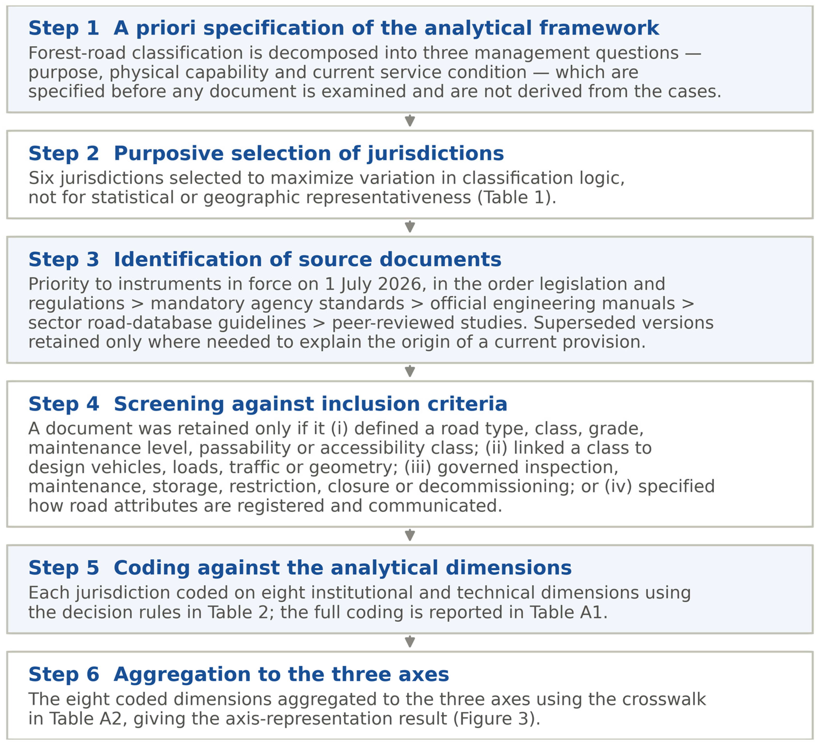
The review process is summarized in
Figure 1. Documents were identified from national legislation databases, the official publication series of the responsible forest agencies and the recognized sector bodies that maintain forest-road records. Priority was given to instruments in force on 1 July 2026; superseded versions were retained only where they were necessary to explain the origin or development of a current provision. Supporting peer-reviewed literature was searched in Scopus, Web of Science and Google Scholar for the period 1998–2026 using combinations of “forest road” with “classification”, “class”, “grade”, “maintenance level”, “accessibility”, “passability”, “design vehicle”, “road inventory” and “decommissioning”.
A document was retained only if it satisfied at least one of four inclusion criteria: it defined a forest-road type, class, grade, maintenance level, accessibility class or passability class; it connected such a category with design vehicles, loads, traffic or geometric criteria; it governed road inspection, maintenance, storage, restriction, closure or decommissioning; or it specified how road attributes are registered and communicated. Documents were excluded where they addressed public highways rather than forest roads, where they were internal company standards not publicly issued, where they had been superseded and were not needed to explain a current provision, or where they contained no classificatory or capability content. Where several documents addressed the same subject, the most recent operative version was used.
Retained documents were interpreted according to a hierarchy of institutional authority: legislation and regulations, then mandatory government or agency standards, then official engineering and management manuals, then recognized forestry-sector or road-database guidelines, and finally peer-reviewed studies. This hierarchy was applied as an interpretive principle for resolving apparent conflicts between sources, not as a formal quality-scoring system. The instruments analyzed therefore differ in legal status: in some jurisdictions a classification is fixed in binding legislation, in others in a mandatory agency standard, and in others again in a guideline issued by a sector body. The hierarchy is what makes that difference explicit rather than concealing it, and the level at which each jurisdiction is evidenced is stated in
Table 1 and carried through to
Table A1. It was not possible to reach the same level of the hierarchy in every jurisdiction, and the consequences of that asymmetry are addressed in
Section 4.
2.3. The Three-Axis Framework and Coding Procedure
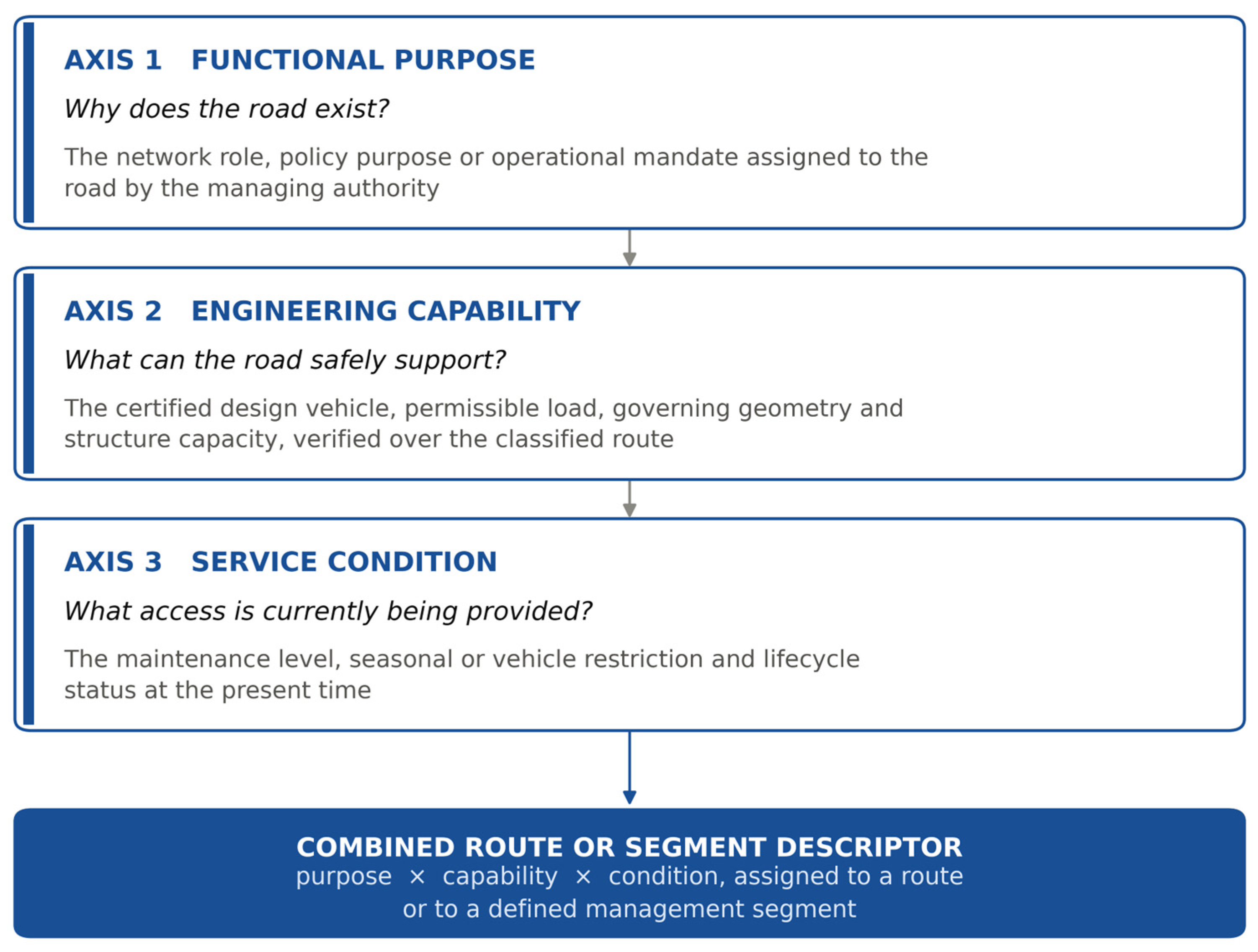
The analytical framework applied here is specified in advance and is shown in
Figure 2 and defined in
Table 2. It decomposes a forest-road classification into three axes that answer different questions. Functional purpose is an administrative determination made by the managing authority and states why the road exists; it is not recoverable from physical measurement. Engineering capability is a certified physical property and states what the road can safely support; it is established by design and verification and changes only when the road is altered or re-assessed. Service condition is a current management state and states what access is actually being provided; it changes with maintenance, damage, season and administrative restriction, and may fall below the certified capability at any time. Three notions that are easily conflated belong on this third axis and should be distinguished. The current condition of a road is its observed physical state. The maintenance level is the service the managing authority is presently undertaking to provide, which is an administrative commitment rather than an observation. The target maintenance level is the service the authority intends the road to provide under a future management objective. The third axis carries the second of these—the service currently being provided—because that is the value a user must be able to read off the record; observed condition is the evidence on which it is set, and the target level belongs with the management plan rather than with the road as it now stands. The United States’ system, which records an operational maintenance level alongside an objective maintenance level, keeps precisely this distinction and is treated accordingly in the coding. The three are not alternatives and cannot substitute for one another, and a value on one axis does not determine a value on either of the others.
Two boundaries of the framework should be stated before it is applied. The first concerns what it covers. The framework describes what a road record states about the road itself. Environmental sensitivity—proximity to watercourses, slope stability, sediment delivery and habitat connectivity—is a property of the road’s setting rather than of the road, is regulated through separate instruments in all six jurisdictions and would form a fourth dimension resting on a different logical footing, since it constrains what may be done to a road rather than describing what the road is or currently provides. Its exclusion is a decision about scope and not an oversight, and
Section 4 returns to what follows from it.
The second boundary lies between the second and third axes, and needs a rule because deterioration eventually crosses it. A bridge designed for a given load but corroded below it has plainly changed, but it is not obvious on which axis. The convention adopted here is that capability changes only through re-certification: deterioration alters condition, and continues to do so, until the road or structure is re-assessed, at which point it may alter capability. The boundary is therefore the administrative act of re-assessment rather than the severity of the defect. This is what allows a damaged route to be recorded as closed while retaining the grade to which it is to be restored, and it is why the two axes remain distinct rather than collapsing into a single measure of current performance.
Because the second axis is the one most easily read as a proxy for width, what determines a grade should be stated with the framework rather than left to the application. Four groups of variables govern it: the design vehicle, expressed as its dimensions, turning path, gross weight and axle configuration; the load-bearing elements of the route, principally bridge and major-culvert capacity together with surface and subgrade performance; the governing geometry, comprising effective width and turnout spacing, minimum curve radius and curve widening, sustained and exceptional gradient, design speed and stopping sight distance, and vertical and lateral clearance; and the provision made for operation and escape, that is drainage and erosion control, turnarounds and emergency refuges. Two consequences follow that matter for how the axis is read. First, the design vehicle of record is not necessarily the vehicle for which the road was originally built. A grade states the vehicle the route has been verified to accommodate, and a route may later be verified for a different configuration—a shorter tractor unit, a different trailer, a reduced gross weight—by re-assessment of the governing elements rather than by reconstruction. Where that verification is carried out the certified grade changes; where a different vehicle is admitted for a single movement without it, the permission is an entry on the third axis, and the grade is untouched. Second, traffic volume is an indicator of the performance likely to be required and not a defining criterion of a grade. A road carrying few vehicles a year may still require the highest grade if those vehicles are loaded timber-transport combinations, and a road carrying many light vehicles may require the lowest. Where a jurisdiction ties its classes to traffic thresholds, as New Zealand does, the threshold serves as a proxy for the governing vehicle rather than as the property being classified.
A short case makes the boundary between the second and third axes’ concrete. A route certified to a given grade carries a bridge whose permissible load is reduced during the spring thaw. The certified grade is unchanged, because nothing has been re-assessed and nothing has been physically altered; what changes is the condition record, which drops one level for the affected segment, carries the reduced permissible load and the season over which it applies, and names the bridge as the governing element. When the thaw passes the entry is closed and the segment returns to its former level without any act of reclassification. Had the bridge instead been found permanently deficient, the route would stay at the lower condition level until re-assessment, and re-assessment—not the inspection finding—would be what lowers the certified grade. Permanent capability and temporary accessibility are therefore separated by an administrative act and not by the severity of the defect.
Each jurisdiction was read against eight institutional and technical dimensions, set out with their coding rules in
Table 3. The dimensions were specified before the documents were coded and follow from the three axes. The comparison deliberately emphasized the institutional meaning of each category rather than assuming that the terms class, grade, level, passability and accessibility are interchangeable between jurisdictions or between languages. A numbered engineering grade may describe width and design vehicle, whereas a maintenance level describes the service currently provided; vehicle passability is likewise not the same as seasonal accessibility.
Each dimension was coded on three levels. A dimension was coded as recorded independently (●) where the jurisdiction assigns it as a separate attribute of the road that can vary without changing any other attribute. It was coded as embedded (◐) where the information exists but only as a property of another assigned category, so that it cannot be varied or queried on its own. It was coded as not represented (○) where no provision in the instruments examined assigns the attribute to a road, whether because the matter is handled at project level without being recorded as a road attribute or because it is not addressed at all. A code of ○ is therefore a statement about the instruments listed in
Table 1 and not an exhaustive negative about the jurisdiction; the cells most sensitive to a wider document set are identified in
Section 4.
The eight dimension codes were then aggregated to the three axes by the rule set out in
Table A2: an axis is coded ● where at least one constituent dimension is assigned as an attribute of the road independently of the other axes, ◐ where the constituent dimensions are present only as properties of another assigned category and ○ where no constituent dimension is recorded. The full eight-dimension coding, with the governing instrument for every cell, is reported in
Table A1. The documents were selected and coded by a single author; publishing the decision rules, the complete coding and the governing instrument for each cell is intended to make the procedure auditable, but it is not a substitute for independent coding, and this limitation is stated in
Section 4.
3. Results
The comparative architecture of the six systems is described first, the coded representation of the three axes is reported second, and the resolution at which the axes can legitimately be assigned is established third.
3.1. Classification Architecture of the Six Jurisdictions
Japan operates a layered system in which several attributes are applied together. Forest roads are divided into motor roads, light-vehicle roads and monorails; motor roads are further divided into Type 1 and Type 2 according to design vehicle, and into Grades 1 to 3 according to carriageway width [
25]. Type 1 motor roads use a semi-trailer as the design vehicle, Type 2 Grade 1 and Grade 2 roads use a standard motor vehicle, and Type 2 Grade 3 roads use a small vehicle. Grade 1 roads have a carriageway width of at least 4.0 m, Grade 2 roads 3.0 m and Grade 3 roads 2.0 m. The grade is in turn linked with design speed, curve radius, gradient, sight distance, shoulder width, structure load, passing places and turning facilities [
26,
27], and trunk, branch and sub-branch roles are distinguished when design requirements are applied. Japan also assesses condition, but at a different resolution. Forest-road bridges of 4 m or more, tunnels and shelter structures are inspected on a five-year cycle and given a four-tier soundness diagnosis running from sound, through preventive-maintenance and early-measure stages, to an emergency-measure stage, and the results must be recorded and accumulated [
28,
29]. That diagnosis attaches to the individual structure and enters the inspection record and the facility-level management plan. The forest-road ledger required by the Forest Road Regulations records road type, structure and asset classification, but no condition attribute [
25]. Condition is therefore assessed and recorded in Japan without being carried on the record of the road itself.
The United States Forest Service manages the same distinction from the opposite direction. Five road-maintenance levels describe the service provided by, and the maintenance required for, a specific road: Level 1 roads are placed in storage and closed to vehicular traffic for an extended period; Level 2 roads are maintained for high-clearance vehicles; Level 3 roads are maintained for prudent travel by standard passenger vehicles at low speeds; and Levels 4 and 5 provide progressively higher degrees of user comfort and convenience [
30]. These are management conditions rather than engineering grades, and the system further distinguishes the operational maintenance level currently assigned from the objective maintenance level required to meet future management objectives. A road may therefore be maintained below its future target condition, upgraded before an operational period, placed in long-term storage, reopened or considered for decommissioning. Federal regulation additionally requires identification of the minimum road system needed for safe and efficient travel and forest administration [
31]. Engineering capability is assigned per road as well, and separately from the maintenance level: the road-management objective documents the design vehicle, the critical vehicle and the level of service for each individual road, is recorded in the agency road database and is certified in writing by the responsible line officer [
32], and the underlying design criteria, including the levels of service defined for low-volume roads, are set out in the preconstruction handbook [
33]. Functional class—arterial, collector or local—is held independently of both. The United States therefore assigns all three axes as separate road attributes.
British Columbia, Canada, does not apply a universal numbered grade to all forest roads. Road capability is instead managed through route-specific variables: design vehicle, design speed, road width, curve radius, stopping and passing sight distance, gradient, road surface, bridge and crossing capacity and route-specific restrictions [
34]. Bridges are designed and evaluated for specified vehicle-load configurations, and a major crossing that cannot meet the general network design load may be posted with an allowable gross vehicle weight determined by a professional engineer. Restrictions and inspections are applied by road or by structure, and posted restrictions are communicated at the roadside. Capability and current restriction are thus both recorded with considerable precision, while functional role is comparatively weakly formalized in the instrument examined.
New Zealand translates a functional hierarchy directly into measurable engineering and traffic expectations. The national forest-road engineering manual identifies arterial roads, secondary roads, spur roads and establishment tracks [
35]. Arterial roads form the principal permanent routes and generally carry more than 80 heavy vehicles per day or more than 250,000 tonnes per year; secondary roads generally carry 20–80 heavy vehicles per day or 60,000–250,000 tonnes per year; and spur roads generally carry fewer than 20 heavy vehicles per day or less than 60,000 tonnes per year. The classes are linked with network position, traffic demand, road permanence, width, gradient, design speed, surface and maintenance priority, and establishment tracks may later be upgraded where timber-haul access becomes necessary. Maintenance priority is tied to class rather than recorded as an independent current state.
Sweden records forest-road characteristics as a set of independent variables rather than as a single designation. Functional importance is divided into main road (functional class 7), normal road (functional class 8) and terminal or outer road (functional class 9), representing transport importance within the network. Vehicle passability, describing which truck or truck–trailer combination can negotiate the road geometry, and seasonal accessibility or bearing condition, describing when trucks can use the road, are evaluated separately, alongside turning and intersection capability, width, surface, bridges, gates and obstacles, and signed weight restrictions [
36]. Seasonal-accessibility classes distinguish year-round access from restriction during severe thaw, restriction during prolonged rainfall and primarily winter access. The information is supplied to the national road database to support timber-transport planning [
19]. A single road segment therefore carries several codes simultaneously.
The Republic of Korea classifies forest roads primarily by function. Wildfire-suppression forest roads are installed in forests with high wildfire risk using standards specialized for forest management, protection and wildfire response; trunk forest roads perform a central role in forest management and protection and connect roads within the network; and operational forest roads branch from these to support forest operations [
37]. This three-part structure is the outcome of two distinct changes made by the 2025 amendment of the relevant Enforcement Rule. The former branch forest-road category was deleted rather than renamed: in practice it had been little constructed, and its boundary with the trunk category had never been drawn clearly enough for the two to be administered as separate types. Separately, the wildfire-suppression category was newly created in response to the rising frequency and scale of wildfires associated with climate change, and it carries the most demanding design standard of the three types [
37,
38]. The term trunk is used here in its network sense—a road from which others branch—and in deliberate preference to arterial, which in the New Zealand system denotes a traffic-volume threshold and an associated geometric standard, and to mainline, which in North American forest-engineering practice denotes a primary haul route built to a correspondingly higher standard. Korea does not lack engineering requirements: the standards for wildfire-suppression forest roads specify design vehicles, an effective width of at least 3.5 m, a design speed of 20–40 km h
−1, passing places, turning areas, drainage, gradients and curve treatment, while operational forest roads apply lower width, speed and gradient provisions [
38]. These requirements are, however, embedded within individual functional road types rather than organized as a common engineering grade assignable across all types, and condition is recorded as activity rather than as state. The Korea Forest Service directive on forest-road installation and management requires the managing authority to inspect the running surface, the cut and fill slopes and the other structures of each route at least twice a year and to repair the road accordingly, and to keep a forest-road management ledger recording new construction, structural improvement and repair [
39]. What the ledger holds is therefore an intervention history; no persistent condition value is assigned to the route.
Table 4 summarizes the resulting architectures.
3.2. Representation of the Three Axes Across the Jurisdictions
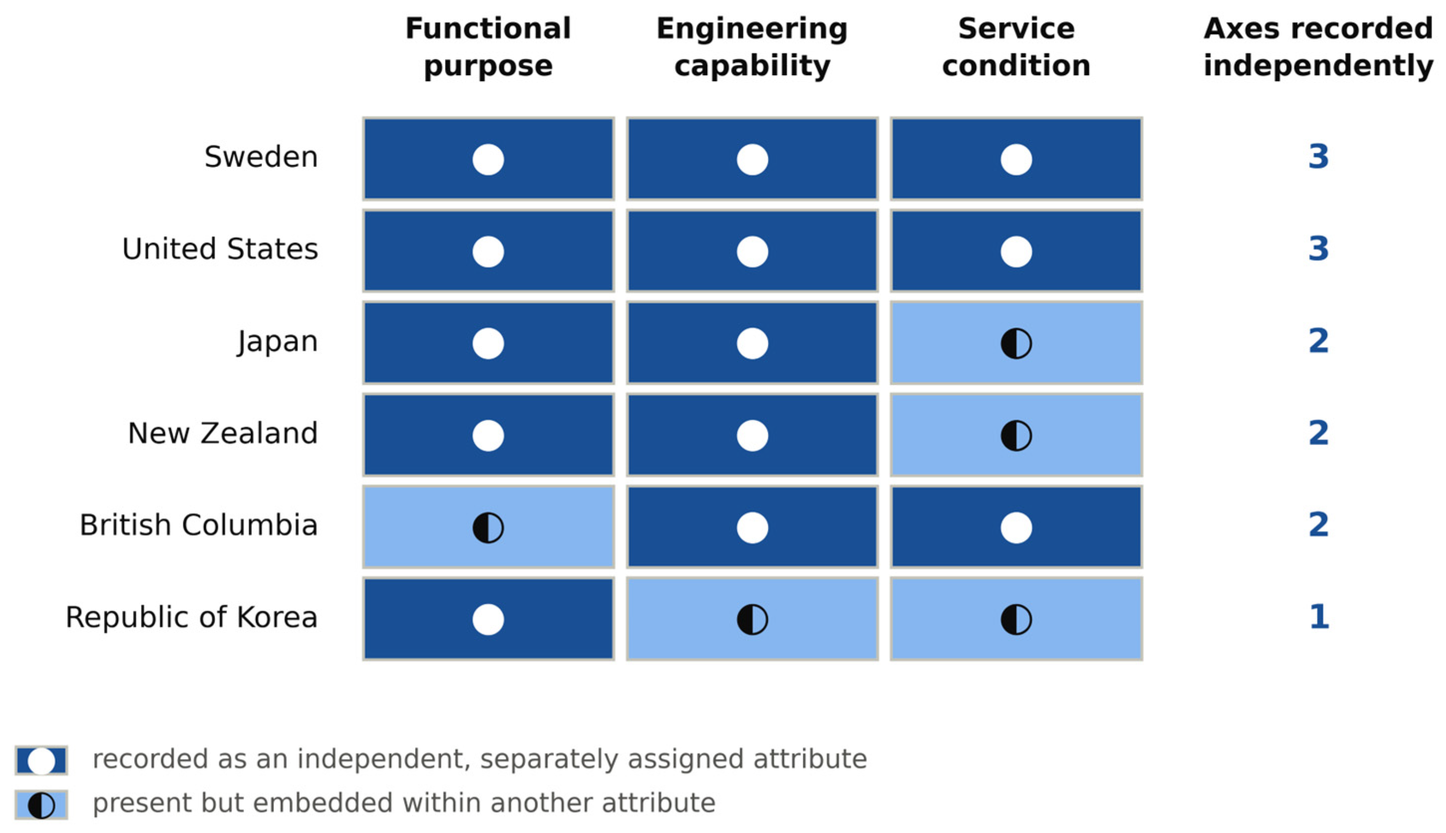
No universal numbered grade system was identified, and the numbered categories that exist are not equivalent. Japanese Grades 1 to 3 describe carriageway width and design vehicle; United States Maintenance Levels 1 to 5 describe the service currently provided; Swedish functional classes 7 to 9 describe transport importance. A numeral therefore carries no transferable meaning on its own. Aggregating the eight coded dimensions (
Table A1) to the three axes gives the pattern shown in
Figure 3.
The asymmetry lies between the axes rather than between the jurisdictions. Functional purpose is recorded as an independent road attribute in five of the six jurisdictions, all except British Columbia, and engineering capability in five of the six, all except the Republic of Korea. Service condition is recorded independently in only three: the United States, British Columbia and Sweden. Purpose and capability are routinely assignable to a road; condition frequently is not.
Aggregation to three axes discards information, and the underlying coding separates the six jurisdictions more sharply than the axes themselves do. Counting the dimensions of
Table A1 that are recorded as independent attributes gives the United States seven of eight, Sweden six, British Columbia five, Japan four, New Zealand three and the Republic of Korea one. The two readings agree at the extremes and differ in the middle: British Columbia records more independent attributes than its axis score suggests, because its route-specific engineering is detailed while its functional layer is weakly formalized. The axis scores should therefore be read as a summary of architecture rather than as a measure of how much a jurisdiction records.
No axis is entirely absent from any of the six systems, and this is the more informative finding. Where condition is not independently recorded, it is recorded at the wrong resolution or in the wrong form. Japan produces a four-tier soundness diagnosis for bridges, tunnels and shelter structures on a five-year cycle, but the rating attaches to the structure and never enters the road ledger, so it cannot be read off the road record. New Zealand ties maintenance priority to road class, so condition cannot vary independently of function. The Republic of Korea inspects each route twice a year and logs repairs, so its record shows what has been done rather than what the road currently provides. In each case the information exists within the administration; what is missing is a value attached to the road, at road or segment resolution, that can be varied and queried on its own.
The consequence of an axis being present but not independently assignable is therefore not that information is missing but that it is not addressable. Where capability is a property of the functional category, every road of a given function is implicitly assumed to have the same capability, and any road that departs from that assumption—an operational road carrying heavy timber traffic, or a wildfire-suppression road with a load-restricted bridge—cannot be described correctly at all. Only the Republic of Korea records a single axis independently, and both of its remaining axes fail in the same way: engineering requirements attach to functional road types rather than to roads, and condition is held as an activity log rather than as a state. Both follow from one feature of the system, where attributes are carried by the category rather than by the route.
3.3. Route Continuity and the Resolution of a Classification
The British Columbia material makes explicit a principle that is implicit in the other systems: the capability of a route cannot be determined from its average width or its typical condition, because a single low-capacity bridge, a narrow curve, a steep segment, inadequate vertical clearance or the absence of a suitable turnaround restricts the vehicle that can use the complete route [
34]. Capability is therefore a property of the weakest critical element, and the substantive contribution of the British Columbia approach is the identification and communication of that element rather than the assignment of a numeral.
This bears directly on how the second and third axes may legitimately be assigned. An engineering grade is meaningful only where the required performance is continuous over the whole classified route; where characteristics vary substantially, the route must be divided into management segments and coded segment by segment. Both records are needed, and they serve different users. The segment grades are retained, because they are what a maintenance or upgrading program acts on and what identifies the element that would have to be improved to raise the route. The route descriptor then carries the governing value, which is the grade of the most restrictive segment, together with an explicit identification of the element that governs it—a bridge, a curve, a gradient or a turnaround. A route is therefore described as, for example, G2 governed by a load-restricted bridge at a stated chainage, rather than as G2 alone. For timber-transport planning this is the operative distinction: the governing value states what vehicle may traverse the route today, and the segment record states what would have to be done, and where, for a larger vehicle to do so. The Swedish practice of recording passability and bearing capacity as segment attributes, and the British Columbia practice of posting structure-specific load limits, are two expressions of the same requirement. A classification that resolves only to the whole named road cannot carry capability or condition information reliably, whatever categories it nominally contains.
The Japanese case shows the same requirement from the other direction. Condition is assessed there with considerable rigor, but at facility resolution: a bridge carries a soundness diagnosis while the road that depends on it carries none [
29]. A route whose governing structure has been placed at the early-measure stage is, for operational purposes, in that condition, yet nothing in the road record says so. Resolution is therefore not a secondary implementation question. It is the difference between an attribute that can be acted upon and one that cannot.
It would nevertheless be wrong to read the Japanese arrangement as a defective one. If capability is a property of the weakest critical element, then so is condition, and the element is the correct place to record it: a soundness diagnosis belongs to the bridge and not to the kilometers of road behind it. What the framework identifies as missing is therefore not the measurement but the derivation—a rule that propagates the condition of the governing element to the route, in the same way that the route’s capability is already governed by its weakest structure. Read this way, the Japanese and British Columbian systems hold the same primitive and share the same gap, and a condition axis is not an additional survey burden but a computation over records that already exist.
4. Discussion
This section considers what the separation of the axes delivers operationally and what it costs, illustrates the diagnosis on one jurisdiction and then sets out the relationship to previous work and the limitations of the analysis.
The operational value of separating the axes is clearest where a decision must be made quickly and from the record alone. For the two demands identified in
Section 1, the record that matters is capability and condition rather than purpose: a functional designation confirms that a road was built for emergency access but not that the route currently accommodates the intended appliance, and timber-transport suitability turns on vehicle length, trailer off-tracking, axle load, bridge span, gradient, surface condition and seasonal bearing capacity rather than on the road’s name. Recording these attributes reduces the likelihood that a vehicle encounters an impassable curve, structure or turnaround only after entering the network.
Separating current condition from certified capability also makes maintenance prioritization tractable. Where the two are distinguished, budgets can be allocated against a combination of functional importance, engineering grade, current condition, traffic demand, emergency value and environmental risk, and the increasingly automated condition assessment methods now available [
6,
7] have a defined attribute to populate. The same separation permits transparent upgrading and downgrading: a road may be raised to a higher service level before harvesting or during a high-risk fire season and returned afterwards, or placed in storage without deleting its functional and engineering history. An explicit axis structure is also what makes forest-road attributes interoperable with the spatial databases and automated inventories toward which road records are moving [
8,
9,
19], and with the separate attribute families already used in general road asset management [
14,
15].
Introducing an explicit capability axis carries an evident risk of being read as a mandate to widen, straighten, surface or pave every forest road. That reading would be mistaken and environmentally counterproductive, given the documented effects of forest roads on erosion, drainage, habitat connectivity and human disturbance [
3,
4,
5]. The purpose of the axis is the opposite: to match road performance to demonstrated management need, and thereby to make it possible to justify not upgrading a road whose function does not require it. The governing principle is that the minimum engineering grade sufficient to perform the designated function safely should be assigned and constructed. Where a road serves several purposes at once—timber transport, routine forest management and wildfire response—the principle operates on the set of uses rather than on the primary designation. The sufficient grade is the one that satisfies the most demanding operational use the road is intended to carry, because a grade adequate for the nominal function but inadequate for an actual use is not a lower grade but a wrong one. This is a further reason for holding capability separately from function: a single functional label cannot express that a road designated for forest management is also the designated haul route for a particular coupe, whereas a capability value set from the governing use can. Where the most demanding use is occasional rather than routine, the proportionate response is a temporary restriction or a permit for that movement rather than a permanent upgrade, which the condition axis records without altering the certified grade.
Several safeguards follow from that principle: applying the lowest grade that safely satisfies the function, evaluating traffic control before physical upgrading, permitting seasonal use where year-round access is unnecessary, using load restrictions where structural upgrading is not justified, integrating drainage, erosion, slope-stability and aquatic-connectivity requirements into the definition of each grade rather than treating them as separate compliance and reassessing function and grade periodically. Road storage, closure and decommissioning should be retained as legitimate management outcomes rather than treated as failures, and an explicit condition axis is what makes this administratively possible, since a road placed in storage retains its recorded function and certified grade and can be reopened without re-establishing its history.
One qualification should be entered against the argument of this section. Fusing the axes is not simply an error. A single category is cheap to assign, cheap to audit and easy to communicate, and where administrative capacity is limited that economy is a reason rather than an oversight. The claim made here is narrower: fusion carries a determinate cost, which is that capability and condition become unaddressable, and a system that fuses should do so in knowledge of what it forgoes rather than because the alternative was never articulated. Stated at a general level, the separation offers three advantages and imposes three costs. It allows capability and condition to be read off the record, so that a vehicle movement or an emergency response can be planned without a site visit; it allows condition to change without disturbing function or certified grade, so that storage, seasonal restriction and reopening become ordinary administrative acts rather than reclassifications; and it makes forest-road attributes interoperable with the separate attribute families already used in general road and bridge inventories. Against these, it requires three attributes to be assigned and maintained where one was assigned before; it requires a resolution finer than the named road wherever characteristics vary along a route, which increases the number of records; and it requires an administrative rule for re-certification, without which the boundary between capability and condition is not operable. Whether the advantages justify the costs is a judgement for each jurisdiction, and the framework is a means of making that judgement explicit rather than an argument that separation is always warranted.
The Republic of Korea illustrates the diagnosis and the remedy, and is used here as a worked example rather than as the subject of the paper. The 2025 restructuring is itself an instance of the difficulty. A functional distinction that could not be sustained in administration was removed, and a new policy priority was accommodated by creating a further functional category bound to its own design standard, rather than by varying an engineering attribute that any function could carry. Its functional categories should be retained, because they communicate a policy purpose that cannot be recovered from physical measurement. What the comparison indicates is supplementation rather than replacement. Applying the framework, the functional axis is retained as wildfire-suppression (W), trunk (T) and operational (O); an engineering axis is added with a strategic or high-performance grade (G1), a standard forest-management grade (G2) and a limited or low-volume grade (G3); and a condition axis is added with stored or closed (M1), restricted or seasonal (M2), routine operational service (M3) and strategic high readiness (M4). The letter O denotes an operational road and not a numeral zero. The condition axis would require less new activity than it might appear: the twice-yearly route inspection already mandated [
39] would populate it directly, and the change is one of what is stored, converting an intervention history into a current state that can be queried.
Because the axes are independent, a wildfire-suppression road would not be automatically classified as G1. Its grade would follow from the variables set out in
Section 2.3 —the required design vehicle, route geometry, structures, terrain and response role—and an operational road used for heavy timber transport might equally require G1 or G2 capability. Consistent with
Section 3.3, the required standard must hold continuously over the classified route, and a route whose characteristics vary substantially should be divided into management segments, as illustrated in
Table 5.
Certified grade and current condition should remain separate records, so that a temporary defect changes the service level without altering the certified grade, on the rule and the worked case set out in
Section 2.3. A road record supporting this distinction would hold the certified grade, the current maintenance level, any temporary restriction, the allowable vehicle or load, identified defects, the inspection date, required repairs and restoration status, together with upgrading, downgrading and closure history and the responsible management authority. Roadside signs need not reproduce the record; the combined descriptor, the governing vehicle or load restriction, seasonal access status and the distance to the nearest turnaround are sufficient at the roadside.
The Act on the Installation and Management of Forest Roads, promulgated in May 2026 and entering into force in May 2027, establishes an independent legal basis for systematic forest-road planning, installation, maintenance, administrative responsibility, protection and use [
24], and therefore provides a vehicle for incorporating capability and condition attributes into subordinate regulations, technical standards and road records. Foreign numerical criteria should not be transferred directly. The same diagnostic procedure is in any case available to the other jurisdictions examined, and yields a different prescription in each: Japan records purpose and capability but holds condition at facility resolution, so the remedy there is a propagation rule rather than an engineering grade; New Zealand derives maintenance priority from class, so the remedy is an independent condition attribute; British Columbia records capability and restriction in detail but formalizes function weakly, so the remedy lies on the first axis. The framework prescribes no categories and no thresholds in any of these cases.
This study extends the Korea–United States comparison of Rhee et al. [
20] by examining six jurisdictions and by focusing on the internal architecture of classification systems rather than on road density, budgets and national policy direction. It differs from Rodrigues et al. [
21] in emphasizing operative legislation, engineering manuals and institutional classifications rather than the use of classification in academic planning studies, and from Pohle and Jaeger [
22], whose international guideline comparison concentrated on drainage and water management. It is complementary to spatial approaches to network planning and accessibility assessment [
2,
23], which address where roads should be and how far the estate is from them, whereas the present analysis addresses what an existing road is recorded as being able to do. Its contribution relative to general road administration is not the three-way separation itself, which is already standard practice in national road and bridge inventories [
14,
15], but the finding that forest-road systems routinely fuse dimensions that general road administration keeps apart.
Several limitations qualify the findings. The study is a purposive comparative analysis rather than a systematic review and does not claim to identify every relevant instrument or jurisdiction. The European coverage is the clearest instance. Only Sweden was examined, and the Nordic forest-road context—long haul distances, a developed contractor haulage sector and a national road database built for timber transport—is not representative of European forestry as a whole. Central European systems, Germany and Poland among them, operate under different ownership structures, terrain and traffic regimes, and the framework has not been tested against them. Because the six cases were selected to maximize contrast in classification logic rather than to represent regions, adding a further European jurisdiction would test the framework rather than complete a sample; it is for that reason listed below as the first line of further work rather than presented as a gap that the present proportions conceal. The framework is specified a priori and is therefore an instrument rather than a discovery; the analysis cannot establish that three axes are the only or the best decomposition, because a fourth dimension not represented in the coding instrument could not have been detected. The design is not an out-of-sample test: the six jurisdictions to which the framework is applied are the same six used to illustrate it, and applying it to a jurisdiction held out of the present set remains necessary. Official regulations and manuals describe formal requirements and do not establish how consistently those requirements are applied in the field, and regional, ownership-specific and company-level systems may depart from the national instruments examined. Terminology differs among Korean, Japanese, English and Swedish sources, and terms such as grade, class, service level, passability, accessibility and bearing capacity may not have exact equivalents, which the coding rules in
Table 3 mitigate but cannot eliminate. The documents were selected and coded by a single author; publishing the rules and the complete coding makes the procedure auditable, but independent coding could identify additional distinctions or alternative readings.
Finally, and most importantly for how this paper should be read, no empirical validation is presented. The framework is an analytical and diagnostic instrument, and the category structure illustrated above is conceptual. Neither is offered as a complete forest-road classification system, and neither should be adopted as one: no numerical criteria are established here, no segment has been surveyed, and no proposed grade or condition level has been tested against a road. What the analysis supports is a claim about what six documented systems do and do not record, and a conditional claim about what would follow from recording the three axes separately. Any operational classification derived from the framework would require the empirical validation set out below before it could be used.
Two of these limitations bear directly on specific results and should be stated precisely. First, it was not possible to reach the same level of the authority hierarchy in every jurisdiction: Sweden and New Zealand are evidenced principally on sector-body guidelines, whereas the Republic of Korea is evidenced on statute and enforcement rule. Because sector-body instruments are typically more operational than primary legislation, the axis representation reported here may in part reflect how far down the hierarchy comparable documents were available rather than how each jurisdiction manages roads in practice. Second, three of the codings reported here were settled only after examining instruments below the level at which the comparison began, and the same may be true of others: the United States’ capability codes rest on the road-management objective recorded in the agency database rather than on the maintenance-level guidance, the Japanese condition code rests on facility inspection manuals rather than on the Forest Road Regulations, and the Korean condition code rests on a Korea Forest Service directive rather than on the Enforcement Rule. A code of ○ in
Table A1 should accordingly be read as an absence in the instruments examined and not as a demonstrated absence in the jurisdiction. One coding remains genuinely open: whether the annual forest-road inspection and evaluation carried out in the Republic of Korea under the annex to that directive yields a recorded condition grade could not be established from publicly accessible sources, and were it to do so the Korean condition code would rise.
A rival explanation of the pattern should also be stated. The jurisdictions that record the most axes independently are those in which large timber volumes move over the network and the cost of that movement falls on the transport operator; the Republic of Korea, where public works funding and small private holdings predominate, records the fewest. Axis separation may therefore be a function of who bears haulage cost rather than of classification philosophy, in which case the institutional remedy discussed in
Section 4 would be necessary but not sufficient. The present design cannot discriminate between the two explanations, because ownership and haulage structure were not selection variables. Jurisdictions that combine fragmented private ownership with a developed haulage sector, Austria and Finland among them, would provide the natural test.
The selection criterion warrants a similar caution. Jurisdictions were chosen to maximize variation in classification logic and the analysis then reports variation, which would be circular if the two were the same thing. They are not: what was selected for was that the systems differ, whereas what is reported is which axes they differ on and which they share. That purpose is recorded almost everywhere while condition is recorded in half the cases was not a selection criterion and could not have been known in advance. The result is nevertheless conditional on the sample in the ordinary way, and the proportions given in
Section 3.2 describe these six systems rather than estimating any wider population.
Three lines of further work follow directly. The framework should be applied to jurisdictions held out of the present set, particularly those with ownership structures and forest types unlike the six examined here, both to test its sufficiency and to provide the out-of-sample evidence this design does not supply. The category structures should be validated empirically on representative road segments using design-vehicle swept-path analysis, bridge-load assessment, maintenance-cost analysis and seasonal-access monitoring, with consultation of forest road, wildfire-response and timber-transport specialists. And the interaction between an explicit axis structure and automated condition assessment deserves attention, since methods that detect road damage remotely [
6,
7] can populate a condition axis continuously only if that axis exists as a defined attribute. Finally, the scope boundary drawn in
Section 2.3 invites its own test: whether environmental sensitivity behaves as a fourth axis, assignable to a road and varying independently of the other three, or whether it is better handled as a constraint on what may be done to a road, is an open question that the present analysis was not designed to answer.