Article

Site Selection of Wind Farms in Poland: Combining Theory with Reality

Faculty of Civil Engineering and Environmental Sciences, Białystok University of Technology, Wiejska 45E, 15-351 Białystok, Poland
*
Author to whom correspondence should be addressed.
Energies 2024, 17(11), 2635; https://doi.org/10.3390/en17112635
Submission received: 7 May 2024 / Revised: 27 May 2024 / Accepted: 27 May 2024 / Published: 29 May 2024
(This article belongs to the Special Issue Recent Development and Future Perspective of Wind Power Generation)

Abstract

:
With global shifts towards sustainable energy models, the urgency to address rising fossil fuel prices, military conflicts, and climate change concerns has become evident. The article aims to identify the development of wind energy in Poland. This study introduces an integrated methodology for enhancing renewable energy capacities by selecting new construction sites for onshore wind farms across Poland. The proposed methodology utilises a hybrid model incorporating multiple criteria decision-making methods, such as the Analytic Hierarchy Process (AHP) and Technique for Order of Preference by Similarity to Ideal Solution (TOPSIS), alongside the semiautomated spatial analysis method using QGiS software (v. 3.32 Lima). The model considers economic, social, and environmental criteria and limitations, offering a comprehensive approach to the decision-making process. It was found that wind farms occupy 460.7 km2 in Poland, with a 250 m buffer around each turbine and a total power capacity of 5818 MW. The results show that an additional 7555.91 km2 of selected areas, 2.34% of the country’s area, theoretically offer significant opportunities for wind energy development. The spatial analysis identifies potential sites with promising opportunities for domestic and international renewable energy investors. The study’s findings contribute towards achieving national and EU renewable energy targets while offering a replicable framework for informed spatial planning decisions in other regions.

1. Introduction

Governments globally are shifting towards sustainable energy models in response to the urgent challenges of rising fossil fuel prices [1,2], military conflicts, and escalating climate change concerns [3]. This transition is evident through increased investments in diverse renewable energy projects, encompassing hydro [4,5], solar [6,7], wind [8,9], geothermal [10,11], biomass [12,13], and wave energy [14,15].
Wind power, known for its reliability and cost-efficiency, is a prominent source of renewable energy production. Wind and hydropower contributed over two-thirds of Europe’s renewable electricity (37.5% and 29.9%, respectively) [16]. In 2022, Europe added 19 GW of wind power capacity, with 16 GW installed in the EU-27 countries. The total electricity generated from onshore and offshore wind farms was 489 TWh in 2022 [17]. The solar energy sector has developed significantly and is comparable to wind power in total built capacity, which is 41.4 GW [18]. However, despite having increased capacity, the solar sector produced much less energy than wind power. In 2022, it produced only 210.3 TWh, which accounts for 18.2% of the total electricity generated from renewable sources in Europe [16]. To achieve the union’s objectives of production from renewable energy sources by 42.5% in 2030 [19], the EU-27 should build an additional 30 GW of new wind installations each year [17]. Poland’s share of renewable energy has increased to 16.9%, a 1.2 pp improvement from 2021 [16]. It is lower than the average EU share (23%) [16]. The situation in Poland will change in the following years after the liberalisation of local environmental laws in 2023 [20,21].
Wind energy has gained prominence as a renewable energy source due to its minimal environmental impact compared to conventional electricity production [22,23]. Beyond environmental benefits, the advantages of wind energy are accompanied by challenges. Established exclusion criteria for wind farms involve visual impacts, threats to bird life, air traffic safety, noise concerns, and public acceptance [9,24]. Protected areas, forests, water surfaces, high-productivity agricultural regions, and key infrastructural zones are often excluded from the siting process [25,26]. However, the global development of wind farms indicates its status as a significant and growing renewable energy source. Choosing suitable locations for wind farms involves a complex analysis of numerous criteria, necessitating the consideration of economic, technological, ecological, and social factors [27].
This study introduces an integrated methodology that enhances renewable energy capacities by selecting new construction sites for onshore wind farms. The methodology utilises a hybrid model that incorporates multiple criteria decision-making (MCDM) methods such as AHP and TOPSIS and geographic information systems (GIS) using QGiS software. The model considers economic, social, and environmental criteria and limitations, offering a comprehensive and systematic approach to the decision-making process.
This paper represents the third stage of scientific research on spatial planning and wind farm siting. The authors, in the first stage, reviewed the frequency of application of different criteria (bird’s and bat’s paths, protected areas, slope, acoustic influence, airports, distance to road, cultural values, roughness, wind speed, etc.) and mathematical methods (AHP, VIKOR, TOPSIS, ANP, DEMATEL), where the most commonly used methods (AHP, TOPSIS) were selected for further research [9,25,28,29,30,31,32,33,34]. In the second stage, special attention was given to mathematical methods, where multi-criteria analysis methods such as AHP, TOPSIS and Borda were described in detail and applied to wind farm siting [8,35,36,37,38,39,40,41,42,43]. After defining and selecting the necessary location criteria, this paper focuses on mathematical modelling and spatial analysis to assess the development of renewable energy sources in one of Poland’s regions.
The proposed methodology applies a standardised set of criteria in adjacent regions to Poland, facilitating comparative analysis of onshore wind potential. The study’s outcomes are anticipated to offer valuable insights for policymakers and decision-makers, augmenting legislative instruments for effective spatial planning on the local level. This research contributes to informed decisions concerning onshore wind projects, propelling the transition towards a more sustainable and resilient energy future in the Polish region.
The research’s primary contribution lies in developing and testing a sophisticated spatial decision-making model, offering a valuable strategic decision-making tool in Polish wind energy development. By applying different multi-criteria methods, the model ensures an empirically sound evaluation of criteria, and the study’s scientific contribution includes applying AHP and TOPSIS optimisation methods and GIS algorithms to address the complexities of wind farm location selection. The research’s application and validation on a state scale demonstrate its potential impact on spatial planning and wind energy construction projects.
Scientists, in their research, focus on presenting the set of criteria they have chosen to analyse, as well as multi-criteria analysis methods. On the other hand, the result of such analyses is maps showing potential locations for renewable energy development. In the literature, there is a gap in the description of the process of creating these maps in special programs, when in some cases, not even the name of the GIS software itself is mentioned. This paper’s novelty lies in describing the steps to create a semi-automatic algorithm for spatial analysis using the QGiS software (v. 3.32 Lima), which is the next important part of the work to find the best locations for renewable energy sources. When the necessary set of criteria and their values are selected after a multi-criteria analysis, semi-automatic spatial analysis speeds up selecting suitable locations for wind farm constructions. This approach shortens the project development time, reducing production costs and increasing the project’s profitability. The construction of wind farms can be speeded up, which leads Poland to reduce its dependence on fossil fuels and handle the effects of climate change.

2. Materials and Methods

2.1. Study Area

Poland is in Central Europe, bordering Germany to the west, the Czech Republic and Slovakia to the south, Ukraine and Belarus to the east, and Lithuania and the Russian exclave of Kaliningrad to the northeast [44]. The Baltic Sea defines the northern boundary. A variety of terrains characterises Poland’s landscape. The northern regions are marked by coastal plains and dunes. At the same time, the central part consists of the vast Polish Plain, which is primarily flat with occasional uplands and lakes, notably in the Masurian Lake District. The southern part of the country is dominated by mountainous regions, including the Sudetes and the Carpathians, with the Tatra Mountains being the highest range, peaking at Rysy at 2499 m [45].
Poland’s climate is predominantly temperate, influenced by maritime and continental weather patterns. Due to the maritime influence, the western part of Poland tends to be warmer and wetter. At the same time, the eastern areas experience a more continental climate characterised by greater temperature extremes and lower precipitation. Winters can be cold, particularly in the eastern and northeastern regions, where temperatures often drop below freezing [46]. The summer season typically brings warm weather, with temperatures falling between 18 °C and 30 °C and can exceed 35 °C [47].
Poland boasts a rich and varied environment comprising 23 national parks [48], over 1400 nature reserves, and diverse forms of protected landscapes [49]. Among the notable national parks are Białowieża National Park [50], which contains Europe’s last primaeval forest and has the European bison populations, and Tatra National Park [51], known for its alpine scenery and diverse flora and fauna. The country also features significant river systems, including the Vistula, the longest river in Poland, and the Odra, which forms part of the western border. Wetlands and marshes, especially in the Biebrza [52] and Warta River [53] valleys, support a wide array of bird species and other wildlife.
Poland, like many other countries, grapples with environmental challenges. These include air and water pollution, deforestation, and the impacts of climate change [54]. Poland is actively combating them through governmental policies, international cooperation, and promoting renewable energy sources. This proactive approach instils hope for a greener, more sustainable future [55].
Poland’s administrative structure is well-organised [44]. The country is divided into 16 provinces, known as voivodeships. Each voivodeship is further subdivided into counties and municipalities. The capital city, Warsaw, located in the Mazovian Voivodeship, is the largest city and serves as the country’s political, economic, and cultural hub.
The administrative system in Poland is decentralised and designed to promote local governance and regional development. This structure balances local autonomy and national oversight, facilitating coordinated efforts in education, infrastructure, and public services.

2.2. Materials

The article utilises data from the National Database of Topographic Features at a 1:10,000 resolution, known as Bdot10k [56,57,58], a representation of terrain in digital form (DEM) [59,60], different forms of safeguarding the environment’s surface in Poland managed by the General Directorate for Environmental Protection (GDOŚ) [61], the map of flood-risk areas (ISOK project) developed by the organisation known as the Institute of Meteorology and Water Management (IMGW) [62,63], the gridded map for land cover classification overseen by the European Space Agency and Copernicus Services [64], the table of land cover classes utilised in the gridded map for land cover classification [65], maps depicting average wind speed and air power density at 100 m overseen by the Global Wind Atlas [66], and locations of currently built wind farms in the region from OpenStreetMap [67] (Table 1).
The Bdot10k database includes 15 layers with data (and abbreviations) about the water network (rivers and springs—SWRS, channels—SWKN, drainage ditches—SWRM, wetlands—OIMK, surface water—PTWP), urban areas (buildings—PTZB and BUBD), power grid—SULN, roads—SKDR, forests—PTLZ, permanent crops—PTUT, sacral complexes—KUSC, historical complexes—KUZA, territorial divisions—ADMS and excavations and heaps—PTWZ.
Surface forms of nature protection in Poland include 10 types of protection areas: national parks, reserves, areas of the Natura 2000 network (SAC, SPA, considered as two objects), landscape parks, protected landscape areas, natural landscape complexes, ecological sites, monuments of nature, and documentation posts [68].

2.3. Methods

The multi-criteria decision analysis (MCDA) is a powerful tool for determining a set of viable solutions and identifying the optimal solution based on a predefined set of criteria [69]. This method falls under the umbrella of multi-criteria optimisation, where the decision variables are limited to a finite set of values. The selection process is influenced by several factors that significantly impact the implementation and performance of the chosen solution [70]. These factors act as criteria which can either enhance or detract from the suitability of a particular option. Each criterion is assigned a unique preference, which ultimately affects the outcome of the multi-criteria analysis. The criteria used to inform the decision-making process are carefully evaluated and measured.

2.3.1. The AHP Method

The AHP method is highly adaptable for solving various decision-making problems [71,72,73]. With this method, the evaluations of options and criteria are typically subjective, reflecting the unique preferences of the decision-maker. The preferences and objectives of the decision-maker can significantly impact the results of the multi-criteria analysis. The AHP technique offers the benefit of simplifying the combination of assessments of both quantitative and qualitative criteria [38]. Criteria are assessed pairwise, evaluating their relative importance within a specific level of the decision hierarchy. These assessments use a defined Saaty scale [74] (pp. 5–7). One of the distinctive features of the AHP method is its approach to weighting criteria and decision options. Unlike other multi-criteria decision-making methods that directly assign numerical weights, the AHP method relies solely on pairwise comparisons. Each element within the decision hierarchy is compared to every other element at its level, resulting in relative preference judgments. These judgments are then translated into weights through a mathematical process, ensuring consistency and transparency in the weighting process [35].
The AHP method follows a five-step process [35]: it builds a hierarchical model, breaking down the problem into key components and setting priorities among them. Experts then compare each element at each level against one another, highlighting strong and weak points. Based on these comparisons, the method uses a mathematical approach to determine the relative importance of each element. The method checks for inconsistencies in their comparisons. Finally, the method ranks the available choices by combining the importance weights with the experts’ preferences for each option.

2.3.2. The TOPSIS Method

TOPSIS is an easily understood and applied method, making it a user-friendly approach [42,43]. One of the significant benefits of TOPSIS is its ability to integrate both quantitative and qualitative factors, rendering it a flexible tool for various decision-making contexts. However, it is important to acknowledge that TOPSIS may not be the optimal choice for all circumstances due to its sensitivity to alterations in criteria weights and its reliance on certain assumptions about linear relationships. Despite these potential limitations, TOPSIS has demonstrated its effectiveness in numerous domains, such as project selection [75,76], supplier evaluation [77,78], product design [79,80], environmental management [81,82], and healthcare [83,84].
The implementation of the TOPSIS method is a 7-step approach compiling a list of potential choices and the factors for further evaluation. It is essential to assign weights to each criterion based on its level of importance, as not all criteria hold equal value. Next, create a table with rows representing each alternative and columns representing each criterion. Fill in the table with values that reflect how well each option performs. To ensure fairness in the evaluation process, normalise the data so that all criteria are measured on the same scale. Finally, rank the options, calculating each option’s relative closeness score based on its distances to the ideal and negative-ideal solutions. The alternative closest to the ideal preference is considered the best.

2.4. Semiautomated Spatial Analysis Method

The objective of a semiautomated method is to systematically apply an array of diverse processes and transformations to a given dataset, either by following a predetermined path or through iteration. When consolidated into a single model, these processes become more efficient, requiring less time and effort, and can be easily replicated on other datasets [85]. This chapter aims to set up, via the graphical modeller, a part of the open-source software QGiS [86], a semiautomated workflow based on vectorial datasets to identify the optimal areas for installing new wind farms in Poland.
This process cannot be fully automated because of software limitations. In QGiS software, the resulting outputs from the first step of spatial analysis cannot be used as input in the second step. That is why the algorithm required to identify the optimal regions for installing new wind farms is grouped into six main steps.

2.4.1. Semiautomated Spatial Analysis

The two initial steps were connected with the preparation of Bdot10k objects. The first step was using the Bdot10k database to merge all types of objects divided into counties, such as forests, rivers, and others. Then, some of the merged Bdot10k object files for the whole voivodeship area were filtered to remove unnecessary information from the attribute’s tables, such as eliminating data about low-voltage lines in the region from the SULN layer (Figure 1).
The second step was to create buffer zones around each merged object from the Bdot10k database at the voivodeship scale. Before creating buffer zones, it was crucial to ensure that the Bdot10k database was thoroughly reviewed and cleaned to remove any inconsistencies or inaccuracies. This allowed the preparation of one merged layer for all objects with an exclusion zone for this database (Figure 2). Once the data were prepared, they were integrated into a GIS platform along with other relevant spatial datasets, such as a map of slope, roughness, mean wind speed, and power density of air, to provide a comprehensive framework for analysis.
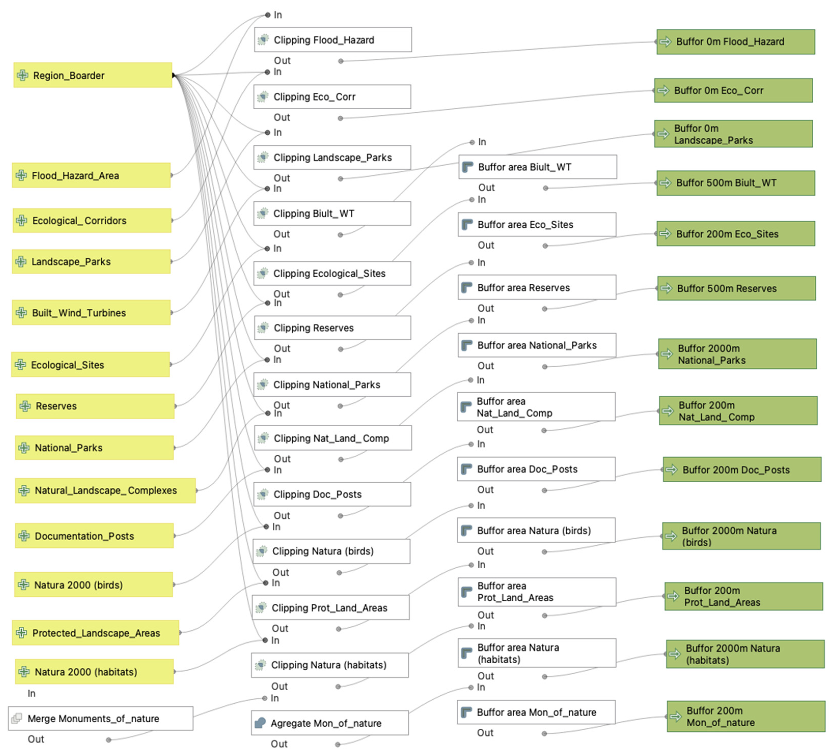
In the third step, the buffer zones were established for each form of nature protection and already built wind farms in Poland (Figure 3). By doing so, in a further step, a unified layer was created that includes an exclusion zone for this dataset.
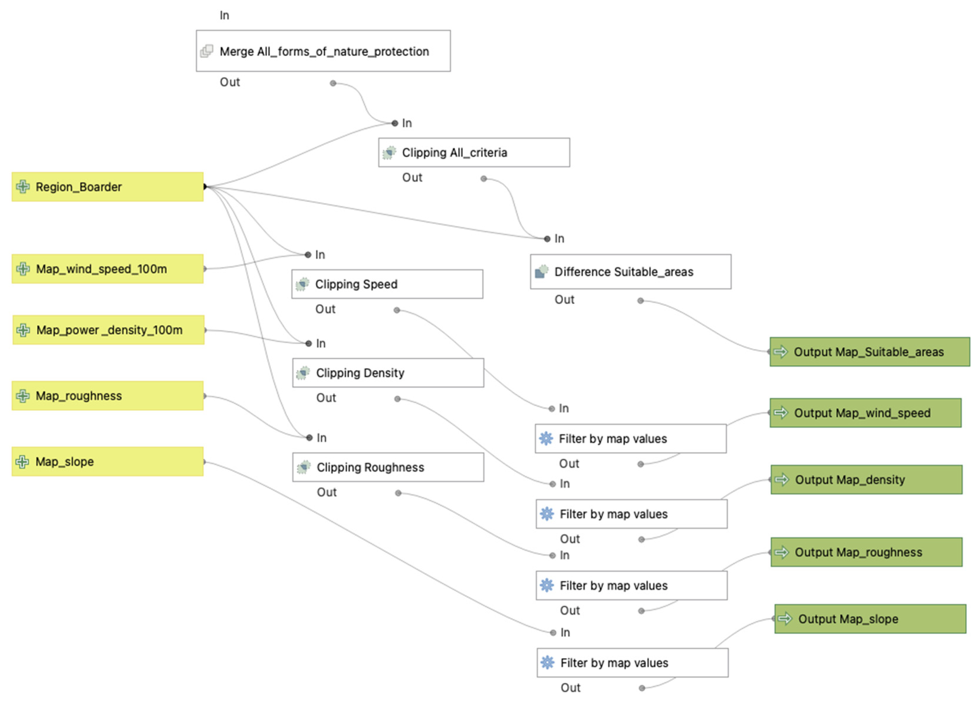
In step four, all forms of nature protection and wind farms that had already been built from the previous step were combined into one layer. Then, this layer was clipped with the voivodeship boundary, as the input files were created for the whole country. By finding the difference between the merged layer of nature protection forms and the voivodeship boundary, a map of suitable areas for constructing wind farms according to ecological criteria was created (Figure 4).
Additionally, in this step, four maps were prepared for the final step, namely: a map of average wind speed at a height of one hundred metres, a map of air density at a height of one hundred metres, a map of land surface roughness, and a map of terrain slopes. These maps for the whole country were clipped to the voivodeship boundary and filtered from unnecessary information. The following filtering was applied to these maps: for the map of average wind speed, the data on areas with values of 8 m/s and higher were left; for the air density map, 500 W/m2 and above were left; for the land surface roughness map, roughness classes 1, 1.5, and 2 were left; values from zero to three degrees were left for the terrain slope map (Table 2).
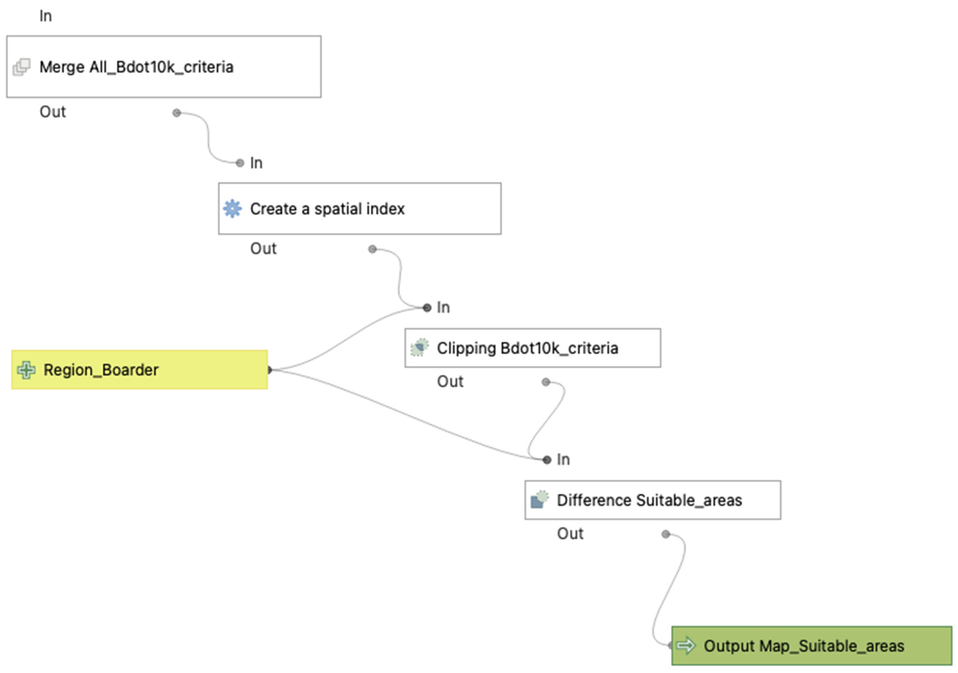
In step five, all objects of the Bdot10k database were merged into one layer, as was done in the previous step for all forms of nature protection. Then, a spatial index was created for the resulting file to speed up work with it. Next, this layer was clipped along the voivodeship boundary, as the created buffer zones of individual object types may extend beyond it. By finding the difference between the merged Bdot10k database layer and the voivodeship boundary, a map of areas suitable for wind farm construction according to the Bdot10k database criteria was created (Figure 5).
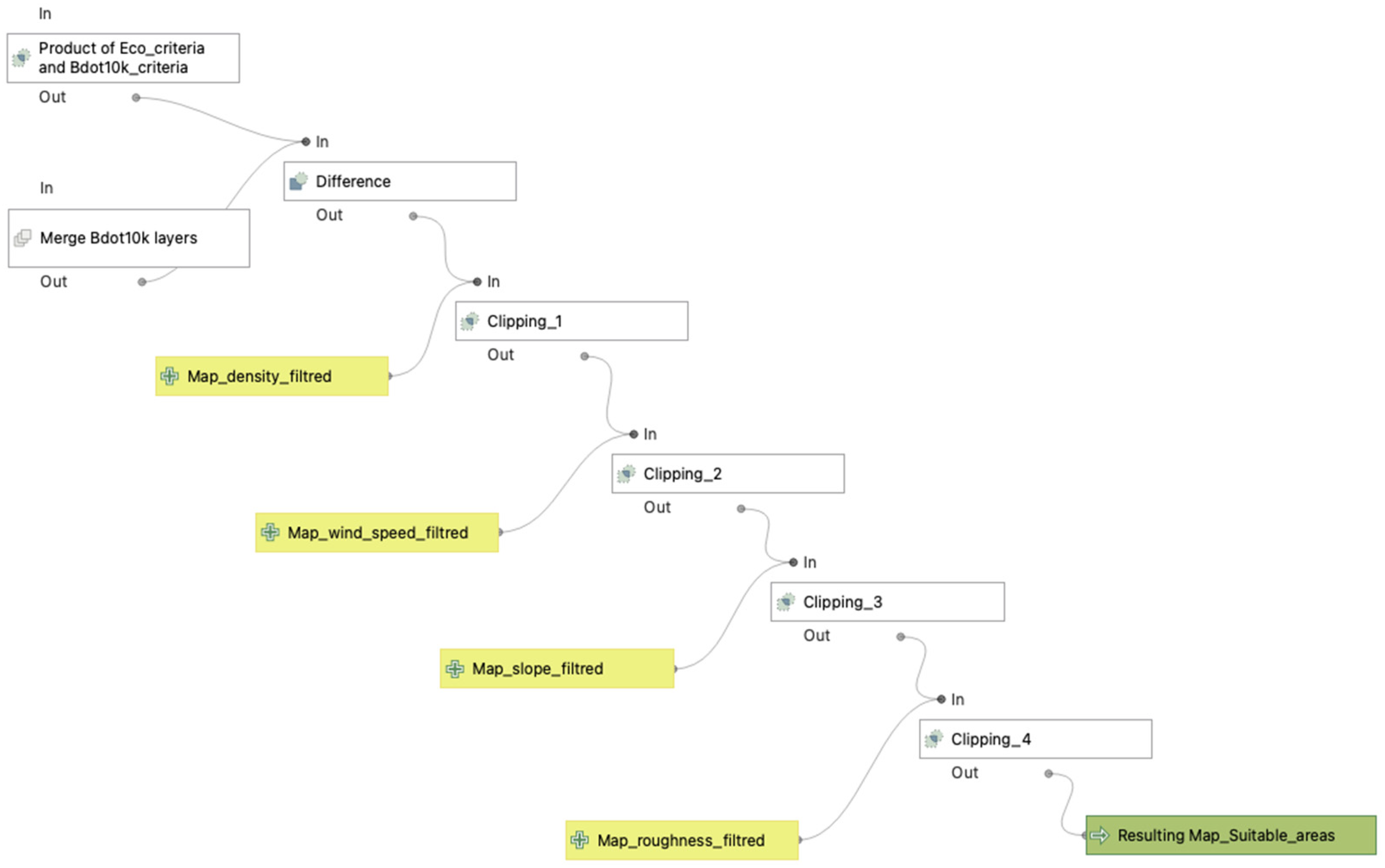
The final step of the semiautomated spatial analysis consisted of the following operations: comparing the resulting maps for nature protection forms and the Bdot10k database to find common areas; removing from the resulting map the layers from the Bdot10k database for which no buffer zones were created (sacral complexes—KUSC, historical complexes—KUZA, territorial divisions—ADMS and excavations and heaps—PTWZ). Then, the exclusion of unsuitable areas from the intermediate map based on filtered maps of mean wind speed, air density, terrain slope, and roughness of the ground surface follows. All these operations have resulted in a map of potential locations for wind turbines in one voivodeship (Figure 6).

3. Results

3.1. Mathematical Modelling and Preliminary Results

The proposed hybrid model requires the use of multi-criteria decision-making analysis to achieve the paper’s goals. Two MCDM methods (AHP and TOPSIS) are utilised to avoid errors in the process. This approach enables a comparison of the modelling results of the two methods, allowing for adjustments to be made to the model if needed. If the results are the same or differ slightly, the best variant will be used in spatial analysis.
Before the spatial analysis, the mathematical models used a group of 11 criteria (Table 2) compared with the 6 variants typically used by scientific authors and RES developers in their work. These criteria were carefully selected and adapted to Polish conditions based on the authors’ previous work [8]. Through modelling efforts, the authors identified the best option for the set of criteria (Table 2).
Three criteria, namely protected natural areas, urban areas, and water bodies, are grouped and contain sub-criteria in Table 3. Each sub-criterion has the same meaning as the main group criterion, except for the sub-criteria of the protected areas group due to legal restrictions in Poland [20,68]. The values for protected areas in Table 2 represent distances to Natura 2000 areas. The criteria used in the mathematical modelling (Table 2) are then used as GIS layers in QGiS to create buffer zones (Table 3).
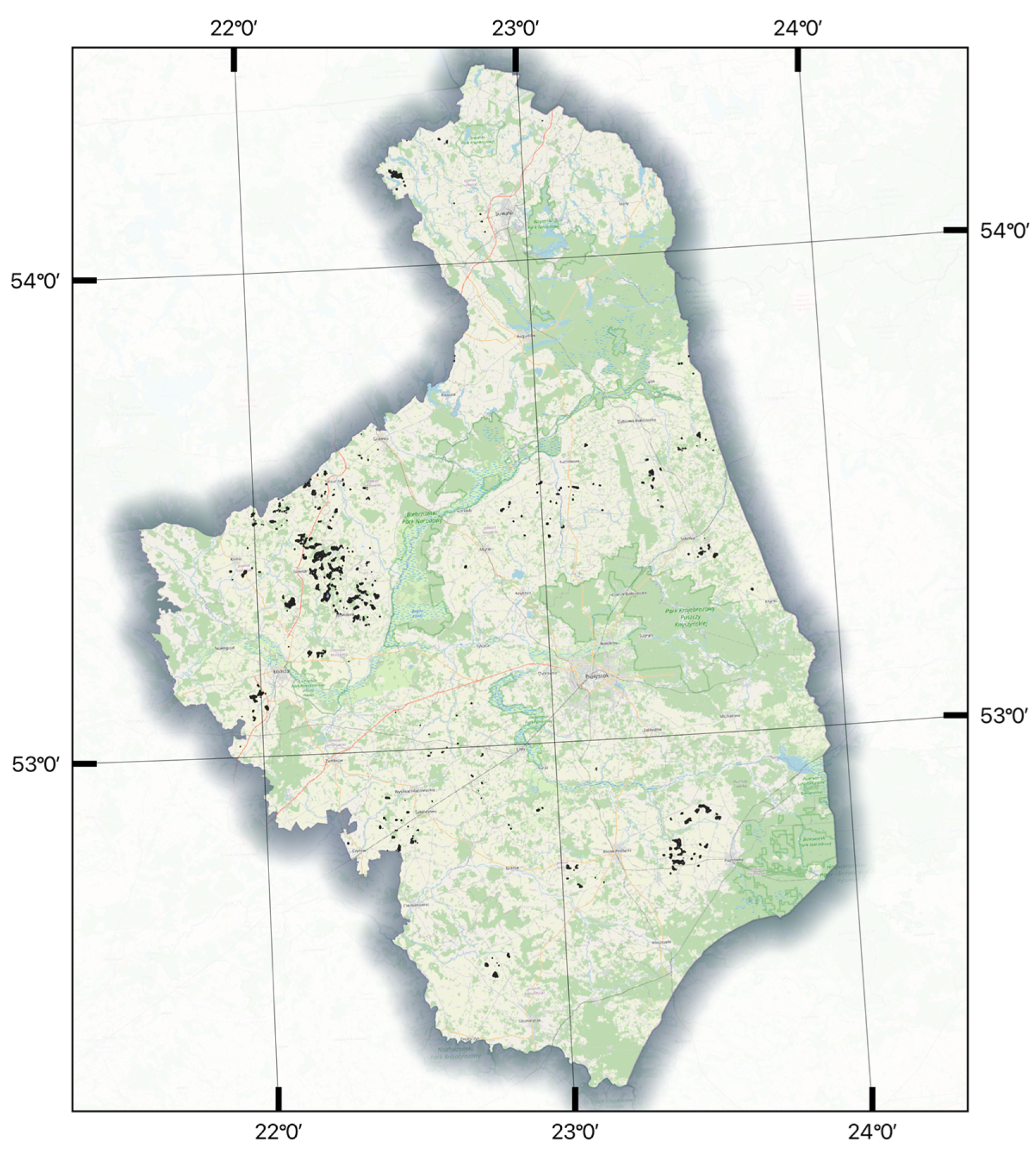
The study area for preliminary research was Podlaskie voivodeship. The total area is 20,186.8 km2, and the average area of the 14 counties within it is 1427.6 km2. In the area of the Podlaskie voivodeship, wind farms occupy the surface of 52.35 km2 with a power capacity of 211.9 MW. Following our research, a comprehensive site-selection process shows that an area of 32.50 km2, which is 704 plots, representing 0.16% of the voivodeship, can theoretically increase the voivodeship’s power capacity by 131.5 MW (Figure 7). The spatial analysis revealed that the Podlaskie voivodeship has the most suitable sites for wind farm construction with a total area of 21.53 km2 close to three districts, Łomżynski, Hajnówski, and Suwałski [8]. Based on the preliminary results obtained, an algorithm was applied for spatial analyses of other voivodeships in the country.

3.2. Semiautomated Spatial Analysis

There are 4273 turbines in Poland (as of April 2023) that have been included in the study. The construction of the spatial analysis algorithm for the Polish area involves six stages (see Section 2.4.1), such as merging and filtering of Bdot10k objects, creation of buffer zones for each Bdot10k object, processing of nature protection forms with the creation of buffer zones, merging of all nature protection forms into one map, and filtering maps of average wind speed at the height of one hundred metres, air density at the height of one hundred metres, land surface roughness, and terrain slopes, merging of all Bdot10k objects into one map, and obtaining a map of suitable areas for building wind farms.
The 32 attributes (criteria) were considered in the algorithm for the spatial analysis out of 25 previously defined, such as 10 attributes are forms of protection (Table 3) and 15 attributes of object data from the Bdot10k database. Four additional attributes, such as average wind speed at the height of one hundred metres, air density at the height of one hundred metres, land surface roughness and terrain slopes, take technical parameters into account. The algorithm also includes three criteria that consider ecological corridors, the threat of flooding, and the locations of wind farms already built in the country.
It should be noted that an important step in spatial analysis is the establishment of buffer zones for each form of nature conservation, which ensures ecological integrity and biodiversity in protected areas of Poland (Figure 3). These buffer zones act as a transitional space between the core protected area and human activities, offering an extra safeguard against potential threats such as pollution, habitat fragmentation, and human activity like building wind farms.
It is debatable that the impossibility of creating a buffer zone for the sacral complexes—KUSC, historical complexes—KUZA, territorial divisions—ADMS, and excavations and heaps—PTWZ due to the problems of scientists worldwide in determining an adequate distance to them. Thus, separate studies are being conducted to assess the visual impact of wind farms on sacral and historical complexes [87,88]. For quarries and waste rock dumps, it is also challenging to choose a buffer zone because, on the one hand, wind farms have to be built far away from the regime and hazardous objects, and on the other hand, wind farms can be built on mine or quarries recultivated lands [89]. Boundaries from cities and small settlements are also not provided, as no legal framework defines the minimum distance from them. Exclusion of settlements within their boundaries is necessary, as a town may include fields for future residential development or, for example, unpaved airfields, which are interpreted by the algorithm as meadows and are given away as suitable areas for wind energy development.

3.3. Suitable Area Map for Wind Farm Construction in Poland

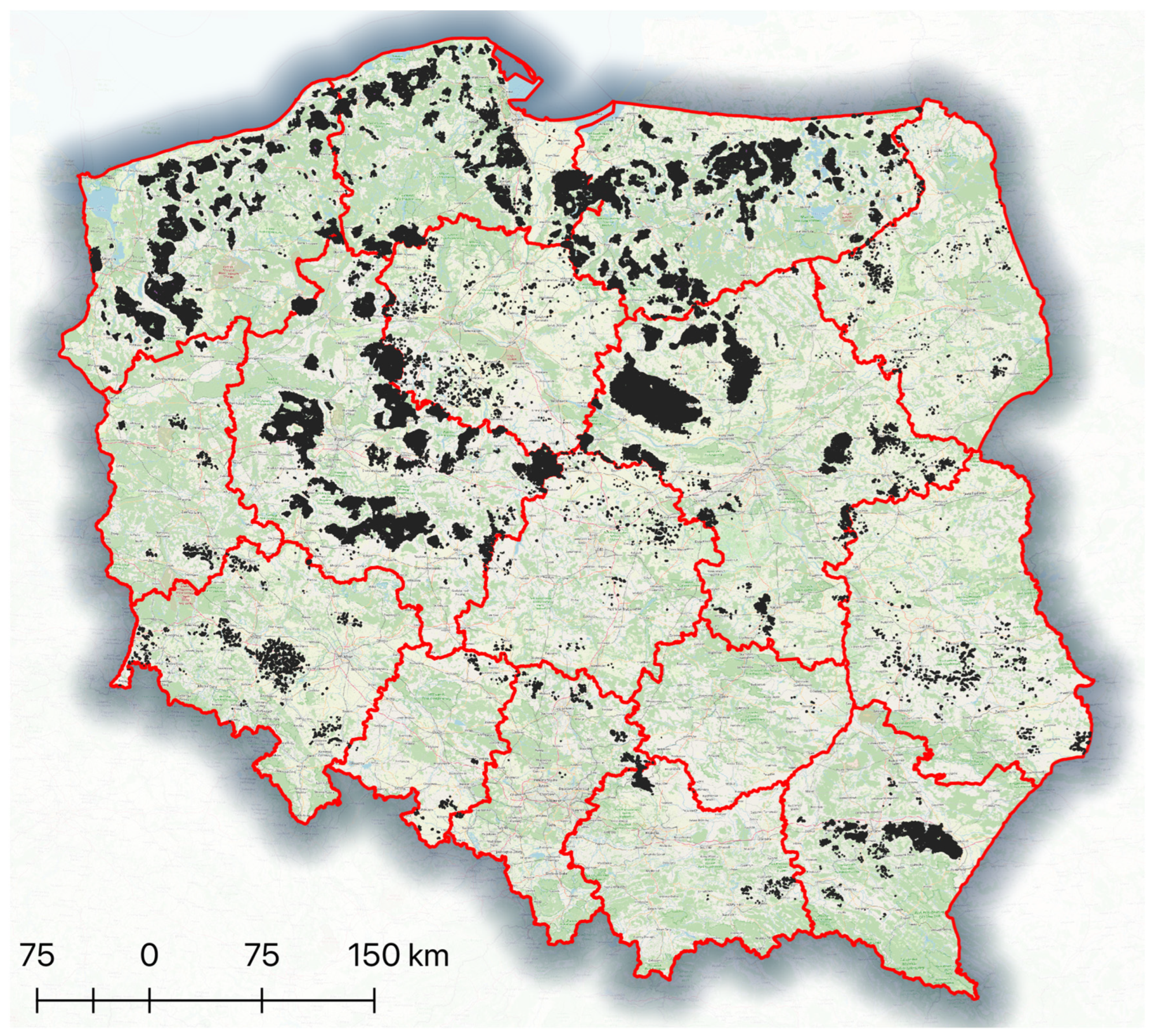
Implementing the semiautomated spatial analysis method allowed for the creation of a map of valuable areas for constructing wind farms in Poland (Figure 8). On a territory of Poland with an area of 322,575 km2 for 16 voivodeships, maps of suitable areas were created and then combined into one map. The time of each map creation differs due to the different densities of Bdot10k database objects per unit area of the voivodeship and the voivodeship area itself. Thus, applying the algorithm on the Podlaskie and Lower Silesian voivodeships, the algorithm execution time took two hours. These regions have relatively low data density per unit area. On the other hand, the map creation for Masovian, Pomeranian, and Lesser Poland voivodeships lasted from 4 to 6 h, which indicates a high data density per unit area of the regions (Pomeranian and Lesser Poland voivodeships), as well as a high data density combined with the size of the voivodeship itself (Masovian). Despite the large area of the Greater Poland voivodeship (the second largest in the country), the algorithm took two hours due to low data density.
The distribution of valuable areas is unequal across the country due to various factors. For example, all southern regions, except Subcarpathian, have low potential for wind energy development (Table 4). It is primarily due to the mountainous terrain, which reduces wind speed and air density. Hilly terrain was also excluded due to the relatively high land surface slope. Due to the widely represented nature protection network, Lublin, Lubusz, Podlaskie, and Holy Cross voivodeships have low potential for wind energy development (Table 4). Łódź and Kuyavian–Pomeranian voivodeships do not have considerable potential for wind energy development because they have a relatively small area with a high percentage of urbanisation. The five voivodeships with the most significant number of potential areas in Poland are Pomeranian, Warmian–Masurian, Masovian, Western Pomeranian and Greater Poland, with valuable areas of 909.74 km2, 1264.68 km2, 1305.67 km2, 1343.48 km2, and 1961.70 km2, respectively (Table 4). The territory’s total area with a high potential for wind farm construction is 7555.91 km2.
The selected area of 7555.91 km2 (about 2.34% of the country’s area) offers enormous opportunities for investors in renewable energy and choosing new sites that fit their strategy in the market. Based on the authors’ own research, the 2585 turbines in Poland produce 5818 MW, which is 71.38% of the total wind power capacity in the country for 2022 (8150 MW) [90]. Spread across 460.7 km2, these wind farms leverage a 250 m buffer around each turbine to maximise power generation. Adding 7555.91 km2 of selected areas could theoretically increase power capacity by 11.7 times to 103.55 GW if wind turbines were built throughout this area. This assumption is based on averaged data on built wind farms in the country and should be refined at further stages of assessing the potential of the selected area for wind farms. The most commonly used wind turbine model in Poland is the Vestas V90, which has a capacity of 2 MW (1206 pieces). Achieving the European Union’s target of 42.5% renewable energy production by 2030 may be achievable if the government persists in enhancing the investment climate in the country along with the liberalisation of laws governing the construction of renewable energy sources.

4. Discussion

Numerous scientific papers are using GIS and MCDM [26,29,91,92,93,94,95]. However, so far, no method has been analysed using a hybrid model, which involves a computational algorithm based on a set of 32 attributes (criteria) for the location of wind farms across the entire country. The authors of numerous papers have analysed different aspects with the help of GIS and MCDM, such as hybrid wind-solar systems in Aydin, Usak, Burdur, Denizli, and Mugla provinces in Turkey using 19 criteria [29], the appropriate sites for wind farms in part of the Western Macedonia prefecture in Greece using 10 criteria [91], and a possibility of establishing wind farms in the Ardabil province in Iran using 10 criteria [92]. On Polish territory in the Wrocław agglomeration, authors have presented a support framework to compare specific locations for wind farms using 13 criteria [93]. Wind, solar, biomass, geothermal, and hydropower energy potential were studied in the Fukushima region in Japan using eight criteria [94]. In the Liaodong Peninsula, China, authors have shown wind farm site selection using six criteria [95], as in the Drama prefecture, Greece, using eight criteria [96], and also in Oman using eight criteria [97]. Despite this, no one has so far used in the spatial analysis 10 attributes of conservation form (Table 3), 15 attributes of object data from the Bdot10k database, 4 attributes taking into account technical parameters—wind speed, air density, land surface roughness, and slope, and 3 additional attributes, such as ecological corridors, the flooding areas, and already built wind farms in the country.
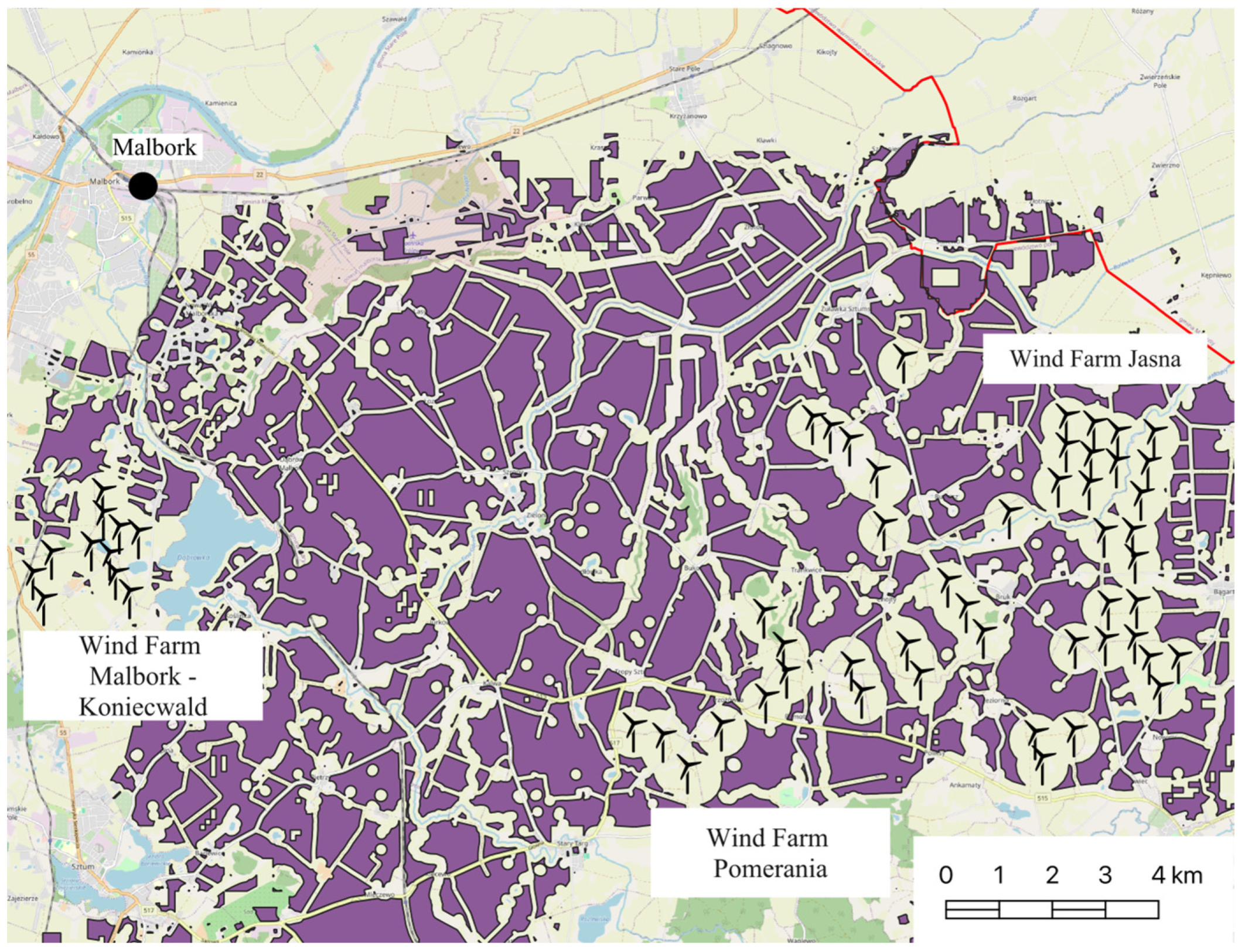
Through leveraging the spatial analysis functionalities of GIS with the structured decision-making framework, this study enables a holistic assessment of candidate wind farm sites [98]. This approach incorporates a broad spectrum of criteria [8,24], including wind resource potential [99], land availability [100], environmental sensitivities [101], grid integration, and others [102,103], allowing for informed and spatially grounded decision-making. Creating a mathematical model and applying an algorithm to perform the spatial analysis provides a quick response to changing business conditions [104], making necessary adjustments to the model and algorithm, getting results and saving money [14]. It, in turn, will make RES more competitive in the energy market, growing the industry [105,106]. Considering all these factors, the study provides valuable insights for spatial energy planning and efficient construction of onshore wind farms [8]. In favour of this approach, there is a substantial overlap between the selected areas and already constructed wind farms (Figure 9). For example, three wind farms have been built near Malbork (Pomeranian voivodeship), two of which, Pomerania [107] and Jasna [108], are among the largest in the country. The expense of constructing a wind farm can amount to hundreds of millions of dollars, where the price of error is very high. For this, the expansion of already built wind farms can be a safe solution for further business development [109].
Although this study offers valuable insights, it is crucial to acknowledge its constraints. For example, economic considerations, such as the cost of building and maintaining wind farms [110,111] and social factors, such as visual impact and community acceptance [112,113], could be helpful for future models. The need for constant updating of input data could affect the final result. For example, at the time of data collection and analysis (April 2023), the selected area was available for RES development. Still, when the necessary parameters are checked on the ground, it may turn out that the area is used for other purposes [114]. This means that during the project preparation process, the location of interest to the investor may be intended for the construction of another wind farm or other types of investments, such as the construction of a factory or a residential area. Also, due to the complexity of calculations and the large amount of data, it is only possible to consider some existing types of objects from the Bdot10k database. Thus, the analysis did not include objects like military bases and airports. For this purpose, it is necessary to consider this fact to avoid errors when working with the final map [30,91,115]. It is worth noting that wind energy regulations [68] and policies [20] can change over time, potentially affecting the permitting of wind farm projects. This study assumes compliance with current laws and policies, but future changes may affect future projects. The identified potential wind farm area offers a substantial leap towards Poland’s 2040 renewable energy production target [116,117]. Its development could aid in achieving energy independence [118], reducing dependence on non-renewable resources [119], and mitigating the effects of climate change [120]. By utilising existing infrastructure in areas with established wind farms, the study highlights a cost-effective approach for investors and developers. It can attract further investment, stimulate economic growth, and create jobs in the energy sector [121,122]. The methodology presented provides a replicable framework for informed spatial planning decisions. It can assist policymakers in identifying suitable areas for wind farms while considering environmental, social, and economic factors [123]. Future research could use advanced modelling techniques such as machine learning and AI algorithms to enhance site selection for wind energy projects, utilising historical data and real-time inputs [124]. Comparative studies across various regions or countries can offer beneficial insights into optimal wind farm site selection practices [125]. As climate change continues to impact wind patterns [126], future research must consider the long-term viability of wind energy projects by incorporating climate projections into site selection models and implementing resilient infrastructure [127].

5. Conclusions

This article showcases the efficacy of semiautomated spatial and multi-criteria analyses as tools for localising wind farms, providing valuable insights for decision-making in wind energy investments in Poland. These findings serve as a step for further research and development in the realm of renewable energy planning and implementation across the globe. The main points to extract from this article can be outlined as follows:
  • The selection of 7555.91 km2 (2.34% of Poland) as potential wind farm areas.
  • The proposed method provides a comprehensive and empirical data-driven approach to wind farm site selection, considering economic, social, and environmental factors.
  • The identified potential areas offer the possibility of increasing Poland’s wind power capacity by over 11 times, contributing to national and EU renewable energy targets.
  • The proposed method has been validated for practical applications through the spatial overlap observed between potential areas and existing wind farms.
  • Valuable insights for policymakers and decision-makers in spatial energy planning and wind farm development.
  • A replicable and adaptable methodology for other regions and renewable energy project types.
  • A foundation for further research on optimising wind farm placement and maximising renewable energy potential.

Author Contributions

Conceptualisation, A.A.; methodology, A.A. and G.Ł.; software, A.A.; validation, A.A. and G.Ł.; formal analysis, A.A.; investigation, A.A.; resources, A.A. and G.Ł.; data, A.A.; writing—original draft preparation, A.A.; writing—review and editing, A.A. and G.Ł.; visualisation, A.A.; project administration, G.Ł. All authors have read and agreed to the published version of the manuscript.

Funding

This research was funded by the Ministry of Education and Science of Poland, grant numbers WZ/WB-IIS/4/2023 and WI/WB-IIŚ/3/2024.

Data Availability Statement

Dataset available upon request from the authors.

Conflicts of Interest

The authors declare no conflicts of interest.

References

  1. Ari, A.; Arregui, N.; Black, S.; Celasun, O.; Iakova, D.M.; Mineshima, A.; Mylonas, V.; Parry, I.W.H.; Teodoru, I.; Zhunussova, K. Surging Energy Prices in Europe in the Aftermath of the War: How to Support the Vulnerable and Speed up the Transition Away from Fossil Fuels; IMF Working Papers; Volume 2022, International Monetary Fund: Washington, DC, USA, 2022. [Google Scholar]
  2. Eurostat. Electricity Prices for Household Consumers. Available online: https://ec.europa.eu/eurostat/databrowser/view/nrg_pc_204/default/map?lang=en (accessed on 16 January 2024).
  3. European Commission. The EU Aims to Be Climate-Neutral by 2050. Available online: https://climate.ec.europa.eu/eu-action/climate-strategies-targets/2050-long-term-strategy_en (accessed on 16 January 2024).
  4. Garegnani, G.; Sacchelli, S.; Balest, J.; Zambelli, P. GIS-Based Approach for Assessing the Energy Potential and the Financial Feasibility of Run-off-River Hydro-Power in Alpine Valleys. Appl. Energy 2018, 216, 709–723. [Google Scholar] [CrossRef]
  5. Laks, I.; Walczak, Z.; Walczak, N. Fuzzy Analytical Hierarchy Process Methods in Changing the Damming Level of a Small Hydropower Plant: Case Study of Rosko SHP in Poland. Water Resour. Ind. 2023, 29, 100204. [Google Scholar] [CrossRef]
  6. Tercan, E.; Eymen, A.; Urfalı, T.; Saracoglu, B.O. A Sustainable Framework for Spatial Planning of Photovoltaic Solar Farms Using GIS and Multi-Criteria Assessment Approach in Central Anatolia, Turkey. Land Use Policy 2021, 102, 105272. [Google Scholar] [CrossRef]
  7. Ahmadi, M.H.; Ghazvini, M.; Sadeghzadeh, M.; Alhuyi Nazari, M.; Kumar, R.; Naeimi, A.; Ming, T. Solar Power Technology for Electricity Generation: A Critical Review. Energy Sci. Eng. 2018, 6, 340–361. [Google Scholar] [CrossRef]
  8. Amsharuk, A.; Łaska, G. The Approach to Finding Locations for Wind Farms Using GIS and MCDA: Case Study Based on Podlaskie Voivodeship, Poland. Energies 2023, 16, 7107. [Google Scholar] [CrossRef]
  9. Amsharuk, A.; Łaska, G. A Review: Existing Methods for Solving Spatial Planning Problems for Wind Turbines in Poland. Energies 2022, 15, 8957. [Google Scholar] [CrossRef]
  10. Ghazvini, M.; Sadeghzadeh, M.; Ahmadi, M.H.; Moosavi, S.; Pourfayaz, F. Geothermal Energy Use in Hydrogen Production: A Review. Int. J. Energy Res. 2019, 43, 7823–7851. [Google Scholar] [CrossRef]
  11. Sowizdzal, A. Geothermal Energy Resources in Poland—Overview of the Current State of Knowledge. Renew. Sustain. Energy Rev. 2018, 82, 4020–4027. [Google Scholar] [CrossRef]
  12. Ioannou, K.; Tsantopoulos, G.; Arabatzis, G.; Andreopoulou, Z.; Zafeiriou, E. A Spatial Decision Support System Framework for the Evaluation of Biomass Energy Production Locations: Case Study in the Regional Unit of Drama, Greece. Sustainability 2018, 10, 531. [Google Scholar] [CrossRef]
  13. Dzikuć, M.; Piwowar, A. Ecological and Economic Aspects of Electric Energy Production Using the Biomass Co-Firing Method: The Case of Poland. Renew. Sustain. Energy Rev. 2016, 55, 856–862. [Google Scholar] [CrossRef]
  14. Vasileiou, M.; Loukogeorgaki, E.; Vagiona, D.G. GIS-Based Multi-Criteria Decision Analysis for Site Selection of Hybrid Offshore Wind and Wave Energy Systems in Greece. Renew. Sustain. Energy Rev. 2017, 73, 745–757. [Google Scholar] [CrossRef]
  15. Henfridsson, U.; Neimane, V.; Strand, K.; Kapper, R.; Bernhoff, H.; Danielsson, O.; Leijon, M.; Sundberg, J.; Thorburn, K.; Ericsson, E.; et al. Wave Energy Potential in the Baltic Sea and the Danish Part of the North Sea, with Reflections on the Skagerrak. Renew. Energy 2007, 32, 2069–2084. [Google Scholar] [CrossRef]
  16. Statistics Explained. Renewable Energy Statistics. Available online: https://ec.europa.eu/eurostat/statistics-explained/index.php?title=Renewable_energy_statistics (accessed on 15 January 2024).
  17. WindEurope. Wind Energy in Europe: 2022 Statistics and the Outlook for 2023–2027. Available online: https://windeurope.org/intelligence-platform/product/wind-energy-in-europe-2022-statistics-and-the-outlook-for-2023-2027/ (accessed on 15 January 2024).
  18. SolarPower Europe. EU Market Outlook for Solar Power 2022–2026. Available online: https://www.solarpowereurope.org/insights/market-outlooks/eu-market-outlook-for-solar-power-2022-2026-2 (accessed on 16 January 2024).
  19. European Commission. Renewable Energy Targets. Available online: https://energy.ec.europa.eu/topics/renewable-energy/renewable-energy-directive-targets-and-rules/renewable-energy-targets_en (accessed on 16 January 2024).
  20. Ustawa z Dnia 9 Marca 2023 r. o Zmianie Ustawy o Inwestycjach w Zakresie Elektrowni Wiatrowych Oraz Niektórych Innych Ustaw. Available online: https://isap.sejm.gov.pl/isap.nsf/DocDetails.xsp?id=WDU20230000553 (accessed on 19 July 2023).
  21. OZE w 2023 Roku. Co Czeka Nas w Najbliższych Miesiącach? Available online: https://www.green-news.pl/3859-OZE-podsumowanie-2023-roku-prognozy-2024 (accessed on 16 January 2024).
  22. Gyamfi, B.A.; Adedoyin, F.F.; Bein, M.A.; Bekun, F.V.; Agozie, D.Q. The Anthropogenic Consequences of Energy Consumption in E7 Economies: Juxtaposing Roles of Renewable, Coal, Nuclear, Oil and Gas Energy: Evidence from Panel Quantile Method. J. Clean. Prod. 2021, 295, 126373. [Google Scholar] [CrossRef]
  23. Saidur, R.; Rahim, N.A.; Islam, M.R.; Solangi, K.H. Environmental Impact of Wind Energy. Renew. Sustain. Energy Rev. 2011, 15, 2423–2430. [Google Scholar] [CrossRef]
  24. Szurek, M.; Blachowski, J.; Nowacka, A. GIS-Based Method for Wind Farm Location Multi-Criteria Analysis. Min. Sci. 2014, 21, 65–81. [Google Scholar] [CrossRef]
  25. Tsoutsos, T.; Tsitoura, I.; Kokologos, D.; Kalaitzakis, K. Sustainable Siting Process in Large Wind Farms Case Study in Crete. Renew. Energy 2015, 75, 474–480. [Google Scholar] [CrossRef]
  26. Sotiropoulou, K.F.; Vavatsikos, A.P. Onshore Wind Farms GIS-Assisted Suitability Analysis Using PROMETHEE II. Energy Policy 2021, 158, 112531. [Google Scholar] [CrossRef]
  27. Villacreses, G.; Gaona, G.; Martínez-Gómez, J.; Jijón, D.J. Wind Farms Suitability Location Using Geographical Information System (GIS), Based on Multi-Criteria Decision Making (MCDM) Methods: The Case of Continental Ecuador. Renew. Energy 2017, 109, 275–286. [Google Scholar] [CrossRef]
  28. Łaska, G. Wind Energy and Multicriteria Analysis in Making Decisions on the Location of Wind Farms: A Case Study in the North-Eastern of Poland. In Modeling, Simulation and Optimization of Wind Farms and Hybrid Systems; Maalawi, K., Ed.; IntechOpen: London, UK, 2020; pp. 1–18. [Google Scholar]
  29. Aydin, N.Y.; Kentel, E.; Sebnem Duzgun, H. GIS-Based Site Selection Methodology for Hybrid Renewable Energy Systems: A Case Study from Western Turkey. Energy Convers. Manag. 2013, 70, 90–106. [Google Scholar] [CrossRef]
  30. Sliz-Szkliniarz, B.; Vogt, J. GIS-Based Approach for the Evaluation of Wind Energy Potential: A Case Study for the Kujawsko–Pomorskie Voivodeship. Renew. Sustain. Energy Rev. 2011, 15, 1696–1707. [Google Scholar] [CrossRef]
  31. Ayodele, T.R.; Ogunjuyigbe, A.S.O.; Odigie, O.; Munda, J.L. A Multi-Criteria GIS Based Model for Wind Farm Site Selection Using Interval Type-2 Fuzzy Analytic Hierarchy Process: The Case Study of Nigeria. Appl. Energy 2018, 228, 1853–1869. [Google Scholar] [CrossRef]
  32. Saraswat, S.K.; Digalwar, A.K.; Yadav, S.S.; Kumar, G. MCDM and GIS Based Modelling Technique for Assessment of Solar and Wind Farm Locations in India. Renew. Energy 2021, 169, 865–884. [Google Scholar] [CrossRef]
  33. Waewsak, J.; Ali, S.; Natee, W.; Kongruang, C.; Chancham, C.; Gagnon, Y. Assessment of Hybrid, Firm Renewable Energy-Based Power Plants: Application in the Southernmost Region of Thailand. Renew. Sustain. Energy Rev. 2020, 130, 109953. [Google Scholar] [CrossRef]
  34. Elkadeem, M.R.; Younes, A.; Sharshir, S.W.; Campana, P.E.; Wang, S. Sustainable Siting and Design Optimization of Hybrid Renewable Energy System: A Geospatial Multi-Criteria Analysis. Appl. Energy 2021, 295, 117071. [Google Scholar] [CrossRef]
  35. Kobryń, A. Wielokryterialne Wspomaganie Decyzji w Gospodarowaniu Przestrzenią; Difin: Warszawa, Poland, 2014; ISBN 9788379304691. [Google Scholar]
  36. Trzaskalik, T. Multiple Criteria Decision Making’05; The Karol Adamiecki University of Economics: Katowice, Poland, 2006; ISBN 8372468435. [Google Scholar]
  37. Goodwin, P.; Wright, G. Analiza Decyzji; Wydawnictwo Nieoczywiste: Siedliska, Poland, 2016; ISBN 9788363391065. [Google Scholar]
  38. Saaty, T.L. The Analytic Hierarchy Process: Planning, Priority Setting, Resource Allocation; McGraw-Hill: New York, NY, USA, 1980; Volume 9, ISBN 9780070543713. [Google Scholar]
  39. Saaty, T.L. The Analytic Hierarchy Process; Golden, B.L., Wasil, E.A., Harker, P.T., Eds.; Springer: Berlin/Heidelberg, Germany, 1989; ISBN 978-3-642-50246-0. [Google Scholar]
  40. Erdamar, B.; Luis Garcia-Lapresta, J.; Pérez-Roman, D. Measuring Consensus in a Preference-Approval Context. Inf. Fusion. 2012, 17, 2012–2023. [Google Scholar] [CrossRef]
  41. Bouyssou, D.; Marchant, T.; Pirlot, M.; Tsoukiàs, A.; Vincke, P. Evaluation and Decision Models with Multiple Criteria, 1st ed.; Springer: New York, NY, USA, 2006; Volume 86. [Google Scholar]
  42. Hwang, C.-L.; Yoon, K. Multiple Attribute Decision Making, 1st ed.; Lecture Notes in Economics and Mathematical Systems; Springer: Berlin, Germany, 1981; Volume 186, ISBN 978-3-540-10558-9. [Google Scholar]
  43. Hwang, C.L.; Lai, Y.J.; Liu, T.Y. A New Approach for Multiple Objective Decision Making. Comput. Oper. Res. 1993, 20, 889–899. [Google Scholar] [CrossRef]
  44. Basic Information about Poland—Civil Service—Portal Gov.Pl. Available online: https://www.gov.pl/web/civilservice/basic-information-about-poland (accessed on 21 May 2024).
  45. Geography of Poland: Landscape, Climate, Nature & Economy. Available online: https://www.intopoland.com/poland-info/geography-of-poland.html (accessed on 21 May 2024).
  46. Climate. Study.Gov.Pl. Available online: https://study.gov.pl/climate (accessed on 21 May 2024).
  47. Poland—Climatology. Climate Change Knowledge Portal. Available online: https://climateknowledgeportal.worldbank.org/country/poland/climate-data-historical (accessed on 21 May 2024).
  48. Parki Narodowe—Polskie Parki Narodowe. Available online: https://zpppn.pl/parki-narodowe (accessed on 23 May 2024).
  49. General Directorate for Environmental Protection. Forms of Nature Protection. Available online: http://www.gdos.gov.pl/forms-of-nature-protection (accessed on 23 May 2024).
  50. Białowieża National Park. Available online: https://bpn.com.pl/index.php?option=com_content&task=view&id=104&Itemid=178 (accessed on 21 May 2024).
  51. Tatra National Park. Available online: https://tpn.gov.pl/tatra-national-park (accessed on 21 May 2024).
  52. Biebrza National Park. Available online: https://bbpn.gov.pl/biebrza-national-park (accessed on 21 May 2024).
  53. “Ujście Warty” National Park. Available online: https://pnuw.gov.pl/ujscie-warty-national-park (accessed on 21 May 2024).
  54. Report on the Survey of Environmental Awareness and Behavior of Polish Residents. Available online: https://www.gov.pl/web/edukacja-ekologiczna/badania2 (accessed on 21 May 2024).
  55. Poland—Environmental Technologies. Available online: https://www.trade.gov/country-commercial-guides/poland-environmental-technologies (accessed on 21 May 2024).
  56. Baza Danych Obiektów Topograficznych-BDOT10k. Available online: https://dane.gov.pl/pl/dataset/2030,dane-obiektow-topograficznych-o-szczegolowosci-zap (accessed on 28 June 2023).
  57. Topographic Objects Database (BDOT10k). Available online: https://www.geoportal.gov.pl/dane/baza-danych-obiektow-topograficznych-bdot (accessed on 28 June 2023).
  58. Geoportal.Gov.Pl. Available online: https://mapy.geoportal.gov.pl/imap/Imgp_2.html (accessed on 28 June 2023).
  59. Numeryczny Model Terenu o Interwale Siatki Co Najmniej 100 m. Available online: https://dane.gov.pl/pl/dataset/792,numeryczny-model-terenu-o-interwale-siatki-co-najmniej-100-m (accessed on 28 June 2023).
  60. Digital Elevation Model (DEM). Available online: https://www.geoportal.gov.pl/dane/numeryczny-model-terenu (accessed on 28 June 2023).
  61. Generalna Dyrekcja Ochrony Środowiska. Dostęp Do Danych Geoprzestrzennych. Available online: https://www.gov.pl/web/gdos/dostep-do-danych-geoprzestrzennych (accessed on 28 June 2023).
  62. METEO IMGW-PIB. Available online: https://meteo.imgw.pl/ (accessed on 28 June 2023).
  63. INSPIRE. Available online: https://isok.gov.pl/inspire.html (accessed on 28 June 2023).
  64. ESA/CCI Viewer. Available online: http://maps.elie.ucl.ac.be/CCI/viewer/download.php (accessed on 29 June 2023).
  65. Floors, R.; Badger, M.; Troen, I.; Grogan, K.; Permien, F.H. Satellite-Based Estimation of Roughness Lengths and Displacement Heights for Wind Resource Modelling. Wind. Energy Sci. 2021, 6, 1379–1400. [Google Scholar] [CrossRef]
  66. Global Wind Atlas. Available online: https://globalwindatlas.info/en/ (accessed on 1 July 2023).
  67. Poland Wind Power Plants. Available online: https://openinframap.org/stats/area/Poland/plants?source=wind (accessed on 29 June 2023).
  68. Dziennik Ustaw—Rok 2023 Poz. 1336—INFOR.PL. Available online: https://www.infor.pl/akt-prawny/DZU.2023.194.0001336,ustawa-o-ochronie-przyrody.html (accessed on 1 March 2024).
  69. Kiker, G.A.; Bridges, T.S.; Varghese, A.; Seager, P.T.P.; Linkov, I. Application of Multicriteria Decision Analysis in Environmental Decision Making. Integr. Environ. Assess. Manag. 2005, 1, 95–108. [Google Scholar] [CrossRef] [PubMed]
  70. Huang, I.B.; Keisler, J.; Linkov, I. Multi-Criteria Decision Analysis in Environmental Sciences: Ten Years of Applications and Trends. Sci. Total Environ. 2011, 409, 3578–3594. [Google Scholar] [CrossRef]
  71. Skibniewski, M.J.; Chao, L. Evaluation of Advanced Construction Technology with AHP Method. J. Constr. Eng. Manag. 1992, 118, 577–593. [Google Scholar] [CrossRef]
  72. Lin, Z.C.; Yang, C.B. Evaluation of Machine Selection by the AHP Method. J. Mater. Process Technol. 1996, 57, 253–258. [Google Scholar] [CrossRef]
  73. Gaudenzi, B.; Borghesi, A. Managing Risks in the Supply Chain Using the AHP Method. Int. J. Logist. Manag. 2006, 17, 114–136. [Google Scholar] [CrossRef]
  74. Saaty, T.L.; Vargas, L.G. Models, Methods, Concepts & Applications of the Analytic Hierarchy Process; International Series in Operations Research & Management Science; Springer: Boston, MA, USA, 2001; Volume 34, ISBN 978-1-4613-5667-7. [Google Scholar]
  75. Taylan, O.; Bafail, A.O.; Abdulaal, R.M.S.; Kabli, M.R. Construction Projects Selection and Risk Assessment by Fuzzy AHP and Fuzzy TOPSIS Methodologies. Appl. Soft Comput. 2014, 17, 105–116. [Google Scholar] [CrossRef]
  76. Amiri, M.P. Project Selection for Oil-Fields Development by Using the AHP and Fuzzy TOPSIS Methods. Expert. Syst. Appl. 2010, 37, 6218–6224. [Google Scholar] [CrossRef]
  77. Chatterjee, P.; Stević, Ž. A Two-Phase Fuzzy AHP—Fuzzy TOPSIS Model for Supplier Evaluation in Manufacturing Environment. Oper. Res. Eng. Sci. Theory Appl. 2019, 2, 72–90. [Google Scholar] [CrossRef]
  78. Lima-Junior, F.R.; Carpinetti, L.C.R. Combining SCOR® Model and Fuzzy TOPSIS for Supplier Evaluation and Management. Int. J. Prod. Econ. 2016, 174, 128–141. [Google Scholar] [CrossRef]
  79. Shidpour, H.; Shahrokhi, M.; Bernard, A. A Multi-Objective Programming Approach, Integrated into the TOPSIS Method, in Order to Optimize Product Design; in Three-Dimensional Concurrent Engineering. Comput. Ind. Eng. 2013, 64, 875–885. [Google Scholar] [CrossRef]
  80. Lin, M.C.; Wang, C.C.; Chen, M.S.; Chang, C.A. Using AHP and TOPSIS Approaches in Customer-Driven Product Design Process. Comput. Ind. 2008, 59, 17–31. [Google Scholar] [CrossRef]
  81. Vavrek, R.; Chovancová, J. Assessment of Economic and Environmental Energy Performance of EU Countries Using CV-TOPSIS Technique. Ecol. Indic. 2019, 106, 105519. [Google Scholar] [CrossRef]
  82. Behzadian, M.; Khanmohammadi Otaghsara, S.; Yazdani, M.; Ignatius, J. A State-of the-Art Survey of TOPSIS Applications. Expert Syst. Appl. 2012, 39, 13051–13069. [Google Scholar] [CrossRef]
  83. Ansari, M.T.J.; Al-Zahrani, F.A.; Pandey, D.; Agrawal, A. A Fuzzy TOPSIS Based Analysis toward Selection of Effective Security Requirements Engineering Approach for Trustworthy Healthcare Software Development. BMC Med. Inform. Decis. Mak. 2020, 20, 236. [Google Scholar] [CrossRef]
  84. Büyüközkan, G.; Çifçi, G. A Combined Fuzzy AHP and Fuzzy TOPSIS Based Strategic Analysis of Electronic Service Quality in Healthcare Industry. Expert Syst. Appl. 2012, 39, 2341–2354. [Google Scholar] [CrossRef]
  85. Mericskay, B. Automation of Workflows for the Installation of a Wind Farm. QGIS Appl. Territ. Plan. 2018, 3, 125–168. [Google Scholar] [CrossRef]
  86. The Graphical Modeler in QGiS. Available online: https://docs.qgis.org/2.18/en/docs/user_manual/processing/modeler.html (accessed on 8 February 2024).
  87. Badora, K. Farmy Wiatrowe Jako Elementy Determinujące Strukturę i Funkcjonowanie Krajobrazu Wiejskiego. Archit. Kraj. 2013, 2, 58–77. [Google Scholar]
  88. Nõ Lvak, H.; Truu, J.; Limane, B.; Truu, M.; Cepurnieks, G.; Bartkevičs, V.; Juhanson, J.; Muter, O. Visual Impact Assessment of Wind Turbines and Their Farms on Landscape of Kretinga Region (Lithuania) and Grobina Townscape (Latvia). J. Environ. Eng. Landsc. Manag. 2015, 23, 39–49. [Google Scholar] [CrossRef]
  89. Resak, M.; Rogosz, B.; Szczepiński, J.; Dziamara, M. Legal Conditions for Investments in Renewable Energy in the Overburden Disposal Areas in Poland. Sustainability 2022, 14, 1065. [Google Scholar] [CrossRef]
  90. Główny Urząd Statystyczny. Zużycie Energii w Gospodarstwach Domowych w 2022 Roku. Available online: https://stat.gov.pl/obszary-tematyczne/srodowisko-energia/energia/energia-ze-zrodel-odnawialnych-w-2022-roku,3,17.html (accessed on 12 February 2024).
  91. Latinopoulos, D.; Kechagia, K. A GIS-Based Multi-Criteria Evaluation for Wind Farm Site Selection. A Regional Scale Application in Greece. Renew. Energy 2015, 78, 550–560. [Google Scholar] [CrossRef]
  92. Azizi, A.; Malekmohammadi, B.; Jafari, H.R.; Nasiri, H.; Amini Parsa, V. Land Suitability Assessment for Wind Power Plant Site Selection Using ANP-DEMATEL in a GIS Environment: Case Study of Ardabil Province, Iran. Environ. Monit. Assess. 2014, 186, 6695–6709. [Google Scholar] [CrossRef] [PubMed]
  93. Kazak, J.; van Hoof, J.; Szewranski, S. Challenges in the Wind Turbines Location Process in Central Europe—The Use of Spatial Decision Support Systems. Renew. Sustain. Energy Rev. 2017, 76, 425–433. [Google Scholar] [CrossRef]
  94. Wang, Q.; M’Ikiugu, M.M.; Kinoshita, I. A GIS-Based Approach in Support of Spatial Planning for Renewable Energy: A Case Study of Fukushima, Japan. Sustainability 2014, 6, 2087–2117. [Google Scholar] [CrossRef]
  95. Li, M.; Xu, Y.; Guo, J.; Li, Y.; Li, W. Application of a GIS-Based Fuzzy Multi-Criteria Evaluation Approach for Wind Farm Site Selection in China. Energies 2020, 13, 2426. [Google Scholar] [CrossRef]
  96. Konstantinos, I.; Georgios, T.; Garyfalos, A. A Decision Support System Methodology for Selecting Wind Farm Installation Locations Using AHP and TOPSIS: Case Study in Eastern Macedonia and Thrace Region, Greece. Energy Policy 2019, 132, 232–246. [Google Scholar] [CrossRef]
  97. Al-Yahyai, S.; Charabi, Y.; Gastli, A.; Al-Badi, A. Wind Farm Land Suitability Indexing Using Multi-Criteria Analysis. Renew. Energy 2012, 44, 80–87. [Google Scholar] [CrossRef]
  98. Kaya, T.; Kahraman, C. Multicriteria Decision Making in Energy Planning Using a Modified Fuzzy TOPSIS Methodology. Expert Syst. Appl. 2011, 38, 6577–6585. [Google Scholar] [CrossRef]
  99. Díaz-Cuevas, P.; Biberacher, M.; Domínguez-Bravo, J.; Schardinger, I. Developing a Wind Energy Potential Map on a Regional Scale Using GIS and Multi-Criteria Decision Methods: The Case of Cadiz (South of Spain). Clean. Technol. Environ. Policy 2018, 20, 1167–1183. [Google Scholar] [CrossRef]
  100. Nitsch, F.; Turkovska, O.; Schmidt, J. Observation-Based Estimates of Land Availability for Wind Power: A Case Study for Czechia. Energy Sustain. Soc. 2019, 9, 45. [Google Scholar] [CrossRef]
  101. Łaska, G. Wind Energy and Multi-Criteria Analysis in Making Decisions on the Location of Wind Farms. Procedia Eng. 2017, 182, 418–424. [Google Scholar] [CrossRef]
  102. Baban, S.M.J.; Parry, T. Developing and Applying a GIS-Assisted Approach to Locating Wind Farms in the UK. Renew. Energy 2001, 24, 59–71. [Google Scholar] [CrossRef]
  103. Chamanehpour, E. Site Selection of Wind. Power Plant Using. Multi-Criteria Decision-Making Methods in GIS: A Case Study. Comput. Ecol. Softw. 2017; 7, 49. [Google Scholar] [CrossRef]
  104. AFRY. Wind of Change: A Guide to Improve Your Wind Farm’s Profitability. Available online: https://afry.com/en/insight/wind-change-guide-improve-your-wind-farms-profitability (accessed on 5 March 2024).
  105. Immediate Actions for the European Wind Power Industry. Available online: https://ec.europa.eu/commission/presscorner/detail/en/ip_23_5185 (accessed on 5 March 2024).
  106. LinkedIn. The Wind Farm Industry: A Decade of Growth and Global Opportunities. Available online: https://www.linkedin.com/pulse/wind-farm-industry-decade-growth-global-opportunities/ (accessed on 5 March 2024).
  107. Ignitis Polska • Ignitis Polska Sp. z o.o. Available online: https://ignitis.pl/ignitis-polska/ (accessed on 13 February 2024).
  108. Polish Wind Farm “Jasna” with 132 MW Completed. Available online: https://www.sevivon.pl/aktualnosci/detail/polish-wind-farm-jasna-with-132-mw-completed/ (accessed on 13 February 2024).
  109. Abdulrahman, M.; Wood, D. Wind Farm Layout Upgrade Optimization. Energies 2019, 12, 2465. [Google Scholar] [CrossRef]
  110. Rehman, S.; Mohammed, A.B.; Alhems, L. A Heuristic Approach to Siting and Design Optimization of an Onshore Wind Farm Layout. Energies 2020, 13, 5946. [Google Scholar] [CrossRef]
  111. Kuczyński, W.; Wolniewicz, K.; Charun, H. Analysis of the Wind Turbine Selection for the Given Wind Conditions. Energies 2021, 14, 7740. [Google Scholar] [CrossRef]
  112. Gross, C. Community Perspectives of Wind Energy in Australia: The Application of a Justice and Community Fairness Framework to Increase Social Acceptance. Energy Policy 2007, 35, 2727–2736. [Google Scholar] [CrossRef]
  113. Hall, N.; Ashworth, P.; Devine-Wright, P. Societal Acceptance of Wind Farms: Analysis of Four Common Themes across Australian Case Studies. Energy Policy 2013, 58, 200–208. [Google Scholar] [CrossRef]
  114. Celik, A.N. Optimisation and Techno-Economic Analysis of Autonomous Photovoltaic-Wind Hybrid Energy Systems in Comparison to Single Photovoltaic and Wind Systems. Energy Convers. Manag. 2002, 43, 2453–2468. [Google Scholar] [CrossRef]
  115. Díaz-Cuevas, P.; Domínguez-Bravo, J.; Prieto-Campos, A. Integrating MCDM and GIS for Renewable Energy Spatial Models: Assessing the Individual and Combined Potential for Wind, Solar and Biomass Energy in Southern Spain. Clean. Technol. Environ. Policy 2019, 21, 1855–1869. [Google Scholar] [CrossRef]
  116. Ministry of Climate and Environment—Gov.Pl Website. Energy Policy of Poland Until 2040 (EPP2040). Available online: https://www.gov.pl/web/climate/energy-policy-of-poland-until-2040-epp2040 (accessed on 5 March 2024).
  117. Poland|Electricity Transition|Ember. Available online: https://ember-climate.org/countries-and-regions/countries/poland/ (accessed on 5 March 2024).
  118. Moving towards Energy Independence Wind Energy and Community Resilience. Available online: https://energy5.com/moving-towards-energy-independence-wind-energy-and-community-resilience (accessed on 5 March 2024).
  119. WindCycle. Blowing Away Fossil Fuels: The Impact of Wind Turbines on Energy Production. Available online: https://windcycle.energy/blowing-away-fossil-fuels/ (accessed on 5 March 2024).
  120. Zhang, D.; Xu, Z.; Li, C.; Yang, R.; Shahidehpour, M.; Wu, Q.; Yan, M. Economic and Sustainability Promises of Wind Energy Considering the Impacts of Climate Change and Vulnerabilities to Extreme Conditions. Electr. J. 2019, 32, 7–12. [Google Scholar] [CrossRef]
  121. NREL. News. Growth in Offshore Wind Energy Offers Huge Opportunity to Create U.S. Jobs. Available online: https://www.nrel.gov/news/program/2022/growth-in-offshore-wind-energy-offers-huge-opportunity-to-create-us-jobs.html (accessed on 5 March 2024).
  122. New Floating Wind Farm Will Power 4 Million Homes And Create Jobs. Available online: https://www.preciseconsultants.com/news/new-floating-wind-farm-will-power-4-million-homes-and-create-jobs/42274/ (accessed on 5 March 2024).
  123. Can Şener, Ş.E.; Anctil, A.; Sharp, J.L. Economic and Environmental Factors of Wind Energy Deployment in the United States. Renew. Energy Focus 2023, 45, 150–168. [Google Scholar] [CrossRef]
  124. Liu, Y.; Wang, Y.; Wang, Q.; Zhang, K.; Qiang, W.; Wen, Q.H. Recent Advances in Data-Driven Prediction for Wind Power. Front. Energy Res. 2023, 11, 1204343. [Google Scholar] [CrossRef]
  125. Gautam, A.; Warudkar, V.; Bhagoria, J.L. A Comparative Analysis of Wind Characteristics for Distinct Terrains of India. Sustain. Energy Technol. Assess. 2022, 52, 102089. [Google Scholar] [CrossRef]
  126. Pryor, S.C.; Barthelmie, R.J.; Bukovsky, M.S.; Leung, L.R.; Sakaguchi, K. Climate Change Impacts on Wind Power Generation. Nat. Rev. Earth Environ. 2020, 1, 627–643. [Google Scholar] [CrossRef]
  127. Zio, E.; Patil, R.B.; Kara, T.; Duran¸sahin, A.; Duran¸sahin, D. Implications of Climate Change on Wind Energy Potential. Sustainability 2023, 15, 14822. [Google Scholar] [CrossRef]
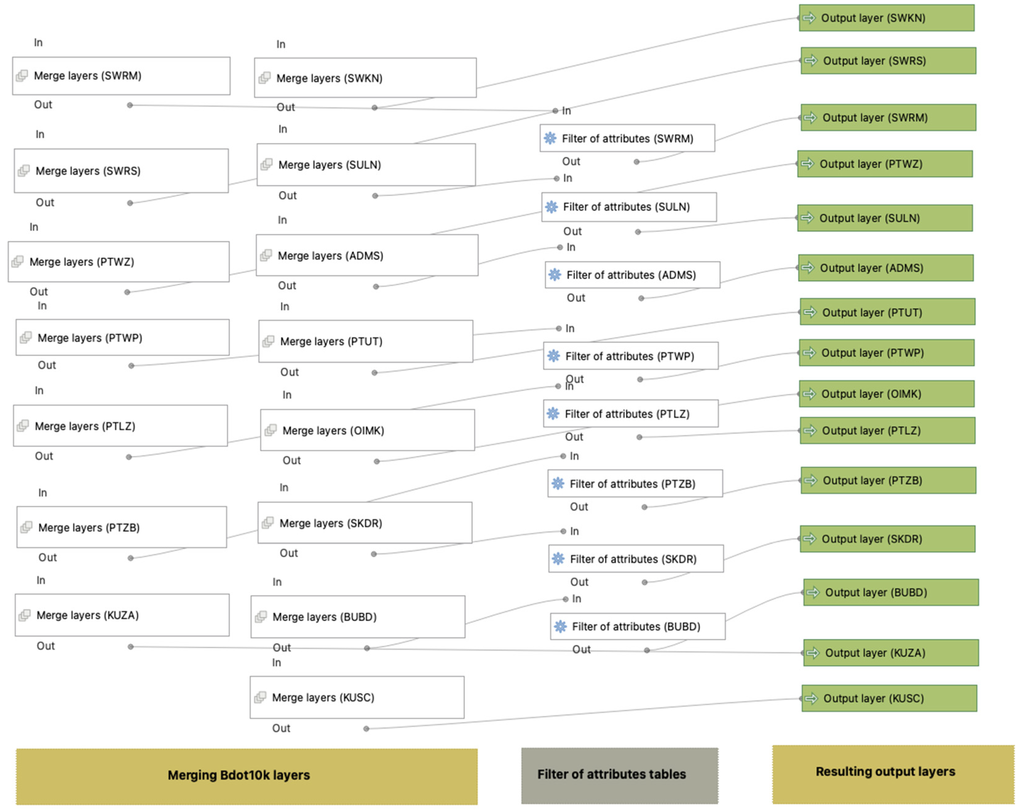
Figure 1. Merging Bdot10k layers with filtration of the attribute’s tables.
Energies 17 02635 g001
Figure 2. Creating buffer areas around each object from the Bdot10k database in the voivodeship scale.
Energies 17 02635 g002
Figure 3. Creating buffer zones around each form of nature protection in Poland on the state scale.
Energies 17 02635 g003
Figure 4. Creating a map of suitable areas according to ecological criteria.
Energies 17 02635 g004
Figure 5. Creating a map of suitable areas according to Bdot10k criteria.
Energies 17 02635 g005
Figure 6. Creating a resulting map of suitable areas for building wind farms in voivodeship.
Energies 17 02635 g006
Figure 7. Area earmarked for potential investments containing candidate locations for wind farms after spatial analysis (highlighted in black—chosen sites after exclusion) [8].
Energies 17 02635 g007
Figure 8. The resulting map of suitable areas for building wind farms in Poland (black colour—selected plots after spatial analysis, red colour—voivodeship’s boarders).
Energies 17 02635 g008
Figure 9. Already built wind farms near the city of Malbork (violet colour—selected plots after spatial analysis, red colour—voivodeship’s boarders, black dot—center of city Malbork).
Energies 17 02635 g009
Table 1. Data for GIS layers used in the analysis of potential wind farm locations.
GIS Layer NameDataData TypeSource
SWRSRivers and springsGeospatial vector
(Shp file)
[56]
SWKNChannels
SWRMDrainage ditches
OIMKWetlands
PTWPSurface water
PTZB—Urban areas
BUBDBuildings
SULNPower grid
SKDRRoads
PTLZForests
PTUTPermanent crops
KUSCSacral complexes
KUZAHistorical complexes
ADMSTerritorial divisions
PTWZExcavations and heaps
National parksNational parksGeospatial vector
(Shp file)
[61]
ReservesReserves
Natura 2000 network (SAC)Natura 2000 network (SAC)
Natura 2000 network (SPA)Natura 2000 network (SPA)
Landscape parksLandscape parks
Protected landscape areasProtected landscape areas
Natural landscape complexesNatural landscape complexes
Ecological sitesEcological sites
Monuments of natureMonuments of nature
Documentation postsDocumentation posts
ISOKFlood-risk areas[63]
LCCLLand cover classification[64]
DEMDigital Elevation ModelTag Image File Format
(Tiff file)
[60]
Wind speed 100mWind speed and at 100 m[66]
Air power densityAir power density at 100 m[66]
WindFarmLocations of currently built wind farmsGeospatial vector
(Shp file)
[67]
Table 2. Criteria and their values while mathematical modelling.
CriteriaCriteria Value
Protected nature areas, m2000
Protected monuments of nature, m200
Distance from urban areas, m700
Distance from power grid, m200
Distance from roads, m100
Distance from forests, m100
Distance from water network, m100
Slope, °0–3
Roughness class2
Mean wind speed, m/s8
Power density of air, W/m2500
Table 3. GIS layers with buffer zones used in spatial analysis.
GIS LayersBuffer, mGIS LayersBuffer, m
Protected nature areasWater network
Monuments of nature200Surface water100
Ecological sites200Rivers and streams100
Reserves500Channels100
Landscape parks0Collective drainage ditches100
National parks2000Swamps and wetlands100
Protected landscape areas200Flood hazard areas0
Natural landscape complexes200Permanent crops
Documentation posts200Permanent crops25
Natura 2000 (birds)2000Urban areas
Natura 2000 (habitats)2000Building700
Ecological corridors0Buildings700
ForestsPower grid
Forest100Power grid10
Areas around already-built
wind turbines
Roads
Areas around
wind turbines
500Roads50
Table 4. Names of voivodeships with suitable areas with a ratio to the total area.
Voivodeship
Name
Suitable
Area, km2
Share to the
Total Area, %
Total Selected
Area, km2
Lower Silesian158.882.107555.91
Kuyavian–Pomeranian108.421.43
Lublin81.221.07
Lubusz49.540.66
Łódź36.720.49
Lesser Poland35.270.47
Masovian1305.6717.28
Opole17.880.24
Subcarpathian193.812.57
Podlaskie33.130.44
Pomeranian909.7412.04
Silesian55.260.73
Holy Cross0.520.01
Warmian–Masurian1264.6816.74
Greater Poland1961.7025.96
Western Pomeranian1343.4817.78
Disclaimer/Publisher’s Note: The statements, opinions and data contained in all publications are solely those of the individual author(s) and contributor(s) and not of MDPI and/or the editor(s). MDPI and/or the editor(s) disclaim responsibility for any injury to people or property resulting from any ideas, methods, instructions or products referred to in the content.