Article

Sustainable Spatial Energy Planning of Large-Scale Wind and PV Farms in Israel: A Collaborative and Participatory Planning Approach

1
Department of Spatial Planning and Development, Faculty of Engineering, Aristotle University of Thessaloniki, 54124 Thessaloniki, Greece
2
Department of Civil Engineering, Faculty of Engineering, Aristotle University of Thessaloniki, 54124 Thessaloniki, Greece
3
SP Interface, Rehovot 7630804, Israel
*
Author to whom correspondence should be addressed.
Energies 2021, 14(3), 551; https://doi.org/10.3390/en14030551
Submission received: 28 December 2020 / Revised: 17 January 2021 / Accepted: 18 January 2021 / Published: 21 January 2021
(This article belongs to the Special Issue GIS and Remote Sensing for Renewable Energy Assessment and Maps)

Abstract

:
In this work, an innovative sustainable spatial energy planning framework is developed on national scale for identifying and prioritizing appropriate, technically and economically feasible, environmentally sustainable as well as socially acceptable sites for the siting of large-scale onshore Wind Farms (WFs) and Photovoltaic Farms (PVFs) in Israel. The proposed holistic framework consists of distinctive steps allocated in two successive modules (the Planning and the Field Investigation module), and it covers all relevant dimensions of a sustainable siting analysis (economic, social, and environmental). It advances a collaborative and participatory planning approach by combining spatial planning tools (Geographic Information Systems (GIS)) and multi-criteria decision-making methods (e.g., Analytical Hierarchy Process (AHP)) with versatile participatory planning techniques in order to consider the opinion of three different participatory groups (public, experts, and renewable energy planners) within the site-selection processes. Moreover, it facilitates verification of GIS results by conducting appropriate field observations. Sites of high suitability, accepted by all participatory groups and field verified, form the final outcome of the proposed framework. The results illustrate the existence of high suitable sites for large-scale WFs’ and PVFs’ siting and, thus, the potential deployment of such projects towards the fulfillment of the Israeli energy targets in the near future.

1. Introduction

Environmental concerns related to reduction in greenhouse gas emissions and mitigation of climate change effects have established Renewable Energy (RE) as a mainstream source of electricity generation globally. According to [1], by the end of 2019, the estimated share of renewables in global electricity generation was 27.3%, while the net additional installed capacity of RE Technologies (RETs) was higher compared to both fossil fuels and nuclear for a fifth consecutive year. Moreover, the electricity generated from new Wind Farms (WFs) and Photovoltaic Farms (PVFs) was more cost-efficient compared to fossil fuel power plants in many locations worldwide [2], demonstrating the strong competitiveness of wind and solar energy with conventional sources of electricity.
For global wind energy industry, 2019 was an outstanding year, since the new WF installations corresponded to over 60 GW and the global cumulative wind power capacity reached the amount of 651 GW by the end of 2019 [3]. Asia Pacific remained the world’s largest wind energy market in 2019 followed by Europe, representing 50.7% and 25.5% of the global new wind installations, respectively. Developing markets, such as the Middle East and Africa, with 1.6% of the global new wind installations, demonstrated steady, but not significant growth during 2019 and, thus, they are currently last in the global wind energy ranking. Regarding solar PV industry, the global PV power capacity reached 627 GW by the end of 2019, with China being currently the country with the largest capacity (204.7 GW or 32.6% of the global cumulative PV power capacity) followed by the United States (76 GW or 12.1% of global PV power capacity) [1]. In the Middle East, most of the new PV installations (2 GW) were implemented in the United Arab Emirates (with some PV projects installed in 2018, but commissioned in 2019), whereas in Israel and Jordan, the additional PV power capacity reached 1.1 and 0.6 GW by the end of 2019, respectively [1,4].
Israel, as the most developed country in the Middle East, pledged to eliminate the use of coal, gasoline, and diesel for energy production and transport by 2030, in favor of renewables and natural gas [2]. In that respect, the Israeli energy targets aim at 10% and 30% electricity generation from RE Sources (RES) by 2020 and 2030, respectively [2,5]. According to the latest available information from the Israeli Electricity Authority [6], by the end of 2019, the cumulative PV power capacity reached 1.72 GW, which corresponds to 8.7% of the national electricity demand [4], followed by concentrated solar power capacity (0.24 GW or 1.2% of electricity demand), biogas power capacity (0.04 GW or 0.2% of electricity demand), and wind power capacity (0.03 GW or 0.15% of electricity demand). Considering all the above and for facilitating the achievement of the Israeli energy targets, it is deemed significantly important to develop a sustainable spatial energy plan for the whole country, focusing on the potential deployment of the mature and cost-competitive wind and PV technologies on a national scale. Such a plan would enable the efficient determination of the most appropriate sites for the development of large-scale WFs and PVFs, and, thus, it could set a consistent starting basis towards the production of large amounts of electricity from RES in the country.
The appropriate site-selection for the efficient and sustainable deployment of WFs and PVFs corresponds to an important process, which involves various environmental, social, economic, technical, political, and legal aspects. Geographic Information Systems (GIS) have been deployed solely or in combination with Multi-Criteria Decision-Making (MCDM) methods within a large number of investigations related to either WFs’ [7,8,9,10,11,12,13,14,15,16,17,18,19,20,21,22,23] or PVFs’ [24,25,26,27,28,29,30,31,32,33,34,35,36,37,38,39,40] siting, aiming to address the corresponding multidimensional siting problem. The necessity of deploying GIS as a tool for the investigation of land suitability for single wind turbines or for the proper PV deployment, land use management, and detailed energy planning is also highlighted in [41] and [42], respectively. However, studies developing an integrated methodological approach for the simultaneous determination of suitable sites for both WFs and PVFs either at different areas for each RET (isolated WFs and PVFs) or at common sites (colocated WFs and PVFs) are quite rare [43,44,45,46]. In particular, Ali et al. [43], by combining GIS with the Analytical Hierarchy Process (AHP) and Local Experts’ (LEs) opinion, investigated the existence of suitable areas for the siting of isolated WFs and PVFs in the Songkhla Province in Thailand, and they provided important insights for the siting of the aforementioned RETs on regional scale. A combination of GIS with AHP has been also applied in [45] to assess the suitability of the land in South Central England for installing isolated WFs and PVFs on regional scale. In [44], the author developed a multi-criteria GIS-based approach for the determination of suitable areas for isolated WFs’ and PVFs’ siting in Colorado State, the United States (i.e., on regional scale). Finally, a site-selection methodology based on the combination of GIS with AHP has been developed in [46] to determine the most suitable sites for the siting of isolated and colocated WFs and PVFs on regional scale and, more specifically, in Tehran, Iran. In Israel, however, there exists no study focusing on the sustainable site-selection of WFs and/or PVFs on any spatial scale.
The present paper focuses on the development of an innovative Sustainable Spatial Energy Planning (SSEP) methodological framework for Israel in order to identify and prioritize on national scale appropriate, technically and economically feasible, environmentally sustainable as well as socially acceptable sites for the siting of large-scale isolated and/or colocated onshore WFs and PVFs in the country. The proposed holistic framework consists of distinctive steps allocated in two successive modules (the Planning and the Field Investigation module), and it covers all relevant dimensions of a sustainable siting analysis (social, economic, and environmental). Aiming at filling research gaps existing nowadays in the site-selection processes of RETs, generally, the present SSEP framework advances a collaborative and participatory planning approach by combining spatial planning tools (GIS) and MCDM methods with versatile participatory planning techniques, in order to consider the opinion of three different participatory groups (Local Public (LP), LEs, and RE Planners (REPs)) within the site-selection processes. Moreover, it facilitates verification of GIS results by conducting appropriate field observations. Initially, within the Planning module, the required Siting Criteria (SC) for each examined RET related to economic, technical, environmental, societal, political, and legal factors are defined. All relevant spatial data are collected and digitized and a RES database including relevant thematic maps is developed in GIS to illustrate the spatial dimension of each SC. Suitable areas for WFs and PVFs are, then, determined by: (i) utilizing specific SC that represent spatial constraints for each examined RET and (ii) incorporating the LP and the LEs’ opinion in the formation of the exclusion limits based on questionnaire surveys and suitable statistical analysis. Next, for each examined RET, the Technique for Order Preference by Similarity to Ideal Solution (TOPSIS) is applied and three different Suitability Index (SI) maps are created by taking into account the relevant importance of each Assessment Criterion (AC) in accordance with: (i) the LP view and concerns, (ii) the LEs’ knowledge and experience, as well as (iii) the REPs’ expertise. For prioritizing the AC, the social-choice method Borda Count (BC) [47] is utilized in the case of the LP participation, while the AHP method, suitable for including experts’ opinion in decision-making processes of RES [45], is applied for both LEs’ and REPs’ participation. The most highly suitable sites, as obtained from the Planning module, are, finally, further examined by performing direct field observations or by utilizing Google Earth Pro software in case of inaccessible locations (Field Investigation module). The final outcome of the proposed SSEP includes a set of highly suitable, accepted by LP, LEs, and REPs, and field verified, sites for the deployment of large-scale isolated and/or colocated onshore WFs and PVFs on national scale.
The remainder of the article is structured as follows. Section 2 briefly presents the proposed SSEP framework, while in Section 3 and Section 4, the Planning and the Field Investigation module are described in detail, respectively. The results of the present paper are presented and discussed in Section 5, while, finally, in Section 6, the concluding remarks and key findings of this investigation are cited.

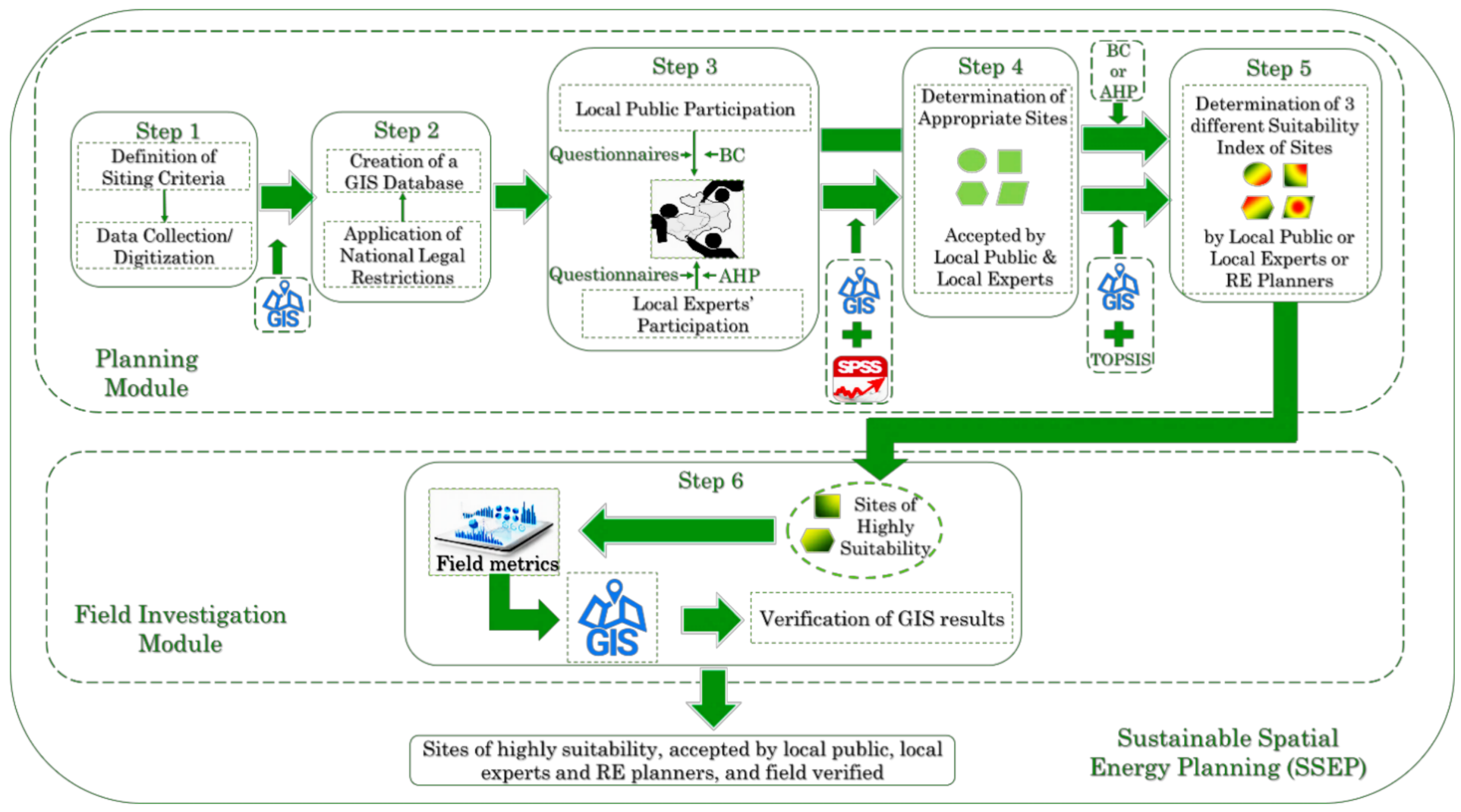
2. Overview of the Sustainable Spatial Energy Planning Framework

In order to identify the most appropriate, technically/economically feasible, environmentally sustainable and socially acceptable site solutions for the deployment of large-scale WFs and PVFs in Israel, the SSEP framework shown in Figure 1 is developed and applied.
The proposed SSEP framework corresponds to a well-structured collaborative and participatory planning approach and it consists of six distinctive, successive steps allocated into two modules: the Planning module and the Field Investigation module. The Planning module aims at determining the suitability of the potential sites and it includes five steps (Steps 1–5, Figure 1). Specifically, in Step 1, the SC are defined and all required geographic information data are collected/digitized based on the special characteristics of the study area (Israel), the special siting requirements of each RET, and the REPs’ expertise. Next, in Step 2, a RES GIS database is developed for configuring and illustrating in the form of thematic maps, the spatial dimension of each SC in a GIS environment. Step 3 follows, which is related to the LP and LE participation within the site-selection process and, more specifically, in the formation of the SC exclusion limits and the prioritization of the AC. The next step (Step 4) includes the identification of appropriate sites. This is achieved by eliminating all unsuitable areas based on specific SC and by considering the LP and the LEs’ opinion. Finally, in Step 5, the suitability of the potential sites is determined, and three different SI maps are developed in accordance with: (i) LP view and concerns, (ii) LEs’ knowledge and experience as well as, (iii) REPs’ expertise. The most highly suitable sites obtained from the Planning module, are then considered as input in the Field Investigation module (Step 6 of the SSEP framework, Figure 1), aiming at verifying the corresponding GIS results based on field observations. In this way, a set of highly suitable, accepted by LP, LEs, and REPs, and field verified sites for the deployment of large-scale onshore WFs and PVFs in Israel on national scale is obtained. This set represents the overall output of the proposed SSEP. It is noted that the proposed framework could be implemented by a group of REPs, which in the present investigation is assumed to include the authors of the paper. In the following sections, the modules and the steps of the proposed SSEP framework are described thoroughly.

3. The Planning Module

3.1. Definition of SC and Data Collection/Digitization (Step 1)

In Step 1, the SC for WFs and PVFs are initially defined based on the special characteristics and the policies of the study area, the available analog or digital geographic information data, the special siting requirements of each RET, and the expertise of the REPs. These criteria enable to identify and analyze spatially the environmental, economic, technical, political, social, and legal characteristics of the study area. For each of the examined RET, eighteen (18) SC have been taken into account, denoted hereafter as WSC for WFs and SSC for PVFs (Table 1). Detailed description of the WSC and the SSC is given in Appendix A. All relevant required geographic information data were collected from various sources (i.e., national institutes, services, and official international and national digital databases providing officially approved cartographic data), they were appropriately processed and Geographic Information Datasets (GIDs) were finally obtained (Table 1) by deploying GIS. It is noted that 10-year or 11-year suitable statistical analysis has been also conducted to obtain the final data of some essential SC (e.g., SSC.1 and SSC.2).

3.2. Development of a RES GIS Database (Step 2)

In Step 2, a RES GIS database including relevant thematic maps was developed in GIS in order to: (a) illustrate the spatial dimension of each SC and, hence, (b) support the implementation of the remaining SSEP steps by facilitating the assessment of the positive or the negative spatial impact of each SC on the WFs’ and PVFs’ site-selection processes in Israel. For this development, the national legal restrictions resulted from all existing relevant policies [48,49,50,51] have been taken into account.

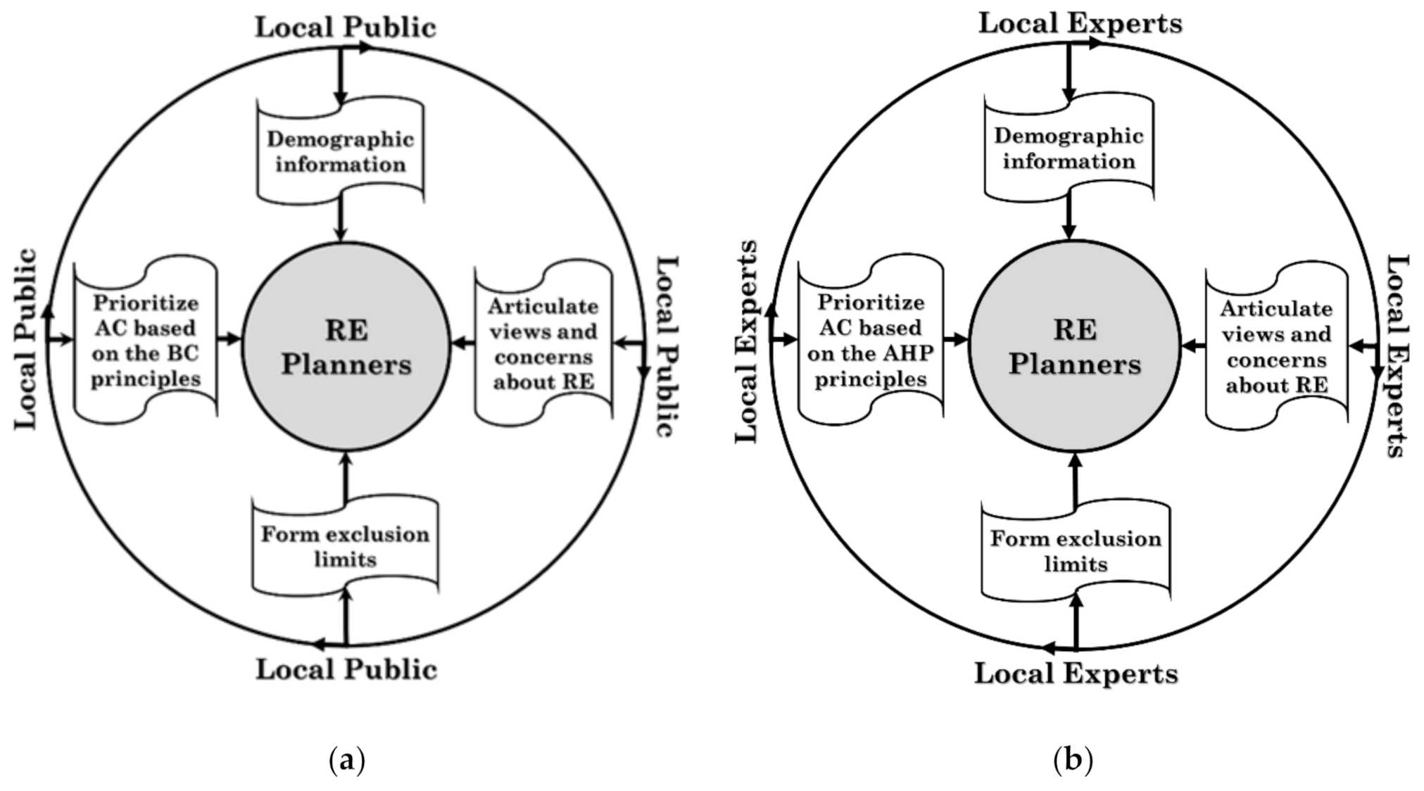
3.3. Local Public and Local Experts’ Participation in the Site-Selection Processes (Step 3)

For implementing Step 3, two participatory techniques have been developed (Figure 2) in accordance with each group (LP and LE) facilitating these two groups’ efficient involvement within the site-selection processes and, more specifically, in Step 4 and Step 5 of the proposed SSEP framework (Figure 1). The first technique (Figure 2a) corresponds to a public participatory technique, and it is based on the utilization of a well-structured questionnaire, where focus is given on essential social SC, while the AC are prioritized in accordance with the principles of the BC method. The second one (Figure 2b) corresponds to an experts’ participatory technique. It is based on the deployment of a well-structured questionnaire, where, contrary to the LP questionnaire, focus is given on essential economic, technical, environmental, and political SC, while the AC are prioritized in accordance with the principles of the AHP method. Details about these two techniques are given in the sections that follow.

3.3.1. Local Public Participation in the Site-Selection Processes

The questionnaire for the LP has been structured into four main sections. The first section was devoted to the collection of demographic information of the participants (e.g., gender, age, education, and professional occupation related or not to RE), while the second section focused on the LP opinion about the deployment of RET for electricity generation (e.g., types of RETs that the LP recommends for the RES exploitation in Israel). The third section of the LP questionnaire included questions related to the site-selection for both examined RETs (i.e., exclusion limits for essential social SC, such as “the most appropriate distance of WFs and PVFs from residential areas”). Finally, in the fourth section of the LP questionnaire, the participants were asked to prioritize 12 AC for the deployment of isolated WFs and PVFs based on their own different preferences. This prioritization was achieved according to the principles of the BC method. BC represents a social choice method that is generated by a large group of people for decision-making purposes, and it is characterized by anonymity, neutrality, and consistency [47]. In the BC social choice method, the participants of the decision-making issue rank the alternatives (the AC in our case) in order of their preference. Once all the responses have been obtained, the preference order can be determined.
In the present study, 200 fully-completed questionnaires have been obtained by the LP from all over Israel (North, Central and South part). This geographic segmentation enabled to investigate potential different policy orientations on the siting problem of WFs and PVFs driven by quite different geographic locations. The results of the LP questionnaire survey have been appropriately processed by performing statistical and correlation analysis using the built-in tools of the SPSS software. In this way, essential insights related to the deployment of WFs and PVFs in Israel based on the LP views and concerns have been revealed. Moreover, the overall, among all LP participants, exclusion limits for social SC have been obtained as well as the overall relevant importance (i.e., relevant weights) of the AC with respect to the goal of the examined decision-making problems (siting of WFs or PVFs).

3.3.2. Local Experts’ Participation in the Site-Selection Processes

In the case of the LEs, the relevant questionnaire has been again structured into four main sections similar with those of the LP questionnaire. However, the questions in the third section of the LEs’ questionnaire were related to the definition of exclusion limits for essential economic, technical, environmental, and political SC (e.g., WSC.1, SSC.1, and WSC.2/SSC.3 in Table 1), while, in the fourth section of the LEs’ questionnaire, the participants were asked to prioritize the 12 AC in accordance with the principles of the AHP method [65,66]. In that respect, each LE performed pairwise comparisons between the AC and quantified the relative importance of each AC with respect to the goal (siting of WFs and PVFs) by deploying the fundamental nine point’s scale of the AHP. The corresponding results were further processed to obtain the relative weights of the compared criteria and, thus, to form the priority vector. The robustness of the pairwise comparisons was assessed by calculating the consistency index and the consistency ratio [67]. The overall, among all participating LEs, priority vector has been calculated by employing the aggregating individual priorities technique (i.e., aggregation of all the individual priorities) [68,69], since in the present investigation, each LE acts as an independent individual.
The LEs’ group involved in the present study consisted of 4 LEs (doctoral researchers, senior managers, and professional engineers in RE) from universities and companies from all over Israel, carefully selected, considering their background on the siting of WFs and/or PVFs. These LEs quantified the exclusion limits of several essential SC and prioritized the AC based on their own high experience, high-level of knowledge on the local climatic conditions, and on the special characteristics of the study area, as well as the availability of the land in Israel. It is noted that the number of LEs participated in the present work is a bit larger compared to other previous relevant studies, where the opinion of one [23] or two [17] or three [26] experts was taken into account.

3.4. Determination of Appropriate Sites (Step 4)

In Step 4, areas unsuitable for the siting of WFs and PVFs are identified and excluded from further analysis. Hence, appropriate sites for the potential deployment of the aforementioned RETs are, finally, determined. Unsuitable areas are identified by employing the SC thematic maps of the RES GIS database developed in Step 2 along with the exclusion limits of essential SC as resulted from the LP and LEs’ questionnaire surveys in Step 3. The SC along with their siting aspect and their incompatibility zones for the case of WFs and PVFs are shown in Table 2 and Table 3, respectively. For determining unsuitable areas, two linear geoprocessing models (one for the WFs’ and one for the PVFs’ site-selection) have been created, edited and managed by building all required geoprocessing workflows in a GIS environment.

3.5. Determination of SI of the Appropriate Sites (Step 5)

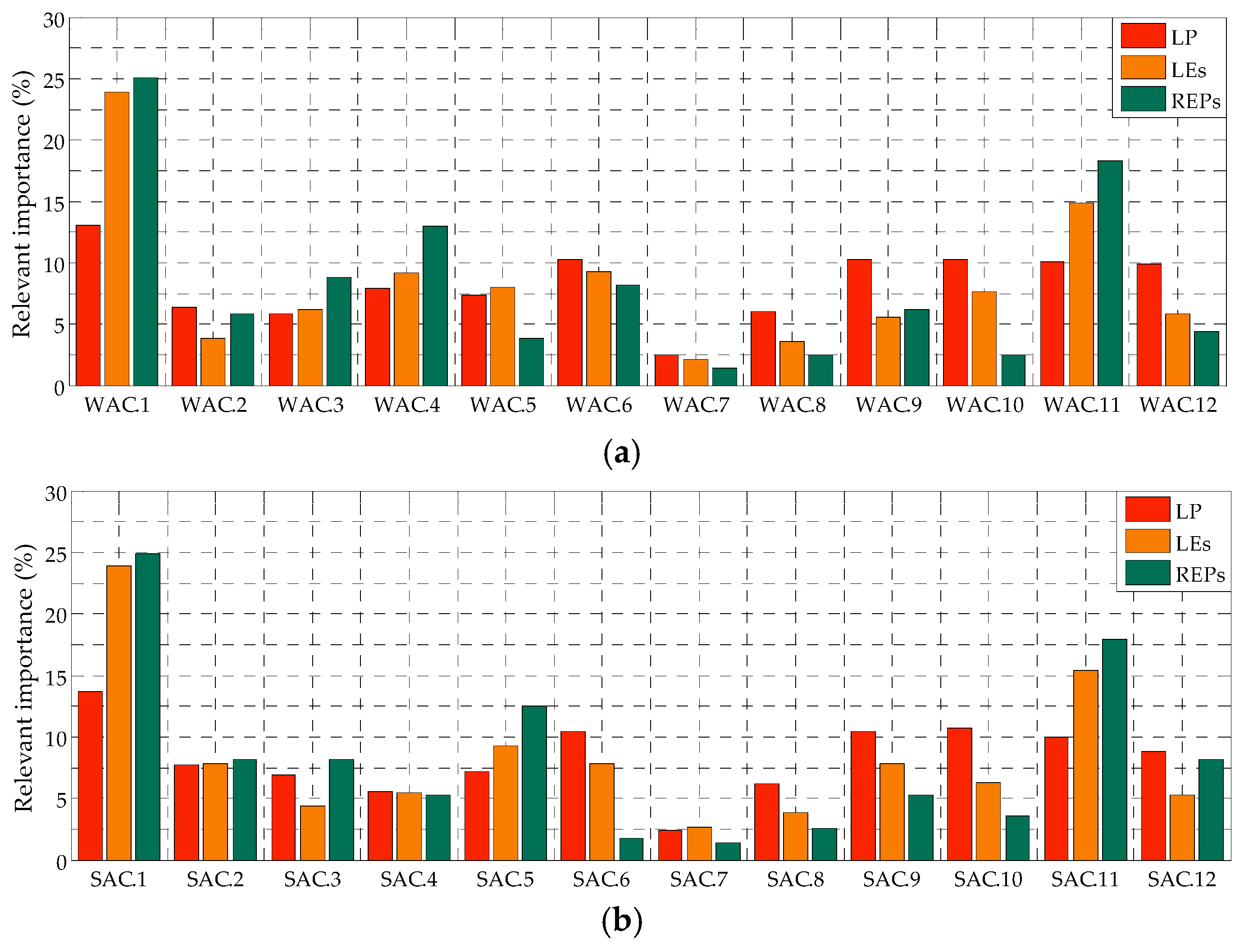
3.5.1. Definition of AC

In order to prioritize the appropriate areas for large-scale WFs’ and PVFs’ siting, 12 AC have been defined (hereafter called WAC and SAC for wind and solar energy exploitation, respectively). Specifically, in the case of WFs, the appropriate areas resulting from Step 4 are assessed and prioritized according to the following 12 WAC: wind velocity (WAC.1), slope of terrain (WAC.2), proximity to road network (WAC.3), proximity to high-voltage electricity grid (WAC.4), distance from land protected areas (WAC.5), distance from important birds areas (WAC.6), distance from touristic zones (WAC.7), distance from archaeological, historical, and cultural areas (WAC.8), land use (WAC.9), proximity to areas with high population (WAC.10), wind energy potential (WAC.11), and visibility from the residential areas (WAC.12). As for PVFs, the appropriate land areas resulting from Step 4 are assessed and prioritized according to the following 12 SAC: GHI (SAC.1), average maximum temperature (SAC.2), slope of terrain (SAC.3), proximity to road network (SAC.4), proximity to high-voltage electricity grid (SAC.5), distance from land protected areas (SAC.6), distance from touristic zones (SAC.7), distance from archaeological, historical, and cultural areas (SAC.8), land use (SAC.9), proximity to areas with high population (SAC.10), solar energy potential (SAC.11), and land aspect (SAC.12). The criteria that are introduced for the first time in this paper as AC, are described in Appendix B.

3.5.2. Inclusion of AC Importance by Each Participatory Group

The prioritization of the AC in the WFs’ and the PVFs’ site suitability analysis was made according to the outcome of the LP and the LEs’ questionnaire surveys (Step 3 of the proposed SSEP framework) as previously described in Section 3.3. Additionally, to these two groups, the relevant importance of the AC has been also quantified by the authors of this paper (herein refereed as REPs) based on their own expertise in spatial and RE planning. This quantification was implemented in accordance with the principles of the AHP method as in the case of the LEs’ group. It is noted that the different backgrounds of the three participating groups may reflect different policy orientations of the examined RE siting problems. Thus, the complexity of such critical planning issues can be revealed.
Based on all the above, Figure 3 shows the relevant importance (%) of the WAC and SAC as obtained from the LP, the LEs, and the REPs. Compared to LEs and REPs, the LP emphasizes mostly on the importance of the social and environmental aspects of the present site-selection processes, since the results of the LP questionnaire survey led to the largest relevant weights for WAC.10, WAC.9, WAC.12, WAC.6, and WAC.8 and for SAC.6, SAC.10, SAC.9, and SAC.8, among all three participatory groups. At the same time, however, the LP seems to acknowledge the importance of the existence of high wind velocity and GHI in the potential sites, since for this group, large relevant weights have been also obtained for WAC.1 and SAC.1. Comparing the LEs’ results with those of the REPs, it can be concluded that REPs follow a clear technoeconomic policy orientation of the siting issue, whereas LEs focus mostly on both economic and environmental AC. Finally, all three participatory groups provide the smallest weight to WAC.7 and SAC.7.

3.5.3. Site Suitability Analysis

Having defined and prioritized the AC, site suitability analysis of the appropriate sites of Step 4 is implemented. This is achieved by utilizing the TOPSIS method [70,71]. More specifically, the values of each AC are, initially, expressed into a common and objective SI scale by deploying a 10-point suitability scale. Table 4 shows indicatively the suitability classification of 4 essential WAC and SAC. Next, an m × n initial decision matrix is established, where m represents the number of alternative sites and n, the number of AC. The normalization of this matrix follows. The relative weights of the AC as obtained from the application of the BC or the AHP method (depending upon the participatory group) are then taken into account in order to estimate a weighted normalized decision matrix. The prioritization of the sites and the determination of an initial SI follows. Lastly, the 10-point suitability scale is deployed to determine the final SI and the corresponding results are incorporated in GIS for illustrating the spatial suitability allocation of the proposed sites. In the present work, for each examined RET, three site suitability analyses have been implemented, taking into account the opinion of each participatory group separately. In this way, different potential site-selection plans for the sustainable deployment of WFs and PVFs in Israel can be realized.

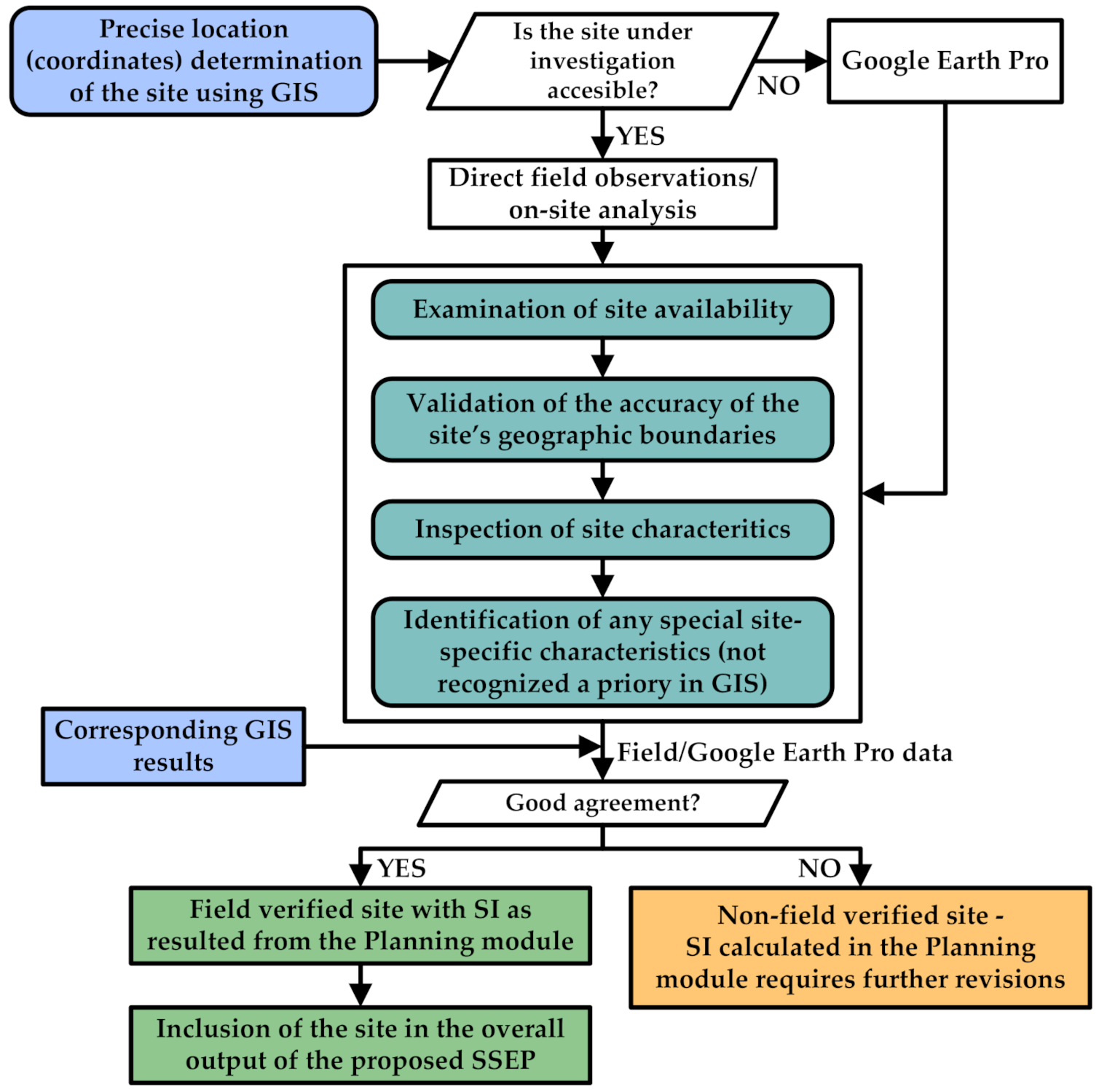
4. The Field Investigation Module (Step 6)

In the Field Investigation module (Figure 1), the sites identified in Step 5 to have high suitability (SI equal or higher than 6.0) for the siting of large-scale WFs and PVFs are selected in order to verify the corresponding GIS results by performing field observations. For achieving this, the workflow shown in Figure 4 is deployed. Initially, the precise location of the site under investigation is determined based on the coordinates available from the GIS results. Next, the site availability (i.e., no land use conflicts) is examined in the field, while, moreover, the accuracy of the determined in GIS geographic boundaries of the site is validated. The inspection of the site characteristics (e.g., land use, proximity to road network, etc.) follows along with the identification of special site-specific characteristics, which cannot be recognized in GIS (e.g., land occupation restrictions). Having implemented all the above, the field data are compared with the corresponding GIS results. If these data/results agree well, the SI calculated in the Planning module does not require any update, the examined site is characterized as “field verified,” and it is, thus, considered as an element of the overall output of the proposed SSEP. The opposite holds true in cases, where the agreement between the field data and the GIS results is not adequate. It is noted that for inaccessible locations, where direct field observations/on-site analysis cannot be realized, Google Earth Pro software is alternatively deployed as shown in Figure 4. This tool is also employed to verify the slope of terrain and the elevation of the examined sites. Table 5 shows the site characteristics examined in the present investigation by direct field observations and/or by deploying the Google Earth Pro software.

5. Results and Discussion

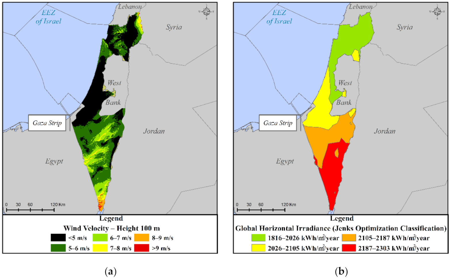
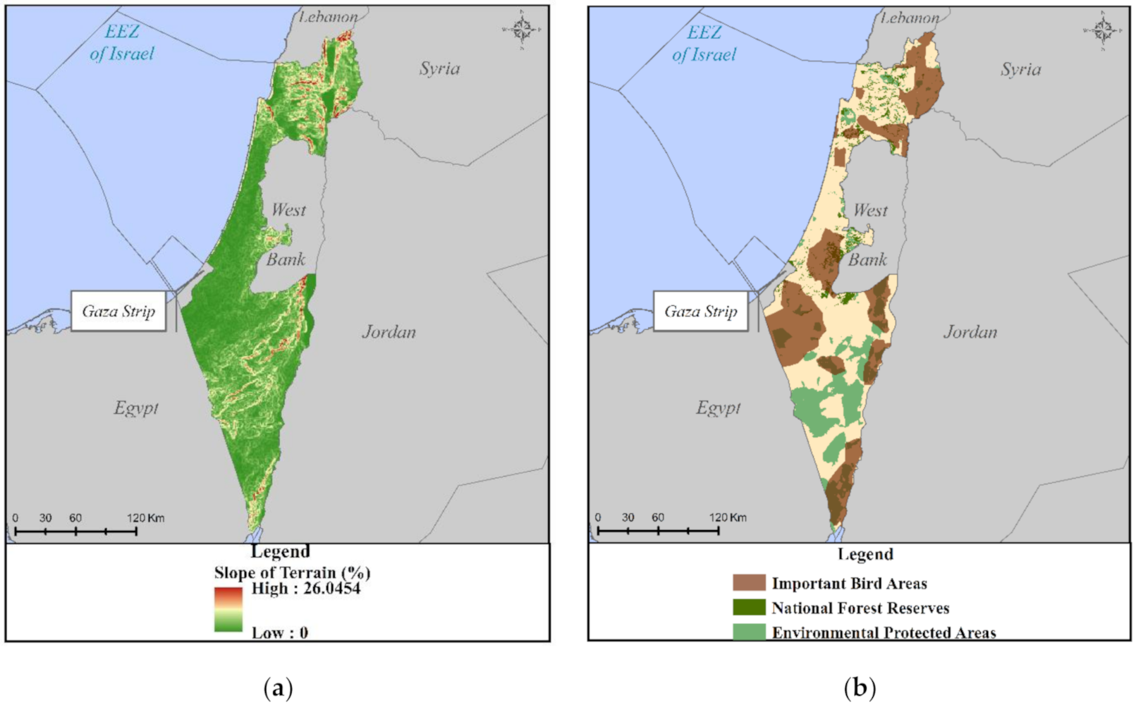
5.1. Creation of SC Thematic Maps

Numerous thematic maps were created to depict the spatial dimension of SC in WFs’ and PVFs’ site-selection processes.
Indicatively, Figure 5a,b includes the thematic maps of WSC.1 (wind velocity at 100 m height above the ground level, 10-year analysis) and of SSC.1 (GHI, 11-year analysis), respectively, while the thematic maps of WSC.2/SSC.3 (slope of terrain) and of WSC.8/SSC.9 (distance from land protected areas) along with WSC.17 (distance from important bird areas) are shown in Figure 6a,b, respectively.

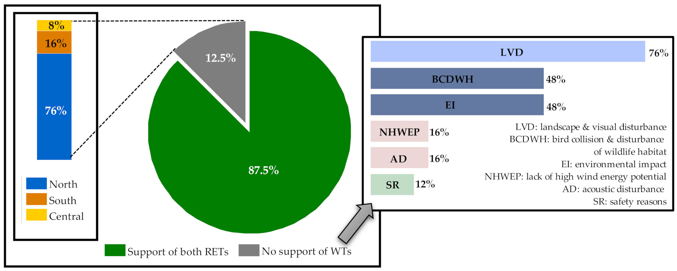
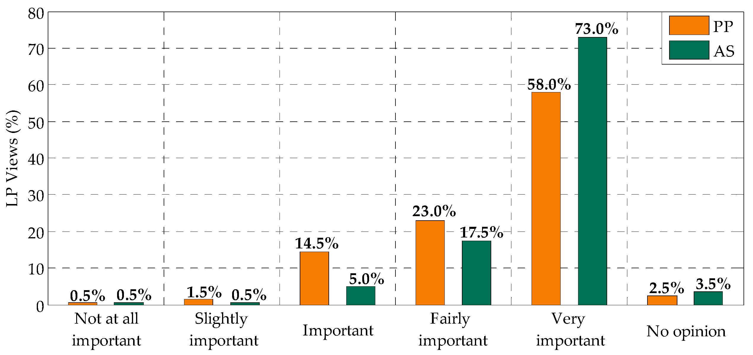
5.2. Insights from the Local Public Participatory Process

LP participation in the examined WFs and PVFs site-selection processes revealed valuable insights for the proper management of the LP prospective negative reactions to the RETs’ deployment in the country of Israel.
As shown in Figure 7, most citizens (87.5%) supported the development of both RETs in Israel, whereas 12.5% of the citizens participating in the LP questionnaire survey expressed a negative attitude towards the deployment of Wind Turbines (WTs). The latter percentage corresponds to citizens who mainly live in the Northern part of Israel, near to either existing or planned WFs’ sites. The observed opposition against WTs was attributed to (in descending order, Figure 7): (a) landscape and visual disturbance (LVD), (b) bird collision and disturbance of wildlife habitat (BCDWH), (c) environmental impact (EI), (d) lack of high wind energy potential (NHWEP) in the country, (e) acoustic disturbance (AD), and (f) safety reasons (SR). It should be mentioned that the existing WFs in Israel do not comply with the restrictions of the proposed in this paper SSEP. Therefore, this could further feed their negative feelings of WFs’ deployment in Israel.
Most citizens suggested the deployment of PV projects at all construction scales (Figure 8a). However, as shown in Figure 8b, large-scale projects were popular in the Southern part of Israel (55%), since they can produce larger amounts of electricity and potentially cover the energy needs of a larger part of the population. On the other hand, small-scale projects were popular in both North and Central Israel (48.6% and 40%, respectively), due to low land availability in these parts of the country.
Finally, the results of the LP questionnaire survey indicated that “Public Participation” (PP) and “Appropriate Sites” (AS) correspond to two very important aspects in RETs’ site-selection processes (Figure 9). The high importance of participation highlighted in the present investigation is also in line with previous studies, which acknowledge that PP is crucial for the acceptance of wind energy projects [72,73,74].

5.3. Determination of Appropriate Sites

Numerous sites for WFs’ and PVFs’ deployment (203 and 1396, respectively) were identified by superimposing the thematic maps related to exclusion criteria (Table 3 and Table 4). Wind Appropriate Sites (WAS) less than 2.5 km2 and Solar Appropriate Sites (SAS) less than 5 km2 were further excluded from the analysis. Hence, 24 WAS of 160.80 km2 total surface area and 87 SAS of 742 km2 total surface area were finally considered appropriate for the potential siting of large-scale WFs and PVFs projects, respectively.

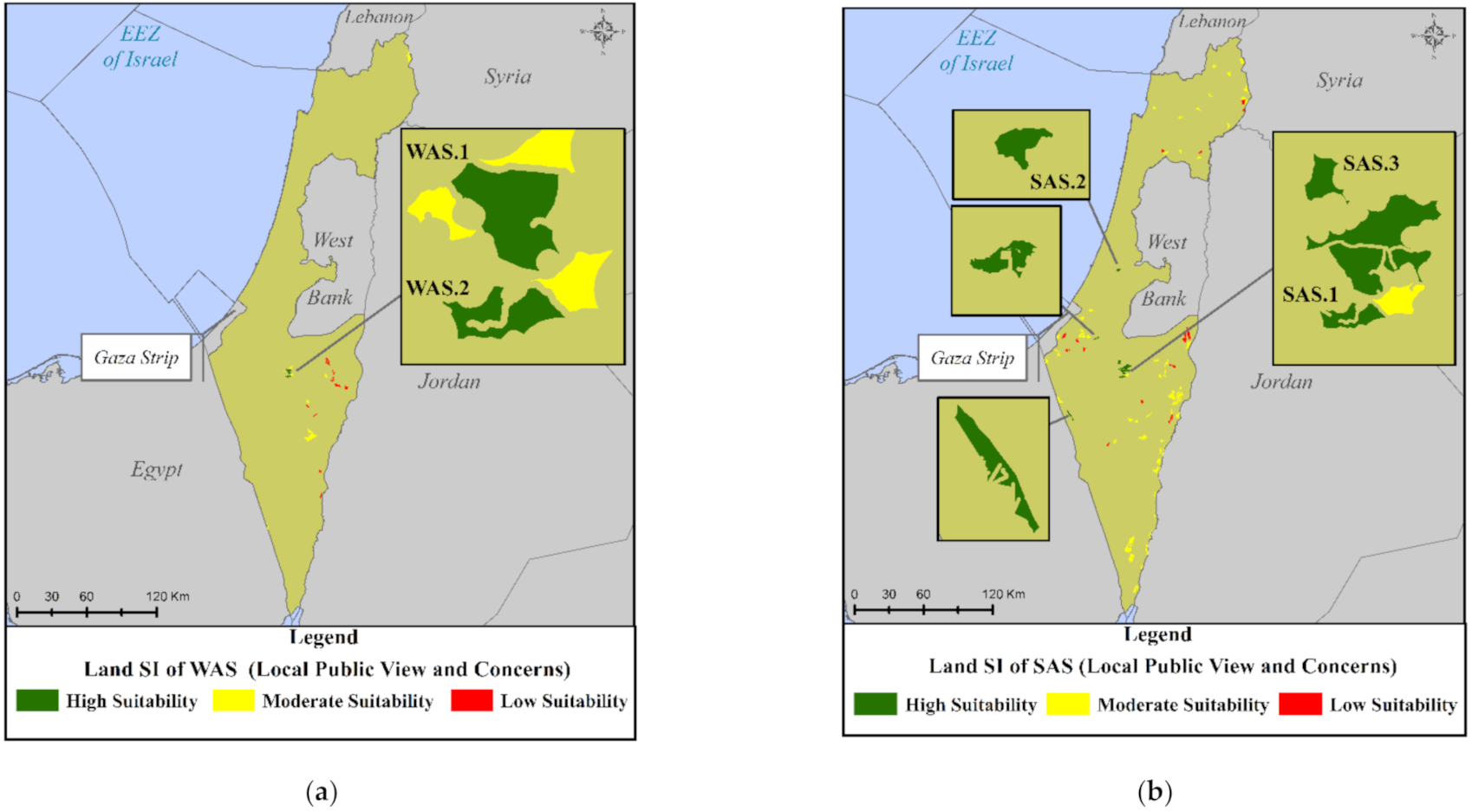
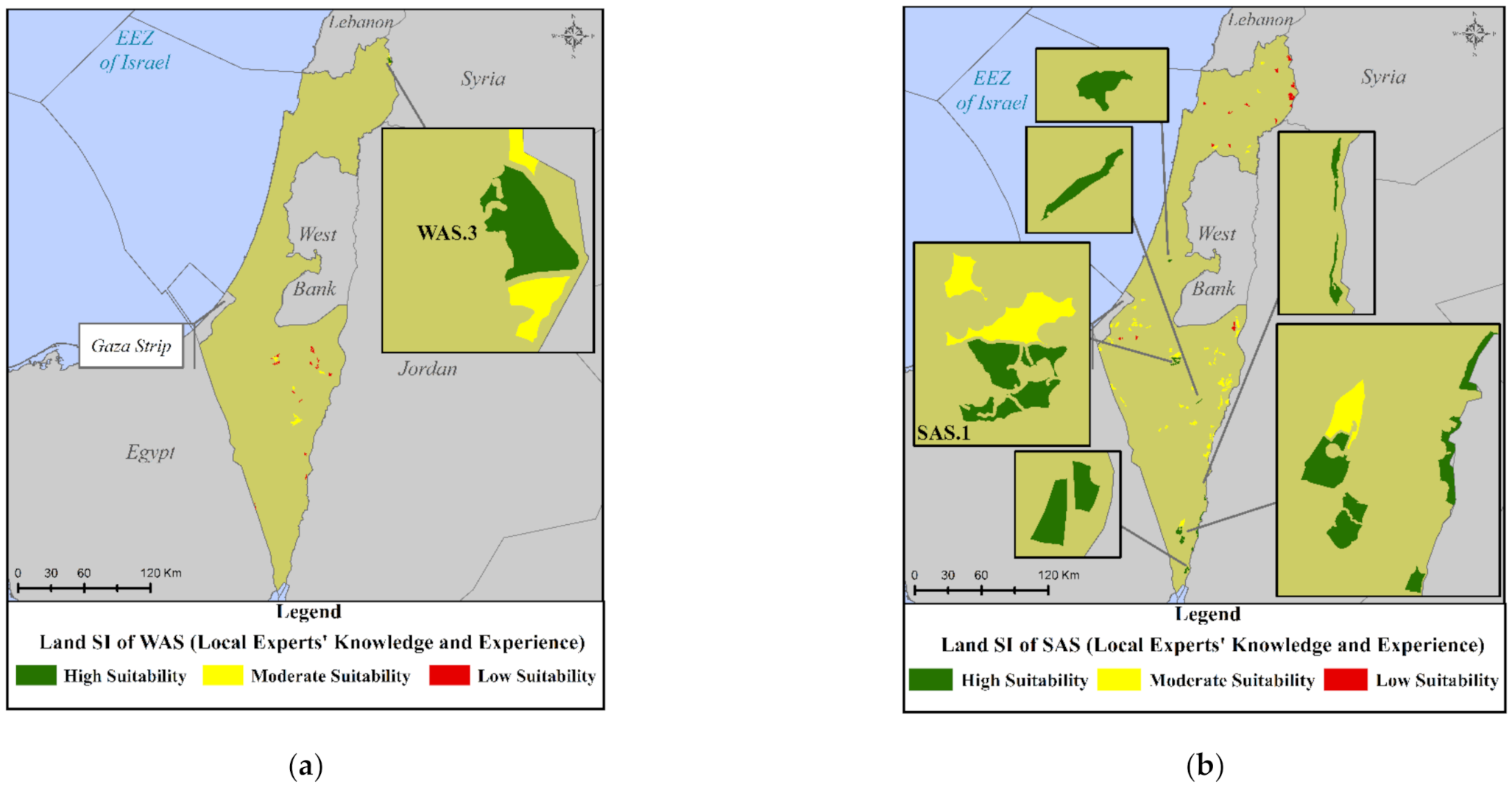
5.4. Site Suitability Analyses’ Results

Table 6 presents the results of the six site suitability analyses implemented in the last step of the Planning module, where, the SI values are classified into three classes: low suitability (0.01–3.99), moderate suitability (4.00–5.99), and high suitability (6.00–10.00). Each land SI reveals the suitability of the potential sites for the considered RETs and visualizes their spatial allocation on the final suitability maps (Figure 10, Figure 11 and Figure 12).
The results of the WFs’ site suitability analyses (Table 6) demonstrate that the highest suitability of the potential sites is obtained by considering the LP opinion (2 and 11 WAS with high and moderate suitability, respectively). On the other hand, REPs opinion determined the potential PVFs’ sites with the highest suitability (28 and 47 SAS with high and moderate suitability, respectively). As for the WAS and SAS spatial suitability allocation, Figure 10, Figure 11 and Figure 12 show the corresponding suitability maps according to LP views and concerns, LEs’ knowledge and experience and REPs’ expertise, respectively. It is noted that some sites were identified suitable for the deployment of both RETs (e.g., WAS.2 and SAS.1).
Finally, Table 7 shows the WAS (SI > 6.0) and SAS (SI > 7.0) selected to be further examined in the Field Investigation module. In this table, the area and the SI of the sites along with the corresponding participatory group that lead to this SI are also included.

5.5. Field Investigation Results

The further assessment of WAS.1-WAS.4 and SAS.1-SAS.2 (Table 7) within the Field Investigation module was implemented by performing on-site analysis/direct field observations. However, for SAS.3-SAS.8 Google Earth Pro was deployed, since those sites were not accessible. Table 8 shows the main field investigation results.
For all examined sites, GIS results were in a very good agreement with the corresponding field investigation data, proving the high credibility of the present GIS site-selection analysis. In addition, the field investigation verified the prioritization of the above sites. The special site-specific characteristics identified, included, but not limited to, the following: (a) land occupation restrictions, (b) indigenous villages that are unrecognized by the Israeli government (i.e., Bedouin villages), (c) abandon and semiruined buildings, and (d) existing PV installations (apart from large-scale projects) on SAS geographic boundaries. The final characterization of each examined site as “field verified” was implemented by considering the importance of the identified site-specific characteristics in terms of their impact on the realization of the projects. Within this context, 2 WAS and 7 SAS were characterized as “field verified” sites having an SI as resulted from the Planning module (Table 7) and, thus, they form the overall output of the proposed SSEP in the case of Israel. The remaining three sites (i.e., WAS.1, WAS.2, and SAS.1) corresponding to “non-field verified” sites, require an adequate update of their SI, since their site-specific characteristics (e.g., land occupation restrictions and indigenous villages that are unrecognized by the Israeli government (Bedouin villages)) have been considered to affect in a great extend the potential deployment of large-scale WFs or PVFs.

6. Conclusions

In the present work, we develop an innovative SSEP framework to identify and prioritize appropriate, technically and economically feasible, environmentally sustainable, as well as socially acceptable, siting solutions of large-scale WF and PVF projects at national scale. Spatial planning tools (GIS) and multi-criteria decision-making methods (AHP and TOPSIS) were combined with versatile participatory planning techniques, to actively involve three different participatory groups (LP, LEs, and REPs) into the site-selection processes. A field investigation procedure was introduced, for the first time, to verify the GIS suitability analysis results by performing direct field observations/on-site analysis, or by deploying alternative tools, such as Google Earth Pro, for sites that were inaccessible.
The proposed site-selection methodological framework was applied in Israel. Thirty criteria (SC and AC), corresponding to several economic, technical, environmental, societal, political, and legal aspects were employed for the WFs’ and PVFs’ siting. The final outcome of the proposed framework was the identification of two WAS (WAS.3 and WAS.4) situated in the North Israel and seven SAS (SAS.2–SAS.8) situated in the Central and the South Israel with high suitability for RES exploitation in Israel. The above sites were accepted by all participatory groups and they were verified in the field. Key concluding remarks of the present study can be summarized as follows:
  • An extremely high, unexploited up to now, solar energy potential in Israel has been highlighted.
  • The citizens’ negative attitude towards the deployment of wind energy projects in Israel may be related to the fact that the existing nowadays relevant projects in the country do not comply with the restrictions of the proposed in this paper SSEP.
  • The national RES GIS database developed in the present paper can contribute to an accelerated development of RES in Israel.
  • The involvement of different participatory groups (e.g., experts and public) into the spatial planning process has revealed the potential to exploit the experts’ high knowledge and valuable experience by understanding/acknowledging at the same time the public concerns; hence, the aforementioned involvement can significantly boost the deployment of wind and solar energy projects.
  • The existence of high suitable sites for large-scale WFs’ and PVFs’ siting in Israel illustrates that large-scale RES projects have the potential to contribute effectively towards the fulfillment of the national energy targets in the near future.
  • The results of the present paper could be further utilized within the context of creating a national energy roadmap in Israel.
The proposed methodology includes successive modules and definite steps and can be applied in several study areas and for various spatial planning scales. It could be also further extended by integrating drone technologies within the Field Investigation module in order to identify/map special site-specific characteristics and, thus, update, if necessary, the SI calculated in GIS. Finally, an ecological impact assessment study should accompany each proposed project in selected WAS and SAS, since the entire land of Israel is of significant importance in terms of biological diversity.

Author Contributions

Conceptualization, S.S., H.U., D.M., E.L. and D.G.V.; methodology, S.S., E.L., D.G.V., H.U. and D.M.; software, S.S.; validation, S.S. and G.S.; formal analysis, S.S.; investigation, S.S. and G.S.; data curation, S.S.; writing—original draft preparation, S.S. and G.S.; writing—review and editing, E.L., D.G.V., D.M. and H.U.; visualization, S.S.; supervision, E.L., D.G.V., H.U. and D.M. All authors have read and agreed to the published version of the manuscript.

Funding

This research was funded by the EUROPEAN UNION’s HORIZON 2020 RESEARCH and INNOVATION PROGRAMME under the Marie Skłodowska-Curie grant agreement No. 778039 (Project: “Planning and Engagement Arenas for Renewable Energy Landscapes” (PEARLS)).

Acknowledgments

The authors would like to thank Na’ama Teschner, Lecturer at Ben-Gurion University of the Negev, for supporting the implementation of the present research by providing information about the study area as well as Erez Peri, PhD Student at Tel Aviv University, for providing “high-voltage electricity grid” and “military zones” data.

Conflicts of Interest

The authors declare no conflict of interest. The funders had no role in the design of the study; in the collection, analyses, or interpretation of data; in the writing of the manuscript; or in the decision to publish the results.

Abbreviations

RE, Renewable Energy; RET, Renewable Energy Technology; WF, Wind Farm; PVF, Photovoltaic Farm; RES, Renewable Energy Sources; GIS, Geographic Information Systems; MCDM, Multi-Criteria Decision-Making; AHP, Analytical Hierarchy Process; LE, Local Expert; SSEP, Sustainable Spatial Energy Planning; LP, Local Public; REP, Renewable Energy Planner; SC, Siting Criterion; TOPSIS, Technique for Order Preference by Similarity to Ideal Solution; SI, Suitability Index; AC, Assessment Criterion; BC, Borda Count; GID, Geographic Information Dataset; GHI, Global Horizontal Irradiance; WAC, Wind Assessment Criterion; SAC, Solar Assessment Criterion; WT, Wind Turbine; LVD, Landscape and Visual Disturbance; BCDWH, Bird Collision and Disturbance of Wildlife Habitat; EI, Environmental Impact; LHWEP, Lack of High Wind Energy Potential; AD, acoustic disturbance; SR, Safety Reason, PP, Public Participation; AS, Appropriate Site; WAS, Wind Appropriate Site; SAS, Solar Appropriate Site.

Appendix A

A detailed description of the SC used in the present investigation is cited below.
Wind Velocity (WSC.1): Mean wind velocity at 100 m above the ground level defined according to LEs’ opinion and studies on geographic regions with relevant climatic conditions (e.g., [11]).
GHI (SSC.1): Total amount of direct normal, diffuse horizontal, and ground-reflected irradiance [24]. An 11-year statistical analysis (2006-2016) was conducted for 292 sites and GIS interpolation tools were used to estimate GHI spatially on a national scale.
Average Maximum Temperature (SSC.2): The performance of the modules of PV systems declines in high temperatures [75,76]. Average maximum temperature is selected, instead of mean temperature [e.g., 24,33,39], due to relatively high temperatures in Israel, especially during the summer period. A 10-year statistical analysis (2009–2018) of average maximum air temperature has been conducted for 292 sites and GIS interpolation tools were used to estimate the average maximum temperature spatially on a national scale.
Slope of Terrain (WSC.2/SSC.3): Slope of terrain affects the project’s investment cost. Larger slopes lead to larger installation costs.
Elevation (WSC.3/ SSC.4): Sites in high altitudes are avoided for large-scale WFs and PVFs, since in those altitudes, rare flora and fauna species are commonly grown, while the road and the electricity grid are frequently inadequate [77].
Military Zones (WSC.4/SSC.5): Land areas officially used by the National Army for training and other purposes or as firing fields; thus, they cannot be considered for any other use.
Distance from the Existing Road Network (WSC.5/SSC.6): The distance of a WF or PVF from the existing road network could affect the construction/maintenance costs and it could cause adverse effects (e.g., deforestation) in the environment due to road construction [18]. A minimum distance is defined for safety and aesthetic reasons as well as a maximum threshold for reducing associated costs and environmental concerns.
Distance from the Railways Network (WSC.6/SSC.7): The existing railways network and a proper buffer zone from it are excluded for safety, technical, and social reasons.
Distance from the Existing High-Voltage Electricity Grid (WSC.7/SSC.8): A proper safety distance is defined from the national electricity grid to avoid any grid damage during WFs’ and PVFs’ installation along with a maximum threshold from it to avoid high construction/installation costs. Connection to the high or extra high-voltage grid is selected, due to risks (e.g., cable destruction due to grid overloading) associated with medium or low voltage grid [78,79].
Distance from Land Protected Areas (WSC.8/SSC.9): Appropriate distance from national environmental protected areas (i.e., nature reserves and national parks) and national forests (if necessary) for preserving their environmental importance.
Distance from Civil and Military Aviation Areas (WSC.9/SSC.10): The operation of WTs disturbs significantly the airports’ surveillance radar signals [43], while the glint from PV panels can distract pilots’ vision and disturb also airports’ radars if PV panels are located close to one another [43]. Two different safety distances have been applied from all civil and military aviation areas (airports, airbases, public, or private airfields) in Israel.
Landscape Protection/Visual and Acoustic Disturbance (WSC.10/SSC.11): Appropriate distance from residential areas and solitary residences contributing to landscape protection, visual, and acoustic disturbances avoidance and social acceptance.
Distance from Touristic Zones (WSC.11/SSC.12): Appropriate distance from touristic sites (hotels, guesthouses and observation points, and tourist attractions) to reduce public concerns towards wind and solar energy.
Distance from Mineral Extraction Sites/Quarrying (WSC.12/SSC.13): Appropriate distance from land areas officially used for mineral extraction/quarrying based on their low aesthetic value and high energy needs.
Distance from Economic Activities (WSC.13/SSC.14): Appropriate distance from land areas officially used for industrial and commercial zones.
Distance from Archaeological, Historical, Cultural Areas (WSC.14/SSC.15): Appropriate distance from World Heritage Sites (WHS), nominated and protected by the United Nations Educational, Scientific and Cultural Organization (UNESCO), archaeological monuments, museums, historical places, and cultural areas to preserve their historical/cultural importance.
Distance from Water Areas (WSC.15/SSC.16): Appropriate distance from water bodies, rivers, canals, and streams.
Distance from Coastline (WSC.16/SSC.17): Appropriate distance from the coastline according to the national legal restrictions [49].
Distance from Important Bird Areas (WSC.17): Appropriate distance from areas hosting a variety of significant birds for reducing the potential risk of birds’ collision on the WTs and protecting rare birds’ species.
Farm Minimum Required Area (WSC.18/SSC.18): Minimum required area to enable the siting of large-scale WFs and PVFs.

Appendix B

A detailed description of AC not included in the SC of Appendix A is cited below.
Land Use (WAC.9/SAC.9): Land areas corresponding to open areas, shrubs, grass areas, meadow, vineyard, orchard, and agricultural farms. In Israel, WFs or PVFs are permitted to be proposed and installed in sites currently used as agricultural farms, vineyard, or orchard, due to the low availability of the land in the country. However, open areas are considered here as more preferable one for WFs’ or PVFs’ siting, since no land use conflict can be created.
Proximity to Areas with High Population (WAC.10/SAC.10): High population areas require high amounts of electricity, especially at the peak time of domestic electricity consumption in the study area (i.e., summer period). RETs installation near to areas with high electricity consumption could cover the increased peak electricity demand and could contribute significantly to large electricity losses’ reduction and, thus, to energy supply cost reduction.
Wind Energy Potential (WAC.11): Total amount of energy that a potential onshore wind project could generate. The larger the WAC.11 value is, the higher the SI is for the specific AC. For each appropriate site, WAC.11 was quantified based on: (a) the land requirements for generating 1 MW from WTs according to the LEs’ opinion and (b) the area factor indicating the fraction of the area that can be covered by WTs. This factor was defined based on previous studies related to the proper micrositing configuration in WFs [80].
Visibility from the Residential Areas (WAC.12): Distance and altitude at which an WF can be seen from a resident with an unaided eye. Relevant visibility maps are produced based on the elevation raster of the total surface area of Israel and they illustrate areas, where an installed WT with total height equal to 150 m is visible or not from the residential areas. The referred height is defined by the LEs based on the existing and future standards of WFs in Israel. The higher the degree of visibility from the residential areas is, the lower the SI is.
Solar Energy Potential (SAC.11): Total amount of energy that a potential PV project could generate. The larger the SAC.11 value is, the higher the SI is for the specific AC. For each appropriate site, SAC.11 was quantified based on: (a) the land requirements for generating 1 MW from PV panels according to the LEs’ opinion, (b) the existing standards and best practices of PV projects in Israel, as well as (c) the area factor, taken equal to 70% according to the maximum load occupancy of PV panels with the minimum shading effect [35,38].
Land Aspect (SAC.12): Compass direction (e.g., Northern, Southern, or Western) that a slope faces in the proposed site. SAC.12 is quite important for the efficiency of PV installations, since it is directly linked with the amount of solar energy that could be produced during the daytime [77]. The south-oriented appropriate sites receive the highest suitability values [24,28,36].

References

  1. REN21. Renewables 2020 Global Status Report; REN21 Secretariat: Paris, France, 2020. [Google Scholar]
  2. REN21. Renewables 2019 Global Status Report; REN21 Secretariat: Paris, France, 2019. [Google Scholar]
  3. Lee, J.; Zhao, F. Global Wind Report 2019; Global Wind Energy Council: Brussels, Belgium, 2020. [Google Scholar]
  4. IEA PVPS TCP. Snapshot of Global PV Markets 2020; The International Energy Agency (IEA): Paris, France, 2020. [Google Scholar]
  5. Environmental Protection Minister Gila Gamliel: Govt. Decision to Have 30% Renewables by 2030 Isn’t Ambitious Enough. Available online: https://www.gov.il/en/departments/news/gamliel_says_30_percent_renewables_by_2030_not_ambitious_enough (accessed on 18 December 2020).
  6. Electricity Authority: Renewable Energy Market Momentum in Israel—A Swing Market. Available online: https://www.gov.il/he/departments/news/new_energy_19102020 (accessed on 18 December 2020).
  7. Höfer, T.; Sunak, Y.; Siddique, H.; Madlener, R. Wind farm siting using a spatial Analytic Hierarchy Process approach: A case study of the Städteregion Aachen. Appl. Energy 2016, 163, 222–243. [Google Scholar] [CrossRef]
  8. Ramirez-Rosado, I.J.; Garcia-Garrido, E.; Fernandez-Jimenez, A.; Zorzano-Santamaria, P.J.; Monteiro, C.; Miranda, V. Promotion of new wind farms based on a decision support system. Renew. Energy 2008, 33, 558–566. [Google Scholar] [CrossRef] [Green Version]
  9. Latinopoulos, D.; Kechagia, K. A GIS-based multi-criteria evaluation for wind farm site selection. A regional scale application in Greece. Renew. Energy 2015, 78, 550–560. [Google Scholar] [CrossRef]
  10. Haaren, R.V.; Fthenakis, V. GIS-based wind farm site selection using spatial multi-criteria analysis (SMCA): Evaluating the case for New York State. Renew. Sustain. Energy Rev. 2011, 15, 3332–3340. [Google Scholar] [CrossRef]
  11. Baseer, M.A.; Rehman, S.; Meyer, J.P.; Mahbub Alam, Md. GIS-based site suitability analysis for wind farm development in Saudi Arabia. Energy 2017, 141, 1166–1176. [Google Scholar] [CrossRef] [Green Version]
  12. Siyal, S.H.; Mörtberg, U.; Mentis, D.; Welsch, M.; Babelon, I.; Howells, M. Wind energy assessment considering geographic and environmental restrictions in Sweden: A GIS-based approach. Energy 2015, 83, 447–461. [Google Scholar] [CrossRef]
  13. Bennui, A.; Rattanamanee, P.; Puetpaiboon, U.; Phukpattaranont, P.; Chetpattananondh, K. Site selection for large wind turbine using GIS. In Proceedings of the 3rd International Conference on Engineering and Environment, Phuket, Thailand, 10–11 May 2007. [Google Scholar]
  14. Georgiou, A.; Polatidis, H.; Haralambopoulos, D. Wind Energy Resource Assessment and Development: Decision Analysis for Site Evaluation and Application. Energy Source. Part A 2012, 34, 1759–1767. [Google Scholar] [CrossRef]
  15. Noorollahi, Y.; Itoi, R.; Fujii, H.; Tanaka, T. GIS integration model for geothermal exploration and well siting. Geothermics 2008, 37, 107–131. [Google Scholar] [CrossRef]
  16. Tegou, L.-I.; Polatidis, H.; Haralambopoulos, D.A. Environmental management framework for wind farm siting: Methodology and case study. J. Environ. Manag. 2010, 91, 2134–2147. [Google Scholar] [CrossRef]
  17. Bili, A.; Vagiona, D.G. Use of multicriteria analysis and GIS for selecting sites for onshore wind farms: The case of Andros Island (Greece). Eur. J. Environ. Sci. 2018, 8, 5–13. [Google Scholar] [CrossRef]
  18. Panagiotidou, M.; Xydis, G.; Koroneos, C. Environmental Siting Framework for Wind Farms: A Case Study in the Dodecanese Islands. Resources 2016, 5, 24. [Google Scholar] [CrossRef] [Green Version]
  19. Sarpong, D.; Baffoe, P.E. Selecting Suitable Sites for Wind Energy Development in Ghana. Ghana Min. J. 2016, 16, 8–20. [Google Scholar]
  20. Ayodele, T.R.; Ogunjuyigbe, A.S.O.; Odigie, O.; Munda, J.L. A multi-criteria GIS based model for wind farm site selection using interval type-2 fuzzy analytic hierarchy process: The case study of Nigeria. Appl. Energy 2018, 228, 1853–1869. [Google Scholar] [CrossRef]
  21. Harper, M.; Anderson, B.; James, P.; Bahaj, A. Identifying suitable locations for onshore wind turbines using a GIS-MCDA approach. In Proceedings of the 17th International Conference on Sustainable Energy Technologies, Bologna, Italy, 17–20 July 2017. [Google Scholar]
  22. Tsoutsos, T.; Tsitoura, I.; Kokologos, D.; Kalaitzakis, K. Sustainable siting process in large wind farms case study in Crete. Renew. Energy 2015, 75, 474–480. [Google Scholar] [CrossRef]
  23. Sánchez-Lozano, J.M.; García-Cascales, M.S.; Lamata, M.T. Identification and selection of potential sites for onshore wind farms development in Region of Murcia, Spain. Energy 2014, 73, 311–324. [Google Scholar] [CrossRef]
  24. Al Garni, H.Z.; Awasthi, A. Solar PV power plant site selection using a GIS-AHP based approach with application in Saudi Arabia. Appl. Energy 2017, 206, 1225–1240. [Google Scholar] [CrossRef]
  25. Sánchez-Lozano, J.M.; Teruel-Solano, J.; Soto-Elvira, P.L.; García-Cascales, M.S. Geographical Information Systems (GIS) and Multi-Criteria Decision Making (MCDM) methods for the evaluation of solar farms locations: Case study in south-eastern Spain. Renew. Sustain. Energy Rev. 2013, 24, 544–556. [Google Scholar] [CrossRef]
  26. Sánchez-Lozano, J.M.; García-Cascales, M.S.; Lamata, M.T. Comparative TOPSIS-ELECTRE TRI methods for optimal sites for photovoltaic solar farms. Case study in Spain. J. Clean. Prod. 2016, 127, 387–398. [Google Scholar] [CrossRef]
  27. Charabi, Y.; Gastli, A. PV site suitability analysis using GIS-based spatial fuzzy multi-criteria evaluation. Renew. Energy 2011, 36, 2554–2561. [Google Scholar] [CrossRef]
  28. Hott, R.; Santini, R.; Brownson, J. GIS-based spatial analysis for large-scale solar power and transmission line issues: Case study of Wyoming, U.S. In Proceedings of the 41st American Solar Energy Society Meeting, Denver, CO, USA, 13–17 May 2012. [Google Scholar]
  29. Asakereh, A.; Soleymani, M.; Sheikhdavoodi, M.J. A GIS-based Fuzzy-AHP method for the evaluation of solar farms locations: Case study in Khuzestan province, Iran. Sol. Energy 2017, 155, 342–353. [Google Scholar] [CrossRef]
  30. Merrouni, A.A.; Elalaoui, F.E.; Mezrhab, A.; Mezrhab, A.; Ghennioui, A. Large scale PV sites selection by combining GIS and Analytical Hierarchy Process. Case study: Eastern Morocco. Renew. Energy 2018, 119, 863–873. [Google Scholar] [CrossRef]
  31. Tahri, M.; Hakdaoui, M.; Maanan, M. The evaluation of solar farm locations applying Geographic Information System and Multi-Criteria Decision-Making methods: Case study in southern Morocco. Renew. Sustain. Energy Rev. 2015, 51, 1354–1362. [Google Scholar] [CrossRef]
  32. Merrouni, A.A.; Mezrhab, A.; Mezrhab, A. PV sites suitability analysis in the Eastern region of Morocco. Sustain. Energy Technol. Assess. 2016, 18, 6–15. [Google Scholar] [CrossRef]
  33. Doorga, J.R.S.; Rughooputh, S.D.D.V.; Boojhawon, R. Multi-criteria GIS-based modelling technique for identifying potential solar farm sites: A case study in Mauritius. Renew. Energy 2019, 133, 1201–1219. [Google Scholar] [CrossRef]
  34. Majumdar, D.; Pasqualetti, M.J. Analysis of land availability for utility-scale power plants and assessment of solar photovoltaic development in the state of Arizona, USA. Renew. Energy 2019, 134, 1213–1231. [Google Scholar] [CrossRef]
  35. Gastli, A.; Charabi, Y. Siting of Large PV Farms in Al-Batinah Region of Oman. In Proceedings of the 2010 IEEE International Energy Conference, Manama, Bahrain, 18–22 December 2010. [Google Scholar]
  36. Georgiou, A.; Skarlatos, D. Optimal site selection for sitting a solar park using multi-criteria decision analysis and geographical information systems. Geosci. Instrum. Meth. 2016, 5, 321–332. [Google Scholar] [CrossRef] [Green Version]
  37. Doljak, D.; Stanojevic, G. Evaluation of natural conditions for site selection of ground-mounted photovoltaic power plants in Serbia. Energy 2017, 127, 291–300. [Google Scholar] [CrossRef] [Green Version]
  38. Khan, G.; Rathi, S. Optimal Site Selection for Solar PV Power Plant in an Indian State Using Geographical Information System (GIS). Int. J. Emerg. Eng. Res. Tech. 2014, 2, 260–266. [Google Scholar]
  39. Noorollahi, E.; Fadai, D.; Shirazi, M.A.; Ghodsipour, S.H. Land Suitability Analysis for Solar Farms Exploitation Using GIS and Fuzzy Analytic Hierarchy Process (FAHP)—A Case Study of Iran. Energies 2016, 9, 643. [Google Scholar] [CrossRef] [Green Version]
  40. Al-Shammari, S.; Ko, W.; Al Ammar, E.A.; Alotaibi, M.A.; Choi, H.-J. Optimal Decision-Making in Photovoltaic System Selection in Saudi Arabia. Energies 2021, 14, 357. [Google Scholar] [CrossRef]
  41. Welder, L.; Ryberg, D.S.; Kotzur, L.; Grube, T.; Robinius, M.; Stolten, D. Spatio-Temporal Optimization of a Future Energy System for Power-to-Hydrogen Applications in Germany. Energy 2018, 158, 1130–1149. [Google Scholar] [CrossRef]
  42. Mancini, F.; Nastasi, B. Solar Energy Data Analytics: PV Deployment and Land Use. Energies 2020, 13, 417. [Google Scholar] [CrossRef] [Green Version]
  43. Ali, S.; Taweekun, J.; Techato, K.; Waewsak, J.; Gyawali, S. GIS based site suitability assessment for wind and solar farms in Songkhla, Thailand. Renew. Energy 2019, 132, 1360–1372. [Google Scholar] [CrossRef]
  44. Janke, J.R. Multicriteria GIS modeling of wind and solar farms in Colorado. Renew. Energy 2010, 35, 2228–2234. [Google Scholar] [CrossRef]
  45. Watson, J.J.W.; Hudson, M.D. Regional Scale wind farm and solar farm suitability assessment using GIS-assisted multi-criteria evaluation. Landsc. Urban Plan. 2015, 138, 20–31. [Google Scholar] [CrossRef]
  46. Sadeghi, M.; Karimi, M. GIS-based solar and wind turbine site selection using multi-criteria analysis: Case study Tehran, Iran. Int. Arch. Photogramm. Remote Sens. Spatial Inf. Sci. 2017, XLII-4/W4, 469–476. [Google Scholar] [CrossRef] [Green Version]
  47. Munda, G. Social Multi-Criteria Evaluation for a Sustainable Economy; Springer: Berlin, Germany, 2008. [Google Scholar]
  48. Israeli Ministry of Interior. Photovoltaic Facilities. In National Outline Plan 1 (TAMA 1) Instructions; Israeli Ministry of Interior: Jerusalem, Israel, 2020; pp. 46–57. [Google Scholar]
  49. Israeli Ministry of Interior. Beaches. In National Outline Plan 1 (TAMA 1) Instructions; Israeli Ministry of Interior: Jerusalem, Israel, 2020; pp. 124–133. [Google Scholar]
  50. Israeli Ministry of Interior. National Outline Plan 10\D\12 for Wind Turbines (TAMA 10\D\12); Israeli Ministry of Interior: Jerusalem, Israel, 2014; p. 98.
  51. Israeli Ministry of Interior. National Outline Plan 10\D\10 for Photovoltaic Facilities (TAMA 10\D\10); Israeli Ministry of Interior: Jerusalem, Israel, 2010; p. 26.
  52. Global Wind Atlas: Israel. Available online: https://globalwindatlas.info/area/Israel (accessed on 10 January 2020).
  53. European Commission Joint Research Centre: Photovoltaic Geographical Information System. Available online: https://re.jrc.ec.europa.eu/pvg_tools/en/tools.html (accessed on 11 October 2019).
  54. NASA: POWER Data Access Viewer. Available online: https://power.larc.nasa.gov/data-access-viewer/ (accessed on 11 October 2019).
  55. Japan Aerospace Exploration Agency: Digital Surface Model. Available online: https://www.eorc.jaxa.jp/ALOS/en/aw3d30/data/html_v1903/n020e030_n050e060.htm (accessed on 17 September 2019).
  56. Tel Aviv University. Available online: https://english.tau.ac.il/ (accessed on 13 November 2019).
  57. Planning Director—Available Planning: List of District Outline Plans. Available online: http://mavat.moin.gov.il/MavatPS/Forms/SV9.aspx?tid=92&esid=20 (accessed on 13 November 2019).
  58. OSM: Geofabrik Download Server. Available online: https://download.geofabrik.de/asia/israel-and-palestine.html (accessed on 17 September 2019).
  59. UNESCO World Heritage Centre: Israel. Available online: https://whc.unesco.org/en/statesparties/il/ (accessed on 17 September 2019).
  60. Basemaps for ArcGIS Pro, Esri. Available online: https://pro.arcgis.com/en/pro-app/help/mapping/map-authoring/author-a-basemap.htm (accessed on 14 November 2019).
  61. Israel Nature and Parks Authority: National Parks and Nature Reserves. Available online: https://www.parks.org.il/en/ (accessed on 29 October 2019).
  62. Israel Airports Authority: Airports and Terminals (Maps and Lists). Available online: https://www.iaa.gov.il/en-US/rashot/Pages/default.aspx (accessed on 19 September 2019).
  63. Aircraft Charter World: Airports in Israel. Available online: http://www.aircraft-charter-world.com/airports/middleeast/israel.htm (accessed on 24 September 2019).
  64. Maritime Boundaries: Query Database. Available online: https://www.marineregions.org/eezsearch.php (accessed on 25 September 2019).
  65. Saaty, T.L. The Analytic Hierarchy Process; McGraw-Hill: New York, NY, USA, 1980. [Google Scholar]
  66. Saaty, T.L. Axiomatic Foundation of the Analytic Hierarchy Process. Manag. Sci. 1986, 32, 841–855. [Google Scholar] [CrossRef]
  67. Saaty, R.W. The analytic hierarchy process—What it is and how it is used. Math. Model. 1987, 9, 161–176. [Google Scholar] [CrossRef] [Green Version]
  68. Forman, E.; Peniwati, K. Aggregating individual judgments and priorities with the analytic hierarchy process. Eur. J. Oper. Res. 1998, 108, 165–169. [Google Scholar] [CrossRef]
  69. Ramanathan, R.; Ganesh, L.S. Group preference aggregation methods employed in AHP: An evaluation and an intrinsic process for deriving members’ weightages. Eur. J. Oper. Res. 1994, 79, 249–265. [Google Scholar] [CrossRef]
  70. Hwang, C.L.; Yoon, K. Multiple Attribute Decision Making: Methods and Applications; Springer: New York, NY, USA, 1981. [Google Scholar]
  71. Hwang, C.-L.; Lai, Y.-J.; Liu, T.-Y. A new approach for multiple objective decision making. Comput. Oper. Res. 1993, 20, 889–899. [Google Scholar] [CrossRef]
  72. Langer, K.; Decker, T.; Menrad, K. Public participation in wind energy projects located in Germany: Which form of participation is the key to acceptance? Renew. Energy 2017, 112, 63–73. [Google Scholar] [CrossRef]
  73. Jami, A.A.; Walsh, P.R. The Role of Public Participation in Identifying Stakeholder Synergies in Wind Power Project Development: The Case Study of Ontario, Canada. Energy 2014, 68, 194–202. [Google Scholar] [CrossRef]
  74. Geißler, G.; Köppel, J.; Gunther, P. Wind Energy and Environmental Assessments—A Hard Look at Two Forerunners’ Approaches: Germany and the United States. Renew. Energy 2013, 51, 71–78. [Google Scholar] [CrossRef]
  75. Huld, T.; Amillo, A.M.G. Estimating PV module performance over large geographical regions: The role of irradiance, air temperature, wind speed and solar spectrum. Energies 2015, 8, 5159–5181. [Google Scholar] [CrossRef] [Green Version]
  76. Yelmen, B.; Çakir, M.T. Influence of temperature changes in various regions of Turkey on powers of photovoltaic solar panels. Energy Source Part A 2016, 38, 542–550. [Google Scholar] [CrossRef]
  77. Giamalaki, M.; Tsoutsos, T. Sustainable siting of solar power installations in Mediterranean using a GIS/AHP approach. Renew. Energy 2019, 141, 64–75. [Google Scholar] [CrossRef]
  78. Chaouachi, A.; Covrig, C.F.; Ardelean, M. Multi-criteria selection of offshore wind farms: Case study for the Baltic States. Energy Policy 2017, 103, 179–192. [Google Scholar] [CrossRef]
  79. Gorsevski, P.V.; Cathcart, S.C.; Mirzaei, G.; Jamali, M.M.; Ye, X.; Gomezdelcampo, E. A group-based spatial decision support system for wind farm site selection in Northwest Ohio. Energy Policy 2013, 55, 374–385. [Google Scholar] [CrossRef]
  80. Spyridonidou, S.; Vagiona, D.G.; Loukogeorgaki, E. Strategic Planning of Offshore Wind Farms in Greece. Sustainability 2020, 12, 905. [Google Scholar] [CrossRef] [Green Version]
Figure 1. Proposed Sustainable Spatial Energy Planning (SSEP) framework for large-scale Wind Farms’ (WFs’) and Photovoltaic Farms’ (PVFs’) site-selection in Israel.
Energies 14 00551 g001
Figure 2. Schematic view of the participatory techniques developed and applied in the present site-selection processes for: (a) Local Public (LP) and (b) Local Experts (LEs).
Energies 14 00551 g002
Figure 3. Relevant importance (%) of (a) Wind Assessment Criteria (WAC) and (b) Solar Assessment Criteria (SAC) based on Local Public (LP), Local Experts’ (LEs’), and Renewable Energy Planners’ (REPs’) opinion.
Energies 14 00551 g003
Figure 4. Workflow followed for the realization of the Field Investigation module (Step 6 of the proposed SSEP).
Energies 14 00551 g004
Figure 5. Thematic maps of (a) Wind Velocity (WSC.1) and (b) Global Horizontal Irradiance (GHI) (SSC.1) as defined in Table 1.
Energies 14 00551 g005
Figure 6. Thematic maps of (a) Slope of Terrain (WSC.2/SSC.3) and (b) Distance from Land Protected Areas (WSC.8/SSC.9) and Distance from Importance Bird Areas (WSC.17) as defined in Table 1.
Energies 14 00551 g006
Figure 7. Local Public (LP) views (%) on Renewable Energy Technologies (RETs) per geographic segment and causes of negative reactions towards WTs’ deployment in Israel.
Energies 14 00551 g007
Figure 8. Local Public (LP) preferences (%) on Photovoltaic (PV) projects: (a) per construction scale and (b) per both construction scale and geographic segment.
Energies 14 00551 g008
Figure 9. Local Public (LP) views (%) on the importance of Public Participation (PP) in the RETs’ site-selection processes and of Appropriate Sites (AS) for RETs.
Energies 14 00551 g009
Figure 10. Suitability Index (SI) spatial allocation based on Local Public (LP) for (a) Wind Appropriate Sites (WAS) and (b) Solar Appropriate Sites (SAS).
Energies 14 00551 g010
Figure 11. Suitability Index (SI) spatial allocation based on Local Experts (LEs) for: (a) Wind Appropriate Sites (WAS) and (b) Solar Appropriate Sites (SAS).
Energies 14 00551 g011
Figure 12. Suitability Index (SI) spatial allocation based on Renewable Energy Planners (REPs) for (a) Wind Appropriate Sites (WAS) and (b) Solar Appropriate Sites (SAS).
Energies 14 00551 g012
Table 1. Siting Criteria (SC), Geographic Information Datasets (GIDs), data processes, and sources employed in the present work.
SC No.SC NameGID No.Data Process(es)Data Source(s)
WSC.1Wind VelocityGID.1Preprocessing[52]
SSC.1Global Horizontal Irradiance (GHI)GID.2Digitization[53]
SSC.2Average Maximum TemperatureGID.3Digitization[54]
WSC.2/SSC.3Slope of TerrainGID.4Preprocessing[55]
WSC.3/SSC.4ElevationGID.4
WSC.4/SSC.5Military ZonesGID.5Collection[56,57,58]
WSC.7/SSC.8Distance from the Existing High-Voltage Electricity GridGID.5
WSC.12/SSC.13Distance from Mineral Extraction Sites/ QuarryingGID.5
WSC.5/SSC.6Distance from the Existing Road NetworkGID.6Collection and Digitization[57,58,59,60]
WSC.6/SSC.7Distance from Railways NetworkGID.6
WSC.10/SSC.11Landscape Protection/Visual and Acoustic DisturbanceGID.6
WSC.11/SSC.12Distance from Touristic ZonesGID.6
WSC.13/SSC.14Distance from Economic ActivitiesGID.6
WSC.14/SSC.15Distance from Archaeological, Historical, Cultural AreasGID.6
WSC.8/SSC.9Distance from Land Protected Areas,GID.7Collection[61]
WSC.17Distance from Important Bird AreasGID.7
WSC.9/SSC.10Distance from Civil and Military Aviation AreasGID.8Digitization[60,62,63]
WSC.15/SSC.16Distance from Water AreasGID.9Collection and Digitization[58,60]
WSC.16/SSC.17Distance from CoastlineGID.10Collection and Digitization[60,64]
WSC.18/SSC.18Farm Minimum Required AreaGID.11Preprocessing-
Table 2. Siting Criteria (SC) and their incompatibility zones for large-scale Wind Farms’ (WFs’) site-selection.
No.Siting CriterionSiting AspectUnsuitable Land Areas
WSC.1Wind VelocityEconomic<5.0 m/s
WSC.2Slope of TerrainEconomic/Technical>20%
WSC.3ElevationTechnical/Environmental>2000 m
WSC.4Military ZonesPoliticalAll
WSC.5Distance from the Existing Road NetworkEconomic/Technical/Social≤150 m and >10,000 m
WSC.6Distance from the Existing Railways NetworkTechnical/Social≤150 m
WSC.7Distance from the Existing High-Voltage Electricity GridEconomic/Technical≤150 m and >30,000 m
WSC.8Distance from Land Protected AreasEnvironmental≤500 m (environmental protected areas)
WSC.9Distance from Civil and Military Aviation AreasPolitical/Technical≤2500 m
WSC.10Landscape Protection/Visual and Acoustic DisturbanceSocial/Legal≤1900 m (urban and residential areas)
≤920 m (solitary residences)
WSC.11Distance from Touristic ZonesSocial/Economic≤1100 m
WSC.12Distance from Mineral Extraction Sites/QuarryingTechnical/Restrictive≤100 m
WSC.13Distance from Economic ActivitiesSocial/Technical≤500 m
WSC.14Distance from Archaeological, Historical and Cultural AreasSocial/Political≤1000 m (WHS)
≤500 m (rest cultural areas)
WSC.15Distance from Water AreasEnvironmental/Social≤100 m
WSC.16Distance from CoastlineEnvironmental/Social≤500 m
WSC.17Distance from Important Bird AreasEnvironmental≤500 m
WSC.18Farm Required AreaEconomic<2,500,000 m2
Table 3. Siting Criteria (SC) and their incompatibility zones for large-scale Photovoltaic Farms’ (PVFs’) site-selection.
No.Siting CriterionSiting AspectUnsuitable Land Areas
SSC.1GHIEconomic<1600 kWh/m2/year
SSC.2Average Maximum TemperatureEconomic/Technical>40 °C
SSC.3Slope of TerrainEconomic/Technical>5%
SSC.4ElevationTechnical/Environmental>2000 m
SSC.5Military ZonesPoliticalAll
SSC.6Distance from the Existing Road NetworkEconomic/Technical/Social≤150 m and >10,000 m
SSC.7Distance from the Existing Railways NetworkTechnical/Social≤150 m
SSC.8Distance from the Existing High-Voltage Electricity GridEconomic/Technical≤150 m and >30,000 m
SSC.9Distance from Land Protected AreasEnvironmental≤500 m (environmental protected areas)
SSC.10Distance from Civil and Military Aviation AreasPolitical/Technical≤1000 m
SSC.11Landscape Protection/Visual and Acoustic DisturbanceSocial/Legal≤800 m (urban and residential areas)
≤120 m (solitary residences)
SSC.12Distance from Touristic ZonesSocial/Economic≤500 m
SSC.13Distance from Mineral Extraction Sites/QuarryingTechnical/Restrictive≤100 m
SSC.14Distance from Economic ActivitiesSocial/Technical≤500 m (no buffer from Industrial Zones)
SSC.15Distance from Archaeological, Historical and Cultural AreasSocial/Political≤1000 m (WHS)
≤500 m (rest cultural areas)
SSC.16Distance from Water AreasEnvironmental/Social≤100 m
SSC.17Distance from CoastlineEnvironmental/Social≤500 m
SSC.18Farm Required AreaEconomic<5,000,000 m2
Table 4. Suitability scaling of essential Wind Assessment Criteria (WAC) and Solar Assessment Criteria (SAC).
ACSuitability Scaling
246810
WAC.1 (m/s)5–66–77–88–9>9
WAC.2 (%)-15–2010–155–100–5
WAC.4 (km)20–3015–2010–155–100.15–5
WAC.6 (km)0.5–11–22–33–4>4
SAC.1 (kWh/m2/year)-1816–20262026–21052105–21872187–2303
SAC.2 (°C)28–2927–2826–2725–26<25
SAC.3 (%)-4–53–42–30–2
SAC.5 (km)20–3015–2010–155–100.15–5
Table 5. Site characteristics examined in the present investigation within the Field Investigation module.
Site CharacteristicField Investigation Process
Land useOn-site analysis
Distance from residential areasOn-site analysis and Google Earth Pro
Geographic boundaries and shape of the siteOn-site analysis and Google Earth Pro
Proximity to road networkOn-site analysis and Google Earth Pro
Slope of terrainGoogle Earth Pro
ElevationGoogle Earth Pro
Important bird areasOn-site analysis
Environmental protected areasOn-site analysis and Google Earth Pro
Touristic zonesOn-site analysis
Archaeological, historical, and cultural areasOn-site analysis and Google Earth Pro
Land occupationOn-site analysis and Google Earth Pro
Table 6. Suitability analyses results using Geographic Information Systems (GIS) (final results of the Planning module).
Suitability Analysis No.RETParticipatory GroupSuitability ClassSuitability
1WTLPHigh Suitability2 WAS (11.12%)
Moderate Suitability11 WAS (53.59%)
Low Suitability11 WAS (35.29%)
2WTLEsHigh Suitability1 WAS (7.25%)
Moderate Suitability7 WAS (47.49%)
Low Suitability16 WAS (45.26%)
3WTREPsHigh Suitability2 WAS (9.73%)
Moderate Suitability8 WAS (51.70%)
Low Suitability14 WAS (38.57%)
4PVLPHigh Suitability8 SAS (10.49%)
Moderate Suitability63 SAS (72.82%)
Low Suitability16 SAS (16.69%)
5PVLEsHigh Suitability16 SAS (19.53%)
Moderate Suitability54 SAS (63.29%)
Low Suitability17 SAS (17.18%)
6PVREPsHigh Suitability28 SAS (35.17%)
Moderate Suitability47 SAS (51.85%)
Low Suitability12 SAS (12.98%)
Table 7. Wind Appropriate Sites (WAS) and Solar Appropriate Sites (SAS) selected to be examined in the Field Investigation module.
No.Participatory GroupArea (km2)SI Value According to GIS
WAS.1LP12.326.32
WAS.2LP5.576.32
WAS.3LEs, REPs11.667.09, 7.54
WAS.4REPs3.986.01
SAS.1LP, LEs6.678.06, 7.20
SAS.2LP6.257.26
SAS.3LP7.857.15
SAS.4REPs8.668.18
SAS.5REPs5.147.37
SAS.6REPs7.997.33
SAS.7REPs5.217.19
SAS.8REPs14.047.18
Table 8. Field investigation results.
Site No.Main Field Investigation ProcessAgreement between Field Data and GIS ResultsExistence of Special Site-Specific CharacteristicsRequirement forSI UpdateField Verified Site
WAS.1On-site analysisVery goodYesYesNo
WAS.2On-site analysisVery goodYesYesNo
WAS.3On-site analysisVery goodYesNoYes
WAS.4On-site analysisVery goodYesNoYes
SAS.1On-site analysisVery goodYesYesNo
SAS.2On-site analysisVery goodNoNoYes
SAS.3Google Earth ProVery goodYesNoYes
SAS.4Google Earth ProVery goodNoNoYes
SAS.5Google Earth ProVery goodNoNoYes
SAS.6Google Earth ProVery goodYesNoYes
SAS.7Google Earth ProVery goodNoNoYes
SAS.8Google Earth ProVery goodNoNoYes
Publisher’s Note: MDPI stays neutral with regard to jurisdictional claims in published maps and institutional affiliations.

