Review

Geology and Petroleum Systems of the East China Sea Basin

1
School of Energy Resources, China University of Geosciences (Beijing), Beijing 100083, China
2
Faculty of Earth and Life Sciences, Vrije Universiteit Amsterdam, Amsterdam 1181 HV, The Netherlands
*
Author to whom correspondence should be addressed.
Energies 2019, 12(21), 4088; https://doi.org/10.3390/en12214088
Submission received: 28 July 2019 / Revised: 14 October 2019 / Accepted: 23 October 2019 / Published: 26 October 2019

Abstract

:
The back-arc East China Sea Basin lies on extended continental crust at the leading edge of the Eurasian plate. In this study, the basins are described and subdivided according to their tectono-stratigraphic evolution. In order to distinguish between different phases of deformation in basin development, standard basin evolution patterns related to geodynamic drivers are identified as a first step. On the basis of this, standard patterns are recognized in the sedimentary sequences that characterize the area and its tectonic evolution, and linking them to the petroleum systems present is attempted. This is achieved by characterizing and grouping them into basin cycle-related petroleum system types (PSTs). Finally, the development of plays is examined within the petroleum systems in the context of their tectono-stratigraphic evolution, and groups of sub-basins with similar geological history and, therefore, potentially similar petroleum prospectivity are identified. In the East China Sea Basin, four proven and potential PSTs were recognized: (1) Late Cretaceous to Paleocene oil/gas-prone early syn-rift lacustrine–deltaic PST; (2) Eocene gas/oil prone late syn-rift marine PST; (3) Oligocene to Middle Miocene gas/oil-prone early post-rift fluvial–deltaic PST; (4) gas-prone syn-rift turbiditic PST. The geology and petroleum systems of three major sub-basins of the East China Sea Basin, the Xihu Sub-basin, the Lishui Sub-basin, and Okinawa Trough, are discussed in detail, and their petroleum systems and play development are analyzed. Finally, the sub-basins are grouped into “basin families” distinguished by their tectono-stratigraphic development, namely, Northwest to Northeast Shelf Basin (NWSB–NESB), Southwest to Southeast Shelf Basin (SWSB–SESB), and Okinawa Trough basin families, respectively.

Graphical Abstract

1. Introduction

The East China Sea contains the largest Mesozoic–Cenozoic basin of the continental margin of China, covering an area of about 770,000 km2 [1] (Figure 1). It includes the East China Sea Shelf Basin in the west and the Okinawa Trough in the east, separated from each other by the Diaoyudao paleo-uplift or Taiwan–Sinzi fold belt. The East China Sea Shelf Basin is divided into a series of sub-basins, separated by basement highs or paleo-uplifts, including the Hupijiao, Haijiao, Yushan, and Yandang paleo-uplifts. The sub-basins can be subdivided into a western group (West Shelf Basin), including the Lishui, Jiaojiang, Fuzhou, Minjiang, Qiantang, and Changjiang sub-basins, and an eastern group (East Shelf Basin), including the Diaobei, Xihu, and Fujiang sub-basins.
Several oil and gas fields and oil- and gas-bearing structures were discovered in the East China Sea Shelf Basin since the 1970s [2,3]. The known reservoirs include fluvial, lacustrine, deltaic, and shallow marine sandstones of Paleocene–Oligocene age [4]. Eocene–Oligocene fluvial–lacustrine claystones and coals buried deeply in the sub-basins are believed to be the main source rocks [4]. Paleocene deltaic and shallow marine barrier sandstones form the main reservoirs of the West Shelf Basin [5,6,7], while the main reservoirs of the East Shelf Basin are Eocene, Oligocene, and Lower Miocene sandstones, belonging to marine sedimentary facies in the south [8,9] and fluvial–lacustrine–deltaic sedimentary facies in the north [2,10,11,12]. Regional seals of the East Shelf Basin are believed to be represented by Eocene–Miocene fluvial–lacustrine claystones [2], while, within the West Shelf Basin, intra-formational claystones serve as local seals [13]. Despite extensive petroleum exploration in the area, the geological evolution and petroleum geology of the basins remain poorly documented. The basin is also a politically sensitive region because China and Japan are in stalemate over a maritime boundary dispute, affecting potential oil and gas rights in the area.
Geology and petroleum systems over the East China Sea Shelf Basin were studied bits and pieces by various researchers over the past 20 years [6,10,11,12,13,14,15]. However, there is no paper presenting an overview of the petroleum system over the entire basin, especially the Okinawa Trough. This paper is intended to provide a full review of the petroleum systems development over the East China Sea Basin utilizing a consistent methodology proposed by Doust [16], which is explained in detail in the next section.

2. Objectives and Methodology

In this study, the basins are described and subdivided according to their tectono-stratigraphic evolution. This is based on References [16,17,18]. The basins studied in the literature are Cretaceous to Tertiary in age and pass through a number of typical tectono-stratigraphic phases or basin cycles, which include extensional rifting, post-rift sag, and local inversion.
In order to distinguish between different phases of deformation in basin development, standard basin evolution patterns related to geodynamic drivers are identified as a first step. The basic unit, the basin cycle, consists of the sediments deposited during one tectonic episode. Most rifted basins evolve through more than one cycle, and include episodes of extension, subsidence, and compression [19,20,21]. The depositional sequences belonging to the cycles by definition represent distinct phases of the basin history, and are often bounded by regional unconformities triggered by tectonic events [19,20,21]. Each sequence may contain one or more fully developed cycles of sedimentation, in which source rocks, reservoirs, and seals may be present.
On the basis of this, standard patterns in the sedimentary sequences that characterize the area and its tectonic evolution are identified, and linking the petroleum systems present is attempted. This is achieved by characterizing them and grouping them into basin cycle-related petroleum system families or types (PSTs). Finally, the development of plays is examined within the petroleum systems in the context of the tectono-stratigraphic evolution, and groups of sub-basins with similar geological history and, therefore, potentially similar petroleum prospectivity are identified. It is believed that this process allows explorers to predict which petroleum systems and play types might be expected to occur in underexplored basins or parts of basins where subsurface data are limited. In particular, by comparing characteristic basin cycles and their characteristic PSTs (if present), comparisons can be made with similar basins elsewhere, potentially extending the analogues which can be brought to bear (i.e., Beglinger et al. [22]).
Magoon et al. [23] defined petroleum systems as “encompassing a pod of active source rock and all of the genetically related oil and gas accumulations”. This implies an intimate link between the source of the petroleum and the latter’s ultimate destinations, the reservoir formations, or lithofacies. Since the link depends to a significant extent on the presence and efficiency of seals, the charge may reach several different reservoir formations, and these may lie either in the same or in different (usually younger) basin cycles. In all cases, therefore, following Magoon et al. [23], petroleum systems are grouped into types (PSTs) according to the source formation and cycle.

3. Geological and Tectonic Setting

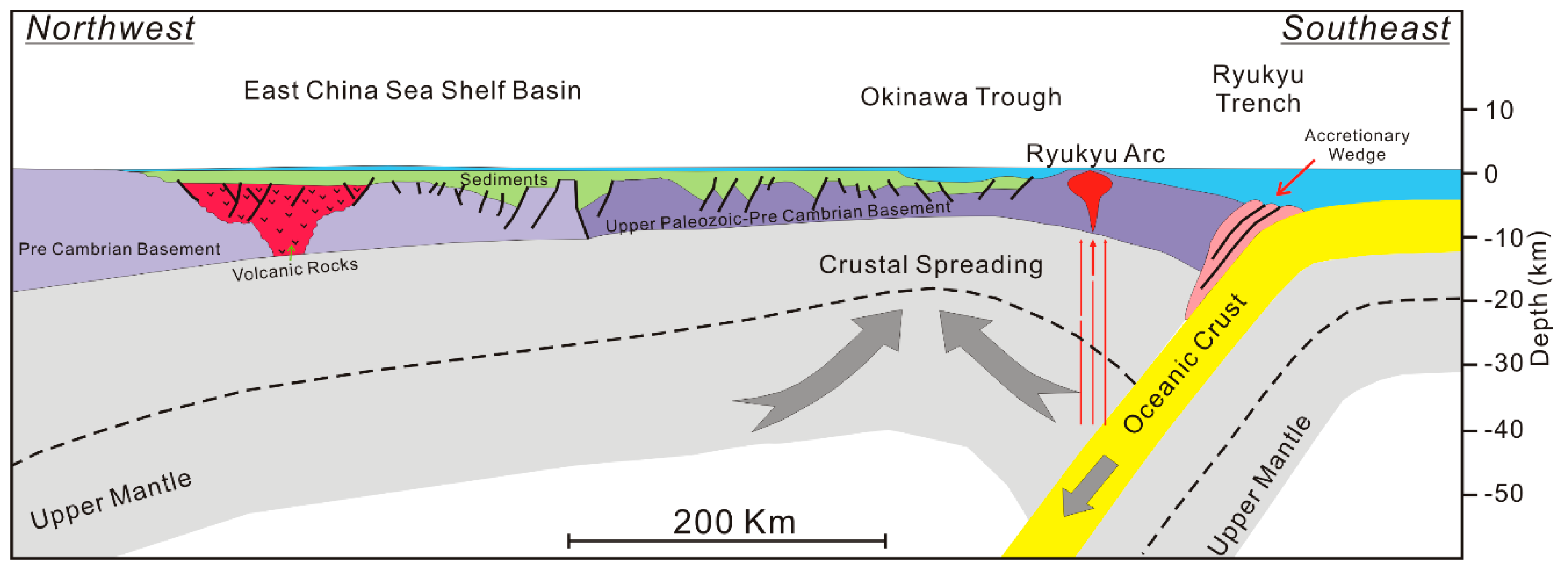
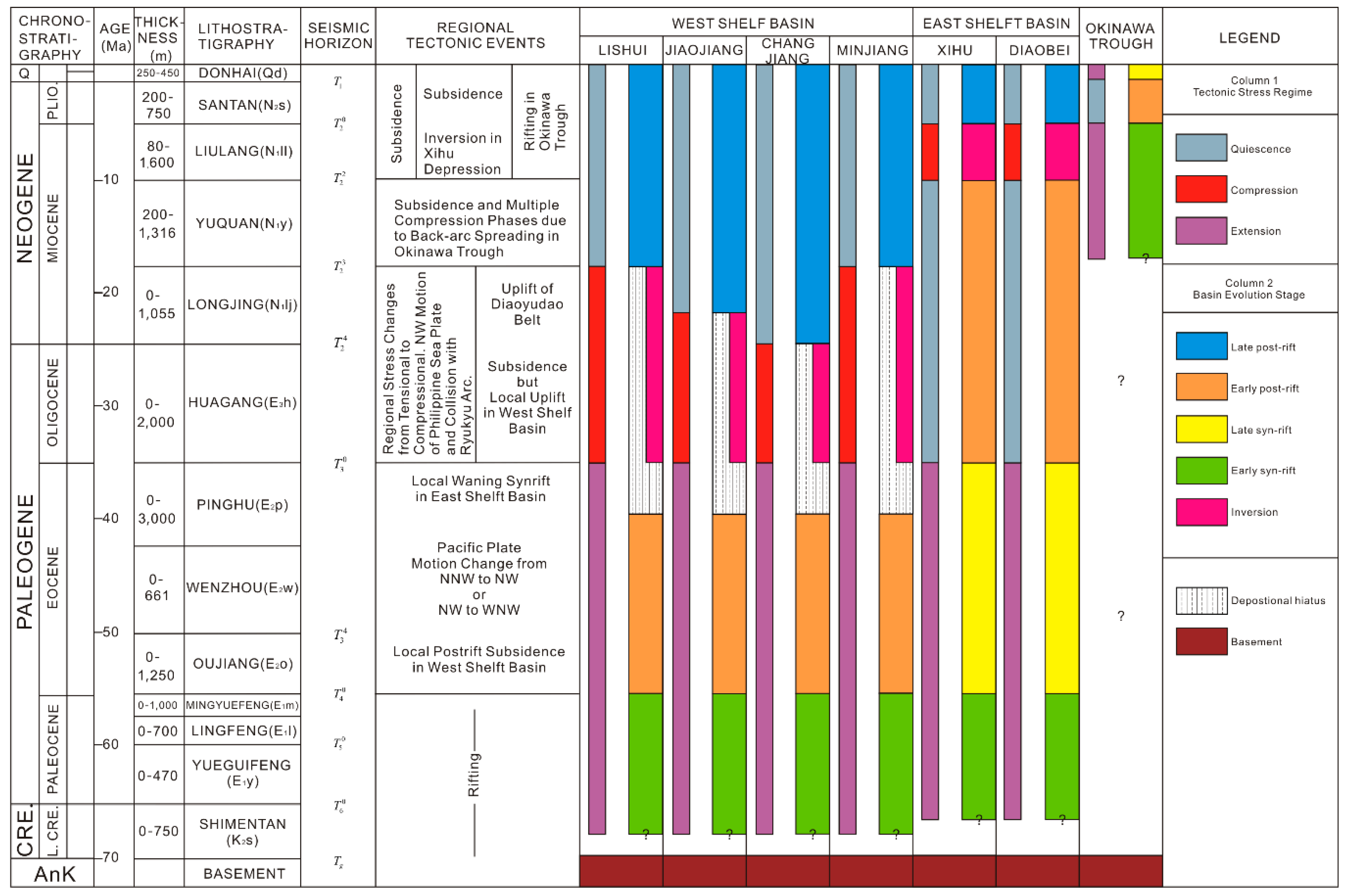
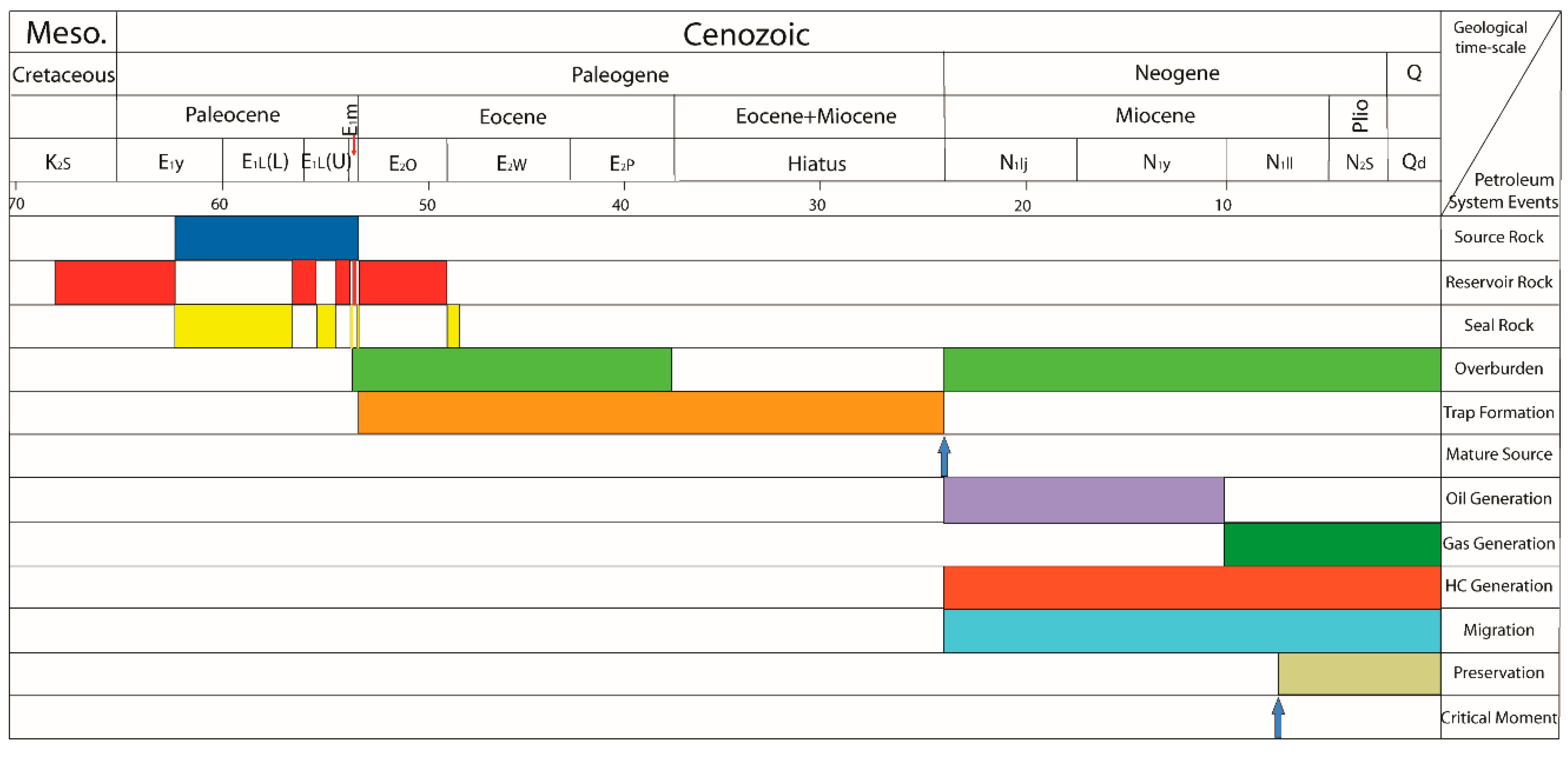
3.1. Tectonic Evolution

The East China Sea Basin comprises a complex of back-arc basins located on extended continental crust close to the leading edge of the Eurasian plate. It lies west of the Ryukyu Trench, where the oceanic crust of the Philippine Sea plate is subducted below the Eurasian plate (Figure 2) [24].
The tectonic evolution of the East China Sea Basin is still not fully understood. Most of the detailed studies focused on the Okinawa Trough and the Ryukyu Arc [25,26,27,28,29,30,31]. Plate tectonic reconstruction of the Far East generally concentrates around southeast Asia and the southwest Pacific, with the East China Sea being a peripheral area [32,33]. It is generally accepted that the tectonic evolution of the East China Sea Basin is controlled by the interaction of the Eurasian, Pacific, and Philippine Sea plates; however, the details of the relationship between basin development and the interaction of these three plates remain elusive.
Four main tectono-stratigraphic cycles are distinguished in the evolution of the basins [1,24,34,35,36,37,38]. It is important to note that these cycles are not time-equivalent throughout the area (Figure 3).
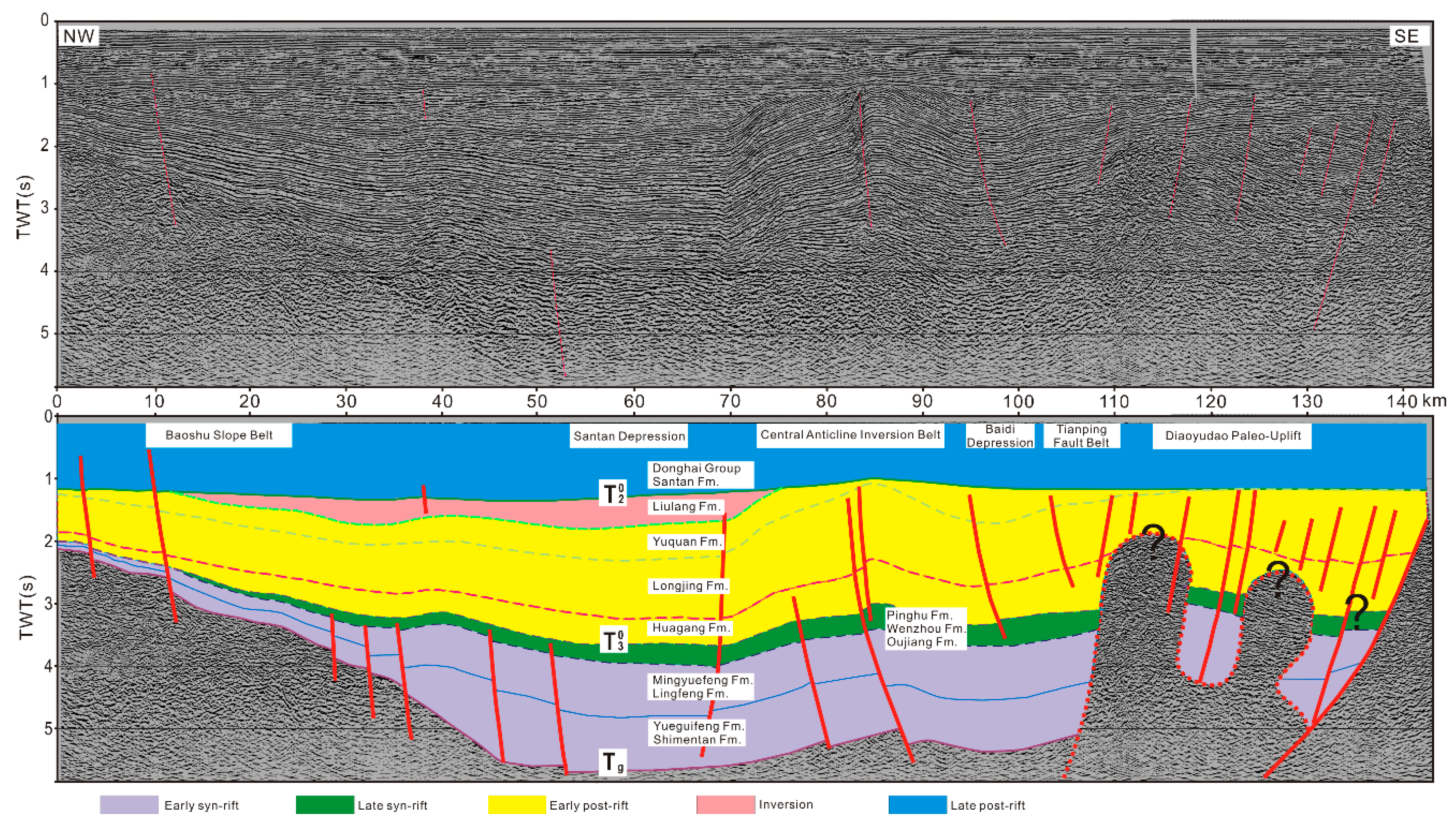
  • A rift cycle (Late Cretaceous to Paleocene), during which active back-arc extension was accompanied by active normal faulting and the accumulation of mainly deltaic to marine clastic sediments in rift grabens.
  • An early (or first) post-rift thermal sag cycle (Eocene to Oligocene), during which mainly deltaic and marginal marine sediments accumulated. There was less faulting during this cycle, and the depositional areas extended over large parts of the rift shoulders.
  • An inversion cycle (Oligocene to Miocene), when compression affected the syn- and post-rift sequences, forming uplifted ridges in the basins. Uplift was accompanied by erosion and local deposition
  • A late (or second) period of post-rift thermal sag cycle (Miocene to Quaternary), during which active extension and faulting shifted to the Okinawa Trough.
Many Late Mesozoic to Tertiary rift–post-rift basins in eastern China and southeast Asia follow a similar evolutionary history of cycle development. Doust et al. [18], for instance, recognized early and late syn- and post-rift cycles, interrupted by local inversion periods. In the next section, the evolution of the cycles is examined in more detail.
The tectonic evolutionary history of the East China Sea Basin (Figure 3) is described below.
The rift cycle: The East China Sea Basin was formed by faulting during the Late Cretaceous to Paleocene, with the development of half-grabens under (trans)tensional stresses. The initial collision of India with Eurasia resulted in the closure of the Tethys, and the southeastern Eurasia continental margin was pushed eastward along pre-existing major faults. In the east, the Pacific plate changed direction from north to northwest, placing the Eurasian continental margin under a transtensional regime, and the East China Sea Basin probably developed as a complex area of pull-apart rift basins [1,36]. In the West Shelf area, rifting ceased at the end of the Paleocene, but it continued in the East Shelf Basin to encompass the Eocene.
The first post-rift thermal sag cycle: This corresponds to the Eocene in the West Shelf Basin and was brought to an end by a short period of uplift in the Oligocene. Post-rift conditions, on the other hand, did not reach the East Shelf basins until the Oligocene. The collision between India and Eurasia continued during the Late Eocene–Oligocene; however, at the end of Eocene, the Pacific plate changed its relative direction of movement from north-northwest (NNW) to northwest (NW) [33] or NW to west-northwest (WNW) [1], becoming more perpendicular to the Eurasian continental margin. This is marked in the East China Sea Shelf Basin by the uplift and erosion of the Diaoyudao Paleo-uplift, and an eastward shift of the depo-centers to the Xihu and Diaobei sub-basins.
The inversion cycle: By the end of the Oligocene/Early Miocene period, the northwestward subduction of the Philippine Sea plate affected the southern part of the East China Sea Basin, whereas the northern East China Sea Basin was affected by the Pacific plate subduction. Related inversions were accompanied by a hiatus in the Oligocene in the West Shelf Basin, but only affected the Eastern Shelf in the Late Miocene. By Middle Miocene, the Xihu Sub-basin depositional trend shifted from southeast to northeast. The cause for this shift is not known; however, it is speculated that it is related to the northeastward migration of the Philippine Sea plate, early development in the North Okinawa Trough, and the opening of the Japan Sea to the north. At the end of the Middle Miocene to early Late Miocene, the northwestward subduction of the Philippine Sea plate increased, resulting in the development of the trench–arc–back-arc basin system (Ryukyu Trench–Ryukyu Arc–Okinawa Trough) on the basement, east of the East China Sea Basin. The Xihu Sub-basin underwent compression, and high-relief anticlines were developed mainly on the eastern flank of the sub-basin. This Miocene compression appears to be confined to the Xihu sub-basin. In the Diaobei Sub-basin to the south, there are only a few gentle anticlines with no associated reverse faults [37].
The second post-rift thermal sag cycle: This cycle commenced in the Miocene in the west and in the Pliocene to the east. Although the Philippine Sea plate subduction beneath the Eurasian plate continued, it appears to have mainly affected the Okinawa Trough (which probably commenced its syn-rift cycle at this time) and the Ryukyu Arc. Most of the rest of the East China Sea Shelf Basin underwent a period of regional sag. The rifting in the Okinawa Trough took place in two phases, and the Pliocene brought about a time of relative calm in terms of extensional tectonics (Figure 3) [28].
The tectonic evolutionary history of the Okinawa Trough according to References [24,34,35] is described below (Figure 3).
The first syn-rift cycle (Middle Miocene–Late Miocene): During this time, the first phase of rifting and volcanism occurred. The basement began to fragment with rapid subsidence occurring along major faults, which also defined the shape of the Okinawa Trough.
The post-rift thermal sag cycle (Pliocene): The Pliocene brought about a time of relative calm in terms of extensional tectonics. Initial thinning of the crust in the back-arc was followed by a period of rapid thermal subsidence to equilibrate isostatic imbalance. The overall effect was the development of large volumes of accommodation space. By the late Pliocene, subduction is thought to have slowed [35]. Volcanic activity at this time was probably reduced to a minimum.
The second syn-rift cycle (Quaternary): In the Early Pleistocene came a second major phase of rifting and volcanism, which is still active today. Fault scarps exposed on the seabed illustrate the current activity.
From the above, it is evident that the West and East Shelf basins passed through similar tectono-stratigraphic cycles, albeit at slightly different times, possibly resulting from extended periods of active subsidence and subduction roll-back along the Ryukyu arc. In this context, Uyeda et al. [39] introduced two possible subduction models depending on the type of stress field under which the opening of the back-arc (sub-)basins took place (Figure 4). Compressional stress regimes in the back-arc region may occur if there is a relatively high-speed “shallow-slab” subduction (Figure 4, top), whereas tension stress regimes characterize the back-arc region when the subducting slab is relatively dense and steeply dipping (Figure 4, bottom). During the Cenozoic tectonic evolution of the back-arc East China Sea Basin, extension and compression events alternated with each other, and it is speculated that phases of relative high-speed subduction of the Philippine plate are associated with inversion processes, while phases of relative low subduction rate characterize the rifting periods.
A 2002 study by van Wijk [40] provided a possible mechanism via which both rift migration resulting from shifting of the main locus of extension and local uplift could result from variable stretching rates during one lithospheric extension episode. In the East China Sea Basin, rifting started in the West Shelf Basin and moved to the Okinawa Trough via the East Shelf Basin (Figure 3). These rift zones formed respectively during the Cretaceous–Paleocene–Eocene episode (70–40 Ma), the Cretaceous–Miocene episode (70–5 Ma), and the Mid-Miocene–Quaternary episode (18–0 Ma), and extended in the northeast (NE)–southwest (SW) direction. The time gap between the successive rifting events was ~13–30 Ma. A striking feature of van Wijk’s model is the related uplift in the original basins and re-thickening of the pre-thinned crust. In the East China Sea Basin, the uplifted structures, Yandang Low-uplift, Yushan Paleo-uplift, and Diaoyudao Paleo-uplift, located between the sub-basins, are consistent with such modeling results.

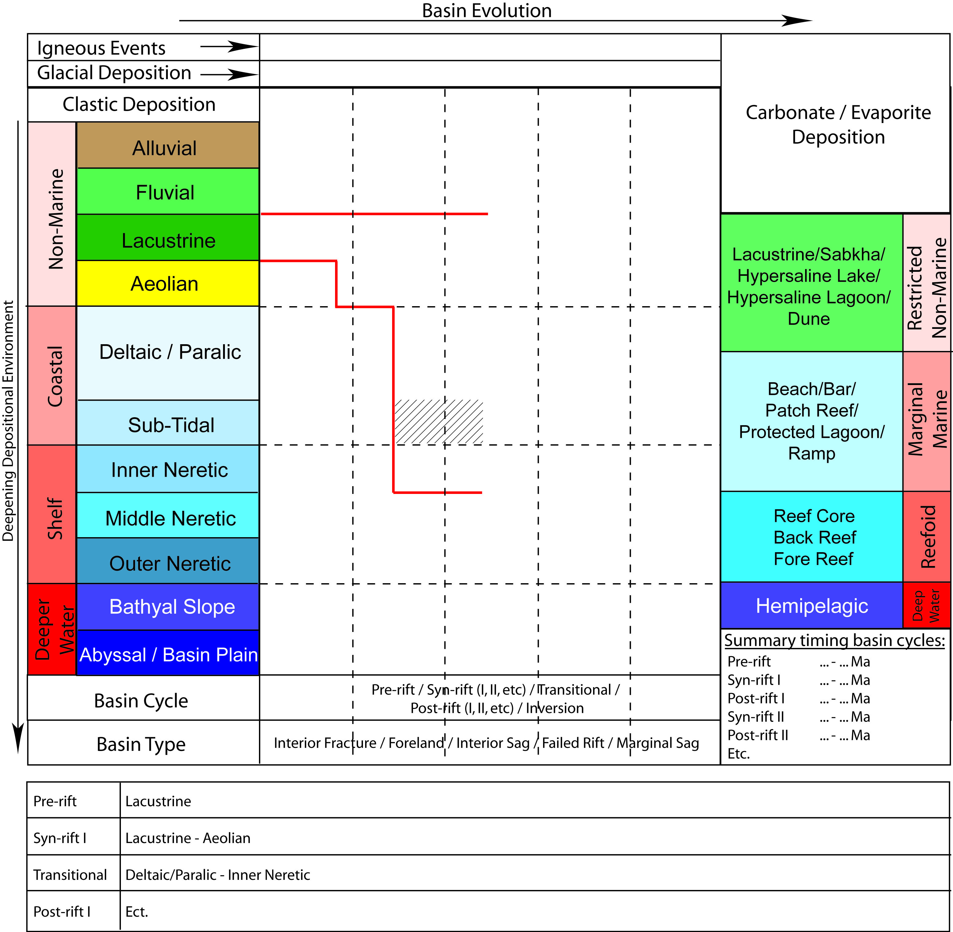
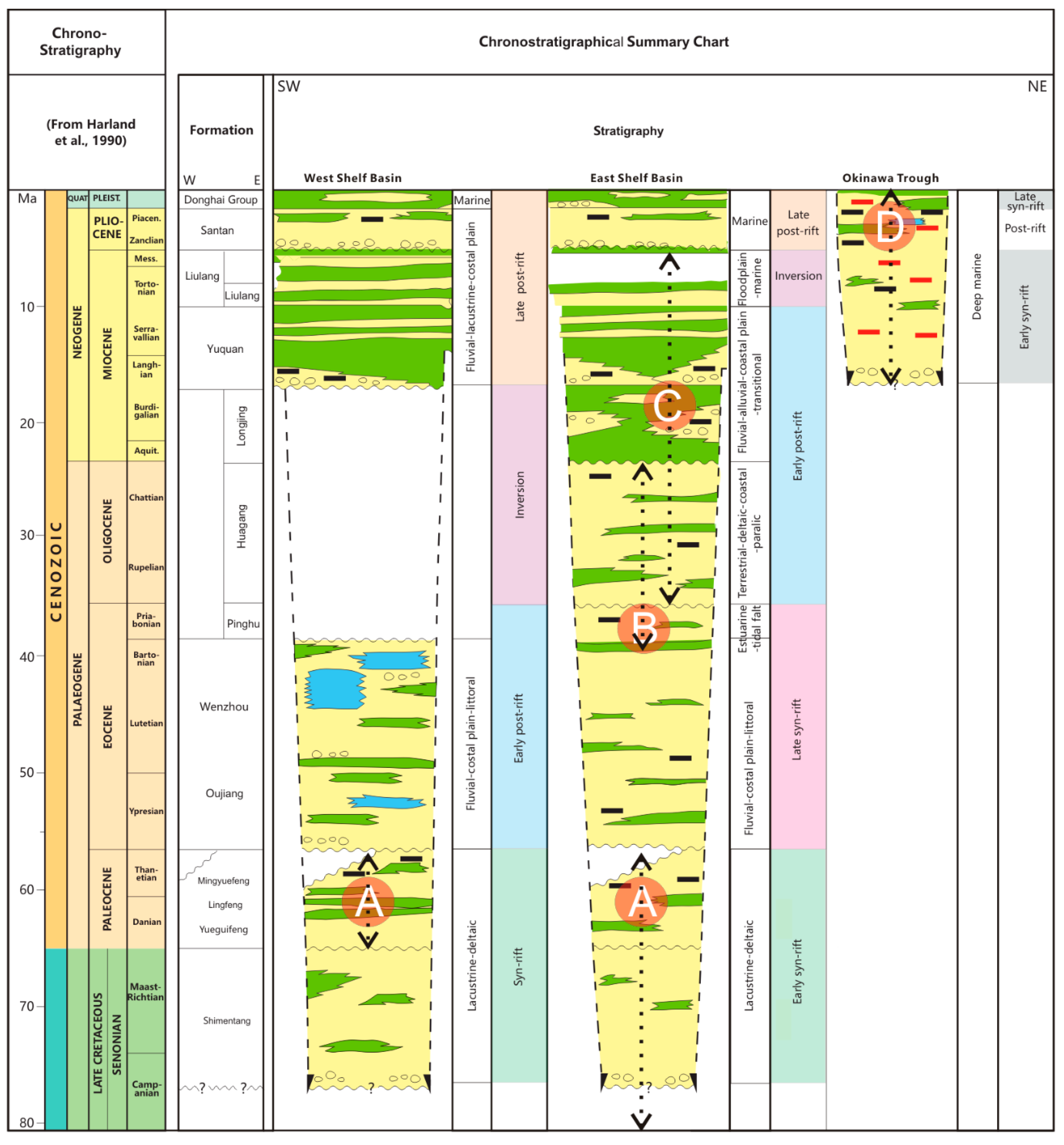
3.2. Sedimentary Facies Development

The basement of the East China Sea Shelf Basin consists of Proterozoic metamorphic rocks, believed to be part of the accreted complexes of eastern China, as well as Mesozoic volcanics and granite [1]. The Diaoyudao Paleo-uplift is a complex faulted and folded structure and consists of Paleogene–Lower Miocene sediments with welded tuffs and igneous intrusions of Miocene age and remnants of arc volcanism. The Diaoyudao Paleo-uplift is also called the Taiwan–Sinzi fold belt. During the opening of the Okinawa Trough, compression adjacent to the spreading center triggered uplift in this zone, probably at about mid-Miocene time. The Diaoyudao Paleo-uplift has a thin sediment cover lying on top of basement believed to comprise Late Paleozoic–Late Mesozoic granitoids or volcanic intrusions. The sediments of the Okinawa Trough become younger and thinner from north to south. In the north late Miocene to Quaternary, sediments have a thickness of up to 8 km, while, in the south, thickness is reduced to 3–4 km of Pliocene to Quaternary sediments.
Lambiase et al. [41] studied the depositional models for syn- and post-rift stages of rift basins. The below discussion of the sedimentary history of the East China Sea Shelf Basin is based on [1,36,42]. The sedimentary sequences of the East China Sea Shelf Basin are ascribed to five stages in basin evolution (Figure 5), as discussed below.
Early syn-rift (Late Cretaceous to Paleocene): During the syn-rift phase, active faulting resulted in the formation of half-grabens developed both in the western shallow sub-basin area and in the eastern deep sub-basin area. These half-grabens were filled with lacustrine–deltaic clastic sediments, but were interrupted by periods of marine transgression starting in the Late Cretaceous. During the Paleocene, the East China Sea Shelf Basin became progressively more marine, with the sea invading from the southeast. The syn-rift sediments, the Shimentan, Yueguifeng, Lingfeng, and Mingyuefeng formations, were penetrated by wells in the western shallow depressions of the West Shelf Basin. The Paleocene Yueguifeng Formation, which forms a lacustrine sequence, is composed of two sedimentary cycles with a gross thickness of up to 470 m. The upper cycle contains more sands with coarser grain sizes than the lower. It is in unconformable contact with the Cretaceous Shimentan Formation. The Paleocene Lingfeng Formation, which comprises a littoral–neritic sequence, is composed of up to 700 m of primarily gray, dark-gray, and black claystones with interbedded thin-layered, light-gray calcareous siltstones, fine sandstones, and occasional thin-layered calcareous fine sandstones. The Paleocene Mingyuefeng Formation is composed of a regressive sequence, having a thickness of up to 1000 m, and contains coal beds that were deposited in a delta-plain environment. There is an angular unconformity at the top of the Mingyuefeng Formation [13].
Late syn-rift (Eocene): During the later syn-rift phase, deep depo-centers were formed in the eastern parts of the area. These depo-centers, Xihu and Diaobei, received more than 7 km of late syn-rift sediments (Oujiang, Wenzhou, and Pinghu formations) during the Eocene. In the western sub-basins, up to 2 km of late syn-rift sediments were deposited in some places. The Eocene Oujiang Formation is composed of a fluvial–littoral sequence, has a thickness of up to 1250 m, and contains light-gray and gray claystones in the upper part and primarily light-gray and gray fine–medium-grained sandstones in the lower part. It is in conformable contact with the Eocene Wenzhou Formation, which has a thickness of up to 661 m and is composed of coastal plain–littoral facies. It consists of a coarsening upward sequence with coal near the top [13]. The Eocene Pinghu Formation is predominantly claystone, intercalated siltstone, and coal with a thickness of up to 3000 m, deposited in estuarine and tidal flat environments. It unconformably overlies the Wenzhou Formation [2].
Overall, the East China Sea Shelf Basin was tilted to the southeast and east-southeast, and many authors [8,9] agreed that the southern portion was under shallow marine conditions during the Eocene when the northern portion was still under terrestrial–coastal plain–paralic conditions.
Early post-rift (Oligocene–Middle Miocene): During the Oligocene, the West Shelf Basin was uplifted, and sediments (Huagang Formation) were deposited mainly in the eastern part of the basin. Terrestrial–deltaic–coastal conditions prevailed in the north (Xihu) and paralic conditions in the south (Diaobei). By the end of Oligocene/Early Miocene time, uplift of the Diaoyudao Paleo-uplift commenced. It is marked by a strong unconformity and combined with a northeast tilt of the Xihu Depression. This created increased accommodation space in the northern half of the Xihu Sub-basin during the Early–Middle Miocene. The Miocene sediments (Longjing and Yuquan formations) consist of fluvial–alluvial and coastal plain deposits, with marine incursions to the northeast. The Diaobei Sub-basin continued to tilt toward the southeast, and the sediments were probably deposited in a transitional setting. The Oligocene Huagang Formation is composed of siltstone and claystone in the lower part and sandstone with interbedded claystone and coal seams in the upper part, and it has a thickness of up to 2000 m. Overlying the Huagang Formation is the Miocene Longjing Formation with a thickness of up to 1055 m. In the lower part, it consists of sandy conglomerate and/or conglomeratic sandstone intercalated with claystone, and, in the upper part, it consists of siltstone with interbedded claystone and coal [44]. The Miocene Yuquan Formation, lying conformably above the Longjing Formation, consists of sandy conglomerate and/or conglomeratic sandstone, siltstone, claystone, and coal with a total thickness of 200–1316 m.
Inversion/compression (Late Miocene): During the Late Miocene, the westward subduction of the Philippine Sea Plate accelerated [45,46]. This is manifested in the Xihu Sub-basin by increased compression and uplift, starting from the end of Middle Miocene in the south and migrating and intensifying northeastward by the end of Late Miocene. This marks an erosional cycle, during which, however, local floodplain–marine coarse syn-inversion clastics belonging to the Liulang Formation accumulated on the flanks of the inversions in the East Shelf Basin. In the meantime, the fluvial and lacustrine Liulang Formation was deposited conformably above the Yuquan Formation in the West Shelf Basin. The Miocene Liulang Formation consists of 80–1600 m of siltstone and claystone [44].
Late post-rift/regional sag (Pliocene–Quaternary): The end of the compression phase (basin inversion phase) is marked by a top Miocene unconformity, and it was followed by a regional transgression during the Pliocene accompanied by renewed thermal subsidence without significant compression or extension, particularly in the Xihu Sub-basin. The Pliocene Santan Formation is composed of 200–750 m of marine claystone, silty claystone, argillaceous siltstone, and sandstone. It is in angular unconformable contact with the underlying Miocene Liulang Formation. The youngest sediments in the basin are those of the Pleistocene Donghai Group composed of 250–450 m of unconsolidated marine siliciclastic sediments [13,44].
The sedimentary fill of the Okinawa Trough is rather less well explored, mainly due to the fact that correlation and extrapolation are extremely difficult. Neogene outcrops are almost entirely absent on the Ryukyu Arc, and deep-water drilling is extremely sparse with only one deep exploration well, To-Ka-1, drilled in the Okinawa Trough by Shin Nishi Nihon Sekiyu Kaihatsu K.K. in 1978 [47]. The well penetrated the altered Cretaceous granodiorite basement overlain by Miocene to Quaternary sediments. Lithologies consist of thick, predominantly fine-grained turbiditic siliciclastics resting upon marine Middle Miocene volcanics. The siliciclastics are composed of deep marine silty claystones, which coarsen upward into shallow marine marls, clays, fine silts, and quartz-rich sandstone.
The tectono-stratigraphic evolution of the basins is summarized at the end of this article.

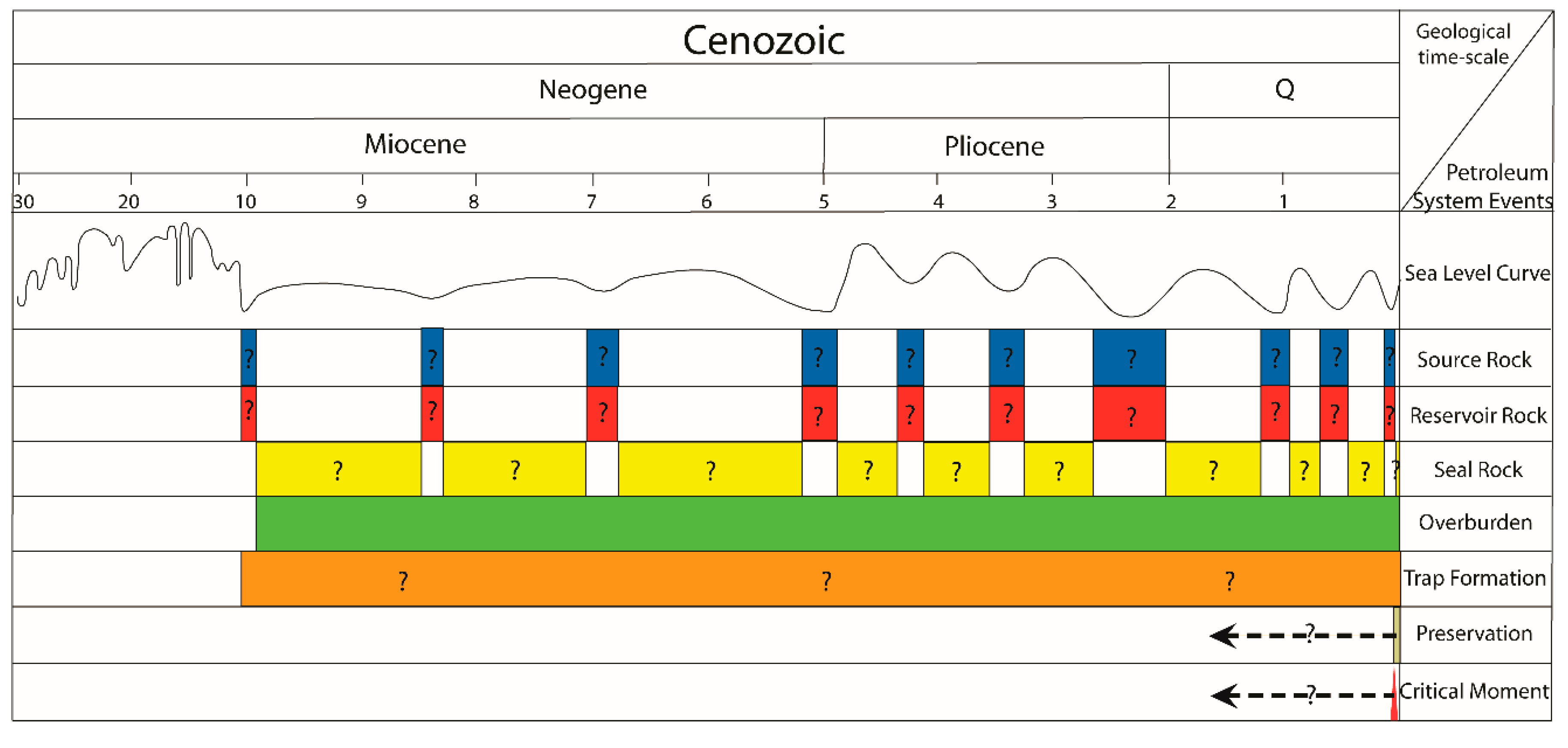
4. Petroleum Systems and Play Developments

Using the geological background described above as a base, the petroleum systems and plays in the East China Sea basins were investigated. Two major sub-basins, Xihu and Lishui, typically representing the East Shelf Basin and the West Shelf Basin, respectively, are discussed and studied below in detail.

4.1. Petroleum System Types (PSTs)

Within the East China Sea Basin, it is proposed that four types of petroleum system, linked to stages in basin evolution (Figure 5), may be represented. These are either proven (!) (i.e., they are represented by petroleum fields) or speculative (?) (i.e., it is believed they could be present based on the study). In the proven PSTs, it is noted that, in some (category i), both source rock and main reservoir lie within the same basin cycle (i.e., the petroleum system is integral to that cycle), while, in others, the reservoir may lie in another, usually younger, basin cycle than the source rock (category ii).

4.1.1. Early Syn-Rift Lacustrine–Deltaic PST (PST A)

This PST is common in the West Shelf Basin and is relatively oil-prone due to widespread development of reportedly organic-rich type II source rocks of lacustrine–deltaic origin [5]. In the East China Sea basins, in general, the lacustrine facies appears to differ from that found in southeast (SE) Asian Tertiary basins, where more tropical conditions prevailed and where rich type I source rocks are common [18]. Within the upper part of the Paleocene sequence, relatively less developed gas-prone shallow marine type III source rocks can also be found. Reservoirs are shallow marine, lacustrine–deltaic sandstones with minor Precambrian fractured gneiss basement in the pre-rift fault blocks. Paleocene intra-formational claystones represent local seals in the West Shelf Basin. This PST was proven in the western sub-basins.
The petroleum systems identified or proposed to be represented by this PST are the following:
Yueguifeng–Lingfeng Petroleum System (!) (i.e., Lishui Sub-basin, other sub-basins of West Shelf Basin) Category (i);
Cretaceous/Paleocene–Basement Petroleum System (?) (i.e., Xihu Sub-basin, other sub-basins of East Shelf Basin) Category (ii).

4.1.2. Late Syn-Rift Marine PST (PST B)

Source rocks in this principally marine claystone sequence contain mainly gas-prone, type III kerogen with minor type II kerogen. The main reservoirs comprise shallow marine tidal channels, fluvial–deltaic distributary channels, and river-mouth-bar sandstones. In many sub-basins, this PST contains widespread regional seals in the form of thick Eocene–Miocene fluvial, lacustrine, and marine claystones. It was proven in the eastern sub-basins.
The petroleum system represented by this PST is the following:
Pinghu–Huagang Petroleum System (!) (i.e., Xihu Sub-basin, other sub-basins of East Shelf Basin) Category (ii).

4.1.3. Early Post-Rift Fluvial–Deltaic PST (PST C)

The major source rocks for this proposed fluvial–deltaic PST comprise type III gas-prone shallow marine coal-bearing claystones, good-quality sandstone reservoirs deposited in braided river and deltaic environments, and thick Eocene–Miocene fluvial, lacustrine, and marine claystone seals.
The anticipated petroleum systems that could be represented by this PST belong to category (i) and are the following:
Huagang–Huagang Petroleum System (?) (i.e., Xihu Sub-basin, other sub-basins of East Shelf Basin);
Miocene–Miocene Petroleum System (?) (i.e., Xihu Sub-basin, other sub-basins of East Shelf Basin).

4.1.4. Syn-Rift Marine Turbiditic PST (PST D)
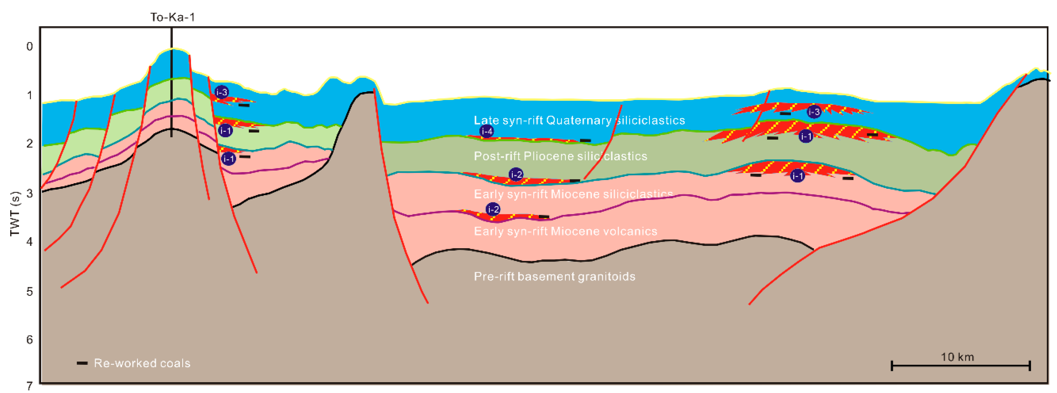
From observation of the tectono-stratigraphy, it is proposed that a speculative marine syn-rift turbiditic PST may be present in the Okinawa Trough. Even though a Pliocene post-rift thermal sag cycle was associated with the tectonic evolution of the Okinawa Trough, this relatively quiescent period took place against a background of continuing rifting.
The potential source rocks for this turbiditic PST would probably comprise type III gas-prone re-worked coal-bearing claystones. Neogene–Quaternary turbidite sands are likely to have good reservoir quality, and seals could be distal turbidites, basin-floor muds, and pelagic sediments.
The petroleum system that could be represented by this speculative PST belongs to category (i) and is the following:
Neogene/Quaternary–Neogene/Quaternary (?) (i.e., Okinawa Trough).

4.2. Xihu Sub-Basin

The Xihu Sub-basin is one of the key sub-basins and also one of the prime targets for hydrocarbon exploration of the East Shelf Basin. It is a NE–SW trending sub-basin, about 400 km long and 130 km wide (Figure 6), and it can be divided into five sub-units. These are, from west to east, the Baoshu Slope Belt, the Santan Depression, the Central Anticline Inversion Belt, the Baidi Depression, and the Tianping Fault Belt.
Most of the oil and gas discoveries are distributed along the Central Anticline Inversion Belt at the center of the sub-basin and along the Baoshu Slope Belt in the western part of the sub-basin. Figure 6 and Table 1 illustrate the locations and key features of the hydrocarbon fields.

4.2.1. Tectono-Stratigraphy

The Xihu Sub-basin evolved tectonically from a back-arc extensional rift basin to a passive margin post-rift (Figure 3 and Figure 7) through early syn-rift (Late Cretaceous–Paleocene), late syn-rift (Eocene), early post-rift (Oligocene–Middle Miocene), inversion (Late Miocene), and late post-rift (Pliocene–Quaternary) cycles. The inversion cycle compressional events were associated with structural growth and unconformities (Figure 5). The sedimentary formations and sediments deposited within each tectonic phase are shown in Figure 3 and Figure 5.

4.2.2. Petroleum System Development within Tectono-Stratigraphic Framework

In the Xihu Sub-basin, one proven petroleum system, the Pinghu–Huagang (!), is present, and three speculative petroleum systems, the Huagang–Huagang (?), the Cretaceous/Paleocene–Basement (?), and the Miocene–Miocene (?), were proposed [2,10,12].
PinghuHuagang Petroleum System (!): This is the most important petroleum system of the Xihu Sub-basin (Figure 8) and belongs to the late syn-rift marine PST (PST B). All currently discovered oil and gas fields and non-commercial hydrocarbon discoveries of the Xihu Sub-basin belong to this system (Table 1 and Figure 6).
• Source Rocks and Potential Source Rocks
Based on the samples from wells, Ye et al. [2] concluded that source rocks lie in dark claystone and coal of the Eocene Pinghu Formation, deposited in estuarine and tidal-flat environments. They typically contain type III gas-prone kerogen; however, because of the great thickness (average 628 m) of claystone, the presence of up to 28 m of coal, their basin-wide distribution and relatively high total organic carbon (TOC) content (average 1.31 wt.% and maximum 4.23 wt.% for the claystone and average 61.8 wt.% for the coal) (Table 2), they are likely to meet the standard as a source with good petroleum-generative potential [48]. Further geochemical data are not available, but the sequence is expected to form the most significant source rock, having reached a high level of thermal maturity (Ro = 1.30–2.20%) over most of the area [2]. Burial history modeling suggests that the Pinghu Formation entered the oil-window during the Early Miocene and is presently in the high-maturity stage.
• Reservoir Formations
The reservoirs are predominantly fine-grained sandstones and siltstones of the Huagang and Pinghu formations, deposited in fluvial–deltaic environments (Table 1 and Figure 5). The measured porosity values range from 10% to 35%, and the measured permeability ranges from 1 to 4000 mD [2].
• Seals
Fluvial–deltaic–littoral claystones of the upper Huagang Formation serve as a regional seal within the sub-basin, whereas local seals are present in the Longjing Formation. The overburden includes Oligocene to Quaternary marine sediments.
• Trap Formation
The principle traps are structural, including inverted anticline, fault, fault block, and reverse fault types, sometimes with a limited stratigraphic element, as, for example, where facies change is present (a detailed description of the trap types is given by Lee et al. [49]). The structural traps were formed between the Late Eocene and Miocene with the critical moment occurring around 7.0 Ma, close to the end of the Miocene.
Huagang–Huagang Petroleum System (?) (Figure 9) belongs to the early post-rift fluvial–deltaic PST.
• Source Rocks and Potential Source Rocks
These lie in fluvial–deltaic–littoral dark claystones and coals of the Huagang Formation. They contain typical gas-prone type III kerogen and have an average thickness of 358 m. The average and maximum TOC contents of the claystone are, respectively, 0.71 and 2.28 wt.% for the lower Huagang Formation, and 0.37 and 1.91 wt.% for the upper Huagang Formation (Table 2) [2]. The best potential occurs in the central and southern part of the Santan Depression and in the Baidi Depression (Figure 6), where generation, migration, and accumulation started in the Early Miocene and continues to the present day. In the northern part of the Santan Depression, the Huagang Formation reached a higher level of thermal maturity because of deeper burial.
• Reservoirs
The reservoir rocks are siltstones and sandstones of the Huagang and Longjing formations, deposited in fluvial–deltaic–littoral environments.
• Seals
The seals are fluvial–deltaic–littoral claystones of the upper Huagang and Longjing formations. The overburden rocks include Miocene to Quaternary strata.
• Trap formation
Trap types are similar to those of the Pinghu–Huagang Petroleum System (!). The trap development occurred from Oligocene to the end of Miocene and the critical moment was around 3 Ma.
Other speculative petroleum systems (?): In the Xihu Sub-basin, the Cretaceous/Paleocene–Basement Petroleum System (?) (early syn-rift lacustrine–deltaic PST) and the Miocene–Miocene Petroleum System (early post-rift fluvial–deltaic PST) (?) are identified as the other two speculative, but possible petroleum systems.
A single borehole studied by Xu et al. [50] shows that it penetrated into upper Paleocene rocks and contains abundant organic-rich dark claystone. These claystones are believed to be deposited in lacustrine–deltaic, littoral, and shallow marine environments. It is expected that the organic matter is highly mature (Ro = 1.30–2.20%) or overmature (Ro > 2.20%) for most of the sub-basin [50]. The Cretaceous/Paleocene–Basement Petroleum System (?) may occur locally along the Baoshu Slope Belt in the western part of the basin.
Although most Miocene potential source rocks are still immature because of their shallow depth of burial, any source rocks within the Longjing Formation of the northern Santan Depression may have reached the oil-window because of their relative deep burial depth and the associated higher geothermal gradient. Some oil was possibly generated and migrated from the Longjing Formation. Thus, a Miocene–Miocene Petroleum System (?) may exist in the northern Santan Depression and adjacent areas.

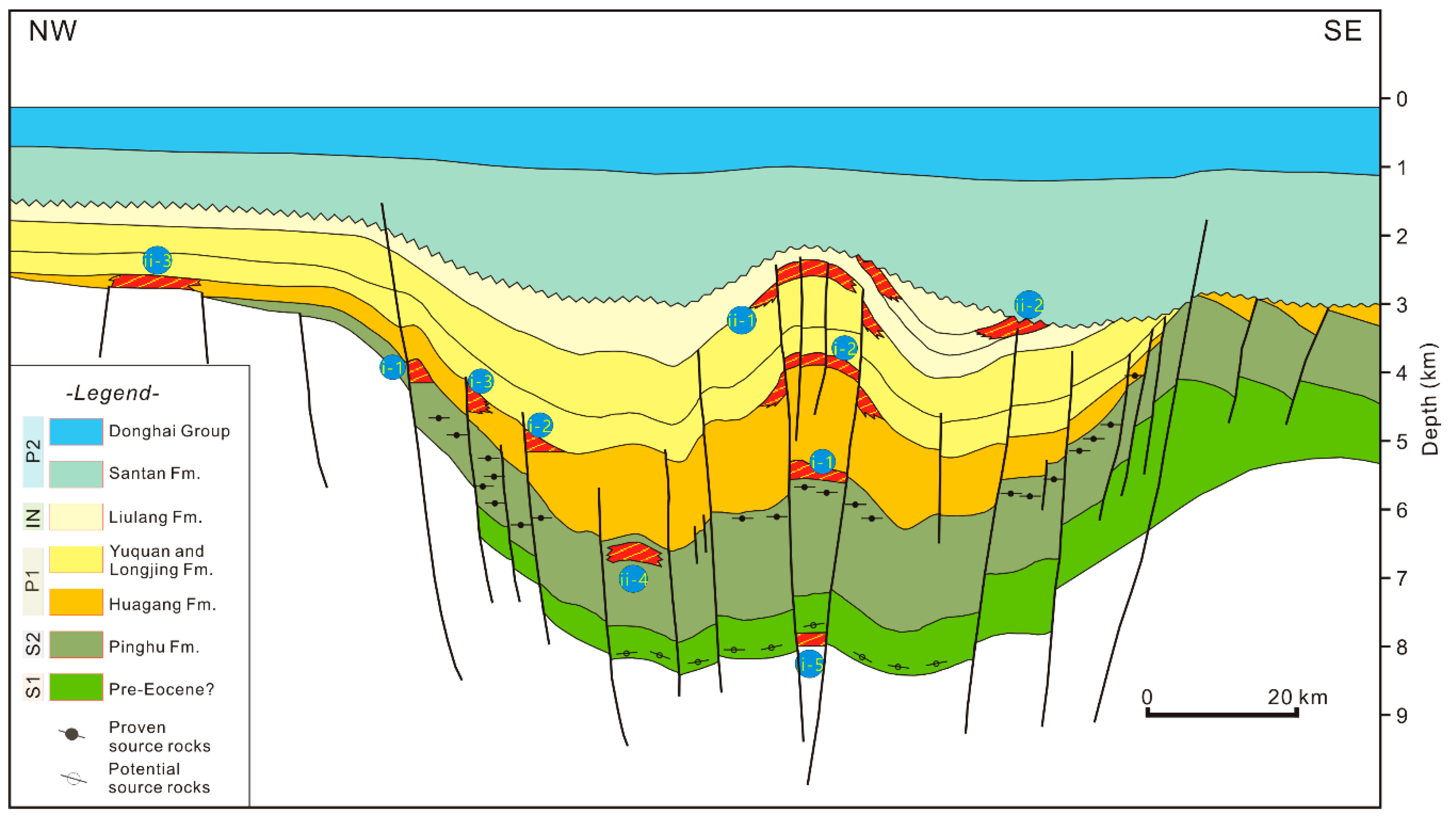
4.2.3. Play Development

Currently, a universally agreed definition for “play” does not exist. Doust [16] proposed a hierarchical definition of plays, in which a distinction is made between the petroleum charge characteristic, which is typically defined by the petroleum system, the play level, typically the formation or lithostratigraphic unit of the main reservoir horizons charged with hydrocarbons, and the trap style [21].
Plays present in the Xihu Sub-basin can be tabulated based on the trap types and identified play levels (Figure 10).
In proven plays, the main trap types and related fields include the following:
(1)
Pinghu structural (i-1), mainly inverted anticlines and fault bounded compressional hanging wall anticlines, represented by the Chunxiao, Duanqiao, Pinghu, Baoyunting, Wubei, Laiheting, and Kongqueting fields. This play type belongs to the Pinghu–Huagang Petroleum System (!).
(2)
Huagang structural (i-2), mainly inverted anticlines, reverse-fault related footwall closures and faults, represented by the Chunxiao, Tianwaitian, Duanqiao, and Canxue fields, as well as by the Gushan 1, Qiuyue 1, Yuquan, Huagang 1, Longjing 1, Longjing 2, and Longjing 4 discoveries. As above, this play belongs to the Pinghu–Huagang Petroleum System (!).
(3)
Huagang structural–stratigraphic (i-3), mainly fault-bounded closures with facies change, represented by the Pinghu and Wuyunting fields. This play also belongs to the Pinghu–Huagang Petroleum System (!).
For speculative plays, the main types are likely to include the following:
(1)
Miocene structural (ii-1) pop-up faulted anticlines, and stratigraphic (ii-2) sub-unconformity traps. Such plays could belong to the Miocene–Miocene Petroleum System (?).
(2)
Huagang stratigraphic (ii-3), sand pinch-outs on basin flank. Such a play might belong to the Huagang–Huagang Petroleum System (?).
(3)
Pinghu structural–stratigraphic (ii-4), mainly occurring in inverted anticlines. This play could belong to the Pinghu–Huagang Petroleum System (!).
(4)
Basement structural–stratigraphic (ii-5), porous basement in topographic relief. This play could be related to the Cretaceous/Paleocene–Basement Petroleum System (?).

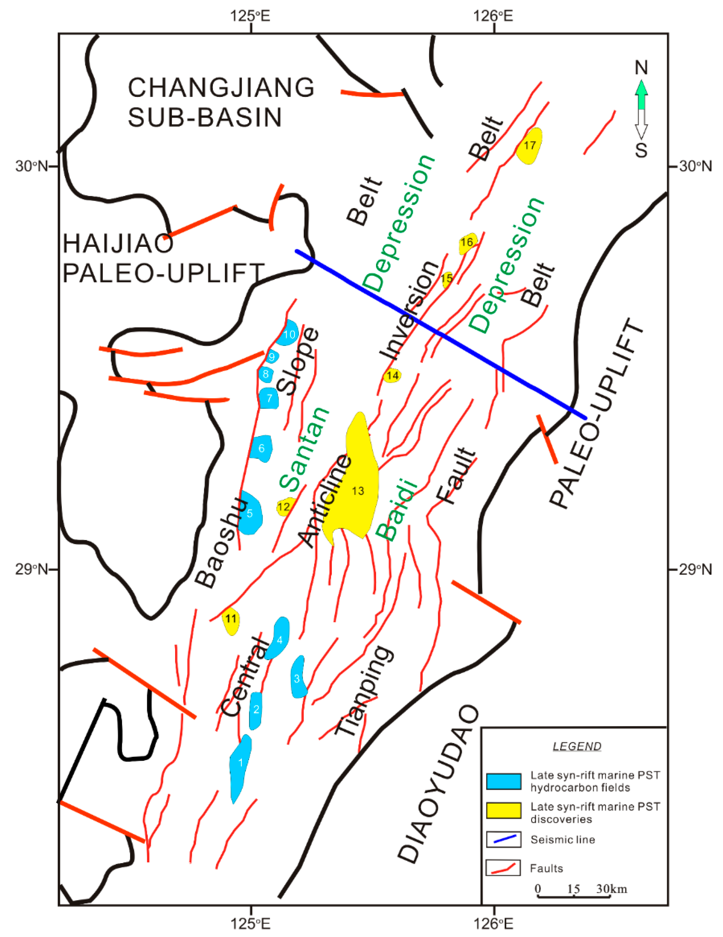
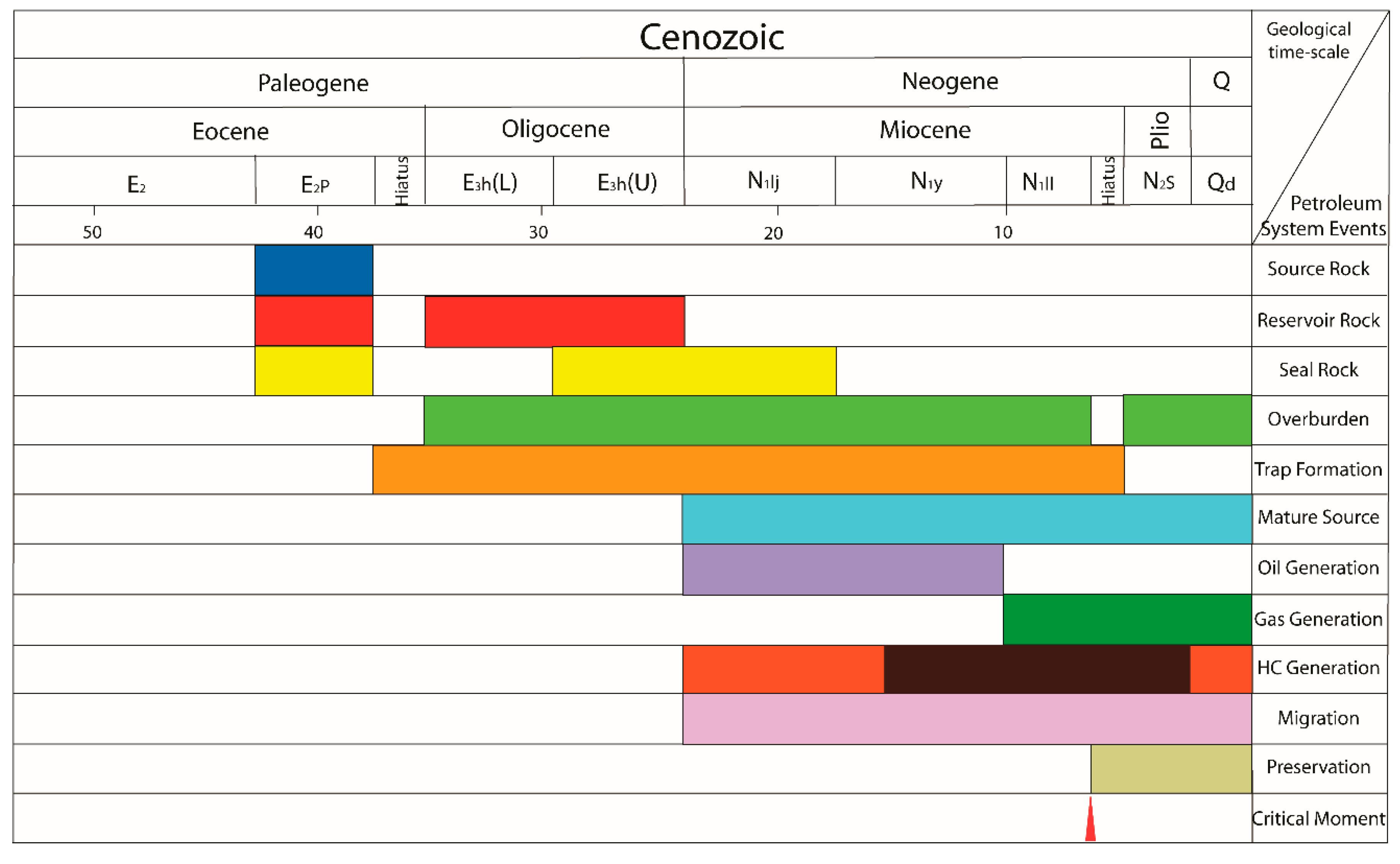
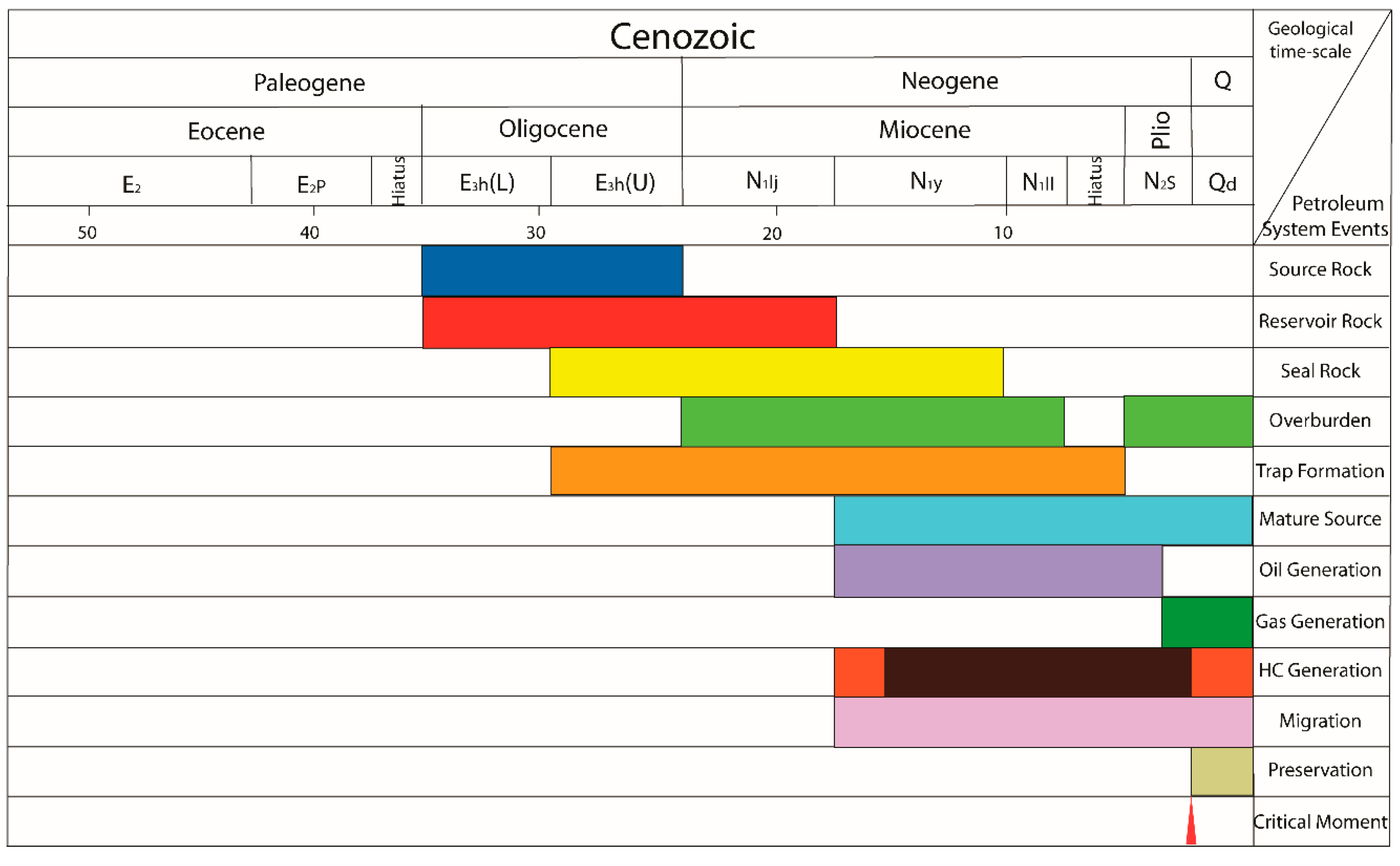
4.3. Lishui Sub-Basin

The Lishui Sub-basin, situated in the southwestern East China Sea is a faulted half-graben lying on Mesozoic basement with its main boundary fault on the eastern side. The sub-basin extends in a NE–SW direction and is divided into two depressions (Figure 11 and Figure 12). The East Depression has an area of about 4800 km2 and a maximum thickness over 7.5 km, while the West Depression covers an area of about 9800 km2 and a maximum thickness of 12 km.
Hydrocarbons were located in wells LF-1, LS 36-1-1, SMT-1, and WZ 13-1-1, but only the LS 36-1-1 gas field is of commercial value. Figure 11 illustrates the locations of the hydrocarbon fields and non-commercial hydrocarbon discoveries within the Lishui Sub-basin. Table 3 is a summary of key features of these fields and discoveries.

4.3.1. Tectono-Stratigraphy

The evolution can be summarized as follows based on the studies in References [6,13,51,52,53] (Figure 3, Figure 5, and Figure 12):
Early syn-rift (Late Cretaceous–Paleocene): The area was under tensional stress and active faulting controlled the deposition, which shows typical characteristics of fast subsidence with a maximum rate of 700 m/Ma. The sequence includes the Shimentan, Yueguifeng, Lingfeng, and Mingyuefeng formations.
Late syn-rift (Early–Middle Eocene): Fault activity waned in this stage and did not influence the sedimentation, which is characterized by a low subsidence rate. The Oujiang and Wenzhou formations were deposited at this stage.
Inversion (Late Eocene–Oligocene): During this period, most of the region was uplifted and eroded.
Post-rift (Miocene–Quaternary): Regional subsidence took place with a number of small faults being active. Deposits include the Longjing, Yuquan, Liulang, and Santan formations and Donghai Group.

4.3.2. Petroleum System Development within the Tectono-Stratigraphic Framework

Only one proven petroleum system, the Yueguifeng–Lingfeng (!) system, belonging to the early syn-rift lacustrine–deltaic PST, was identified.
YueguifengLingfeng Petroleum System (!): This is the most important petroleum system of the Lishui Sub-basin (Figure 13). All of the currently discovered oil and gas fields and non-commercial hydrocarbon discoveries in the Lishui Sub-basin belong to this system (Table 3 and Figure 11).
• Source rocks and potential source rocks
The source rocks lie in lacustrine claystones and coals of the Lower Paleocene Yueguifeng Formation with TOC contents of 1.16–4.08 wt.%, together with shallow marine claystones of the Upper Paleocene Lingfeng Formation with an average TOC content of 1.52 wt.%. Claystones and coals of the Upper Paleocene Mingyuefeng Formation may also form minor source rocks (average TOC content of 2.3 wt.% and a thickness of 120–200 m). The organic material is dominated by type II kerogen with minor type III and I kerogen. The locations of mature source rocks can be seen in Figure 11. Hydrocarbon generation, migration, and accumulation started during the Early Miocene and continues to the present day.
• Reservoirs and potential reservoirs
The reservoirs are dominated by fine-grained shallow marine sandstones of the Paleocene Lingfeng Formation with minor Precambrian fractured gneiss basement and shallow marine sandstones of the Mingyuefeng Formation and, potentially, the Eocene Oujiang Formation.
• Seals
The Paleocene intra-formational claystones of the Lingfeng and Mingyuefeng formations are effective cap rocks. Overburden rocks include Eocene, Miocene, Pliocene, and Quaternary sediments.
• Trap formation
In the Lishui Sub-basin, the major trap types are structural, including inverted anticlines, with a few combined structural–stratigraphic trap styles. The structural traps were formed during the Eocene and Oligocene inversion cycle. Thus, the critical moment of this system occurred at 8.0 Ma, close to the end of the Miocene.

4.3.3. Play Development
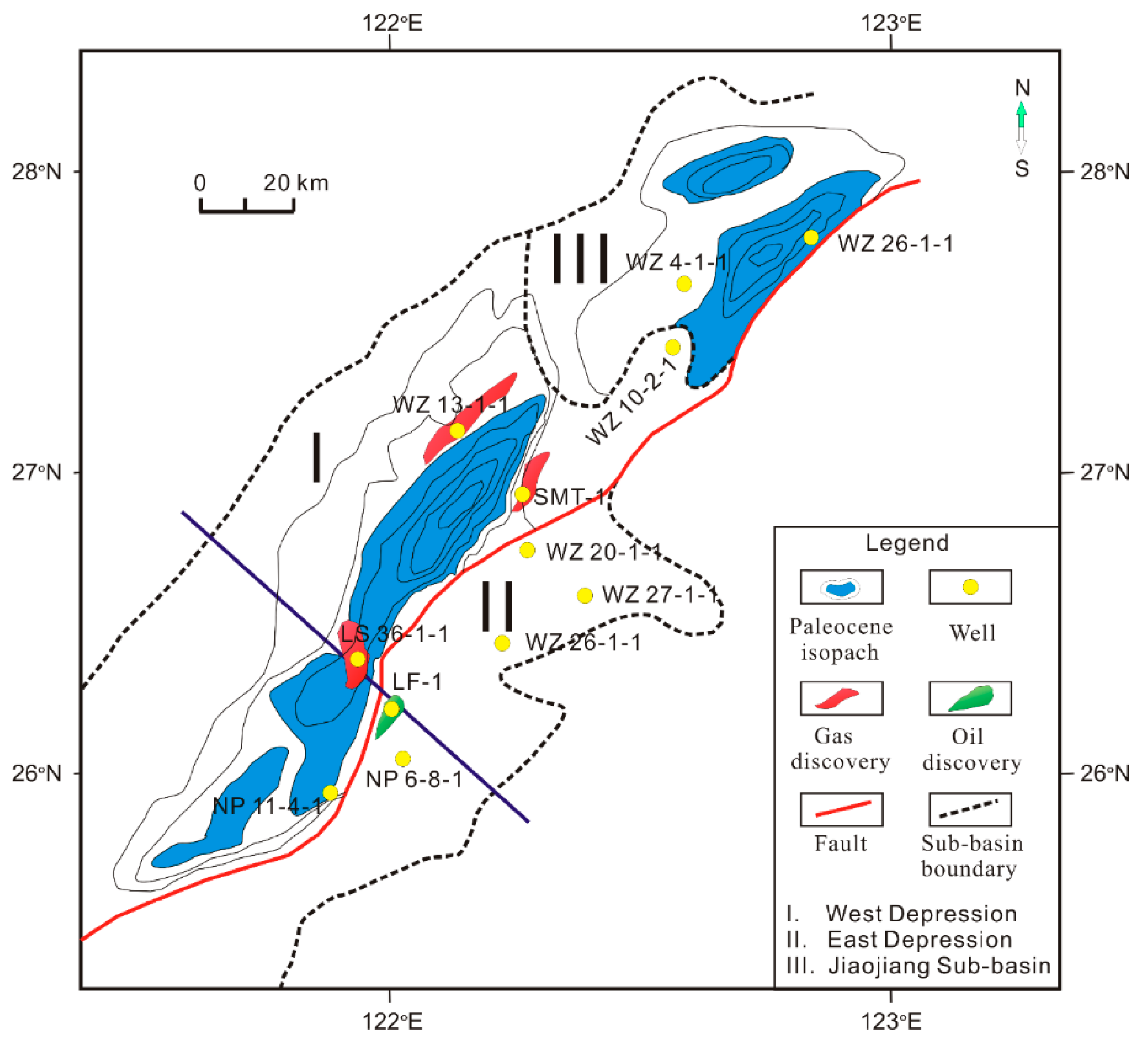
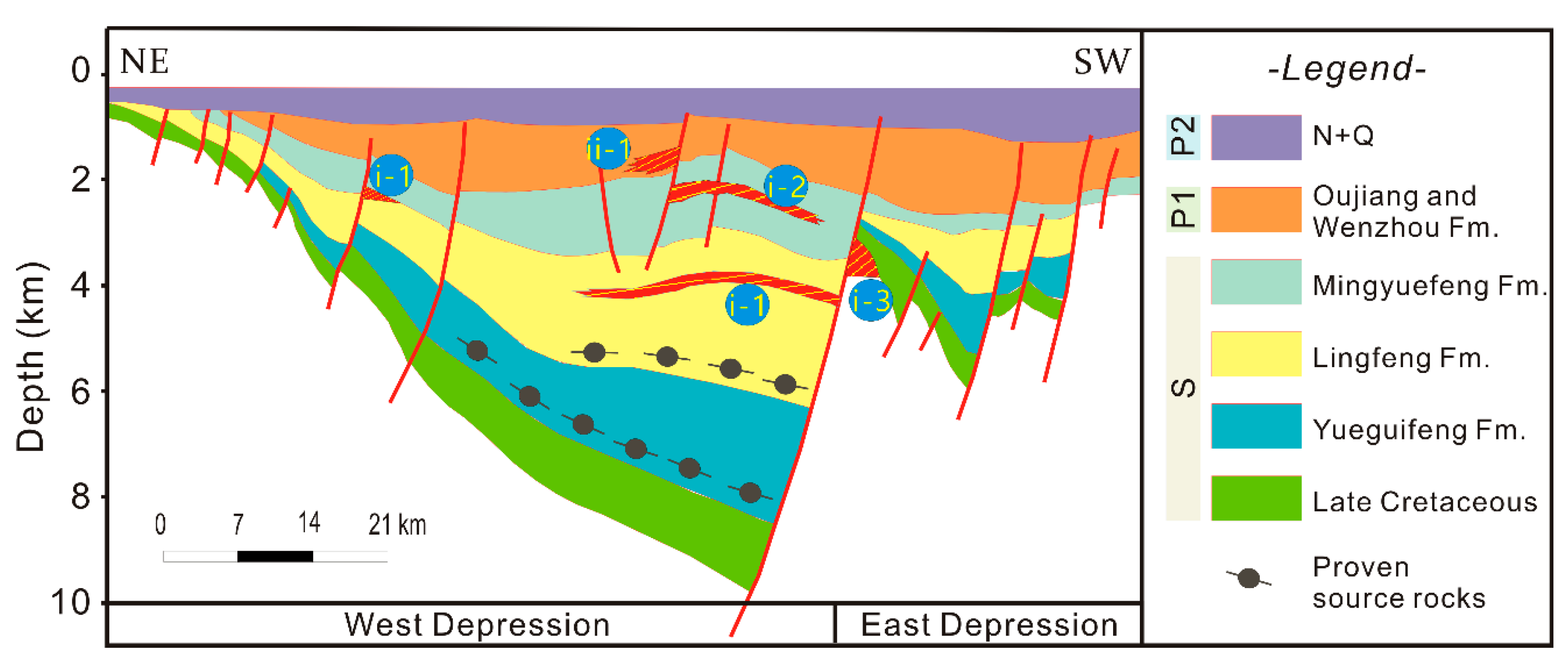
Three play or reservoir levels were identified in the Lishui Sub-basin. These are pre-rift basement, early syn-rift Paleocene Yueguifeng Formation, and (potentially) the late syn-rift Eocene Oujiang Formation.
The proven and speculative play types (Figure 12), all belonging to the Yueguifeng–Lingfeng Petroleum System (!), are summarized in below.
In proven play types, the main trap types include the following:
(1)
Lingfeng structural (i-1), mainly inverted anticlines and footwall closures, represented by the LS 36-1-1 field, and the WZ 13-1-1 and SMT-1 discoveries.
(2)
Mingyuefeng structural (i-2), mainly inverted anticlines, represented by the LS 36-1-1 field.
(3)
Basement structural–stratigraphic (i-3), porous basement in topographic relief, represented by the LF-1 discovery.
For speculative plays, the main trap types are likely to include the following:
(1)
Oujiang structural (ii-1), hanging wall fault blocks.

4.4. Okinawa Trough

The Okinawa Trough (Figure 1 and Figure 2) started to form in the Middle Miocene as a result of rifting between the Diaoyudao Paleo-uplift and the Ryukyu Arc [24,34]. By the end of the Late Miocene, a sedimentary basin was already developed [24,34]. With the opening of the Okinawa Trough, all extensional stresses being generated by subduction in the Ryukyu Trench became concentrated, and the active extension of the Xihu Sub-basin ceased at this time. At present, the Okinawa Trough is over 2 km deep and is generally considered to be a currently opening back-arc basin.
The sediments within the Okinawa Trough mainly consist of neritic and deep-water turbiditic volcaniclastics [24,27,34,35] (Figure 5). Typically, these rocks are regarded as having poor reservoir potential. Moreover, as a result of the recent opening of the Okinawa Trough as a back-arc basin, any potential source rocks are likely to be immature. In addition, a water depth of over 2 km is a major reason why petroleum exploration is yet to commence in this area.
In this section, the possibility that a petroleum system may be developed in this basin is speculated; furthermore, which source, reservoir/seal, and trap elements it could contain and, if present, which types of play could occur are also suggested. Such speculations rely on comparison with analogous basins in similar geologic situations (i.e., Takano [54]).

4.4.1. Tectono-Stratigraphy

Based on the studies in References [26,27,29,35,47,55], the evolution can be summarized as follows (Figure 3, Figure 5, and Figure 14):
Early syn-rift (Middle Miocene–Late Miocene): The first phase of rifting created the shape of the Okinawa Trough and strong volcanism resulted in a stratigraphy dominated by Middle Miocene volcanics and tuffaceous conglomerates followed by Late Miocene turbiditic siliciclastics.
Post-rift (Pliocene): After the initial stage of rifting, there was a period of quiescence where the basin subsided rapidly and uniformly. This subsidence plunged the trough into deeper and deeper water resulting in a rapid change from non-deposition to a deep-water depositional environment. By this time, sediments from the Yangtze River filled the East China Sea Shelf Basin and entered into Okinawa Trough, which was filled rapidly by deep-water turbidites.
Late syn-rift (Quaternary): The second major phase of rifting and volcanism is still active today. Overall continued subsidence and relentless input of sediment resulted in a rapidly filling basin.

4.4.2. Petroleum System Development within Tectono-Stratigraphic Framework

No petroleum system is proven to exist in the Okinawa Trough. The only petroleum system proposed here, the Neogene/Quaternary–Neogene/Quaternary (?) (Figure 15), is highly speculative and belongs to syn-rift turbiditic PST.
• Potential source rocks
Gas exploration in the Okinawa Trough concentrated on the identification of gas hydrate potential, and investigations by Japan Agency for Marine-Earth Science and Technology revealed methane seepage, as well as hydrothermal CO2 fields (http://www.jamstec.go.jp/chikyu/e/expedition/). Outcrops of the Oligo-Miocene on the Ryukyu islands contain coals, however, and it is possible that marginal quantities of gas-prone source rock may be present along the trend. The most likely occurrence would be in the form of re-worked coal-bearing clastics brought in by turbidites, similar to some of the source rocks in the shelf sub-basins. There were reports that C1–C5 gas was recovered from the To-Ka-1 well in the northern part of the basin; however, these cannot be confirmed by the authors. From the profile (Figure 14), this well appears to have been drilled on a very young structure, outside the main basin-deep.
• Potential reservoirs
Reservoir potential may exist in regressive delta-front and trough-fill turbidite sandstones in the shallower part of the sequence. The cyclicity of fluctuating Neogene sea levels [56] might provide an excellent natural mechanism for the development of reservoir-seal couplets in these sediments, particularly after the initial rifting event when there was a period of quiescence. Potential reservoirs could also include turbidite fans deposited at earlier stages during phases of rapid subsidence.
• Potential seals
Potential seals are probably widespread in thick basin-floor marlstone or claystone overlying the Miocene volcanics and in Pliocene transgressive intervals.
• Potential trap formation
Numerous trapping configurations, mainly structural, but possibly also stratigraphic, could have formed in this area of back arc extension. These could include localized inversion features related to the transtensional/transpressional tectonic environment created by the oblique subduction of the Philippine Sea plate beneath the Eurasian plate [46].

4.4.3. Play Development

It is envisaged that the following play types may be developed (Figure 14):
(1)
Neogene–Quaternary structural (i-1), such as footwall or hanging wall closures and inversion anticlines in normally faulted half grabens.
(2)
Neogene–Quaternary stratigraphic (i-2), resulting from facies changes along depositional dip, onlap onto structures, or drape over the existing structures.

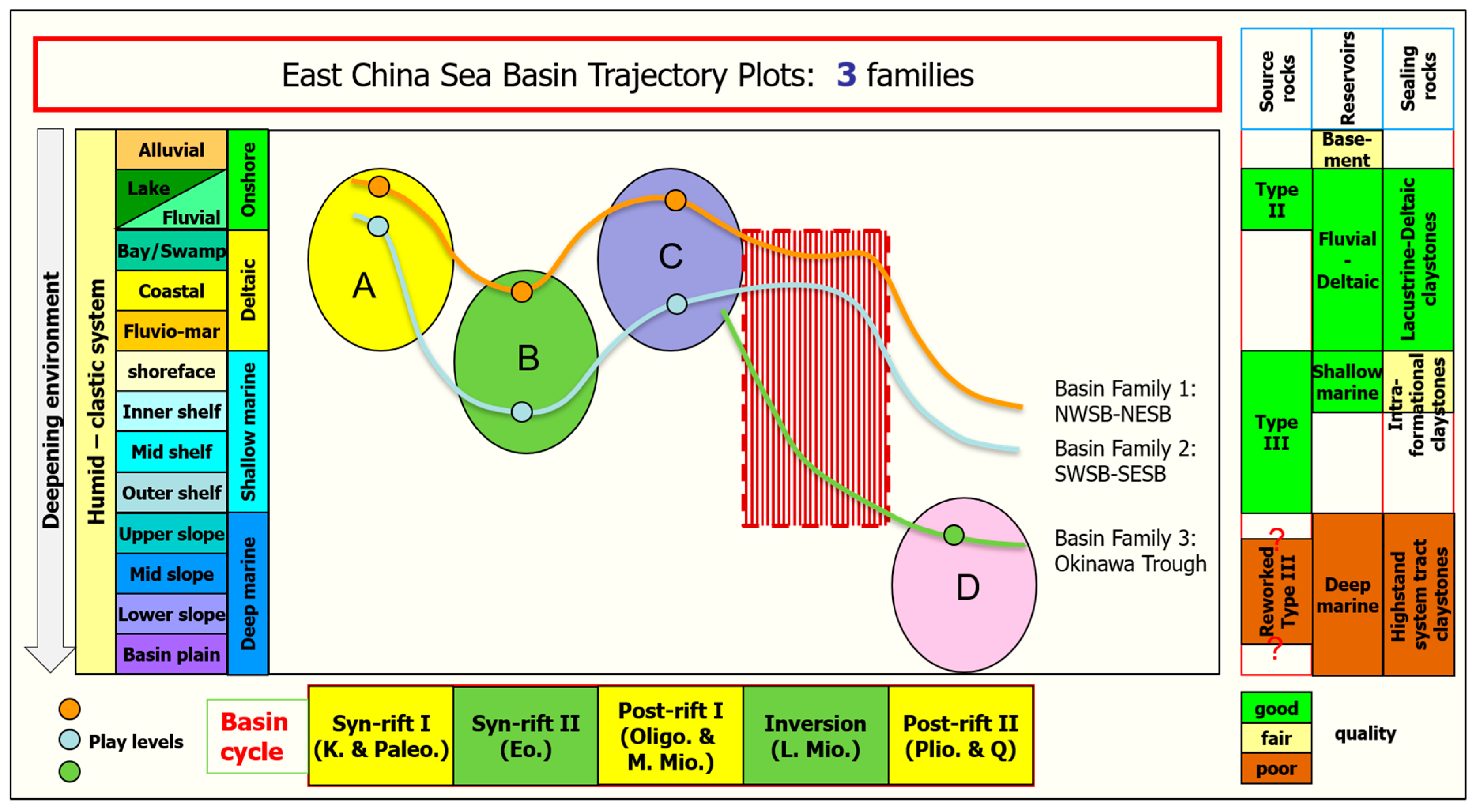
4.5. Trends in Basin Evolution and Their Prospectivity

The distribution of the petroleum systems is dependent on the sedimentary basin history. It was demonstrated that knowledge of the syn- and post-rift basin evolution and the succession of depositional environments makes it possible to identify potential petroleum systems and their constituent plays (see also Doust et al. [18]). To support this approach, a number of characteristic trends in the East China Sea Basin were distinguished, which have distinct “trajectories” through a matrix of changing depositional environments and basin development phases (Figure 16). This is the first time that this approach was applied in the East China Sea Basin.
• Northwest Shelf Basin group (NWSB)
These basins are located at the northern part of the West Shelf Basin and include the Changjiang and Qiantang sub-basins. These sub-basins are the most proximal in this part of the East China Sea and lie between basement high zones or paleo-highs. As a result, they were the most protected from marine influence during both syn-rift and early post-rift cycles. Accordingly, the dominant petroleum system type is PST A, early syn-rift lacustrine–deltaic.
• Southwest Shelf Basin group (SWSB)
These basins are located at the southern part of the West Shelf Basin, and comprise the Lishui, Jiaojiang, Fuzhou, and Minjiang sub-basins. They are also proximal and are relatively protected from open marine environments by a NE–SW trending paleo-high. Their basin history is similar to that of the Northwest group, with the exception that a southeastward tilt in the late syn-rift resulted in marine incursions from the end of the early syn-rift into the late syn-rift stages. Type III shallow marine claystone source rocks accumulated in the late syn-rift, but the dominant petroleum system type is PST A, early syn-rift lacustrine–deltaic, with reservoirs located in the early post-rift.
• Northeast and Southeast Shelf Basin groups (NESB, SESB)
These basins include the Xihu and Fujiang sub-basins, the northern part of the East Shelf Basin, and the Diaobei sub-basin to the south. All three petroleum system types, i.e., PST A, PST B, and PST C, may be developed in this group. Among them, the most dominant one is PST B, late syn-rift marine.
As with the western group of basins, the early syn-rift and late syn-rift basin evolution phases in the southern group were subject to marine incursions, but these did not reach the northern area. This is reflected by the source material for PST B. Although fluvial–deltaic lithofacies are present throughout, claystones with type II organic material are better developed in the Diaobei Sub-basin [1,57].
• Okinawa Trough
The Okinawa Trough Basin is distinct from the other basins, showing the typical characteristics of young rifting processes within deeper marine depositional environments. The presence of a syn-rift turbiditic petroleum system type (PST D) is highly speculative.

5. Summary and Conclusions

The sub-basins of the East China Sea Basin share a common tectonic evolution, from Paleogene syn-rift to Neogene post-rift. They are filled with sediments deposited in environments that evolved from terrestrial lacustrine to transitional into more marine, and they were subject to a series of compressional/inversion events. The only exception is the Okinawa Trough, which is a very young, back-arc sub-basin in which rifting started during the Middle Miocene.
Petroleum systems identified and potentially present in the various sub-basins of the East China Sea Basin can be grouped into four types (PSTs), which can be directly related to the main stages of basin development. These PSTs are the following:
  • Early syn-rift lacustrine–deltaic PST: Oil/gas-prone, with charge from type II source rocks complemented with limited charge from type III shallow marine source rocks and type I lacustrine source rocks.
  • Late syn-rift marine PST: Gas/oil-prone, derived from type III shallow marine source rocks.
  • Early post-rift fluvial–deltaic PST: Gas/oil-prone, with the main source rock in marginal deltaic to shallow marine sediments. The charge and the reservoir are commonly not in the same basin evolution stage.
  • Syn-rift turbiditic PST: Gas-prone, with the re-worked type III coal-bearing claystones brought in by turbidites as the potential source rocks.
Differences in paleogeographic position influence the distribution and development of the petroleum systems in the sub-basins. In particular, the balance between non-marine, more proximal environments and the presence of marine incusions in both syn- and post-rift in the southern area impacts the source facies.
  • In the northwest (Changjiang and Qiantang sub-basins), only the early syn-rift lacustrine–deltaic PST is found.
  • Basins in the southwest (Lishui, Jiaojiang, Fuzhou, and Minjiang sub-basins) also contain the early syn-rift lacustrine–deltaic PST only, but the depositional environments include marine intervals.
  • The position of the basins in the northeast (Xihu and Fujiang sub-basins), with an evolution from non-marine to marine conditions, allows all three PSTs to be developed. The most dominant petroleum system type, however, is the late syn-rift marine PST. Further to the south (Diaobei Sub-basin), the late syn-rift marine PST is dominant, but the potential for the early syn-rift lacustrine–deltaic and early post-rift fluvial-deltaic PSTs to be developed exists.
  • In the Okinawa Trough, no proven petroleum systems or reservoir formations are yet identified, and the proposed syn-rift turbiditic PST is highly speculative.

Author Contributions

B.W. performed the research and drafted the article; H.D. supervised the research and reviewed it critically; J.L. completed the review and English check.

Funding

The publication of the paper was funded by the Key National Natural Science Foundation of China (Grant No.91328201), the National Natural Science Foundation of China (Grant No. 40972081), and the Fundamental Research Funds for the Central Universities (Grant No. 2-9-2013-095).

Acknowledgments

The authors thank Suzanne Beglinger for original data preparation and acknowledge informal discussions with former Shell colleagues. The authors also thank the great contribution and valuable time of anonymous reviewers.

Conflicts of Interest

There are no known conflicts of interest.

References

  1. Zhou, Z.; Zhao, J.; Yin, P. Characteristics and tectonic evolution of the East China Sea. In Chinese Sedimentary Basins; Zhu, X., Ed.; Sedimentary Basins of the World; Elsevier Science: Amsterdam, The Netherlands, 1989; Volume 1, pp. 165–179. [Google Scholar]
  2. Ye, J.; Qing, H.; Bend, S.L.; Gu, H. Petroleum systems in the offshore Xihu Basin on the continental shelf of the East China Sea. AAPG Bull. 2007, 91, 1167–1188. [Google Scholar] [CrossRef]
  3. Chen, J.; Ge, H.; Chen, X.; Deng, C.; Liang, D. Classification and origin of natural gases from Lishui Sag, the East China Sea Basin. Sci. China Ser. D Earth Sci. 2008, 51, 122–130. [Google Scholar] [CrossRef]
  4. Silverman, M.R.; Wang, Q.; Byrd, B.L.; Zhao, J.K.; Zhang, H.Y.; Chen, M.; Weimer, P. 3-D evaluation of the Ping Hu field, East China Sea. In Applications of 3-D Seismic Data to Exploration and Production; Weimer, P., Davis, T.L., Eds.; AAPG Studies in Geology; American Association of Petroleum Geologists: Tulsa, OK, USA, 1996; Volume 42, pp. 91–101. [Google Scholar]
  5. Chen, Z. Analysis of hydrocarbon potential and selection of exploration prospect of Lishui and Jiaojiang sags. China Offshore Oil Gas (Geol.) 1997, 11, 451–458. [Google Scholar]
  6. Chen, Z.; Wu, P.; Wu, Z. Petroleum geology and exploration potential of Lishui Sag. China Offshore Oil Gas (Geol.) 2000, 14, 384–391. [Google Scholar]
  7. Chen, J.; Li, G.; Chen, G. Petroleum prospects of Mesozoic and Paleocene in the Western Depression of the East China Sea Shelf Basin. Mar. Geol. Lett. 2003, 19, 17–19. [Google Scholar]
  8. Yu, H.; Ji, W. Geology of the Taiwan Basin. Pet. Geol. Taiwan 1992, 27, 73–88. [Google Scholar]
  9. Liu, J.; Wu, J.; Fang, Y.; Wang, S. Pre-Cenozoic groups in the shelf basins of the East China Sea. Acta Oceanol. Sin. 2007, 29, 66–75. [Google Scholar]
  10. Tian, H. Research on the oil-bearing series of Xihu Depression. J. China Univ. Pet. 2000, 24, 38–43. [Google Scholar]
  11. Wang, L.; Wang, L. Petroleum geology in Sudi Structural Belt, Xihu Trough. China Offshore Oil Gas (Geol.) 2000, 14, 392–397. [Google Scholar]
  12. Ye, J.; Gu, H. Characteristics and exploration evaluation of the petroleum systems in Xihu Depression of East China Sea. Nat. Gas Ind. 2004, 24, 8–11. [Google Scholar]
  13. Jiang, Z.; Li, Y.; Du, H.; Zhang, Y. The Cenozoic structural evolution and its influences on gas accumulation in the Lishui Sag, East China Sea Shelf Basin. J. Nat. Gas Sci. Eng. 2015, 22, 107–118. [Google Scholar] [CrossRef]
  14. He, D.; Mao, X.; Yang, J.; Wu, J.; Pan, M. Development of petroleum pool-forming dynamics simulation and evaluation system. Pet. Geol. Exp. 2007, 29, 527–530. [Google Scholar]
  15. Huang, Z.; Hao, S.; Jiang, L. Assemblages and patterns of forming oil and gas reservoirs in Lishui Seg of East China Sea Basin. Nat. Gas Ind. 2001, 21, 17–21. [Google Scholar]
  16. Doust, H. Placing petroleum systems and plays in their basin history context: A means to assist in the identification of new opportunities. First Break 2003, 21, 73–83. [Google Scholar]
  17. Kingston, D.R.; Dishroon, C.P.; Williams, P.A. Global basin classification system. AAPG Bull. 1983, 67, 2175–2193. [Google Scholar] [CrossRef]
  18. Doust, H.; Sumner, H.S. Petroleum systems in rift basins—A collective approach in Southeast Asian basins. Pet. Geosci. 2007, 13, 127–144. [Google Scholar] [CrossRef]
  19. Ziegler, P.A.; Cloetingh, S. Dynamic processes controlling evolution of rifted basins. Earth Sci. Rev. 2004, 64, 1–50. [Google Scholar] [CrossRef]
  20. Cloetingh, S.; Ziegler, P.A. Tectonic models for the evolution of sedimentary basins. In Treaties on Geophysics; Watts, A.B., Schubert, G., Eds.; Crustal and Lithosphere Dynamics; Elsevier, B.V.: Amsterdam, The Netherlands, 2007; Volume 6, pp. 485–611. [Google Scholar] [CrossRef]
  21. Corver, M.P.; Doust, H.; Van Wees, J.D.; Bada, G.; Cloetingh, S. Classification of rifted sedimentary basins of the Pannonian Basin System according to the structural genesis, evolutionary history and hydrocarbon maturation zones. Mar. Pet. Geol. 2009, 26, 1452–1464. [Google Scholar] [CrossRef]
  22. Beglinger, S.E.; Corver, M.P.; Doust, H.; Cloetingh, S.; Thurmond, A.K. A new approach of relating petroleum system and play development to basin evolution: An application to the conjugate margin Gabon coastal and Almada-Camamu basins. AAPG Bull. 2012, 96, 953–982. [Google Scholar] [CrossRef]
  23. Magoon, L.B.; Dow, W.G. The petroleum system. In The Petroleum System—From Source to Trap; Magoon, L.B., Dow, W.G., Eds.; Memoirs 60; American Association of Petroleum Geologists: Tulsa, OK, USA, 1994; pp. 3–24. [Google Scholar]
  24. Letouzey, J.; Kimura, M. Okinawa Trough genesis: Structure and evolution of a backarc basin developed in a continent. Mar. Pet. Geol. 1985, 2, 111–130. [Google Scholar] [CrossRef]
  25. Lee, C.; Shor, G.G., Jr.; Bibee, L.D.; Lu, R.S.; Hilde, T. Okinawa Trough: Origin of a back-arc basin. Mar. Geol. 1980, 35, 219–241. [Google Scholar] [CrossRef]
  26. Kimura, M. Back-arc rifting in the Okinawa Trough. Mar. Pet. Geol. 1985, 2, 222–240. [Google Scholar] [CrossRef]
  27. Sibuet, J.C.; Hsu, S.K.; Shyu, C.T.; Liu, C.S. Structural and kinematic evolutions of the Okinawa Trough back-arc basin. In Backarc Basins: Tectonics and Magmatism; Taylor, B., Ed.; Plenum Press: New York, NY, USA, 1995; pp. 343–379. [Google Scholar] [CrossRef]
  28. Sibuet, J.C.; Hsu, S.K. Geodynamics of Taiwan arc–arc collision. Tectonophysics 1997, 274, 221–251. [Google Scholar] [CrossRef]
  29. Park, J.-O.; Tokuyama, H.; Shinohara, M.; Suyehiro, K.; Taira, A. Seismic record of tectonic evolution and backarc rifting in the southern Ryukyu island arc system. Tectonophysics 1998, 294, 21–42. [Google Scholar] [CrossRef]
  30. Sibuet, J.C.; Deffontaines, B.; Hsu, S.K.; Thareau, N.; Formal, J.P.L.; Liu, C. Okinawa trough backarc basin: Early tectonic and magmatic evolution. J. Geophys. Resour. 1998, 103, 30245–30267. [Google Scholar] [CrossRef] [Green Version]
  31. Kong, F.; Lawver, L.A.; Lee, T.-Y. Evolution of the southern Taiwan–Sinzi Folded Zone and opening of the southern Okinawa trough. J. Asian Earth Sci. 2000, 18, 325–341. [Google Scholar] [CrossRef]
  32. Hall, R. Cenozoic geological and plate tectonic evolution of SE Asia and the SW Pacific: Computer-based reconstructions, model and animations. J. Asian Earth Sci. 2002, 20, 353–431. [Google Scholar] [CrossRef]
  33. Jolivet, L.; Huchon, P.; Rangin, C. Tectonic setting of Western Pacific marginal basins. Tectonophysics 1989, 160, 23–47. [Google Scholar] [CrossRef]
  34. Letouzey, J.; Kimura, M. The Okinawa Trough: Genesis of a back-arc basin developing along a continental margin. Tectonophysics 1986, 125, 209–230. [Google Scholar] [CrossRef]
  35. Sibuet, J.-C.; Letouzey, J.; Barbier, F.; Charvet, J.; Foucher, J.-P.; Hilde, T.W.C.; Kimura, M.; Chiao, L.-Y.; Marsset, B.; Muller, C.; et al. Back Arc Extension in the Okinawa Trough. J. Geophys. Res. 1987, 92, 14041–14063. [Google Scholar] [CrossRef] [Green Version]
  36. Yang, Z. The type and basining period of Cenozoic sedimentary basin in East China Sea. Mar. Geol. Quat. Geol. 1992, 2, 3–13. [Google Scholar]
  37. Wang, G.M.; Coward, M.P.; Yuan, W.; Liu, S.; Wang, W. Fold growth during basin inversion-Example from the East China Sea basin. In Basin Inversion; Buchanan, J.G., Buchanan, P.G., Eds.; Special Publication 88; The Geological Society: London, UK, 1995; pp. 493–522. [Google Scholar] [CrossRef]
  38. Li, C.; Zhou, Z.; Ge, H.; Mao, Y. Rifting process of the Xihu Depression, East China Sea Basin. Tectoniphysics 2008, 472, 135–147. [Google Scholar] [CrossRef]
  39. Uyeda, S.; Kanamori, H. Back-arc opening and the mode of subduction. J. Geophys. Res. 1979, 84, 1049–1061. [Google Scholar] [CrossRef] [Green Version]
  40. Van Wijk, J.W. Passive Margin Formation: Tectonic Modeling of Pre- and Syn-Rift Lithospheric Controls. Ph.D. Thesis, Vrije Universiteit Amsterdam, Amsterdam, The Netherlands, 2002. [Google Scholar]
  41. Lambiase, J.J.; Morley, C.K. Hydrocarbons in rift basins: The role of stratigraphy. Philos. Trans. R. Soc. Lond. Ser. A Math. Phys. Eng. Sci. 1999, 357, 877–900. [Google Scholar] [CrossRef]
  42. Lin, Z.; Zhou, P. Evolution of Cenozoic sedimentary facies of Xihu Depression of the shelf basin of the East China Sea. Mar. Geol. Quat. Geol. 1994, 2, 63–70. (In Chinese) [Google Scholar]
  43. Harland, W.B.; Armstrong, R.L.; Cox, A.V.; Craig, L.E.; Smith, A.G.; Smith, D.G. A Geological Time Scale 1989; Cambridge University Press: Cambridge, UK, 1990. [Google Scholar] [CrossRef]
  44. Zhao, Y. Pool-forming geology of Xihu depression in the East China Sea. Mar. Geol. Lett. 2003, 19, 20–24. [Google Scholar]
  45. Miller, M.S.; Kennett, B.L.N.; Toy, V.G. Spatial and temporal evolution of the subducting Pacific Plate structure along the western Pacific margin. J. Geophys. Res. 2006, 111, B02401. [Google Scholar] [CrossRef]
  46. Lallemand, S.; Theunissen, T.; Schnürle, P.; Lee, C.-S.; Liu, C.-S.; Font, Y. Indentation of the Philippine Sea plate by the Eurasia plate in Taiwan: Details from recent marine seismological experiments. Tectonophysics 2013, 594, 60–79. [Google Scholar] [CrossRef] [Green Version]
  47. Nash, D.F. The geological development of the north Okinawa Trough area from Neogene times to Recent. J. Jpn. Assoc. Pet. Technol. 1979, 44, 109–119. [Google Scholar] [CrossRef]
  48. Peters, K.E.; Cassa, M.R. Applied source rock geochemistry. In the Petroleum System—From Source to Trap; Magoon, L.B., Dow, W.G., Eds.; Memoir 60; American Association of Petroleum Geologists: Tulsa, OK, USA, 1994; pp. 93–120. [Google Scholar]
  49. Lee, G.H.; Kim, B.; Shin, K.S.; Sunwoo, D. Geologic evolution and aspects of the petroleum geology of the northern East China Sea shelf basin. AAPG Bull. 2006, 90, 237–260. [Google Scholar] [CrossRef]
  50. Xu, X.H.; Chen, B.; Wei, H.K. Analysis of oil and gas accumulating condition in the north area of Xihu Basin. Offshore Oil 1998, 3, 40–43. [Google Scholar]
  51. Wang, Y. Relation between extensional movement and formation of oil-gas pools in Lishui-JiaoJiang Sag. Oil Gas Geol. 1999, 20, 316–320. [Google Scholar]
  52. Wang, Y.; Jiang, L.; Yang, W. Kinematical analysis on faults in the Lishui-Jiaojiang Sag. Sci. Geol. Sin. 2000, 35, 441–448. [Google Scholar]
  53. Jia, C.; Xia, B.; Wang, H.; Zhang, S. Characteristic of teoconic evolution and petroleum geology in Lishui Sag, East China Sea Basin. Nat. Gas Geosci. 2006, 17, 397–401. [Google Scholar]
  54. Takano, O. Changes in depositional systems and sequences in response to basin evolution in a rifted and inverted basin: An example from the Neogene Niigata-Shin’etsu basin, northern Fossa Magna, central Japan. Sediment. Geol. 2002, 152, 79–97. [Google Scholar] [CrossRef]
  55. Hsu, S.-K.; Sibuet, J.-C.; Shyu, C.-T. Magnetic inversion in the East China Sea and Okinawa Trough: Tectonic implications. Tectonophysics 2001, 333, 111–122. [Google Scholar] [CrossRef]
  56. Haq, B.U.; Hardenbol, J.; Vail, P.R. Chronology of Fluctuating Sea Levels since the Triassic. Science 1987, 235, 1156–1167. [Google Scholar] [CrossRef]
  57. Bai, Y. Evolution Features and Tectonic Migration Trends of the Mesozoic and Cenozoic Basins in Eastern China. Master’s Thesis, China University of Geosciences, Beijing, China, 2014. [Google Scholar]
Figure 1. Regional location and sub-units of the East China Sea Basin. Pink represents the paleo-uplift, dark green indicates the sub-basin, yellow represents the local low-uplift, brown represents land area, and light blue represents sea.
Energies 12 04088 g001
Figure 2. Schematic tectonic cross-section across the East China Sea basins. The East China Sea Shelf Basin and the western part of Okinawa Trough are modified from Reference [1], while the eastern part of the Okinawa Trough and Ryukyu Trench is a schematic. The thicknesses indicated here are approximate.
Energies 12 04088 g002
Figure 3. Tectono-stratigraphy of the sub-basins of the East China Sea Basin, showing regional tectonic events and (sub-)basin cycles. For each basin, the columns from left to right show the stress regime and the cycle/stage divisions.
Energies 12 04088 g003
Figure 4. Two types of subduction boundaries related to subduction steepness. Type 1 (“flat-slab subduction”) = compression/thrusting in the back-arc region; type 2 (“steep-slab subduction”) = tension in the back-arc region (modified from Uyeda et al. [39]). During type 1, inversions can be expected in the back-arc basin.
Energies 12 04088 g004
Figure 5. Chrono-stratigraphy of the West Shelf Basin (i.e., Lishui Sub-basin), East Shelf Basin (i.e., Xihu Sub-basin), and the Okinawa Trough of the East China Sea Basin, showing lithofacies, (sub-)basin cycles, and identified petroleum system types (PSTs) and their play levels. A = PST A; B = PST B; C = PST C; D = PST D (black dashed lines show the extent of each PST). In the stratigraphic column, green represents claystone, yellow indicates sandstone, blue stands for carbonate, black represents coal, and red indicates volcanics. Time scale and lithology are based on data and analyses in References [1,24,27,34,35,36,42,43].
Energies 12 04088 g005
Figure 6. Structural units of the Xihu Sub-basin (West Shelf Basin). Location of major hydrocarbon fields and hydrocarbon-bearing structures and their PSTs are also indicated in the map. Note that all belong to the late syn-rift marine PST. 1 = Chunxiao field; 2 = Tianwaitian field; 3 = Duanqiao field; 4 = Canxue field; 5 = Pinghu field; 6 = Baoyunting field; 7 = Wuyunting field; 8 = Wubei field; 9 = Laiheting field; 10 = Kongqueting field; 11 = Gushan 1 discovery; 12 = Qiuyue 1 discovery; 13 = Yuquan discovery; 14 = Huagang 1 discovery; 15 = Longjing 1 discovery; 16 = Longjing 2 discovery; 17 = Longjing 4 discovery.
Energies 12 04088 g006
Figure 7. Xihu Sub-basin tectonic cross-section (seismic line location is indicated in Figure 6). The seismic horizons can be referred to Figure 3. Question marks indicate uncertainties in the interpretation.
Energies 12 04088 g007
Figure 8. Event chart of the Pinghu–Huagang Petroleum System (!) in the Xihu Sub-basin.
Energies 12 04088 g008
Figure 9. Event chart of the Huagang–Huagang Petroleum System (?) in the Xihu Sub-basin.
Energies 12 04088 g009
Figure 10. Proven and speculative plays of the Xihu Sub-basin shown on a composite cross-section (refer to Figure 6 for the section location). Note that all belong to the Pinghu–Huagang Petroleum System (!). i-1 = Pinghu structural (proven); i-2 = Pinghu structural–stratigraphic (proven); i-3 = Huagang structural (proven); i-4 = Huagang stratigraphic (proven); i-5 = Huagang structural–stratigraphic (proven); ii-1 = Basement structural–stratigraphic (speculative); ii-2 = Miocene structural (speculative); ii-3 = Miocene stratigraphic (speculative). Those indicated in the graph for each play are only examples. Please refer to Table 1 for real examples. S1 = early syn-rift; S2 = late syn-rift; IN = inversion; P1 = early post-rift; P2 = late post-rift.
Energies 12 04088 g010
Figure 11. Location map of major hydrocarbon fields, non-commercial discoveries, and sub-units of the Lishui Sub-basin. Blue areas indicate the regions of the mature source rocks (modified from Chen et al. [3]).
Energies 12 04088 g011
Figure 12. Schematic geological cross-section of the Lishui Sub-basin, and its proven and speculative plays. Note that all belong to the Yueguifeng–Lingfeng Petroleum System (!). Line location is indicated in Figure 11. All the red lines are normal faults; S = syn-rift; P1 = early post-rift; P2 = late post-rift; i-1 = Lingfeng structural (proven); i-2 = Mingyuefeng structural (proven); i-3 = Basement structural–stratigraphic (proven); ii-1 = Oujiang structural (speculative).
Energies 12 04088 g012
Figure 13. Event chart of the Yueguifeng–Lingfeng Petroleum System (!) in the Lishui Sub-basin.
Energies 12 04088 g013
Figure 14. Schematic tectonic cross-section of the northern part of the Okinawa Trough and its speculative plays, all of which relate to a speculative Neogene/Quaternary–Neogene/Quaternary Petroleum System (?). The seismic line and the To-Ka-1 well location are indicated in Figure 1. All the red lines are normal faults; i-1 = Neogene structural; i-2 = Neogene stratigraphic; i-3 = Quaternary structural; i-4 = Quaternary stratigraphic. The location of well To-Ka-1 in the Okinawa Trough and the seismic profile across the well are shown in Figure 1.
Energies 12 04088 g014
Figure 15. Event chart of the speculative Neogene/Quaternary–Neogene/Quaternary Petroleum System (?). Question marks indicate uncertainties. The sea level curve is from Haq et al. [56].
Energies 12 04088 g015
Figure 16. Petroleum system types in the East China Sea Basin showing the depositional environment evolution in relation to tectonic basin stages. The tectono-stratigraphic situation of PSTs is indicated by colored ovals: A (yellow) = PST A; B (green) = PST B; C (mauve) = PST C and D; (pink) = PST D. NWSB = Northwest Shelf Basin; NESB = Northeast Shelf Basin; SWSB = Southwest Shelf Basin; SESB = Southeast Shelf Basin. The red dashed area shows the inversion cycle, which is largely an unconformity and a depositional hiatus.
Energies 12 04088 g016
Table 1. Summary of hydrocarbon fields and discoveries of the Xihu Sub-basin.
Field/Discovery NameReservoirSource Rock
Unit NameAgeLithologyUnit NameAgeLithology
Chunxiao fieldHuagang FormationOligoceneSandstonePinghu FormationEoceneClaystone
Pinghu FormationEoceneSandstonePinghu FormationEoceneClaystone
Tianwaitian fieldHuagang FormationOligoceneSandstone–claystonePinghu FormationEoceneClaystone
Duanqiao fieldHuagang FormationOligoceneSandstone–siltstonePinghu FormationEoceneClaystone
Pinghu FormationEoceneSandstone–siltstonePinghu FormationEoceneClaystone
Canxue fieldHuagang FormationMiddle–Late OligoceneSandstonePinghu FormationEoceneClaystone
Pinghu fieldHuagang FormationOligoceneSandstone–siltstonePinghu FormationEoceneClaystone
Pinghu FormationEoceneSandstone–siltstonePinghu FormationEoceneClaystone
Baoyunting fieldPinghu FormationEoceneSandstonePinghu FormationEoceneClaystone
Wuyunting fieldHuagang FormationOligoceneSandstonePinghu FormationEoceneClaystone
Wubei fieldPinghu FormationEoceneSandstonePinghu FormationEoceneClaystone
Laiheting fieldPinghu FormationEoceneSandstonePinghu FormationEoceneClaystone
Kongqueting fieldPinghu FormationEoceneSandstonePinghu FormationEoceneClaystone
Gushan 1 discoveryHuagang FormationOligoceneSandstonePinghu FormationEoceneClaystone
Qiuyue 1 discoveryHuagang FormationOligoceneSandstonePinghu FormationEoceneClaystone
Yuquan discoveryHuagang FormationOligoceneSandstonePinghu FormationEoceneClaystone
Huagang 1 discoveryHuagang FormationOligoceneSandstonePinghu FormationEoceneClaystone
Longjing 1 discoveryHuagang FormationOligocene–MioceneSandstone–coalPinghu FormationEoceneClaystone
Longjing 2 discoveryHuagang FormationOligoceneSandstonePinghu FormationEoceneClaystone
Longjing 4 discoveryHuagang FormationOligoceneSandstonePinghu FormationEoceneClaystone
Field/Discovery NameSealPlayHydrocarbon Type
Unit NameAgeLithologyPlay NameTrap Type
Chunxiao fieldHuagang FormationOligoceneClaystoneHuagang structuralStructural—inverted anticline and reverse fault related footwall closuresGas, condensate, oil
Pinghu FormationEoceneClaystonePinghu structuralStructural—inverted anticlineOil, gas, condensate
Tianwaitian fieldHuagang FormationOligoceneClaystoneHuagang structuralStructural—inverted anticline and reverse fault related footwall closuresGas, condensate
Duanqiao fieldHuagang FormationOligoceneClaystoneHuagang structuralStructural—inverted anticline and reverse fault related footwall closuresGas, condensate
Pinghu FormationEoceneClaystonePinghu structuralStructural—inverted anticlineGas, condensate
Canxue fieldHuagang FormationOligoceneClaystoneHuagang structuralStructural—inverted anticline and faultGas, condensate
Pinghu fieldHuagang FormationOligoceneClaystoneHuagang structural–stratigraphicStructural–stratigraphic—fault-bounded closures with facies changeOil, gas
Pinghu FormationEoceneClaystonePinghu structuralStructural—fault bounded compressional hanging wall anticlineGas, condensate
Baoyunting fieldPinghu FormationEoceneClaystonePinghu structuralStructural—fault bounded compressional hanging wall anticlineGas, condensate, oil
Wuyunting fieldHuagang FormationOligoceneClaystoneHuagang structural–stratigraphicStructural–stratigraphic—fault-bounded closures with facies changeOil, gas
Wubei fieldPinghu FormationEoceneClaystonePinghu structuralStructural—fault bounded compressional hanging wall anticlineGas, condensate
Laiheting fieldPinghu FormationEoceneClaystonePinghu structuralStructural—fault bounded compressional hanging wall anticlineOil, gas
Kongqueting fieldPinghu FormationEoceneClaystonePinghu structuralStructural—fault bounded compressional hanging wall anticlineOil, gas
Gushan 1 discoveryHuagang FormationOligoceneClaystoneHuagang structuralStructural—fault Oil, gas
Qiuyue 1 discoveryHuagang FormationOligoceneClaystoneHuagang structuralStructural—fault Gas, condensate
Yuquan discoveryHuagang FormationOligoceneClaystoneHuagang structuralStructural—inverted anticline and reverse fault related footwall closuresGas
Huagang 1 discoveryHuagang FormationOligoceneClaystoneHuagang structuralStructural—inverted anticline and reverse fault related footwall closuresGas
Longjing 1 discoveryHuagang FormationOligoceneClaystoneHuagang structuralStructural—inverted anticline and reverse fault related footwall closuresGas, condensate
Longjing 2 discoveryHuagang FormationOligoceneClaystoneHuagang structuralStructural—inverted anticline and reverse fault related footwall closuresGas
Longjing 4 discoveryHuagang FormationOligoceneClaystoneHuagang structuralStructural—inverted anticline and reverse fault related footwall closuresOil, gas
Table 2. Abundance of organic matter in the Xihu Sub-basin (from Ye et al. [2]).
Stratigraphic UnitLithologyTOC *EOM HC
Max. §Min. Avg. 1n2ppmn2ppmn2
MioceneLiulang FormationMudstone0.970.140.37861398314840
Coal68.0028.5448.272
Yuquang FormationMudstone2.590.150.85593305817337
Coal67.0019.0047.24619,281644916
Longjing FormationMudstone1.100.270.4713126512713878
Coal79.4227.0053.212
OligoceneUpper Huagang FormationMudstone1.910.160.37210194201106115
Coal79.6127.0062.31416,875454724
Lower Huagang FormationMudstone2.280.170.71213231204125119
Coal92.1827.2859.7322013474014
EocenePinghu FormationMudstone4.230.311.31182530176254134
Coal80.2519.4061.84619,27615856712
* TOC = total organic carbon. EOM = extractable organic matter. HC = hydrocarbons. § Max. = maximum TOC values. Min. = minimum TOC values. 1 Avg. = average TOC values. 2 n = number of samples.
Table 3. Summary of hydrocarbon fields and discoveries of the Lishui Sub-basin.
Field/Discovery NameReservoirSource Rock
Unit NameAgeLithologyUnit NameAgeLithology
LS 36-1-1 fieldMingyufeng FormationLate PaleoceneSandstone
Lingfeng FormationLate PaleoceneSandstoneLingfeng FormationLate PaleoceneClaystone
LF-1 discoveryBasementPrecambrianGneissYueguifeng FormationEarly PaleoceneClaystone
WZ 13-1-1 discoveryLingfeng FormationLate PaleoceneSandstoneLingfeng FormationLate PaleoceneClaystone
SMT-1 discoveryLingfeng FormationLate PaleoceneSandstoneYueguifeng FormationEarly PaleoceneClaystone
Lingfeng FormationEarly PaleoceneSandstoneYueguifeng FormationEarly PaleoceneClaystone
Field/Discovery NameSealPlayHydrocarbon Type
Unit NameAgeLithologyPlay NameTrap
LS 36-1-1 field Mingyuefeng structural Structural—inverted anticlinesGas
Lingfeng FormationLate PaleoceneClaystoneLingfeng structuralStructural—inverted anticlinesGas, condensate
LF-1 discoveryLingfeng FormationLate PaleoceneClaystoneBasement structural–stratigraphicStructural–stratigraphic—porous basement in topographic reliefOil, gas
WZ 13-1-1 discoveryLingfeng FormationLate PaleoceneClaystoneLingfeng structuralStructural—footwall closuresGas
SMT-1 discoveryLingfeng FormationLate PaleoceneClaystoneLingfeng structuralStructural—footwall closuresGas
Lingfeng FormationLate PaleoceneClaystoneLingfeng structuralStructural—footwall closuresGas

