1. Introduction
In recent decades, the public nature of public spaces has been diminishing globally, suggesting that public space is losing its potential to provide opportunities for social interaction. Some superficial explanations suggest that the possible reasons for this stem from the suppression of the creative sphere in the context of homogenization constructed by globalization. Individuality and uniqueness have been destroyed and urban spaces tend to be similar. As described in the Beijing Charter, “a thousand cities all look alike” in the eyes of people today [
1]. This is the dilemma facing today’s cities, as the public memory carried by distinctive buildings and neighborhoods in urban public spaces is being destroyed with the rapid development. This in turn further promotes the loss of the meaning of public space, and gradually makes the public space in modern cities a meaningless transitional space where people find it difficult to develop a sense of belonging.
Many scholars have studied the publicness of urban public space in terms of its ownership, cognition, management, and public activities. A typical one is the Project of Public Space (2010). Based on a study of thousands of public spaces, this project concluded that a highly public space should have the characteristics of Social activities, Comfort and image, Accessibility, and Sociability to facilitate the interaction between the residents and the space. This view is not alone, as Arentze, Afonso, Ye et al. argue that the daily activities of individuals/families are driven by a set of universal needs, and thus travel time, comfort, and sociability are important factors that drive public engagement in public spaces [
2,
3,
4]. At the same time this process of social–spatial interaction as a dynamic flow plays a considerable degree of permeability to its neighboring spaces, and thus on this level good public spaces will prove influential to neighborhoods beyond the limits of its own physical space. This idea is also similar to the one that was proposed by Jane Jacobs and William H. White in the 1960s in response to spatial deactivation—namely, the use of place-making, i.e., the use of a community’s assets, values, and resources to create a place that promotes people’s health, well-being, and happiness in order to enhance their sense of identity and the meaning of place [
5,
6,
7,
8,
9,
10].
The most prominent number of these related studies for spatial accessibility and morphology, Ye and Le Texier conclude that accessibility plays a crucial activity in public engagement, and the morphology of urban spaces will largely influence people’s choices [
4,
11]. Although many studies have investigated public spaces in detail, these studies have not explored the association between public participation (publicness) and accessibility, choice and urban form, using a quantitative approach for specific sites from a design perspective. In addition, there are fewer studies on the quantitative analysis of spatial morphology, and the challenge of constructing correlations with actual social phenomena leads to difficulties in applying the results of the analysis to design.
At the same time, in the context of China’s urban public space, the density, intensity, and height of the built environment have increased dramatically in the urbanization process since the implementation of the reform and opening-up policy 40 years ago [
12]. The massive development and construction of urban centers has compensated for the lack of commercial space in the original areas. However, excessive commercialization has encroached on public space, while people are attracted to commercial services and neglect public space during their walks [
13,
14]. Commercial spaces pre-screen residents due to their ownership and the consumption or services they provide. As a result, there is a discontinuity and disintegration of spatial experience for some residents. This reduces the interaction between the individual and the environment, thus re-diminishing the resident’s identification with place [
15,
16].
As Rowan Moore argues in his book The Slow Born City, cities should change gradually, with a combination of private investment, public interest, and legislative action, rather than destructive change. Therefore, this study will interpret the evolution of urban spatial forms in the process of urban development in the context of “micro-renewal” with a Space Syntax in order to obtain the basic characteristics of urban forms and spatial accessibility and choices. Secondly, we make long-term observations of the site and map the location of public activities. By calculating the correlation between these two types of spatial elements, the results are finally projected onto the different morphological types of urban public space to determine the role of urban morphology in promoting public participation. Based on this, this study attempts a combined qualitative–quantitative approach to public space, exploring the significance of spatial design in leading to positive human well-being, and the demonstration and testing of the feasibility of design potential. The lack of empirical analysis of spatial planning is remedied.
2. Literature Review
This chapter focuses on the definition of urban public space and the social significance it carries. On the basis of this chapter, the research objectives of this paper are combined with the research perspectives of choice, accessibility, and typology for the study of public space. Finally, it summarizes the Space Syntax and related research methods.
2.1. Publicness of Urban Space
Place and space have long been the focus of discussion in academic circles. In the context of urban design, the two can be used alternatively. Place is considered to be a space bearing social relations and identity [
6,
7,
8,
9]. Therefore, public engagement is particularly important in urban design. Lefebvre believes that active space (place with functions and meanings) is the result of people using space to implement daily necessities [
17]. Urban design in turn endows place with meaning to reshape the daily life of the public.
As one of the first scholars to introduce the term “public space” into the field of urban study, Jacobs strongly criticized the functionalism-based urban reconstruction policy of American cities in the 1950s in
Life and Death of American Big Cities. She believes that modernist planning has destroyed the vitality of urban streets and urban fabric in traditional cities, turning closely related urban blocks into isolated architectural individuals. The function-based division of urban space destroys the social value of space. The planner and designer must advocate the development of “public space” in “urban space”, and take public space as a key element to promote the formation of good social exchanges and restore urban vitality in urban development and community construction [
8]. In her view, the value of public space lies in that its existence can promote the communication of people from different social strata or groups in the city. Because of its nature of diversity and inclusiveness, public space plays a vital role in promoting social mutual understanding and integration as well as social stability and harmony, and serves as an important source of urban vitality.
The past 40 years have witnessed a greater engagement of factors such as capital, power, politics, and economy in the development and reform of contemporary Chinese cities. The philosophy of “place-making” echoes humans’ basic needs for a high-quality living environment. According to Schultz, creating a place means expressing a sense of existence. This concept reflects the phenomenological essence of place-making. People realize their “settlement” in the world by creating place [
18]. Therefore, providing people with a recognizable place that gives them a sense of belonging is the fundamental purpose of place-making. This purpose can be achieved, in part, through the physical construction of places and the organization of activities within them.
The most significant signal of the disappearance of the sense of place is the loss of appeal of cities to people’s activities, the neglect of public space, and the lack of sense of identity and participation in the society. In developed countries, the mainstream understanding of urban design has become more and more inclined to the construction process as place identity [
19]. Peter Buchanan believes that urban design is essentially about place-making, and place is not only a special space, but also the activities and events that make the city a place [
20]. Among the five evaluation criteria of urban design, “vitality” is the first of the five criteria, which is an important goal of urban design [
21]. Gehl believes that the vitality of the urban public space lies in the people in it and their activities. Only the users of space and the activities they participate in are the fundamental factors that determine the vitality of urban public space [
10].
Therefore, the accessibility of public space refers not only to physical access, but also social inclusion, which is even more important. It should open to both “people” from different social classes, races, and groups and “different social activities” in accordance with space rights. This is similar to the concept of “publicness” in the field of political philosophy, which is reflected in space, that is, whether the meaning of spiritual and cultural levels expressed by space through the material environment is the most inclusive [
22]. Human activity is the fundamental factor of vitality. A high-quality urban space can connect activities, images, and forms to foster a sense of place. The important goal of urban design is to restore or rebuild the harmonious relationship between people and place, and turn the public space into a public realm [
13].
2.2. Typologies and Morphology of Public Space
According to Conzen, urban morphology is the study of the structural forms of cities, which aims to explain the spatial layout and composition of urban organizations and public spaces. He possed material characteristics and symbolic meanings, the power to create, expand, diversify, and change forms [
23]. Scholars such as Sadeghi and Abarkan argue that a systematic interpretation of the forms and types of man-made urban fabric developed over time and combined with social change can provide a good understanding of the present society and the potential needs for future development [
24,
25]. Yang et al. argue that urban form explains to some extent the logic of urban functioning, and that spatial-typology interacts with social conditions to shape public life through relevant architectural and urban design theories [
26]. These different typological combinations of public spaces are thus not only the emerging “urban public sphere” but also the “connecting parts” of a space [
26]. Representing and describing urban organization according to its formative processes is the basis for understanding and planning the evolution of the urban realm [
7].
The research exploring the association between public identity, participation, and the shape of urban public space is broadly divided into the following assessment perspectives. First is the individual types of public space itself. Lynch’s monograph classifies spaces into perceptible landmark, node, path, distinct, and edge, based on psychological cognitive research [
21]. Yılmaz Çakmak classifies public spaces into point-like space-activity and linear space-passage, based on spatial morphology and activity patterns [
27]. Benjamin classifies public spaces into point-like space-activity and linear space-passage based on urban morphology. He discussed the historical development process by classifying spaces into food production areas, parks and gardens, recreational spaces, plazas, streets, transport facilities, and incidental spaces, based on their function of use [
28]. In this way, he discusses the reproduction process of the daily life of the residents and the types of space during the historical development.
Next, the physical environment is characterized by a combination of public space forms, which are mainly focused on accessibility and permeability. The accessibility perspective, which can be said to be a common and valued perspective in recent years, was assessed by Zhou, Lotfi, and Le Texier et al. as the value of accessibility for residents’ participation in public green spaces, which is driven by the intrinsic need for recreation and accessibility is strongly related to residents’ need for participation [
11,
29,
30]. A. Yavuz’s study shows that permeability has positive implications for increasing public participation [
31].
Individual-based cognition is also an important perspective in the study of public space. Öztürk, Thirumaran et al. showed that the visual features during movement can attract interest and thus generate memory and identity [
32,
33]. Mahendra showed that cultural features and symbols have a strong role in visual attraction and can convey the place identity through visuals by extracting elements from the urban forms of India [
34]. The lack of visual and physical coherence may lead to a more utilitarian organization, with the concept of function gradually shifting from the external to the internal space. A building often becomes more like a separate part, separated from its environment.
2.3. Methods for Identify Publicness in Urban Space
In addition to social observation and agent-based simulation methods [
35,
36], the current quantitative analysis methods for urban research are divided into two main categories, one of which is spatial syntactic analysis based on network analysis [
37,
38]. The other is spatial clustering analysis, based on location [
39,
40]. Space Syntax is a typical method which was proposed by Bill Hillier based on social network theory and graph theory, where paths are considered as objects to be brought into the network for analysis [
41]. Thus, the interpretation in social network theory converts the closeness centrality of the time required for information to be sequentially propagated from each node to all other nodes into paths that represent the time for each node that constitutes the path network to reach the location of the remaining nodes, i.e., path reachability is expressed as integration in Space Syntax [
37,
41]. The betweenness centrality, which is interpreted in social network theory as the number of times a node acts as a bridge to the shortest path between two other nodes, is represented in Space Syntax as choice, which refers to the location through which a person has a high probability of reaching other paths from the current path [
37,
41]. This network-based analysis has a very significant role in studying cities. Zeng et al. utilized Space Syntax to conclude that accessibility is a key element of connection types, which can connect above ground, underground, indoors, and outdoors, forming spatial sequences with different thematic and morphological characteristics [
42,
43]. Nilufar utilized Space Syntax to analyze the accessibility of Dhaka city during its evolution and explored the process of urban core change, while pointing out that the locational advantages of areas with high accessibility are significant [
44].
Location-based spatial clustering analysis, mainly based on the distribution distance between locations as weights, generates individual clusters to explain their possible causes according to the phenomenon of heterogeneity in their distribution [
39,
40,
45]. Telega used kernel density estimation for urban functional areas to obtain the potential value of different areas for walking in combination with the accessibility of paths [
46]. Delso et al. combined network analysis with kernel density analysis to assess the possibility of pedestrian obstacle impacts to improve walking conditions and accessibility [
39].
3. Background: The Evolution of Spatial Organization in Xinjiekou
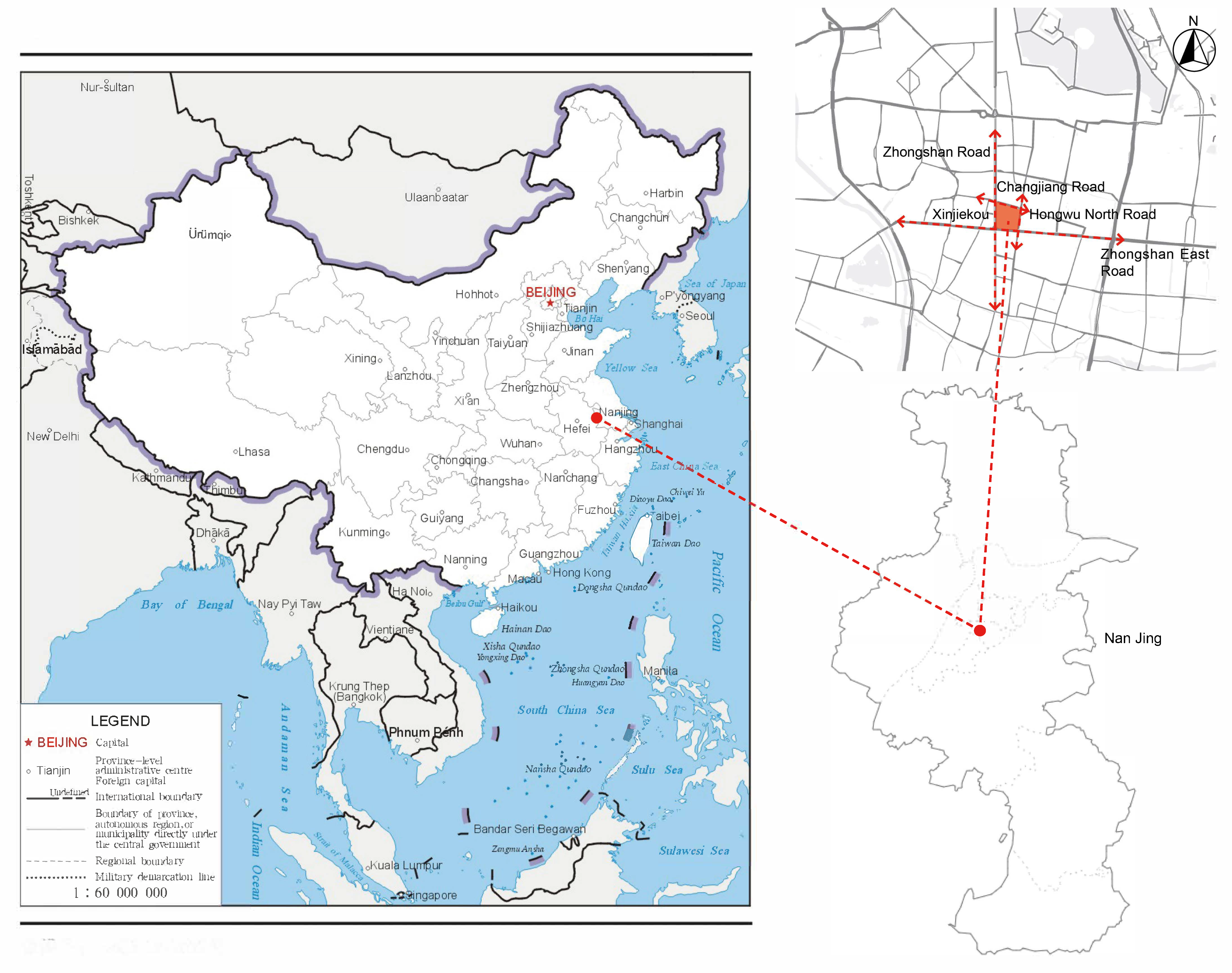
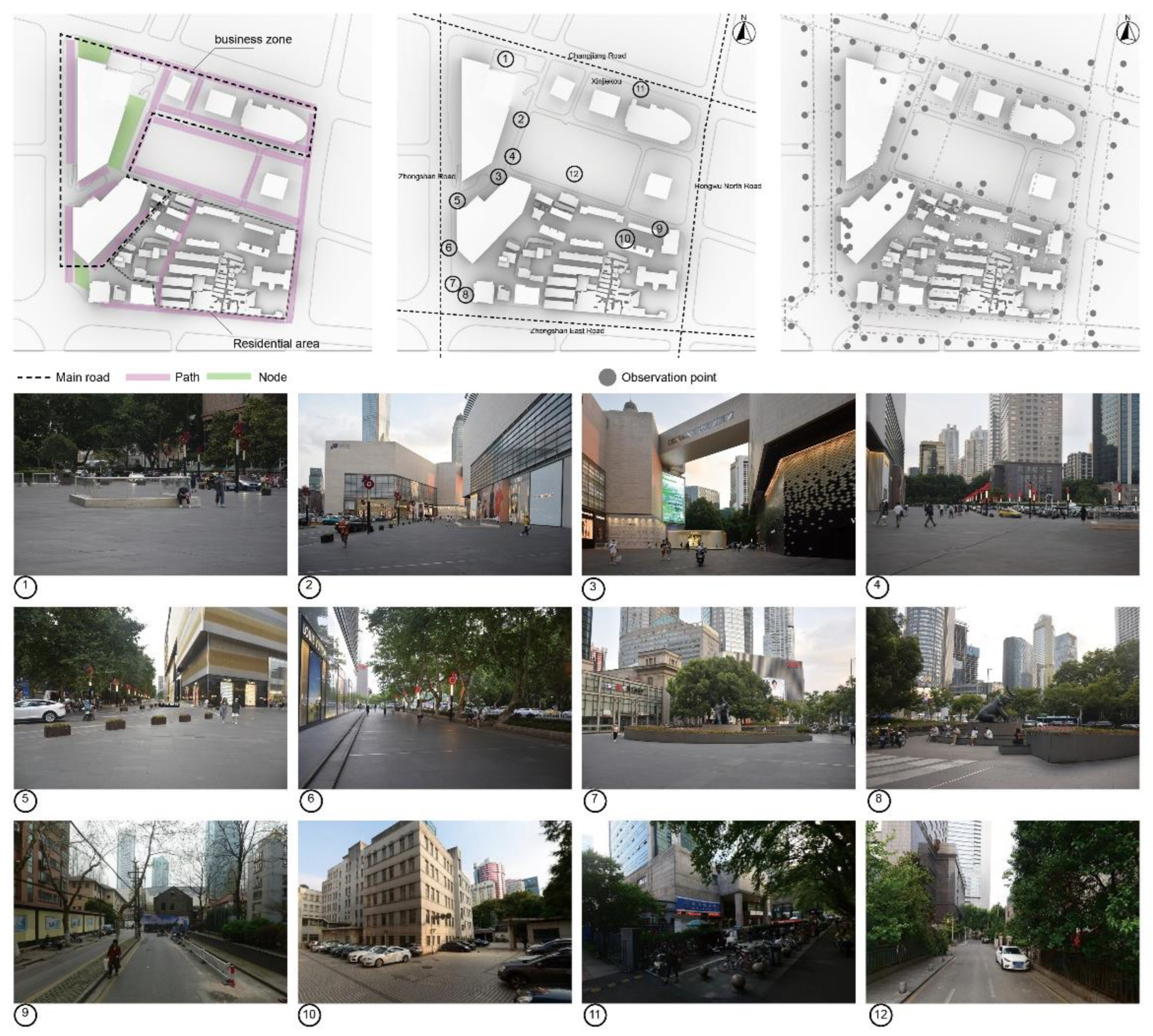
The site of this research is located in the northeast area of Xinjiekou which is adjacent to Zhongshan Road to the west, Hongwu North Road to the east, Zhongshan East Road to the south, and Changjiang Road to the north (
Figure 1). The formation of the northeast area spatial pattern of Xinjiekou is directly related to the opening of Zhongshan Road and Zhongshan East Road in 1928. Guofu road to the north (now Changjiang Road), Hongwu North Road to the east, and the important internal channels such as Tangfang bridge and Qingshi street have always been there since the beginning of development. By 1929, the fundamental layout of the northeast area was established, basically tallying with the time when the pattern of the Xinjiekou area was formed.
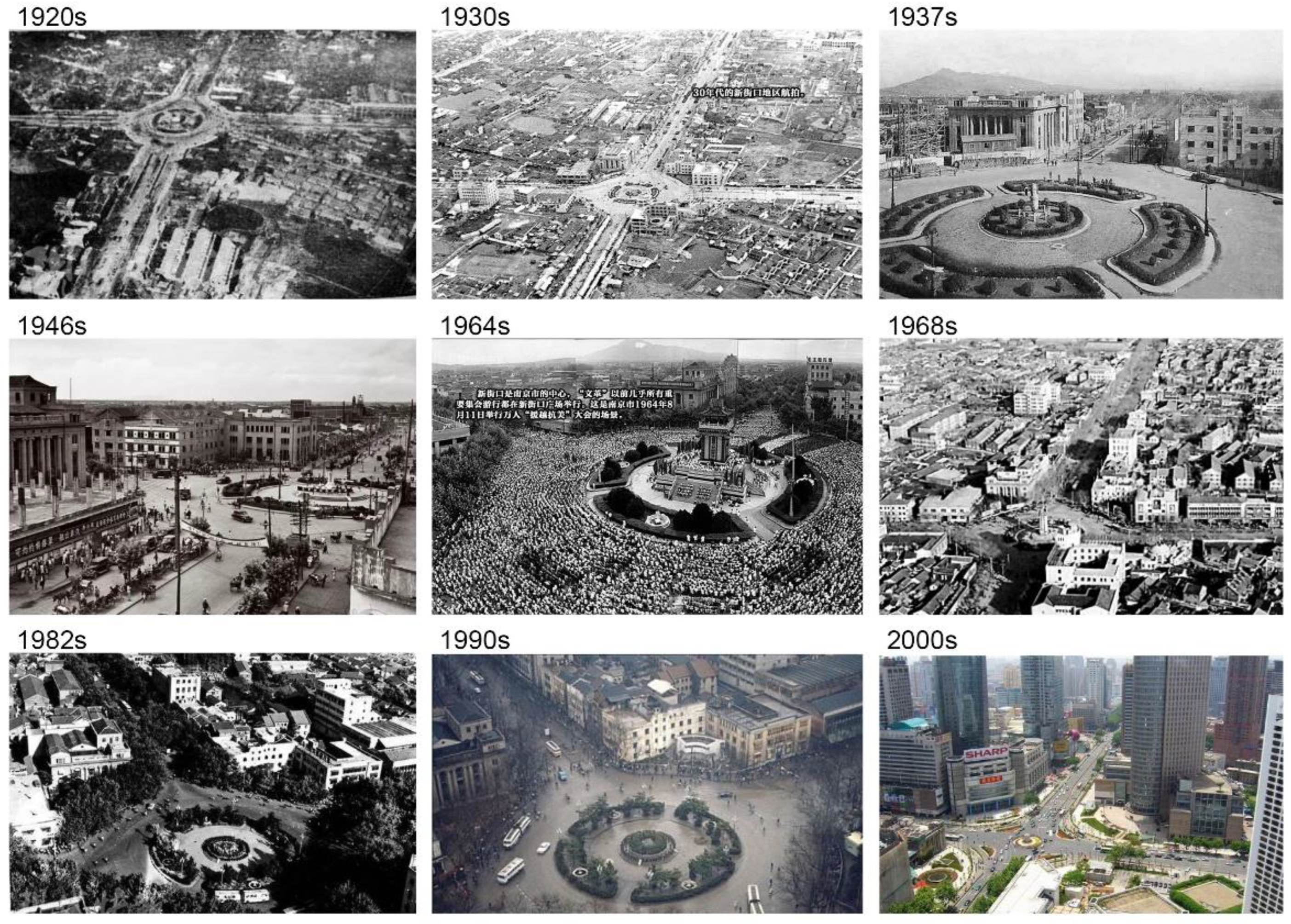
The name “Xinjiekou” can be traced back to the early Ming Dynasty (1368s). In 1928, Zhongshan Road, Zhongshan East Road, Zhongshan South Road, and Hanzhong Road were built before Dr. Sun Yat-sen’s coffin was brought back to be buried at the mausoleum on Zijin Mountain. At the intersection of these roads, a ring square with a statue of Sun Yat-sen was set up. It was then that the basic pattern of Xinjiekou area took shape. In its 90 years of expansion and development, the area has also been affected by the structural changes of urban morphology (
Figure 2).
After the outbreak of the World War Ⅱ in 1937, urban development entered a state of chaos. Xinjiekou once became an important window for political promotion. From the 1950s to 1980s, the fragmented retail businesses in Xinjiekou were replaced by large department stores, so that a neat and uniform business pattern was initially formed. The evolution of the spatial structure of Xinjiekou at this stage was characterized by the outward expansion of the built-up area. Building density was enhanced from the street to the interior of the parcel, and the proportion of commercial business land grew significantly.
In the 1990s, China began rapid urbanization. The urban fabric of Xinjiekou area radiated to the surrounding area, which marked the subdivision of business office functions and the emergence of the central business district.
Figure 2 shows the historical changes in the spatial organization of Xinjiekou and its surroundings between 1920s and 2020s. It gradually shifted from a plaza with a high level of public participation to a plaza–pedestrian public space with mainly motorized traffic and indirect participation of the residents, and eventually to a public space for walking only. The residents’ participation and identity gradually decreased. The space is gradually segmented and the sense of belonging is gradually fragmented.
4. Research Methodology
As previously described, the public nature of cities is characterized by public participation in everyday life, thus accessibility is theoretically beneficial in shaping the public nature of space and the typology of space is also seen as an effective way to increase the participation of residents [
11,
29,
30]. Therefore, the objective of this study is to obtain correlations between the distribution of people’s activities in a site and the organization of accessibility and space-typologies [
28].
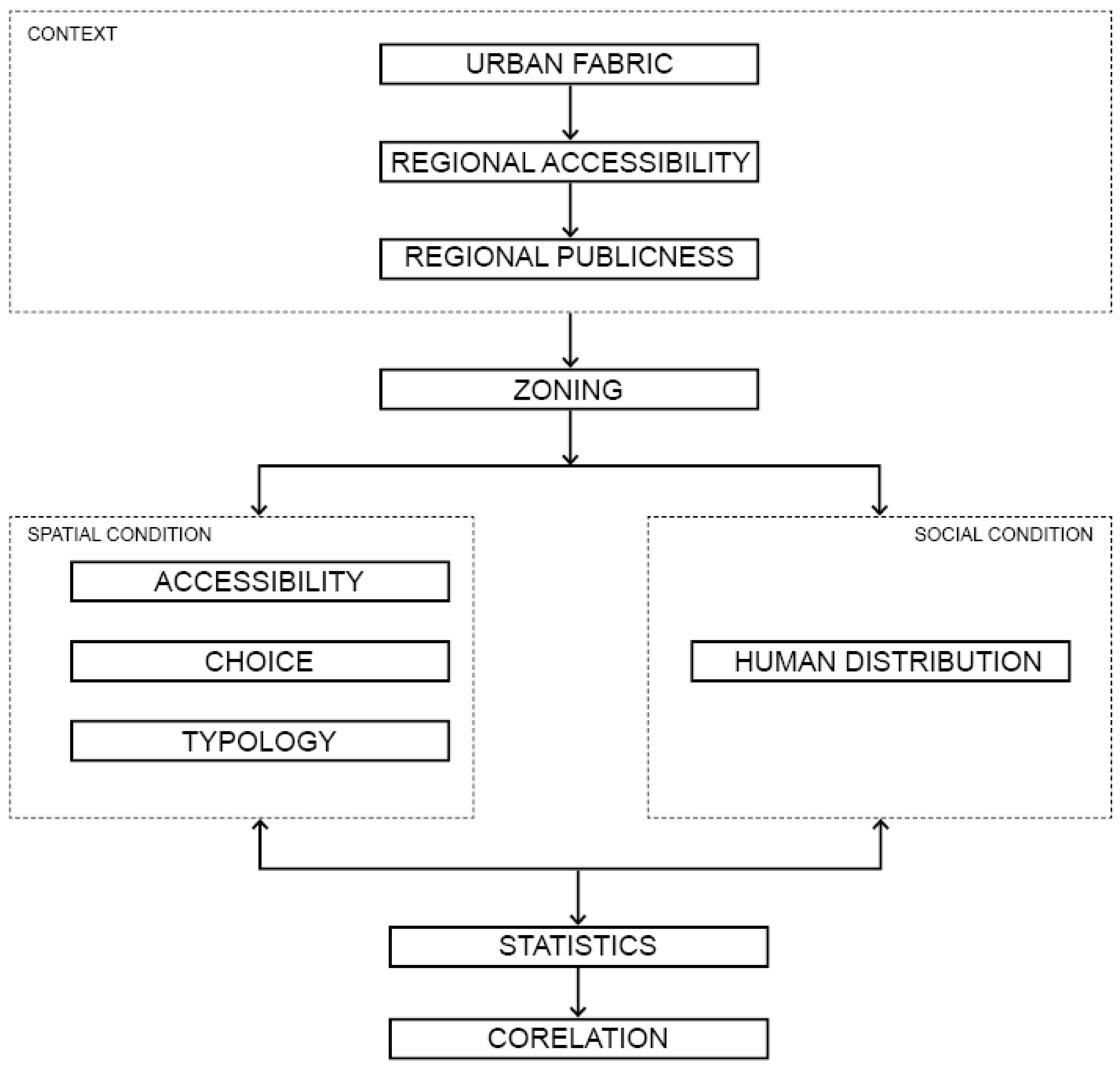
In order to understand the site more comprehensively, this study is divided into two steps (
Figure 3). First, we will analyze the evolution of the spatial structure of the site in order to obtain the spatial accessibility, and this step aims to obtain the potential of public participation at a larger scale. If the sites selected for this study have a high accessibility in the urban evolution and a high and low distribution of task activities within the sites, then zoning the different spatial types and comparing them will be meaningful. The transition from the scale of the context in which the site is located to the site and the local scale of the site will allow us to better understand the association between spatial form and publicness (
Table 1).
The second step is zoning into the site itself. The first step is to observe the scene and map the spatial distribution of people. In this study, observation points were identified and photographed and counted every 50 m along the paths within the site. The more people are active in a certain location, the more publicness is demonstrated. Secondly, we classify the public spaces in the site and analyze their intermediate centrality. The gentle transition of the intermediate centrality of the spatial form indicates good connectivity and a coherent spatial experience for the residents, which is conducive to the creation of publicness in the space. Secondly, the accessibility of different spaces is analyzed to show the potential of residents’ participation. Finally, the correlation between the number of public participants and the mediated centrality and accessibility is determined statistically.
Since this project is based on a positive design, we compare accessibility and mediated centrality before and after the design to predict the effect of spatial design on reshaping the publicness of the space. The space and its adjacent spaces will become more coherent and accessible, thus shaping an urban space that has the potential to become a public realm.
In analyzing accessibility and mediated centrality metrics, this study uses Space Syntax. Space Syntax, proposed originally by Professor Hillier, aims to systematically depict the interaction between individuals and their society and environment. The heterogeneity of space and everyday life is described by quantifying the configurational characteristics and scales of urban space [
37,
41]. The statistical method uses Geographically Weighted Regression (GWR) to determine the degree of fitness and confidence of the variables. GWR, proposed by Professor Fotheringham, can reduce the influence of location distribution on the statistical results and show the correlation characteristics of variables in a local group compared to the traditional ordinary least squares [
47,
48].
5. Results and Discussion
5.1. Context of the Spatial Organization of Xinjiekou
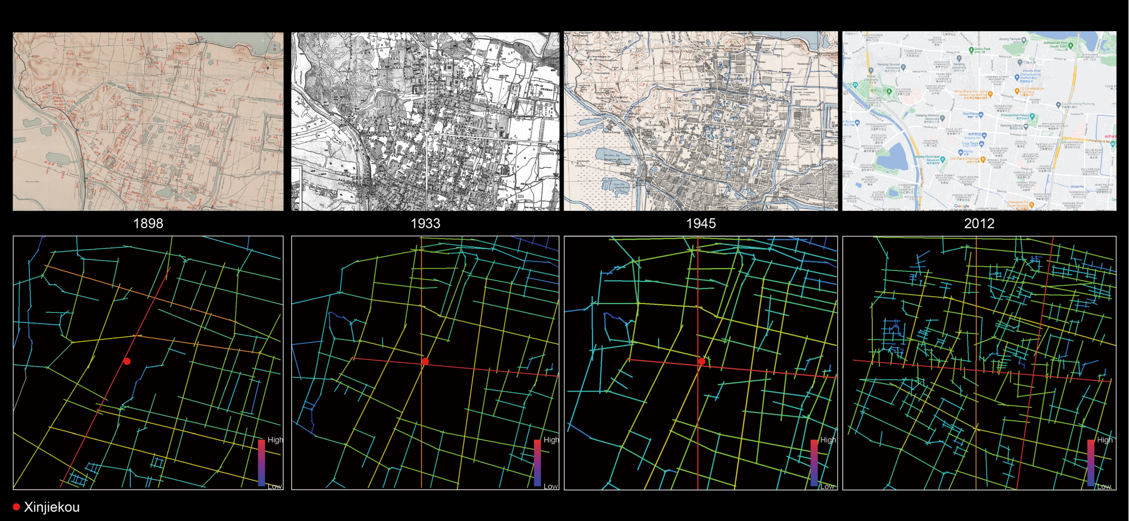
As mentioned earlier, the spatial organization of Xinjiekou underwent a politicized and commercialized transformation during the historical development of the city’s central district. The newly opened road in 1928 gradually became the center of the entire city’s central district. The results of the analysis according to Space Syntax reflect the gradual strengthening of the INTEGRATION of the northeast part of Xinjiekou from 1898 to 1933 to 1945 (
Figure 2 and
Figure 4). This indicates that the physical accessibility of the Xinjiekou area gradually improved, allowing more access for city residents. At the same time, the location of Xinjiekou has maintained a high accessibility from 1945 to 2012, and the historical images in
Figure 4 show that Xinjiekou has had a high level of public participation for a long time. The square of Xinjiekou has also become an important public space for political demonstrations and rallies.
The accessibility of Xinjiekou and its context indicates the possibility of public participation on a regional scale, i.e., in a location that is easily accessible to the public and where daily activities are frequent. However, the scale of this macro-analysis is too large, ignoring the impact of local space shaping on the individual participants and on the cognition of human scale. It is meaningful to discuss the public participation in Xinjiekou base in this context, because the high accessibility and high participation attributes make this study representative of a post-zoning analysis of its spatial characteristics [
4,
11].
5.2. Correlation of Public Participation with Choice and Integration in the Northeast Area of Xinjiekou
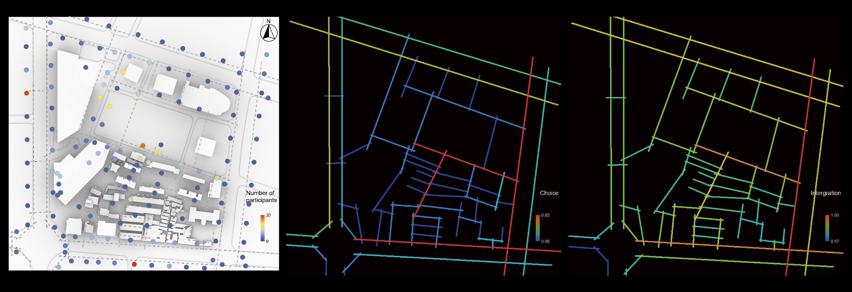
As mentioned in the research methodology, we first made a comprehensive observation of the site after zoning to the Xinjiekou area. As shown in the
Figure 5 and
Figure 6, a total of 146 observation points were selected for this study, and the location and number of people passing by were photographed to record their activities. The original space of Xinjiekou after the simple renovation in 2012 was a mixed-use pattern of commercial building space, residential buildings, and traditional residential houses.
In this study, we divided public spaces into two categories. The first category was path, a type of space in which the public participates by walking, with little stopping, and the width of the path is within 3–10 m and the length is between 50–500 m. The location is usually on one side of the building with a small amount of landscape. The second type of space is node, where the public participates in more diverse ways, socializing, stopping, resting, etc. Its size is 50 m × 50 m or more, which can create plazas, gardens, etc.
By observation, the spatial ratio is partially imbalanced, with commercial building spaces large and orderly, and residential buildings small and scattered, and the spatial sequence is in a fractured state. The commercial and residential spaces are self-contained and lack integrity. The public space connecting the different physical spaces is reduced to a non-architectural public domain, where residents rarely stop, walk, and move around, and have a low sense of belonging. From the diagram, we can see that the distribution of characters is mainly located in the central paths of the site and at the entrances and exits of some of the plots. At the same time the distribution of locations of higher public participation is disorderly and discontinuous.
At the same time, we analyzed the integration and choice of the site (
Figure 6). According to the analysis results, we can see that the paths with higher choice are located around the base, and the overall choice of the site is low, while the center is special as a bridge between residential and commercial areas with higher choice. The accessibility analysis results show that, except for the residential paths with lower accessibility, the accessibility of the rest of the commercial locations is more homogeneous.
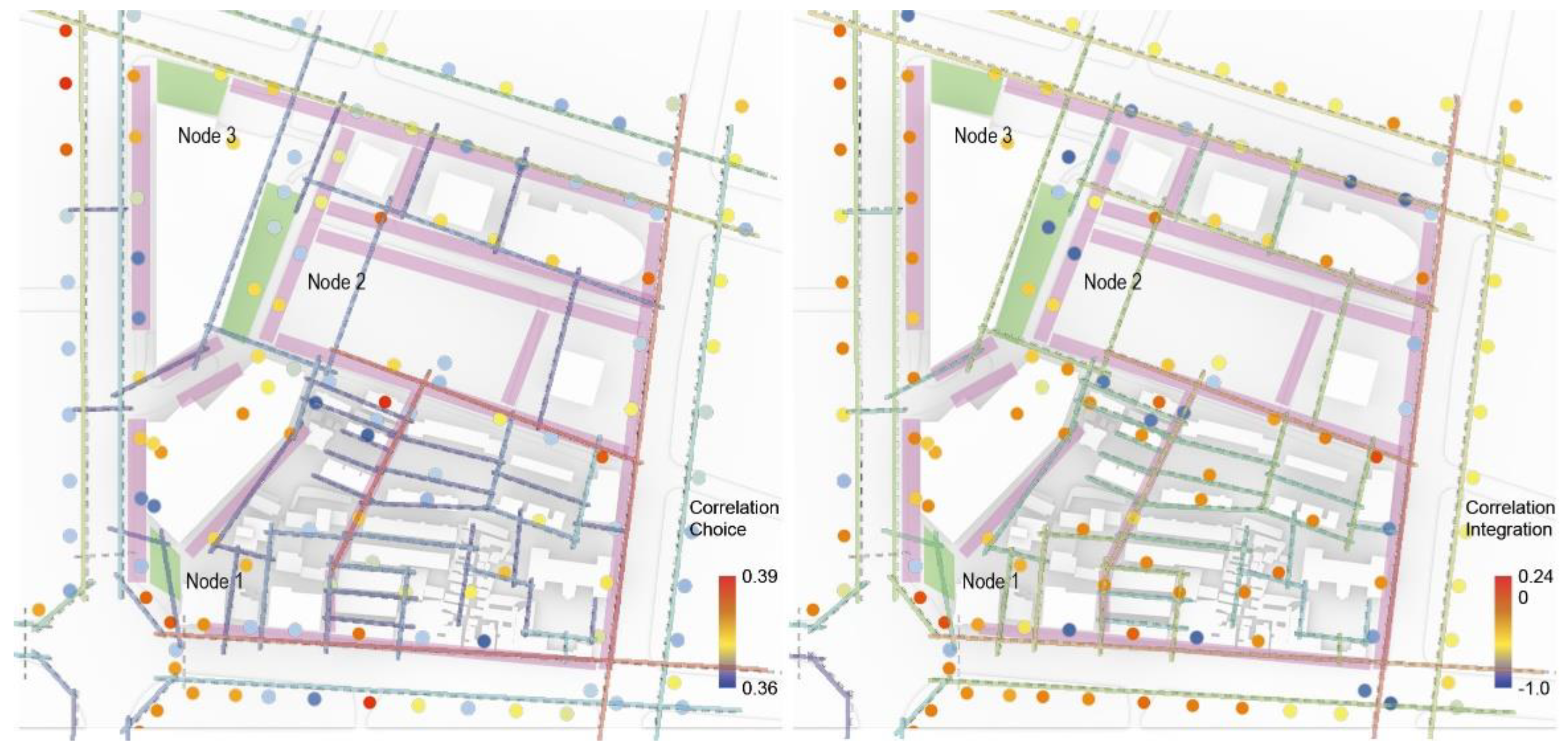
Based on this, we used GWR to analyze the correlation between the number of public participants, choice, and integration (
Table 2 and
Figure 7). At the same time, we can see that the R2 of the model fit is 0.392, and the fit of the model constructed by choice, integration, and the number of participants is relatively average. The number of effective parameters (ENP) is 13.801, which indicates that there are still variables not considered in the model except for choice and integration. And the p value of the variable is less than 0.01, indicating that the analysis result is very important. Meanwhile, the overall effect of choice on public participation is positively correlated, while the overall effect of integration on public participation is negatively correlated, which is different from what we usually think. This (
Figure 6 and
Figure 7) suggests that in small-scale neighborhoods, the coherence of the paths will drive public participation, while the accessibility of the paths does not drive residents to participate in the activities on the site, thus making the public space lose its publicness.
In addition, among the spatial types of paths (
Figure 6 and
Figure 7), the overall performance is that high accessibility presents a positive correlation with public participation when the paths with higher choices are connected. Accessibility presents a negative correlation with public participation when the paths are not connected. In the spatial type of node, choice–integration correlation is consistent with node correlation, so the strategy to promote public participation in the spatial type of node should be adopted to increase choice–integration in parallel.
5.3. Pedestrian Flow Design Strategy for Xinjiekou Public Space
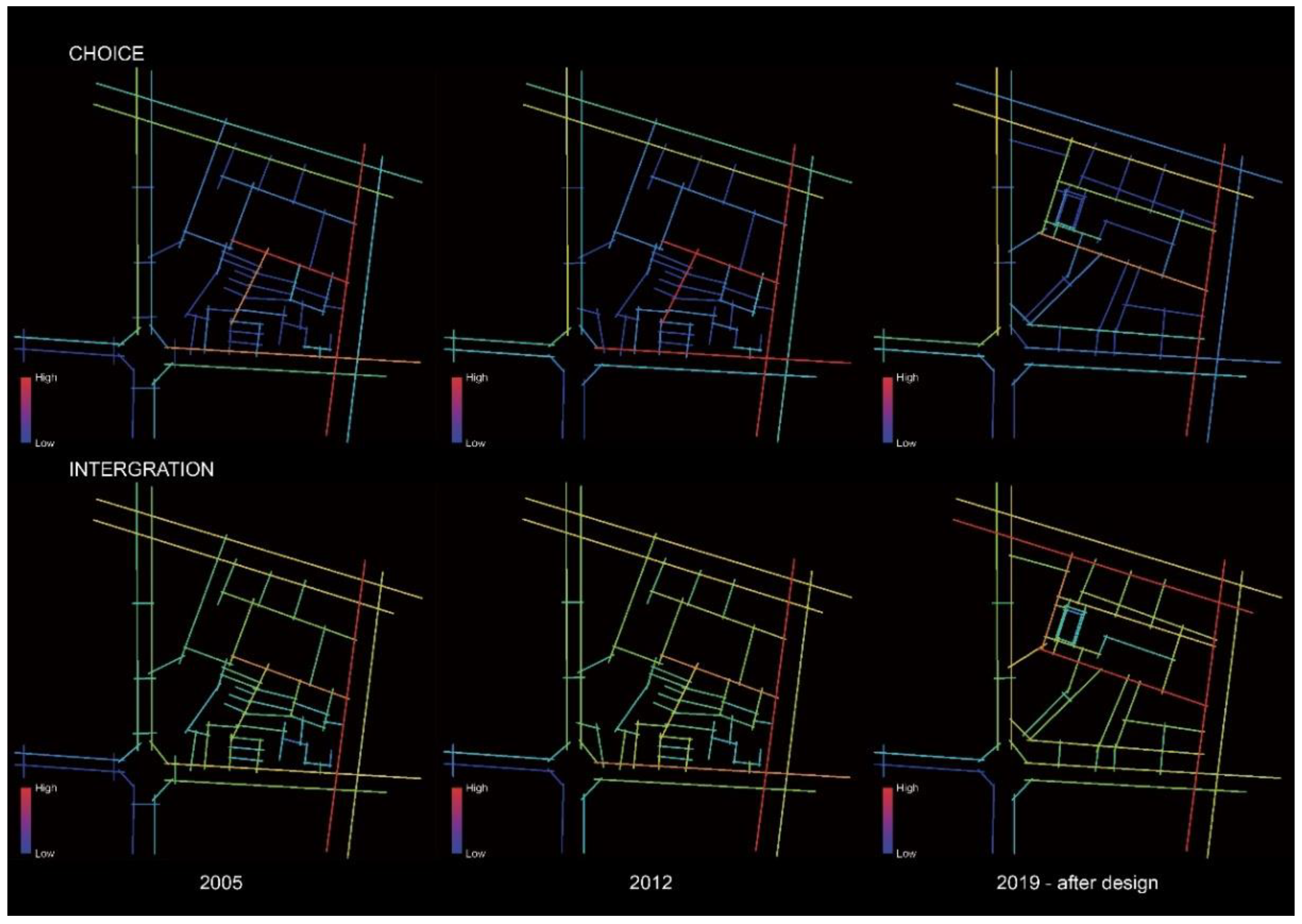
The design reconfigured the pedestrian flow based on the correlation between public participation and choice and integration as summarized by the site. We retraced the choice and integration of traffic on the site from 2005 to 2012, and the overall spatial organization remained unchanged except for the closure of pedestrian access around the road intersection (
Figure 8). The choice of pedestrian flow in the site is locally enhanced and the paths of high choice are not coherent, and the accessibility of pedestrian flow in the site has been improved. Based on the previous analysis, we can understand that in this case the public participation of the residents will be weakened, thus weakening the public nature of the public space of the site.
Based on the above analysis, we can understand that the public participation of the residents will be weakened in this case, thus weakening the public space of the site. According to the analysis results, we can find that the choice-value of the pedestrian flow is higher and the paths with high choice-value are more coherent. At the same time, the integration of these paths has also improved significantly. Based on the previous analysis, we believe that the public space in this case has increased the potential for residents to participate in the site, thus increasing the public nature of the public space.
In conclusion, this study developed an urban design strategy based on field observations and quantitative analysis of Space Syntax. We created the publicness of public spaces in urban centers by developing situational strategies based on an understanding of the evolutionary characteristics of urban organization. In addition to satisfying functional use, it increases the possibility of interaction and communication between residents.
6. Conclusions
Many of China’s urban design strategies tend to position themselves in terms of commercial value and neglect the creation of the human element of urban life. This has led to increasing social separation and a loss of the sense of urban belonging. This has had a negative impact on both the city and its residents. We believe that full awareness of the potential needs of society and future development is an important prerequisite for design. In this study, we also argue Sadeghi, Abarkan, and Yang et al. that urban form explains to some extent the logic of urban function, that spatial-typology interacts with social conditions and can provide for the shaping of public life and publicness of space [
24,
25,
41].
In this study, we first examined Xinjiekou in its contexts through the Space Syntax method to verify whether the smaller area selected for the study was representative of the study framework. Second, through the quantitative analysis of Space Syntax and social observations, it was determined that public participation tends to choose walking paths with a higher number of shortest paths through a location and that these locations are interconnected. Under this condition, accessibility has a catalytic effect on public participation. If these high-choice walking paths are not connected, residents are less likely to choose such areas for their activities. Later in the design, we organized the pedestrian circulation in the site based on the findings of the analysis, thus contextualizing, and enhancing, the possibilities and potential for future residents to participate in the daily life of the public space.
In this paper, the study provides a pre-feasibility hypothesis for the design that combines the correlation between the quantitative analysis of spatial morphology and the spatial distribution characteristics of social phenomena to construct a public participation-oriented cognitive framework of urban morphology. The method not only effectively delineates the interaction process of minute forms to the overall human–spatial, but also has a statistical-based verification process with high interpretability and confidence. The designs generated based on this framework are expected to facilitate the evolution of public space into the public realm upon completion. We hope that this combination of observation and quantitative analysis will validate and optimize design theory in anticipation of enhanced placemaking in urban public spaces to improve the lives of residents.
The current study has the following shortcomings that we hope to explore in future research.
This study only considered the analysis of integration and choice of public spaces while the number of potential variables exceeded the number of predetermined variables by a large margin according to the statistical diagnosis results, which indicates that other elements in the built environment still influence residents’ choices. For example: different services and functions;
The fitness between the variables in this statistical model in the study is not excellent; based on experience, it is possible that the spatial distribution of distance has an impact on the analysis results, and later studies will consider optimizing the impact of location distance on the model fitness.
Author Contributions
Conceptualization, M.P.; methodology, M.P.; software, Y.S.; investigation, M.P., Y.S. and Q.J.; resources, Q.Z.; data curation, Q.Z. and Y.L.; writing—original draft preparation, M.P.; writing—review and editing, M.P.; visualization, M.P.; supervision, Q.Z. and Y.L.; project administration, Q.Z. and Y.L.; funding acquisition, Q.Z. and Y.L. All authors have read and agreed to the published version of the manuscript.
Funding
This research was supported by the Architects and Engineers Associates of Southeast University (No. 51778123).
Institutional Review Board Statement
Since this study did not involve personal privacy nor questionnaires, etc., and only the authors’ own observations were used as data collection, ethical approval was not applicable.
Informed Consent Statement
Informed consent was obtained from all subjects involved in the study.
Data Availability Statement
Not applicable.
Conflicts of Interest
The authors declare no conflict of interest.
References
- The UIA Beijing Charter. J. Archit. 2000, 5, 1–8. [CrossRef]
- Arentze, T.A.; van der Waerden, P.J.H.J.; Bergen, J.W.; Timmermans, H.J.P. Measuring the Quality of Urban Environments: A Need-Based Micro-Simulation Approach. Appl. Spat. Anal. Policy 2009, 2, 195–209. [Google Scholar] [CrossRef][Green Version]
- Afonso, A.G.; Ergin, E.; Fatah gen. Schieck, A. Flowing Bodies: Exploring the Micro and Macro Scales of Bodily Interactions with Urban Media Installations. In Proceedings of the 2019 on Designing Interactive Systems Conference (DIS ‘19), San Diego, CA, USA, 23–28 June 2019; Association for Computing Machinery: New York, NY, USA, 2019; pp. 1183–1193. [Google Scholar] [CrossRef]
- Ye, C.; Hu, L.; Li, M. Urban green space accessibility changes in a high-density city: A case study of Macau from 2010 to 2015. J. Transp. Geogr. 2018, 66, 106–115. [Google Scholar] [CrossRef]
- Al-Kodmany, K. Placemaking with tall buildings. Urban Des. Int. 2011, 16, 252–269. [Google Scholar] [CrossRef]
- Friedmann, J. Place and Place-Making in Cities: A Global Perspective. Plan. Theory Pract. 2010, 11, 149–165. [Google Scholar] [CrossRef]
- Gu, K.; Li, Y.; Zheng, X. A typological approach to planning. J. Urban. Int. Res. Placemaking Urban Sustain. 2019, 12, 373–392. [Google Scholar] [CrossRef]
- Jacobs, J. Death and Life of Great American Cities; Random House: New York, NY, USA, 1961; p. 474. [Google Scholar]
- Najafi, P.; Mohammadi, M.; Le Blanc, P.M.; van Wesemael, P. Insights into placemaking, senior people, and digital technology: A systematic quantitative review. J. Urban. 2022, 1–30. [Google Scholar] [CrossRef]
- Gehl, J.; Matan, A. Two perspectives on public spaces. Build. Res. Inf. 2009, 37, 106–109. [Google Scholar] [CrossRef]
- Le Texier, M.; Schiel, K.; Caruso, G. The provision of urban green space and its accessibility: Spatial data effects in Brussels. PLoS ONE 2018, 13, e0204684. [Google Scholar] [CrossRef]
- Kropf, K. Urban tissue and the character of towns. Urban Des. Int. 1996, 1, 247–263. [Google Scholar] [CrossRef]
- Banerjee, T. The Future of Public Space: Beyond Invented Streets and Reinvented Places. J. Am. Plan. Assoc. 2001, 67, 9–24. [Google Scholar] [CrossRef]
- Knox, P.L. Creating Ordinary Places: Slow Cities in a Fast World. J. Urban Des. 2005, 10, 1–11. [Google Scholar] [CrossRef]
- Miao, P. Brave New City: Three Problems in Chinese Urban Public Space since the 1980s. J. Urban Des. 2011, 16, 179–207. [Google Scholar] [CrossRef]
- Wu, F. Planning centrality, market instruments: Governing Chinese urban transformation under state entrepreneurialism. Urban Stud. 2018, 55, 1383–1399. [Google Scholar] [CrossRef]
- Lefebvre, H.; Nicholson-Smith, D.; Lefebvre, H. The Production of Space; Blackwell Publishing: Malden, MA, USA, 1991; ISBN 978-0-63118-177-4. [Google Scholar]
- Resmini, A.; Rosati, L. Place-making. In Pervasive Information Architecture; Elsevier: Amsterdam, The Netherlands, 2011; pp. 63–87. ISBN 978-0-12382-094-5. [Google Scholar]
- Stedman, R.C. Is It Really Just a Social Construction?: The Contribution of the Physical Environment to Sense of Place. Soc. Nat. Resour. 2003, 16, 671–685. [Google Scholar] [CrossRef]
- Lang, J. The Place Shaping Continuum: A Theory of Urban Design Process. J. Urban Des. 2014, 19, 2–36. [Google Scholar] [CrossRef]
- Lynch, K. The Image of the City; Publication of the Joint Center for Urban Studies; M.I.T. Press: Cambridge, UK, 1960; ISBN 978-0-26212-004-3. [Google Scholar]
- Akkar, M. The changing ‘publicness’ of contemporary public spaces: A case study of the Grey’s Monument Area, Newcastle upon Tyne. Urban Des. Int. 2005, 10, 95–113. [Google Scholar] [CrossRef]
- Kulesza, M. Conzenian Tradition in Polish Urban Historical Morphology. Eur. Spat. Res. Policy 2015, 21, 133–153. [Google Scholar] [CrossRef]
- Sadeghi, G.; Li, B. Urban Morphology: Comparative Study of Different Schools of Thought. Curr. Urban Stud. 2019, 7, 562–572. [Google Scholar] [CrossRef]
- Abarkan, A. Typo-morfologi: Metoden och dess tillämpning på bebyggelsesmönster. Nordic J. Archit. Res. 2013, 13, 1–2. [Google Scholar]
- Yang, Y.; Kossak, F. Building Typology as a Generator of Urban Form for Urban Design Project. Cities Assem. 2022, 1, 147–159. [Google Scholar] [CrossRef]
- Yılmaz Çakmak, B.; Topçu, M. An evaluation of urban open spaces in Historical City Center of Konya in the context of pedestrian mobility. J. Hum. Sci. 2018, 15, 1827–1846. [Google Scholar] [CrossRef]
- Stanley, B.W.; Stark, B.L.; Johnston, K.L.; Smith, M.E. Urban Open Spaces in Historical Perspective: A Transdisciplinary Typology and Analysis. Urban Geogr. 2012, 33, 1089–1117. [Google Scholar] [CrossRef]
- Zhou, X.; Parves Rana, M. Social benefits of urban green space: A conceptual framework of valuation and accessibility measurements. Manag. Environ. Qual. Int. J. 2012, 23, 173–189. [Google Scholar] [CrossRef]
- Lotfi, S.; Koohsari, M.J. Analyzing Accessibility Dimension of Urban Quality of Life: Where Urban Designers Face Duality Between Subjective and Objective Reading of Place. Soc. Indic. Res. 2009, 94, 417–435. [Google Scholar] [CrossRef]
- Yavuz, A.; Kuloğlu, N. Permeability as an indicator of environmental quality: Physical, functional, perceptual components of the environment. World J. Environ. Res. 2014, 4, 13. [Google Scholar]
- Öztürk, S.; Işinkaralar, Ö.; Ayan, E. Visibility Analysis in Historical Environments: The case of Kastamonu Castle and its Surrounding. J. Curr. Res. Soc. Sci. 2018, 8, 405–412. [Google Scholar]
- Thirumaran, K.; Balaji, G.; Prasad, N.D. (Eds.) Sustainable Urban Architecture: Select Proceedings of VALUE 2020; Lecture Notes in Civil Engineering; Springer: Singapore, 2021; Volume 114, ISBN 978-9-81159-584-4. [Google Scholar]
- Mahendra, I.M.A.; Paturusi, S.; Dwijendra, N.K.A. The meaning of local culture elements and urban elements as forming the identity of the klungkung urban area, Bali, Indonesia. PalArch’s J. Archaeol. Egypt/Egyptol. 2020, 17, 11563–11580. [Google Scholar]
- Batty, M.; Desyllas, J.; Duxbury, E. The discrete dynamics of small-scale spatial events: Agent-based models of mobility in carnivals and street parades. Int. J. Geogr. Inf. Sci. 2003, 17, 673–697. [Google Scholar] [CrossRef]
- Liu, H.; Silva, E.A.; Wang, Q. Creative Industries and Urban Spatial Structure: Agent-Based Modelling of the Dynamics in Nanjing; Springer International Publishing AG: Berlin, Germany, 2015. [Google Scholar]
- Hillier, B.; Tzortzi, K. Space Syntax. In A Companion to Museum Studies; Macdonald, S., Ed.; Blackwell Publishing Ltd.: Malden, MA, USA, 2006; pp. 282–301. ISBN 978-0-47099-683-6. [Google Scholar]
- Netto, V.M. ‘What is space syntax not?’ Reflections on space syntax as sociospatial theory. Urban Des. Int. 2016, 21, 25–40. [Google Scholar] [CrossRef]
- Delso, J.; Martín, B.; Ortega, E. A new procedure using network analysis and kernel density estimations to evaluate the effect of urban configurations on pedestrian mobility. The case study of Vitoria–Gasteiz. J. Transp. Geogr. 2018, 67, 61–72. [Google Scholar] [CrossRef]
- Yang, J.; Zhu, J.; Sun, Y.; Zhao, J. Delimitating Urban Commercial Central Districts by Combining Kernel Density Estimation and Road Intersections: A Case Study in Nanjing City, China. ISPRS Int. J. Geo-Inf. 2019, 8, 93. [Google Scholar] [CrossRef]
- Freeman, L.C. Centrality in social networks conceptual clarification. Soc. Netw. 1978, 1, 215–239. [Google Scholar] [CrossRef]
- Zeng, R.; Shen, Z. Post-Occupancy Evaluation of the Urban Underground Complex: A Case Study of Chengdu Tianfu Square in China. J. Asian Archit. Build. Eng. 2022, 1–16. [Google Scholar] [CrossRef]
- Zhang, S.; Yu, P.; Chen, Y.; Jing, Y.; Zeng, F. Accessibility of Park Green Space in Wuhan, China: Implications for Spatial Equity in the Post-COVID-19 Era. Int. J. Environ. Res. Public Health 2022, 19, 5440. [Google Scholar] [CrossRef]
- Nilufar, F. Urban Morphology of Dhaka City: Spatial Dynamics of Growing City and the Urban Core; Asiatic Society of Bangladesh: Dhaka, Bangladesh, 2010. [Google Scholar]
- Long, Y.; Gu, Y.; Han, H. Spatiotemporal heterogeneity of urban planning implementation effectiveness: Evidence from five urban master plans of Beijing. Landsc. Urban Plan. 2012, 108, 103–111. [Google Scholar] [CrossRef]
- Telega, A.; Telega, I.; Bieda, A. Measuring Walkability with GIS—Methods Overview and New Approach Proposal. Sustainability 2021, 13, 1883. [Google Scholar] [CrossRef]
- Shabrina, Z.; Buyuklieva, B.; Ng, M.K.M. Short-Term Rental Platform in the Urban Tourism Context: A Geographically Weighted Regression (GWR) and a Multiscale GWR (MGWR) Approaches. Geogr. Anal. 2021, 53, 686–707. [Google Scholar] [CrossRef]
- Oshan, T.; Li, Z.; Kang, W.; Wolf, L.; Fotheringham, A. mgwr: A Python Implementation of Multiscale Geographically Weighted Regression for Investigating Process Spatial Heterogeneity and Scale. ISPRS Int. J. Geo-Inf. 2019, 8, 269. [Google Scholar] [CrossRef]
| Publisher’s Note: MDPI stays neutral with regard to jurisdictional claims in published maps and institutional affiliations. |
© 2022 by the authors. Licensee MDPI, Basel, Switzerland. This article is an open access article distributed under the terms and conditions of the Creative Commons Attribution (CC BY) license (https://creativecommons.org/licenses/by/4.0/).


