Digital Technologies and Machine Learning in Environmental Hazard Monitoring: A Synthesis of Evidence for Floods, Air Pollution, Earthquakes, and Fires

 , , , and
Abstract
1. Introduction
2. Materials and Methods
2.1. Data Selection
- 1.
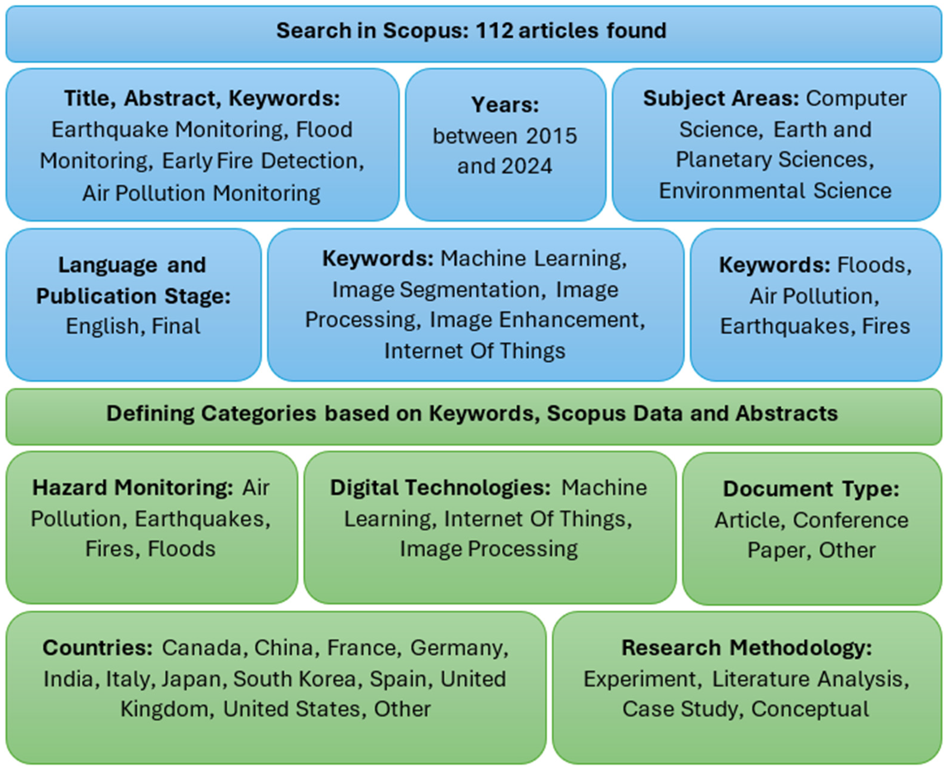
- Initial Search: The primary search query focused on hazard monitoring and digital technologies, restricted to English-language documents published between 2015 and 2024. The exact query string was as follows:
- 2.
- Refinement: The initial results were further filtered by focusing on the core keywords: air pollution, earthquakes, fires, and floods. This refinement resulted in a final dataset of 112 articles used for the qualitative synthesis and bibliometric analysis.
- –
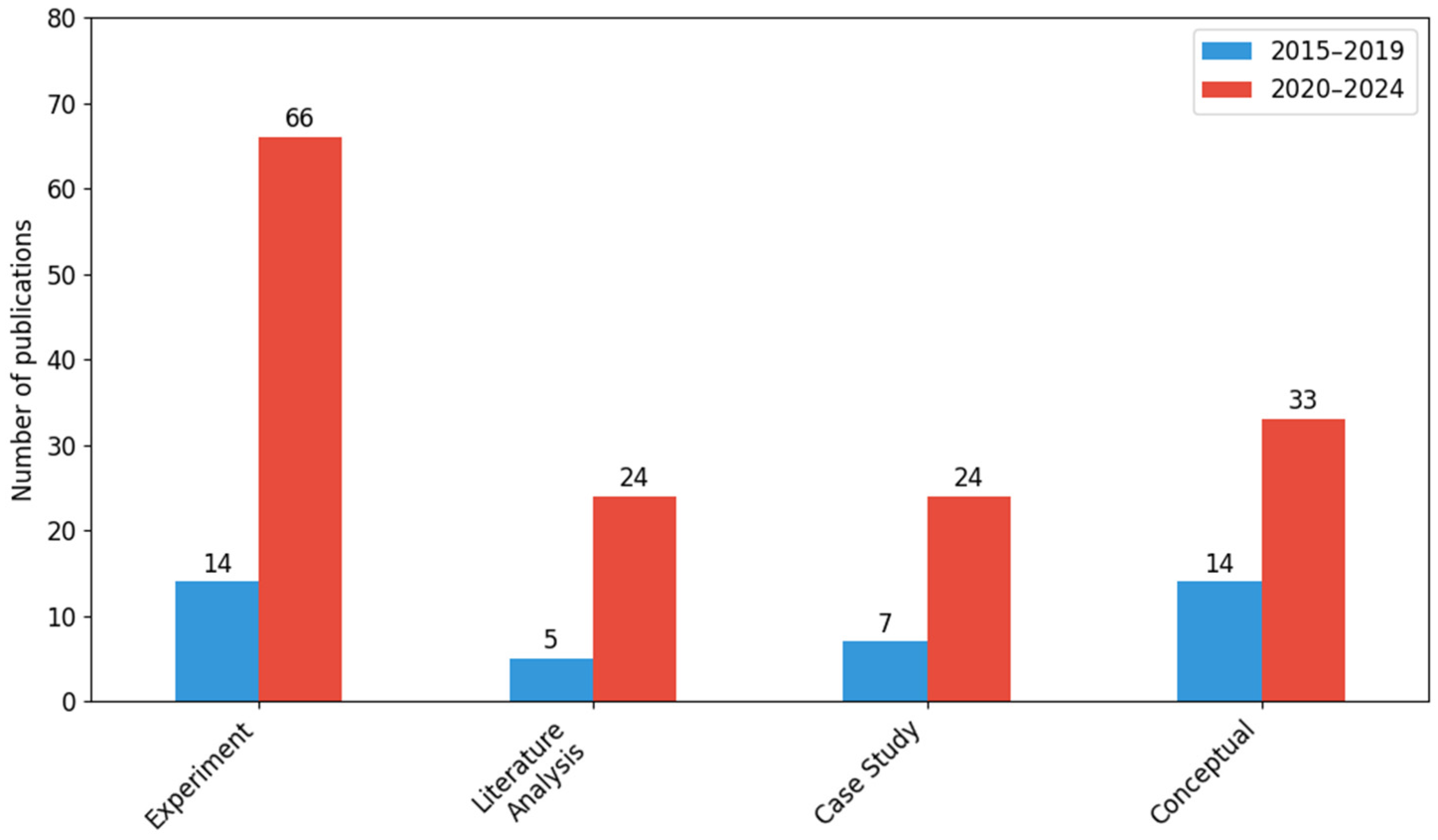
- Experiment: Studies involving primary data collection and controlled testing (e.g., laboratory testing of new low-cost gas sensors for air pollution monitoring).
- –
- Case Study: Research focused on the implementation or demonstration of a system in a specific, real-world scenario (e.g., the implementation of a specific flood early warning system in a given river basin).
- –
- Literature Analysis: Secondary research based on existing surveys, meta-analyses, or previously published data.
- –
- Conceptual: Theoretical development of models (e.g., theoretical architecture of a deep learning model for seismic wave prediction without field validation) or systemic concepts without immediate field implementation.
2.2. Data Analysis
- −
- Visual analysis of floods (image processing dominance);
- −
- Machine learning in seismology (earthquakes);
- −
- Integration of IoT with air pollution monitoring.
3. Quantitative and Qualitative Analysis of the State of the Art
- Floods;
- Air pollution;
- Earthquakes;
- Fires.
3.1. Floods
3.2. Air Pollution
3.3. Earthquakes
3.4. Fires
3.5. Summary of Literature Review
4. Statistical Overview
4.1. Document Typology
4.2. Hazard Monitoring in 2015–2019 and 2020–2024
4.3. Digital Technologies Applied (2015–2024)
4.4. Research Methodologies Applied (2015–2024)
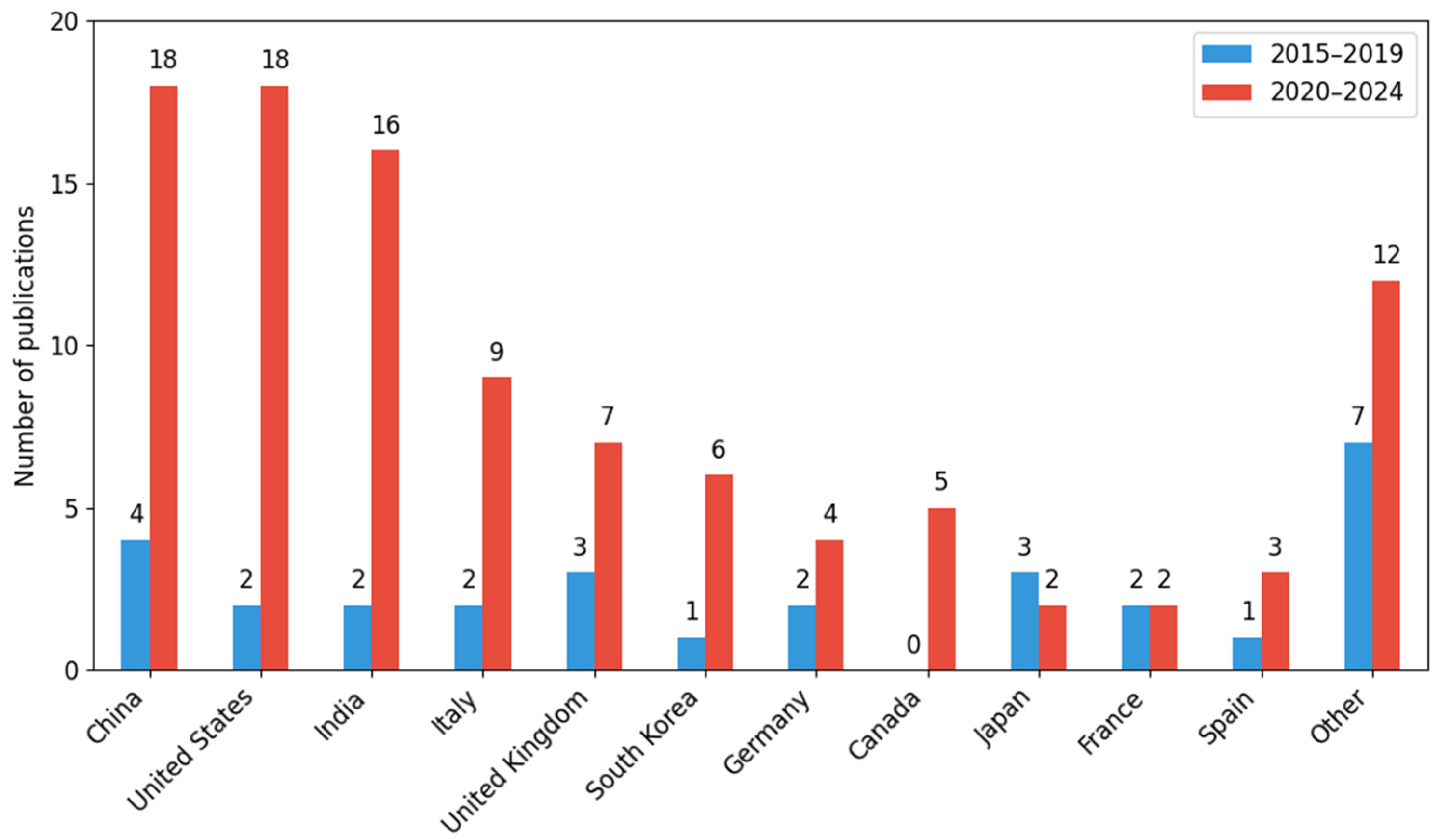
4.5. Geographical Distribution of Publications (2015–2024)
4.6. The Connection Between Threat Monitoring, Digital Technology, and Research Methodology
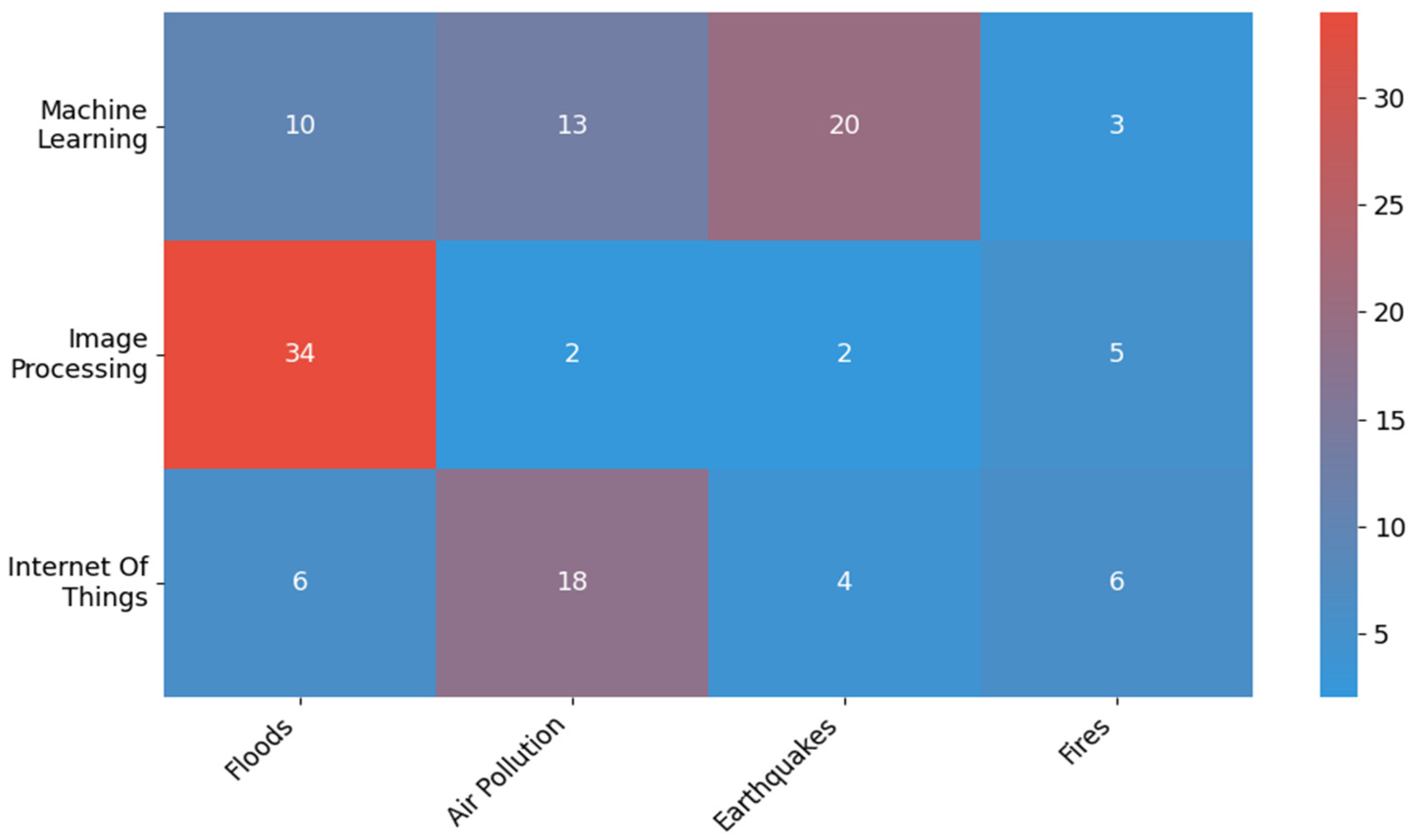
4.7. Relationship Between Digital Technologies and the Type of Threat Being Monitored
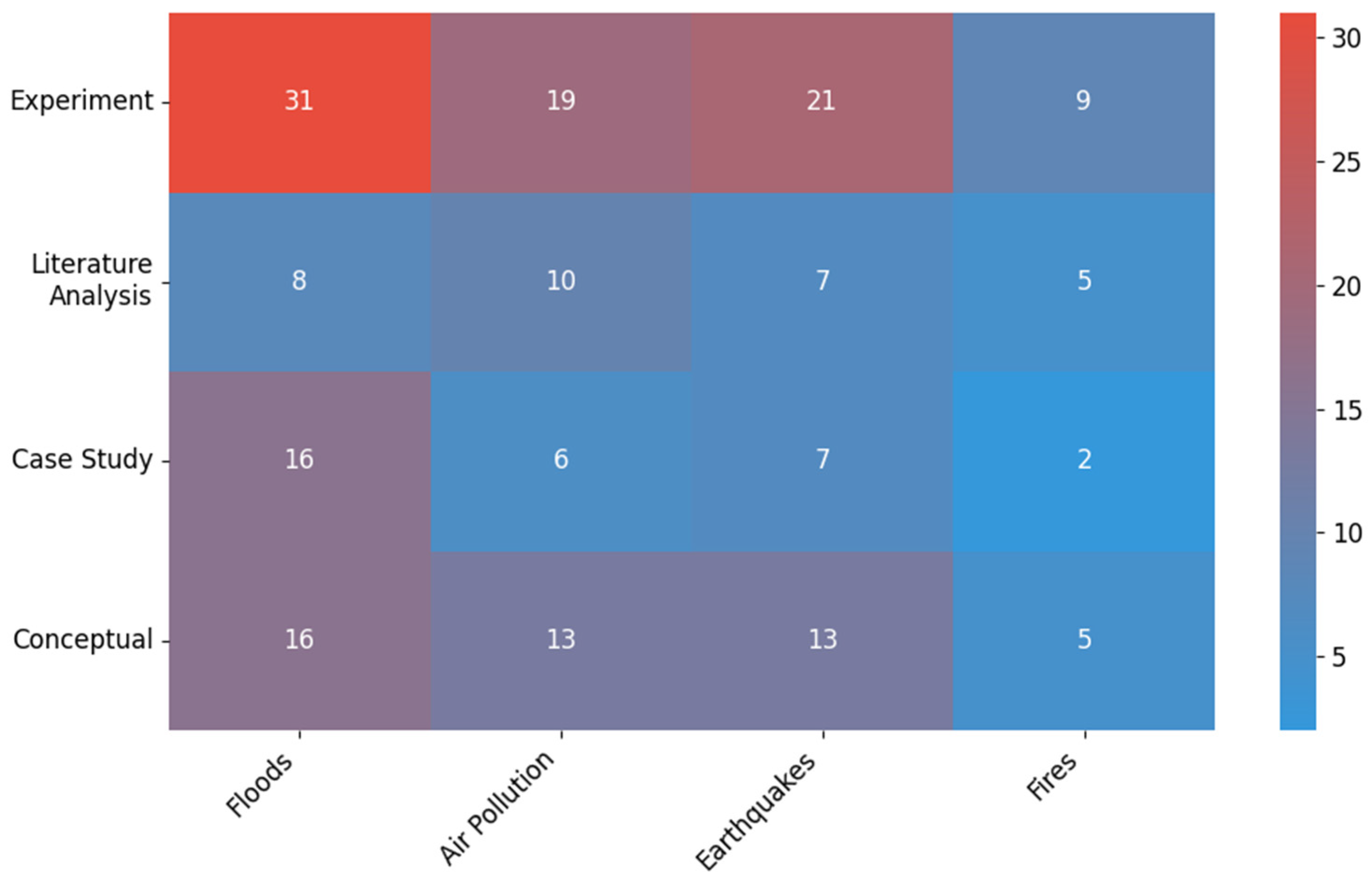
4.8. Relationship Between Research Methodologies Applied and Type of Threat Being Monitored
5. Discussion
5.1. Analysis of the Developments in Hazard Monitoring (2020–2024)
5.2. Analysis of the Application of Digital Technology
5.3. Analysis of the Research Methodologies Applied
6. Conclusions
- −
- Validation/benchmarks: There is a lack of common benchmarks and metrics; limited comparability of results; and difficult selection of methods with real operational advantage.
- −
- Generalizability: There is a dominance of case studies and limited transfer assessment; sensitivity to data shift and data gaps; and decreased reliability in critical applications.
- −
- Near real-time and implementation: There exists rare reporting of latency, infrastructure, and data quality control; incomplete assessment of “from data to decision”; and implementation barriers in warning systems.
- I.
- Floods:
- −
- There is a lack of sufficient validation of flood detection algorithms under real conditions, especially in regions with limited access to satellite data;
- −
- There is a limited number of studies integrating satellite, hydrological, and IoT data into a single, consistent predictive model;
- −
- There is insufficient analysis of the impact of climate variability on the effectiveness of current monitoring systems.
- II.
- Air pollutants:
- −
- There is insufficient research on real-time integration of data from terrestrial and satellite sensor networks;
- −
- There exists a lack of long-term research on the impact of air quality forecasts on policy decisions and public health.
- III.
- Earthquakes:
- −
- Little research has been conducted into the use of commonly available mobile devices (smartphones, consumer sensors) as elements of distributed seismic systems;
- −
- There exists limited adaptation of deep learning models to local conditions, which may reduce the effectiveness of predictions in specific geological regions;
- −
- There is a lack of consistent global benchmarks to compare the performance of different algorithms.
- IV.
- Fires:
- −
- Few studies have been conducted on the effectiveness of early detection systems in difficult environmental conditions (fog, smoke from other sources, variable lighting);
- −
- There is a lack of research into the integration of autonomous firefighting agents (robots, ground-based drones) with AI-based detection systems.
Author Contributions
Funding
Institutional Review Board Statement
Informed Consent Statement
Data Availability Statement
Conflicts of Interest
References
- Welcome to VOSviewer. Available online: https://www.vosviewer.com/ (accessed on 20 October 2025).
- Van Eck, N.J.; Waltman, L. Software Survey: VOSviewer, a Computer Program for Bibliometric Mapping. Scientometrics 2010, 84, 523–538. [Google Scholar] [CrossRef] [Scilit]
- Hashemi-Beni, L.; Puthenparampil, M.; Jamali, A. A Low-Cost IoT-Based Deep Learning Method of Water Gauge Measurement for Flood Monitoring. Geomatics Nat. Hazards Risk 2024, 15, 2364777. [Google Scholar] [CrossRef] [Scilit]
- Bueso-Bello, J.-L.; Martone, M.; González, C.; Sica, F.; Valdo, P.; Posovszky, P.; Pulella, A.; Rizzoli, P. The Global Water Body Layer from Tandem-x Interferometric Sar Data. Remote. Sens. 2021, 13, 5069. [Google Scholar] [CrossRef] [Scilit]
- Singh, M.P.; Gayathri, V.; Chaudhuri, D. A Simple Data Preprocessing and Postprocessing Techniques for SVM Classifier of Remote Sensing Multispectral Image Classification. IEEE J. Sel. Top. Appl. Earth Obs. Remote Sens. 2022, 15, 7248–7262. [Google Scholar] [CrossRef] [Scilit]
- Zhang, L.; Xia, J. Flood Detection Using Multiple Chinese Satellite Datasets during 2020 China Summer Floods. Remote Sens. 2022, 14, 51. [Google Scholar] [CrossRef] [Scilit]
- Liang, Y.; Li, X.; Tsai, B.; Chen, Q.; Jafari, N. V-FloodNet: A Video Segmentation System for Urban Flood Detection and Quantification. Environ. Model. Softw. 2023, 160, 105586. [Google Scholar] [CrossRef] [Scilit]
- Tian, B.; Zhang, F.; Lang, F.; Wang, C.; Wang, C.; Wang, S.; Li, J. A Novel Water Index Fusing SAR and Optical Imagery (SOWI). Remote Sens. 2022, 14, 5316. [Google Scholar] [CrossRef] [Scilit]
- Ghofrani, Z.; Sposito, V.; Faggian, R. Improving Flood Monitoring in Rural Areas Using Remote Sensing. Water Pract. Technol. 2019, 14, 160–171. [Google Scholar] [CrossRef] [Scilit]
- Ohki, M.; Tadono, T.; Itoh, T.; Ishii, K.; Yamanokuchi, T.; Watanabe, M.; Shimada, M. Flood Area Detection Using PALSAR-2 Amplitude and Coherence Data: The Case of the 2015 Heavy Rainfall in Japan. IEEE J. Sel. Top. Appl. Earth Obs. Remote Sens. 2019, 12, 2288–2298. [Google Scholar] [CrossRef] [Scilit]
- Kouloglou, I.-O.; Antzoulatos, G.; Vosinakis, G.; Lombardo, F.; Abella, A.; Bakratsas, M.; Moumtzidou, A.; Maltezos, E.; Gialampoukidis, I.; Ouzounoglou, E.; et al. FIWARE-Compatible Smart Data Models for Satellite Imagery and Flood Risk Assessment to Enhance Data Management. Information 2024, 15, 257. [Google Scholar] [CrossRef] [Scilit]
- Kuznichenko, S.; Buchynska, I.; Kovalenko, L.; Tereshchenko, T. Integrated Information System for Regional Flood Monitoring Using Internet of Things. In Proceedings of the CEUR Workshop; Kazakova, N., Sineglazov, V., Gunchenko, Y., Kuznichenko, S., Fraze-Frazenko, O., Eds.; CEUR-WS: Aachen, Germany, 2019; Volume 2683, pp. 1–5. [Google Scholar]
- Tanim, A.H.; Smith-Lewis, C.; Downey, A.R.J.; Imran, J.; Goharian, E. Bayes_Opt-SWMM: A Gaussian Process-Based Bayesian Optimization Tool for Real-Time Flood Modeling with SWMM. Environ. Model. Softw. 2024, 179, 106122. [Google Scholar] [CrossRef] [Scilit]
- Lin, Y.-T.; Yang, M.-D.; Han, J.-Y.; Su, Y.-F.; Jang, J.-H. Quantifying Flood Water Levels Using Image-Based Volunteered Geographic Information. Remote Sens. 2020, 12, 706. [Google Scholar] [CrossRef] [Scilit]
- Takeuchi, W.; Youngjoo, K. Blending MODIS and AMSR2 to Predict Daily Global Inundation Map in 1 km Resolution. In Proceedings of the IGARSS 2018—2018 IEEE International Geoscience and Remote Sensing Symposium, Valencia, Spain, 22–27 July 2018; Institute of Electrical and Electronics Engineers Inc.: New York, NY, USA, 2018; Volume 2018, pp. 6580–6583. [Google Scholar]
- Zingaro, M.; Hostache, R.; Chini, M.; Capolongo, D.; Matgen, P. A Localized Particle Filtering Approach to Advance Flood Frequency Estimation at Large Scale Using Satellite Synthetic Aperture Radar Image Collection and Hydrodynamic Modelling. Remote Sens. 2024, 16, 2179. [Google Scholar] [CrossRef] [Scilit]
- Wedajo, G.K.; Lemma, T.D.; Fufa, T.; Gamba, P. Integrating Satellite Images and Machine Learning for Flood Prediction and Susceptibility Mapping for the Case of Amibara, Awash Basin, Ethiopia. Remote Sens. 2024, 16, 2163. [Google Scholar] [CrossRef] [Scilit]
- Lam, C.-N.; Niculescu, S.; Bengoufa, S. Monitoring and Mapping Floods and Floodable Areas in the Mekong Delta (Vietnam) Using Time-Series Sentinel-1 Images, Convolutional Neural Network, Multi-Layer Perceptron, and Random Forest. Remote Sens. 2023, 15, 2001. [Google Scholar] [CrossRef] [Scilit]
- Pal, Y.; Nagendram, S.; Al Ansari, M.S.; Anto Gracious, L.A. IoT Based Weather, Soil, Earthquake, and Air Pollution Monitoring System. In Proceedings of the 2023 7th International Conference on Computing Methodologies and Communication (ICCMC), Erode, India, 23–25 February 2023; Institute of Electrical and Electronics Engineers Inc.: New York, NY, USA, 2023; pp. 1212–1217. [Google Scholar]
- Wieland, M.; Martinis, S. A Modular Processing Chain for Automated Flood Monitoring from Multi-Spectral Satellite Data. Remote Sens. 2019, 11, 2330. [Google Scholar] [CrossRef] [Scilit]
- Xiong, J.; Guo, S.; Yin, J. Discharge Estimation Using Integrated Satellite Data and Hybrid Model in the Midstream Yangtze River. Remote Sens. 2021, 13, 2272. [Google Scholar] [CrossRef] [Scilit]
- Deeprasertkul, P.; Praikan, W. An Application of Numbers and Characters Recognition and Classification on Radar Images Using for Flood Monitoring. In Proceedings of the 2018 3rd International Conference on Computer and Communication Systems (ICCCS), Nagoya, Japan, 27–30 April 2018; Institute of Electrical and Electronics Engineers Inc.: New York, NY, USA, 2018; pp. 301–305. [Google Scholar]
- Dasgupta, A.; Hostache, R.; Ramsankaran, R.A.A.J.; Schumann, G.J.P.; Grimaldi, S.; Pauwels, V.R.N.; Walker, J.P. On the Impacts of Observation Location, Timing, and Frequency on Flood Extent Assimilation Performance. Water Resour. Res. 2021, 57, e2020WR028238. [Google Scholar] [CrossRef] [Scilit]
- Kim, J.; Kim, H.; Kim, D.-J.; Song, J.; Li, C. Deep Learning-Based Flood Area Extraction for Fully Automated and Persistent Flood Monitoring Using Cloud Computing. Remote Sens. 2022, 14, 6373. [Google Scholar] [CrossRef] [Scilit]
- Grimson, R.; Morandeira, N.S.; Gayol, M.P.; Kandus, P. Freshwater Marsh Classification in the Lower Paraná River Floodplain: An Object-Based Approach on Multitemporal X-Band COSMO-SkyMed Data. J. Appl. Remote Sens. 2019, 13, 014531. [Google Scholar] [CrossRef] [Scilit]
- Nair, B.B.; Krishnamoorthy, S.; Geetha, M.; Rao, S.N. Machine Vision Based Flood Monitoring System Using Deep Learning Techniques and Fuzzy Logic on Crowdsourced Image Data. Intell. Decis. Technol. 2021, 15, 357–370. [Google Scholar] [CrossRef] [Scilit]
- Kim, J.; Kim, H.; Jeon, H.; Jeong, S.-H.; Song, J.; Vadivel, S.K.P.; Kim, D.-J. Synergistic Use of Geospatial Data for Water Body Extraction from Sentinel-1 Images for Operational Flood Monitoring across Southeast Asia Using Deep Neural Networks. Remote Sens. 2021, 13, 4759. [Google Scholar] [CrossRef] [Scilit]
- Wang, Z. Flash Flood Management Topographic Survey Assisted by Satellite Imagery Mapping Technology. In Proceedings of the 2023 International Conference on Intelligent Sensing and Industrial Automation, Virtual, 9–10 December 2023; Association for Computing Machinery: New York, NY, USA, 2023. [Google Scholar]
- Farhadi, H.; Esmaeily, A.; Najafzadeh, M. Flood Monitoring by Integration of Remote Sensing Technique and Multi-Criteria Decision Making Method. Comput. Geosci. 2022, 160, 105045. [Google Scholar] [CrossRef] [Scilit]
- Ahmed, I.; Ahmad, M.; Jeon, G.; Chehri, A. An Internet of Things and AI-Powered Framework for Long-Term Flood Risk Evaluation. IEEE Internet Things J. 2024, 11, 3812–3819. [Google Scholar] [CrossRef] [Scilit]
- Rättich, M.; Martinis, S.; Wieland, M. Automatic Flood Duration Estimation Based on Multi-Sensor Satellite Data. Remote Sens. 2020, 12, 643. [Google Scholar] [CrossRef] [Scilit]
- Nemni, E.; Bullock, J.; Belabbes, S.; Bromley, L. Fully Convolutional Neural Network for Rapid Flood Segmentation in Synthetic Aperture Radar Imagery. Remote Sens. 2020, 12, 2532. [Google Scholar] [CrossRef] [Scilit]
- Wang, X.G.; Jiang, A.H.; Dai, J.; Wang, Z.W.; Zhang, S.N.; Guo, X.R. Flood Monitoring in Weifang City, Shandong Province Based on Sentinel-1A SAR. IOP Conf. Ser. Earth Environ. Sci. 2021, 658, 012023. [Google Scholar] [CrossRef] [Scilit]
- Iglesias, R.; Garcia-Boadas, E.; Vicente-Guijalba, F.; Centolanza, G.; Duro, J. Towards Unsupervised Flood Mapping Generation Using Automatic Thresholding and Classification Aproaches. In Proceedings of the IGARSS 2018—2018 IEEE International Geoscience and Remote Sensing Symposium, Valencia, Spain, 22–27 July 2018; Institute of Electrical and Electronics Engineers Inc.: New York, NY, USA, 2018; Volume 2018, pp. 4927–4930. [Google Scholar]
- Khan, M.Y.; Zaina, F.; Muhammad, S.; Tapete, D. Integrating Copernicus Satellite Products and Ground-Truthing for Documenting and Monitoring the Impact of the 2022 Extreme Floods in Pakistan on Cultural Heritage. Remote Sens. 2023, 15, 2518. [Google Scholar] [CrossRef] [Scilit]
- Sharifi, A. Development of a Method for Flood Detection Based on Sentinel-1 Images and Classifier Algorithms. Water Environ. J. 2021, 35, 924–929. [Google Scholar] [CrossRef] [Scilit]
- He, Y.; Wang, J.; Zhang, Y.; Liao, C. Enhancement of Urban Floodwater Mapping From Aerial Imagery With Dense Shadows via Semisupervised Learning. IEEE J. Sel. Top. Appl. Earth Obs. Remote Sens. 2022, 15, 9086–9101. [Google Scholar] [CrossRef] [Scilit]
- Siddique, M.; Ahmed, T.; Husain, M.S. Random Forest Based Flood Monitoring Using Sentinel-1 Images: A Case Study of Flood Prone Regions of North-East India. In Proceedings of the IGARSS 2022—2022 IEEE International Geoscience and Remote Sensing Symposium, Kuala Lumpur, Malaysia, 17–22 July 2022; Institute of Electrical and Electronics Engineers Inc.: New York, NY, USA, 2022; Volume 2022, pp. 4883–4886. [Google Scholar]
- Aswad, F.M.; Kareem, A.N.; Khudhur, A.M.; Khalaf, B.A.; Mostafa, S.A. Tree-Based Machine Learning Algorithms in the Internet of Things Environment for Multivariate Flood Status Prediction. J. Intell. Syst. 2021, 31, 1–14. [Google Scholar] [CrossRef] [Scilit]
- Zortea, M.; Fraccaro, P.; Brunschwiler, T.; Muszynski, M.; Weiss, J. Surface Water Mapping in Sentinel-1 Images: A Probabilistic Approach Combining Classic Detection Methods. In Proceedings of the IGARSS 2022—2022 IEEE International Geoscience and Remote Sensing Symposium, Kuala Lumpur, Malaysia, 17–22 July 2022; Institute of Electrical and Electronics Engineers Inc.: New York, NY, USA, 2022; Volume 2022, pp. 5889–5892. [Google Scholar]
- Kim, M.U.; Oh, H.; Lee, S.-J.; Choi, Y.; Han, S. Deep learning based water segmentation using KOMPSAT-5 SAR images. In Proceedings of the IGARSS 2021—2021 IEEE International Geoscience and Remote Sensing Symposium, Brussels, Belgium, 11–16 July 2021; Institute of Electrical and Electronics Engineers Inc.: New York, NY, USA, 2021; pp. 4055–4058. [Google Scholar]
- Khalaf, M.; Hussain, A.J.; Al-Jumeily, D.; Fergus, P.; Idowu, I.O. Advance Flood Detection and Notification System Based on Sensor Technology and Machine Learning Algorithm. In Proceedings of the 2015 International Conference on Systems, Signals and Image Processing (IWSSIP), London, UK, 10–12 September 2015; Miah, S., Uus, A., Liatsis, P., Eds.; Institute of Electrical and Electronics Engineers Inc.: New York, NY, USA, 2015; pp. 105–108. [Google Scholar]
- Ran, Q.-H.; Li, W.; Liao, Q.; Tang, H.-L.; Wang, M.-Y. Application of an Automated LSPIV System in a Mountainous Stream for Continuous Flood Flow Measurements. Hydrol. Processes 2016, 30, 3014–3029. [Google Scholar] [CrossRef] [Scilit]
- Rompas, P.S.; Wardana, A.A. Robust Flood Monitoring Platform Using Message Queueing Telemetry Transport Protocol. In Proceedings of the 2017 International Conference on Information Technology Systems and Innovation (ICITSI), Bandung, Indonesia, 23–24 October 2017; Institute of Electrical and Electronics Engineers Inc.: New York, NY, USA, 2017; Volume 2018, pp. 234–238. [Google Scholar]
- Sakai, T.; Hatta, S.; Okumura, M.; Hiyama, T.; Yamaguchi, Y.; Inoue, G. Use of Landsat TM/ETM+ to Monitor the Spatial and Temporal Extent of Spring Breakup Floods in the Lena River, Siberia. Int. J. Remote Sens. 2015, 36, 719–733. [Google Scholar] [CrossRef] [Scilit]
- Vijayalakshmi, P.; Patankar, N.S.; Priya, R.S.; Balde, G.H.; Balu, S.; Priya, V.; Rajaram, A. WSN-Enhanced Air Pollution Monitoring and Mitigation for Urban Environmental Sustainability. J. Environ. Prot. Ecol. 2024, 25, 1–12. [Google Scholar]
- Sethi, T.; Thakur, R.C. Comparison of Machine Learning Algorithms for Air Pollution Monitoring System. In AI and IoT-Based Intelligent Automation in Robotics; Wiley: Hoboken, NJ, USA, 2021; pp. 305–322. [Google Scholar]
- Grzybowski, P.T.; Markowicz, K.M.; Musiał, J.P. Estimations of the Ground-Level NO2 Concentrations Based on the Sentinel-5P NO2 Tropospheric Column Number Density Product. Remote Sens. 2023, 15, 378. [Google Scholar] [CrossRef] [Scilit]
- Liang, T.; Liang, S.; Zou, L.; Sun, L.; Li, B.; Lin, H.; He, T.; Tian, F. Estimation of Aerosol Optical Depth at 30 m Resolution Using Landsat Imagery and Machine Learning. Remote Sens. 2022, 14, 1053. [Google Scholar] [CrossRef] [Scilit]
- Ferrer-Cid, P.; Barcelo-Ordinas, J.M.; Garcia-Vidal, J. Data Reconstruction Applications for IoT Air Pollution Sensor Networks Using Graph Signal Processing. J. Netw. Comput. Appl. 2022, 205, 103434. [Google Scholar] [CrossRef] [Scilit]
- Cynthia, J.; Saroja, M.N.; Sultana, P.; Senthil, J. IoT-Based Real Time Air Pollution Monitoring System. Int. J. Grid High Perform. Comput. 2019, 11, 28–41. [Google Scholar] [CrossRef] [Scilit]
- Agbo, B.; Al-Aqrabi, H.; Hill, R.; Alsboui, T. Missing Data Imputation in the Internet of Things Sensor Networks. Future Internet 2022, 14, 143. [Google Scholar] [CrossRef] [Scilit]
- Chi, Y.; Zhan, Y.; Wang, K.; Ye, H. Spatial Distribution of Multiple Atmospheric Pollutants in China from 2015 to 2020. Remote Sens. 2023, 15, 5705. [Google Scholar] [CrossRef] [Scilit]
- Wang, Y.; Du, Y.; Wang, J.; Li, T. Calibration of a Low-Cost PM2.5 Monitor Using a Random Forest Model. Environ. Int. 2019, 133, 105161. [Google Scholar] [CrossRef] [Scilit]
- Ferrer-Cid, P.; Barcelo-Ordinas, J.M.; Garcia-Vidal, J. Graph Learning Techniques Using Structured Data for IoT Air Pollution Monitoring Platforms. IEEE Internet Things J. 2021, 8, 13652–13663. [Google Scholar] [CrossRef] [Scilit]
- Dimitriadou, S.; Kokkinos, P.A.; Kyzas, G.Z.; Kalavrouziotis, I.K. Fit-for-Purpose WWTP Unmanned Aerial Systems: A Game Changer towards an Integrated and Sustainable Management Strategy. Sci. Total Environ. 2024, 949, 174966. [Google Scholar] [CrossRef] [Scilit]
- Song, J.; Stettler, M.E.J. A Novel Multi-Pollutant Space-Time Learning Network for Air Pollution Inference. Sci. Total Environ. 2022, 811, 152254. [Google Scholar] [CrossRef] [Scilit]
- Johri, A.; Roy, M.; Singh, S.K. Review Of Technologies And Protocols Used In Low-Cost Air Pollution Monitoring Systems. Indian J. Environ. Prot. 2021, 41, 1152–1159. [Google Scholar]
- Sudantha, B.; Manchanayaka, M.; Yang, C.-Y.; Premachandra, C.; Firdhous, M.; Sumathipala, K. IoT Empowered Open Sensor Network for Environmental Air Pollution Monitoring System in Smart Cities. In Proceedings of the 2023 8th International Conference on Information Technology Research (ICITR), Colombo, Sri Lanka, 7–8 December 2023; Institute of Electrical and Electronics Engineers Inc.: New York, NY, USA, 2023. [Google Scholar]
- Kalajdjieski, J.; Zdravevski, E.; Corizzo, R.; Lameski, P.; Kalajdziski, S.; Pires, I.M.; Garcia, N.M.; Trajkovik, V. Air Pollution Prediction with Multi-Modal Data and Deep Neural Networks. Remote Sens. 2020, 12, 4142. [Google Scholar] [CrossRef] [Scilit]
- Palamar, A.; Karpinski, M.; Palamar, M.; Osukhivska, H.; Mytnyk, M. Remote Air Pollution Monitoring System Based on Internet of Things. In Proceedings of the CEUR Workshop; Lytvynenko, I., Lupenko, S., Eds.; CEUR-WS: Aachen, Germany, 2022; Volume 3309, pp. 194–204. [Google Scholar]
- Campanile, L.; Iacono, M.; Lotito, R.; Mastroianni, M. A WSN Energy-Aware Approach for Air Pollution Monitoring in Waste Treatment Facility Site: A Case Study for Landfill Monitoring Odour. In Proceedings of the 5th International Conference on Internet of Things, Big Data and Security (IoTBDS 2020), Prague, Czech Republic, 7–9 May 2020; Wills, G., Kacsuk, P., Chang, V., Eds.; SciTePress: Setúbal, Portugal, 2020; pp. 526–532. [Google Scholar]
- Zappatore, M.; Refolo, S.; Longo, A. Challenges for Air Pollution Monitoring: A Cyber-Physical Social Systems Approach. In Proceedings of the CEUR Workshop; Longo, A., Longo, A., Fazio, M., Ranjan, R., Zappatore, M., Eds.; CEUR-WS: Aachen, Germany, 2019; Volume 2530, pp. 38–49. [Google Scholar]
- Wu, B.; Wu, C.; Ye, Y.; Pei, C.; Deng, T.; Li, Y.J.; Lu, X.; Wang, L.; Hu, B.; Li, M.; et al. Long-Term Hourly Air Quality Data Bridging of Neighboring Sites Using Automated Machine Learning: A Case Study in the Greater Bay Area of China. Atmos. Environ. 2024, 321, 120347. [Google Scholar] [CrossRef] [Scilit]
- Ferrer-Cid, P.; Barcelo-Ordinas, J.M.; Garcia-Vidal, J. Graph Signal Reconstruction Techniques for IoT Air Pollution Monitoring Platforms. IEEE Internet Things J. 2022, 9, 25350–25362. [Google Scholar] [CrossRef] [Scilit]
- Siddiqui, S.A.; Fatima, N.; Ahmad, A. Smart Air Pollution Monitoring System with Smog Prediction Model Using Machine Learning. Intl. J. Adv. Comput. Sci. Appl. 2021, 12, 401–409. [Google Scholar] [CrossRef] [Scilit]
- Chu, Y.; Chen, F.; Fu, H.; Yu, H. Detection of Air Pollution in Urban Areas Using Monitoring Images. Atmosphere 2023, 14, 772. [Google Scholar] [CrossRef] [Scilit]
- Chen, Y.; Jing, Q.; Xiao, L.; Ding, Y.; Hu, M.; Che, W.; Lin, H. A Multi-Level Situational Awareness Method with Dynamic Multi-Modal Data Visualization for Air Pollution Monitoring. In Proceedings of the IGARSS 2022—2022 IEEE International Geoscience and Remote Sensing Symposium, Kuala Lumpur, Malaysia, 17–22 July 2022; Institute of Electrical and Electronics Engineers Inc.: New York, NY, USA, 2022; Volume 2022, pp. 489–492. [Google Scholar]
- Jin, C.; Wang, Y.; Li, T.; Yuan, Q. Global Validation and Hybrid Calibration of CAMS and MERRA-2 PM2.5 Reanalysis Products Based on OpenAQ Platform. Atmos. Environ. 2022, 274, 118972. [Google Scholar] [CrossRef] [Scilit]
- Sá, J.P.; Chojer, H.; Branco, P.T.B.S.; Alvim-Ferraz, M.C.M.; Martins, F.G.; Sousa, S.I.V. Two Step Calibration Method for Ozone Low-Cost Sensor: Field Experiences with the UrbanSense DCUs. J. Environ. Manag. 2023, 328, 116910. [Google Scholar] [CrossRef] [Scilit] [PubMed]
- Pande, C.B.; Radhadevi, L.; Satyanarayana, M.B. Evaluation of Machine Learning and Deep Learning Models for Daily Air Quality Index Prediction in Delhi City, India. Environ. Monit. Assess. 2024, 196, 1215. [Google Scholar] [CrossRef] [Scilit] [PubMed]
- Khan, W.A.; Das, P.; Ghosh, S.; Chowdhury, M.R.; Tripathi, S.; Kaur, S.; Chatterjee, S.; De, S. Smart IoT Communication: Circuits and Systems. In Proceedings of the 2020 International Conference on Communication Systems & Networks (COMSNETS), Bengaluru, India, 7–11 January 2020; Institute of Electrical and Electronics Engineers Inc.: New York, NY, USA, 2020; pp. 699–701. [Google Scholar]
- Zimos, E.; Mota, J.F.C.; Rodrigues, M.R.D.; Deligiannis, N. Internet-of-Things Data Aggregation Using Compressed Sensing with Side Information. In Proceedings of the 2016 23rd International Conference on Telecommunications (ICT), Thessaloniki, Greece, 16–18 May 2016; Institute of Electrical and Electronics Engineers Inc.: New York, NY, USA, 2016. [Google Scholar]
- Ivanov, A.V.; Platov, A.Y.; Belyakova, M.S.; Kaminskas, E.A. Interactive System for Environmental Monitoring of Traffic Jam. In Proceedings of the International Multidisciplinary Scientific GeoConference SGEM, Albena, Bulgaria, 18–24 June 2015; Volume 1, pp. 699–705. [Google Scholar]
- Velladurai, V.S.; Saravanan, M.; Vigneshbabu, R.; Karthikeyan, P.; Dhlipkumar, A. Human Safety System in Drainage, Unused Well and Garbage Alerting System for Smart City. In Proceedings of the 2017 International Conference on I-SMAC (IoT in Social, Mobile, Analytics and Cloud) (I-SMAC), Palladam, India, 10–11 February 2017; Institute of Electrical and Electronics Engineers Inc.: New York, NY, USA, 2017; pp. 6–9. [Google Scholar]
- Cao, Q.H.; Khan, I.; Farahbakhsh, R.; Madhusudan, G.; Lee, G.M.; Crespi, N. A Trust Model for Data Sharing in Smart Cities. In Proceedings of the 2016 IEEE International Conference on Communications (ICC), Kuala Lumpur, Malaysia, 22–27 May 2016; Institute of Electrical and Electronics Engineers Inc.: New York, NY, USA, 2016. [Google Scholar]
- Xiaojun, C.; Xianpeng, L.; Peng, X. IOT-Based Air Pollution Monitoring and Forecasting System. In Proceedings of the 2015 International Conference on Computer and Computational Sciences (ICCCS), Greater Noida, India, 27–29 January 2015; Institute of Electrical and Electronics Engineers Inc.: New York, NY, USA, 2015; pp. 257–260. [Google Scholar]
- Lapins, S.; Butcher, A.; Kendall, J.-M.; Hudson, T.S.; Stork, A.L.; Werner, M.J.; Gunning, J.; Brisbourne, A.M. DAS-N2N: Machine Learning Distributed Acoustic Sensing (DAS) Signal Denoising without Clean Data. Geophys. J. Int. 2024, 236, 1026–1041. [Google Scholar] [CrossRef]
- Fonzetti, R.; Govoni, A.; De Gori, P.; Chiarabba, C. A Rapid Analysis of Aftershock Processes after a Moderate Magnitude Earthquake with ML Methods. Geophys. J. Int. 2024, 239, 99–111. [Google Scholar] [CrossRef] [Scilit]
- Myklebust, E.B.; Köhler, A. Deep Learning Models for Regional Phase Detection on Seismic Stations in Northern Europe and the European Arctic. Geophys. J. Int. 2024, 239, 862–881. [Google Scholar] [CrossRef] [Scilit]
- Liao, W.-Y.; Lee, E.-J.; Mu, D.; Chen, P. Toward Fully Autonomous Seismic Networks: Backprojecting Deep Learning-Based Phase Time Functions for Earthquake Monitoring on Continuous Recordings. Seismol. Res. Lett. 2022, 93, 1880–1894. [Google Scholar] [CrossRef] [Scilit]
- Sava, P. Micro-Earthquake Monitoring with Sparsely-Sampled Data. J. Pet. Explor. Prod. Technol. 2018, 1, 1352–1356. [Google Scholar]
- Yeck, W.L.; Patton, J.M.; Ross, Z.E.; Hayes, G.P.; Guy, M.R.; Ambruz, N.B.; Shelly, D.R.; Benz, H.M.; Earle, P.S. Leveraging Deep Learning in Global 24/7 Real-Time Earthquake Monitoring at the National Earthquake Information Center. Seismol. Res. Lett. 2020, 92, 469–480. [Google Scholar] [CrossRef] [Scilit]
- Shen, H.; Shen, Y. Array-Based Convolutional Neural Networks for Automatic Detection and 4d Localization of Earthquakes in Hawai’i. Seismol. Res. Lett. 2021, 92, 2961–2971. [Google Scholar] [CrossRef] [Scilit]
- Shi, P.; Grigoli, F.; Lanza, F.; Beroza, G.C.; Scarabello, L.; Wiemer, S. MALMI: An Automated Earthquake Detection and Location Workflow Based on Machine Learning and Waveform Migration. Seismol. Res. Lett. 2022, 93, 2467–2483. [Google Scholar] [CrossRef] [Scilit]
- Anderson, G.J.; Myers, S.C.; Simmons, N. Emulation of Seismic-Phase Traveltimes with Machine Learning. Geophys. J. Int. 2023, 235, 2862–2869. [Google Scholar] [CrossRef] [Scilit]
- Bai, X.; Feng, P.F.; Ji, M.J.; Zhang, Y.; Guo, S.Z. High-Precision Monitoring System for Strong Earthquakes in Buildings Based on Distributed Intelligent Ad-Hoc Network. In Lecture Notes of the Institute for Computer Sciences, Social Informatics and Telecommunications Engineering; Guo, Q., Meng, W., Jia, M., Wang, X., Eds.; Springer Science and Business Media Deutschland GmbH: Deutschland, Germany, 2022; Volume 410, pp. 641–653. [Google Scholar]
- Niksejel, A.; Zhang, M. OBSTransf Ormer: A Deep-Learning Seismic Phase Picker for OBS Data Using Automated Labelling and Transfer Learning. Geophys. J. Int. 2024, 237, 485–505. [Google Scholar] [CrossRef] [Scilit]
- Zhou, L.; Zhao, C.; Zhang, M.; Xu, L.; Cui, R.; Zhao, C.; Duan, M.; Luo, J. Machine-Learning-Based Earthquake Locations Reveal the Seismogenesis of the 2020 Mw5.0 Qiaojia, Yunnan Earthquake. Geophys. J. Int. 2022, 228, 1637–1647. [Google Scholar] [CrossRef] [Scilit]
- Chen, G.; Li, J. CubeNet: Array-Based Seismic Phase Picking with Deep Learning. Seismol. Res. Lett. 2022, 93, 2554–2569. [Google Scholar] [CrossRef] [Scilit]
- Li, W.; Chakraborty, M.; Cartaya, C.Q.; Köhler, J.; Faber, J.; Meier, M.-A.; Rümpker, G.; Srivastava, N. SAIPy: A Python Package for Single-Station Earthquake Monitoring Using Deep Learning. Comput. Geosci. 2024, 192, 105686. [Google Scholar] [CrossRef] [Scilit]
- Cheng, Z.; Tan, Y.J.; Zhang, F.; Zhou, P.; Lin, J.; Tian, J.; Zhang, X.; Zha, C. An Efficient Transfer Learning-Based OBS Seismic Phase Picker (OBSPD) Trained on Cascadia Subduction Zone Earthquake Dataset. Seismol. Res. Lett. 2024, 95, 834–847. [Google Scholar] [CrossRef] [Scilit]
- Saini, K.; Kalra, S.; Sood, S.K. An Integrated Framework for Smart Earthquake Prediction: IoT, Fog, and Cloud Computing. J. Grid Comput. 2022, 20, 17. [Google Scholar] [CrossRef] [Scilit]
- Dybing, S.N.; Yeck, W.L.; Cole, H.M.; Melgar, D. Rapid Estimation of Single-Station Earthquake Magnitudes with Machine Learning on a Global Scale. Bull. Seismol. Soc. Am. 2024, 114, 1523–1538. [Google Scholar] [CrossRef] [Scilit]
- Lv, H.; Zeng, X.; Chi, B.; Zhang, G.; Thurber, C. Monitoring Seismicity Triggered by Geothermal Site Shutdown with a Surface DAS Array at Brady Hot Springs. Geophys. J. Int. 2023, 235, 1861–1871. [Google Scholar] [CrossRef] [Scilit]
- Lomax, A.; Michelini, A.; Jozinović, D. An Investigation of Rapid Earthquake Characterization Using Single-Station Waveforms and a Convolutional Neural Network. Seismol. Res. Lett. 2019, 90, 517–529. [Google Scholar] [CrossRef] [Scilit]
- Mousavi, S.M.; Beroza, G.C. A Machine-Learning Approach for Earthquake Magnitude Estimation. Geophys. Res. Lett. 2020, 47, e2019GL085976. [Google Scholar] [CrossRef] [Scilit]
- Köhler, A.; Myklebust, E.B.; Mæland, S. Enhancing Seismic Calving Event Identification in Svalbard through Empirical Matched Field Processing and Machine Learning. Geophys. J. Int. 2022, 230, 1305–1317. [Google Scholar] [CrossRef] [Scilit]
- Zhu, W.; Hou, A.B.; Yang, R.; Datta, A.; Mostafa Mousavi, S.; Ellsworth, W.L.; Beroza, G.C. QuakeFlow: A Scalable Machine-Learning-Based Earthquake Monitoring Workflow with Cloud Computing. Geophys. J. Int. 2023, 232, 684–693. [Google Scholar] [CrossRef] [Scilit]
- Kuang, W.; Yuan, C.; Zhang, J. Network-Based Earthquake Magnitude Determination via Deep Learning. Seismol. Res. Lett. 2021, 92, 2245–2254. [Google Scholar] [CrossRef] [Scilit]
- Bosse, S. Incremental Distributed Learning with JavaScript Agents for Earthquake and Disaster Monitoring. Int. J. Distrib. Syst. Technol. 2017, 8, 34–53. [Google Scholar] [CrossRef] [Scilit]
- Zhang, W.; Li, Z.; Xu, W.; Zhou, H. A Classifier of Satellite Signals Based on the Back-Propagation Neural Network. In Proceedings of the 2015 8th International Congress on Image and Signal Processing (CISP), Shenyang, China, 14–16 October 2015; Wang, L., Lin, S., Tao, Z., Zeng, B., Hui, X., Shao, L., Liang, J., Eds.; Institute of Electrical and Electronics Engineers Inc.: New York, NY, USA, 2016; pp. 1353–1357. [Google Scholar]
- Sujitha, S.; Disha, M.; Nafiza, A.; Hemavathi, V. Implementation of Automated Forest Fire Detection System Using IoT. In Proceedings of the 2024 3rd International Conference on Applied Artificial Intelligence and Computing (ICAAIC), Salem, India, 5–7 June 2024; Institute of Electrical and Electronics Engineers Inc.: New York, NY, USA, 2024; pp. 1670–1673. [Google Scholar]
- Sharma, I.; Neema, S. IoT-Enabled CNN for Real-Time Forest Fire Detection: Fusing Technology to Safeguard Nature. In Proceedings of the 2023 3rd International Conference on Innovative Mechanisms for Industry Applications (ICIMIA), Bengaluru, India, 21–23 December 2023; Institute of Electrical and Electronics Engineers Inc.: New York, NY, USA, 2023; pp. 18–23. [Google Scholar]
- Dung, N.M.; Kim, D.; Ro, S. A Video Smoke Detection Algorithm Based on Cascade Classification and Deep Learning. KSII Trans. Internet Inf. Syst. 2018, 12, 6018–6033. [Google Scholar] [CrossRef] [Scilit]
- Kadir, E.A.; Alomainy, A.; Daud, H.; Maharani, W.; Muhammad, N.; Syafitri, N. Multi Sensor Network System for Early Detection and Prediction of Forest Fires in Southeast Asia. In Proceedings of the 2023 33rd International Telecommunication Networks and Applications Conference, Melbourne, Australia, 29 December 2023; Institute of Electrical and Electronics Engineers Inc.: New York, NY, USA, 2023; pp. 190–195. [Google Scholar]
- Dilshad, N.; Khan, S.U.; Alghamdi, N.S.; Taleb, T.; Song, J. Toward Efficient Fire Detection in IoT Environment: A Modified Attention Network and Large-Scale Data Set. IEEE Internet Things J. 2024, 11, 13467–13481. [Google Scholar] [CrossRef] [Scilit]
- Biswas, A.; Ghosh, S.K.; Ghosh, A. Early Fire Detection and Alert System Using Modified Inception-v3 under Deep Learning Framework. Procedia Comput. Sci. 2022, 218, 2243–2252. [Google Scholar] [CrossRef] [Scilit]
- Yandouzi, M.; Grari, M.; Berrahal, M.; Idrissi, I.; Moussaoui, O.; Azizi, M.; Ghoumid, K.; Elmiad, A.K. Investigation of Combining Deep Learning Object Recognition with Drones for Forest Fire Detection and Monitoring. Intl. J. Adv. Comput. Sci. Appl. 2023, 14, 377–384. [Google Scholar] [CrossRef] [Scilit]
- Mazzeo, G.; De Santis, F.; Falconieri, A.; Filizzola, C.; Lacava, T.; Lanorte, A.; Marchese, F.; Nolè, G.; Pergola, N.; Pietrapertosa, C.; et al. Integrated Satellite System for Fire Detection and Prioritization. Remote Sens. 2022, 14, 335. [Google Scholar] [CrossRef] [Scilit]
- Battistoni, P.; Cantone, A.A.; Martino, G.; Passamano, V.; Romano, M.; Sebillo, M.; Vitiello, G. A Cyber-Physical System for Wildfire Detection and Firefighting. Future Internet 2023, 15, 237. [Google Scholar] [CrossRef] [Scilit]
- Varun, M.; Kesavraj, K.; Suman, S.; Raj, X.S. Integrating IoT and Machine Learning for Enhanced Forest Fire Detection and Temperature Monitoring. In Proceedings of the 2023 3rd International Conference on Innovative Mechanisms for Industry Applications (ICIMIA), Bengaluru, India, 21–23 December 2023; Institute of Electrical and Electronics Engineers Inc.: New York, NY, USA, 2023; pp. 152–158. [Google Scholar]
- Avazov, K.; Hyun, A.E.; Sami S, A.A.; Khaitov, A.; Abdusalomov, A.B.; Cho, Y.I. Forest Fire Detection and Notification Method Based on AI and IoT Approaches. Future Internet 2023, 15, 61. [Google Scholar] [CrossRef] [Scilit]
- De Souza, B.M.N.; Facon, J.; Menotti, D. Colorness Index Strategy for Pixel Fire Segmentation. In Proceedings of the 2017 International Joint Conference on Neural Networks (IJCNN), Anchorage, AK, USA, 14–19 May 2017; Institute of Electrical and Electronics Engineers Inc.: New York, NY, USA, 2017; Volume 2017, pp. 1057–1063. [Google Scholar]

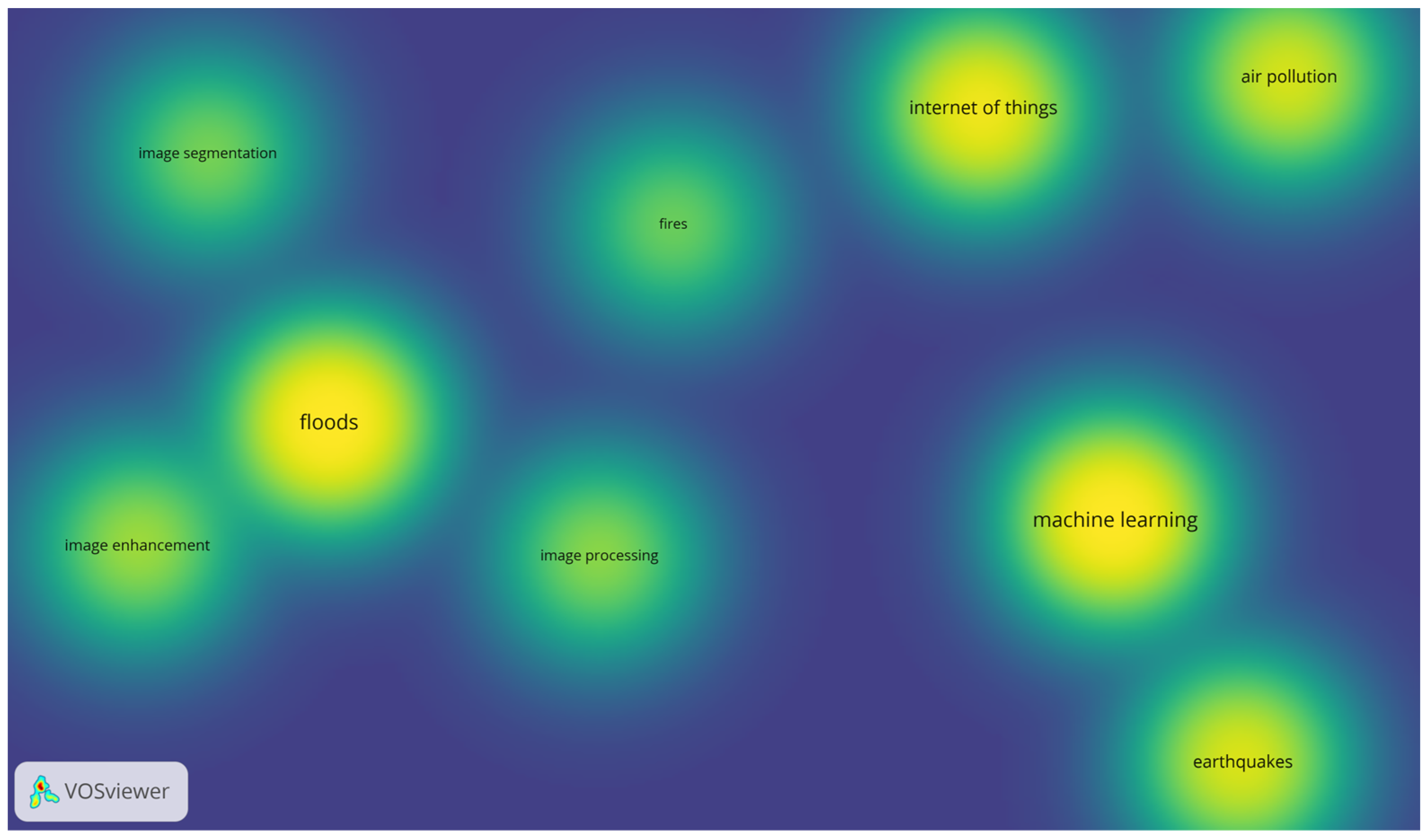



| Keyword | Occurrences | Total Link Strength | Avg. Publication Year |
|---|---|---|---|
| Floods | 42 | 50 | 2020.79 |
| Earthquakes | 26 | 27 | 2021.77 |
| Air Pollution | 25 | 26 | 2020.36 |
| Machine Learning | 24 | 26 | 2020.71 |
| Deep Learning | 33 | 31 | 2022.09 |
| Image Enhancement | 17 | 21 | 2021.00 |
| Image Processing | 15 | 18 | 2019.00 |
| Fires | 12 | 13 | 2022.08 |
| Research Area | Examples of Technology and Methods | Purpose and Use | Examples of Publications |
|---|---|---|---|
| Satellite data and remote sensing | SAR, optical, hyperspectral, multispectral images | Rapid and accurate detection of flooded areas | [3,4,5,6,8,9,10,16,18,20,21,23,24,25,27,28,29,30,32,33,34,35,36,37,38,40,41,45]. |
| IoT integration | Water level sensors, weather stations, environmental measurements | Early warning, real-time monitoring | [7,12,19,30,39,42,44]. |
| ML and AI | CNN, U-Net, HRNet, random forest, SVM | Image segmentation, water level prognosis | [5,6,11,14,17,18,20,28,30,32,36,37,39,41,42]. |
| Hydrological modeling | Hydrodynamic models, Bayesian optimization, hybrid models | Flood risk assessment, hydrological forecasts | [13,16,21]. |
| New indicators and data fusion | NDWI, MNDWI, SOWI, optical radar data fusion | Improving detection and classification accuracy | [8,9,15,29]. |
| Urban and instant mapping | Segmentation of aerial photographs, analysis of built-up areas | Identification of areas difficult to observe | [7,23,28,33,37]. |
| Crowdsourcing and VGI data | Images from drones and smartphones, user data | Satellite data support, rapid flood localization | [14,26]. |
| Specialist applications | Protection of cultural heritage, monitoring of floodplain vegetation | Analysis of the effects of flooding on facilities and the environment | [25,35,43]. |
| Research Area | Examples of Technology/Methods | Purpose/Use | Examples of Publications |
|---|---|---|---|
| Air quality monitoring using IoT and sensor networks | Wireless sensor networks, Arduino/Raspberry Pi microcontrollers, cloud communications | Real-time continuous measurement of air quality, supporting environmental management in cities | [46,51,59,61,66,68,74,77]. |
| Machine learning and artificial intelligence in pollution analysis and forecasting | RF models, LightGBM, CatBoost (Categorical Boosting), YOLO (You Only Look Once), CNN, GAN (Generative Adversarial Network), AQI (Air Quality Index) prediction | Forecasting of pollution levels, high-resolution mapping, identification of emission sources | [47,48,49,53,54,57,60,64,66,67,69,71,77]. |
| Reconstruction and completion of missing data | Graph-based methods, Laplacian interpolation, compressive sampling, data fusion | Improving data quality and consistency in heterogeneous sensor networks | [50,52,55,64,65,73]. |
| Calibration of low-cost sensors and validation of measurements | PM2.5 calibration procedures, ozone, optimization algorithms | Increasing the accuracy of measurements from low-cost equipment | [54,70]. |
| Mobile measurement platforms | Unmanned aerial vehicles, gas sensors, multispectral and thermal imaging cameras | Monitoring of odor and pollutant emissions in hard-to-reach locations | [56,62]. |
| Smart city systems and data integration | Cyber–physical–social systems, smart mirrors | Integrated air quality management, alerting residents, reducing health risks | [63,66,72,74,75,76]. |
| Research Area | Examples of Technology/Methods | Purpose/Use | Examples of Publications |
|---|---|---|---|
| Machine learning and deep learning | CNN, U-Net, ADE-Net2, CubeNet, MagNet, ConvNetQuake, OBSTransformer | Automatic detection, classification, and location of seismic phases | [78,79,80,81,83,84,85,86,88,90,91,92,93,94,95,96,97,99,100]. |
| IoT and distributed systems | Sensor networks, building monitoring, multi-agent systems | Real-time monitoring, integration of various data sources | [19,87,93,101]. |
| Data processing and predictive models | MALMI, wave migration, transfer learning, regression models | Improving the accuracy of location and magnitude estimation | [82,85,86,92,94,97,100]. |
| Ocean bottom seismometers | OBSTransformer, dedicated deep learning models | Detection of P- and S-phases in submarine conditions | [88,92]. |
| Low-energy systems | LoRa, precision sensors | Vibration recording, structural resistance assessment | [87]. |
| Specialized methods and analyses | ULF classifier, iceberg sharing analysis | Early warning, extended applications of seismology | [98,102]. |
| Research Area | Examples of Technology/Methods | Purpose/Use | Examples of Publications |
|---|---|---|---|
| IoT systems and sensors | Arduino, smoke and flame detectors, environmental sensors | Early fire detection, alarm transmission, temperature monitoring | [103,104,106,111,112,113]. |
| Machine learning and deep learning | CNN, YOLO, RCNN, Inception-V3, OFAN | Automatic smoke and fire detection, reduction in false alarms | [104,105,107,108,109,113]. |
| Drones and autonomous systems | Aerial and ground drones with sensors and AI | Real-time fire monitoring and suppression | [109,111]. |
| Satellite systems and risk indices | FDDI, satellite data | Rapid detection and prioritization of fires | [110]. |
| Image segmentation and analysis | Color methods and probability tables | More effective detection of fire outbreaks | [114]. |
| Type of Risk | Key Research Areas | Examples of Technology/Methods | Purpose/Use |
|---|---|---|---|
| Floods | Satellite data and remote sensing; IoT integration; machine learning and AI; hydrological modeling; new indicators and data fusion; urban and rapid mapping; crowdsourcing; specialized applications | SAR, optical, hyperspectral images; water level sensors; CNN, U-Net, HRNet; hydrodynamic models; NDWI, MNDWI, SOWI; data from drones and smartphones | Rapid detection of flooded areas, early warning, risk forecasts, real-time mapping |
| Air Pollutants | IoT networks and sensor systems; machine learning and AI; satellite remote sensing; data fusion; specialized monitoring; new data acquisition methods; systemic and social aspects | Arduino, Raspberry Pi, 5G; RF, CatBoost, LightGBM; Sentinel-5P, Landsat; UAV with gas sensors; electronic ‘noses’; fog analysis | Air quality monitoring, forecasting, data gap reconstruction, emission control, community engagement |
| Earthquakes | Machine learning and AI; distributed measurement systems; IoT integration; multi-source data fusion; microseismicity; early warning systems; automation and the use of open-source solutions | CNN, U-Net, OBSTransformer, CubeNet, MagNet; DAS, OBS, large-N networks; edge and cloud computing; QuakeFlow; Python packages | Real-time detection and location, magnitude estimation, structural monitoring, forecasting |
| Fires | AI-based early detection; IoT and sensor integration; multi-sensor systems; edge computing; data fusion; false alarm reduction; systemic and ethical aspects | CNN, YOLO, RCNN, Inception-V3, OFAN; Arduino; FDDI; satellites; drones; autonomous firefighting robots | Detection of fire outbreaks, rapid alerting, coordination of firefighting operations, minimization of losses |
| Name | 2015–2019 | 2020–2024 | All Years | Share [%] | Chi-Square |
|---|---|---|---|---|---|
| Total | 26 | 86 | 112 | 100.0 | χ2 |
| Document type | |||||
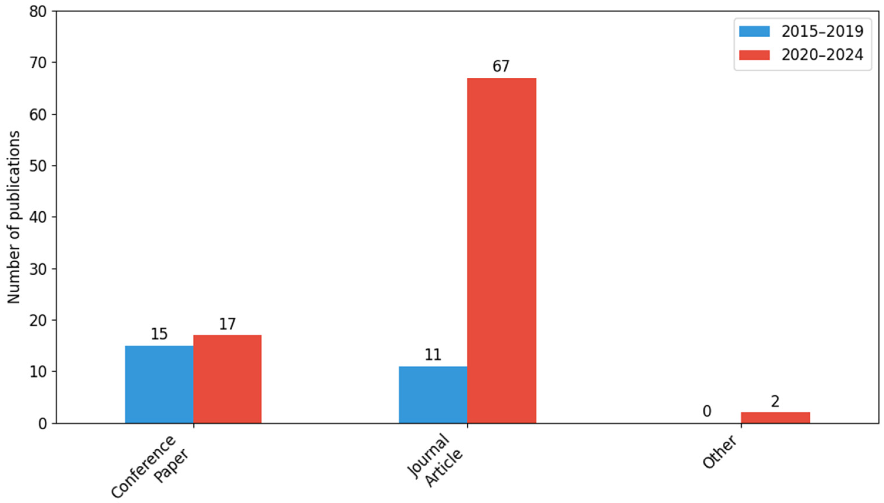
| Conference paper | 15 | 17 | 32 | 28.57 | χ2 = 14.29 (df = 2, p = 0.0) |
| Journal article | 11 | 67 | 78 | 69.64 | |
| Other | 0 | 2 | 2 | 1.79 | |
| Hazard monitoring | |||||
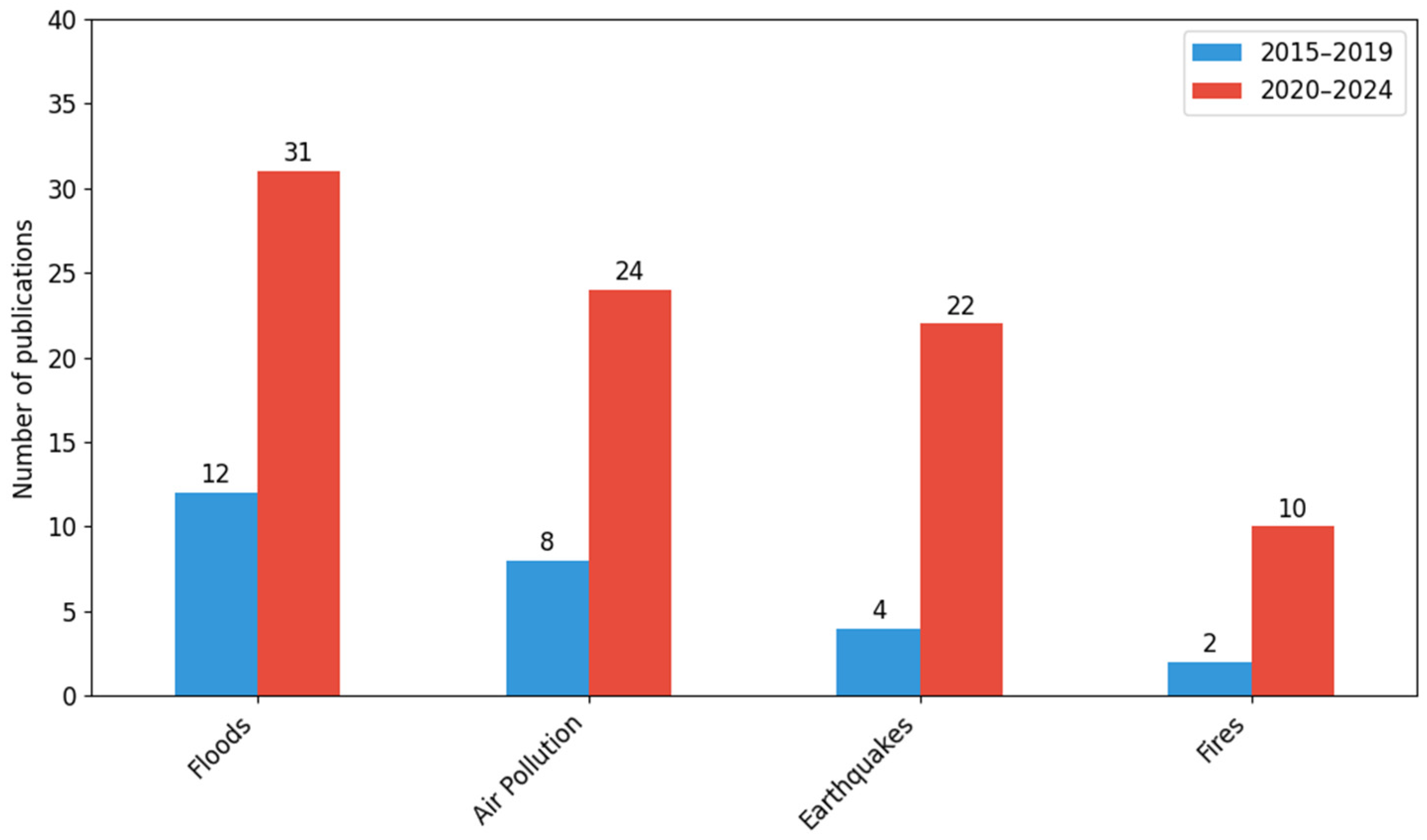
| Floods | 12 | 31 | 43 | 38.39 | χ2 = 1.78 (df = 3, p = 0.62) |
| Air pollution | 8 | 24 | 32 | 28.57 | |
| Earthquakes | 4 | 22 | 26 | 23.21 | |
| Fires | 2 | 10 | 12 | 10.71 | |
| Digital technologies | |||||
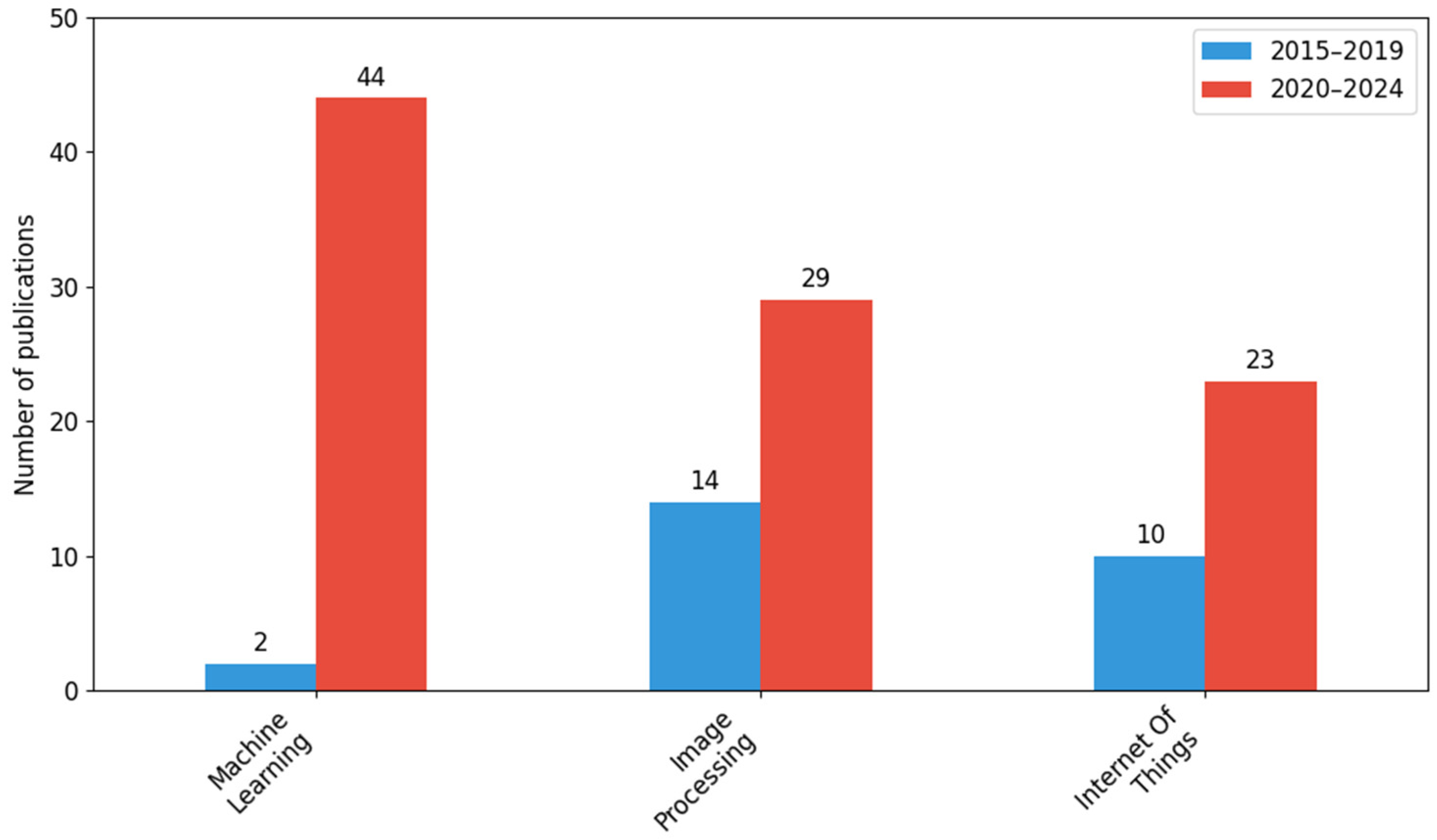
| Machine learning | 2 | 44 | 46 | 41.07 | χ2 = 12.73 (df = 2, p = 0.0) |
| Image processing | 14 | 29 | 43 | 38.39 | |
| Internet of Things | 10 | 23 | 33 | 29.46 | |
| Research methodology | |||||
| Experiment | 14 | 66 | 80 | 71.43 | χ2 = 3.01 (df = 3, p = 0.39) |
| Literature analysis | 5 | 24 | 29 | 25.89 | |
| Case study | 7 | 24 | 31 | 27.68 | |
| Conceptual | 14 | 33 | 47 | 41.96 |
| Country | 2015–2019 | 2020–2024 | All Years | Share [%] | Chi-Square |
|---|---|---|---|---|---|
| All countries | 26 | 86 | 112 | 100.0 | χ2 = 14.11 (df = 11, p = 0.23) |
| China | 4 | 18 | 22 | 19.64 | |
| United States | 2 | 18 | 20 | 17.86 | |
| India | 2 | 16 | 18 | 16.07 | |
| Italy | 2 | 9 | 11 | 9.82 | |
| United Kingdom | 3 | 7 | 10 | 8.93 | |
| South Korea | 1 | 6 | 7 | 6.25 | |
| Germany | 2 | 4 | 6 | 5.36 | |
| Canada | 0 | 5 | 5 | 4.46 | |
| Japan | 0 | 5 | 5 | 4.46 | |
| France | 2 | 2 | 4 | 3.57 | |
| Spain | 1 | 3 | 4 | 3.57 | |
| Other | 7 | 12 | 19 | 16.96 |
| Name | Floods | Air Pollution | Earthquakes | Fires | Total | Chi-Square |
|---|---|---|---|---|---|---|
| Total | 43 | 32 | 26 | 12 | 112 | χ2 |
| Digital technologies | ||||||
| Machine learning | 10 | 13 | 20 | 3 | 46 | χ2 = 60.58 (df = 6, p = 0.0) |
| Image processing | 34 | 2 | 2 | 5 | 43 | |
| Internet of Things | 6 | 18 | 4 | 6 | 33 | |
| Research methodology | ||||||
| Experiment | 31 | 19 | 21 | 9 | 80 | χ2 = 5.81 (df = 9, p = 0.76) |
| Literature analysis | 8 | 10 | 7 | 5 | 29 | |
| Case study | 16 | 6 | 7 | 2 | 31 | |
| Conceptual | 16 | 13 | 13 | 5 | 47 |
Disclaimer/Publisher’s Note: The statements, opinions and data contained in all publications are solely those of the individual author(s) and contributor(s) and not of MDPI and/or the editor(s). MDPI and/or the editor(s) disclaim responsibility for any injury to people or property resulting from any ideas, methods, instructions or products referred to in the content. |
© 2026 by the authors. Licensee MDPI, Basel, Switzerland. This article is an open access article distributed under the terms and conditions of the Creative Commons Attribution (CC BY) license.
Share and Cite
Wilk-Jakubowski, J.L.; Kuchcinski, A.; Wilk-Jakubowski, G.K.; Palej, A.; Pawlik, L. Digital Technologies and Machine Learning in Environmental Hazard Monitoring: A Synthesis of Evidence for Floods, Air Pollution, Earthquakes, and Fires. Sensors 2026, 26, 893. https://doi.org/10.3390/s26030893
Wilk-Jakubowski JL, Kuchcinski A, Wilk-Jakubowski GK, Palej A, Pawlik L. Digital Technologies and Machine Learning in Environmental Hazard Monitoring: A Synthesis of Evidence for Floods, Air Pollution, Earthquakes, and Fires. Sensors. 2026; 26(3):893. https://doi.org/10.3390/s26030893
Chicago/Turabian StyleWilk-Jakubowski, Jacek Lukasz, Artur Kuchcinski, Grzegorz Kazimierz Wilk-Jakubowski, Andrzej Palej, and Lukasz Pawlik. 2026. "Digital Technologies and Machine Learning in Environmental Hazard Monitoring: A Synthesis of Evidence for Floods, Air Pollution, Earthquakes, and Fires" Sensors 26, no. 3: 893. https://doi.org/10.3390/s26030893
APA StyleWilk-Jakubowski, J. L., Kuchcinski, A., Wilk-Jakubowski, G. K., Palej, A., & Pawlik, L. (2026). Digital Technologies and Machine Learning in Environmental Hazard Monitoring: A Synthesis of Evidence for Floods, Air Pollution, Earthquakes, and Fires. Sensors, 26(3), 893. https://doi.org/10.3390/s26030893