Detection of Building Equipment from Mobile Laser Scanning Point Clouds Using Reflection Intensity Correction for Detailed BIM Generation †


Highlights
- Accurate automatic extraction of building equipment using corrected reflectance intensity from MLS point clouds
- Capable of detecting even small and flat objects with almost no omission
- Use of corrected laser intensity is effective for detailed BIM reconstruction from point clouds including building equipment
Abstract
1. Introduction
2. Related Works
2.1. Building Equipment Detection from Point Cloud for Detailed BIM Reconstruction
2.2. Laser Intensity Correction
3. Method
3.1. Overview of the Proposed Method
3.2. Point Sampling
3.3. Intensity Correction
| Algorithm 1. Intensity Correction by Polynomial Fitting |
Input: A set of scattered 2D points , where is the scanning distance and is the raw intensity of each scanned point .
|
3.4. Extraction of Equipment Candidate Points
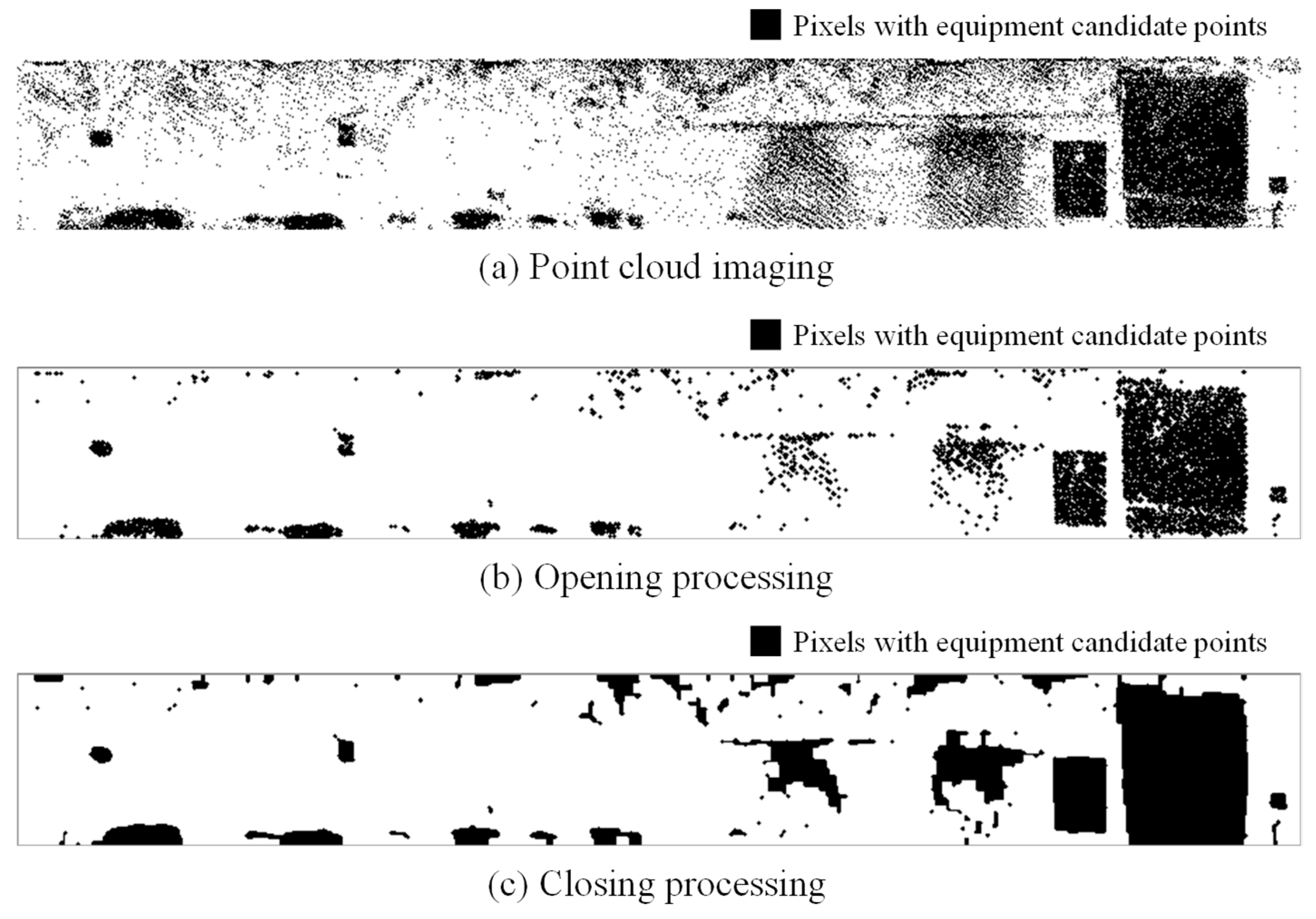
3.5. Imaging of Point Cloud
3.6. Equipment Detection
4. Results and Discussion
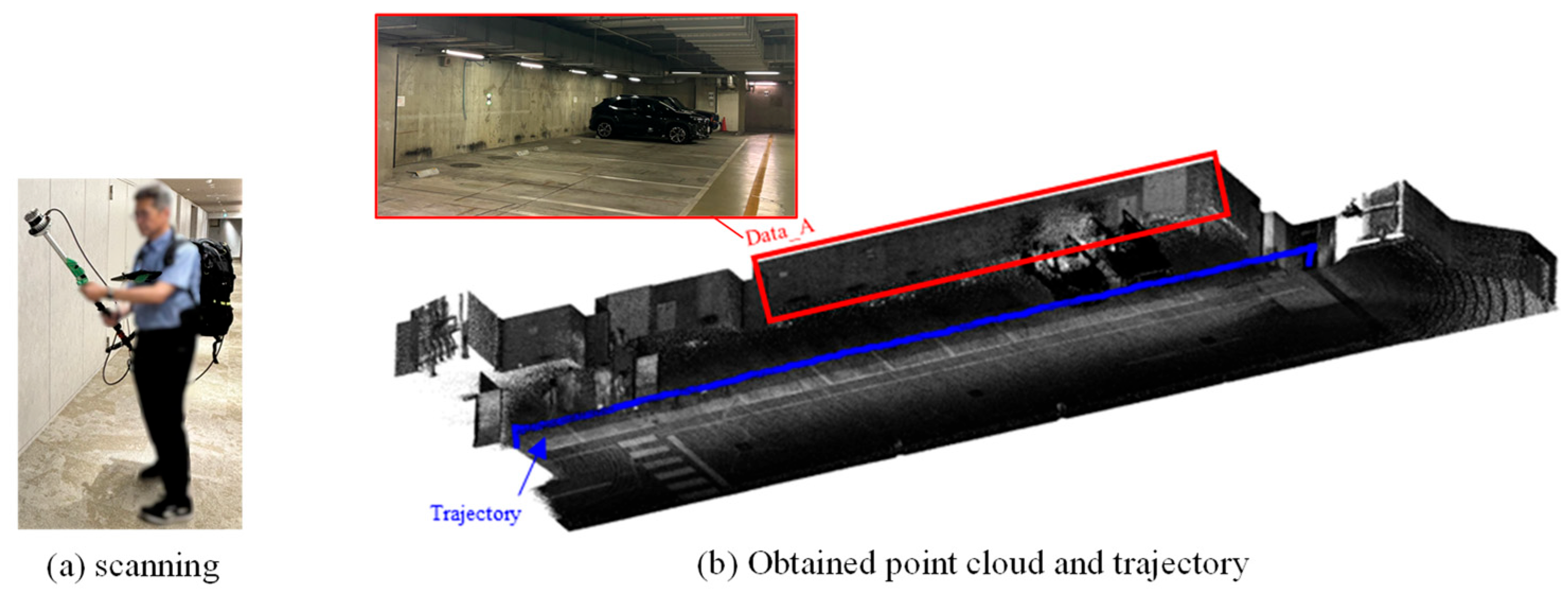
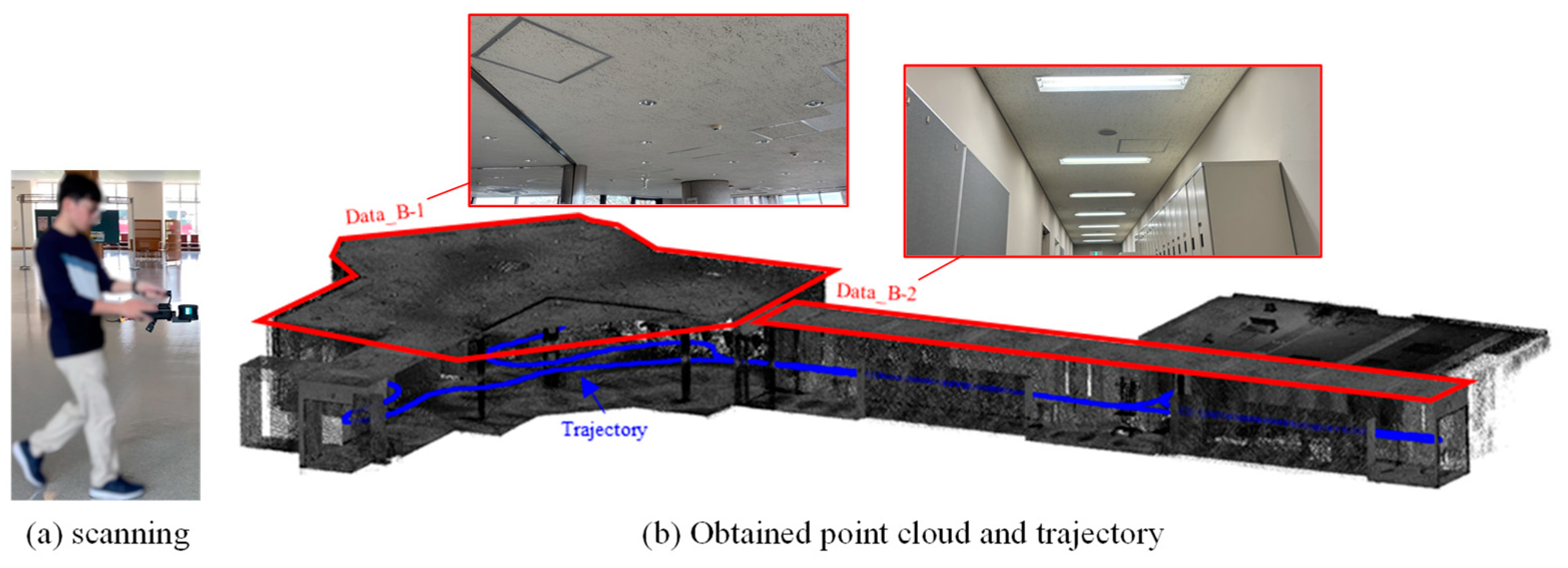
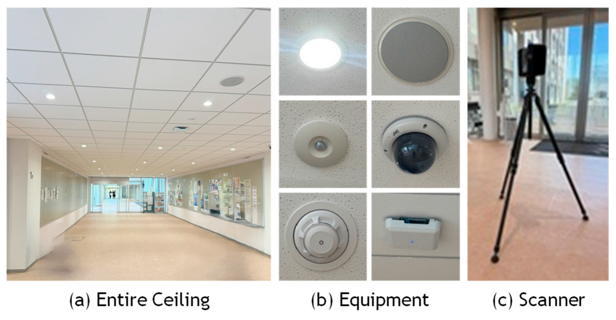
4.1. Test Site and Scanners
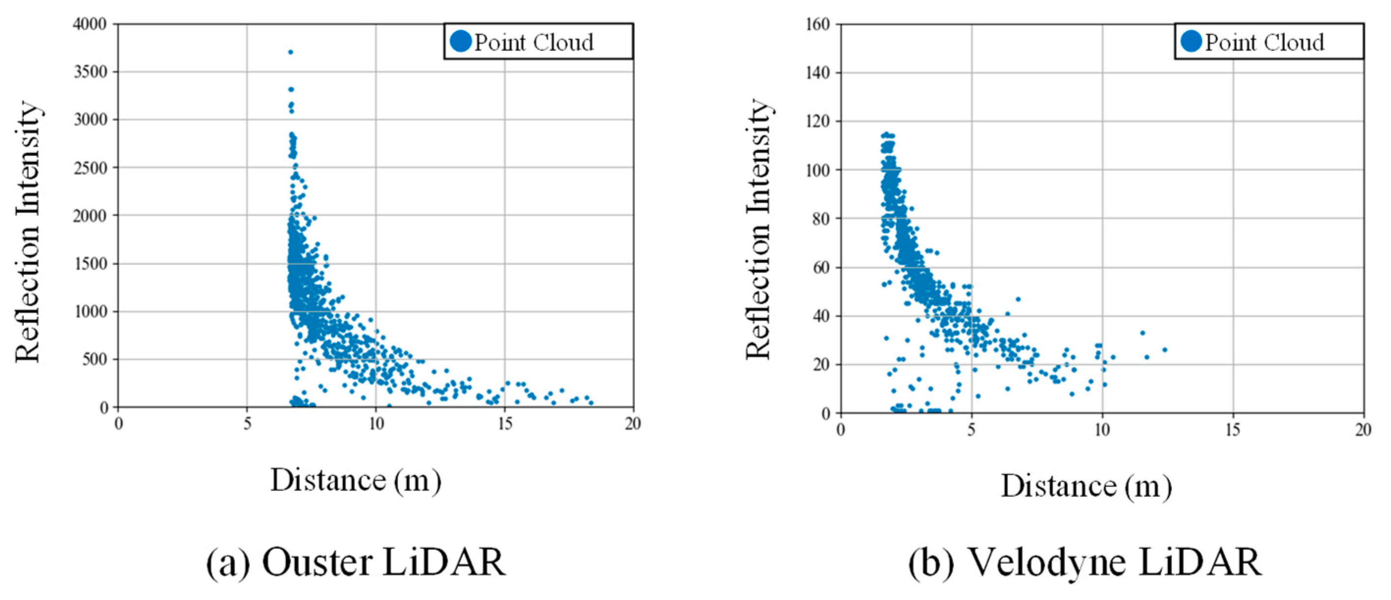
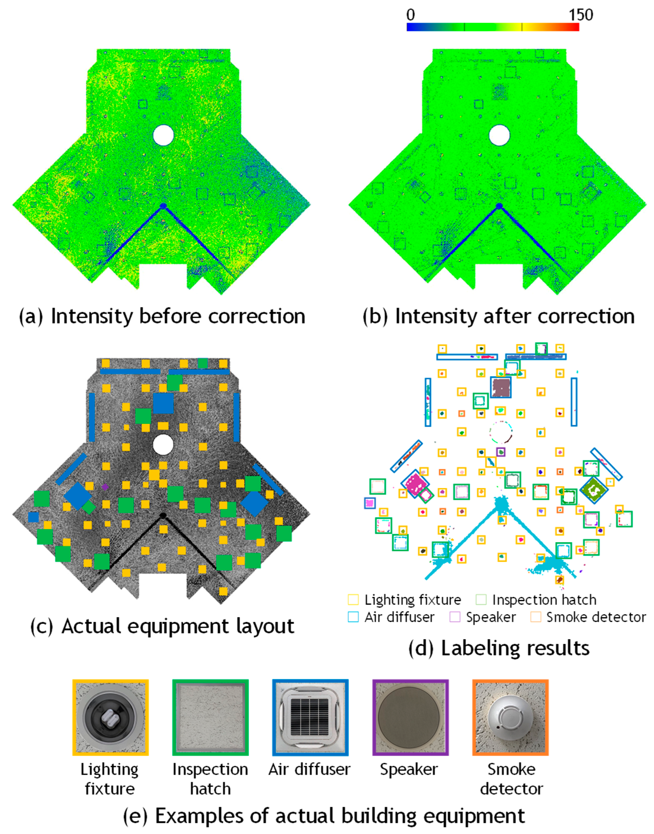
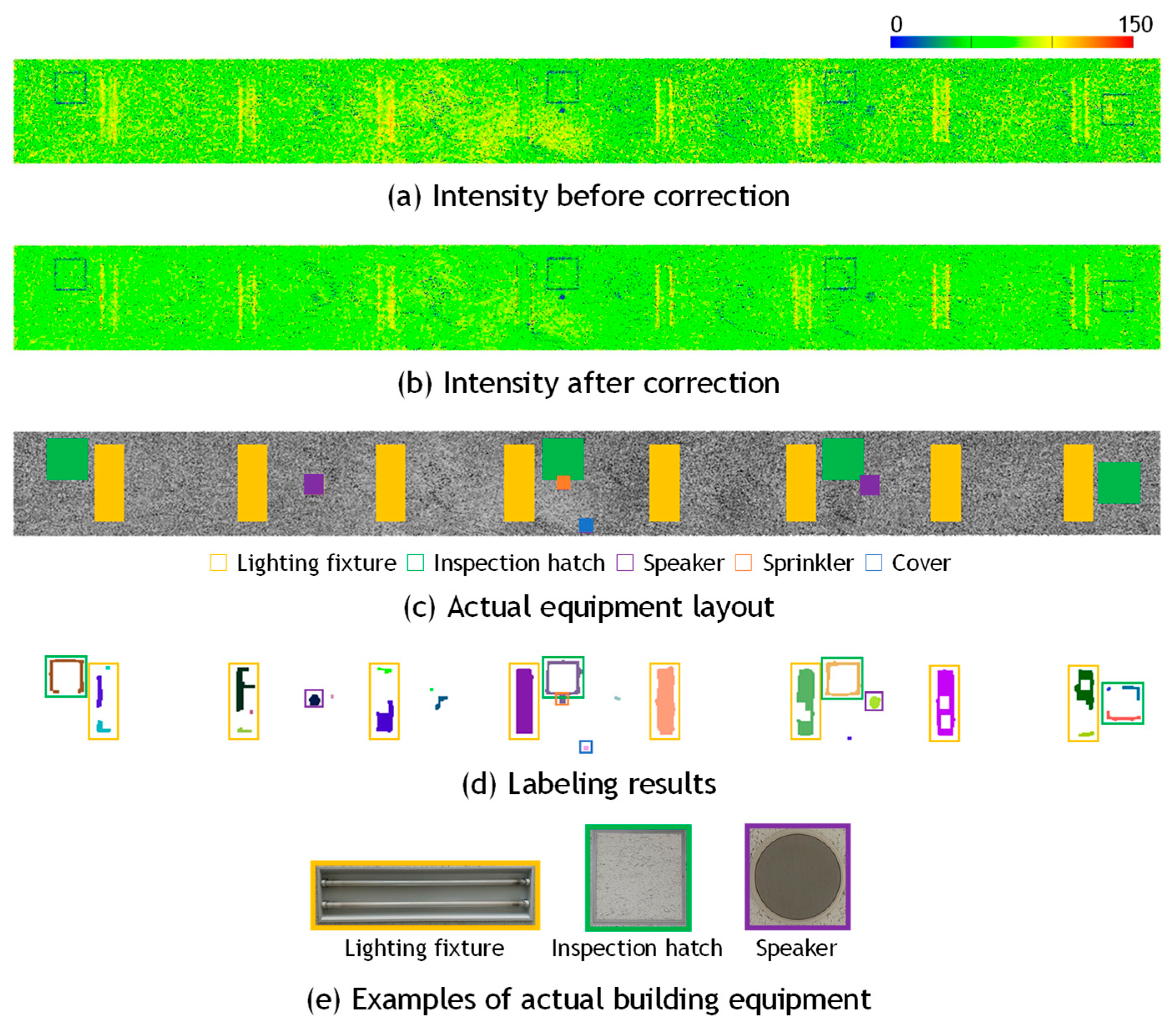
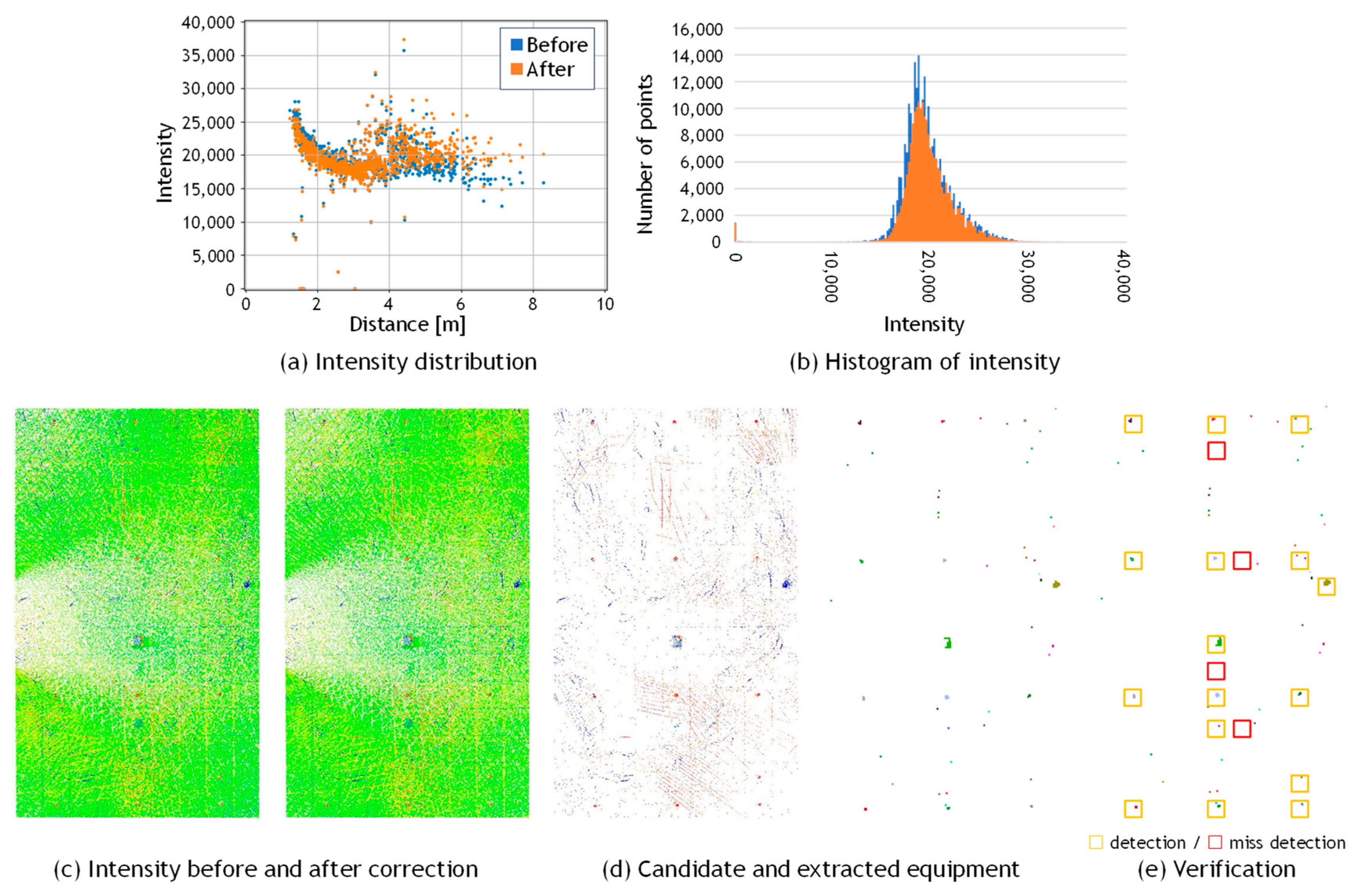
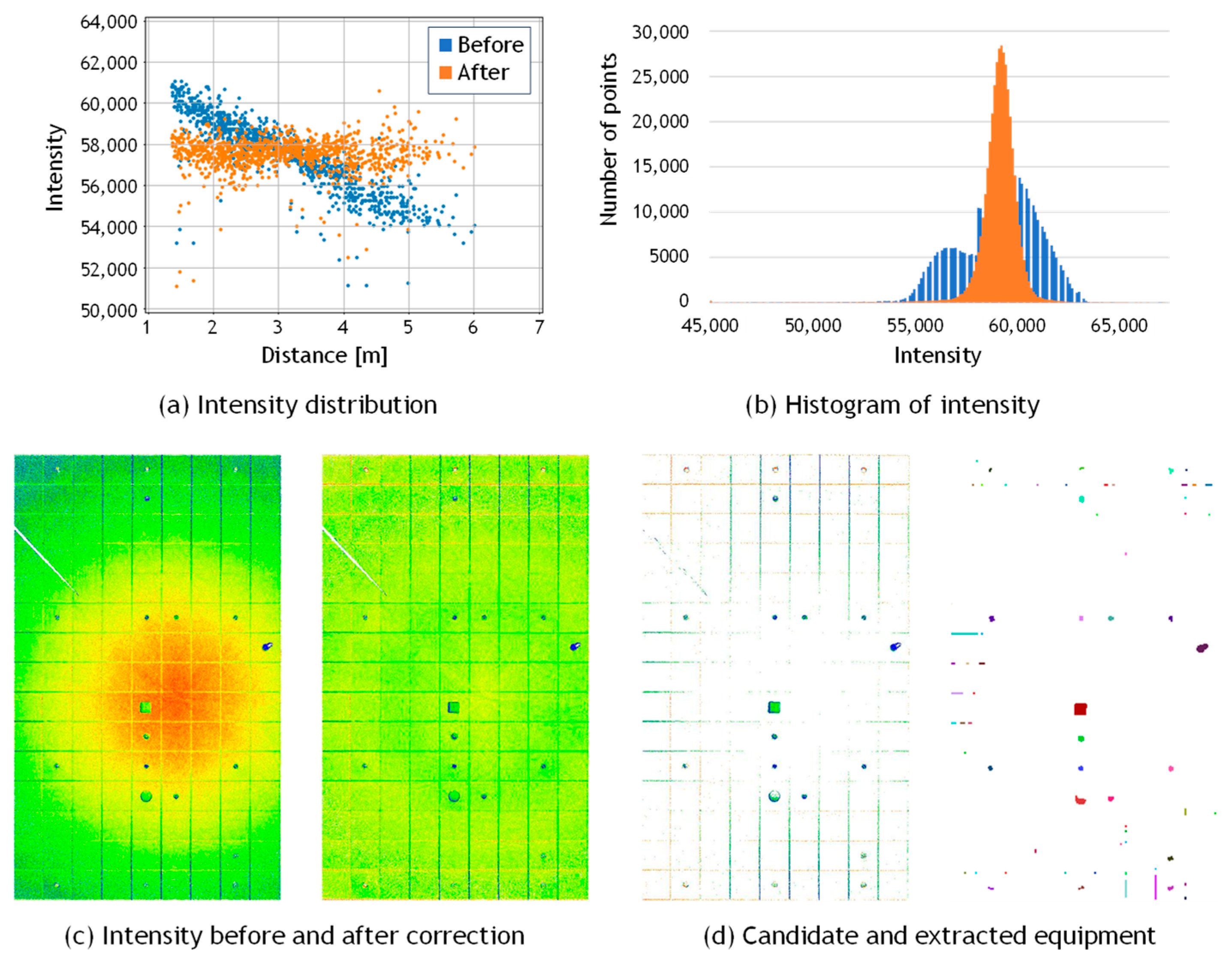
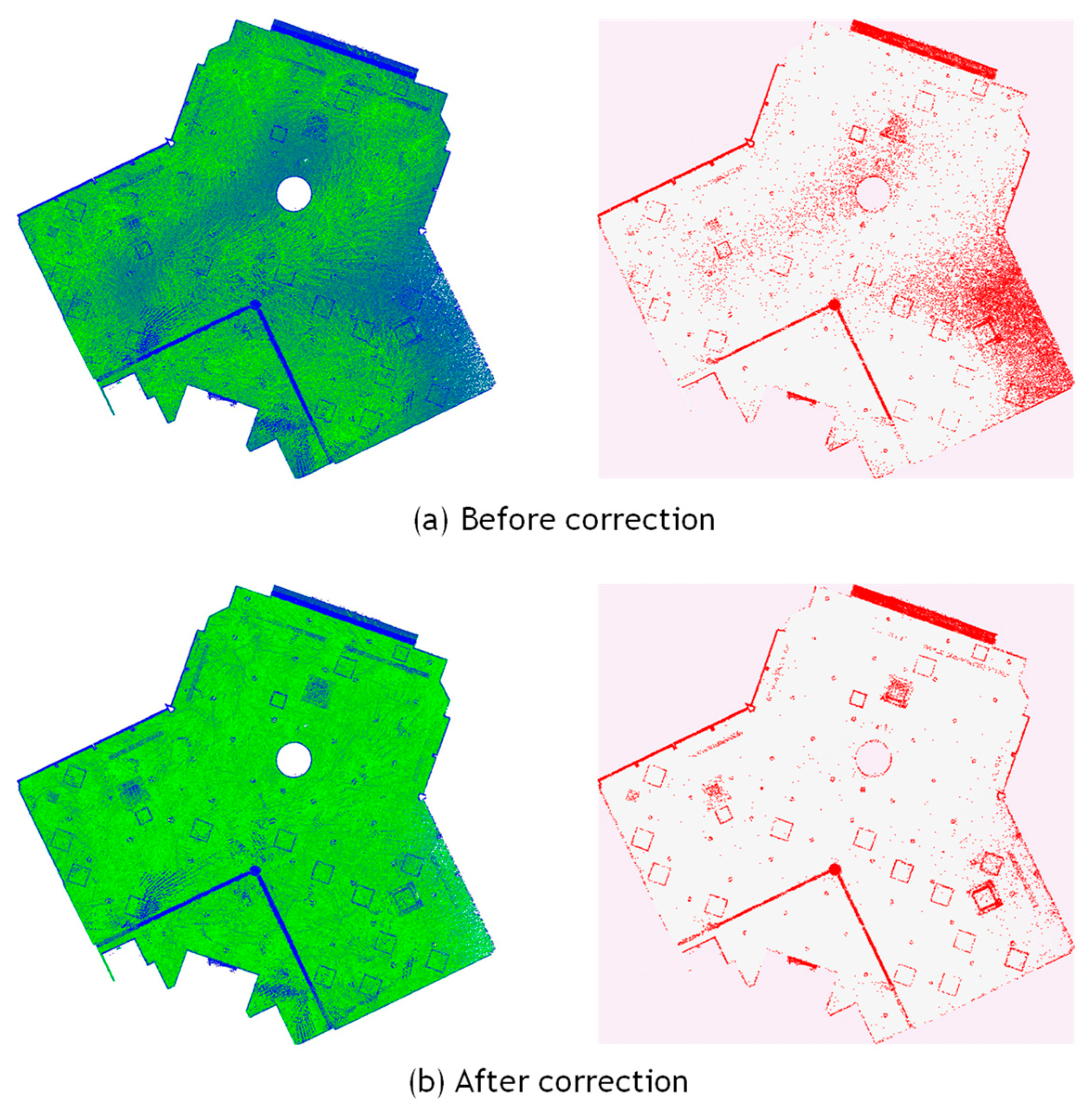
4.2. Results of Intensity Correction
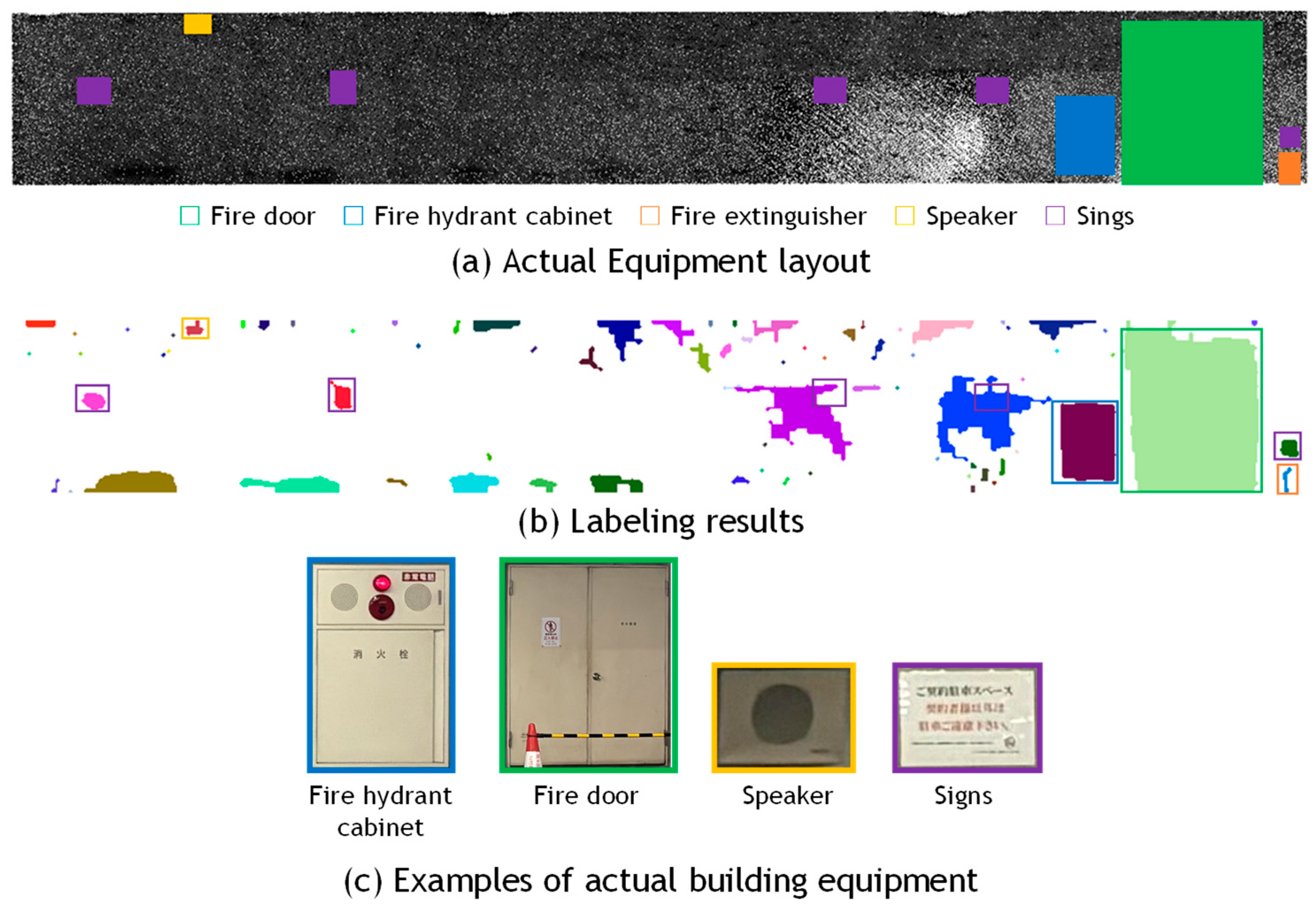
4.3. Results of Equipment Detection
- Number of extracted regions: The total number of clusters consisting of one or more pixels detected in the image, denoted as . The ratio is calculated as (%).
- Correct detection: The number of clusters consisting of one or more pixels that correctly correspond to actual equipment locations, denoted as . When one piece of equipment is divided into multiple regions, all such clusters are counted individually. The ratio is calculated as (%). Note that this is different from the standard metric True Positive (TP).
- Miss detection: The number of actual equipment objects for which no cluster was detected in the image, denoted as . The ratio is calculated as (%). This corresponds to the False Negative (FN).
- Over detection: The number of clusters consisting of one or more pixels that were incorrectly detected in regions where no actual equipment exists, denoted as . The ratio is calculated as (%). This corresponds to the False Positive (FP).
4.4. Verification of General Applicability Using Another MLS and TLS
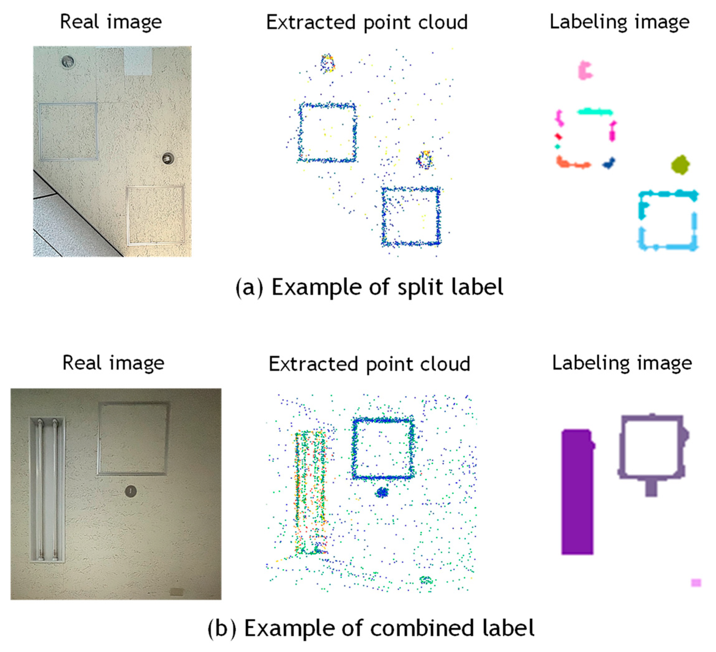
4.5. Discussion
5. Conclusions
Funding
Institutional Review Board Statement
Informed Consent Statement
Data Availability Statement
Acknowledgments
Conflicts of Interest
References
- Kobayashi, A.; Mizoguchi, T. Automatic Detection of Building Equipment using LASER Intensity of MLS Point Cloud. In Proceedings of the Sixth International Conference on Civil and Building Engineering Informatics (ICCBEI 2025), Hong Kong, China, 8–11 January 2025; pp. 250–259. [Google Scholar] [CrossRef]
- Gourguechon, C.; Macher, H.; Landes, T. Automation of As-Built BIM Creation from Point Cloud: An Overview of Research Works Focused on Indoor Environment. In Proceedings of the International Archives of the Photogrammetry and Spatial Information Sciences, Nice, France, 6–11 June 2022. Volume XLⅢ-B2-2022. [Google Scholar] [CrossRef]
- Drobnyi, V.; Hu, Z.; Fathy, Y.; Brilakis, I. Construction and Maintenance of Building Geometric Digital Twins: State of the Art Review. Sensors 2023, 23, 4282. [Google Scholar] [CrossRef] [PubMed]
- Hossain, M.; Ma, T.; Watson, T.; Simmers, B.; Khan, J.A.; Jacobs, E.; Wang, L. Building Indoor Point Cloud Datasets with Object Annotation for Public Safety. In Proceedings of the 10th International Conference on Smart Cities and Green ICT Systems (SMARTGREENS 2021), Online, 28–30 April 2021; pp. 45–56. [Google Scholar] [CrossRef]
- Di Stefano, F.; Chiappini, S.; Gorreja, A.; Balestra, M.; Pierdicca, R. Mobile 3D scan LiDAR: A literature review. Geomat. Nat. Hazards Risk 2021, 12, 2387–2429. [Google Scholar] [CrossRef]
- Mura, C.; Mattausch, O.; Villanueva, A.J.; Gobbetti, E.; Pajarola, R. Automatic room detection and reconstruction in cluttered indoor environments with complex room layouts. Comput. Graph. 2014, 44, 20–32. [Google Scholar] [CrossRef]
- Han, J.; Rong, M.; Jiang, H.; Liu, H.; Shen, S. Vectorized indoor surface reconstruction from 3D point cloud with multistep 2D optimization. ISPRS J. Photogramm. Remote Sens. 2021, 177, 57–74. [Google Scholar] [CrossRef]
- Murali, S.; Speciale, P.; Oswald, M.R.; Pollefeys, M. Indoor Scan2BIM: Building information models of house interiors. In Proceedings of the 2017 IEEE/RSJ International Conference on Intelligent Robots and Systems (IROS), Vancouver, BC, Canada, 24–28 September 2017; pp. 6126–6133. [Google Scholar] [CrossRef]
- Nan, L.; Wonka, P. PolyFit: Polygonal Surface Reconstruction from Point Clouds. In Proceedings of the 2017 IEEE International Conference on Computer Vision (ICCV), Venice, Italy, 22–29 October 2017; pp. 2372–2380. [Google Scholar] [CrossRef]
- Monszpart, A.; Mellado, N.; Brostow, G.J.; Mitra, N.J. Rapter: Rebuilding man-made scenes with regular arrangements of planes. ACM Trans. Graph 2015, 34, 103:1–103:12. [Google Scholar] [CrossRef]
- Hensel SGoebbels, S.; Kada, M. Façade Reconstruction for Textured LOD2 CityGML Models based on Deep Learning and Mixed Integer Linear Programming. ISPRS Ann. Photogramm. Remote Sens. Spat. Inf. Sci. 2019, 4, 37–44. [Google Scholar] [CrossRef]
- Pantoja-Rosero, B.G.; Achanta, R.; Kozinski, M.; Fua, P.; Perez-Cruz, F.; Beyer, K. Generating LOD3 building models from structure-from-motion and semantic segmentation. Autom. Constr. 2022, 141, 104430. [Google Scholar] [CrossRef]
- Pantoja-Rosero, B.G.; Achanta, R.; Beyer, K. Damage-augmented digital twins towards the automated inspection of buildings. Autom. Constr. 2023, 150, 104842. [Google Scholar] [CrossRef]
- Akiyama, R.; Date, H.; Kanai, S.; Yasutake, K. Ceiling Equipment Extraction from TLS Point Clouds for Reflected Ceiling Plan Creation. Int. J. Autom. Technol. 2024, 18, 603–612. [Google Scholar] [CrossRef]
- Trigka, M.; Dritsas, E. A Comprehensive Survey of Deep Learning Approaches in Image Processing. Sensors 2025, 25, 531. [Google Scholar] [CrossRef] [PubMed]
- Griffiths, D.; Boehm, J. A Review on Deep Learning Techniques for 3D Sensed Data Classification. Remote Sens. 2019, 11, 1499. [Google Scholar] [CrossRef]
- Guo, Y.; Wang, H.; Hu, Q.; Liu, H.; Liu, L.; Bennamoun, M. Deep Learning for 3D Point Clouds: A Survey. IEEE Trans. Pattern Anal. Mach. Intell. 2021, 43, 4338–4364. [Google Scholar] [CrossRef] [PubMed]
- Pan, Y.; Braun, A.; Brilakis, I.; Borrmann, A. Enriching geometric digital twins of buildings with small objects by fusing laser scanning and AI-based image recognition. Autom. Constr. 2022, 140, 104375. [Google Scholar] [CrossRef]
- Geyter, S.; Bassier, M.; Winter, H.; Vergauwen, M. Object Detection and Localisation for BIM Enrichment. Int. Arch. Photogramm. Spat. Inf. Sci. 2023, 48, 155–162. [Google Scholar] [CrossRef]
- Anjanappa, G.; Nikoohemat, S.; Oude Elberink, S.; Voûte, R.L.; Lehtola, V.V. Needle in a Haystack: Feasibility of Identifying Small Safety Assets from Point Clouds Using Deep Learning. ISPRS Ann. Photogramm. Remote Sens. Spat. Inf. Sci. 2023, 10, 461–468. [Google Scholar] [CrossRef]
- Li, X.; Shang, Y.; Hua, B.; Yu, R.; He, Y. LiDAR intensity correction for road marking detection. Opt. Lasers Eng. 2023, 160, 107240. [Google Scholar] [CrossRef]
- Li, D.; Liu, T.; Du, P.; He, Y.; Liu, S. Oriented Road Marking Detection in MLS Point Cloud Intensity Images Using Channel and Spatial Attention. IEEE J. Sel. Top. Appl. Earth Obs. Remote Sens. 2025, 18, 12588–12602. [Google Scholar] [CrossRef]
- Naich, A.Y.; Carrión, J.R. LiDAR-Based Intensity-Aware Outdoor 3D Object Detection. Sensors 2024, 24, 2942. [Google Scholar] [CrossRef]
- Macher, H.; Roy, L.; Landes, T. Automation of Windows Detection from Geometric and Radiometric Information of Point Clouds in a Scan-to-BIM Process, International Archives of Photogrammetry. Remote Sens. Spat. Inf. Sci. 2021, 43, 193–200. [Google Scholar] [CrossRef]
- Park, J.; Cho, Y.K. Laser Intensity-assisted Construction Material Classification in Point Cloud Data using Deep Learning. In Computing in Civil Engineering; American Society of Civil Engineers: Reston, VA, USA, 2021. [Google Scholar]
- Pan, S.; Hu, Y.; Ohya, A.; Yorozu, A. LiDAR mapping using point cloud segmentation by intensity calibration for localization in seasonal changing environment. Smart Agric. Technol. 2025, 11, 100970. [Google Scholar] [CrossRef]
- Bai, J.; Niu, Z.; Gao, S.; Bi, K.; Wang, J.; Huang, Y.; Sun, G. An exploration, analysis, and correction of the distance effect on terrestrial hyperspectral LiDAR data. ISPRS J. Photogramm. Remote Sens. 2023, 198, 60–83. [Google Scholar] [CrossRef]
- Kaasalainen, S.; Jaakkola, A.; Kaasalainen, M.; Krooks, A.; Kukko, A. Analysis of Incidence Angle and Distance Effects on Terrestrial Laser Scanner Intensity: Search for Correction Methods. Remote Sens. 2011, 3, 2207–2221. [Google Scholar] [CrossRef]
- Tan, K.; Cheng, X. Intensity data correction based on incidence angle and distance for terrestrial laser scanner. J. Appl. Remote Sens. 2015, 9, 094094. [Google Scholar] [CrossRef]
- Tan, K.; Cheng, X. Distance Effect Correction on TLS Intensity Data Using Naturally Homogeneous Targets. IEEE Geosci. Remote Sens. Lett. 2020, 17, 499–503. [Google Scholar] [CrossRef]
- Liu, X.; Li, Q.; Xu, Y.; Wei, X. Point Cloud Intensity Correction for 2D LiDAR Mobile Laser Scanning; Wireless Communications and Mobile Computing: Shanghai, China, 2022; p. 3707985. [Google Scholar] [CrossRef]
- Bai, J.; Niu, Z.; Wang, L. A theoretical demonstration on the independence of distance and incidence angle effects for small-footprint hyperspectral LiDAR: Basic physical concepts. Remote Sens. Environ. 2024, 315, 114452. [Google Scholar] [CrossRef]
- Jeong, J.; Kim, A. LiDAR Intensity Calibration for Road Marking Extraction. In Proceedings of the 2018 15th International Conference on Ubiquitous Robots (UR), Honolulu, Hawaii, USA, 26–30 June 2018. [Google Scholar] [CrossRef]
- Wan, R.; Huang, Y.; Xie, R.; Ma, P. Combined Lane Mapping Using a Mobile Mapping System. Remote Sens. 2019, 11, 305. [Google Scholar] [CrossRef]
- Press, W.H.; Teukolsky, S.A.; Vetterling, W.T.; Flannery, B.P. Numerical Recipes: The Art of Scientific Computing; Cambridge University Press: Cambridge, UK, 2007. [Google Scholar]
- Viswanath, K.; Jiang, P.; Sujit, P.B.; Saripalli, S. Off-Road LiDAR Intensity Based Semantic Segmentation. In Experimental Robotics; Ang, M.H., Jr., Khatib, O., Eds.; Springer Proceedings in Advanced Robotics; Springer: Cham, Switzerland, 2024; Volume 30. [Google Scholar] [CrossRef]
- Redmon, J.; Divvala, S.; Girshick, R.; Farhadi, A. You Only Look Once: Unified, Real-Time Object Detection. In Proceedings of the 2016 IEEE Conference on Computer Vision and Pattern Recognition (CVPR), Las Vegas, NV, USA, 27–30 June 2016; pp. 779–788. [Google Scholar] [CrossRef]
- Dong, C.; Loy, C.C.; He, K.; Tang, X. Image Super-Resolution Using Deep Convolutional Networks. IEEE Trans. Pattern Anal. Mach. Intell. 2016, 38, 295–307. [Google Scholar] [CrossRef]
- Sun, J.; Cao, W.; Xu, Z.; Ponce, J. Learning a convolutional neural network for non-uniform motion blur removal. In Proceedings of the 2015 IEEE Conference on Computer Vision and Pattern Recognition (CVPR), Boston, MA, USA, 7–12 June 2015; pp. 769–777. [Google Scholar] [CrossRef]
- Wang, M.; Huang, R.; Xie, W.; Ma, Z.; Ma, S. Compression Approaches for LiDAR Point Clouds and Beyond: A Survey. ACM Trans. Multimed. Comput. Commun. 2025, 21, 188. [Google Scholar] [CrossRef]
- Wang, M.; Huang, R.; Liu, Y.; Li, Y.; Xie, W. suLPCC: A Novel LiDAR Point Cloud Compression Framework for Scene Understanding Tasks. IEEE Trans. Ind. Inform. 2025, 21, 3816–3827. [Google Scholar] [CrossRef]



| Instrument | OS0 (Ouster) | VLP-16 (Velodyne) |
|---|---|---|
| Weight | 430 g | 830 g |
| Maximum distance | 75 m (80% reflectivity) 35 m (10% reflectivity) | 100 m |
| Accuracy | ±2.5 cm (Lambert Target) ±5.0 cm (Retroreflective Target) | ±3 cm |
| Field of view | 360° × 90° | 360° × 30° |
| Data acquisition rate | 5.2 M points/second | 0.3 M points/second |
| Data_A | Data_B1 | Data_B2 | Data_C (MLS) | Data_C (TLS) | |
|---|---|---|---|---|---|
| Scanner | Ouster OS0 | Emesent HoverMap | Emesent HoverMap | FARO Orbis | FARO Focus3D |
| Scanning site | Wall of underground parking lot | Ceiling of building | Ceiling of building | Ceiling of building | Ceiling of building |
| Scanning area (m2) | 42.3 | 125.2 | 44.6 | 98.0 | 98.0 |
| Average scanning distance (m) | 8.0 | 3.1 | 2.5 | 3.4 | 3.1 |
| Number of points before/after down sampling (upper/lower row) | 42,561,880 495,598 | 27,356,221 1,286,807 | 27,356,221 588,432 | 100,246,931 517,217 | 43,865,406 393,200 |
| Number of equipment by class | Fire door (1) Fire hydrant cabinet (1) Fire extinguisher (1) Speaker (1) Sign (5) | Lighting fixture (56) Inspection hatch (16) Air diffuser (Square) (3) Air diffuser (Slot) (6) Speaker (1) Smoke detector (5) | Lighting fixture (8) Inspection hatch (4) Speaker (2) Sprinkler (1) Cover (1) | Lighting fixture (12) Sprinkler (2) Air diffuser (3) Speaker (1) Security camera (1) Wi-Fi router (1) | Lighting fixture (12) Sprinkler (2) Air diffuser (3) Speaker (1) Security camera (1) Wi-Fi router (1) |
| Scanner | Target Area | Average | Standard Deviation | |
|---|---|---|---|---|
| Ouster LiDAR | Wall of underground parking (Data_A) | Before | 1101.0 | 605.5 |
| After | 904.9 | 309.3 | ||
| Velodyne LiDAR | Ceiling of elevator hall (Data_B-1) | Before | 66.4 | 27.2 |
| After | 61.9 | 16.6 | ||
| Ceiling of the hallway (Data_B-2) | Before | 78.7 | 22.5 | |
| After | 76.0 | 16.6 | ||
| Data_A | Data_B-1 | Data_B-2 | Data_C (MLS) | Data_C (TLS) | ||||||
|---|---|---|---|---|---|---|---|---|---|---|
| Number of equipment | 9 | - | 87 | - | 16 | - | 20 | - | 20 | - |
| Number of extracted regions | 77 | 855.6% | 172 | 197.7% | 28 | 175.0% | 48 | 240.0% | 67 | 335.0% |
| Correct detection | 9 | 100.0% | 124 | 142.5% | 23 | 143.8% | 18 | 90.0% | 20 | 100.0% |
| Miss detection | 0 | 0.0% | 0 | 0.0% | 0 | 0.0% | 4 | 20.0% | 0 | 0.0% |
| Over detection | 70 | 90.9% | 48 | 27.9% | 5 | 17.9% | 30 | 62.5% | 47 | 70.2% |
Disclaimer/Publisher’s Note: The statements, opinions and data contained in all publications are solely those of the individual author(s) and contributor(s) and not of MDPI and/or the editor(s). MDPI and/or the editor(s) disclaim responsibility for any injury to people or property resulting from any ideas, methods, instructions or products referred to in the content. |
© 2025 by the author. Licensee MDPI, Basel, Switzerland. This article is an open access article distributed under the terms and conditions of the Creative Commons Attribution (CC BY) license (https://creativecommons.org/licenses/by/4.0/).
Share and Cite
Mizoguchi, T. Detection of Building Equipment from Mobile Laser Scanning Point Clouds Using Reflection Intensity Correction for Detailed BIM Generation. Sensors 2025, 25, 6937. https://doi.org/10.3390/s25226937
Mizoguchi T. Detection of Building Equipment from Mobile Laser Scanning Point Clouds Using Reflection Intensity Correction for Detailed BIM Generation. Sensors. 2025; 25(22):6937. https://doi.org/10.3390/s25226937
Chicago/Turabian StyleMizoguchi, Tomohiro. 2025. "Detection of Building Equipment from Mobile Laser Scanning Point Clouds Using Reflection Intensity Correction for Detailed BIM Generation" Sensors 25, no. 22: 6937. https://doi.org/10.3390/s25226937
APA StyleMizoguchi, T. (2025). Detection of Building Equipment from Mobile Laser Scanning Point Clouds Using Reflection Intensity Correction for Detailed BIM Generation. Sensors, 25(22), 6937. https://doi.org/10.3390/s25226937