Machine Learning-Based Air-to-Ground Channel Model Selection Method for UAV Communications Using Digital Surface Model Data
Abstract
1. Introduction
- We build a new topography dataset for five types of terrain that can be used for automatic topography classification problems.
- Using ML, we propose a practical classifier structure that automatically classifies the terrain type of the analysis region.
- A geospatial information processing method that can be used when classifying terrain is presented, and feature values with excellent performance are analyzed.
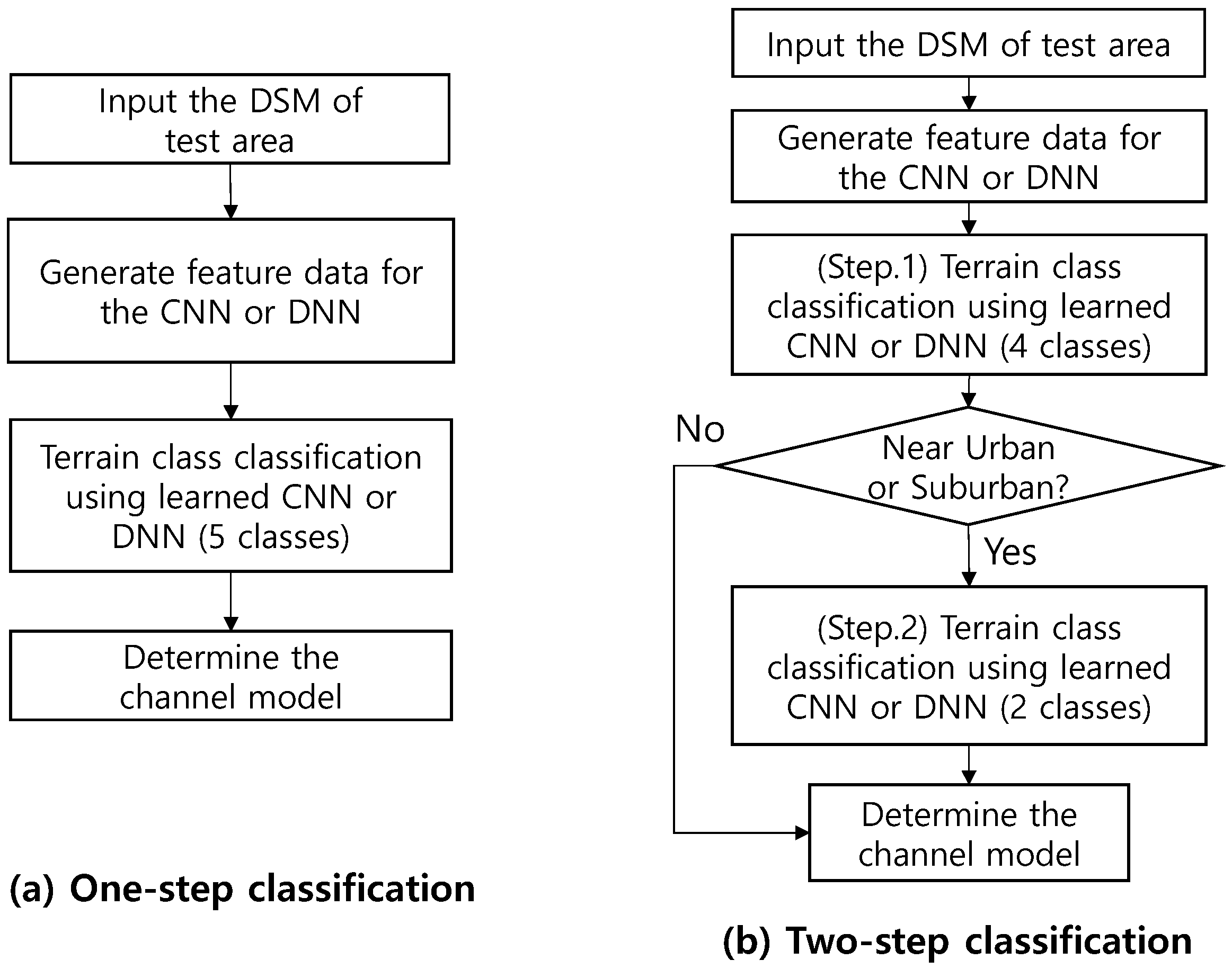
- We propose a two-step NN-based classifier, which can significantly reduce the classification error.
- In conclusion, we propose the first practical automatic terrain type classification method that can be used for the performance evaluation of new communication systems for airspace in a wide range of simulation regions reflecting the actual environment.
2. Background of Research and Construction of New Dataset
2.1. Summary of Existing Research on A2G Channel Models by Terrain
2.2. Building a Dataset for the Topography of South Korea
3. Topographic Feature Extraction Methods for ML Application
3.1. Input Data Processing Methods for Applying DNN
3.2. Input Data Processing Methods for Applying CNN
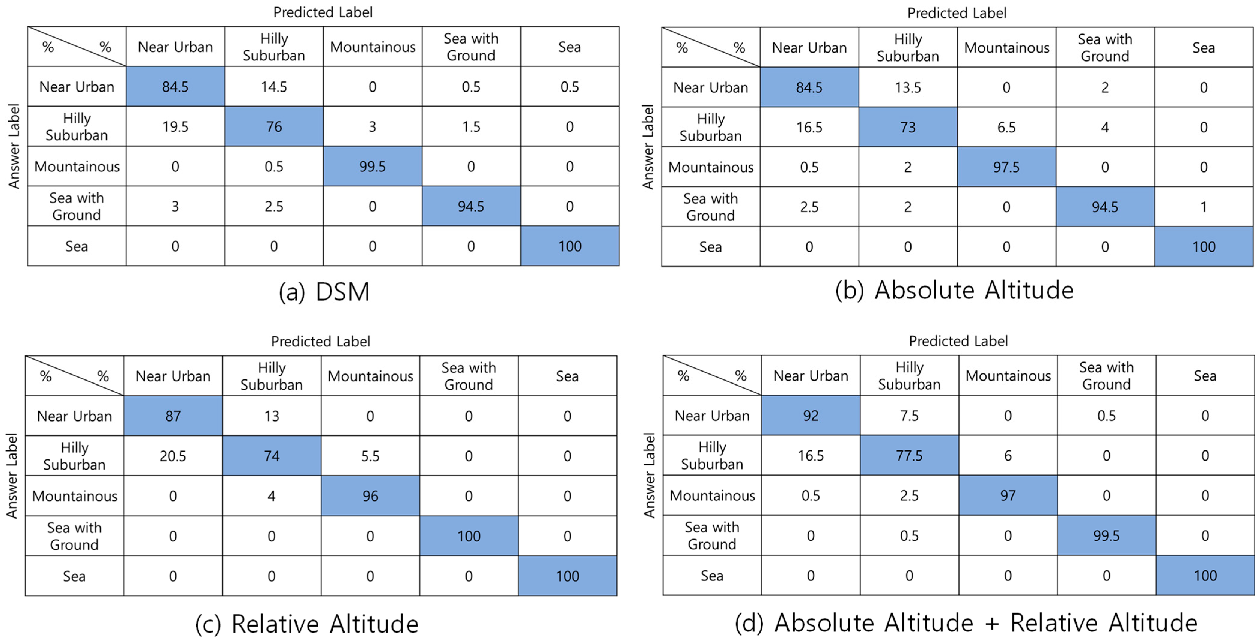
- DSM figure—The first feature is the DSM picture, as shown in Figure 2.
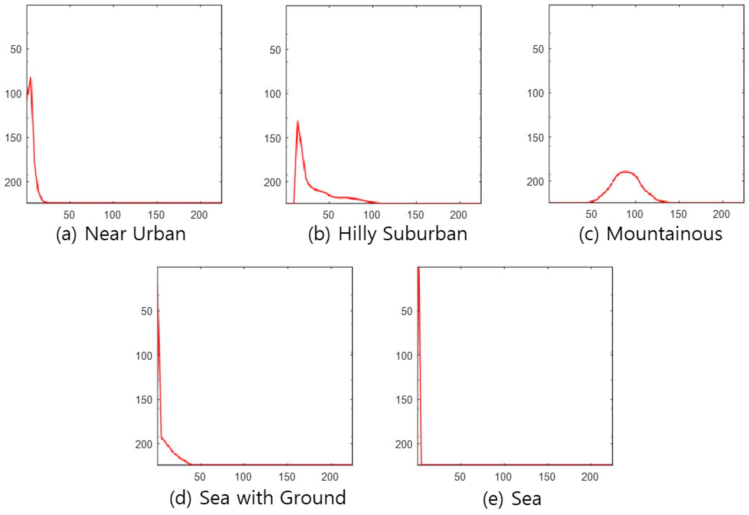
- Absolute-altitude PMF—The second is a graph of the absolute-altitude PMF value used in the DNN, as shown in Figure 3. Near Urban and Hilly Suburban are similar in the picture, and Sea with the Ground and Sea also seem similar.
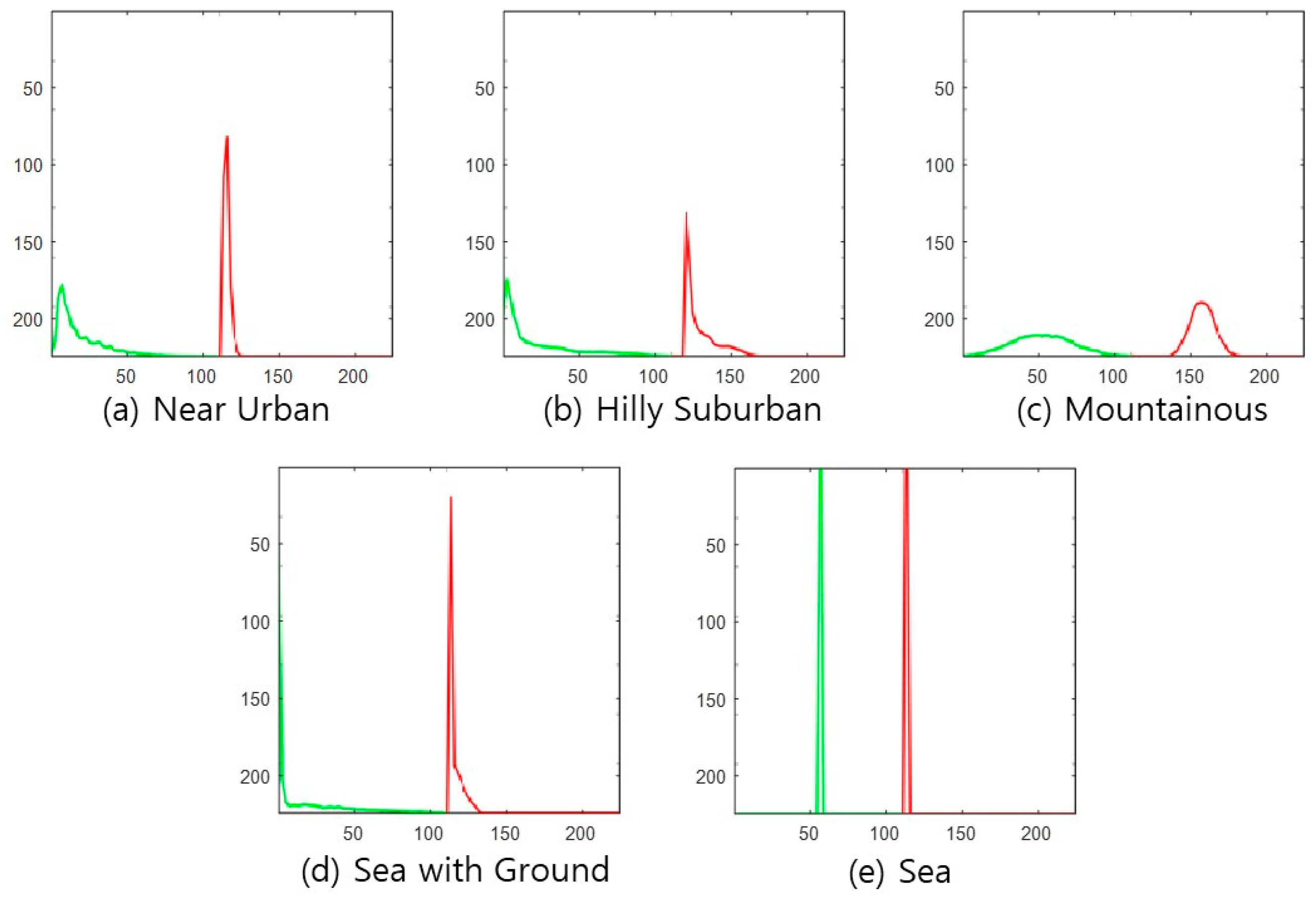
- Relative-altitude PMF—The third is the relative-altitude PMF figure, as shown in Figure 4, and the horizontal axis of each figure represents different altitude values. Compared with the absolute-altitude PMF in Figure 3, the distinction between Sea with the Ground and Sea is clear, whereas the Near Urban and Hilly Suburban cases look almost the same.
- Combination of Absolute and Relative-altitude PMF—Fourth, to consider both the relative-altitude PMF and the absolute-altitude PMF, the two graphs are serially plotted, as shown in Figure 5. When both features are considered together, improvement in accuracy is expected. To distinguish two PMFs, the relative-altitude PMF is indicated in green, and the absolute-altitude PMF is displayed in red.
4. Proposed ML Models
4.1. Structure of the Proposed ML-Based Automatic Topography Class Classifier
4.2. The Structure of DNN and CNN Used for Performance Evaluation
5. Simulation Method and Results
5.1. Simulation Method
5.2. The Performance Evaluation Results of the NN-Based One-Step Classifier
5.2.1. DNN
5.2.2. CNN
5.3. The Performance Evaluation Results of the NN-Based Two-Step Classifier
5.4. Simulations of Existing Methods for Performance Comparison
5.4.1. Conventional Correlation-Based Method
5.4.2. Classified by Human
5.5. Analysis of Experimental Results
6. Conclusions
Author Contributions
Funding
Institutional Review Board Statement
Informed Consent Statement
Data Availability Statement
Conflicts of Interest
References
- International Civil Aviation Organization (ICAO). Unmanned Aircraft Systems Traffic Management (UTM)—A Common Framework with Core Principles for Global Harmonization, 3rd ed.; ICAO: Montreal, QC, Canada, 2020. [Google Scholar]
- Federal Aviation Administration (FAA). Unmanned Aircraft System (UAS) Traffic Management (UTM); Concept of Operation v2.0; FAA: Washington, DC, USA, 2020. [Google Scholar]
- Federal Aviation Administration (FAA). Urban Air Mobility (UAM); Concept of Operations v.1.0.; FAA: Washington, DC, USA, 2020. [Google Scholar]
- UAM Team Korea. K-UAM Concept of Operations 1.0; Ministry of Land, Infrastructure and Transport: Sejong, Republic of Korea, 2021. [Google Scholar]
- Radio Technical Commission for Aeronautics (RTCA). Command and Control (C2) Data Link Minimum Operational Performance Standards (MOPS) (Terrestrial); RTCA Report DO-362 Revision A; RTCA: Washington, DC, USA, 2020. [Google Scholar]
- Lin, X.; Yajnanarayana, V.; Muruganathan, S.D.; Gao, S.; Asplund, H.; Määttänen, H.L.; Bergström, M.; Euler, S.; Wang, Y.E. The Sky Is Not the Limit: LTE for Unmanned Aerial Vehicles. IEEE Commun. Mag. 2018, 56, 204–210. [Google Scholar]
- TR 36.777 v15.0.0; Study on Enhanced LTE Support for Aerial Vehicles (Release 15). The 3rd Generation Partnership Project (3GPP): Valbonne, France, 2017.
- TR 23.755 v17.0.0; Study on Application Layer Support for Unmanned Aerial Systems (UAS). The 3rd Generation Partnership Project (3GPP): Valbonne, France, 2021.
- TR 23.754 v17.0.0; Study on Supporting Unmanned Aerial Systems (UAS) Connectivity, Identification and Tracking (Release 17). The 3rd Generation Partnership Project (3GPP): Valbonne, France, 2021.
- International Telecommunication Union. Terrain Cover Types. Available online: https://www.itu.int/oth/R0A04000031/en (accessed on 1 August 2022).
- Khawaja, W.; Guvenc, I.; Matolak, D.W.; Fiebig, U.C.; Schneckenburger, N. A Survey of Air-to-Ground Propagation Channel Modeling for Unmanned Aerial Vehicles. IEEE Commun. Surv. Tutor. 2019, 21, 2361–2391. [Google Scholar] [CrossRef]
- Meng, Y.S.; Lee, Y.H. Measurements and Characterizations of Air-to-Ground Channel Over Sea Surface at C-Band with Low Airborne Altitudes. IEEE Trans. Veh. Technol. 2011, 60, 1943–1948. [Google Scholar] [CrossRef]
- Leite, D.L.; Alsina, P.J.; de Medeiros Campos, M.M.; de Sousa, V.A., Jr.; de Medeiros, A.A.M. Unmanned Aerial Vehicle Propagation Channel over Vegetation and Lake Areas: First- and Second-Order Statistical Analysis. Sensors 2022, 22, 65. [Google Scholar] [CrossRef] [PubMed]
- Matolak, D.W.; Sun, R. Air-Ground Channel Characterization for Unmanned Aircraft Systems—Part I. Methods, Measurements, and Models for Over-Water Setting. IEEE Trans. Veh. Technol. 2017, 66, 26–44. [Google Scholar] [CrossRef]
- Sun, R.; Matolak, D.W. Air-Ground Channel Characterization for Unmanned Aircraft Systems—Part II: Hilly and mountainous settings. IEEE Trans. Veh. Technol. 2017, 66, 1913–1925. [Google Scholar] [CrossRef]
- Matolak, D.W.; Sun, R. Air-Ground Channel Characterization for Unmanned Aircraft Systems—Part III: The suburban and near urban environments. IEEE Trans. Veh. Technol. 2017, 66, 6607–6618. [Google Scholar] [CrossRef]
- Simunek, M.; Fontán, F.P.; Pechac, P. The UAV Low Elevation Propagation Channel in Urban Areas: Statistical Analysis and Timeseries Generator. IEEE Trans. Antennas Propag. 2013, 61, 3850–3858. [Google Scholar] [CrossRef]
- Amorim, R.; Nguyen, H.; Mogensen, P.; Kovács, I.Z.; Wigard, J.; Sørensen, T.B. Radio Channel Modeling for UAV Communication over Cellular Networks. IEEE Wireless Commun. Lett. 2017, 6, 514–517. [Google Scholar] [CrossRef]
- Li, H.; Chen, X.; Mao, K.; Zhu, Q.; Qiu, Y.; Ye, X.; Zhong, W.; Lin, Z. Air-to-Ground Path Loss Prediction Using Ray Tracing and Measurement Data Jointly Driven DNN. Comput. Commun. 2022, 196, 268–276. [Google Scholar] [CrossRef]
- DEM, DSM & DTM Differences—A Look at Elevation Models in GIS. Available online: https://gisgeography.com/dem-dsm-dtm-differences/ (accessed on 10 August 2022).
- ALOS Global Digital Surface Model “ALOS World 3D—30 m” (AW3D30). Available online: https://www.eorc.jaxa.jp/ALOS/aw3d/index.htm (accessed on 20 September 2022).
- Jung, Y.H.; Kang, Y.; Son, K.; Kim, H.W.; Lim, K. Air-Ground Channel Model Selection Method for UAS Communications Using Digital Elevation Data. In Proceedings of the IEEE 2017 Ninth International Conference on Ubiquitous and Future Networks (ICUFN), Milan, Italy, 4–7 July 2017. [Google Scholar]
- Bithas, P.S.; Michailidis, E.T.; Nomikos, N.; Vouyioukas, D.; Kanatas, A.G. A Survey on Machine-Learning Techniques for UAV-Based Communications. Sensors 2019, 19, 5170. [Google Scholar] [CrossRef] [PubMed]
- Xu, Y.; Sun, Q.; Zhou, W.; Yu, G. Resource allocation for UAV-aided energy harvesting-powered D2D communications: A reinforcement learning-based scheme. Ad Hoc Netw. 2022, 136, 102973. [Google Scholar] [CrossRef]
- Krizhevsky, A.; Sutskever, I.; Hinton, G.E. ImageNet Classification with Deep Convolutional Neural Networks. Adv. Neural Inf. Process. Syst. 2012, 25, 1097–1105. [Google Scholar] [CrossRef]





| Setting | Location | Specific Environment |
|---|---|---|
| Over Sea [14] | Oxnard, CA | Open salt water with few stationary structures & watercraft |
| Urban [16] | Cleveland, OH | Cityscape view with many tall buildings on flat terrain, adjoining open freshwater |
| Hilly Suburban [16] | Latrobe, PA | A mix of rural terrain & urban structures in the valley, viewed from the airport |
| Hilly [15] | Latrobe, PA | Ground station (GS) antenna beam to a mountain ridge w/natural cover. Ridge extends into line-of-sight between UAV & GS |
| Mountainous [15] | Telluride, CO | Very ‘Mountainous’ terrain |
| Hilly [15] | Palmdale, CA | Dry, hilly terrain with natural cover |
| Hilly Suburban [16] | Palmdale, CA | Open, flat desert & agricultural terrain |
| Fresh Water [14] | Cleveland, OH | Open fresh water |
| Suburban [16] | Cleveland, OH | Suburban, some over-water, flat terrain |
| Label | Description |
|---|---|
| Near Urban | Terrain with artificial buildings and skyscrapers |
| Hilly Suburban | Suburban terrain, including hills |
| Mountainous | High-altitude mountainous terrain |
| Sea with the Ground | Terrain including sea with land or small islands |
| Sea | Terrain containing only the sea |
| DNN Parameters | Value |
|---|---|
| Number of input nodes | 100 |
| Number of hidden layers | 3 |
| Number of nodes for the 1st hidden layer | 500 |
| Number of nodes for the 2nd hidden layer | 200 |
| Number of nodes for the 3rd hidden layer | 40 |
| Number of output nodes | 2, 4, 5 |
| Activation function of hidden layers | Sigmoid |
| Activation function of the output layer | Softmax |
| Cost function | Cross Entropy |
| Dropout | 0.2 |
| Training method | Stochastic Gradient Descent (SGD) |
| Parameters for DNN | Value |
|---|---|
| Number of training data | 800 |
| Number of test data | 200 |
| Epoch number | 200 |
| Learning rate | 0.001 |
| Momentum | 0.001 |
| Mini-batch size | 128 |
| Parameters for CNN | Value |
|---|---|
| Number of training data | 800 |
| Number of test data | 200 |
| Maximum number of Epoch | 200 |
| Learning rate | 0.01 |
| Training method | SGDM (Stochastic Gradient Descent with Momentum) |
| Momentum | 0.9 |
| Mini-batch size | 128 |
| NN | DNN | CNN | |
|---|---|---|---|
| Step | |||
| 1st step (4 candidates) | 99.7% | 98.0% | |
| 2nd step (2 candidates) | 83.5% | 87.8% | |
| Classification Method | Classification Accuracy (%) |
|---|---|
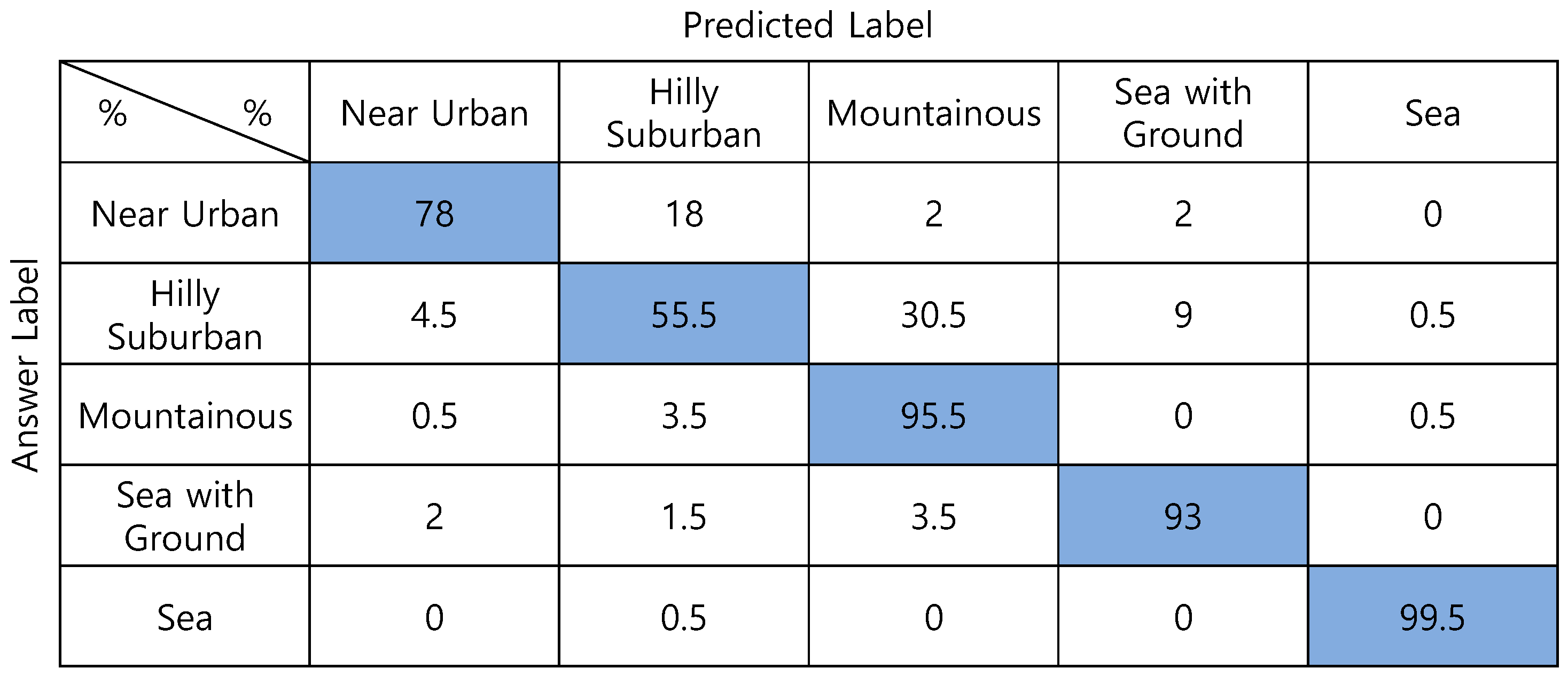
| Two-step NN (proposed) | 95.5 |
| One-step CNN (proposed) | 93.2 |
| One-step DNN (proposed) | 93.0 |
| Cross-correlation [22] | 73.2 |
| Classified by human | 84.3 |
Publisher’s Note: MDPI stays neutral with regard to jurisdictional claims in published maps and institutional affiliations. |
© 2022 by the authors. Licensee MDPI, Basel, Switzerland. This article is an open access article distributed under the terms and conditions of the Creative Commons Attribution (CC BY) license (https://creativecommons.org/licenses/by/4.0/).
Share and Cite
Kang, Y.-E.; Jung, Y.-H. Machine Learning-Based Air-to-Ground Channel Model Selection Method for UAV Communications Using Digital Surface Model Data. Sensors 2022, 22, 9234. https://doi.org/10.3390/s22239234
Kang Y-E, Jung Y-H. Machine Learning-Based Air-to-Ground Channel Model Selection Method for UAV Communications Using Digital Surface Model Data. Sensors. 2022; 22(23):9234. https://doi.org/10.3390/s22239234
Chicago/Turabian StyleKang, Young-Eun, and Young-Ho Jung. 2022. "Machine Learning-Based Air-to-Ground Channel Model Selection Method for UAV Communications Using Digital Surface Model Data" Sensors 22, no. 23: 9234. https://doi.org/10.3390/s22239234
APA StyleKang, Y.-E., & Jung, Y.-H. (2022). Machine Learning-Based Air-to-Ground Channel Model Selection Method for UAV Communications Using Digital Surface Model Data. Sensors, 22(23), 9234. https://doi.org/10.3390/s22239234


