Education in Geosciences

A topical collection in Geosciences (ISSN 2076-3263).

Viewed by 43993

Editor


E-Mail Website
Collection Editor
1.Science Teaching Unit, Department of Geoscience, Environmental and Land Planning, Faculty of Sciences, University of Porto, Porto, Portugal
2.Interdisciplinary Centre of Marine and Environmental Research, University of Porto, Porto, Portugal
Interests: teachers of biology and geology training and professional development; science teaching and communication; environmental education and education for sustainability, science teaching approaches and methodologies; geoethics
Special Issues, Collections and Topics in MDPI journals

Topical Collection Information

Dear Colleagues,

The acceptance that humans must have a holist view of the Earth system and geoethical behaviours is an imperative to live in harmony on Earth.

Life on Earth depends on the responsible and geoethical management that humans need to have with its interworking subsystems. Our efforts have to start with younger children, and involve higher education students, making them aware of what they must do to have a sustainable planet. Citizens must be better informed on issues like resource efficiency, geodiversity and ecosystem services. Teaching this dynamic view of our planet is a way to extend the study of geosciences to all citizens.

Earth system thinking can be taught, resorting to a contextualized teaching, like problem-based learning or case-based learning. Diverse strategies, from lab activities to field-trips, can promote a correct view of science, and raise interest and motivation to learn geosciences. However, more research has to be done to overcome teachers’ resistance to innovation and provoke attitudinal changes.

As the Editor of the collection “Education in Geosciences”, I would like to invite all of you to submit articles which focus on geosciences education for our times, both review articles and empiric ones, and developed in any school level, in higher education or in non-formal educational environments.

Prof. Dr. Clara Vasconcelos
Collection Editor

Manuscript Submission Information

Manuscripts should be submitted online at www.mdpi.com by registering and logging in to this website. Once you are registered, click here to go to the submission form. Manuscripts can be submitted until the deadline. All submissions that pass pre-check are peer-reviewed. Accepted papers will be published continuously in the journal (as soon as accepted) and will be listed together on the collection website. Research articles, review articles as well as short communications are invited. For planned papers, a title and short abstract (about 100 words) can be sent to the Editorial Office for announcement on this website.

Submitted manuscripts should not have been published previously, nor be under consideration for publication elsewhere (except conference proceedings papers). All manuscripts are thoroughly refereed through a single-blind peer-review process. A guide for authors and other relevant information for submission of manuscripts is available on the Instructions for Authors page. Geosciences is an international peer-reviewed open access monthly journal published by MDPI.

Please visit the Instructions for Authors page before submitting a manuscript. The Article Processing Charge (APC) for publication in this open access journal is 1800 CHF (Swiss Francs). Submitted papers should be well formatted and use good English. Authors may use MDPI's English editing service prior to publication or during author revisions.

Keywords

  • Earth system approach
  • Teaching and learning geosciences
  • Geosciences field trips
  • Geosciences lab activities
  • Teaching geoethics
  • Social issues in education in geosciences
  • Geosciences communication and outreach

Published Papers (15 papers)

2024

Jump to: 2023, 2022, 2021, 2020

15 pages, 7578 KiB  
Article
Virtual Mineralogical Museums and Mineral Websites as Learning Agents: Analysis of How Minerals Are Represented
by Guiomar Calvo and Pedro Lucha
Geosciences 2024, 14(9), 235; https://doi.org/10.3390/geosciences14090235 - 1 Sep 2024
Viewed by 1015
Abstract
Virtual mineralogical museums can help visitors construct and enhance their personal scientific mineral models through the information they incorporate. For this to be possible, they must contain a series of key aspects related to minerals’ properties (chemical and physical), use and origin, and [...] Read more.
Virtual mineralogical museums can help visitors construct and enhance their personal scientific mineral models through the information they incorporate. For this to be possible, they must contain a series of key aspects related to minerals’ properties (chemical and physical), use and origin, and the relationships between them. In this study, 38 sites are analyzed, their main characteristics identified, and their educational value assessed, to verify whether all the key aspects considered for the construction of an appropriate and complete mineral model are present. Photographs and mineral files predominate over 3D models and 3D tours. In many of the sites aimed at university students or geoscience experts, there are abundant data about mineral properties, but not in those aimed at a broad public audience. Data about the uses and relationship between uses, extraction, and mineral properties are seldom included. Even if connectivity is very high in all the sites, there are no elements that can be used to test if there has been a knowledge gain after visiting them. The results show that there is still a lot of information missing for this type of resources to be truly helpful for the general population and, specifically, for educational uses. Full article
Show Figures

Figure 1

14 pages, 290 KiB  
Article
The Use of Educational Games to Promote Learning in Geology: Conceptions of Middle and Secondary School Teachers
by Isabel Teixeira and Clara Vasconcelos
Geosciences 2024, 14(1), 16; https://doi.org/10.3390/geosciences14010016 - 4 Jan 2024
Cited by 1 | Viewed by 2744
Abstract
Studies highlight researchers’ concerns about how science should be taught today. It is recognised that teachers have difficulty involving and motivating students to learn about different complex topics, such as geology. Schools must promote skills development to develop citizens who can be active [...] Read more.
Studies highlight researchers’ concerns about how science should be taught today. It is recognised that teachers have difficulty involving and motivating students to learn about different complex topics, such as geology. Schools must promote skills development to develop citizens who can be active and informed in society. One way of undertaking this is to use active methodologies such as educational games, in which students play an essential role in developing activities. Games encourage changes in conceptions regarding the relevance of this scientific topic that is often undervalued by students. Games have gained space in recent years in several disciplines, and it is essential that this tool is thought out and planned within a consistent pedagogical proposal. This educational resource is used to increase motivation for learning, as well as enhance and strengthen the effects of learning. An intervention plan can be framed within game-based teaching. Teachers have been underrepresented in the game-based learning literature, with more emphasis on games’ effects. However, the pedagogical issue of games has been particularly relevant in recent decades. The current investigation used a survey given to geology teachers (n = 112) from public and private middle and secondary schools in Portugal. Its purpose was to assess teachers’ perceptions regarding game-based teaching and its potential to promote active learning. Our sample ages ranged from 24 to 64 years (average of 48.9 years old); 81.3% were women and 18.8% were men. The analysis of the results seems to confirm that although they do not always use games to promote learning in geology, most teachers still recognise their potential to motivate, enhance, and reinforce the learning of geological content, with digital games being the preferred option. They emphasise the importance of teacher training in this area and the inclusion of game applications in school textbooks to approach different geology-related themes. Our results seem to indicate some lack of consistency in teachers’ opinions on the impact of games on student learning. Full article

2023

Jump to: 2024, 2022, 2021, 2020

8 pages, 233 KiB  
Article
Who Wants to Be a Geomorphologist? Gamification in a BSc Teaching Course
by Samuele Segoni
Geosciences 2023, 13(11), 322; https://doi.org/10.3390/geosciences13110322 - 25 Oct 2023
Cited by 1 | Viewed by 1696
Abstract
Despite the importance of Earth sciences in addressing the global challenges that humanity is presently facing, attention toward related disciplines has been witnessed to be globally declining at various levels, including education and university teaching. To increase students’ engagement and explore alternative teaching [...] Read more.
Despite the importance of Earth sciences in addressing the global challenges that humanity is presently facing, attention toward related disciplines has been witnessed to be globally declining at various levels, including education and university teaching. To increase students’ engagement and explore alternative teaching activities, a didactical experiment was carried out at the University of Florence (Italy); the teaching course, “basic elements of geomorphology”, was reorganized to include relevant elements of gamification. Parallel to the frontal lessons, a competition based on a recurring quiz game was conducted. This activity was called “Who wants to be a Geomorphologist?”, clearly paraphrasing a notorious TV show. During every lesson, a moment was included where the students used their mobile devices to access a series of quizzes that were previously prepared by the teacher to test the reasoning skills of the students and their abilities to make connections between distinct topics. A commercial educational app was used to organize the activity, run the quiz sessions, assign points, and update the leaderboard in real time. A quantitative evaluation procedure assessed the positive impacts in terms of supporting the learning process, improving the engagement in the teaching course, and fostering the liking for geomorphology. Full article
16 pages, 5302 KiB  
Article
Teaching Geology in Higher Education Institutions under COVID-19 Conditions
by Georgios Giotopoulos, Dimitrios Papoulis, Ioannis Koukouvelas, Irini Skopeliti, Polychronis Economou and Eleni Gianni
Geosciences 2023, 13(4), 96; https://doi.org/10.3390/geosciences13040096 - 24 Mar 2023
Viewed by 3500
Abstract
Teaching geology under COVID-19 pandemic conditions led to teaching limitations for educators and learning difficulties for students. The lockdown obstructed face-to-face teaching, laboratory work, and fieldtrips. To minimize the impact of this situation, new distance learning teaching methods and tools were developed. The [...] Read more.
Teaching geology under COVID-19 pandemic conditions led to teaching limitations for educators and learning difficulties for students. The lockdown obstructed face-to-face teaching, laboratory work, and fieldtrips. To minimize the impact of this situation, new distance learning teaching methods and tools were developed. The current study presents the results of an empirical study, where distance learning teaching tools were constructed and used to teach geology to university students. A mineralogical mobile phone application was used to replace laboratory mineral identification and a flow chart to replace laboratory rock identification. Additionally, exercises on faults and maps were developed to fill the gap that was created as field work was impossible. A university course on geology was designed on the basis of the constructed distance learning teaching tools, and more than 100 students from the Department of Civil Engineering attended the course. The results show that the proposed tools helped the students to considerably understand scientific information on geology and supported the learning outcomes. Thus, it is suggested that the teaching tools, constructed for the purposes of the study, could be used in conditions when distance learning is required, or even under typical learning conditions after laboratories, as well as before or after fieldtrips, for better learning outcomes. Full article
Show Figures

Figure 1

17 pages, 8812 KiB  
Article
Career in Geology: An Educational Project in Geosciences for the Enhancement of Student Learning in STEM Disciplines
by Filippo Russo and Michele Sisto
Geosciences 2023, 13(2), 50; https://doi.org/10.3390/geosciences13020050 - 6 Feb 2023
Cited by 2 | Viewed by 2043
Abstract
For about 15 years, Italian universities have been experiencing a shortage in the choice of degree programs concerning Earth Sciences, in accordance with the national trend of disaffection to STEM disciplines, both for educational reasons and because of problems in the labor market. [...] Read more.
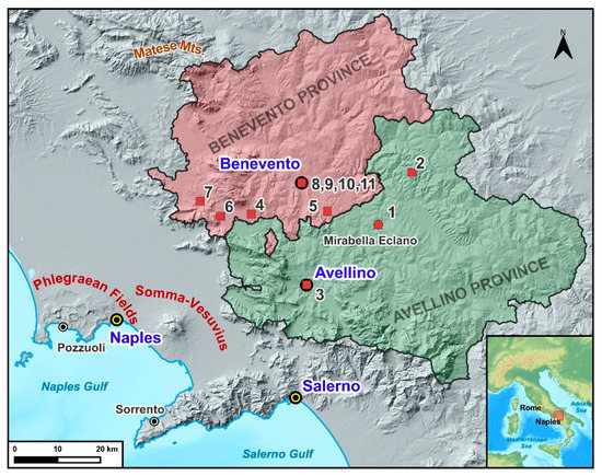
For about 15 years, Italian universities have been experiencing a shortage in the choice of degree programs concerning Earth Sciences, in accordance with the national trend of disaffection to STEM disciplines, both for educational reasons and because of problems in the labor market. To counter this phenomenon, in 2016, the Ministry launched the National Geology Plan (NGP) through which universities interacted directly with educational institutions in their territory. Although the numbers were small, the increase in enrollment was encouraging until the 2018/2019 academic year, before the COVID-19 pandemic. The local project “GEOLAB-UNISANNIO” of the University of Sannio in Benevento is trying to implement an educational program related to STEM fields. The authors believe that either all undergraduates or the public in general would benefit from improved Geoscience education. Accordingly, the authors, as the scientific leaders of an educational program (“Career in Geology”) under the GEOLAB–UNISANNIO project, foresee the positive effects on students’ basic scientific knowledge and academic careers of this type of approach in students’ retaining. This educational program is illustrated in its articulations with the results obtained (field experiences, production of scientific reports and posters, documentaries, general satisfaction). Full article
Show Figures

Figure 1

2022

Jump to: 2024, 2023, 2021, 2020

22 pages, 4127 KiB  
Article
Using EM Induction and ERI Geophysical Methods in Undergraduate Teaching: A Case-Centered, Discussion-Based Approach
by Nuno M. S. Alte-da-Veiga, Luis Fernando Sánchez-Sastre, Jesús Martín-Gil, Salvador Hernández-Navarro and Pablo Martín-Ramos
Geosciences 2022, 12(12), 444; https://doi.org/10.3390/geosciences12120444 - 2 Dec 2022
Viewed by 2271
Abstract
In the last decades, the application fields of exploration geophysics have considerably broadened, reinforcing the relevance of exploration geophysics courses both within geosciences and non-geosciences degrees. Among these courses, those with a hands-on, place-based pedagogical approach and aligned with problem-based and case-based learning [...] Read more.
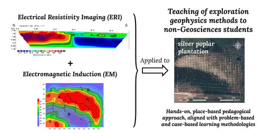
In the last decades, the application fields of exploration geophysics have considerably broadened, reinforcing the relevance of exploration geophysics courses both within geosciences and non-geosciences degrees. Among these courses, those with a hands-on, place-based pedagogical approach and aligned with problem-based and case-based learning methodologies have proven to be particularly successful in regard to addressing the recognized difficulty that students experience in transferring their classroom knowledge to the field environment. In this article, we report a theoretical–practical module for the teaching of exploration geophysics methods to undergraduate non-geoscience major students, and in particular, to forestry engineering students. The in-field activity, based on a combination of Electrical Resistivity Imaging (ERI) and electromagnetic induction (EM) methods, was complemented with in-class sessions covering the fundamentals of these methods and Archie’s equation, software usage, data analysis and interpretation, and critical in-group discussions. This situated, context-rich teaching and learning example may be reproduced in other teaching institutions to provide technology-driven educational experiences in their curricula, helping students recognize the relevance of the abovementioned geophysical methods to address research questions beyond geology. Full article
Show Figures

Graphical abstract

13 pages, 60590 KiB  
Article
GIS-Based Virtual Field Trip as a Tool for Remote Education
by Niki Evelpidou, Anna Karkani, Apostolia Komi, Aikaterini Giannikopoulou, Maria Tzouxanioti, Giannis Saitis, Evangelos Spyrou and Maria-Anna Gatou
Geosciences 2022, 12(9), 327; https://doi.org/10.3390/geosciences12090327 - 30 Aug 2022
Cited by 7 | Viewed by 2685
Abstract
Geoscience courses, such as geology and geomorphology, require not only classroom lessons and laboratory exercises, but field trips as well. However, the COVID-19 restrictions did not allow the execution of most planned field trips, and an alternative needed to be developed. The use [...] Read more.
Geoscience courses, such as geology and geomorphology, require not only classroom lessons and laboratory exercises, but field trips as well. However, the COVID-19 restrictions did not allow the execution of most planned field trips, and an alternative needed to be developed. The use of virtual field trips is one such alternative. Through this research, we evaluate the usefulness of virtual field trips as tools for preparatory activities before an actual field trip takes place in the same area, and their contribution in providing a better understanding of geomorphological processes and landscape evolution. We performed a virtual navigation on the island of Naxos, Cyclades (Aegean Sea, Greece) for a series of virtual field trips, which took place during webinars in the framework of Erasmus+ CIVIS. The virtual field trip was also presented to the third-year students of the Faculty of Geology and Geoenvironment, National and Kapodistrian University of Athens, in the framework of the obligatory course of Geomorphology. Upon completion, all participating students were asked to fill in a questionnaire in order to evaluate the contribution of virtual field trips to their education regarding geomorphology and state their opinion as to whether they can supplement and/or substitute actual field trips. According to the results, virtual field trips can aid, but not substitute, the actual field trip. Most students mentioned that they would attend another virtual field trip in the future, both as an alternative to classroom lessons and as a means of preparation for an actual field trip, but not in order replace the actual one. Virtual field trips can significantly support the realization of actual ones, by introducing the necessary tectonic, geological and geomorphological background of a particular study area and offering more time for practical activities or field methodologies during the actual field trip. Full article
Show Figures

Figure 1

16 pages, 13954 KiB  
Article
Google Earth Geoscience Video Library (GEGVL): Organizing Geoscience Videos in a Google Earth Environment to Support Fieldwork Teaching Methodology in Earth Science
by Ning Wang, Robert J. Stern, Mary L. Urquhart and Katherine M. Seals
Geosciences 2022, 12(6), 250; https://doi.org/10.3390/geosciences12060250 - 15 Jun 2022
Cited by 5 | Viewed by 3319
Abstract
Fieldwork teaching methodology (FTM) and active learning are effective strategies for geoscience education. However, traditional field trips require significant resources, time, physical abilities, and the expertise of teachers. In this study, we provide a supplementary virtual field trip experience by showing how different [...] Read more.
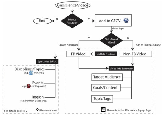
Fieldwork teaching methodology (FTM) and active learning are effective strategies for geoscience education. However, traditional field trips require significant resources, time, physical abilities, and the expertise of teachers. In this study, we provide a supplementary virtual field trip experience by showing how different kinds of geoscience videos can be spatially organized into one digital interactive virtual environment. Here, we present the Google Earth Geoscience Video Library (GEGVL) which uses Google Earth and location-specific videos about Earth events, to create a virtual field-based learning experience. Using Google Earth, GEGVL organizes field-based videos by location and links pertinent non-field-based videos, and allows users to roam the globe in search of geoscientific videos that are pertinent to them or their students. Currently, GEGVL contains 150 videos organized into ten different geoscience disciplines: Plate Tectonics, Minerals, Structural Geology, Metamorphism, Magmatism, Hydrology, Environmental Science, Sedimentology, Paleontology, and Paleomagnetism. Despite stability challenges with Google Earth integration, results of user surveys among lower-division undergraduates show that the design logic of GEGVL is a promising virtual field-based learning organizer for increasing students’ interest in and helping them learn about Earth sciences. Full article
Show Figures

Figure 1

24 pages, 2951 KiB  
Article
Transmedia in Geosciences Education
by Elisabete Peixoto, Luís Pedro and Rui Vieira
Geosciences 2022, 12(4), 171; https://doi.org/10.3390/geosciences12040171 - 13 Apr 2022
Cited by 1 | Viewed by 2765
Abstract
This paper describes a research study related to the development (conception, production, implementation and evaluation) of a set of transmedia activities associated with the study of humans ‘use of rocks. To do so, a narrative was created to guide students through a set [...] Read more.
This paper describes a research study related to the development (conception, production, implementation and evaluation) of a set of transmedia activities associated with the study of humans ‘use of rocks. To do so, a narrative was created to guide students through a set of tasks—namely, during and after a field trip. During this field trip, students had to macroscopically identify a rock sample and record its geographical location, as well as take pictures in six stations. According to the data collected, students would, after the field trip, share this knowledge in a digital learning environment and collect pieces of a puzzle and, in some cases, badges. These transmedia activities, in line with the STS (Science-Technology-Society) perspective, aimed at contributing to the diversification of educational resources for Geosciences education. The study, predominantly qualitative in nature, reached 104 students from the 7th and 5th grades in a Natural Sciences course and the analysis of data suggests that students showed some skills in areas such as “interpersonal relationships”, “scientific, technical, and technological knowledge” and “information and communication”, although in this case they can be considered rather limited. Full article
Show Figures

Figure 1

15 pages, 1374 KiB  
Article
Educational Resources for Geoethical Aspects of Water Management
by Sebastian Handl, Cristina S. C. Calheiros, Markus Fiebig and Guenter Langergraber
Geosciences 2022, 12(2), 80; https://doi.org/10.3390/geosciences12020080 - 8 Feb 2022
Cited by 6 | Viewed by 2871
Abstract
Global water resources are a critical value for the future of humankind. Conflicts and wars seem to rise because of such critical resources. While water-scarce countries are under extreme pressure on the long-term scale, also water-rich countries in Europe, such as Austria, face [...] Read more.
Global water resources are a critical value for the future of humankind. Conflicts and wars seem to rise because of such critical resources. While water-scarce countries are under extreme pressure on the long-term scale, also water-rich countries in Europe, such as Austria, face local conflicts of interest between water supply, tourism, agriculture, hydropower and ecology, for instance. Higher Education must address these conflicts and the new concepts of geoethics offer the conceptional thinking to do so. Based on educational resources for Higher Education that have been developed in the field of “Geoethics and Water Management” under the Erasmus+ co-funded project GOAL (Geoethics Outcomes and Awareness Learning), selected water-related conflicts are discussed. The cases selected for developing the educational resources are water use conflicts and geoethical aspects of hydropower plants. The educational resources include a subsequent procedure for applying them with students. Outcomes from the educational resources show that issues related to water management often create geoethical conflicts and dilemmas, and an interconnection between several Sustainable Development Goals can be established. Applying the educational resources shall enable geoscientists to contribute towards sustainable development of Earth’s future by a more holistic view. Full article
Show Figures

Figure 1

2021

Jump to: 2024, 2023, 2022, 2020

13 pages, 555 KiB  
Review
Educating for a Holistic View of the Earth System: A Review
by Tiago Ribeiro and Nir Orion
Geosciences 2021, 11(12), 485; https://doi.org/10.3390/geosciences11120485 - 24 Nov 2021
Cited by 8 | Viewed by 4664
Abstract
The global society of today struggles with grand challenges, such as climate change, the degradation of ecosystems, and the loss of bio- and geodiversity, as identified in several documents. The search for solutions to these and other problems on the way to sustainable [...] Read more.
The global society of today struggles with grand challenges, such as climate change, the degradation of ecosystems, and the loss of bio- and geodiversity, as identified in several documents. The search for solutions to these and other problems on the way to sustainable development necessarily involves a better understanding of the Earth system and its dynamics. The Earth system is composed of five highly dependent and interrelated subsystems that exchange matter and energy. This notion is at the base of what in the literature is named Earth System Science (ESS). Humanity has been profoundly altering the dynamics of this system, leading to the proposal of a new geological epoch—the Anthropocene. Developing a holistic understanding of the complex and tangled relationships between subsystems and the role of human impacts is the target of study of Earth System Education (ESE). With the assumptions of ESS, ESE is emerging as a new approach in science education. Based on a deep knowledge of the planet and the development of specific competencies, such as system thinking, it is possible to perform more actively and consciously in the relationships that citizens develop with the Earth system, enabling the existence of a more viable future for humanity. Full article
Show Figures

Figure 1

11 pages, 709 KiB  
Communication
Geoethics in the Scenario of the Geological Society in Brazil
by Rosely Aparecida Liguori Imbernon, Paulo de Tarso Amorim Castro and Kátia Leite Mansur
Geosciences 2021, 11(11), 462; https://doi.org/10.3390/geosciences11110462 - 9 Nov 2021
Cited by 3 | Viewed by 2145
Abstract
The development model assumed by human society over the last century is opposed to the Earth system’s resilience, which has resulted in global environmental problems such as global warming, desertification, depredation of geoheritage, etc. The concept of geoethics, proposed in 1993, was initially [...] Read more.
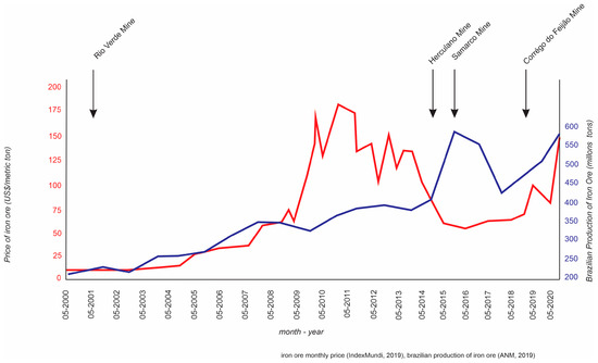
The development model assumed by human society over the last century is opposed to the Earth system’s resilience, which has resulted in global environmental problems such as global warming, desertification, depredation of geoheritage, etc. The concept of geoethics, proposed in 1993, was initially associated with ethical principles to mining and environmental, social and economic issues inherent to the exploration of these resources. Over the last few years, geoethics has turned to education, proposing a reflection on the way human beings relate to the geosphere, and particularly on the way geologists work during their academic and professional activities. In Brazil, geoethics entered the Brazilian Society of Geology scenario only from the end of the second decade of the 20th century and promoted changes in the academic and professional spheres. Full article
Show Figures

Figure 1

14 pages, 306 KiB  
Article
Geology and Environment: A Problem-Based Learning Study in Higher Education
by Tânia Pinto, António Guerner Dias and Clara Vasconcelos
Geosciences 2021, 11(4), 173; https://doi.org/10.3390/geosciences11040173 - 11 Apr 2021
Cited by 6 | Viewed by 3473
Abstract
We aimed to contribute to a shift in higher education teaching and learning methods by considering problem-based learning (PBL) as an approach capable of positively affecting students from a geology and environment (GE) curricular unit. In a convenience sample from a Portuguese public [...] Read more.
We aimed to contribute to a shift in higher education teaching and learning methods by considering problem-based learning (PBL) as an approach capable of positively affecting students from a geology and environment (GE) curricular unit. In a convenience sample from a Portuguese public university, two groups of students were defined: (1) an experimental group (n = 16), to which an intervention program (IP) based on PBL was applied, and (2) a comparison group (n = 17), subjected to the traditional teaching approach. For nine weeks, students subject to the IP faced four problem scenarios about different themes. A triangulation of methods was chosen. The study involved two phases: (1) qualitative (sustained on content analysis of driving questions raised by students, registered in a monitoring sheet) and (2) quantitative (quasi-experimental study, based on data from a prior and post-test knowledge assessment). The qualitative results point to the development of more complex cognitive-level questioning skills after increasing familiarity with PBL. The data obtained in the quantitative study, which included both a “within-subjects” and a “between-subjects” design, show higher benefits in the experimental group, documenting gains in terms of scientific knowledge when using the PBL methodology. Full article

2020

Jump to: 2024, 2023, 2022, 2021

13 pages, 615 KiB  
Article
The Impact of Multisensory Instruction on Geosciences Learning and Students’ Motivation
by Fábio Miguel Ferreira and Clara Vasconcelos
Geosciences 2020, 10(11), 467; https://doi.org/10.3390/geosciences10110467 - 19 Nov 2020
Cited by 5 | Viewed by 4455
Abstract
We live in a multisensory world. However, in classrooms, unisensory approaches are preferred, although they are unnatural and usually demotivating for youngsters. We conducted this mix-method study to investigate the possible effects of a multisensory approach on geosciences learning among students at a [...] Read more.
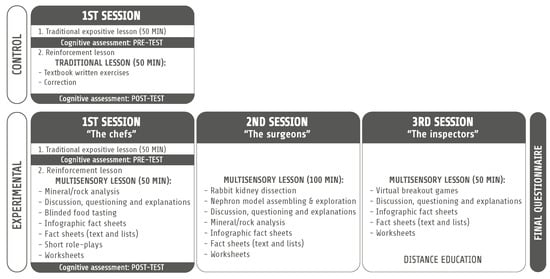
We live in a multisensory world. However, in classrooms, unisensory approaches are preferred, although they are unnatural and usually demotivating for youngsters. We conducted this mix-method study to investigate the possible effects of a multisensory approach on geosciences learning among students at a primary school in Porto, Portugal. The cognitive outcome was assessed using a pre/post-test design, while motivation and other attitudinal parameters were studied using an anonymous questionnaire. The results revealed a higher mean score in post-tests for students attending multisensory classes and high levels of motivation. Therefore, we consider that multisensory instruction has a positive impact on geosciences learning and motivation, and proper measures should be adopted to propel its full and optimal application in schools. Full article
Show Figures

Figure 1

8 pages, 194 KiB  
Brief Report
Earth2Class: An Effective and Easily Duplicable Model for Providing a Broad Impact of Cutting-Edge Science, Teacher Professional Development, and Inspiration for High School Students
by Michael J. Passow
Geosciences 2020, 10(10), 407; https://doi.org/10.3390/geosciences10100407 - 12 Oct 2020
Viewed by 2175
Abstract
We describe Earth2Class, a professional development model that connects classroom teachers with research investigators so that they and their students can learn about cutting-edge discoveries, long before mention is included in textbooks. Teachers and students attending “live” programs at the Lamont-Doherty Earth Observatory [...] Read more.
We describe Earth2Class, a professional development model that connects classroom teachers with research investigators so that they and their students can learn about cutting-edge discoveries, long before mention is included in textbooks. Teachers and students attending “live” programs at the Lamont-Doherty Earth Observatory of Columbia University or Zoom equivalents necessitated during the pandemic benefit through interactions that bring out the excitement of making new geoscience discoveries. Evidence of the effectiveness of Earth2Class (E2C) workshops is provided through reflections of the impact of E2C on student career choices, expanding teacher content knowledge, and attitudes provided by teachers, students, parents, and scientists. Full article
Back to TopTop