Article

Integrated Knowledge Systems Towards Flood Resilience and Sustainable Solid Waste Management in South African Urban Informal Settlements

by
Admire Mutsa Nyamwanza
1,*,
Katelyn Johnson
2,
Anele Mthembu
3,
Zwivhuya Caroline Tshivhundo
4 and
Natasha Brown
5
1
Institute for Global Health and Development, Queen Margaret University, Edinburgh EH21 6UU, UK
2
Department of Civil Engineering, Stellenbosch University, Stellenbosch 7602, South Africa
3
Institute of Natural Resources, Pietermaritzburg 3201, South Africa
4
Centre for Water Resources Research, University of KwaZulu-Natal, Pietermaritzburg 3201, South Africa
5
Joint Nature Conservation Committee, Peterborough PE2 8YY, UK
*
Author to whom correspondence should be addressed.
Sustainability 2026, 18(6), 2960; https://doi.org/10.3390/su18062960
Submission received: 1 February 2026 / Revised: 10 March 2026 / Accepted: 16 March 2026 / Published: 17 March 2026
(This article belongs to the Special Issue Sustainable Disaster Management and Community Resilience)

Abstract

The frequency and severity of extreme weather events have increased due to climate change, with floods emerging as one of the most common climate change-induced disasters the world over. South Africa is one of the countries most susceptible to floods in Southern Africa. Among the main factors exacerbating the impact of floods, particularly in urban areas in Africa, is waste. This article contributes solutions in dealing with the flood and solid waste challenges in urban informal settlements in South Africa through exploring the potential benefits of knowledge systems integration in tackling such challenges. Using the case of the Quarry Road West informal settlement in eThekwini Municipality, KwaZulu-Natal province, South Africa, the paper discusses the roles played by scientific, practitioner and local knowledge systems in responding to flood risk and solid waste challenges in this area over the years and the benefits that could be realised if these knowledge systems are deployed in a systematically integrated manner.

1. Introduction

Floods have emerged as one of the most devastating climate change-induced disasters the world over [1]. South Africa is one of the countries most susceptible to floods in Southern Africa. The country has experienced over 40 flooding disasters in the last 40 years, with far-reaching effects in terms of human and economic loss, costing the country upwards of US$2 billion in direct losses, particularly from impacts associated with infrastructural damage [2]. In recent years, the April/May 2022 flood in the country’s KwaZulu-Natal province was one of the most devastating—claiming more than 400 lives, destroying over 4000 houses, and displacing close to 40,000 residents [3]. Among the main factors exacerbating the impact of floods particularly in urban areas in developing countries, including South Africa, is solid waste [4]. Flood resilience in urban areas, particularly in Africa, should include measures towards sustainable solid waste management. This nexus is central to achieving Sustainable Development Goals (SDGs), specifically SDG 11 (Sustainable Cities and Communities) and SDG 6 (Clean Water and Sanitation), yet the integration of sustainable solid waste management into flood disaster management remains under-researched in the Global South. A critical component of both flood resilience and sustainable solid waste management is the integration of knowledge systems. Knowledge systems can be conceptualised as comprising agents or players, practices and institutions that organise the production, transfer and use of knowledge [5]. In our discussion, three knowledge systems are identified: scientific, local, and practitioner knowledge systems. While scientific knowledge refers to systematised knowledge that can be replicated and validated by recognised experts through a series of logical and empirical methods, local knowledge refers to the place-based experiential knowledge of a community accumulated over generations of living in a particular environment [6]. Practitioner knowledge on the other hand is knowledge held and emanating from practitioners such as resource managers, government bureaucrats, and players in non-governmental, developmental and civil society organisations [7].
Our research specifically focuses on one of the most vulnerable contexts in urban areas, particularly in Africa—urban informal settlements. This is because: (a) informal settlements are often built on environmentally fragile locations such as river banks, steep slopes, flood plains and coastal shores which have a high exposure to floods; (b) the high levels of poverty and illiteracy of residents result in their lowered capacity to deal with the consequences of such impacts; (c) the political and institutional marginalisation of these localities emanating from their non-recognition in the broader formal human settlements fabric, often resulting in the absence of meaningful flood risk-reducing infrastructure such as storm water drains, bridges and proper roads [8]; and (d) the unplanned nature of physical infrastructure, which somehow leads to the degradation of ecological infrastructure—ecological infrastructure which is supposed to confer some level of flood resilience, but which is compromised.
In South African urban informal settlements, the solid waste problem is a primary driver of flood risk [9]. Unlike formal suburbs, these areas often generate a mix of standard household waste, bulky debris, and hazardous materials due to the lack of formal collection services. This waste accumulates in open spaces and drainage channels. The relationship is cyclical and compounding: (a) uncollected waste blocks both grey infrastructure (stormwater drains) and ecological infrastructure (wetlands and streams), reducing the hydraulic capacity of the land and causing man-made flash floods even during moderate rainfall, and (b) when flooding occurs, it mobilises uncontrolled waste, including toxic substances and faecal matter from pit latrines, spreading it downstream. While floodwaters eventually recede, these pollutants remain in the soil and water systems, integrating into the food chain and creating long-term health crises that outlast the physical destruction of the flood.
This study therefore sought to answer three broad questions vis-à-vis flood resilience, waste management and knowledge systems:
  • How have waste challenges exacerbated flood risk in urban informal settlements in South Africa?
  • What type of knowledge and knowledge actors have informed flood risk response and waste management in urban informal settlement areas in South Africa?
  • What platforms and forums can be used to integrate knowledge systems towards flood resilience and sustainable waste management in urban informal settlement contexts?
While previous studies have explored knowledge co-production and participatory governance in climate adaptation and disaster risk reduction, relatively few studies have examined the intersection of flood resilience and solid waste management in informal settlements through an integrated knowledge systems lens. In many rapidly urbanising contexts, waste accumulation contributes significantly to flood risk by blocking drainage systems and degrading ecological infrastructure, yet responses to these challenges often remain fragmented across sectors and institutions. By exploring the interaction between scientific, local, and practitioner knowledge systems, this study provides a novel framework for knowledge co-production. The expected scientific contribution is the development of an integrated model that treats waste management not merely as a service, but as a critical component of climate adaptation and urban flood resilience, particularly in marginal urban environments.

2. Materials and Methods

2.1. Approach

The study was anchored on a case study approach, with findings emanating from a purposely selected urban informal settlement area in South Africa: the Quarry Road West informal settlement in eThekwini Municipality, in KwaZulu-Natal province. The case study area is discussed in more detail in Section 2.2. To move beyond siloed analyses, the research employed an integrated nexus framework—with data collection interfacing topics on flood risk and waste management, e.g., vis-à-vis hydrological connectivity (i.e., how uncollected solid waste obstructs natural and artificial drainage systems, increasing flood depth and duration) and governance intersections (i.e., the extent to which local municipal mandates for flood risk management and solid waste management overlap or fragment in informal contexts). This approach treats flood risk and solid waste management not as parallel issues, but as a coupled socio-ecological system. For data collection, a mixed methods approach was employed involving different qualitative techniques, to include both secondary and primary data as follows:
(a)
Literature and document reviews—reviewing relevant published and grey literature such as journal articles, book chapters, occasional papers, national and subnational policy documents.
(b)
Key informant interviews—which involved interviewing 9 people, including officials at the local municipality level, officials in relevant provincial government departments, university researchers and officials in non-governmental organisations who have worked in the case study area vis-à-vis flood risk and waste management. The interviewed officials were purposely selected due to their involvement in flood risk and waste management issues in eThekwini Municipality over the years. Specific questions for key informants covered issues on flood risk and flood risk response, solid waste challenges and management, and knowledge systems integration.
(c)
Two focus group discussions with residents of the case study informal settlement area—as with the key informant interviews, the focus group discussion guide included questions on flood risk and flood risk response, solid waste challenges and management, and knowledge systems integration. The guide also utilised relational mapping, asking residents to identify ‘hotspots’ where waste accumulation and flood-water stagnation occurred simultaneously, capturing the lived reality of the waste–flood nexus. In selecting participants, residents who have lived in the area long enough to have experienced at least one flood event were targeted. The selection also took into consideration men and women of different ages and living at different geographical points in the informal settlement.
(d)
Two stakeholder workshops—one which brought together different government and non-governmental officials as well as academic researchers, and one with informal settlement residents. The selection of attendees for these workshops was guided by snowball sampling. The workshops were conducted following a 3-stage format. Firstly, an introduction of the project, workshop aim and objectives. Secondly, participants were divided into 2 groups, i.e., a flood-focus and a waste-focus group, for extensive discussions in breakaway sessions. The final stage involved participants reporting back on their deliberations in plenary, as well as addressing questions from all attendees and reaching conclusions vis-à-vis co-benefit solutions that simultaneously reduce flood risk and improve waste management.
(e)
Visual techniques, which involved direct observations and the collecting of photographic evidence of the nature and positioning of key infrastructure, natural resources and geographical points of interest directly affected by flood events and waste challenges in the case study area. This made it possible to observe the positioning and nature of housing structures in the informal settlement, population density, distance of housing structures from the nearby river, waste disposal points, and drainage systems in and near the informal settlement area. The objective was to obtain a clear appreciation of the lived realities, as well as the experienced and potential effects of flood events and waste challenges in the study areas.
Participatory systems mapping processes were also used during workshops and group discussions. This was the primary tool for the integration of flood risk and waste issues. Participants co-created visual maps that traced the causal loops between poor waste disposal, drain blockage, and localised flooding. This process vividly demonstrated how solving one issue (waste) is a prerequisite for managing the other (flood) in the case study area. Participatory mapping incorporates local experiences and knowledge into risk-profiling efforts and fosters collaboration between different stakeholders towards crafting solutions to flood-risk and waste challenges [10]. Thematic analysis was used for organising and analysing the different sets of data obtained from the various approaches. Integration in analysis was achieved during coding by using a matrix approach, where, for example, ‘flood risk’ and ‘solid waste’ were not just independent themes but were analysed through intersection codes such as waste-induced flooding or integrated community-based response.
The Integrated Knowledge Systems Framework, developed as a key output of this study, underwent a formative iterative validation process to ensure its practical utility and institutional alignment. The validation process was as follows:
  • Validation participants: The draft framework was presented to a subset of the original stakeholder group (n = 13), including three municipal officials (from Cleansing and Solid Waste Unit, and Development Planning, Environment and Management Unit), two NGO practitioners, two academic researchers and six residents from the Quarry Road West informal settlement who participated in previous focus groups.
  • Selection of participants: Participants were selected based on their ‘expert-by-experience’ status (i.e., residents with long-term flood exposure), their institutional mandate (i.e., officials responsible for implementing the policies outlined in the framework) and their expertise and knowledge on flood and/or waste issues in South African urban informal settlement areas (i.e., academic researchers and practitioners).
  • Evaluation parameters: The framework was assessed against four key criteria:
    Feasibility: Can the proposed integration of hydro-environmental data and community knowledge be achieved within current municipal resource constraints?
    Clarity: Are the linkages between the ‘Framework Process Flow’ and ‘Quantitative Aspects’ (e.g., the HEC-RAS modelling) understandable to non-technical stakeholders?
    Institutional Compatibility: Does the flow of information align with existing reporting structures in eThekwini Municipality?
    Inclusivity: Does the framework adequately represent the lived realities of informal settlement residents?
  • Feedback incorporation: Initial feedback indicated that the ‘Framework Process Flow’ was too top-down. In response, we added the ‘Community-based organisations’ and ‘Community Health Workers’ as explicit knowledge sources and we also included Public Health Campaigns as one of the primary dissemination means to ensure the technical modelling propositions (i.e., Quantitative Aspects) reach the residents in an actionable format.

2.2. Case Study Context

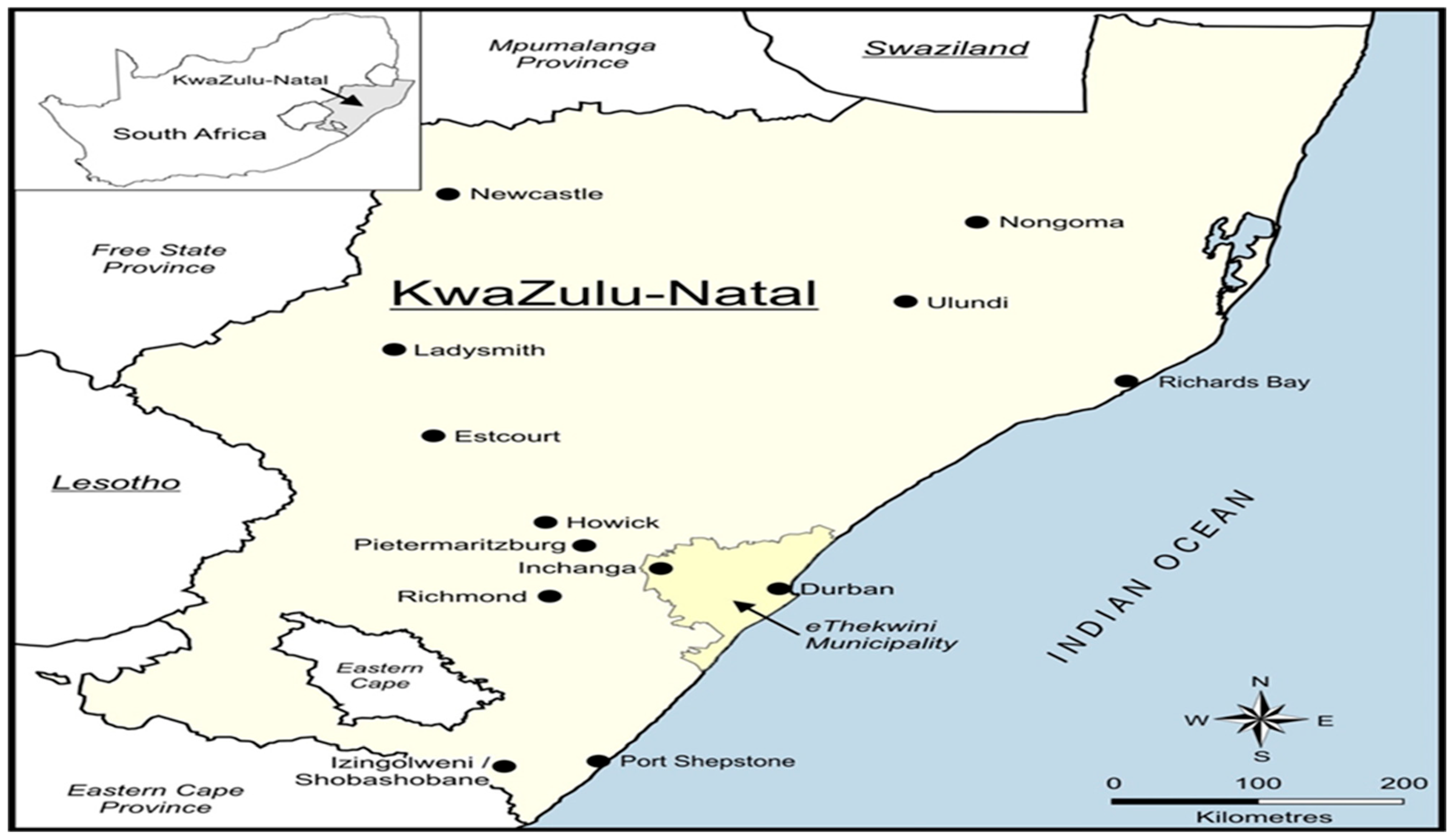
As noted in Section 2.1, this study used the case of the Quarry Road West informal settlement which is in eThekwini Municipality within KwaZulu-Natal province (Figure 1). eThekwini Municipality was purposely selected for various reasons. Firstly, there is a marked increase in informal settlements and informal settlement dwellers in eThekwini and, as a matter of fact, eThekwini has the largest number of informal settlements of any municipality in South Africa [10]. Approximately 314,000 households make up 580 urban informal settlements, or a quarter of the municipality’s population [11]. Secondly, due to the challenging topography of eThekwini, urban informal settlements are often found on steep slopes, within floodplains, near mine dumps or heavy industrial areas (e.g., in Wentworth, Durban), and even on landfill sites (e.g., along Foreman and Kennedy Road, Durban) [12]. Due to the location and nature of informal settlements, they are vulnerable to natural disasters such as floods [13]. Precarious and poor-quality housing offers no protection against flooding or extreme temperatures. Flooding is common in informal settlements due to the proximity of houses to rivers, often the closest water resource. In fact, 11,000 households in informal settlements in eThekwini Municipality are within the 1:100-year flood line [14]. KwaZulu-Natal province, within which eThekwini Municipality is located, is the wettest province in the country, with an average annual rainfall ranging between 650 mm and 1400 mm, which is greater than the national average [15].
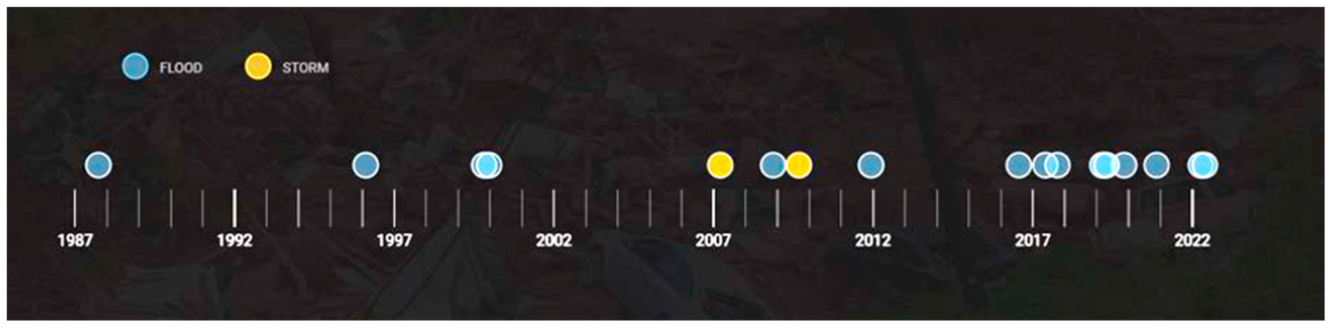
Tidal records collected near Durban harbour since 1970 show that the sea level has increased by 2.7 mm a year, and scientists project that, because of climate change, the level of the sea could rise by between 0.3 m and 1 m by 2100 [17]. eThekwini Municipality has several rivers and streams, including the Umgeni, Umhlatuzana, and uMlazi rivers. In fact, it has more than 800 km of water streams [18]. During periods of heavy rainfall, many of the surrounding areas are unavoidably affected by flooding. Many rivers and drainage lines are traversed by bridges to accommodate transport routes and service lines. During extreme flood events, these become blocked with plant debris (mostly alien invasive plants), unmanaged solid waste (particularly non-recyclable plastics that escape the informal reuse chain) and sediment, leading to major infrastructure damage and often extremely costly failure [19,20]. Figure 2 shows a timeline of the occurrence of floods and storms in eThekwini from 1987 to 2022. The pattern clearly shows a marked increase in flood events in the municipality from 2017 onwards. The eThekwini Metropolitan Area produces over 1.8 million tonnes of solid waste annually and over half the amount of this waste is not collected and treated through formal waste collection systems, resulting in large amounts being dumped illegally [21].
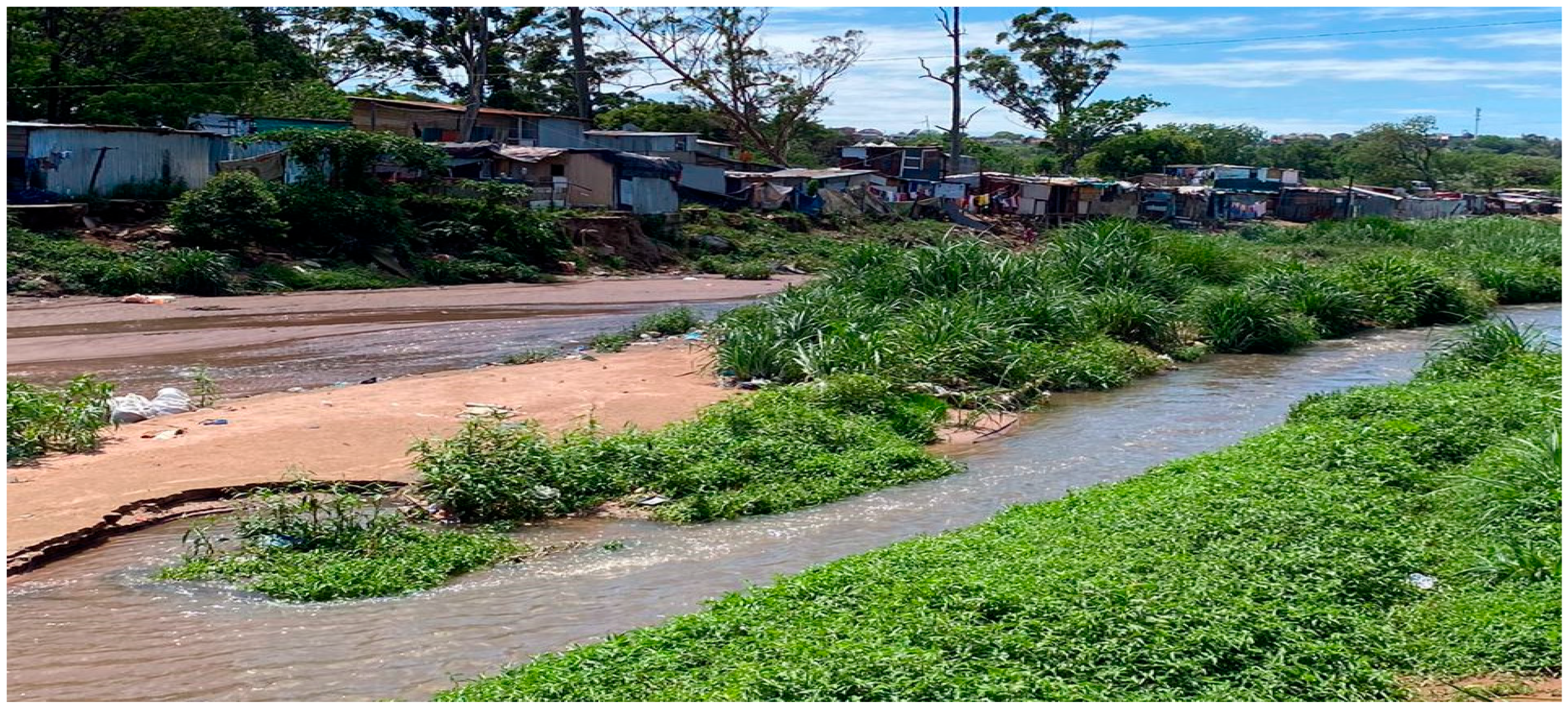
The Quarry Road West informal settlement is located approximately 9.5 km from the Durban Central Business District. The informal settlement is located within the Palmiet River Catchment directly along the Palmiet River flood plain. The informal settlement was established in 1984 [22] and as of 2019, there were over 2400 people living in the area [23]. The informal settlement is characterised by poverty, high unemployment, lack of basic social services, high population density, and poor housing conditions, with over 95% of housing structures built using low-grade corrugated iron sheets [23,24]. The Quarry Road West informal settlement is prone to flooding, mainly because of the Palmiet River which passes through it (see Figure 3), at an elevation of 18 m above sea level [25].
While formal kerbside waste collection is limited, waste practices in settlements like Quarry Road West are characterised by a dual reality of environmental dumping and survivalist reuse [26]. Residents frequently repurpose materials such as corrugated iron, timber, and plastic sheeting for structural reinforcements of their dwellings. Additionally, as in most informal settlement areas in South Africa, an active informal recycling sector exists where waste pickers or reclaimers extract high-value recyclables, primarily PET plastics, cardboard, and scrap metal to sell to mid-level buy-back centres [27]. Despite these localised reuse and recycling efforts, a massive volume of non-recyclable residual waste remains unmanaged. Without consistent municipal clearing, this waste is either disposed of in communal heaps, burnt, or discarded directly into the Palmiet River and its banks.

3. Results

3.1. Interaction of Flood Events with the Waste Situation in eThekwini

As noted in the introduction section, flood events in developing country contexts feed into many other factors influencing vulnerability, with solid waste being one of these. In the case of eThekwini urban informal settlement areas, the absence of meaningful flood risk-reducing infrastructure such as storm water drains is a critical factor influencing vulnerability. An increase in population, urbanisation and industrialisation has also resulted in the increased production of solid waste. Other factors relating to the increase in solid waste, as emerging from the focus group discussions with Quarry Road West residents and the stakeholder workshop with key experts, are illegal dumping, littering, lack of management of municipal staff, the development of peri-urban areas and the expansion of informal settlements. Participants in focus group discussions emphasised that waste accumulation significantly worsens flooding in the settlement. One community member noted:
“When the drains and river are blocked with plastic and other waste, the water cannot pass through, and it floods our homes very quickly during heavy rains.”
(Focus group discussion participant)
Beyond the physical blockage of infrastructure, the interaction between floodwaters and unmanaged waste triggers a cascade of environmental pollution. During flood events, stagnant water mixes with accumulated household refuse and human excreta from damaged sanitation systems, creating a serious health hazard in and around the informal dwellings. This uncontrolled pollution leads to the leaching of hazardous chemicals and organic pollutants into the soil and local groundwater, long outlasting the flood event itself. The health implications of this pollution are severe for Quarry Road West residents. The convergence of solid waste and floodwater creates ideal breeding grounds for disease vectors, increasing the prevalence of waterborne diseases such as cholera and dysentery, as well as skin infections and respiratory issues. Focus group participants noted that children are particularly vulnerable, as they often come into direct contact with polluted silt and waste remains during the cleanup process.
Planning and risk mitigation measures from the municipality are also typically limited in informal settlements. The eThekwini Municipality waste management sector itself has been vulnerable to floods [28]. Flood events throughout the years have damaged municipal waste assets such as waste collection vehicles, landfills and other infrastructure such as roads, water and sanitation. A municipal official interviewed during the study also highlighted institutional challenges in managing waste and flood risks in informal settlements:
“Waste collection services in informal settlements are difficult to maintain consistently because of access constraints and limited infrastructure, which unfortunately contributes to waste accumulating in drainage channels.”
(Key informant interview)
Poorly managed solid waste in eThekwini informal settlements, including in the Quarry Road West informal settlement area, has contributed to the infilling of watercourses, for example through illegal dumping and waste accumulation. This has led to the clogging of stormwater systems, bridges and culverts designed to rapidly convey water away, and thus amplifying the impacts of flooding and causing significant damage to both stormwater and sewage networks [19]. This damage to sewage infrastructure further exacerbates the environmental health crisis by releasing untreated effluent into the same spaces where residents live and work.

3.2. Knowledge Systems on Flood Resilience and Waste Management in eThekwini

Three knowledge systems were identified as actively utilised in eThekwini Municipality urban informal settlements, and in the Quarry Road West informal settlement more specifically. These are scientific, practitioner and local knowledge systems.

3.2.1. Scientific Knowledge

Scientific knowledge from academics, scientists and researchers has been critical for understanding flood risk and the waste challenge in the Quarry Road West informal settlement over the years. Table 1 highlights the various scientific knowledge actors (key players and institutions) who have been active in Quarry Road West vis-à-vis flood risk and waste management, the different types of information/data provided and the formats in which the data has been released.
From Table 1, it is clear that the Quarry Road West scientific knowledge base for both flood risk and waste management is robust in its technical breadth—spanning complex hydrological modelling data and quantitative vulnerability factors from different players. What was critical, however, which is at the core of this article, was to devise ways of enhancing this knowledge’s contextual accessibility, usability, and operational integration towards ensuring real-time flood risk response and sustainable waste practices in the settlement.

3.2.2. Practitioner Knowledge

Different practitioner institutions such as civil society, non-governmental organisations and government entities, have been active in Quarry Road West working on issues related to flood risk as well as waste management. Most of these issues have had to do with environmental education, flood vulnerability awareness, habitat restoration, early warning, and invasive alien plant eradication. Table 2 shows the different practitioner knowledge actors (key players and institutions) who have been active in the Quarry Road West informal settlement vis-à-vis flood risk and waste management over the years, the different types of information/data released and the formats in which the data has been released.
Table 2 shows that the Quarry Road West practitioner knowledge for both flood risk and waste management is diverse—spanning disaster management plans and spatial risk assessments. Whilst practitioner knowledge for the area also captures community perceptions of risk, the flow of actionable information, however, seemed siloed within specific government departments and NGOs. The main information repositories for this knowledge (i.e., institutional websites and technical project reports) also appeared to create an ‘accessibility gap’ as these platforms often bypass the socio-technical realities of informal settlement residents, many of whom lack consistent internet access and/or technical literacy.

3.2.3. Local Knowledge

Quarry Road West informal settlement residents have not been ‘helpless’ victims of floods and waste challenges. They have, over the years, relied on local and experiential knowledge accumulated through oral transmission as well as through past learning and experiences to deal with the challenges. Some of the main local indicators used in mapping flood vulnerability in the area, as emerged from group discussions, include the following:
  • Amount of rainfall—with increasing rains being a sign of high likelihood of flooding.
  • Flow velocity—with increasing velocity of water in nearby rivers indicating the likelihood of flooding.
  • Nature of soil—with community members able to identify highly erodible soil with a potential to expose one’s housing structure to flooding.
  • Accumulated waste—which was said to always lead to the blockage of storm drains, compounding flood situations.
  • Proximity to main roads—this is because there are no storm drains in the area along the main roads which are close to the informal settlement under focus. Community members highlighted that the major road nearest the settlement appears slightly sloped towards human settlements such that all the run-off from the road which is supposed to find its way to the nearby river ends up in the settlement.
  • Lack of land ownership has also made urban informal settlement dwellers vulnerable to floods and compromised their resilience—since they are considered illegal settlers, they are not allowed to build stronger permanent structures which can better withstand (some of the) floods which they experience.
Residents emphasised the importance of experiential knowledge in identifying flood risk areas within the settlement. As one participant explained:
“We know which areas flood first because we have seen it happen many times. When the river starts rising and the rain continues, we warn our neighbours and move things to higher ground.”
(Focus group discussion participant)
Table 3 shows the different types of local knowledge released vis-à-vis floods and waste, and how that information can be accessed.
It is clear that Quarry Road West residents demonstrate a sophisticated multi-layered understanding of their environment, e.g., their ability to link hydrometeorological indicators like flow velocity directly to anthropogenic factors such as waste accumulation. Whilst the community possesses critical granular real-time information on both flood risk and waste management as shown in Table 3, it was apparent that there is need to close the knowledge–policy–practice gap through systematically integrating this knowledge with both scientific and practitioner knowledge.

3.3. Knowledge Systems Integration in Flood Risk Response and Waste Management

This study identified specific instances of knowledge integration within the Quarry Road West informal settlement. Currently, these efforts are characterised by fragmented but high-impact collaborations focused on three primary areas: (a) the co-generation of flood early warning systems, (b) community-led river clean-up initiatives, and (c) localised catchment rehabilitation projects. These existing touchpoints between residents, NGOs, and researchers provide the practical foundation upon which a more structured framework can be built. These initiatives are explained in the following subsections.

3.3.1. Generation and Distribution of Flood Early Warning Systems

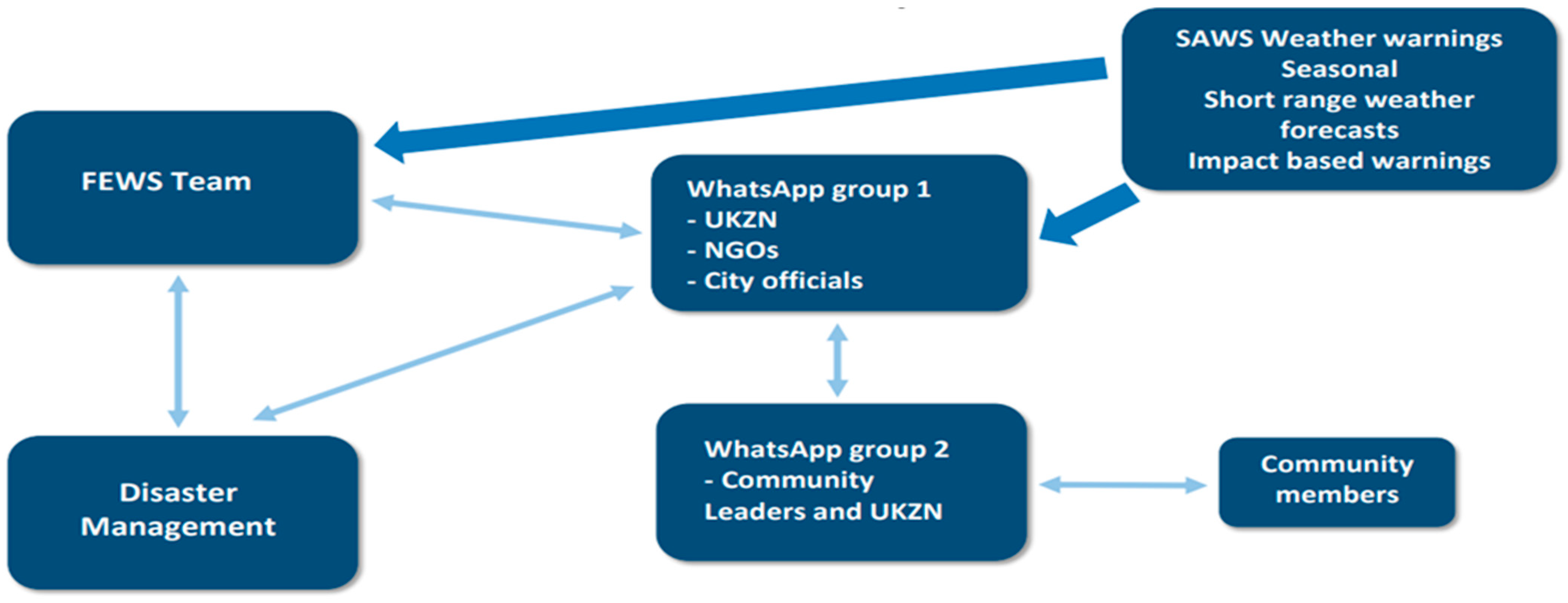
The Community-Based Flood Early Warning System (CBFEWS) was inspired and enabled by eThekwini Municipality’s Coastal Stormwater and Catchment Management Department’s use of the flood forecast early warning system (Delft-FEWS). This was used to produce early warnings within the municipality around 2014, identifying hotspots for disaster risk reduction and management [29]. The system integrates information from weather warnings produced by global forecasts and the South African Weather Service (SAWS), with rain and river observations, and data from radar which monitors storm cells, to produce localised flood risk warnings. This system provides real-time data to the municipality on storms, rainfall, and river levels—with the initial purpose of protecting strategic assets and resources throughout the city.
The CBFEWS has been developed as a bottom-up approach, through the co-production of knowledge in a local governance platform which includes local government (eThekwini Municipality), researchers from UKZN, civil society organisations, local environmental champions, and community members. Residents in the Quarry Road West informal settlement, for example, have co-produced and ground-truthed risk maps of their community, and have developed flood risk response strategies with UKZN researchers—which include amplifying early warnings among community members, evacuation of residents to higher ground before water levels rise, and construction of barriers to protect housing structures and household properties before flood events. The community also now fully understands the spatial distribution of flood risk in their settlement.
The CBFEWS operates in such a way that researchers from UKZN’s School of Built Environment and Development Studies transfer flood risk warnings and rainfall and river level data from municipal officials to local community leaders through WhatsApp groups. In turn, community members share updated information on river levels, as well as real-time photographs, videos and information on the settlement and the flood risk on WhatsApp groups (see Figure 4—Nb: The thicker, darker arrows in the Figure signify more frequent and more structured communication whilst the thinner, lighter shaded arrows signify ad hoc and more informal communication).
Community members highlighted the importance of communication networks for early warning. One participant explained:
“The WhatsApp group helps us warn each other quickly when the river starts rising. People send pictures and messages so that others can prepare or move away from dangerous areas.”
(Workshop participant)

3.3.2. River Clean-Up Projects

In the aftermath of the 2022 floods, the City of Durban launched a R719 million river clean-up and flood protection project, aimed at serving as a model to cushion other vulnerable cities in Africa from the impacts of climate change-induced floods. In order to combat the scale of pollution within eThekwini Municipality and reduce the amount of solid waste in rivers which exacerbates flood risk, initiatives have been introduced under the project across the municipality through various organisations and programmes.
From discussions with municipality officials during key informant interviews, it was noted that the lower section of the Palmiet River (where the Quarry Road West informal settlement is located) was selected for project activities, as that area has been identified as a pollution ‘hot spot’ following assessments by the municipality. The entire project was initiated as a proof-of-concept project for the uMngeni Ecological Infrastructure Partnership (UEIP). The UEIP is a partnership bringing together a diverse group of organisations from government, business, academia and civil society committed to finding ways of better integrating ecological infrastructure solutions into water resource management through collective participation and coordination of activities in the greater uMngeni River catchment.
Under the River Clean-Up project, university researchers and local community members identify solid waste disposal points in rivers. Non-governmental organisations (NGOs) are then engaged to implement the project, pivoting on their experience of working in and with local communities. NGOs that have been part of this project include, Green Corridor, PetCo, Adopt a River, Wildlands Conservation Trust, and Oceans Alive Conservation Trust. The project also requires that local community members be among those hired to conduct the actual clean-ups so that communities directly benefit from these initiatives.

3.3.3. Catchment Rehabilitation Projects

The Palmiet Catchment Rehabilitation Project (PCRP) is one of eThekwini Municipality’s major catchment rehabilitation projects. The PCRP involves a partnership between eThekwini Municipality, researchers at UKZN and civil society organisations. The initial scope of work of the PCRP, as outlined by eThekwini Municipality’s Water and Sanitation (EWS) engineers, was finding technical solutions to address the risk of flooding and pollution in the lower reaches of the Palmiet River, as it flows through the Quarry Road West informal settlement into the uMngeni River. Through initial engagements with officials from EWS and the Environmental Planning and Climate Protection Department (EPCPD), UKZN researchers began to shift the focus of the workplan constructed by the municipality, from being top down, technical and managerial, to one that started with the building of relationships between all actors in the catchment around water and climate governance.
An actor mapping exercise was undertaken, and new actors were drawn into the PCRP through the efforts of the UKZN researchers. ‘Actors’ refer to individuals, organisations, or groups that actively participate in and influence the process of improving economic and social conditions within a specific context. As a result, a governance arena for building sustainability in the catchment began to be established. The EPCPD assumed a leadership role from a climate change perspective in the newly forming PCRP partnership, which by early 2015 comprised actors from the municipality, the university and community-based organisations. PCRP interventions, over the years, have included constructing wetlands, weirs and gabion banks to reduce the impact of the river on both the Quarry Road West informal settlement community and the uMngeni River, and to develop waste management and storm water systems to reduce the impact of the community on the river.

3.3.4. Critical Evaluation and Pathways for Expanded Cooperation

While the co-generation of early warning systems, river clean-ups, and catchment rehabilitation represent significant strides in knowledge integration, a critical review suggests that these efforts, in their current state, are insufficient for long-term resilience with respect to response to flood risk and waste management in informal settlement contexts.
The “Sufficiency” Gap
The existing initiatives operate largely as “islands of excellence”—successful within the Quarry Road West context but lacking the institutional ‘glue’ to survive without external researcher or NGO facilitation. Specific gaps include:
  • Temporal Fragility: Many projects are grant-funded or linked to specific research cycles (e.g., UKZN-led interventions), risking collapse once academic oversight withdraws.
  • Informal–Formal Friction: While WhatsApp groups facilitate rapid communication, this data is rarely integrated into the formal municipal disaster management protocols in a standardised way.
  • Scale Mismatch: River clean-ups address the symptoms of waste in the river but do not yet integrate with the formal municipal waste collection schedule for informal settlements.
Proposals for Expanded Cooperation
To move beyond fragmented success, the following pathways for expanded cooperation are proposed:
(a)
Institutionalisation of the “Knowledge Broker” Role: Transitioning the role of researchers (UKZN) to permanent community-municipal liaisons embedded within eThekwini Municipality. This would formalise the bottom-up data flow from informal settlements into city planning.
(b)
Circular Economy Integration: Expanding the “River Clean-up” model into a “Waste-to-Value” partnership under formal ecological partnership programmes. This involves bringing in private sector recyclers to create a formal market for the waste collected by residents, ensuring the financial sustainability of clean-up efforts beyond municipal grants.
(c)
Unified Digital Governance Platform: Moving from informal WhatsApp groups to a dedicated municipal dashboard where community-fed “ground-truth” data (photos/water levels) is legally recognised within formal early warning system generation platforms as an official trigger for municipal emergency responses.

4. Discussion

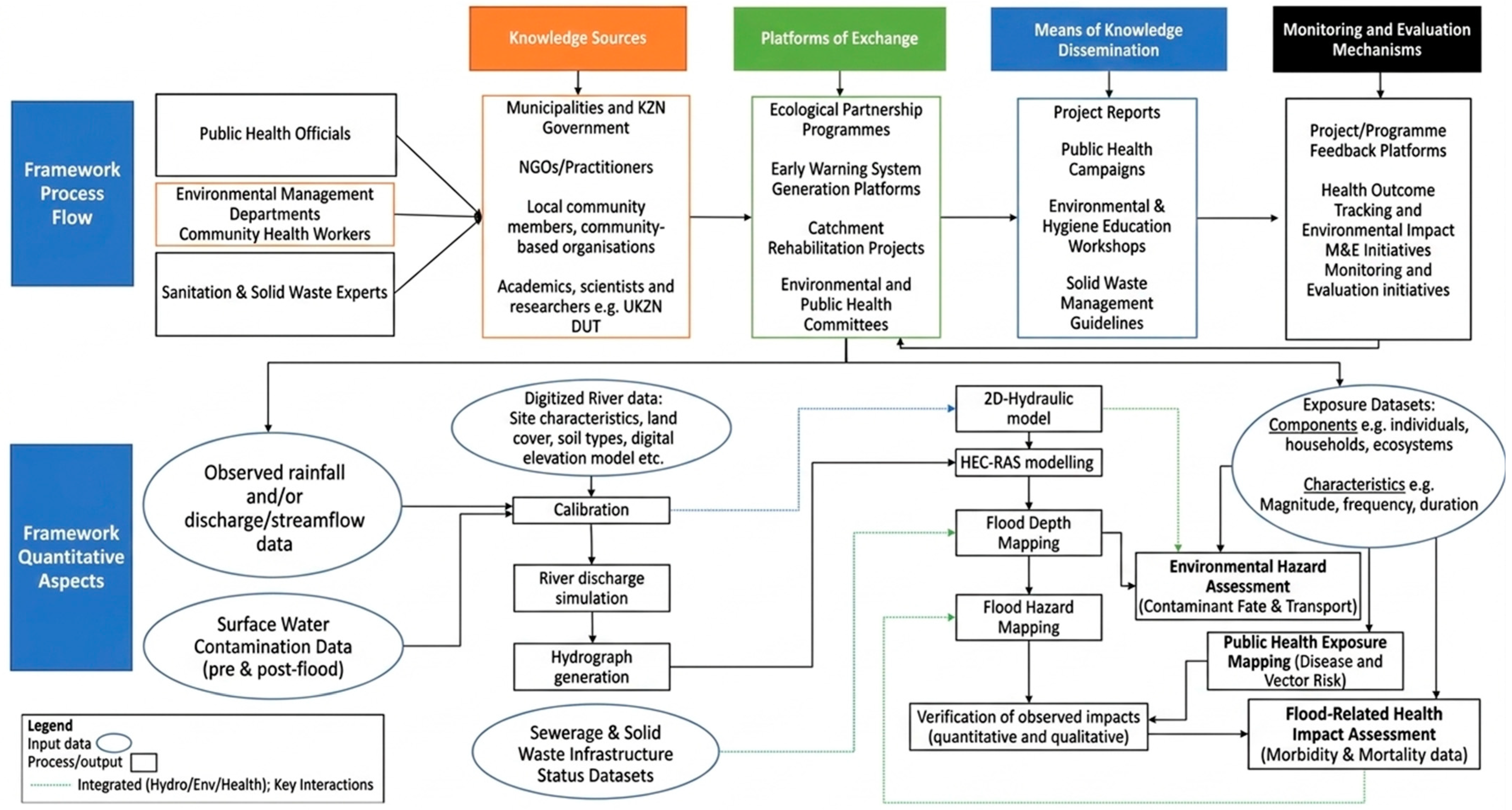
Having assessed all the factors involved in the knowledge generation, knowledge sharing and collaborative arrangements regarding different knowledge systems around flood risk and waste management in the case study area, we developed a framework for integrating knowledge systems towards flood resilience and sustainable solid waste management in South African urban informal settlements and similar contexts (Figure 5). This framework includes a process flow which shows knowledge sources, platforms of exchange, means of knowledge dissemination, and suggested monitoring and evaluation mechanisms. It also includes key quantitative aspects of the framework, which incorporates the analysis of observed hydrological data together with local flood risk and waste management information. This includes the hydrological modelling of flow characteristics through flood frequency analysis and the generation of a hydrograph, which depicts how the drainage basin responds to a period of rainfall. Hydrologic Engineering Centre’s River Analysis System (HEC-RAS), highlighted in the framework, is a simulation software that can be used to model the hydraulics of water flow through natural rivers and other channels. The developed framework represents a shift from siloed disaster management toward a transdisciplinary approach that integrates scientific, practitioner, and local knowledge systems. By mapping the ‘framework process flow’ against ‘framework quantitative aspects’, the model specifically addresses the converging crises of climate change, environmental degradation, and public health in informal settlements. Within the proposed framework, hydrological modelling approaches such as flood frequency analysis and HEC-RAS are presented as potential analytical tools that municipalities can use to support flood vulnerability assessment and mitigation planning. These tools were not applied as part of the empirical analysis in this study; rather, they are included to illustrate how quantitative modelling can complement scientific, practitioner, and local knowledge systems in future flood risk management applications.
At the core of the framework’s quantitative dimension is the recognition that climate change is likely altering precipitation patterns and increasing the frequency of extreme weather events in South African urban centres. While the existing CBFEWS in Quarry Road West provides valuable real-time monitoring through low-cost sensors, the proposed framework highlights the potential role of hydrological modelling tools such as HEC-RAS in supporting longer-term flood risk assessment and planning. Such tools could assist municipalities in exploring potential flood scenarios, identifying areas of long-term vulnerability, and informing land-use planning in high-risk informal settlement environments. The framework also explicitly links flood resilience with environmental protection. In informal settlements, waste accumulation is not merely an aesthetic concern but can compromise the functioning of drainage and the capacity of hydraulic infrastructure. The inclusion of datasets related to the constitution of solid waste, together with surface water contamination data, emphasises that environmental health is an important component of flood risk mitigation. By incorporating catchment rehabilitation initiatives, community health workers, and health outcome tracking within the framework, the approach recognises that flood resilience should be assessed not only through infrastructure performance but also through the sustained wellbeing of residents. As discussed in Section 2, the framework was validated with key stakeholders and informal settlement residents to ensure its feasibility and practical relevance.
It is envisaged that the framework can essentially be used as a guiding tool primarily by municipalities, but also by government departments to organise and implement processes for the integration of knowledge on flood risk and flood risk response, as well as waste management, emanating from various actors holding different scientific, practitioner and local knowledges (e.g., see actors mentioned under the ‘Knowledge Sources’ box in the framework in Figure 5). This is key, particularly for informal settlement areas, where critical services and interventions for flood resilience and effective waste management are often inadequate. As recommended in validation exercises, we envisage the framework being championed by local municipalities, since they have convening powers in terms of bringing different players together in different forums and platforms (see examples of such platforms and forums under the ‘Platforms of Exchange’ box in the framework). Local municipalities are also the primary authorities vis-à-vis service delivery and building the capacity of other players in their areas of jurisdiction, in relation to such issues as flood risk response and waste management. Integrating scientific flood modelling approaches with local and practitioner knowledges via a clear framework, as presented in Figure 5, will assist local authorities to expand platforms of information exchange, identify the most vulnerable, monitor and evaluate efforts, and pinpoint the underlying and differential causes of flood risk, including attendant waste challenges in specific contexts.

5. Conclusions

This study demonstrates that flood resilience in South African urban informal settlements is inextricably linked to sustainable solid waste management. The findings from the Quarry Road West case study reveal that while individual initiatives for knowledge integration in dealing with flood risk and waste challenges exist, they often function in an ad hoc and fragmented manner. The transition from siloed flood resilience and waste management approaches to a transdisciplinary approach vis-à-vis knowledge systems integration in addressing these challenges is essential. By implementing the developed Integrated Knowledge Systems Framework, municipalities can move beyond reactive emergency responses toward a proactive model that synchronises scientific modelling, practitioner expertise, and local experiential knowledge. Such integration not only identifies the underlying drivers of flood risk such as the blockage of grey and ecological infrastructure by solid waste, but also fosters community ownership and more cost-effective, sustainable interventions.
The primary scientific contribution of this research is the conceptualization and validation of an integrated model that treats solid waste management as a core pillar of climate adaptation rather than a standalone municipal service. Positioning our proposed framework as primarily conceptual and governance-oriented, we provide the necessary institutional scaffolding for future technical applications. Unlike traditional flood resilience models that focus solely on hydrology, this framework introduces a nexus approach, mapping the ‘Framework Process Flow’ against ‘Quantitative Aspects’ to show how non-traditional data such as waste accumulation rates can be integrated into standard hydraulic equations. By incorporating datasets on sewerage, solid waste infrastructure status, and surface water contamination into hydraulic modelling (e.g., HEC-RAS), this study provides a novel methodology for assessing flood risk in the complex, ‘man-made’ hydraulic environments of informal settlements in the Global South. As climate change increases the frequency and intensity of extreme precipitation events in Southern Africa, the vulnerabilities of informal settlements are set to escalate. This study underscores that flood risk management and broad climate resilience in these contexts cannot be achieved through physical infrastructure alone. The proposed framework highlights that proactive climate adaptation requires simulating future flood scenarios under various climate projections to guide urban planning activities (including waste management). Furthermore, by prioritising catchment rehabilitation projects among ‘Platforms of Exchange’, the framework suggests that nature-based solutions can serve as vital buffers against the heightened hydraulic energy brought about by climate-induced flooding.
While this study provides a robust theoretical and validated framework, a primary limitation is that the quantitative modelling tools (such as HEC-RAS and flood depth mapping) were presented as illustrative components rather than being empirically applied. The study does not provide a site-specific hydraulic output, but rather the ‘governance blueprint’ required to make such modelling accurate in informal settings. Additionally, the framework’s success is heavily dependent on the convening power and political will of local municipalities to maintain long-term platforms of exchange. Future research should focus on the empirical application of this integrated model, for example, by utilising real-time sensor data from Community-Based Flood Early Warning Systems (CBFEWSs) to calibrate hydraulic simulations in informal settings. Further investigation is also needed into the longitudinal health outcomes of reduced flood-mediated waste pollution, specifically tracking how integrated waste–flood management correlates with a reduction in waterborne morbidity and mortality rates within these vulnerable communities.

Author Contributions

Conceptualization, A.M.N. and K.J.; methodology, A.M.N., K.J., A.M. and Z.C.T.; formal analysis, A.M.N., K.J., A.M. and Z.C.T.; writing—original draft preparation, A.M.N., K.J., A.M. and Z.C.T.; writing—review and editing, A.M.N., K.J. and N.B.; supervision A.M.N., K.J. and N.B.; project administration, N.B.; funding acquisition, A.M.N. and K.J. All authors have read and agreed to the published version of the manuscript.

Funding

This project (Project EPP SA 2.1) was funded by UK International Development—UK government, through the Department for Environment, Food and Rural Affairs (DEFRA). The Joint Nature Conservation Committee (JNCC), the statutory adviser to the UK Government on UK and international nature conservation, was the lead delivery partner.

Institutional Review Board Statement

The study was conducted in accordance with the Declaration of Helsinki and approved by the University of KwaZulu Natal Humanities and Social Sciences Research Ethics Committee (HSSREC) (protocol code HSSREC/00003563/2021, approval date: 21 April 2023).

Informed Consent Statement

Informed consent was obtained from all subjects involved in the study.

Data Availability Statement

The original contributions presented in this study are included in the article. Further inquiries can be directed to the corresponding author.

Acknowledgments

The authors would like to express their sincere gratitude to Sershen Naidoo for his contributions to the project’s initial conceptualization. We are also grateful to our JNCC colleagues for their technical and editorial guidance during the drafting process, with particular thanks to Jason Weeks and Saskia Mori. Additionally, we appreciate the administrative support provided by Nisha Rabiduth at the Institute of Natural Resources, South Africa.

Conflicts of Interest

The authors declare no conflicts of interest.

References

  1. Dube, K.; Nhamo, G.; Chikodzi, D. Flooding Trends and Their Impacts on Coastal Communities of Western Cape Province, South Africa. GeoJournal 2022, 87, 453–468. [Google Scholar] [CrossRef] [Scilit] [PubMed]
  2. Gajjar, S.P.; Wendo, H.; Polgar, A.; Hofemeier, A. Ecosystem-Based Flood Management: A Comparative Study Report of the Cities of Cape Town and Durban (South Africa), Nairobi and Mombasa (Kenya); Climate and Development Knowledge Network (CDKN): Berlin, Germany, 2021. [Google Scholar]
  3. The Presidency. President Cyril Ramaphosa: Declaration of a National State of Disaster to Respond to Widespread Flooding; South African Government: Pretoria, South Africa, 2022. [Google Scholar]
  4. ICLEI. Resilient Cities Report—Tracking Local Progress on the Resilience Targets of SDG 11. In Proceedings of the 8th Global Forum on Urban Resilience and Adaptation, Bonn, Germany, 4–6 May 2017. [Google Scholar]
  5. Cornell, S.; Berkhout, F.; Tuinstra, W.; Tabara, D.J.; Jager, J.; Chabay, I.; de Wit, B.; Langlais, R.; Mills, D.; Moll, P.; et al. Opening Up Knowledge Systems for Better Responses to Global Environmental Change. Environ. Sci. Policy 2013, 28, 60–70. [Google Scholar] [CrossRef] [Scilit]
  6. Roncoli, M.C.; Ingram, K.T.; Kirshen, P.H. Reading the Rains: Local Knowledge and Rainfall Forecasting Among Farmers of Burkina Faso. Soc. Nat. Resour. Int. J. 2002, 15, 409–427. [Google Scholar] [CrossRef] [Scilit]
  7. INTASAVE. Use and Communication of Climate Information to Support Uptake of Adaptation Action in the Semi-Arid Regions of Africa and Asia; ASSAR Working Paper; ASSAR Project Management Unit University of Cape Town: Cape Town, South Africa, 2015. [Google Scholar]
  8. United Nations (UN) Habitat. Addressing the Most Vulnerable First: Pro-Poor Climate Action in Informal Settlements; UN-Habitat: Nairobi, Kenya, 2018. [Google Scholar]
  9. Haywood, L.K.; Kapwata, T.; Oelofse, S.; Breetzke, G.; Wright, C.Y. Waste Disposal Practices in Low-Income Settlements of South Africa. Int. J. Environ. Res. Public Health 2021, 18, 8176. [Google Scholar] [CrossRef] [Scilit] [PubMed] [PubMed Central]
  10. International Fund for Agricultural Development (IFAD). Good Practices in Participatory Mapping; IFAD: Rome, Italy, 2009. [Google Scholar]
  11. United Nations Innovation Technology Accelerator for Cities (UNITAC). UNITAC x eThekwini: Using AI to Map Informal Settlements in eThekwini, South Africa; UNITAC: Hamburg, Germany, 2023. [Google Scholar]
  12. Ngcamu, B.S. Disaster Risk Management in Local Government: A Case Study of Foreman and Kennedy Road Informal Settlements, eThekwini Municipality, KwaZulu-Natal. Ph.D. Thesis, Durban University of Technology, Durban, South Africa, 2011. [Google Scholar]
  13. Nzimande, S.T. A Critical Analysis of the Use of Informal Settlement Dwellings as an Economic Asset: The Case Study of Kwa-Mathambo in Durban. Master’s Thesis, University of Kwazulu-Natal, Durban, South Africa, 2019. [Google Scholar]
  14. Misselhorn, M. Incremental Planning and Alternative Tenure Solutions for the Incremental Upgrading of Informal Settlements in eThekwini Municipality; Project Preparation Trust: Durban, South Africa, 2022. [Google Scholar]
  15. Mucina, L.; Rutherford, M.C. The Vegetation of South Africa, Lesotho and Swaziland; South African National Biodiversity Institute: Pretoria, South Africa, 2006. [Google Scholar]
  16. Krämer, M. Violence, Autochthony, and Identity Politics in KwaZulu-Natal (South Africa): A Processual Perspective on Local Political Dynamics. Afr. Stud. Rev. 2020, 63, 540–559. [Google Scholar] [CrossRef] [Scilit]
  17. The Outlier. A Perfect Storm. 2022. Available online: https://perfectstorm.theoutlier.co.za/ (accessed on 15 June 2025).
  18. Urban Links Africa. eThekwini Waste Management. 2021. Available online: https://cp.catapult.org.uk/wp-content/uploads/2021/02/eThekwini-ULA-market-intelligence.pdf (accessed on 31 January 2026).
  19. De Winnaar, G.; Louw, A.; Graham, M.; Mander, N. River Vulnerability Assessment for the eThekwini Municipality Business Case for Durban’s Transformative Riverine Management Programme; C40 Cities Finance Facility: Durban, South Africa, 2020. [Google Scholar]
  20. Graham, M.; Lewis, F.; Mander, M.; de Winnaar, G.; Whyte, C.; Pano, N. Socio-Economic Analysis of the Costs of Inaction of Plastic Debris Leakage into the uMngeni River Catchment in Kwazulu-Natal; Swedish Agency for Marine and Water Management: Gothenburg, Sweden, 2022. [Google Scholar]
  21. Van der Merwe, M.; Lombard, J.; Lombard, R. Sustainable Waste Management Guideline; eThekwini Municipality: Durban, South Africa, 2009. [Google Scholar]
  22. Sutherland, C.; Roberts, D.; Douwes, J. Constructing Resilience at Three Scales: The 100 Resilient Cities Programme, Durban’s Resilience Journey and Water Resilience in the Palmiet Catchment. Hum. Geogr. 2019, 12, 33–49. [Google Scholar] [CrossRef] [Scilit]
  23. Mazeka, B.; Sutherland, C.; Buthelezi, S.; Khumalo, D. Community-Based Mapping Methodology for Climate Change Adaptation: A Case Study of Quarry Road West Informal Settlement, Durban, South Africa. In The Geography of Climate Change Adaptation in Urban Africa; Cobbinah, P.B., Addaney, M., Eds.; Palgrave Macmillan: Cham, Switzerland, 2019; pp. 57–88. [Google Scholar]
  24. Membele, G.M.; Naidu, M.; Mutanga, O. Integrating Indigenous Knowledge and Geographical Information System in Mapping Flood Vulnerability in Informal Settlements in a South African Context: A Critical Review. S. Afr. Geogr. J. 2022, 104, 446–466. [Google Scholar] [CrossRef] [Scilit]
  25. Williams, D.S.; Costa, M.M.; Celliers, L.; Sutherland, C. Informal Settlements and Flooding: Identifying Strengths and Weaknesses in Local Governance for Water Management. Water 2018, 10, 871. [Google Scholar] [CrossRef] [Scilit]
  26. Sutherland, C.; Reynaert, E.; Sindall, R.C.; Riechmann, M.E.; Magwaza, F.; Lienert, J.; Buthelezi, S.; Khumalo, D.; Dhlamini, S.; Morgenroth, E.; et al. Innovation for Improved Hand Hygiene: Field Testing the Autarky Handwashing Station in Collaboration with Informal Settlement Residents in Durban, South Africa. Sci. Total Environ. 2021, 796, 149024. [Google Scholar] [CrossRef] [Scilit] [PubMed]
  27. Godfrey, L. Quantifying Economic Activity in the Informal Recycling Sector in South Africa. S. Afr. J. Sci. 2021, 117, 8921. [Google Scholar] [CrossRef] [Scilit] [PubMed]
  28. eThekwini Cleansing and Solid Waste Unit Official (eThekwini Cleansing and Solid Waste Unit, Durban 4000, South Africa). Personal communication, 2023.
  29. AIVP. eThekwini (South Africa): A Unique Approach to Natural Hazard Prevention. 2021. Available online: https://www.aivp.org/en/newsroom/ethekwini-south-africa-a-unique-approach-to-natural-hazard-prevention/ (accessed on 20 August 2024).
  30. Sutherland, C.; Martel, P.; Hannan, S. Empowering Vulnerable Communities Against the Impacts of Climate Change: An Innovative Community-Based Flood Early Warning System in eThekwini Municipality. In Proceedings of the ARUA Climate Change and Inequalities Symposium, Durban, South Africa, 8 March 2023. [Google Scholar]
Figure 1. Location of eThekwini Municipality in KwaZulu-Natal Province, South Africa [16].
Sustainability 18 02960 g001
Figure 2. Timeline of floods and storms in eThekwini 1987–2022 [17].
Sustainability 18 02960 g002
Figure 3. Part of Quarry Road West informal settlement and Palmiet River.
Sustainability 18 02960 g003
Figure 4. Quarry Road West informal settlement flood risk early warning communication plan [30].
Sustainability 18 02960 g004
Figure 5. Framework for integrating knowledge systems towards flood resilience and sustainable solid waste management.
Sustainability 18 02960 g005
Table 1. Scientific knowledge system on flood risk and waste management in Quarry Road West informal settlement.
Key PlayersInstitutionsType of Information/Data/Knowledge ProvidedFormat/How the Data Can Be Accessed
Flood risk and flood risk
management
  • University researchers
  • Government scientists
  • University of KwaZulu-Natal (UKZN)
  • Durban University of Technology (DUT)
  • South African Weather Services (SAWS)
  • eThekwini Municipality
  • Flood vulnerability indicators, which include mean annual rainfall, elevation, slope, drainage density, flow accumulation, distance of housing structures from the Palmiet River, population density—all as quantitative data, most of which cover the last 20 years
  • Project reports; University students’ dissertations
  • eThekwini Forecast Early Warning System (FEWS)
  • Scientific journal articles
  • Clustering, weighting and standardisation of flood vulnerability indicators
  • Project reports
  • University students’ dissertations
  • Scientific journal articles
  • Spatial distribution of flood risk
  • Sensitivity analysis
  • Flood scenarios
  • Soils and water elevation data
  • Project reports
  • University students’ dissertations
  • Scientific journal articles
  • Rainfall forecasting (including intensity and movement of rainfall)
  • Early warning information
  • eThekwini Forecast Early Warning System (FEWS)
  • SAWS forecasts
  • Municipality disaster management sector plans
Waste
management
  • University researchers
  • Government scientists
  • UKZN
  • DUT
  • Durban Solid Waste (DSW)
  • Types of solid waste generated in the area
  • Environmental pollution issues
  • Knowledge/information on waste disposal points
  • Impacts of solid waste disposal in rivers and on key community infrastructure
  • Impacts of solid waste on human and environmental health
  • Sanitation systems
  • Project reports
  • University students’ theses
  • South African Waste Information System (SAWIS)
  • Scientific journal articles
Table 2. Practitioner knowledge system on flood risk and waste management in Quarry Road West informal settlement.
Key PlayersInstitutionsType of Information/Data/Knowledge
Released
Format/How the Data Can Be Accessed
Flood risk and flood risk management
  • Non-governmental organisations
  • Government departments
  • Gift of the Givers
  • South African Red Cross Society (SARCS)
  • eThekwini Municipality
  • KwaZulu-Natal Provincial Government
  • Durban Green Corridor
  • Kloof Conservancy
  • Spatial distribution of flood risk
  • Early warning information
  • Perception of communities to flood risk and early warning information
  • Flood risk response measures
  • Invasive alien eradication
  • Community education and awareness information
  • Project reports
  • Municipality disaster management sector plans
  • Institution websites
Waste management
  • Non-governmental organisations
  • Government departments
  • Private sector players
  • Durban Green Corridor
  • eThekwini Municipality
  • KwaZulu-Natal Provincial Government
  • Coca-Cola Beverages South Africa
  • Knowledge/information on waste disposal points
  • Information on uncontrolled spread of waste during flood events
  • Solid waste cleaning initiatives (including river cleaning projects)
  • Community education and awareness information
  • Solid waste recycling and reuse information
  • Project reports
  • Institution websites
Table 3. Local knowledge system on flood risk and waste management in Quarry Road West informal settlements.
Key PlayersTypes of Information/Data/Knowledge ReleasedFormat/How the Data Can Be Accessed
Flood risk and flood risk
management
  • Informal settlement dwellers
  • Spatial distribution of flood risk
  • Flood vulnerability indicators
  • Rainfall forecasting
  • Early warning information
  • Perception of communities to flood risk and early warning information
  • Flood risk response measures
  • Word of mouth
  • Project reports
  • University students’ dissertations
  • Scientific publications
Waste
management
  • Informal settlement dwellers
  • Types of solid waste generated
  • Knowledge/information on waste disposal points
  • Impacts of solid waste disposal in rivers and on key community infrastructure
  • Word of mouth
  • Project reports
  • University students’ dissertations
  • Scientific publications
Disclaimer/Publisher’s Note: The statements, opinions and data contained in all publications are solely those of the individual author(s) and contributor(s) and not of MDPI and/or the editor(s). MDPI and/or the editor(s) disclaim responsibility for any injury to people or property resulting from any ideas, methods, instructions or products referred to in the content.