This section describes both the instructional design approach in the course redesign and the mixed-methods approach in understanding the impact of the instructional intervention. We describe the design of the 5-point Likert scale survey instrument used to assess the impact of the intervention. This survey highlighted qualitative analysis of student sentiments and environmental science themes. Finally, we describe the descriptive statistical methods used for data analysis and summarize the findings from the exploratory design.
2.1. Instructional Design Approach
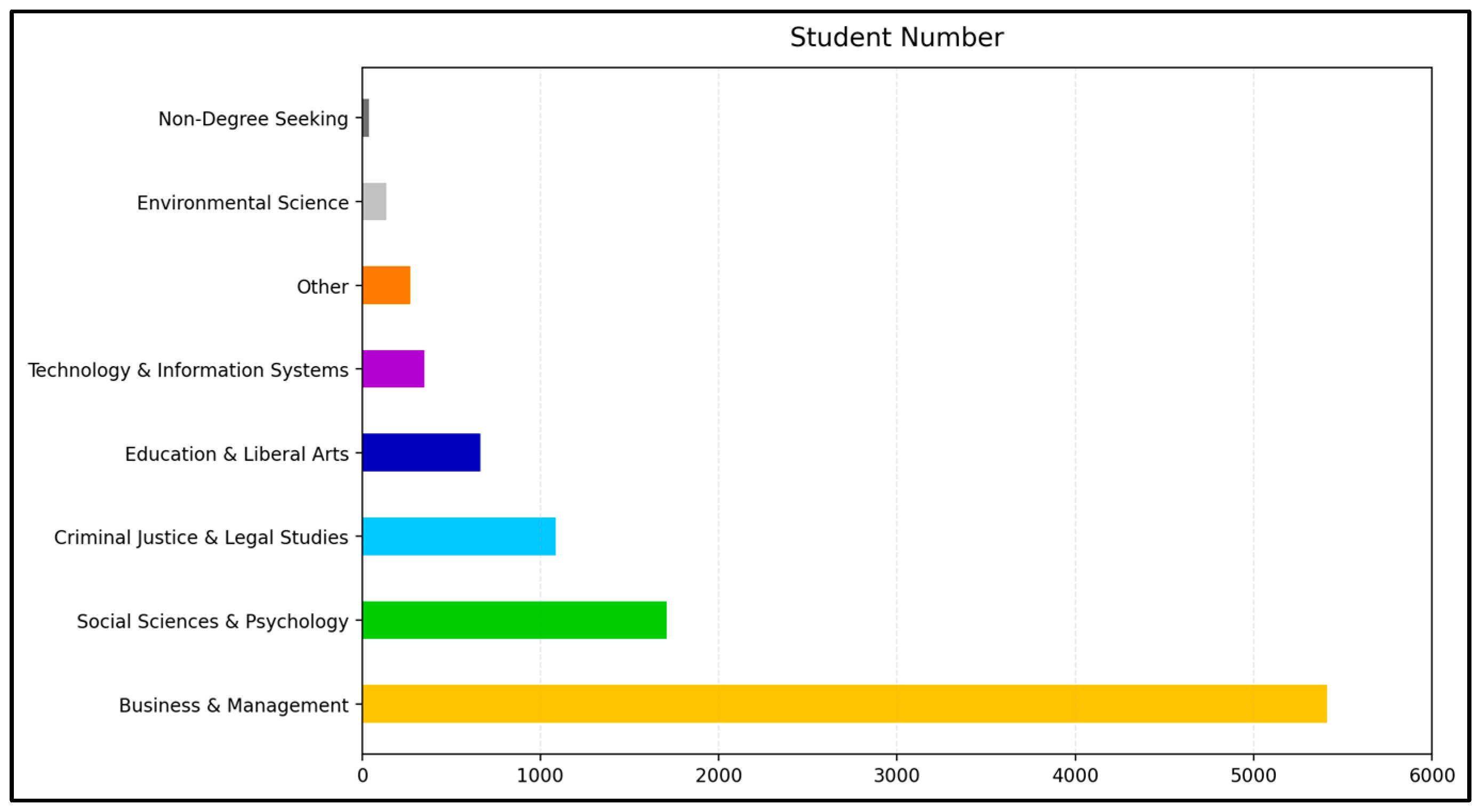
We chose ENV100T: Principles of Environmental Science, a foundational course for novice science students, to transition the anthropomorphic characters into imaginary explorers of the immersive glacial environment. The course introduces Earth’s resources, major spheres (atmosphere, hydrosphere, lithosphere, and cryosphere), and key processes such as disturbance, energy transfer, and biogeochemical cycles (water, nitrogen, and rock). During the study period, 9661 students completed the course, most of whom were enrolled in non-science majors, with business and management representing the largest group (55.99%). Of the STEM majors, technology and information systems (3.62%) and environmental science (1.42%) are a small fraction of the student total population (
Figure 2).
The redesign adopted a storybook format that maintained the anthropomorphism of inanimate earth components. Using Microsoft’s M365 Copilot (Enterprise) (
https://www.microsoft.com/en-us/microsoft-365-copilot) (accessed on 23 November 2025), these characters were transformed into imaginaries of explorers who narrated their experiences, observations, and sense of place. This storybook approach combines anthropomorphic imaginaries with exploration to help students conceptualize complex environmental structures and functions. Exploration serves to develop the learning environment with attributes associated with “search, variation, risk-taking, experimentation, play, flexibility, discovery, innovation,” [
42]. Each chapter follows a narrative arc, where the imaginaries Nico Nitrogen, Remi Rock, and Waverly Water serve as guides in the Instructor Created Content (ICC) delivered through a zyBook platform (
https://www.zybooks.com) (
Table 1). Through illustrative narratives, students journey through nutrients, rock, and water cycles. These stories conceptualize resources, spheres, and cycles within diverse biomes, including coniferous forest, desert, grassland, polar, rainforest, shrubland, temperate deciduous forest, and tundra. Each course run accommodates up to 100 students and is offered every five weeks.
2.2. Waverly Water and the Story of Jökulsárlón: Understanding Glacial Change
For the hydrosphere chapters of the instructional intervention, the anthropomorphized water drop, Waverly Water, guides students through course content. Wavery describes their fictional neighborhood, the Hydrosphere, which is located on Earthtopia. Students learn about streets found in their neighborhood in context with the hydrosphere: Ocean Avenue, Ground Water Way, Glacier Road, River Bend, and Lake Lane (
Table 2). Content found on each street includes the hydrosphere elements and is connected to the associated biomes.
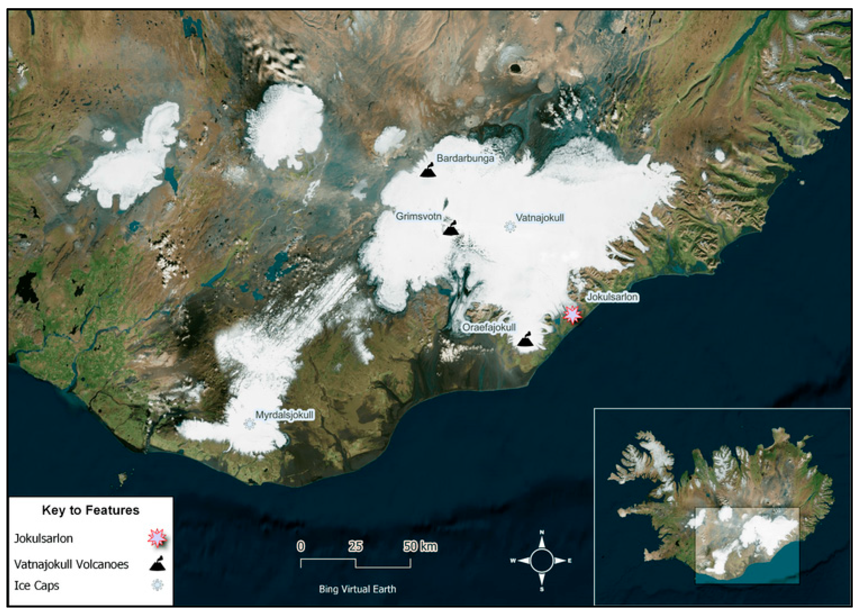
After establishing the routes, we associated the identified biomes with specific course weeks. We embedded VR scenes into the ICC learning activities for those weeks. On the Glacier Water Way route, one stop showcases the cryosphere through the Jökulsárlón glacier proglacial lagoon scene. Jökulsárlón lies in Southeastern Iceland at the lower margin of Vatnajökull National Park (
Figure 1) [
41,
43]. Several outlet glaciers from the Vatnajökull ice cap converge (8100 km
2 in area with 3300 km
3 of ice) converge to feed the lagoon, which is influenced by tides through its connection to the Atlantic Ocean [
44]. The Vatnajökull ice cap is Iceland’s largest and covers three subglacial volcanoes (
Figure 1) [
44]. Over the last century, Jökulsárlón Glacier Lagoon underwent rapid transformation as the Breiðamerkurjökull outlet glacier retreated 5.6 km [
45]. The cascade of geomorphological change includes sustained melting that accelerated the lagoon expansion (1930–2022s). During this time, the lagoon’s surface area increased fourfold, and satellite observations show a continuous rate of expansion of approximately 0.5 km
2 per year [
46,
47]. Surface area increase corresponds to the continuous mass loss at the glacier terminus. With the lagoon’s increased surface area, hydrological connections have changed, influencing tidal exchanges with the Atlantic Ocean. Erosional forces are altering lagoon depth and geometry to be more fjord-like in structure over time [
46,
47]. For the 360-degree imagery, we used the GeoEPIC application to embed a technical view frame of the photo sphere with VR headset capability. The content carries a Creative Commons 4.0 license (CC BY 4.0), allowing educators to share and adapt the material with proper attribution.
This section describes how a VR lesson was integrated into Week 2 zyBook’s learning activity. By linking the GeoEPIC fieldtrip, we used Microsoft’s M365 Copilot AI tool to connect the VR content to the curriculum and adapt Waverly Water as an explorer-themed imaginary. The narrative highlights water’s movement through the Earth’s spheres as part of the hydrological cycle. The design centers on the Jökulsárlón photo sphere featured in Week 2, emphasizing dynamic change in water and its movement. This activity aligns learning theory with the Course Student Learning Outcome and recognizes various Earth processes within the hydrosphere, lithosphere, and atmosphere to support learning goals intended for the student.
Data collection for field notes and imagery took place in the Jökulsárlón glacier area during July of 2019. A GoPro Max 360 camera (
https://gopro.com/en/us/shop/cameras/learn/max/CHDHZ-203-master.html) (accessed on 23 November 2025) was used to collect 360-degree spherical photography. Site-level information and imagery on geomorphology and steam hydrology was collected at this time to develop the GeoEPIC lesson (
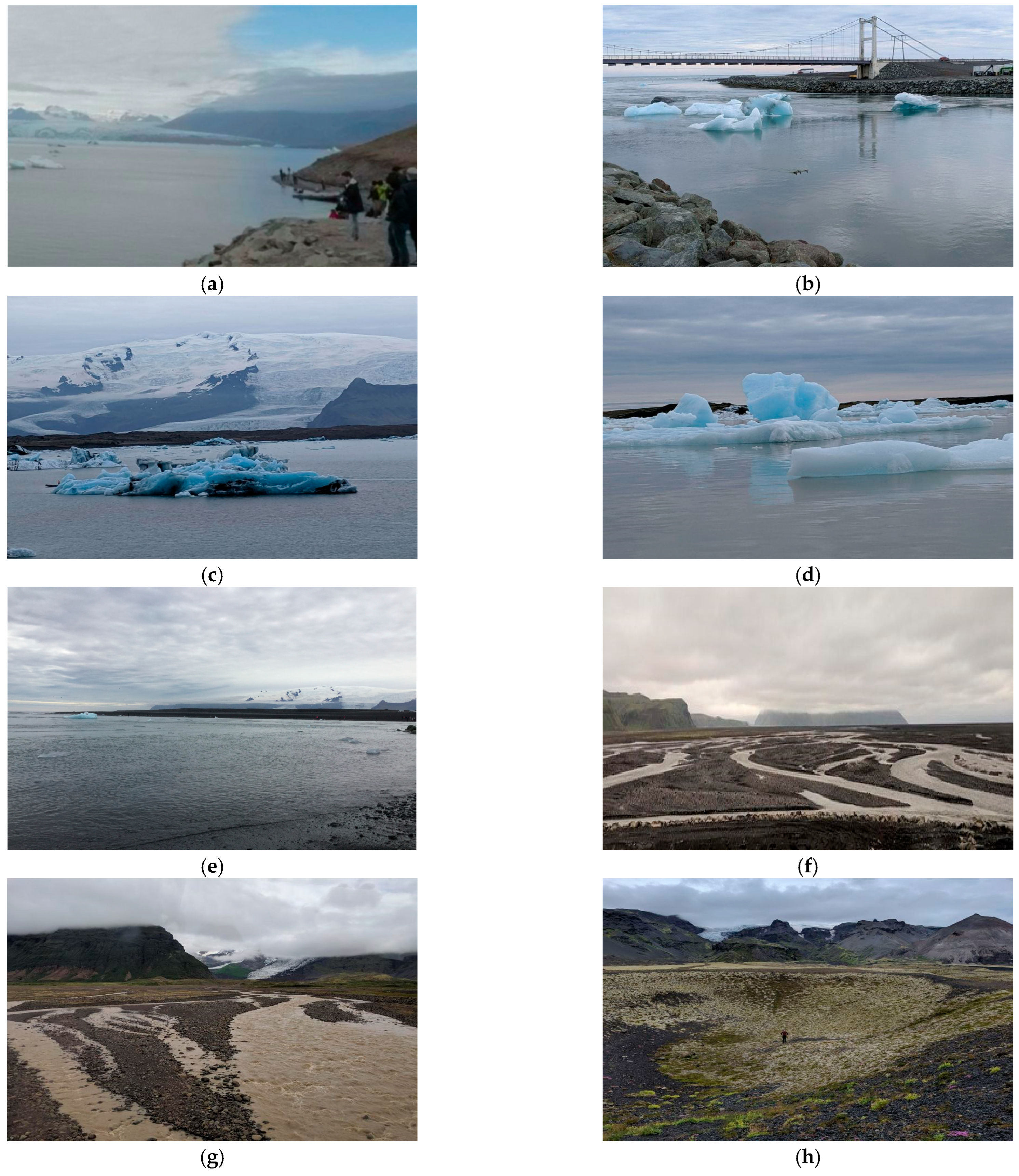
Figure 3a–h).
The images in
Figure 3 are extracted from the associated GeoEPIC lesson and include scenes from the 360-degree photography used in the VR fieldtrip of the Jökulsárlón glacier lagoon and surrounding areas (
Figure 3): (a) Landscape showing the Breiðamerkurjökull outlet glacier tongue interfacing with the proglacial lagoon; the waterline is evident with crevasses and ice cliffs situated just above it, and icebergs are present in the scene [
41]. (b) Bridge spanning Jökulsárlón glacier lagoon with icebergs calved from Breiðamerkurjökull floating towards the outlet to the Atlantic Ocean [
41]. (c) Terminal moraine, glacial till, and Breiðamerkurjökull glacial field merged with Vatnajökull glacier in the background; in the foreground, ice rafting of rock, sediments, and debris on icebergs is evident [
41]. (d) Icebergs displaying glacial blue coloration caused by the Rayleigh effect [
41]. (e) Diamond Beach located in the lower right of the scene with icebergs approaching (image source Niccole V. Cerveny, permission obtained). (f) Outwash plain with glacial streams creating complex array of braided channels [
41]. (g) Meltwater stream rippling showing stream power, transport and deposition [
41]. (h) Drained kettle lake with person at center for scale [
41]. The team examined the landscape scenes and field notes, identified relevant details that support the CSLO, and used the information to guide the narrative design for the contextual application, ensuring conceptual alignment (
Table 3) [
41].
2.3. Humans-in-the-Loop (HITL): A Human-Centered AI Framework for Curriculum Redesign in Environmental Science: Curriculum Redesign and AI Facilitated Transformation (CRAFT)
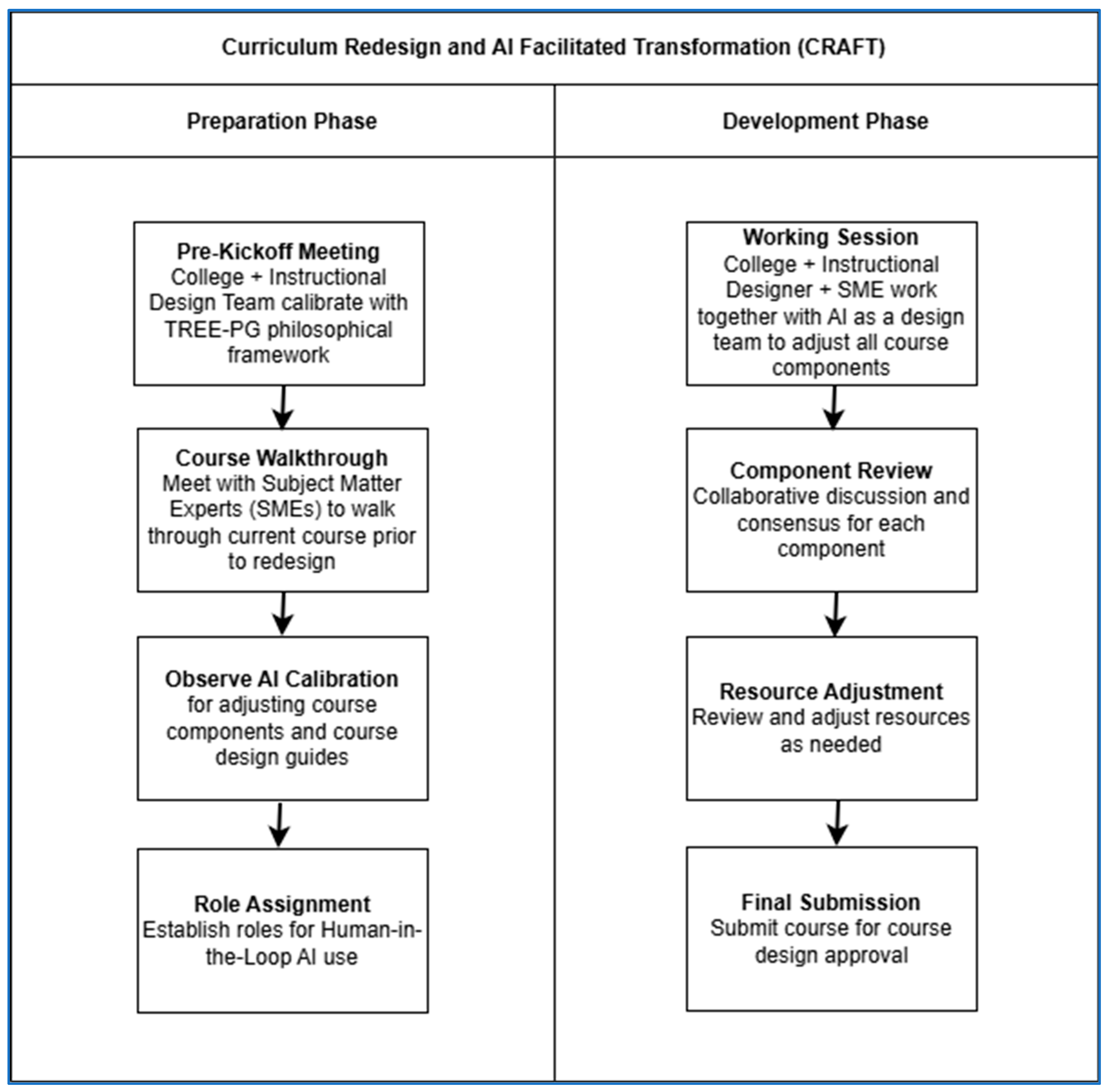
The Environmental Science Program in the College of General Studies adopted a human-centered AI approach for curriculum redesign, involving Subject Matter Experts (SMEs), instructional designers, education theorists, and college leadership. Using a two-phase model called Curriculum Redesign and AI Facilitated Transformation (CRAFT) (
Figure 4), the process begins with the Preparation Phase, where AI is calibrated with the TREE-PG philosophical framework. The education theorist trains the organization-approved AI tool, ChatGPT-4 Enterprise (
https://chatgpt.com/business/) (accessed on 2 December 2025), on the Translating Research in Environmental Education-Physical Geography (TREE-PG) framework [
40]. The team conducts a course walkthrough with SMEs, reviews CSLOs and program-mapped skills associated with the course, and observes AI calibration for resource guide development. Roles for human-in-the-loop (HITL) AI use are then assigned.
In the Development Phase, SMEs, instructional designers, and college leadership collaborate with AI to adjust course components, review resources, and finalize the redesign for approval. Learning theory remains foundational, guiding content creation for asynchronous online learners addressing knowledge-building and barriers to learning [
48]. Multi-modal imagery and narrative rich environments further enhance student reflection and engagement [
49,
50]. The CRAFT model validates these strategies at every step in the redesign process, ensuring appropriate learning theories, VR fieldtrip lessons embedded in zyBooks, and narrative storytelling through anthropomorphic imaginaries effectively supports the student learning experience in the online asynchronous classroom (
Figure 4).
For the development of the instructional intervention regarding the anthropomorphic imaginaries, narrative storytelling, and a virtual reality fieldtrip to the cryosphere with the glacier lagoon stop, considerations of how learning theories apply to each part of the intervention that incorporated the VR fieldtrip required us to use the virtual reality User Interface (VRUI) model (
Table 4) [
40] (p. 62). The VRUI model uses orders to align learning theory to educational content development for Virtual Learning Experience (VLE) architecture. As we embed an immersive VR scene for the Waverly Water field trip, we use the VRUI orders to describe how learning theory is aligned with, and used across, the different course components to develop the zyBook for the class.
For the Core Learning Objectives, we started with the CSLO: Recognize various Earth processes within the hydrosphere, lithosphere, and atmosphere, and identified the learning theories and narrative connections needed to develop the storytelling (
Table 4). For the Core Learning Objectives, we chose the learning theories of social constructivism [
51], conceptual change [
52,
53,
54,
55,
56], systemic functional linguistics [
57,
58,
59,
60,
61,
62], and spatial thinking [
63,
64,
65]. For social constructivism, Waverly Water engages students in learning about the spheres through a shared experience and by relaying their observations through story. The anthropomorphic imaginary processes the information on the cryosphere and hydrological cycle, working with the student in the co-construction of knowledge. For conceptual change, storytelling contextualizes scientific concepts within the environment, providing opportunities for students to reflect on what they know and to revise any misunderstandings they may have about topics, such as glacier retreat and sediment transport. In systemic functional linguistics, Waverly Water’s dialogue becomes part of the learning process, and students share the same discipline vocabulary, aligned with everyday metaphors, to scaffold their understanding of scientific terminology.
The first-order VRUI (Photosphere) design uses sense of place [
66,
67,
68], situated cognition [
69,
70], spatial thinking [
63,
64,
65], and Ludic Pedagogy [
71] (
Table 4). A sense of place helps students experience the immersive cryosphere, no matter their current location. A sense-of-place approach, combined with immersive physical environments, makes abstract topics related to glaciers and meltwater systems more tangible for students. For situated cognition, learning occurs when learning takes place in a realistic context, such as exploring glacial landscapes and water systems through VR, making knowledge practical and meaningful. Regarding spatial thinking, students use multiple perspectives to view the vastness of an ice cap, its outlet glaciers, and margins. These perspectives illustrate scale, distance, patterns, and processes associated with the cryosphere and hydrologic processes. In Ludic Pedagogy, the student, as a fellow explorer with Waverly Water, discovers the glacier environment together through a playful, exciting experience.
For the second-order VRUI (Instructional Intervention), the narrative storytelling and engagement with Waverly Water were grounded in the following learning theories: academic self-concept [
72,
73,
74], social constructivism [
51], experiential learning [
75,
76,
77,
78,
79], situated cognition [
69,
70], systemic functional linguistics [
53,
54,
55,
56,
57,
58], spatial thinking [
63,
64,
65], and Ludic Pedagogy [
71] (
Table 4). Considering academic self-concept, students develop confidence through their interactions with Waverly Water, understanding science through Waverly’s approachable narrative and interactive VR tasks. Positive reinforcement occurs through the completion of the participation activities, which invites students to see themselves as explorers and participants in scientific inquiry. For social constructivism, the anthropomorphic imaginary tells its story as a dialogue to create a shared interpretation of the hydrological process as it moves through the cryosphere with the student. For conceptual change, Waverly Water’s use of familiar metaphors aligned with the science challenge misconceptions about water movement, sediment transport, and deposition. For experiential learning, students take their newly acquired knowledge from exploring the VR immersive environment of the Jökulsárlón proglacial lagoon and use the narrative dialogue to participate in learning activities that support students’ connection of virtual observations to the science associated with outlet and tidewater glaciers, braided streams, and outwash plains. Regarding situated cognition, by exploring problems and interpreting processes within authentic environments, students connect abstract concepts to real-world applications. In systemic functional linguistics, the story and the anthropomorphic imaginary dialogue use clear language to introduce scientific terms in accessible language [
80]. For spatial thinking, observations from the immersive VR environment support learners in analyzing hydrological patterns and processes. Ludic Pedagogy uses fun, imaginative storytelling to make science more engaging. Adding humor and creativity makes the topics easier to understand and gives students an inviting way to learn about the cryosphere.
These pedagogical insights informed the development of the following narrative intervention, “Waverly Water’s adventure in Iceland Visiting Jökulsárlón Glacier Lagoon,” which served as a bridge between conceptual understanding and immersive practice.
“After soaring through clouds and splashing into rivers, Waverly Water felt ready for the next challenge. “I’ve danced in the sky and skipped across mossy beaches,” Waverly said, “but now it’s time to dive deeper!”
Waverly’s droplets shimmered as they flowed toward the Southeastern Coast of Iceland, where the mighty Vatnajökull Icecap loomed in the distance. “Whoa,” Waverly whispered. “That’s the biggest icecap in Iceland. It’s like a frozen crown for the Earth!”
Nestled at the edge of this icy giant was Jökulsárlón, a magical proglacial lagoon where outlet glaciers feed icy waters into the Atlantic Ocean. Waverly joined a stream of meltwater trickling from the glacier’s edge, slipping past braided channels that twisted and turned like a maze. “This is the valley train!” Waverly exclaimed. “It’s like a watery rollercoaster!”
As Waverly flowed through the outwash plain, the stream’s power shifted. At first, it carried gravel and large clasts—rocky bits shaped by the glacier’s grinding journey. “Some of these rocks are smooth and round,” Waverly noticed. “Others are jagged and sharp. It’s like a rock family reunion!”
Further downstream, the water slowed, and sand and silt began to settle. Waverly watched as tiny particles danced beneath the surface, forming ripples and deltas. “We’re painting the Earth with every step,” Waverly said proudly.
Suddenly, a loud crack! echoed through the air. A massive chunk of ice calved from the glacier’s subaqueous terminus, splashing into the lagoon. “That’s an iceberg!” Waverly gasped. “It’s like a frozen mountain taking a swim!”
The lagoon sparkled with glacial blue ice, glowing with a magical hue thanks to something called the Rayleigh Scattering, a trick of light that made Waverly and the other molecules shimmer in shades of blue. “We’re glowing!” Waverly giggled. “It’s like we’re made of starlight!”
But the journey wasn’t all fun and games. Waverly learned that the glacier was retreating, melting faster each year. Sometimes, the melting was so sudden it caused glacial lake outburst floods (GLOFs), sending torrents of water and ice crashing through the lagoon. “We have to be careful,” Waverly said. “Even water can be wild!”
As Waverly floated past kettle lakes—bowl-shaped depressions left behind by melting ice blocks—Waverly felt a sense of awe. “Every puddle, every stream, every cloud…we’re all part of the same story,” Waverly said. “And I’m just one chapter in the great book of Earthtopia.”
With the sun setting over the icy lagoon, Waverly prepared to meet Nico Nitrogen and Remi Rock. “I’ve learned to move, to transform, and to shape the land,” Waverly whispered. “Now, it’s time to learn how energy flows through all living things” [
81].
Finally, for the third-order VRUI (Contextual Application), we use experiential learning [
71,
72,
73,
74,
75], sense of place [
66,
67,
68], and spatial thinking [
63,
64,
65] (
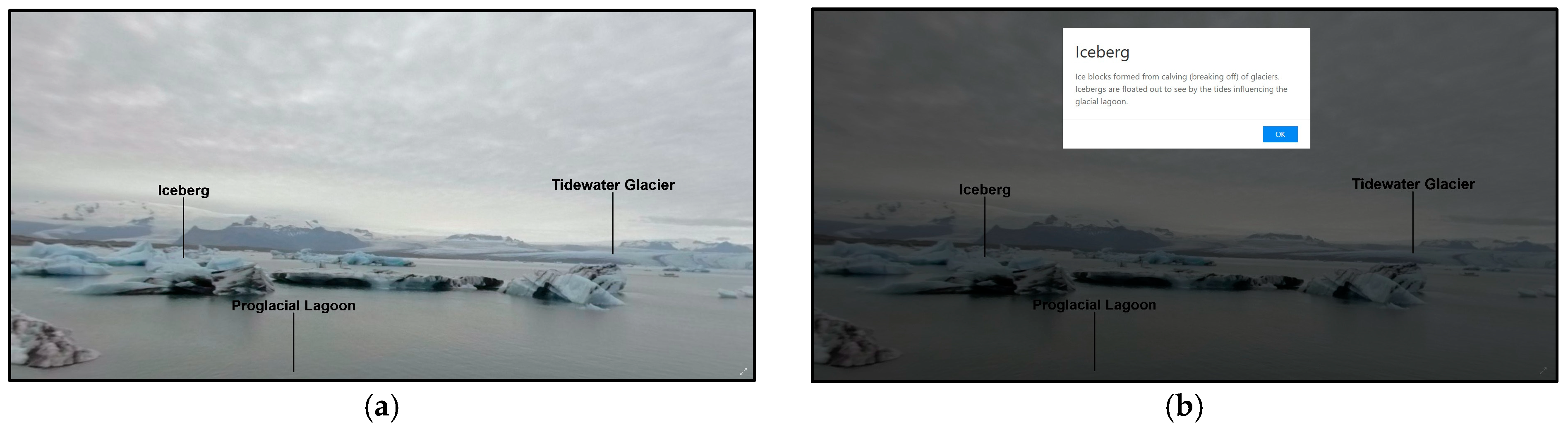
Table 4) when designing the summative assessment. For experiential learning, the summative assessment includes scenario-based questions that ask students to apply what they learned in the VR experience and story to explain the science behind Waverly Water’s journey. To create a sense of place, the summative assessment questions reference authentic physical features in the virtual location (
Figure 5), allowing students to demonstrate their understanding of the environment. For spatial thinking, students analyze interconnected processes in the cryosphere and can synthesize these relationships (for example, how a melting glacier affects hydrology or creates natural hazards). Students use their interpretation of the immersive visual environment and its associated story to reason through the dynamic feature patterns and the associated processes of cryosphere dynamics [
82]. The resulting narrative was embedded into the zyBook alongside the technical frame with VR headset capability. The narrative is featured below [
81].