Article

Assessment of Erosion in the Urban Coastal Areas of Al-Batinah and Its Implications for Sustainable Tourism


by
Mohammed Siddique
1,*,
Venkoba Rao
2 and
Ammar Abdulrahman Al Balushi
2
1
Faculty of Information Technology, Majan University College, Muscat 710, Oman
2
Faculty of Business Management, Majan University College, Muscat 710, Oman
*
Author to whom correspondence should be addressed.
Coasts 2026, 6(3), 31; https://doi.org/10.3390/coasts6030031
Submission received: 23 April 2026 / Revised: 1 June 2026 / Accepted: 15 July 2026 / Published: 24 July 2026

Highlights

What are the main findings?
  • The research study confirms the higher reliability of satellite image classification with the RF and SVM models, achieving an average of overall accuracy of 97.7% over the years, along with a meta-analysis-based validation indicating a consistently significant variation in water encroachment.
  • There is a significant increase in water area in the Al-Batinah region, from 2.99% in 2017 to 12.36% in 2025, confirming a systematic change in water level due to flash floods and sea-water flooding; this is largely attributed to water-related changes and could partially be attributed to coastal erosion.
What are the implications of the main findings?
  • It is necessary for policymakers to prioritize revising land-use policies for urban management and initiate an engineering intervention to mitigate the risks of water encroachment. This is necessary to ensure vulnerable coastal communities are protected and to boost tourism in the urban coastal region.
  • The development of a resilient and sustainable infrastructure is critical for the long-term viability of the tourism destinations of highly populated coastal regions of Oman, and aligns with “Oman Vision 2040”. This will enable the promotion of regenerative tourism while also enhancing ecosystems, thus contributing to sustainability.

Abstract

The tourism sector in the Sultanate of Oman is central to “Oman Vision 2040”, with a strategic focus of the government on its dynamic transformation. Coastal regions, vital to tourism, are affected by changes to the coastline due to flash floods, sea-water flooding, and erosion. Despite its implications for tourism and the economy, this topic remains relatively under-explored, especially as to use of Sentinel-1 satellite images. This study assesses water-level changes due to erosion in the urban coastal region of the Al-Batinah governorate via land cover classification. Using the Support Vector Machine (SVM) classification technique, the overall accuracy is found to be 97.7% and the Kappa coefficient value for the year 2018 is 1.0. Although, when using the Random Forest (RF) classification technique, the accuracy is nearly identical, there is varying precision for the water area. A critical observation is made, showing significant increase of the water area from 2.99% in the year 2017 to 12.36% in the year 2025, suggesting water encroachment. With fixed-effect and combined-effect size meta-analysis models, the confidence levels were identified as 95.0% and 0.37, respectively, indicating a consistent variation in water area that supports the outcomes of image classification. This study offers a valuable insight for policymakers as to managing coastal regions, along with providing assistance to vulnerable coastal communities. The study focuses on a particular governorate, given the satellite images, whereas a broader regional comparison would address the limitation of the generalizability of results. In the future, the research could integrate surveys from coastal communities and businesses for a comprehensive qualitative data perspective on the region’s tourism sector.

1. Introduction

The Sultanate of Oman is becoming a popular tourism destination, with various initiatives by the government aimed at integrating tourists into the social and cultural fabric of the country [1]. Tourism in Oman is among the five economic sectors identified by Tanfeedh as driving economic diversification [2]. Departing from its heavy reliance on hydrocarbons and aligning with its Vision 2040, Oman’s economy is explicitly diversifying to other areas such as tourism, harnessing its tremendous potential to increase its Gross Domestic Product (GDP), providing employment opportunities, and promoting development of its economy [3,4]. As highlighted in the National Tourism Strategy 2040, tourism is central to Oman’s economic development [5]. With various UNESCO World Heritage sites as well as other fascinating tourist hotspots, it attracts numerous tourists every year [6]. Oman witnessed an upward trend and recovered as a regional tourism destination post the economic stagnation following the COVID-19 pandemic and falling oil prices [7]. Abdelfattah et al. (2023) found that the tourism sector is significantly influenced by the government policies and significantly fueled by community participation and smart tourism infrastructure [8].
Within the tourism sector, coastal tourism, such as the activities and experiences that happen in coastal regions with a broad range of activities from beach recreation to cruising and water sports, represents a key component [9]. Thanks to its highly strategic geographic position, Oman has a vast 3165-km coastline. Interestingly, this long stretch has three distinct shorelines, including the Persian Gulf/Strait of Hormuz, Arabian Sea and the Gulf of Oman, with different bodies of water and featuring varied geographical characteristics. Oman is transforming its huge coastal line with focus on all the strategic sectors including tourism [10]. Undoubtedly, coasts are the most attractive places for tourists when choosing a tourist destination [11]. The coastline has long been a magnet for tourists and has become synonymous with tourism. These coastal areas have the dual mandate of conserving natural resources and providing opportunities for recreation and tourism. [12]. Smith et al. (2023) critiqued the dominant view of tourism as a panacea for coastal futures, reflecting that analysis showed both positive and negative sentiment towards the impacts of tourism [13]. Coastal areas are popular tourist destinations and face rapid urbanization partly resulting from tourism development [14]. Sustainable tourism must maintain a high level of customer satisfaction, raise awareness of sustainability concerns, and spread sustainable tourism practices among them. Promoting sustainable tourism in this setting is a significant task for the global community, especially for nations with abundant natural resources. Despite the tourist-friendly nature of coastal attractions, they are fraught with significant challenges such as coastal erosion leading to the disappearance of the beach, which can impact tourism and major infrastructure [15]. Coastal erosion refers to the recession of parts of the coastline that might occur due to various short- and long-term natural events. However, over the past century, human activities emerged as one of the significant contributors to erosion [16]. Al Ruheili and Boluwade (2023) felt that it is vital to assess human influences on coastal ecosystems in the sustainability of coastal ecosystems [17].
Further, coastal ronments exist along a spectrum from sustainable to unsustainable, which will have huge and varied implications for tourism [18]. The United Nations Sustainable Development Goals (UNSDGs) emphasize the protection of coastal ecosystems, the people living in these areas and their resources. Moussa et al. (2024) recognized that tourists are increasingly prioritizing sustainability and meaningful experiences in their tourism activities [19]. Biladi (2021) opines that sustainable development of tourism in Oman has drawn the keen attention of researchers, academicians, and professionals [20].
This study assesses the extent of water-level changes, along with considering coastal erosion in the Al Batinah governorate—one of the popular destinations in Oman. The Al-Batinah governorate, situated at the foothills of Western Hajar Mountains (WHM), is split into the North and South governorates, and has a coastline of 275 km [21,22]. Sohar, Al Suwaiq, Al Khabura, Al Saham, Shinas and Liwa are part of the North wilayahs while Al Barka, and Al Musanna are in the South wilayahs. Historically, the Al-Batinah plain on the Sea of Oman is highly prone to extreme cyclonic events, rises in sea levels and storm surges. Due to its sedimentary nature, and the occurrences of flash floods and sea water flooding, it is also vulnerable to coastal erosion. The erosion rate on average between the year 2017 and 2020 was observed to be 9 m/year [23]. Hereher et al. (2020) [24] explored the vulnerability of Omani coastal zones and found that the Al-Batinah plain is one of its highly susceptible coastal regions. Further, with frequent exposure to tropical cyclones, inundation is inevitable [24]. Thus, Al-Batinah, which has both high concentrations of population, infrastructure and services and significant low-lying lands, is at a greater risk. Aggressive urbanization and over-extraction of resources have significantly affected the coastal ecosystems in the Al-Batinah coastal region [25]. Considering that the Al-Batinah coastal plains with interior wadis are the most fertile strip supporting Oman’s agricultural activities, its preservation is of prime importance to Oman’s economy [26]. Al-Batinah is also identified as an important region for infrastructure development and for managing heritage sites promoting tourism experience [27]. The presence of heritage tourism indicates that there is a need to preserve authentic cultural landscapes along with the enhancement and promotion of tourism infrastructure [28].
Thus, with the dynamic nature of Oman’s coastal region and the momentum on sustainability in recent years, it is imperative to have a comprehensive temporal and spatial evaluation of its coastline to understand its evolution, current state and future implications [21,29]. Tools such as spatially explicit image processing and the Geographic Information System (GIS) can help monitor environmental impact in the region, and support sustainable tourism planning [28]. Moreover, as rightly highlighted by Chen et al. (2023) [30], one of the motivations for this study is to increase public awareness of environmental protection and promote sustainable development by contributing to research on coastal ecosystems Chen et al. (2023) [30]. While the research study does not quantify the shoreline retreat, the changes in water coverage in Oman are heavy influenced by the climate changes in the Persian Gulf [31]. The larger coastal region of Oman has experienced an increased intensity of cyclones with severe flash floods and sea water changes, such as those experienced in Gonu and Asna [32]. The findings are based on remote sensing data, and focus on climate-driven flooding, identifying water-level variations and potential impacts on tourism in the region.

2. Literature Review

2.1. Tourism Growth and Unintended Consequences

Oman’s tourism has been extensively recognized as a strategic move towards economic diversification that contributes to the overall GDP growth, employment levels and infrastructure development [33]. Across the globe, a rise in transport technology coupled with growing prosperity has led to an exponential increase in coastal tourism at the start of the 21st century [34]. Oman is no exception. Further, community-driven tourism has resulted in substantial growth. However, this became an exacerbator of difficulties in coastal areas, resulting in unintended consequences. Evaluating the impacts of tourism on social, cultural, economic and environmental domains, Smith et al. (2023) found that the positive economic benefits were overshadowed by negative local environmental and social impacts [13]. The historical shifts in the land cover discovered using satellite images provide insights on changes in urban and vegetation covers due to water area expansions and help to preserve coastal areas, contributing towards sustainable management [35].

2.2. Coastal Areas and Erosion

Historically, coastal areas are used for recreation, transportation, human settlement, industry, agriculture, and as a potential source of wave and tidal energy [36]. Coastal areas are highly dynamic environments and are vital not only for biodiversity, as they provide a habitat for many species of plants and animals and breeding and nesting sites for marine life, but also for economic activities comprising tourism, fishing, agriculture, shipping, algae farming, and urban development [37]. Coastal erosion is a critical environmental challenge affecting shorelines worldwide and researchers have been studying various shoreline change metrics for effective coastal management, which impacts livelihood adaptation, economic development, and even tourism promotion [38]. Quijada et al. (2025) highlight that globally, approximately 60% of beaches are experiencing erosion attributed to factors such as sea level rise, reduced sediment supply, human activity, and extreme events such as storms [39]. Beaches which are key to tourism development are heavily impacted by coastal erosion [40].
Climate change significantly increases storm activity and rises in sea level leading to beach erosion [41]. In fact, it significantly alters the ocean environment, resulting in coastal erosion and negatively reshaping the coastline [42]. This natural process of erosion endangers ecosystems, disrupts local economies, and threatens the livelihoods of millions of coastal residents [43]. When tourism is a critical variable, this erosion is a huge threat to the growth of coastal economies [44]. Reduced landscape quality and beach access and width will enormously affect tourism [45]. Thinh et al. (2019) state that instances of coastal erosion have a profound effect on the tourism attraction, which is a major challenge for various governments in understanding this relationship [46].
A systematic review highlighted the dire state of coastal erosion and morphological shifts in West Africa, and emphasized the gap between available scientific research and regional policies that is critical for a sustainable coastal protection [47]. Cruz-Ramírez et al. (2024) synthesized the essential conditions and multi-disciplinary indicators that are required to assess the vulnerability through a framework that provides a structured pathway to develop pro-active local risk mitigation strategies for coastal governance [48]. A comprehensive retrospective analysis of the global evolution of ocean and coastal management was performed that illustrated changes in policies historically and lessons learned that influenced climate-resilient frameworks [30].

2.3. Oman’s Approach

Oman took up a multifaceted approach to protect its coastal regions, integrating coastal management as a strategy, and initiated nature reserves, balancing growth and environmental conservation [19]. One of the most common indices for evaluating the vulnerability in the coastal areas to changes in rise of sea level and climate is the Coastal Vulnerability Index (CVI) [49,50]. By countering various domestic and global challenges such as pollution, climate-induced stressors and overfishing, Oman, like its counterparts in the Gulf Cooperation Council (GCC), has embraced the “Blue Economy”, guiding it towards sustainable utilization of its seas and coastal resources to improvise the livelihoods of its people, economy and ecosystem [51].

2.4. Monitoring Coastal Regions

The Sultanate of Oman’s unique and vast coastal regions require careful spatial planning in the work towards sustainability [20]. The topographic evolution of the coastal regions in Oman is an important part of its tourism infrastructure. Erosion of coasts and beaches and changing shorelines require systematic and scientific efforts to combat the negative impacts. Since 2004, researchers have utilized remote sensing and GIS techniques to source and analyze shoreline change and erosion [47]. Quantitative monitoring of coastal changes is crucial as it helps identify rates of erosion and pinpoint hotspots that require attention [52]. Satellite imaging is frequently employed to analyze coastal monitoring and analysis, including erosion prediction. Chawalit et al. (2025) stress that ground surveys and remote sensing technology are two popular methods for monitoring coastal erosion [43]. The satellite remote sensing methodology with earth observation techniques is used to monitor, quantify and evaluate coastal accretion and erosion patterns. This can further be correlated with the physical changes to analyze the socio-economic implications for tourism infrastructure. The Synthetic Aperture Radar (SAR) sensors are capable of penetrating clouds to acquire images irrespective of the weather conditions. This is due to the sensors’ ability to operate independently of solar radiation and for longer durations [53]. The Copernicus Sentinel Satellite program for earth observation is excellent in acquiring high temporal-resolution data. The ML techniques such as RF, SVM and Convolutional Neural Network (CNN) leverage high-resolution satellite imagery that could be utilized in evaluating the coastal dynamics and land-use transitions.
The plain of the Al-Batinah coastal region is bordered by the Sea of Oman and WHM. The Al-Batinah coastal plains with interior wadis comprise the most fertile strip of land, supporting Oman’s agricultural activities [26]. Furthermore, the findings reveal that the spatially explicit image processing and Geographic Information System (GIS) tools play a critical role in identifying suitable tourism development regions, monitoring environmental impact in these regions, and supporting sustainable tourism infrastructure planning. Al-Awadhi et al. (2022) noted the resources subject to extraction and determined that reckless construction at Al-Batinah resulted in tremendous stress on its coastal ecosystem [25]. A key factor for political and cultural identity is the promotion of community-driven tourism. For sustainable tourism development, this can be achieved by stakeholder participation [54].
The land use and land cover (LULC) mapping can be refined with higher accuracy using Sentinel satellite image processing. Recent progress involves high-resolution Sentinel-2 optical data combined with the Sentinel-1 bands, addressing limitations and individually focusing on an enhanced feature extraction [55]. The object-based image analysis (OBIA) and graph-building techniques allow segmentation of spatially coherent objects, reducing noise significantly [56]. Digital Elevation Model (DEM) evaluation process has improved, in which ML algorithms can now combine the InSAR data with the satellite Unmanned Aerial Vehicle (UAV) photogrammetry, ensuring accurate determination of altitudinal errors in both arid and flat terrains [57]. Furthermore, the vector-based auxiliary features add water and urban regions, providing critical contextual data [58]. These enhancements are considered essential for representing diverse land covers [59].

3. Study Region and Satellite Images

3.1. Study Region

The primary location of study is the urban coastal area of the Al-Batinah region (latitude: 23.5° N, longitude: 57.5° N) as shown in Figure 1, covering approximately 12,500 km2. The rich primeval maritime landscape and rich heritage sites in the region are considered to be a vital corridor for the Sultanate of Oman’s tourism industry. It is characterized by an arid agro-climatic zone, a characterization that is particularly significant for its high-end resorts, leisure, and traditional fishing villages that are vital for the achievement of “Oman Vision 2040”.
The Al-Batinah region, due to its low-lying topography, is highly vulnerable to soil erosion and flash floods from the Al-Hajar mountain, disrupting travel networks, as well as sea-water flooding, which damages the structural integrity of coastal landmarks. Hence, the area is considered vital for this study on damage assessment and the evaluation of tourism regions in the country.

3.2. Satellite Images Utilized

The Sentinel-1’s satellite images, as shown in Table 1, were acquired from the Copernicus Data Hub for the duration between April 2017 and April 2025 to classify land cover and detect changes [59]. The geospatial Ground Range Detected (GRD) data products consist of a higher resolution of 10 m × 10 m based on the Interferometric Wide Swath mode. They are visualized using VV polarization, and are fully compatible with remote sensing software applications such as ESA Sentinel Application Platform (SNAP) version 13.0.0 and ENVI version 5.0 tools.

4. Methodology

The research methodology consists of the processing of Sentinel images, along with the implementation of ML algorithms. The supervised ML Random Forest (RF) and Support Vector Machine (SVM) classification models have been selected for categorizing Sentinel images into four classes. These classes consist of water, bare soil, vegetation, and urban land covers. Further, the outcomes from the changes detected are systematically analyzed and evaluated to determine the impacts on the region’s landscape and implications for the tourism sector.

4.1. Sentinel Image Pre-Processing

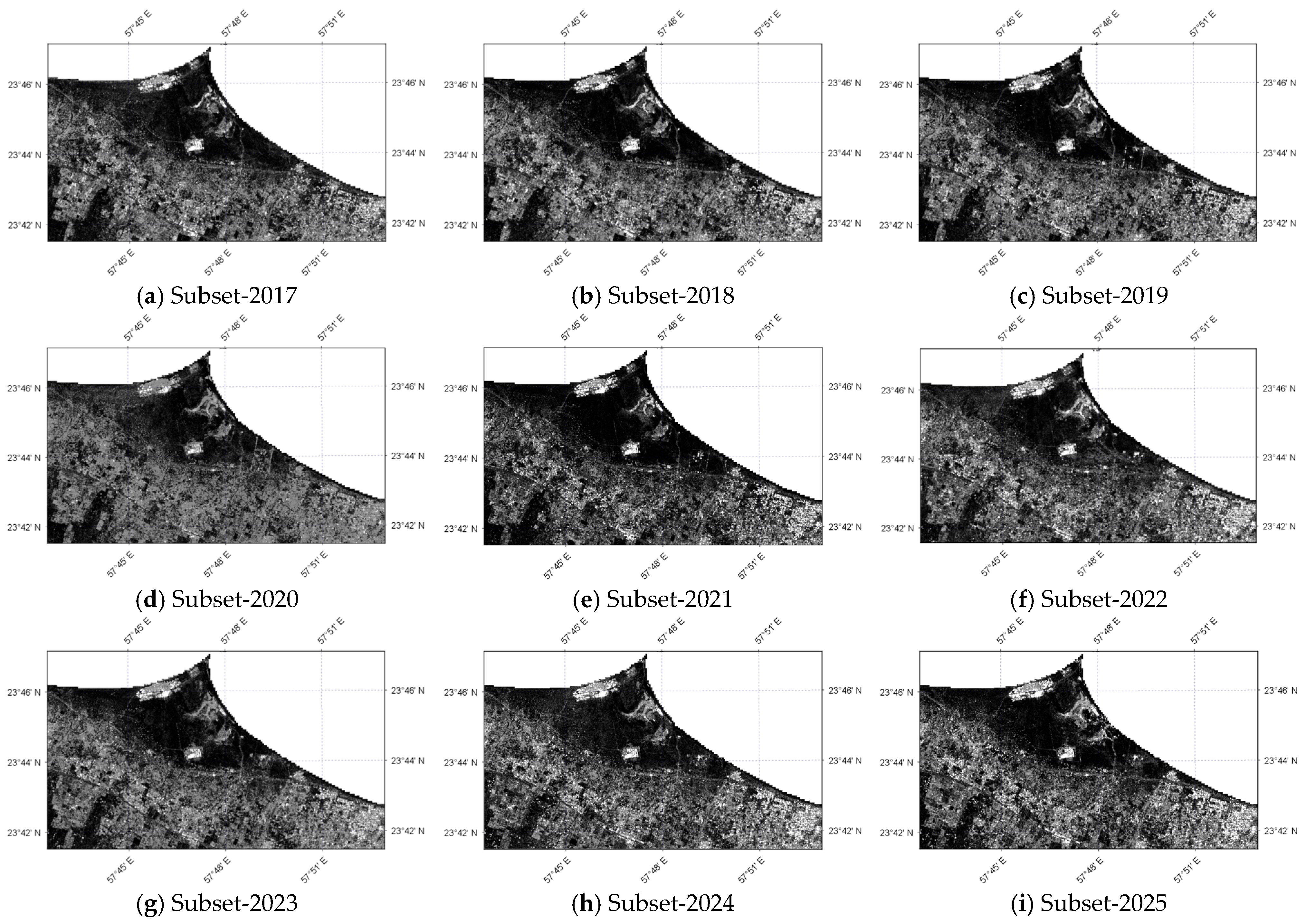
The classification of Sentinel images requires extracting subsets from the dataset along with specific geographical coordinates. Once these subsets are extracted, they are processed for clear interpretation using image classification tools. The below Figure 2 consists of subsets of images for the Al-Batinah region for the years 2017 to 2025.
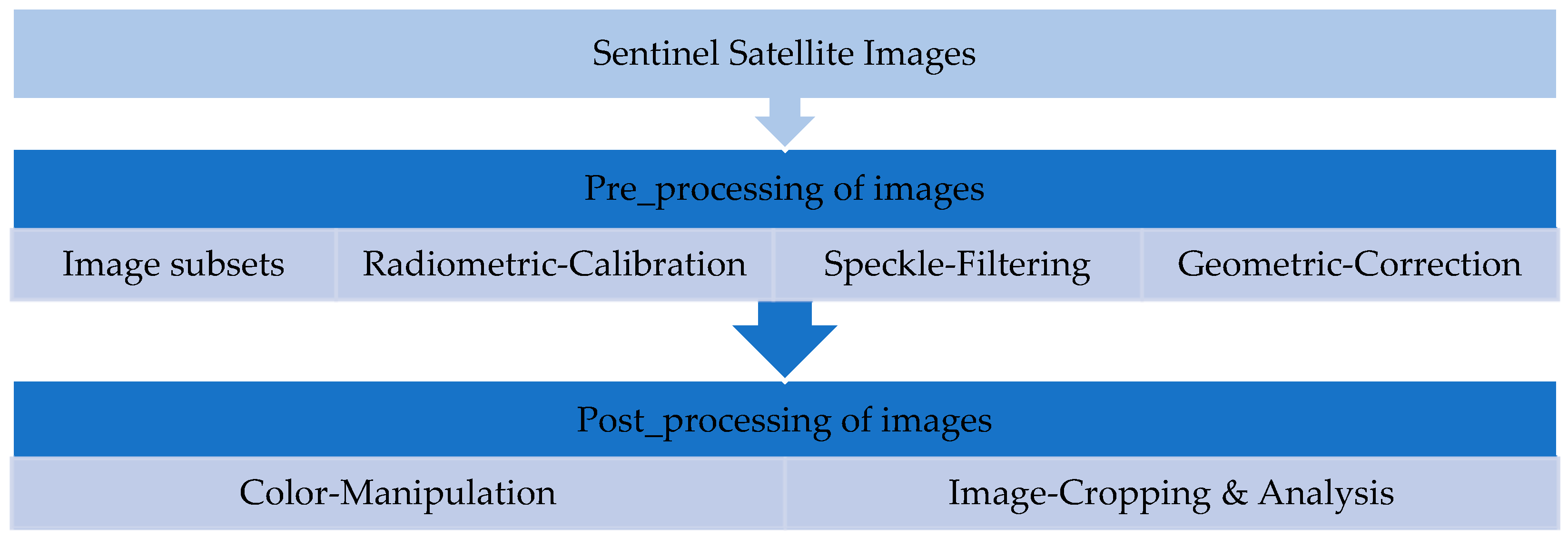
The subsets of Sentinel satellite images require refinement through pre-processing and post-processing for accurate geographical interpretation. The pre-processing stage includes applying radiometric calibration, speckle filtering and geometric corrections. Once the images are classified, the post-processing is performed for corrections through color manipulation and image cropping. Further, these images are analyzed for clear segregation of the various types of land cover. The below Figure 3 outlines the workflow involved in classifying the Sentinel images.
RF model-based performance on multi-spectral satellite images using diverse features as well as spatial resolution was explored by Akar and Güngör [61]. In terms of an important score, this model classifies images with feature prediction capability by using the prediction function f x , Formula (1).
f x = D f u l l + k = 1 K C o n t r i b u t i o n   ( x , k ) ,
Here, the D f u l l represents the datasets and k represents the feature count. Using the implementation of the CCD-Conv1D change detection method, the resultant classified Sentinel satellite images provided a clear land cover determination with particular distinction of inundations in the regions with vegetation [62].

4.2. Incorporating the Tidal Correction

The coastline of the Al-Batinah urban coastal region consists of a mixed semi-diurnal tidal trend, which during spring reaches a range of roughly 2.1 m. This is in reference to the national hydrographic data based on Muscat port and the Minal Al-Fahal coastal station that utilizes the global finite element solution (FES) model [10]. To eliminate the horizontal discrepancies occurring due to this tidal change, all extracted shorelines along the coast were corrected into a standardized vertical datum [63]. The acquisition timestamps of all satellite images that were acquired for the spring of each year were extracted from the metadata. Based on the FES2014 model, the tidal residual signal detection using altimetry is reliable [64]. The historical tide tables from the Muscat and Minal Al-Fahal port were cross-verified referencing the Mean Sea Level (MSL). Since the coastal area features a low-gradient sandy profile, the shorelines were horizontally translated to the MSL datum using Equation (2).
x = h t i d e h M S L t a n   β
where h t i d e is the tidal level during the time of satellite image acquisition, h M S L is the reference datum and t a n   β is the local coastline gradient. The slope value β was derived using the multi-temporal topographic profile as well as the standard regional coastline topography of approximately ~2–5°.

4.3. Machine Learning-Based Classification Strategy

A systematic classification of the Sentinel images in the coastal region of Al-Batinah was performed to identify change patterns in land cover. The coastal features were categorized to analyze the increases in water areas affecting the bare soil region, using ML algorithms. Further, the classified images were contrast-stretched for clarity and the outcomes were evaluated to determine consistency and reliability. A supervised ML-based RF classification algorithm was selected to classify the Sentinel images into four categories. To assess the classification accuracy across all datasets, various evaluation metrics using a confusion matrix have been used, a tactic which supports the evidence-based land cover assessment of coastal regions. Furthermore, a pair-wise temporal validation approach has been adopted to validate the result’s accuracy. Here, two consecutive years are grouped into overlapping pairs to enable consistent comparative analysis. This sequential pairing is repeated across all years to ensure a comprehensive validation is performed. The water area percentage identified for each year is considered as a group value, respectively, and effect sizes have been calculated using Equation (3).
C o h e n s   d = ( X 2 X 1 ) σ g l o b a l ,
where X 1 represents water-class percentage for the selected year and X 2 represents the water-class percentage of later years. By considering a pair of these years as a two-point sample, the global standard deviation (SD) is calculated using Equation (4).
σ g l o b a l = i = 1 n ( X i X _ ) 2 n ,
where σ g l o b a l is the global SD and n = 1 per group, serving as a stable and consistent denominator to compare each pair’s effect size, a factor that represents the overall variability of the dataset. Using a meta-essential technique, the fixed-effect and publication-bias analysis have been performed to confirm the confidence in terms of the accuracy and reliability of the achieved outcomes [65].

4.4. Limitations

It is acknowledged that the Sentinel-1 GRD VV polarization with specific classification uncertainties cannot be solely relied upon, since the SAR backscatter is sensitive to temporary tidal flooding and wind-driven surface roughness, as well as the changes in the seasonal soil moisture. Therefore, the localized expansion of the water class could only capture the transient inundation instead of the permanent geomorphic erosion. These areas are interpreted as high-frequency coastal inundation zones indicative of structural vulnerability along the Al-Batinah region, rather than definitively mapped to definitive long-term erosion or shoreline retreat. Further, this research contributes in detecting changes in water area and potential implications in promoting tourism in the region.

5. Results and Analysis

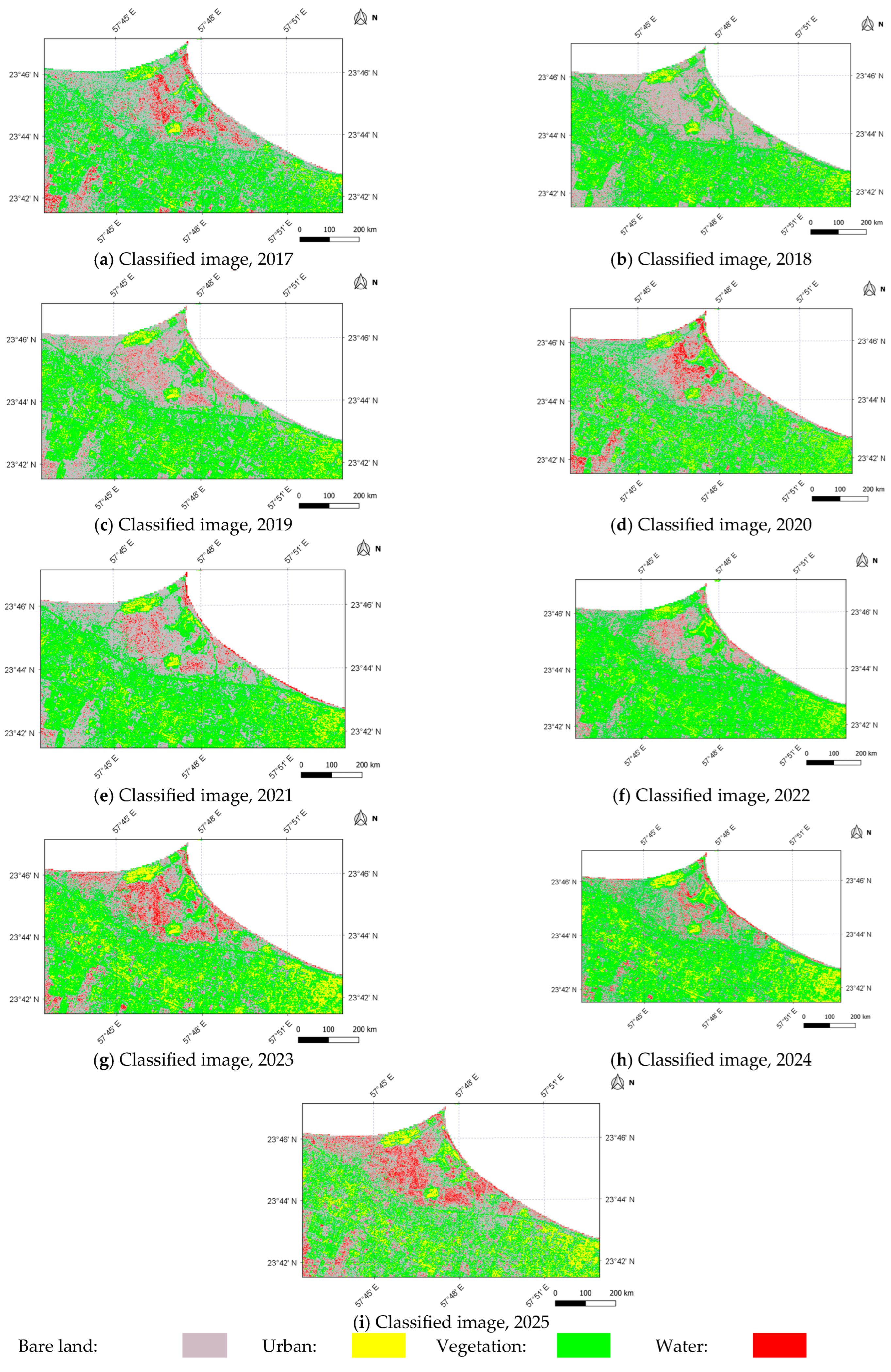
The land cover distribution for the larger Al-Batinah urban coastal region is categorized into water, bare land, urban, and vegetation. The per-year sample sizes of this study, with samples from the years 2017 to 2025, were between 7731 and 8558, respectively. The supervised RF classification techniques were performed on these land cover segments, and generated all four types of classes through cross-validation outcomes. This is depicted in Figure 4, below. The comparative analysis for these segments included accuracy, correlation, error rates and precision; these values were recorded.
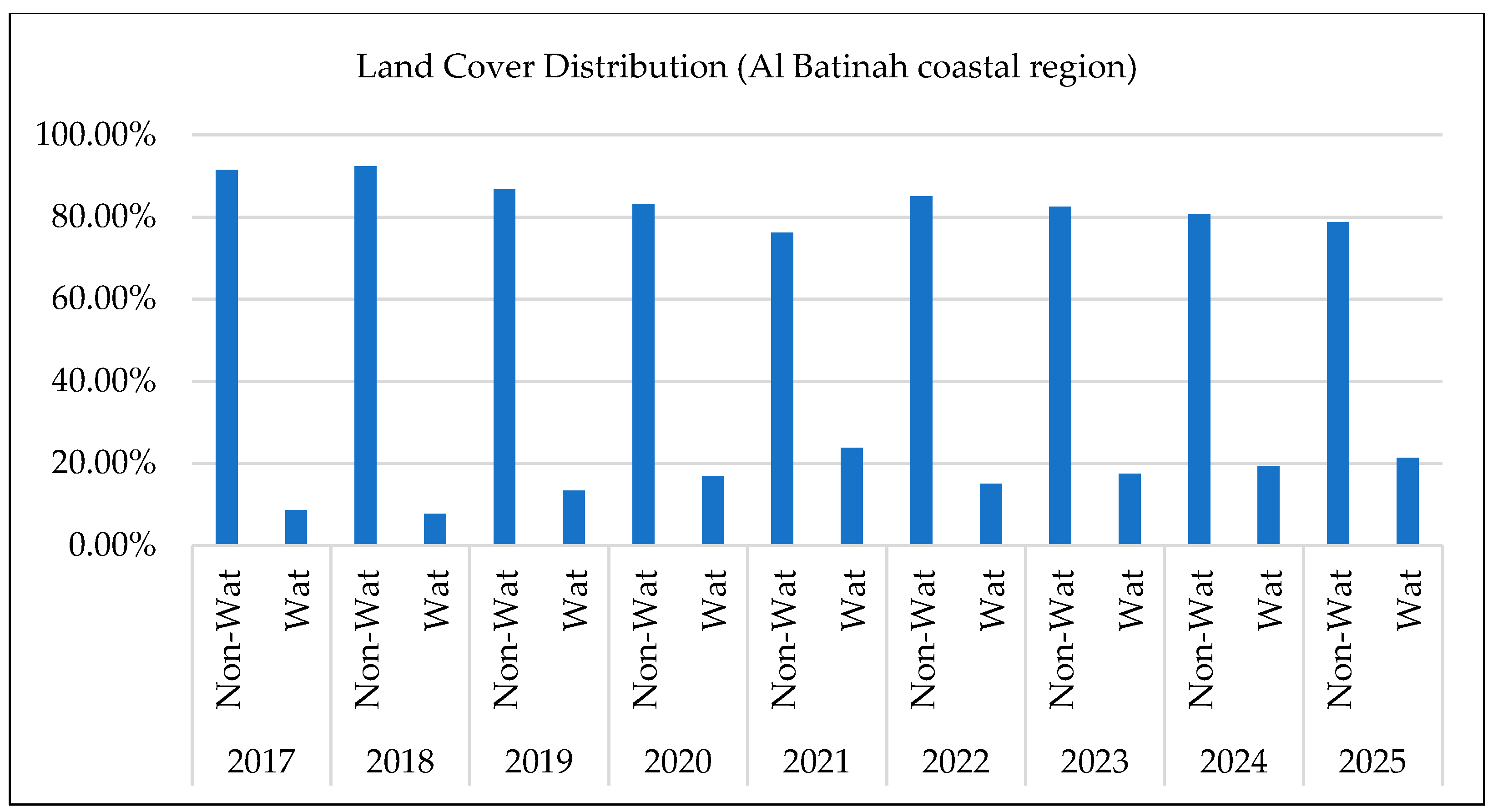
From the results, it is evident that the water area constituted 12.36% in the year 2025, spread over vegetation and urban regions of the south Al-Batinah region. The average accuracy from the land cover distribution process as identified through the RF algorithm was found to be 0.9. As observed in Figure 5, the water (W) and non-water (Non-W) area changes in the South Al-Batinah region, using RF based classification techniques, depict an increasing trend in changes in water regions during the 2017–2025 period. Particularly, these changes provide a deeper insight on a critical concern as to the expansion of water bodies in the coastal area.
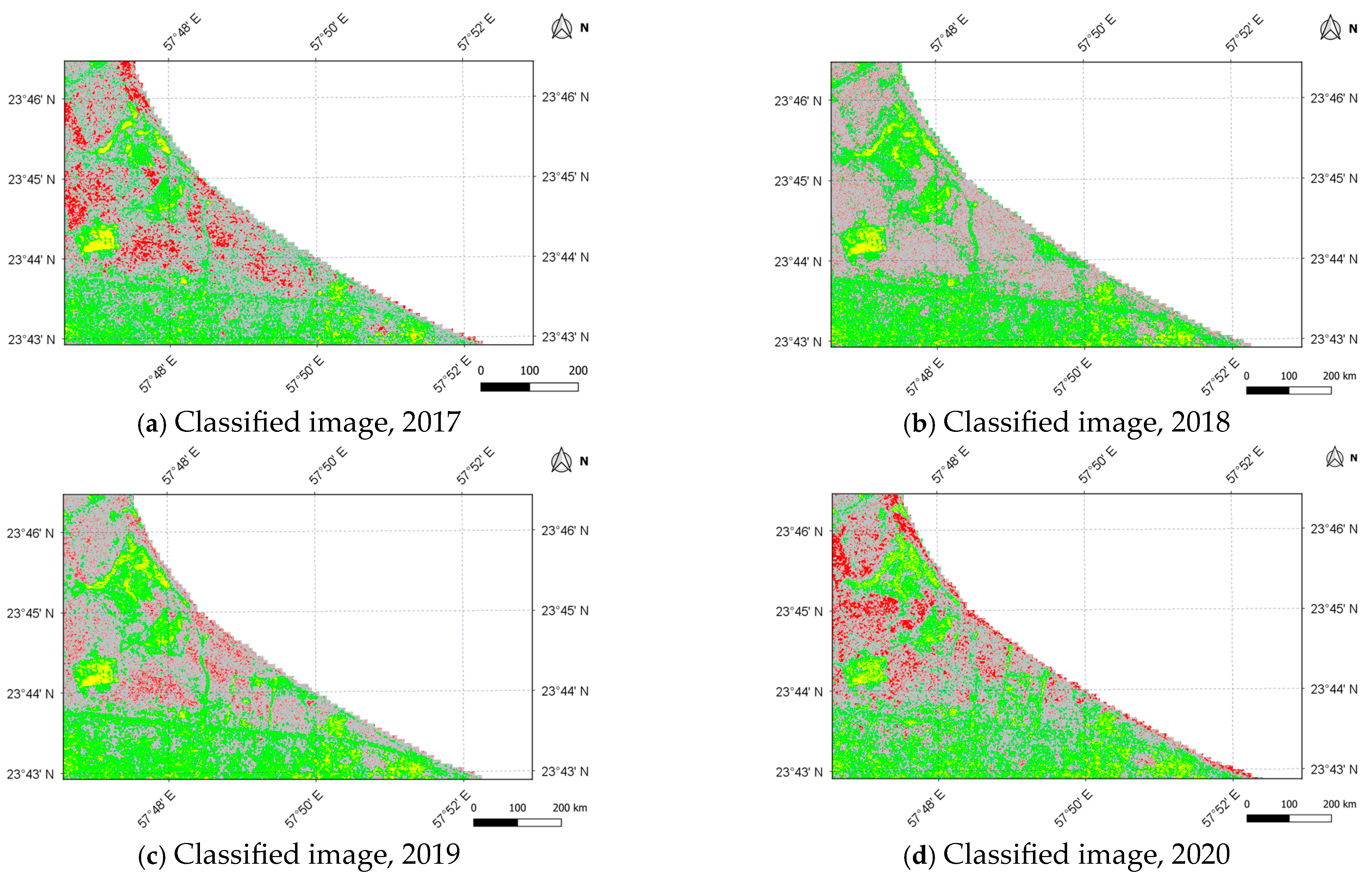
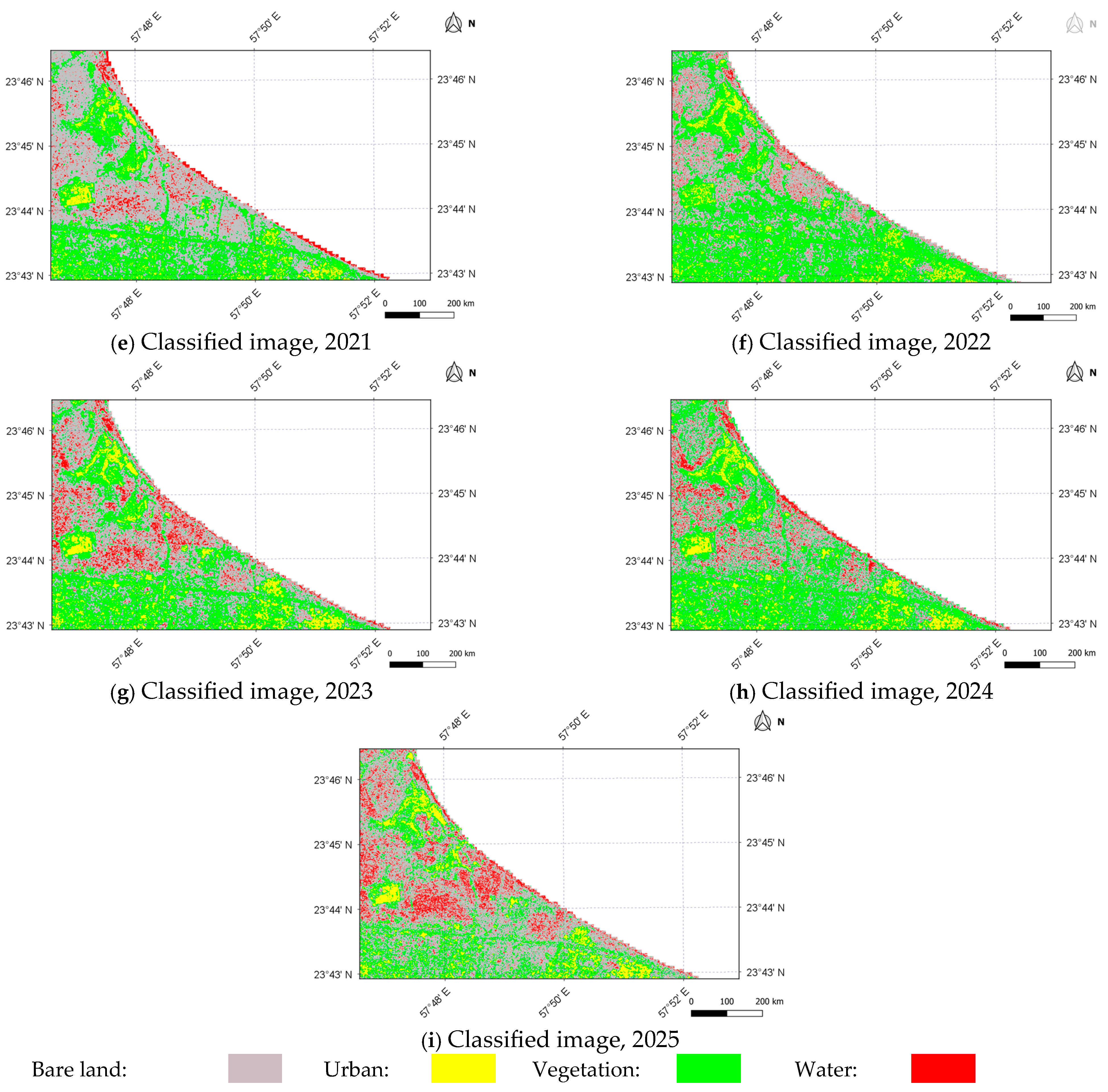
Figure 6 illustrates that the land cover distribution in the Al-Batinah Coastal region of Al-Sawadi that includes the urban area along the coastline shows a clearly negative correlation between urban, vegetation, and bare soil regions. The water distribution, highlighted in red, has a significant increase in variation.
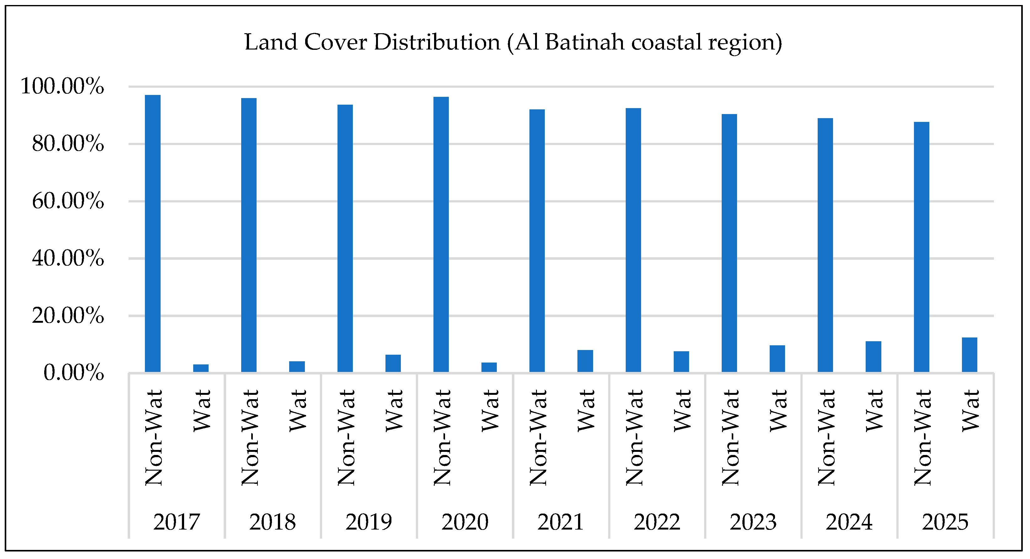
Based on the land cover distribution of Al-Sawadi coastal area depicted in Figure 7, there is a significant shift in the region’s topography, with water area coverage increasing gradually from 2.99% in 2017 to 12.36% in 2026. This indicates that there is a substantial expansion of water segments in the coastal area that implies a substantial implication for tourism in the region.
From Figure 8, it can be seen that the percentages of the water areas for the Al-Sawadi coastal area depict a similar increasing trend in their changes during the 2017–2025 period. This poses a severe risk to the coastal infrastructure, affecting tourism and urban inhabitation.
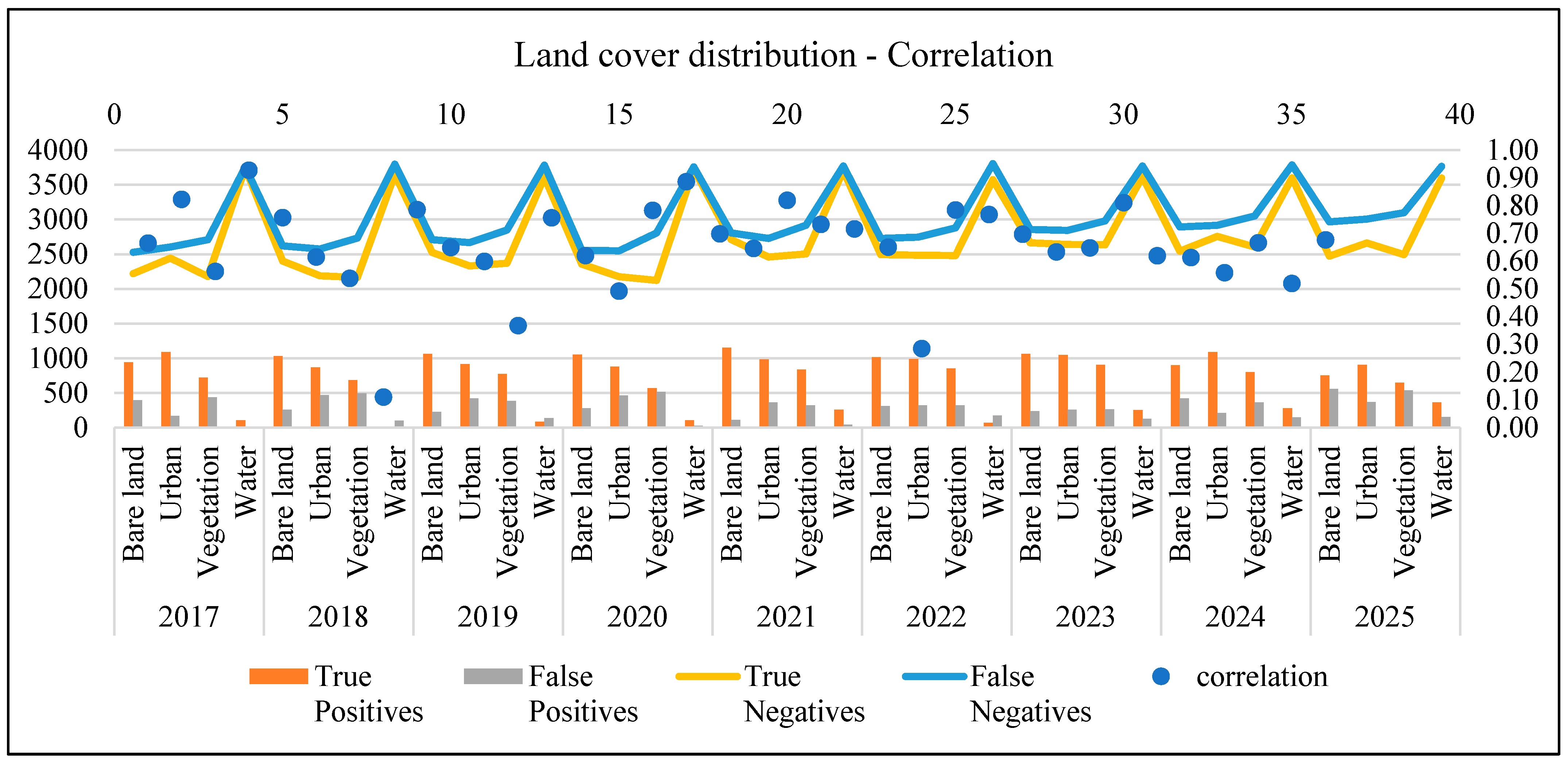
As observed in Figure 8, the evaluation of classification performance and the correlation metrics for all four land cover segments show a highly cyclical pattern in True and False Negatives. The water class has a consistently higher correlation coefficient exceeding 0.80 while the bare land, vegetation, and urban classes have a fluctuating correlation indicating possibilities of soil erosion and varying environmental conditions in the region.
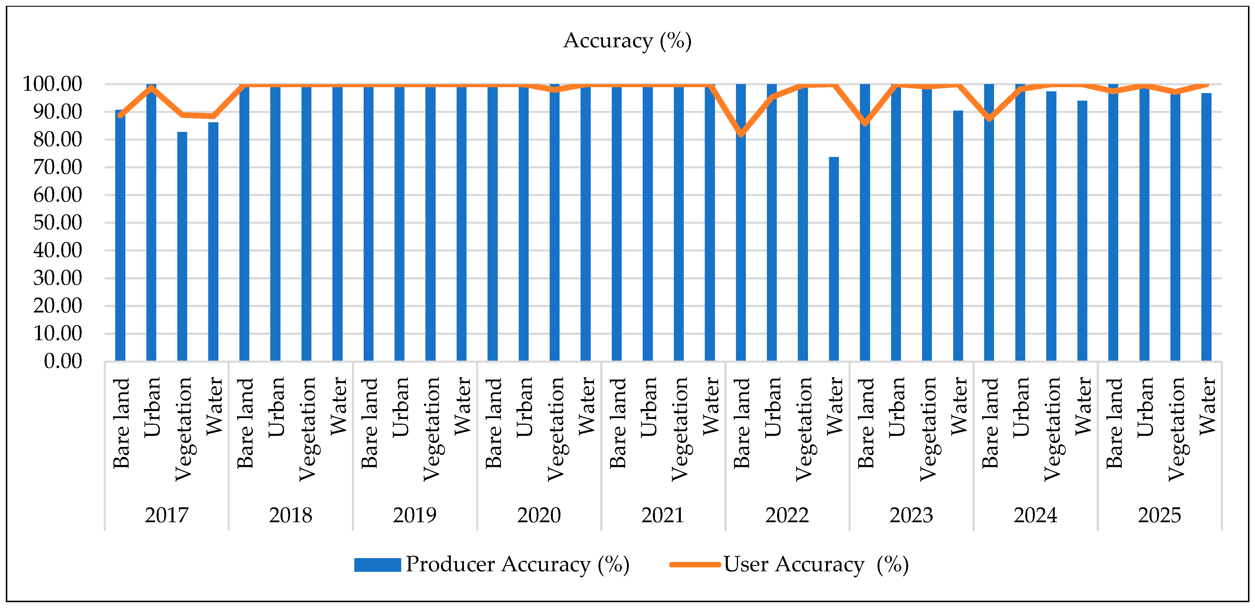
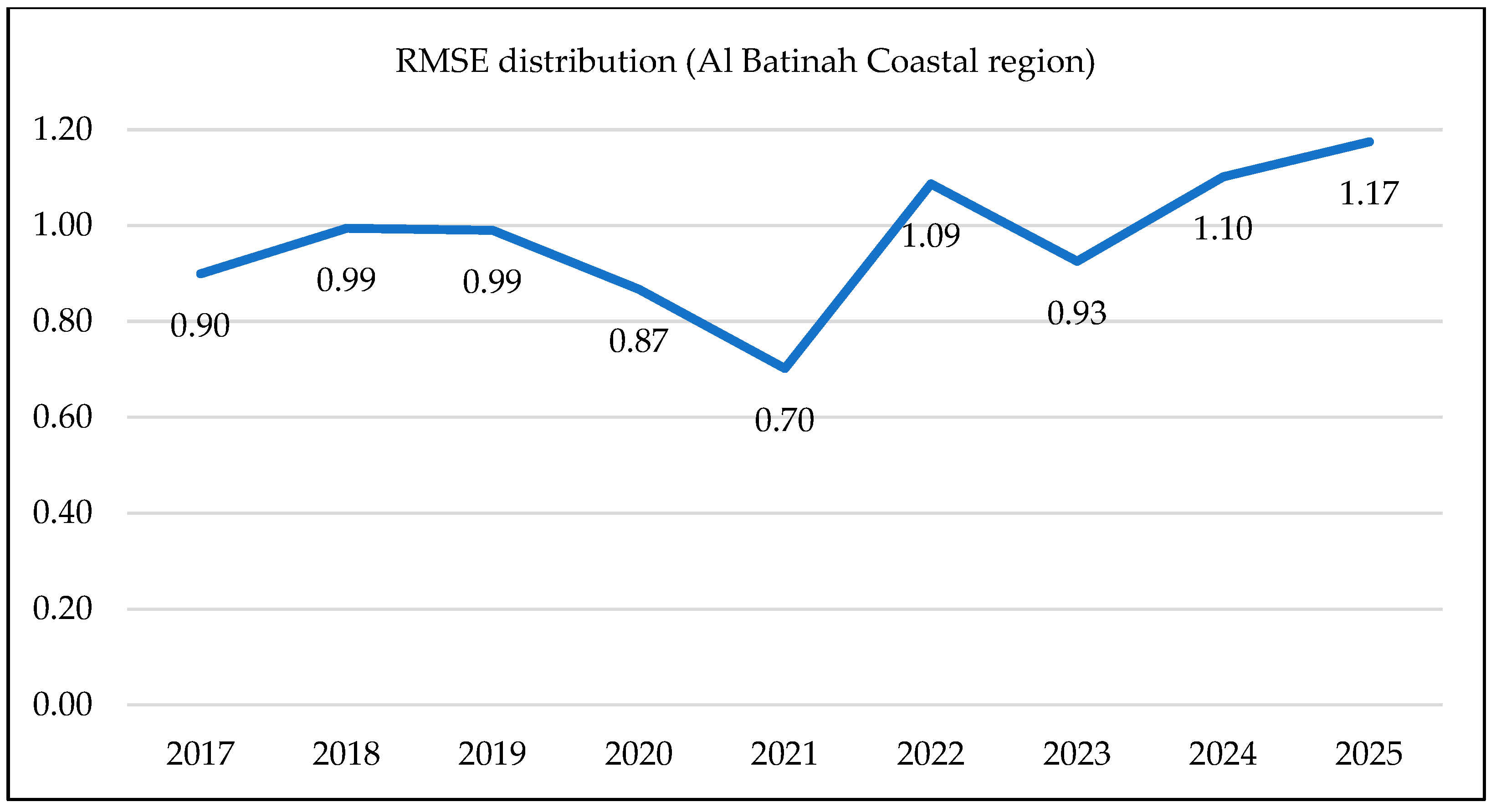
As observed in Figure 9, the results indicate overall reliable performance of the RF technique applied to the satellite imagery, with a minor year-on-year variation. The lowest RMSE value is 0.7, in 2021, reflecting the highest model accuracy, which gradually increased until 1.2, demonstrating acceptable classification accuracy. This suggests higher data complexity, affecting the prediction precision. The producer and user accuracy from Figure 10 indicates consistency in having higher accuracies between the years 2017 and 2025. However, the producer accuracy shows a significant difference in performance, dropping below average for bare land in the years 2022 and 2024 and water in 2023.
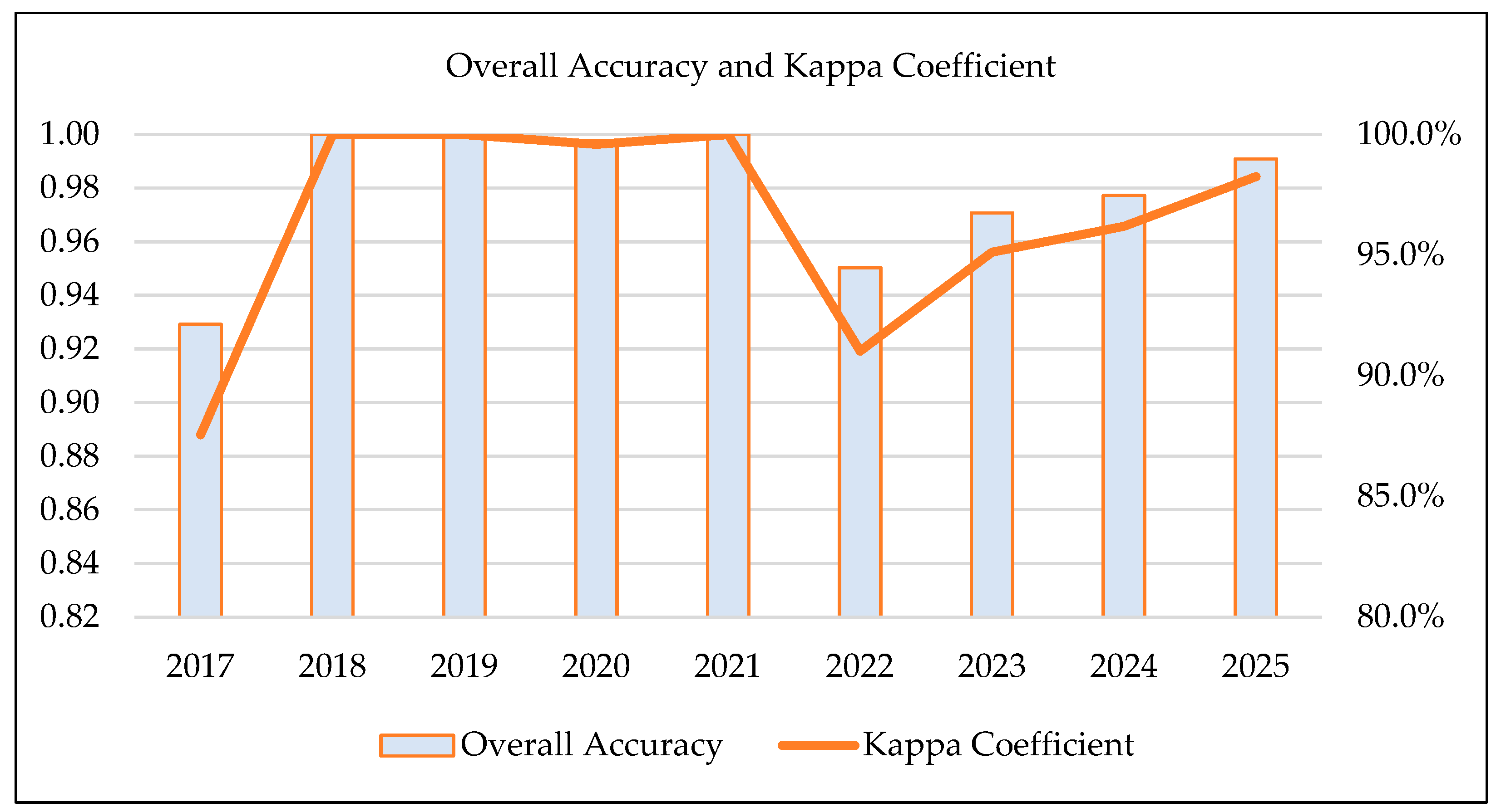
The overall accuracy, as presented in Figure 11, is consistent over the years, ranging between 92.1% and 100%, and the Kappa coefficient confirms a stronger agreement, ranging from 0.89 to 1.0. This finding validates the shifts observed in land cover.
Overall, the results achieved from the RF and SVM models demonstrate a higher reliability with the measurable expansion of water areas. The water area represented 2.99% of the Al-Sawadi coastal area in 2017 and enlarged to 12.36% by the year 2025. This trend suggests a sustained encroachment on urban and bare soil areas.

Accuracy and Validation of Findings

The results have been derived through a post-classification technique in which cross validation was performed using the Random Forest and Support Vector Machine techniques. These indicate that the change in water area consistently increased year-on-year, with the largest change observed between the years 2020–2021 and the smallest change during the years 2021–2022. Although, during the years 2019–2020, there was a larger drop in percentage, and yet this had a negligible impact on the overall increase in water area over the period of study. The average overall accuracy over the study period from 2017 to 2025 was found to be 97.7%. As shown in Table 2 below, the effect size was calculated using a global pooled SD of 3.15, considering the water area in consecutive years. This depicts the variance-weighted trend synthesis within a robust and a structured pooling method that ensures consistency.

6. Discussion

The study region has been analyzed by classifying the land covers and identifying the change patterns over the years. The water, bare soil, vegetation, and urban areas were obtained as a land cover distribution, using RF and SVM classification models. Both of these classification methods consistently provided higher overall accuracy, depicting strong variability in precision for the water class. The RF results offer a quantitative measure of the land cover distribution over time. The RF distribution data indicate a critical trend in the coastal areas, with water areas increasing dramatically. With the SVM model, the OA and the KC are exceptionally higher, with the OA ranging from 92.1% to 100%, and the KC ranging from 0.89 to 1.0, confirming the models as highly reliable. A comparative analysis of the RF and SVM models in terms of performance towards the overall as well as in water area classification is provided in Table 3, below.
A significant change pattern observed in the distribution of water area shows the stretching from 2.99% in 2017 to 12.36% in 2025. This could be driven by the rise in sea-level and surge in the strong rainwater current towards coastal areas due to floods. A noticeably smaller change pattern is observed with the decrease in OA and KC in 2022, which coincides with the decline in PA and RMSE. Additionally, the oceanographic systems of the Al-Batinah coastline are characterized by a semi-diurnal tidal cycle of approximately 2.1 m during spring tides. While relatively long-term coastline erosion is mostly driven by seasonal wave setups and interrupted coastal sand flow due to infrastructure upgrades, the tidal cycle has a critical role in controlling the spatial distribution of wave energy at the coastline. The tides normally act as a periodic catalyst for localized erosion surges. Notably, though, these coastline water-level changes due to tidal trends constitute a smaller area of the overall changes in the study region; this is now addressed by evaluating the precise timestamp for all satellite images using FES2014 global hydrodynamic tide model, and coordinating with the local tide table benchmark for the nearby Muscat and Minal Al-Fahal port. These corrections have significantly improved the robustness and scientific validity of the findings. Therefore, the study maps dynamic water-related land cover changes and does not quantify erosion rates. The outcomes confirm that the water encroachment in the coastal areas has a profound impact on the larger coastal region, including the coastline, and requires management strategies to ensure long-term climate resilience.

7. Conclusions

The coastal regions of Al-Batinah require a resilient infrastructure to mitigate climate risks, ensuring the long-term viability of these tourism destinations. Based on the results, the overall accuracy levels were found to be higher when using the ML models, with a significant increase to 100% between the years 2018 and 2021. Exceptionally, during the year 2022, the SVM-based water-level accuracy was only 73.68%. The water area had increased to 7.96% in 2021, and this was followed by a gradual increase to a peak of 12.36% in the year 2025. This consistently suggests a change pattern in the land covers. As identified through meta-analysis, the combined effect suggests that there is a significant systematic change that could be attributed to coastal erosion or flooding in the region. A comprehensive vulnerability assessment is required for the coastal infrastructure and critical urban areas. This process could be supported by a geospatial verification process using a high-resolution imagery analysis in larger coastal areas that demonstrate a significant increase in water classified areas. Based on these findings, a revised land-use policy and other engineering interventions could address the risk of water encroachments in the coastal areas. Additionally, the construction of sustainable infrastructure can prevent permanent loss of coastal areas and contribute towards regenerative tourism. As a limitation, the scope of this study is limited to the Al-Batinah governorate, and its validity is completely dependent on the results from processed Sentinel images. In future, such studies should expand to the coastal regions of other governorates and integrate qualitative data such as interviews from local residents and businesses. The outcomes from such work can be expected to further bridge the gap between the remote observation of the impact on tourism and the on-the-ground reality of the region.

Author Contributions

Conceptualization, M.S., V.R. and A.A.A.B.; methodology, M.S., V.R.; software, M.S., V.R.; validation, M.S. and V.R.; formal analysis, M.S. and V.R.; investigation, M.S. and V.R.; data curation, M.S. and V.R.; writing—original draft preparation, M.S. and V.R.; writing—review and editing, M.S. and A.A.A.B.; resources, M.S. and V.R.; visualization, M.S. and A.A.A.B.; supervision and proofreading, V.R. and A.A.A.B. All authors have read and agreed to the published version of the manuscript.

Funding

This research received no external funding.

Data Availability Statement

The Sentinel-1 satellite images utilized to classify and analyze coastal regions of the Al-Batinah region, Oman, may be made available if requested.

Acknowledgments

The Article Processing Charge is funded by Majan University College (MUC), Muscat, Sultanate of Oman.

Conflicts of Interest

The authors declare no conflicts of interest.

Abbreviations

The following abbreviations are used in this manuscript:
UNESCOUnited Nations Educational, Scientific and Cultural Organization
GDPGross Domestic Product
UNSDGUnited Nations Sustainable Development Goals
SVMSupport Vector Machine
RFRandom Forest
MLMachine Learning
CNNConvolutional Neural Network
WHMWestern Hajar Mountains
CVICoastal Vulnerability Index
GCCGulf Cooperation Council
GISGeographic Information System
LULCLand Use and Land Cover
OBIAObject-Based Image Analysis
UAVUnmanned Aerial Vehicle
DEMDigital Elevation Model
GRDGround Range Detected
RMSERoot Mean Square Error

References

  1. Al Riyami, H.; Almuhrzi, H.; Scott, N. Heritage Hotel Experiences in Nizwa, Oman. Int. J. Tour. Res. 2022, 24, 169–180. [Google Scholar] [CrossRef] [Scilit]
  2. Shani, S.K.; Shaker, I.N.; Ali, S.A.J. The Role of Blue Economy in Economic Diversification: Omani Economy Case Study for The Period (1990–2022). Int. J. Econ. Financ. Stud. 2024, 16, 79–108. [Google Scholar]
  3. Ambusaidi, A.; Al-Dayri, H.; Al-Sumari, M. The Effect of Sustainable Environmental Tourism Training on the Development of Eighth-Grade Omani Students’ Attitudes towards the Environment and Their Inclination to Engage in Entrepreneurship in Environmental Tourism Projects. Cogent Educ. 2024, 11, 2400745. [Google Scholar] [CrossRef] [Scilit]
  4. Al Hinai, A.; Jayasuriya, H. Agricultural Sustainability through Agritourism in Oman and Potentials for Adoption. In Proceedings of the 2nd International Conference on Agriculture, Food Security and Safet, Virtual, 15–16 January 2021; Volume 2, pp. 83–91. [Google Scholar]
  5. Al-Riyami, H.; Scott, N.; Ragab, A.; Jafari, J. Sustainable Tourism in Oman: Lessons for the Gulf Cooperation Community Region. In International Tourism Development and the Gulf Cooperation Council States: Challenges and Opportunities; Stephenson, M.L., Al-Hamarneh, A., Eds.; Taylor & Francis: Abingdon, UK, 2017; pp. 145–160. [Google Scholar]
  6. Hafidh, H.A.; Rashid, Z.A. The Impact of Tourism Development on Economic Development: The Case of Zanzibar. Asian J. Educ. Soc. Stud. 2021, 18, 41–50. [Google Scholar] [CrossRef] [Scilit]
  7. Hosni, W.; Balushi, F.; Widyarto, S.; Jamaluddin, Z. Conceptual Framework on The Effect of Digital Marketing and Competitive Advantage on Recovery Performance of Tourism in Oman. Int. J. Account. Financ. Bus. (IJAFB) 2023, 8, 171–184. [Google Scholar] [CrossRef] [Scilit]
  8. Abdelfattah, F.; Al-Alawi, A.; Abdullahi, M.S.; Salah, M. Embracing the Industrial Revolution: The Impact of Technological Advancements and Government Policies on Tourism Development in Oman. J. Policy Res. Tour. Leis. Events 2023, 18, 22–46. [Google Scholar] [CrossRef] [Scilit]
  9. Sun, P.-C.; Ng, S.-L. From Shores to Systems: The Evolution of Coastal and Island Tourism Research. Water 2025, 17, 3199. [Google Scholar] [CrossRef] [Scilit]
  10. Sana, A.; Chitrakar, P.; Baawain, M.; Al-Mamun, A. Baseline Measurements of Waves and Currents along the Coast of Oman. J. Mar. Sci. Eng. 2023, 11, 1711. [Google Scholar] [CrossRef] [Scilit]
  11. Er-Ramy, N.; Nachite, D.; Anfuso, G.; Azaaouaj, S. The Sector Analysis as a Coastal Management Tool for Sustainable Tourism Development on the Mediterranean Coast of Morocco. Sustainability 2023, 15, 12581. [Google Scholar] [CrossRef] [Scilit]
  12. Lukoseviciute, G.; Panagopoulos, T. Management Priorities from Tourists’ Perspectives and Beach Quality Assessment as Tools to Support Sustainable Coastal Tourism. Ocean Coast. Manag. 2021, 208, 105646. [Google Scholar] [CrossRef] [Scilit]
  13. Smith, T.F.; Elrick-Barr, C.E.; Thomsen, D.C.; Celliers, L.; Le Tissier, M. Impacts of Tourism on Coastal Areas. Camb. Prism. Coast. Futures 2023, 1, e5. [Google Scholar] [CrossRef] [Scilit]
  14. Nitivattananon, V.; Srinonil, S. Enhancing Coastal Areas Governance for Sustainable Tourism in the Context of Urbanization and Climate Change in Eastern Thailand. Adv. Clim. Change Res. 2019, 10, 47–58. [Google Scholar] [CrossRef] [Scilit]
  15. Thouret, J.C.; D’Ercole, R. Vulnérabilité Aux Risques Naturels En Milieu Urbain: Effets, Facteurs et Réponses Sociales. Cah. Sci. Hum. 1996, 32, 407–422. [Google Scholar]
  16. Latif, M.M.H.A.; Yong, G.Y. Coastal Erosion in The Unprotected and Protected Sections At Berakas: A Comparative Study in Brunei Darussalam. Southeast Asia A Multidiscip. J. 2021, 21, 45–62. [Google Scholar] [CrossRef] [Scilit]
  17. Al Ruheili, A.; Boluwade, A. Towards Quantifying the Coastal Vulnerability Due to Natural Hazards Using the InVEST Coastal Vulnerability Model. Water 2023, 15, 380. [Google Scholar] [CrossRef] [Scilit]
  18. Viswanathan, H.S. Coastal Tourism Sustainability in Abu Dhabi, United Arab Emirates: Environment, Protected Areas, and Culture. Doctoral Dissertation, University of Washington, Seattle, WA, USA, 2022. [Google Scholar]
  19. Moussa, L.G.; Mohan, M.; Burmeister, N.; King, S.A.; Burt, J.A.; Rog, S.M.; Ewane, E.B. Mangrove Ecotourism along the Coasts of the Gulf Cooperation Council Countries: A Systematic Review. Land 2024, 13, 1351. [Google Scholar] [CrossRef] [Scilit]
  20. Biladi, B. Tourism versus Sustainable Development Goals (SDG) Tourism–an Element of Economic Growth of Metropolitan Cities, Entrepreneurs. Asia Proc. Soc. Sci. 2021, 7, 154–158. [Google Scholar] [CrossRef] [Scilit]
  21. Colak, A.T.I. Geospatial Analysis of Shoreline Changes in the Oman Coastal Region (2000-2022) Using GIS and Remote Sensing Techniques. Front. Mar. Sci. 2024, 11, 1305283. [Google Scholar] [CrossRef] [Scilit]
  22. Yousuf, J.B.; Bose, S.; Mbaga, M.D. Are Small-Scale Fishers in Oman Technically Efficient? The Case of Al-Batinah Coastal Fisheries. J. Ocean Coast. Econ. 2021, 8, 2. [Google Scholar] [CrossRef] [Scilit]
  23. AlRuheili, A.M. A Tale of Shaheen’s Cyclone Consequences in Al Khaboura City, Oman. Water 2022, 14, 340. [Google Scholar] [CrossRef] [Scilit]
  24. Hereher, M.; Al-Awadhi, T.; Al-Hatrushi, S.; Charabi, Y.; Mansour, S.; Al-Nasiri, N.; El-Kenawy, A. Assessment of the Coastal Vulnerability to Sea Level Rise: Sultanate of Oman. Environ. Earth Sci. 2020, 79, 369. [Google Scholar] [CrossRef] [Scilit]
  25. Al-Awadhi, T.; Nasiri, N.A.; Ahsan, R.; Hereher, M.; Charabi, Y. An Integrated Approach to Coastal Zone Management to Control Development and Ensure Sustainability in a Rapidly Increasing Coastal Urban Environment: The Sultanate of Oman. Environ. Justice 2022, 15, 214–227. [Google Scholar] [CrossRef] [Scilit]
  26. Al-Ismaily, S.; Al-Mayhai, A.; Kacimov, A.; Al-Rawahy, Y.; Al-Shibli, A.; Al-Mukhaini, N.; Al-Balushi, S. Pedo-Archeo Heritage Sites in Northern Oman: From Traditional Soil-Sediment Materials in Building Engineering to Booming Tourism. Geoheritage 2026, 18, 51. [Google Scholar] [CrossRef] [Scilit]
  27. Al-Maskari, H.A. Exploring Tourism Opportunities in Northern Al-Batinah Region: A SWOT Analysis Approach. Res. J. Psychol. Sociol. Anthropol. 2024, 10, 16–27. [Google Scholar] [CrossRef] [Scilit]
  28. Kessler, K. Heritage Tourism and Orientalism: The Promotion of an Authentic Arabian Experience in Oman. J. Arab. Stud. 2025, 14, 73–92. [Google Scholar] [CrossRef] [Scilit]
  29. Zheng, H.; Li, X.; Wan, J.; Xu, M.; Liu, S.; Yasir, M. Automatic Coastline Extraction Based on the Improved Instantaneous Waterline Extraction Method and Correction Criteria Using SAR Imagery. Sustainability 2023, 15, 7199. [Google Scholar] [CrossRef] [Scilit]
  30. Chen, J.; Chen, H.; Smith, T.F.; Rangel-Buitrago, N. Analyzing the Impact and Evolution of Ocean & Coastal Management: 30 Years in Retrospect. Ocean Coast. Manag. 2023, 242, 106697. [Google Scholar] [CrossRef] [Scilit]
  31. Azarnivand, A.R.; Sadrinasab, M.; Nasseri, M. Climate Change Impacts on the Seasonal Variation of Hydro-Physical Characteristics in the Persian Gulf. Estuaries Coasts 2023, 46, 302–322. [Google Scholar] [CrossRef] [Scilit]
  32. Abdalla, O.; Al-Abri, R.B.Y. Groundwater Recharge in Arid Areas Induced by Tropical Cyclones: Lessons Learned from Gonu 2007 in Sultanate of Oman. Environ. Earth Sci. 2011, 63, 229–239. [Google Scholar] [CrossRef] [Scilit]
  33. Al-Shanfari, A.A.M. Role of Tourism Activity in Achieving Economic Development in the Sultanate of Oman. J. Adv. Agric. Res. 2023, 28, 842–851. [Google Scholar] [CrossRef] [Scilit]
  34. Davenport, J.; Davenport, J.L. The Impact of Tourism and Personal Leisure Transport on Coastal Environments: A Review. Estuar. Coast. Shelf Sci. 2006, 67, 280–292. [Google Scholar] [CrossRef] [Scilit]
  35. Scala, P.; Toimil, A.; Álvarez-Cuesta, M.; Manno, G.; Ciraolo, G. Mapping Decadal Land Cover Dynamics in Sicily’s Coastal Regions. Sci. Rep. 2024, 14, 22222. [Google Scholar] [CrossRef] [Scilit] [PubMed]
  36. Ferreira, T.A.B.; Aquino Da Silva, A.G.; Reyes Perez, Y.A.; Stattegger, K.; Vital, H. Evaluation of Decadal Shoreline Changes along the Parnaíba Delta (NE Brazil) Using Satellite Images and Statistical Methods. Ocean Coast. Manag. 2021, 202, 105513. [Google Scholar] [CrossRef] [Scilit]
  37. Theocharidis, C.; Prodromou, M.; Doukanari, M.; Kalogirou, E.; Eliades, M.; Kontoes, C.; Hadjimitsis, D.; Neocleous, K. Integrated Coastal Vulnerability Index (ICVI) Assessment of Protaras Coast in Cyprus: Balancing Tourism and Coastal Risks. Geographies 2025, 5, 12. [Google Scholar] [CrossRef] [Scilit]
  38. Scala, P.; Manno, G.; Ciraolo, G. Coastal Dynamics Analyzer (CDA): A QGIS Plugin for Transect Based Analysis of Coastal Erosion. SoftwareX 2024, 28, 101894. [Google Scholar] [CrossRef] [Scilit]
  39. Quijada, I.D.; Urbaneja, I.B.D.; Martínez, W.P.; Jara, J.V. Satellite-Based Assessment of Coastal Morphology Changes in Pichilemu Bay, Chile. Eng. Proc. 2025, 94, 24. [Google Scholar] [CrossRef] [Scilit]
  40. De Paula, D.P.; Lima, J.C.; Barros, E.L.; Santos, J.D.O. Coastal Erosion and Tourism: The Case of the Distribution of Tourist Accommodations and Their Daily Rates. Geogr. Environ. Sustain. 2021, 14, 110–120. [Google Scholar] [CrossRef] [Scilit]
  41. Phillips, M.R.; Jones, A.L. Erosion and Tourism Infrastructure in the Coastal Zone: Problems, Consequences and Management. Tour. Manag. 2006, 27, 517–524. [Google Scholar] [CrossRef] [Scilit]
  42. Dong, W.S.; Ismailluddin, A.; Yun, L.S.; Ariffin, E.H.; Saengsupavanich, C.; Maulud, K.N.A.; Yunus, K. The Impact of Climate Change on Coastal Erosion in Southeast Asia and the Compelling Need to Establish Robust Adaptation Strategies. Heliyon 2024, 10, e25609. [Google Scholar] [CrossRef] [Scilit] [PubMed]
  43. Chawalit, C.; Boonpook, W.; Sitthi, A.; Torsri, K.; Kamthonkiat, D.; Tan, Y.; Suwansaard, A.; Nardkulpat, A. Geoinformatics and Machine Learning for Shoreline Change Monitoring: A 35-Year Analysis of Coastal Erosion in the Upper Gulf of Thailand. IJGI 2025, 14, 94. [Google Scholar] [CrossRef] [Scilit]
  44. Alexandrakis, G.; Manasakis, C.; Kampanis, N.A. Valuating the Effects of Beach Erosion to Tourism Revenue. A Management Perspective. Ocean Coast. Manag. 2015, 111, 1–11. [Google Scholar] [CrossRef] [Scilit]
  45. Cinelli, I.; Anfuso, G.; Privitera, S.; Pranzini, E. An Overview on Railway Impacts on Coastal Environment and Beach Tourism in Sicily (Italy). Sustainability 2021, 13, 7068. [Google Scholar] [CrossRef] [Scilit]
  46. Thinh, N.A.; Thanh, N.N.; Tuyen, L.T.; Hens, L. Tourism and Beach Erosion: Valuing the Damage of Beach Erosion for Tourism in the Hoi An World Heritage Site, Vietnam. Environ. Dev. Sustain. 2019, 21, 2113–2124. [Google Scholar]
  47. Ankrah, J.; Monteiro, A.; Madureira, H. Shoreline Change and Coastal Erosion in West Africa: A Systematic Review of Research Progress and Policy Recommendation. Geosciences 2023, 13, 59. [Google Scholar] [CrossRef] [Scilit]
  48. Cruz-Ramírez, C.J.; Chávez, V.; Silva, R.; Muñoz-Perez, J.J.; Rivera-Arriaga, E. Coastal Management: A Review of Key Elements for Vulnerability Assessment. JMSE 2024, 12, 386. [Google Scholar] [CrossRef] [Scilit]
  49. da Rocha, A.; Coelho-Rocha, A.R.; Do Nascimento, E.S. Unveiling the Unheard Voices of Low-Income Consumers in an Emerging Market. J. Mark. Manag. 2025, 41, 1575–1608. [Google Scholar] [CrossRef] [Scilit]
  50. Roy, M.; Medhekar, A. Tourism-Led Growth Hypothesis: A Global Perspective Bibliographic Analysis. Asia Pac. J. Tour. Res. 2026, 31, 302–333. [Google Scholar] [CrossRef] [Scilit]
  51. Alhowaish, A.K. The Blue Economy in the Arabian Gulf: Trends, Gaps, and Pathways for Sustainable Coastal Development. Sustainability 2025, 17, 8809. [Google Scholar] [CrossRef] [Scilit]
  52. Abdel Aziz, K.M. Quantitative Monitoring of Coastal Erosion and Changes Using Remote Sensing in a Mediterranean Delta. Civ. Eng. J. 2024, 10, 1842–1862. [Google Scholar] [CrossRef] [Scilit]
  53. Pech-May, F.; Aquino-Santos, R.; Delgadillo-Partida, J. Sentinel-1 SAR Images and Deep Learning for Water Body Mapping. Remote Sens. 2023, 15, 3009. [Google Scholar] [CrossRef] [Scilit]
  54. Al Mahrizi, A.S.K.; Gray, T.; Gregory-Smith, D.; Stead, S.M. The Role of Stakeholder Participation in Oman’s Tourism Planning System. Tour. Plan. Dev. 2024, 21, 881–916. [Google Scholar] [CrossRef] [Scilit]
  55. Heidari, M.J.; Bores, J.G.; Najafi, A.; Alavi, S.J. A 3D Convolutional Neural Network Approach for Monitoring Land Cover Change Using Sentinel-2 Satellite Imagery. Front. For. Glob. Change 2025, 8, 1672747. [Google Scholar] [CrossRef] [Scilit]
  56. Dung, L.N.; Dong, K.T.; Chieu, V.D. Comparison of Boosting Algorithms for Land Cover Mapping Using Object-Based Classification. Rev. Teledetec. 2024, 64, 24531. [Google Scholar] [CrossRef] [Scilit]
  57. Chen, Y.; Shi, Z.; Aziz, A.; Zheng, S.; Ilniyaz, O.; Azadi, H.; Voorde, T.V.d.; Kurban, A. Improving Altitudinal Accuracy of Sentinel-1 InSAR DEM in Arid Flat Terrain: A Machine Learning Approach with UAV Photogrammetry and Multi-Source Data. Int. J. Digit. Earth 2024, 18, 2600903. [Google Scholar] [CrossRef] [Scilit]
  58. Shandu, I.D.; Xulu, S.; Gebreslasie, M. Enhancing Land Cover Classification in the Heterogeneous Landscape by Integrating Auxiliary Data with Sentinel-2 Imagery Using the Random Forest Algorithm. Front. Remote Sens. 2024, 6, 1697897. [Google Scholar] [CrossRef] [Scilit]
  59. Harani, P.; Gautam, S.; Joshi, S.K.; Ho, C.-H. Spatio-Temporal Analysis of Land Use Transformations and Their Environmental Implications in the Thamirabarani River Basin, India. Front. Remote Sens. 2024, 5, 1732414. [Google Scholar] [CrossRef] [Scilit]
  60. Dataspace.Copernicus. Dataspace.Copernicus.Eu 2023. Available online: https://scihub.copernicus.eu/ (accessed on 1 June 2026).
  61. Akar, Ö.; Güngör, O. Classification of Multispectral Images Using Random Forest Algorithm. J. Geod. Geoinf. 2012, 1, 105–112. [Google Scholar] [CrossRef] [Scilit]
  62. Siddique, M.; Ahmed, T. CCD-Conv1D: A Deep Learning Based Coherent Change Detection Technique to Monitor and Forecast Floods Using Sentinel-1 Images. Remote Sens. Appl. Soc. Environ. 2025, 37, 101440. [Google Scholar] [CrossRef] [Scilit]
  63. Lyard, F.H.; Allain, D.J.; Cancet, M.; Carrère, L.; Picot, N. FES2014 Global Ocean Tide Atlas: Design and Performance. Ocean Sci. 2021, 17, 615–649. [Google Scholar] [CrossRef] [Scilit]
  64. Piccioni, G.; Dettmering, D.; Schwatke, C.; Passaro, M.; Seitz, F. Design and Regional Assessment of an Empirical Tidal Model Based on FES2014 and Coastal Altimetry. Adv. Space Res. 2021, 68, 1013–1022. [Google Scholar] [CrossRef] [Scilit]
  65. Suurmond, R.; Van Rhee, H.; Hak, T. Introduction, Comparison, and Validation of META-ESSENTIALS: A Free and Simple Tool for Meta-analysis. Res. Synth. Methods 2017, 8, 537–553. [Google Scholar] [CrossRef] [Scilit] [PubMed]
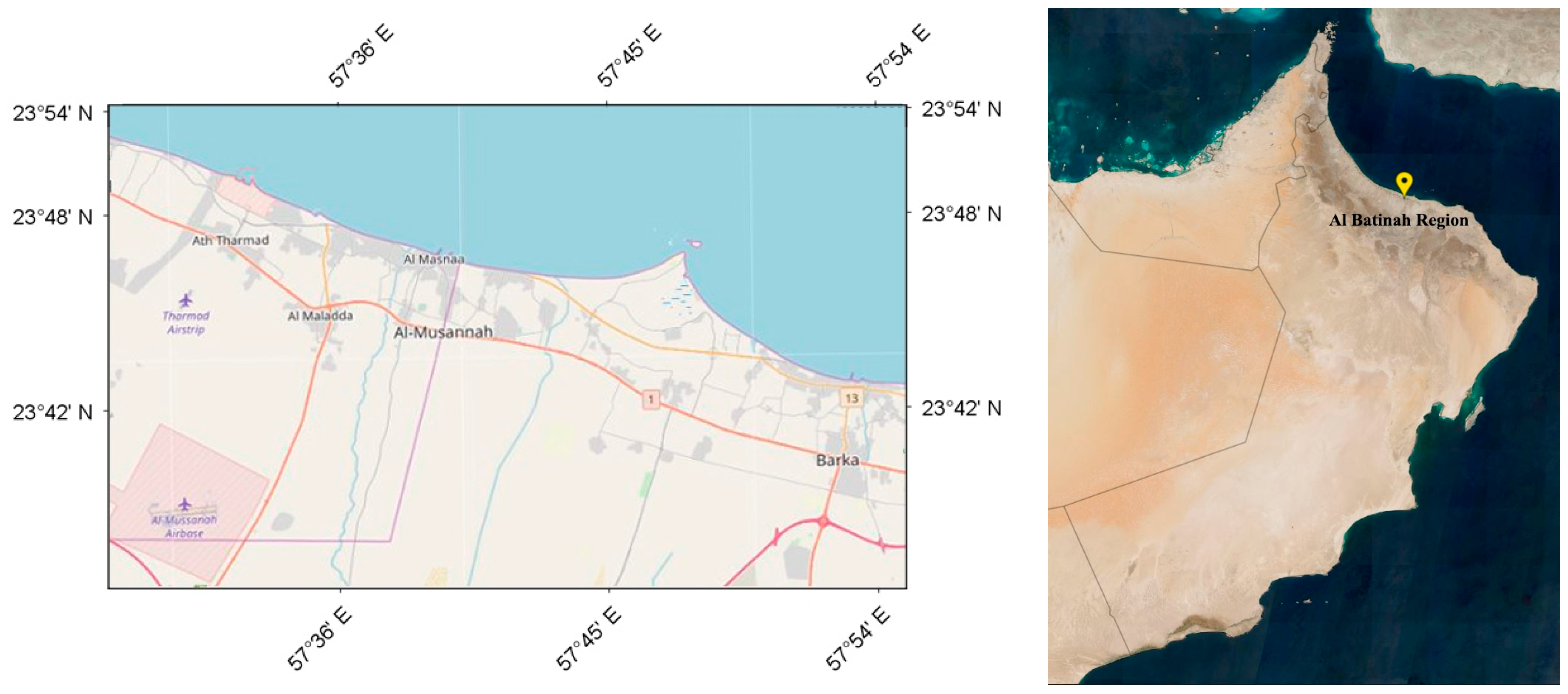
Figure 1. Study Area—Al-Batinah region, Oman. Source: Copernicus Data Hub [60].
Coasts 06 00031 g001
Figure 2. Pre-processed images of South Al-Batinah region, Oman, from (a) to (i), for applying radiometric calibration, speckle filtering and geometric corrections to implement classification techniques.
Coasts 06 00031 g002
Figure 3. Image processing—Sentinel-1 satellite images of Al-Batinah region, Oman.
Coasts 06 00031 g003
Figure 4. RF-based land cover distribution, images from (a) to (i), as classified, for the South Al-Batinah region.
Coasts 06 00031 g004
Figure 5. RF—Water and Non-Water distribution—South Al-Batinah region.
Coasts 06 00031 g005
Figure 6. Land cover distribution, images (a) to (i)—Al-Sawadi coastal area, Al-Batinah.
Coasts 06 00031 g006aCoasts 06 00031 g006b
Figure 7. Graphical representation of land cover distribution—Al-Sawadi coastal area, Al-Batinah.
Coasts 06 00031 g007
Figure 8. Land cover distribution—Al-Sawadi coastal area, Oman.
Coasts 06 00031 g008
Figure 9. RF based RMSE distribution– Al-Sawadi coastal area, Al-Batinah.
Coasts 06 00031 g009
Figure 10. SVM-based RMSE distribution—Al-Sawadi coastal area, Al-Batinah.
Coasts 06 00031 g010
Figure 11. SVM—Overall Accuracy and Kappa Coefficient.
Coasts 06 00031 g011
Table 1. Acquisition information of the Satellite (Sentinel 1A) images utilized.
Acquisition IdentificationDates
S1A_IW_GRDH_1SDV_…k (k = 1, 2, 3, 4, 5 ………… 9)
120170420T141556_20170420T141621_016229_01AD55_E90320 April 2017
220180415T141602_20180415T141627_021479_024FFA_568B15 April 2018
320190410T141608_20190410T141633_026729_030061_661910 April 2019
420200428T141615_20200428T141640_032329_03BDD1_AE4F28 April 2020
520210423T141621_20210423T141646_037579_046E98_060123 April 2021
620220418T141626_20220418T141651_042829_051CAA_A9D118 April 2022
720230413T141632_20230413T141657_048079_05C78D_151413 April 2023
820240407T141637_20240407T141702_053329_067746_68697 April 2024
920250414T141629_20250414T141654_058754_07473D_9DD914 April 2025
Table 2. Effect size based on water area percentage, from two consecutive years.
Year GroupStandard Deviation
|X2 − X1|
Standard Error
(SE)
Effect Size
(d)
2017–20181.052.400.33
2018–20192.282.010.72
2019–20202.712.08−0.86
2020–20214.352.001.38
2021–20220.451.60−0.14
2022–20232.141.530.68
2023–20241.401.390.44
2024–20251.311.300.42
Table 3. Comparative analysis: Classification models.
PerformanceRFSVM
Overall
Consistency
  • Water class accuracy (μ) from 2017–2025 is between 0.90 and 1.00.
  • High variance in precision (σ2_precision) and correlation coefficient (r) demonstrate a substantial temporal instability.
  • It shows inconsistent F1 scores.
  • The average overall accuracy across all land cover for the study years 2017—2025 is 97.7%.
Water Area Classification
  • A largely higher accuracy for the study period was found, but precision has high volatility
  • The precision value of 0.846 indicates poor model generalization.
  • The PA and UA accuracy for the water class have high temporal stability: 100% for the years 2019, 2020 and 2021.
  • An overall error rate of less than 27% was found.
Disclaimer/Publisher’s Note: The statements, opinions and data contained in all publications are solely those of the individual author(s) and contributor(s) and not of MDPI and/or the editor(s). MDPI and/or the editor(s) disclaim responsibility for any injury to people or property resulting from any ideas, methods, instructions or products referred to in the content.