1. Introduction
It is well known that marine algae and grasses are keystone components of coastal ecosystems globally. They have a decisive influence on the biogeochemical state of coastal waters, serve as a habitat for hydrobionts, prevent the development of hypoxia and anoxia, providing oxygen aeration of the marine environment in shallow waters during periods of summer stagnation. Characterized by a rich composition of vitamins, essential elements, and bioactive compounds, these macrophytes have been historically exploited for human use in food, cosmetic, and nutraceutical applications [
1,
2,
3,
4,
5,
6].
However, contemporary observations by the global scientific community indicate that global ecological and climatic shifts, coupled with increasing storm intensity, pose a significant threat to coastal ecosystems. It is within these ecosystems that macrophytobenthic communities occupy an estimated 6.06–7.22 million km
2, covering more than one-third of the world’s ocean coastline [
7,
8,
9,
10].
Furthermore, marine eutrophication and intensifying anthropogenic pressure on coastal zones worldwide, including the Black Sea, have been identified as a major driver of widespread alteration in nearshore waters, leading to adverse transformations in benthic vegetation [
11,
12,
13,
14,
15,
16,
17,
18].
Specifically, monitoring studies have documented a decline in the total biomass of macrophytobenthos. Concurrently, a shift in species composition has been observed, characterized by a reduction in the proportion of perennial species and their replacement by annual or seasonal algae. This new assemblage is often dominated by taxa tolerant to polluted waters [
12,
19,
20,
21,
22].
The rapid response of phytobenthos to shifts in coastal ecological conditions allows researchers to utilize algal and seagrass communities as reliable bioindicators of environmental quality [
17,
19,
23,
24,
25]. The HELCOM Baltic Sea Action Plan [
26] defines the achievement of “Good Environmental Status” for each marine sub-basin through quantitative targets for key eutrophication indicators [
27]. These targets are specified within the plan’s “Eutrophication” segment. Accordingly, the depth distribution range of submerged aquatic vegetation is established as a core indicator, directly aligning with the ecological objective of a “Natural distribution of plants and animals.”
Algological research over recent decades documents a marked, large-scale decline in the area covered by submerged aquatic vegetation over the past half-century. For instance, global estimates indicate an average annual loss rate of
Laminaria forest area of approximately 2% [
28]. Data from the United Nations Environment Programme (UNEP) further contextualizes this trend, reporting an average annual loss of 7% of macrophyte habitat since 1930—a rate equivalent to losing an area the size of a football field every thirty minutes [
29].
The multifaceted significance of marine algae—encompassing ecological, economic, and social dimensions—coupled with emerging threats to the stability of their communities and habitats underscores the critical importance of dedicated scientific research. This research aligns directly with the strategic objectives of the 2030 Agenda for Sustainable Development, particularly within the framework of the UN Decade of Ocean Science for Sustainable Development [
30]. In recent decades, the study of key aspects of climate change, such as rising temperatures and increased atmospheric CO
2, and their impact on global ecosystems has gained paramount importance due to their profound threat to ecological equilibrium [
31]. Climate change, driven primarily by the unprecedented accumulation of anthropogenic carbon dioxide in the atmosphere, is a primary global concern.
This global perturbation is fundamentally altering aquatic ecosystems. Coastal waters are experiencing progressive warming, acidification, and deoxygenation—trends projected to intensify throughout this century [
32]. Concurrently, the ocean’s role as a critical climate regulator has been firmly established; it absorbs approximately half of the planet’s atmospheric carbon, thereby exerting a major moderating influence on the global climate system [
33].
Traditionally, phytoplankton has been considered the primary biological sink for inorganic carbon in the ocean. However, recent reports suggest that macrophytobenthos should also be considered in the sequestration of atmospheric carbon, as its productivity is much higher than that of phytoplankton [
9,
34,
35,
36,
37,
38,
39]. Recent studies have established that benthic vegetation, functioning as a key autotrophic component in biogeochemical cycling, effectively sequesters carbon. This process involves the fixation of inorganic atmospheric carbon into organic biomass and its subsequent deposition, primarily in deep-sea sediments [
8,
34,
35,
36]. Quantitative estimates demonstrate this capacity: for instance,
Fucus vesiculosus L. in the Baltic Sea sublittoral zone fixes approximately 0.3 kg C m
−2 yr
−1 [
37], while
Laminaria hyperborea (Gunn.) in UK coastal waters sequesters a comparable 0.34 kg C m
−2 yr
−1 [
40]. At an ecosystem scale, a 106-hectare macroalgal habitat in Korea was estimated to have a potential sequestration capacity of roughly 106 tonnes of CO
2 [
41]. It is noteworthy that although macroalgal habitats occupy a smaller global area than terrestrial forests, their efficiency in long-term carbon sequestration per unit area is considerably higher [
42].
In summary, benthic vegetation constitutes a critical link between the global carbon cycle and ocean climate dynamics. Consequently, the conservation, restoration, and strategic use of macrophytobenthic coastal habitats for shoreline protection emerge as a promising nature-based strategy with significant potential for climate change mitigation and adaptation [
43]. The necessity for long-term monitoring of macroalgae and their primary productivity is well-illustrated by efforts to assess changes in the biogeochemical equilibrium of the Mediterranean Sea, a basin subjected to intensifying anthropogenic pressure over decades [
14]. In this study, the authors documented significant interannual fluctuations in macrophyte biomass across the entire basin, including its oligotrophic waters.
Similarly, multi-decadal observations of algal distribution and species composition along the northwestern Atlantic coast have been used to track shifts in species ranges and identify invasive species linked to global warming [
44].
Therefore, compiling extensive, long-term databases on macroalgal productivity and distribution over the past half-century is essential for accurately assessing regional and global trends in the status of benthic vegetation [
28].
Consequently, this study aims to conduct a comparative analysis of the spatiotemporal changes in the composition and quantitative characteristics of macrophytobenthos along the western Crimean coast of the Black Sea from 1964 to 2020.
Until recently, information on the species composition and spatial distribution of bottom vegetation on the western Crimean coast was scarce. The earliest records, describing algal species found on deep-water mussel beds near Cape Lukull, are based on hydrobiological collections made by S.A. Zernov (1909–1911) and subsequently analyzed by N.N. Voronikhin [
45]. Following a significant hiatus, a study by A.A. Kalugina-Gutnik and N.M. Kulikova (1974) presented a detailed analysis based on a 1964 hydrobotanical survey [
46]. This work documented the qualitative composition and quantitative distribution of macrophytobenthos at three-mile intervals along the western Crimean coast at depths of 1 to 25 m [
46]. More than half a century later, a series of publications by I.K. Evstigneeva and I.N. Tankovskaya (2021, 2022, 2023 a, b), utilizing hydrobotanical transect data from the same region collected in 2020, examined ecological groups of macroalgae and determined their floristic composition [
47,
48,
49,
50]. During the same period, T.V. Pankeeva and N.V. Mironova (2021, 2022) performed landscape-scale studies and produced a coastal landscape map incorporating the distribution of quantitative macrophytobenthos parameters and dominant algal species [
51,
52].
2. Materials and Methods
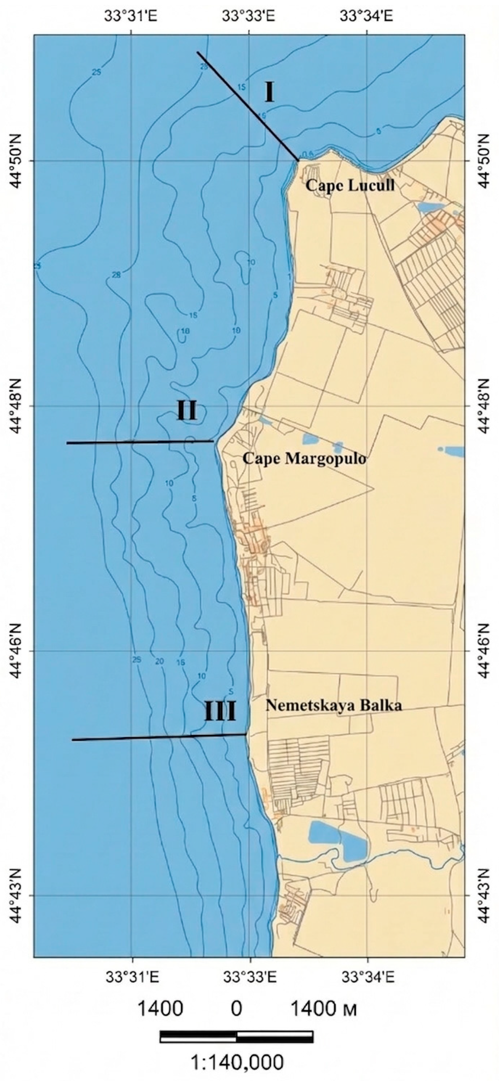
The study area is located along the western coast of Crimea, extending from Cape Lukull to the mouth of the Nemetskaya Balka ravine (
Figure 1). The coastline has a low degree of indentation and a generally submeridional orientation. This linear profile is interrupted by a series of capes. Nevertheless, the regularity of the shoreline is interrupted by capes formed on the basis of resistant-to-abrasion rocks—sandstones, gravelstones and conglomerates—which extend some distance seaward along the seabed [
53]. The most extensive and dense macrophytobenthic communities, with a projected bottom coverage of 80–90%, are concentrated on these rocky substrates associated with the capes.
The embayments between capes consist of mobile sand, gravel, and pebble sediments, which are devoid of benthic vegetation. In the studied water area, there are accumulations of randomly arranged plates and conglomerate blocks that form protrusions of the bottom and individual spots (banks). Algae are found on these solid inclusions. The contribution of these formations does not exceed 5–10% of the total area of the site.
Due to the specific geomorphology of the underwater terrain, hydrobotanical transects were established in the vicinity of prominent capes (
Figure 1). The length of each transects varied from the water’s edge to the lower depth limit of the photic phytobenthic zone (
Table 1).
The coastal zone within the study area is characterized by varied land-use types. Transect I, located at Cape Lukull, falls within the boundaries of a regionally designated natural monument, the “Coastal Aquatic Complex near Cape Lukull.” The coastline encompassing Transect II (Cape Margopulo) is subject to multifunctional use, including recreational, specialized, and water-management activities.
The shoreline area of Transect III, near Nemetskaya Balka, was characterized by relatively undisturbed natural coastal landscapes prior to 2018. Currently, this area has been severely altered by anthropogenic activity, primarily due to the extraction of sand and gravel deposits.
Climatic data were sourced from the global TerraClimate dataset [
54,
55], accessible via the Google Earth Engine [
56,
57] cloud platform under the asset ID IDAHO_EPSCOR/TERRACLIMATE. This dataset provides monthly values for climate variables and water balance components at a spatial resolution of approximately 4 km (1/24°) from 1958 to the present. For this analysis, we extracted monthly time series of minimum and maximum air temperature and precipitation. Since the observation points are included in one square of the data collection, only the temporary variability of the indicators was analyzed. The extracted time series were exported in CSV format for further processing. Data processing and the calculation of annual mean values were performed using the R software environment R Studio 3.51 (Posit Software, PBC, 250 Northern Avenue, Suite 410, Boston, MA 02210, USA).
Hydrobotanical studies were performed using light diving equipment and using small vessels in the summer of 2020. To assess macrophytobenthic composition, three transects were established (
Figure 1,
Table 1), and samples were collected according to standard methodology [
58]. To study the species composition and determine the biomass of macrophytes, quantitative samples were collected at depths of 0.5, 1, 3, 5, 10, and 15 m. At each depth, a white metal frame measuring 25 × 25 cm was placed four times on thickets typical for that depth in terms of density. The algae that fell within the boundaries of the frame were carefully cut or torn off by hand and placed in bags made of mill gauze. A label made of waterproof material, indicating the date, area, and depth of macrophyte collection, was placed in each bag. The percentage of the bottom covered by algae was visually estimated (as a percentage relative to the uncolonized part of the bottom), and the distribution pattern of the macrophytes was noted [
58]. To assess the quantitative characteristics of the macrophytobenthos, the biomass of individual species and the total biomass for all macrophytes collected at a specific station were taken into account. Individuals of each species were weighed after being blotted dry with filter paper. The results of weighing and recalculating the species that fell within the sampling frame were converted to an area of 1 m
2 of the bottom. Thus, 72 quantitative samples were collected. Their initial processing took place in the laboratory, where the species composition of the algae was determined using an "Armed XS-90" microscope (Armed company, Moscow, 143900, Russia). For species identification, an algal identification guide [
59] was used, and the results of recent nomenclatural revisions were taken into account [
60].
Identification keys [
59] were used to identify the taxa. The nomenclature and systematic position of the macroalgae are given according to AlgaeBase [
60], and the names of the taxon authors are given in standard abbreviation following the recommendations of the International Plant Names Index (IPNI) [
61].
The Macrophyte Stock Herbarium is located in the institution where the authors of the article currently work. The herbarium has about 30,000 specimens and about 800 species. The herbarium of macrophytes of the "World Ocean IBSS" is officially registered in the Index Herbariorum under the acronym SIBS and is available for work by specialists from various scientific institutions.
The structure of benthic communities was analyzed using the Shannon–Wiener diversity index (H’).
To evaluate long-term changes, data from hydrobotanical surveys conducted in the same area during the summers of 1964 and 2009 were included. These historical surveys followed analogous transects and methodology, enabling a direct comparative analysis of changes in species composition, quantitative characteristics, and distribution of macrophytobenthos over time. The 1964 data were obtained from the archive of the Institute of Biology of the Southern Seas. The 2009 data were provided by a co-author involved in the original sample collection and processing and were supplemented by published records [
58,
62]. For statistical analysis, mean values and standard errors were calculated for all relevant parameters.
3. Results
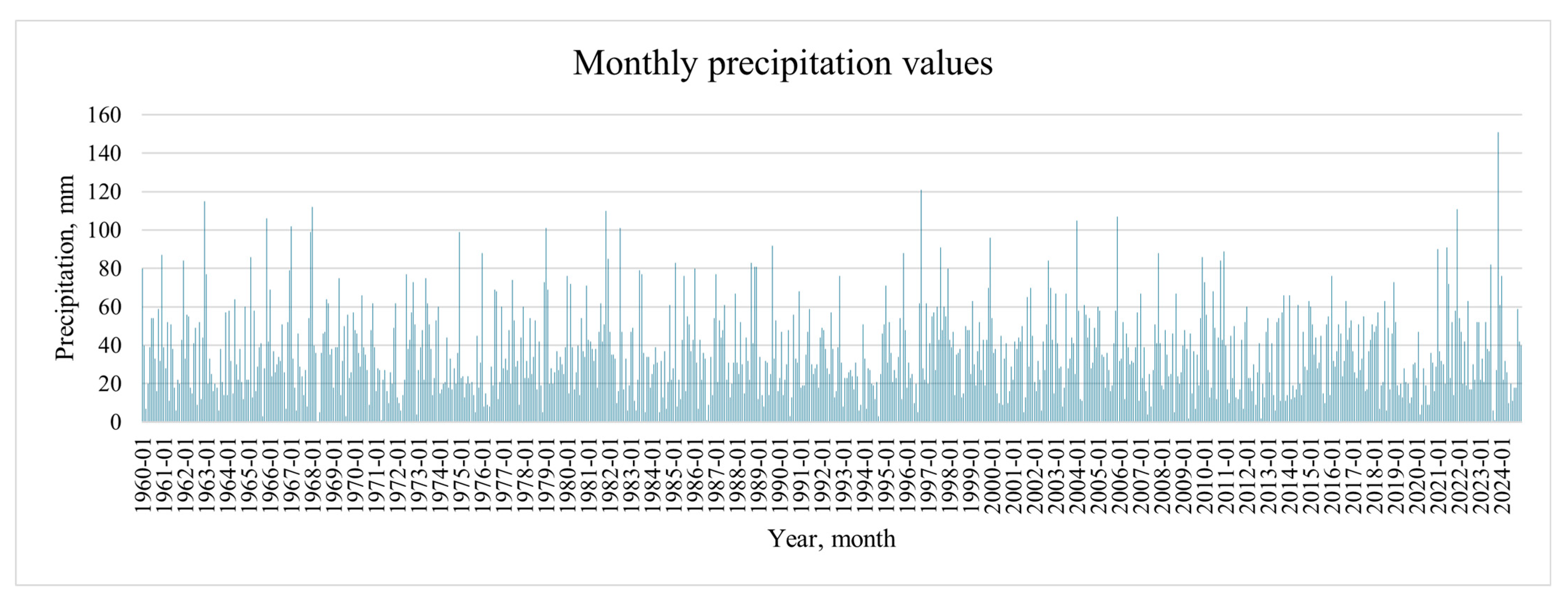
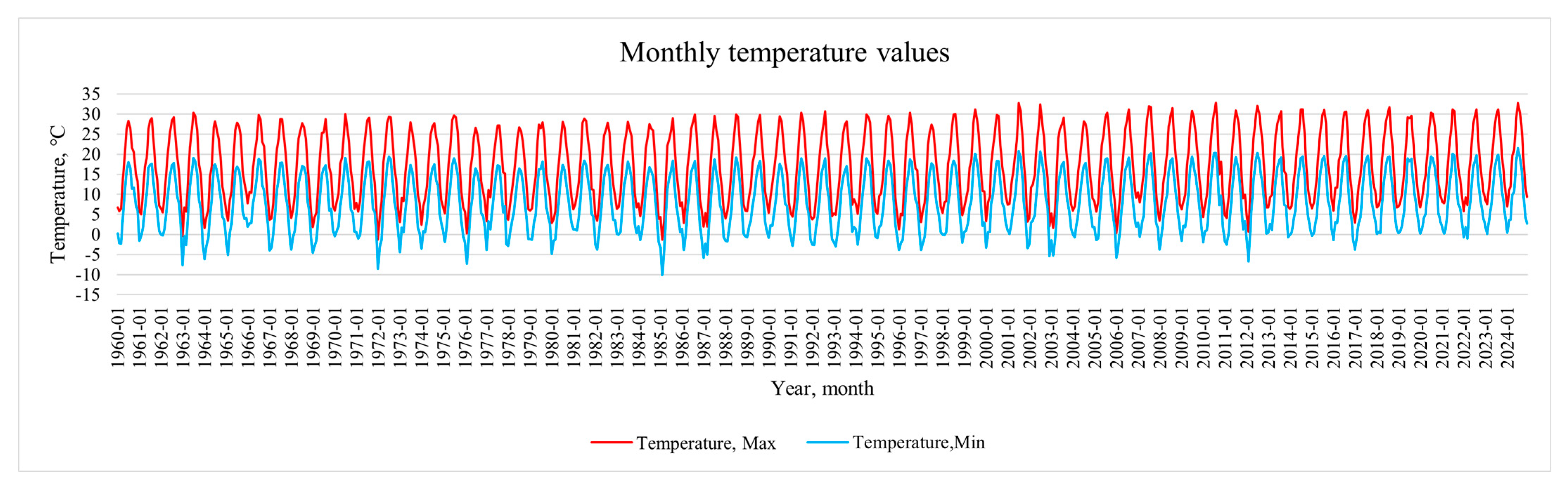
In the course of the work, the average values of the minimum and maximum monthly air temperature and precipitation on the studied coast were analyzed, shown in
Appendix A Figure A1 and
Figure A2.
Analysis of the temperature records reveals a clear trend of increasing temperature extremes. The most pronounced warming occurred during the summer months (June, July, August). For instance, the average maximum July temperature has risen by 3.5–4.5 °C. Furthermore, absolute maximum temperatures exceeding 32 °C, once rare anomalies at the beginning of the study period, have become systematically recorded in the last two decades. A similar, though slightly less intense, warming trend is evident in the cold season. The average minimum temperatures for January and February have increased by approximately 2.0–3.0 °C, leading to a marked decline in the frequency of temperatures falling below −10 °C.
Precipitation patterns show a tendency toward higher monthly totals during the warm season. In recent decades, monthly precipitation maxima for July, August, and September (e.g., in 2021 and 2023) have significantly exceeded historical norms.
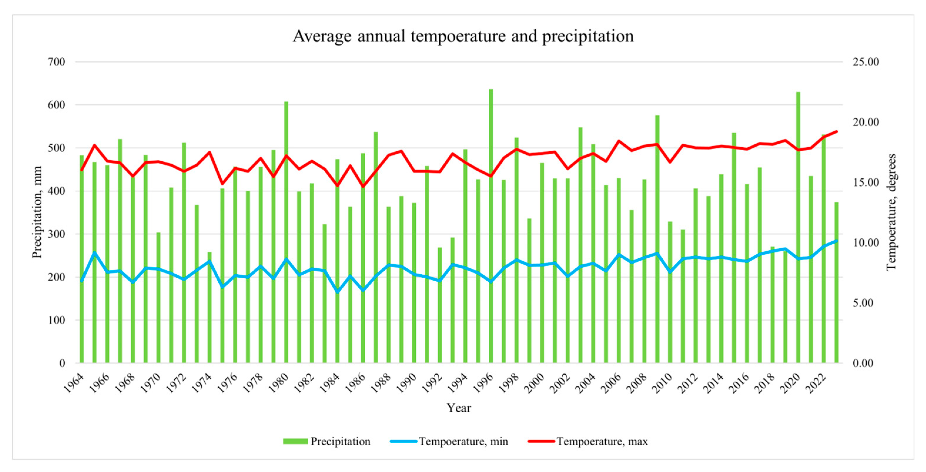
The annual mean values for minimum temperature, maximum temperature, and total precipitation are summarized in
Figure 2.
As illustrated in
Figure 2, a rise in temperature indices is evident against a backdrop of increasing interannual precipitation variability, a pattern consistent with global climate trends.
Over the 65-year observation period, the mean annual minimum temperature increased by 2.5–3.0 °C. The trend is particularly pronounced in recent years. While minimum temperatures in the 1960s fluctuated around 7.5 °C, they have consistently exceeded 9.0 °C in the 2020s, reaching an absolute maximum of 10.13 °C in 2024. An even more pronounced increase is observed for mean annual maximum temperatures, which have risen by approximately 3.5–4.0 °C. Values that rarely exceeded 17.0 °C in the first two decades of observations (1960–1979) systematically reached 18.0 °C and above in the most recent two decades (2005–2024), with a peak of 19.22 °C in 2024.
Analysis of the long-term precipitation series does not reveal a statistically significant directional linear trend in total annual precipitation, with the long-term average remaining relatively stable. However, the standard deviation of annual precipitation totals has increased markedly over the last three decades compared to the mid-20th century. The time series shows an alternation of drought years (e.g., 1971, 1975, 1993, 2019, 2020 with totals below 300 mm) and anomalously wet years (e.g., 1981, 1997, 2010, 2021 with totals exceeding 600 mm).
Based on field research and analysis of literature and archival materials, we characterized the composition, quantitative characteristics, distribution, and dominant algal species of the macrophytobenthos.
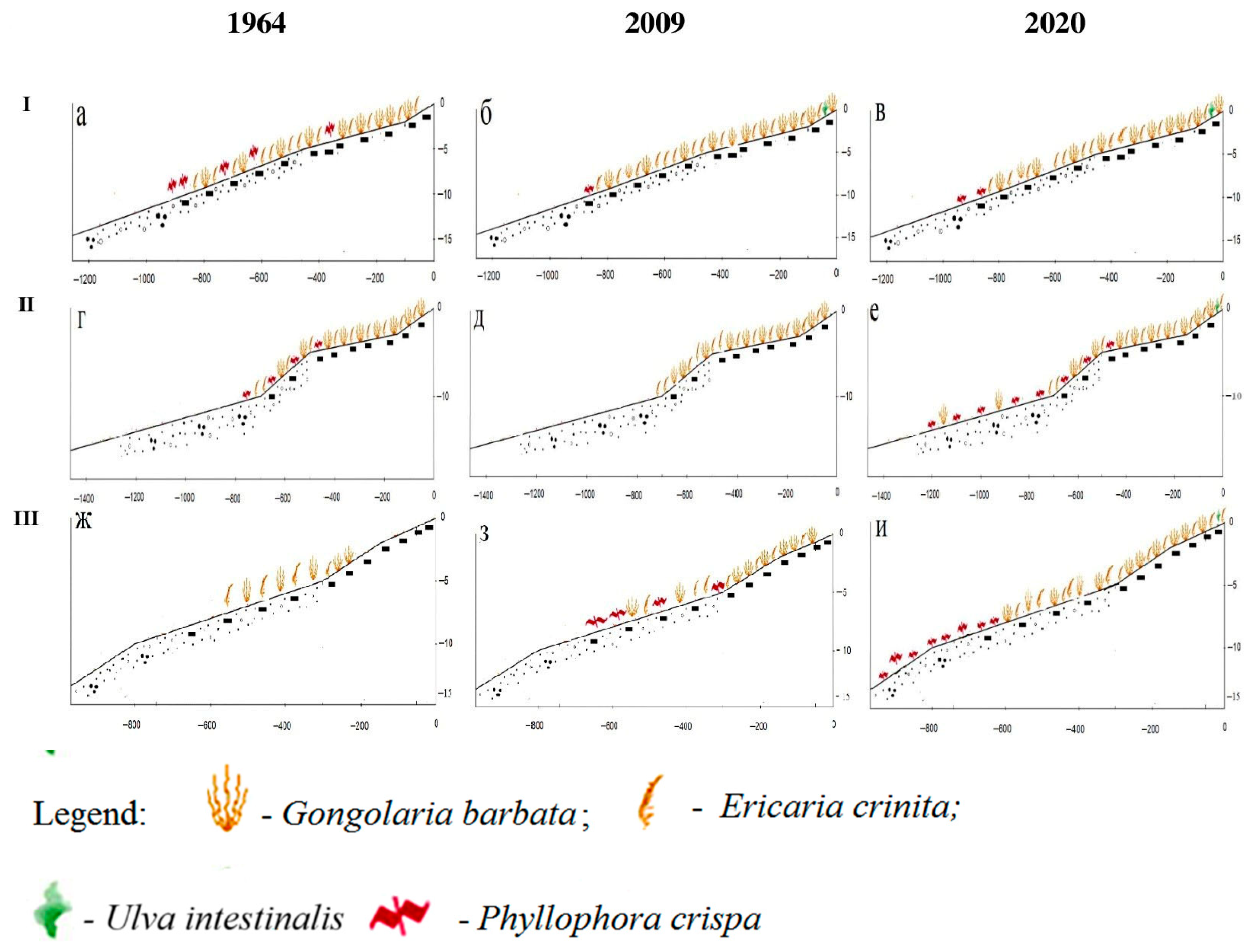
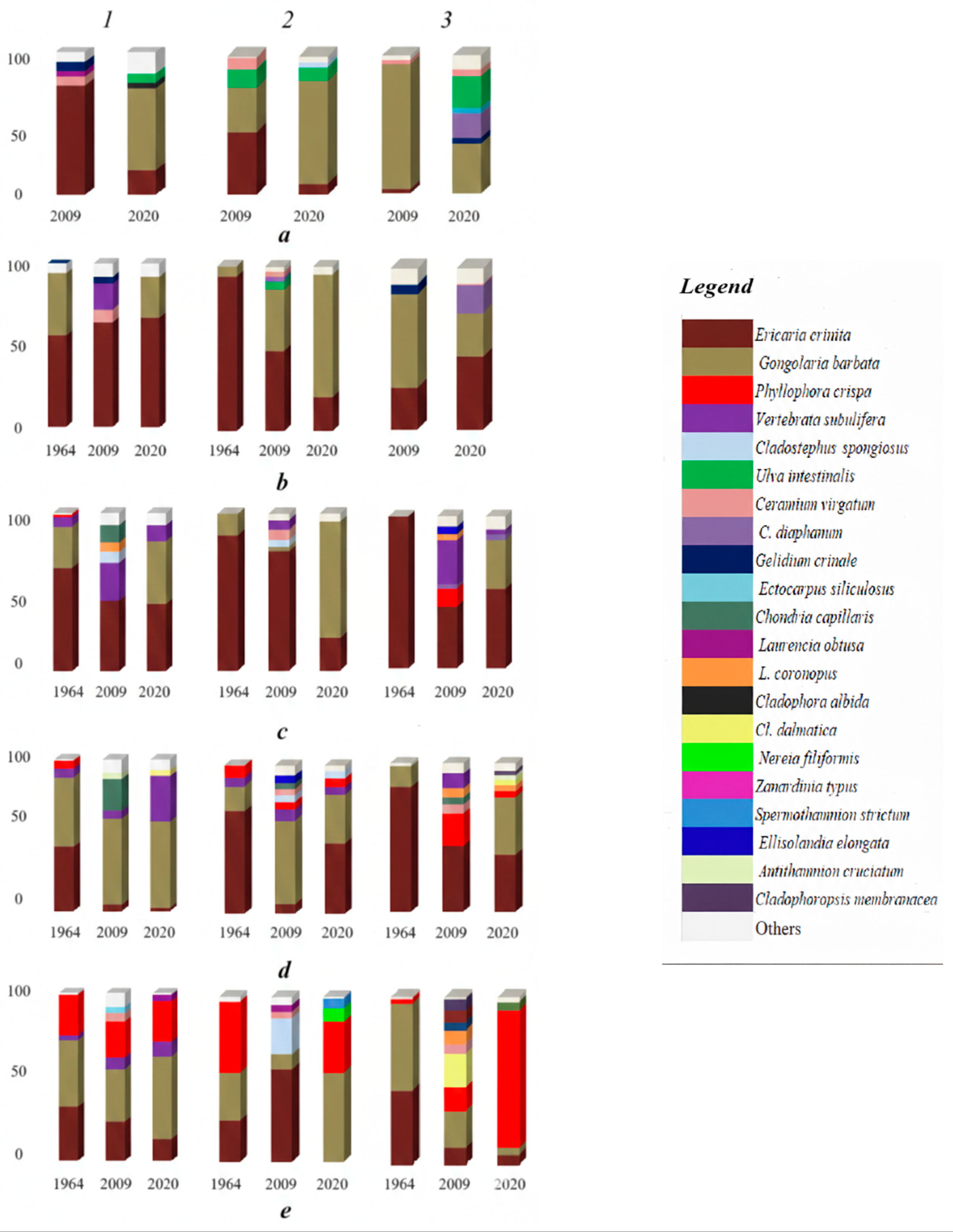
Figure 3 presents a schematic map of the hydrobotanical transects, constructed using bathymetric and lithological maps, and incorporates data from underwater surveys conducted in 1964, 2009, and 2020, accounting for the distribution of dominant macroalgal species.
3.1. Distribution of Benthic Vegetation in 1964
Over half a century ago, macrophytobenthos along Transects I and II was recorded within a depth range of 1–10 m, while on Transect III it occurred at depths of 3–10 m (
Figure 4).
3.1.1. Transect I (Cape Lukull)
In the 1960s, the maximum macroalgal biomass at this site was recorded at a depth of 3 m (
Table 2). Notably, biomass values at 1 m were comparable to those at 3 m, whereas values declined by nearly half with increasing depth from 5 to 10 m (
Table 2). Dominant species
Ericaria crinita (Duby) Molinari & Guiry (=
Cystoseira crinita) and
Gongolaria barbata (Stackhouse) Kuntze (=
Cystoseira barbata)) accounted for a high proportion of total biomass across all sampled depths, with a maximum contribution at 1 m and a minimum at 10 m (
Table 2). The community also included
Phyllophora crispa (Huds.) P.S. Dixon, whose relative contribution increased with depth from 0% to 24% of total macroalgal biomass (
Figure 4). Epiphytic algae were poorly represented (
Table 2), with only
Vertebrata subulifera (C. Ag.) Kuntz and members of the genus
Ceramium observed (
Figure 4).
3.1.2. Transect II (Cape Margopulo)
The total biomass of macrophytobenthos increased with depth from 1 to 5 m, rising from 4030.0 ± 366.5 to 5375.0 ± 467.4 g·m
−2, before slightly decreasing at 10 m. The relative contribution of the dominant species (
E. crinita and
G. barbata) progressively declined with depth from 100% to 54%. Concurrently, the proportion of
Ph. crispa, which was found only at 5 and 10 m, increased more than fivefold, from 8% to 43% of the total macroalgal biomass (
Table 2,
Figure 4). Epiphytes, represented solely by
V. subulifera, were recorded exclusively at a depth of 5 m (
Figure 4).
3.1.3. Transect III (Cape at Nemetskaya Balka)
Benthic vegetation at this site was found only at depths of 3 m and greater. The highest total macrophytobenthic biomass was recorded at 5 m, with slightly lower values at 3 m and a nearly twofold reduction at 10 m (
Table 2). The dominant species (
E. crinita and
G. barbata) comprised a consistently high proportion (97–100%) of the total biomass across all depths. Within the community, minor aggregations of
Ph. crispa were noted only at 10 m (
Figure 4). An epiphytic synusia was virtually absent at all depths (
Table 2).
Across all transects, the benthic vegetation in 1964 was dominated by
E. crinita and
G. barbata, with accompanying algal species playing a minor role. The macrophytobenthos was characterized by a low prevalence of epiphytes. The relatively low values of the Shannon diversity index recorded at all sites indicate homogeneous community structures dominated by a few key species (
Table 2).
3.2. Distribution of Benthic Vegetation in 2009
It is significant that after 45 years, macrophytobenthos in all sections was recorded at a depth of 0.5 to 10 m. (
Figure 3).
3.2.1. Transect I (Cape Lukull)
In section I in the early 2000s, the total biomass of macrophytobenthos decreased 5-fold with increasing depth, while its maximum value was noted at a depth of 0.5 m, and the minimum value was at a depth of 10 m. Biomass values at intermediate depths (1–5 m) were comparable, varying within a narrow range (
Table 2). The community remained dominated by
E. crinita and
G. barbata across all depths. Their contribution was highest at 0.5 m, declined by approximately half by 3 m, and then increased slightly with further increases in depth (
Table 2). Aggregations of
Ph. crispa were found only at 10 m, where it constituted 21% of the total macroalgal biomass. The community also included
Cladostephus spongiosus (Huds.) C. Ag.,
Ulva intestinalis L., and members of the genus
Gelidium (
Figure 4).
A notable shift in 2009 was the substantial contribution of epiphytes at this transect, with peak values recorded at 3 m and 5 m (47% and 36% of total biomass, respectively;
Table 2). The epiphytic assemblage at all depths included
V. subulifera and
Ceramium virgatum Roth., while
Chondria capillaris (Huds.) M. J. Wynne was predominant at 5 m and 10 m (
Figure 4). Additional epiphytic species recorded were
Laurencia coronopus J. Ag.,
Ectocarpus siliculosus (Dillwyn) Lyngb.,
Antithamnion cruciatum (C. Ag.) Nägeli (
Figure 4).
3.2.2. Transect II (Cape Margopulo)
Total macrophytobenthic biomass at this site exhibited wide variation, decreasing nineteenfold across the sampled depth gradient (
Table 2). The community was dominated by
E. crinita and
G. barbata at all depths, accounting for 61% to 86% of total biomass.
Ph. crispa was present only at 5 m, where its contribution did not exceed 5% (
Figure 4).
U. intestinalis was abundant at 0.5 m (13% of biomass), but its contribution diminished to 1% by 3 m (
Figure 4). In contrast, the proportion of
Cl. spongiosus increased from 5 m onwards, ranging from 5% to 22% of total biomass.
The epiphytic synusia made a considerable contribution, constituting 9–22% of total macroalgal biomass. The epiphytic assemblage was dominated by
C. virgatum, with additional occurrences of
Ceramium diaphanum (Lightf.) Roth.,
V. subulifera,
Ch. capillaris,
Laurencia obtusa (Huds.) J. V. and
Stilophora tenella (Esper) P. C. Silva (
Figure 4).
3.2.3. Transect III (Cape at Nemetskaya Balka)
Maximum macrophytobenthic biomass was recorded at 3 m, with values at 0.5–1 m and 5 m being threefold and twofold lower, respectively (
Table 2). Notably, benthic vegetation was nearly absent at 10 m, resulting in extremely low total biomass at this depth (
Table 2). The proportion of dominant species (
E. crinita and
G. barbata) remained high (85–97%) at shallow depths (0.5–1 m) but decreased by more than half at depths of 3 m, 5 m, and 10 m (
Table 2).
Ph. crispa was present between 3 and 10 m, with its maximum contribution (22% of total biomass) occurring at 5 m (
Figure 4). The community composition also included
Gelidium crinale (Hare ex Turner) Gaillon.,
Cl. spongiosus,
Ellisolandia elongata (J. Ellis & Solander) K.R. Hind & G.W. Saunders,
Cladophoropsis membranacea (Hofm. Bang ex C. Ag.) (
Figure 4).
Epiphytic contribution exhibited considerable depth-dependent variation, ranging from a maximum of 37% at 3 m to a minimum of 1% at 0.5 m (
Table 2). Within this epiphytic assemblage,
V. subulifera dominated at 3 m, but its relative abundance declined fourfold with increasing depth. In contrast,
Cladophora dalmatica Kütz. was the predominant epiphyte at 10 m (
Figure 4). Other recorded epiphytic algae included
C. virgatum, L. coronopus,
L. obtusa,
Ch. capillaris.Collectively, the 2009 data indicate a clear transition in community structure across all transects. Total macroalgal biomass increased relative to 1964, a change primarily attributable to greater contributions from associated algal species and a pronounced rise in epiphytic biomass. This shift coincided with a marked decline in the proportional dominance of
E. crinita and
G. barbata. The concurrent increase in Shannon diversity index values across all sites reflects these structural changes, indicating more complex communities with a significant epiphytic component (
Table 2).
3.3. Distribution of Benthic Vegetation in 2020
3.3.1. Transect I (Cape Lukull)
In 2020, macrophytobenthos was recorded at depths from 0.5 to 10 m on Transect I, while on Transects II and III it extended to 15 m (
Figure 3). At this site, maximum macroalgal biomass occurred at 1 m, with values decreasing by half from 3 to 10 m (
Table 2). The contribution of the dominant species (
E. crinita and
G. barbata) was consistently high across all depths, with only minor fluctuations. Their greatest proportion was also recorded at 1 m, and the lowest at 5 m (
Table 2). Aggregations of
Ph. crispa were found exclusively at 10 m (
Figure 4). The community at 0.5 m included green algal species (
U. intestinalis and
Cladophora albida (Nees) Kütz.) (
Figure 4). The epiphytic synusia was composed primarily of
V. subulifera, which reached a maximum contribution of 30% of total macroalgal biomass at 5 m (
Figure 4). Additional epiphytes recorded were
Polysiphonia opaca (C. Ag.) Moris et De Notaris and members of the genus
Ceramium at 0.5–1 m, and species of the genus
Laurencia and
Shacelaria cirrhosa (Roth) C. Ag. at depths of 3–10 m.
3.3.2. Transect II (Cape Margopulo)
Total macrophytobenthic biomass exhibited considerable variation, ranging from 11542.8 ± 678.1 to 1730.4 ± 201.1 g·m
−2, with a maximum at 1 m and a minimum at 15 m (
Table 2). The proportion of
E. crinita and
G. barbata was highest (80–95%) at depths of 0.5–5 m, but declined to 54–21% of total biomass with further depth increases (10–15 m) (
Table 2). Dense aggregations of
Ph. crispa were recorded primarily at 10–15 m (
Figure 4). Notably, the plant community at 0.5 m included
U. intestinalis and
Cl. albida; at 5 m,
Cl. spongiosus was present; and the deeper zones (10–15 m) featured the deep-water species
Nereia filiformis (J. Ag.) Zanard. and
Zanardinia typus (Nardo) P. C. Silva.
The epiphytic contribution was negligible (1–7%) from 0.5 to 10 m but increased to 15% of total biomass at 15 m, where it was predominantly composed of
Spermothamnion strictum (C. Ag.) (
Table 2,
Figure 4).
3.3.3. Transect III (Cape at Nemetskaya Balka)
Total macrophytobenthic biomass increased eightfold from 0.5 to 1 m, reaching its maximum at the latter depth; the minimum biomass was recorded at 15 m (
Table 2). The proportion of
E. crinita and
G. barbata was high (75–84%) at depths of 1–5 m. Their contribution was more than twofold lower at 0.5 m, and decreased markedly to 3–10% of total biomass at depths of 10–15 m. At these greater depths (10–15 m),
Ph. crispa dominated, constituting 82–90% of the total macroalgal biomass (
Figure 4). The benthic vegetation at 0.5 m was characterized by an abundance of lithophytic forms, primarily
U. intestinalis and
C. diaphanum, Cl. spongiosus was found at deeper stations (
Figure 4). The epiphytic assemblage was dominated by species of the genus
Ceramium at 0.5–1 m, by
V. subulifera and
L. obtusa at 3–5 m, and by
S. strictum and
A. cruciatum at 10–15 m.
Total macroalgal biomass in 2020 exceeded that recorded in 1964 and was broadly similar to 2009 values. The proportional biomass of
E. crinita and
G. barbata showed an increase relative to 2009, although it did not fully return to the dominance levels characteristic of the 1964 assemblage. More importantly, epiphyte contribution decreased across most transects between 2009 and 2020, yet remained above the minimum values documented in the 1964 baseline. Shannon diversity indices reveal a consistent trend across all transects toward a polydominant community configuration, with a prominent role for both accompanying macrophyte species and epiphytic forms (
Table 2).
4. Discussion
In the mid-1960s, when anthropogenic pressure in this coastal zone was minimal, the macrophytobenthos across all transects was in a natural or near-natural state. Its composition, structure, and productivity corresponded to conditions typical of “clean” marine areas [
62]. For instance, in 1964, total macrophytobenthic biomass at a depth of 3 m ranged from 2820.0 ± 149.9 to 4717.0 ± 504.4 g·m
−2, with the maximum recorded at Transect II (a comparable value of 5320.0 ± 411.2 g·m
−2 was observed at Transect I) and the minimum at Transect III (
Table 2;
Figure 3). The lower biomass at Transect III can be attributed to the absence of benthic vegetation at depths shallower than 3 m. During this period, the distribution of benthic vegetation was governed principally by the attenuation of light with depth, which manifested as shifts in species composition and a decline in quantitative metrics.
An indirect indicator of increased trophic status in the coastal zone of western Sevastopol over the study period is provided by the Shannon diversity index. This index was minimal in 1964 (range: 0–1.75), increased substantially in 2009 (0.45–3.13), and remained elevated in 2020 (0.66–2.96) (
Table 2). This trend is consistent with the documented response of macroalgal communities to nutrient enrichment, where total biomass increases are driven primarily by associated and epiphytic species [
63].
Late 20th-century coastal development—including campgrounds, resorts, and hotel complexes—intensified marine pollution. On the Crimean shelf of the Black Sea, wastewater discharge is the primary driver of coastal eutrophication. At Transect I, elevated phosphorus and BOD
5 levels reflect inputs from a nearby sewer main near Andreyevka; treatment facilities similarly affect Transect II [
64,
65]. Additional anthropogenic pressure along Sevastopol’s western coast comes from the Kacha and Belbek rivers, which drain intensively farmed areas [
66,
67] and deliver high loads of nutrients, suspended solids, and organic matter—contributing to elevated BOD
5, metals, and petroleum hydrocarbons [
65].
In 2020, total macrophyte biomass at 1 m depth was roughly 2–3 times higher in sections I and II than in 2009 and 1964, respectively; in section III, it was 14 times higher than in 2009 (
Table 2).
Over the study period, the proportional contribution of the key algal species (
E. crinita and
G. barbata) declined across all investigated transects. In 1964, at depths of 1–10 m, these species together accounted for 100% to 54% of total macrophytobenthic biomass. By 2009, their contribution within the same depth range had decreased to between 97% and 32%, and by 2020, it ranged from 95% to just 10%. Across transects, the decline was most pronounced at Transect III, where the proportion of
E. crinita and
G. barbata fell from 100 to 54% in 1964 to 10% in 2020. In contrast, the decrease was less severe at Transects I and II, where their contribution remained relatively high throughout the study period, ranging from 94 to 55% and 100–54%, respectively (
Table 2). The most substantial negative change occurred at Transect III, where terracing of the coastal zone for a planned cottage settlement was noted, suggesting a link between coastal modification and the decline in these dominant macrophytes.
A similar benthic community shift occurred in the Mediterranean. Near Marseille, studies on sewage discharge impacts revealed an increase in algal taxa near outfalls between 1972–1974 and 1995–1996, with the sublittoral zone becoming dominated by ephemeral algae and deeper
Cystoseira stands disappearing [
13].
Long-term studies of macrophytobenthos in the coastal zone of Alberes in the northwestern Mediterranean have also shown that since the late 19th century, many macrophyte species previously considered common have not been recorded, and some were once dominant within phytobenthic communities. The work noted that since the 1940s, populations of species from the genus
Cystoseira—including
Cystoseira crinita and
C. barbata—have experienced a steady decline [
14].
Some authors explain the degradation of thickets of species of this genus by the destruction of their habitat, household pollution of the aquatic environment and anthropogenic impact [
12,
14].
Similar changes in benthic vegetation composition and structure were documented in long-term studies off the coast of Greece in the eastern Mediterranean [
68]. Despite the commissioning of advanced wastewater treatment plants, a decline in “clean-water”
Cystoseira species occurred far from the pollution source. Meanwhile, near the former outfall, green algae (
Ulva,
Cladophora) decreased significantly and species diversity increased. The authors attribute the
Cystoseira decline primarily to shoreline modification from coastal protection works and recreational construction, which have destroyed extensive macrophyte habitats, as well as to increased populations of sea urchins and invasive herbivorous fish (
Siganus spp.) [
68]. In the Black Sea, however, low salinity excludes sea urchins, and invasive species remain negligible; thus, these factors likely have little impact. The main driver of macrophytobenthos composition and structure there is likely intensifying anthropogenic pressure in the coastal zone.
The elevated eutrophic conditions, likely resulting from uncontrolled recreational pressure and insufficient sewage treatment, are also reflected in the contemporary community composition. At shallow depths (0.5–1 m) across all transects in 2020, there was a markedly higher proportion of lithophytic, opportunistic taxa from the genera
Ulva and
Ceramium compared to 2009 and especially 1964 (
Figure 4). These algae are known to thrive in nutrient-enriched waters [
62,
65]. Thus, at a depth of 0.5 m in 2020, their share in section I was 6%, in section II—9%, and in section III—23% of the total biomass of macrophytes.
A notable shift was observed at the lower photic boundary (10 m depth) in the relative contributions of light-demanding (E. crinita, G. barbata) and shade-tolerant (Ph. crispa) species to total biomass over time, a change likely associated with reduced water transparency.
While the proportional biomass of these species at 10 m remained relatively stable throughout the study period at Transects I and II, a dramatic shift occurred at Transect III. Here, the combined contribution of
E. crinita and
G. barbata decreased by nearly an order of magnitude, while the proportion of the deep-water species
Ph. crispa increased from 3% (1964) to 82% (2020) (
Table 2,
Figure 4).
This pronounced transformation of the macrophytobenthic community at Transect III may be attributed to local factors exacerbating turbidity. In addition to intensive coastal development, the area hosts a shellfish farm, the operation of which likely contributes to increased suspended solids. The observed reduction in water clarity is further supported by the presence in 2020 of typically deep-water species (
Z. typus and
N. filiformis) at depths of 10–15 m, whereas their historical range in the 1960s-70s was below 25 m [
62].
A similar causal mechanism has been proposed by researchers working in the coastal waters of Alberes (northwestern Mediterranean Sea), who attribute the decline in deep-water macrophyte populations to two primary factors: increased water turbidity and mechanical damage from net fishing activities [
14].
Over fifty years ago, epiphytic algae were poorly represented across all transects, with the assemblage dominated by
V. subulifera and members of the genera
Ceramium and
Laurencia (
Figure 4). Notably, green algal species typically associated with organically polluted waters were absent at depths of 1–10 m. Between 1964 and 2020, the proportional contribution of the epiphytic synusia increased substantially (
Table 2). By 2020, the epiphytic biomass at depths of 5–10 m had risen by 6 to 12-fold compared to 1964 levels (
Table 2). The most pronounced epiphytic development, accompanied by a suppression of dominant foundational species, was observed at Transect III. The epiphytic community here included, in addition to green algae, polysaprobic species such as
Callithamnion corymbosum (Smith) Lyngb. and
C. virgatum, which thrive in nutrient-rich waters (
Figure 4).
A statistically significant correlation exists between regional climatic trends and structural changes in macrophytobenthos along the western Crimean coast. Sustained summer warming—average July–August temperatures have risen by 3.5–4.5 °C since the 1960s—appears to drive key community metrics, including increased total macroalgal biomass, depth-stratified shifts in species dominance, and altered trophic structure. Productivity data show substantial biomass increases at most stations and depths between 2009 and 2020 (e.g., from 3953.7 to 7170.4 g·m
−2 at 1 m on Transect I, and from 618.0 to 8802.8 g·m
−2 at 1 m on Transect III). These gains are most pronounced in the upper and middle sublittoral zones (1–5 m), consistent with surface-layer warming. By 2020, the largest positive increments occurred at 1–3 m depth—the stratum with the greatest temperature increase—while biomass trends at 10 m varied across transects (
Table 2).
The marked increase in pollutant loading from diverse discharges into the study area over recent decades has, consequently, resulted in significant alterations to the composition and quantitative parameters of the macrophytobenthos. The high proportional representation of epiphytic algae within the community is interpreted as a direct biological response to nutrient enrichment and the associated increase in trophic status. Epiphytes possess a higher growth rate and greater specific thallus surface area for nutrient absorption compared to slower-growing species such as
E. crinita,
G. barbata, and
Ph. crispa [
69], providing them with a competitive advantage in nutrient-enriched waters.
Algological studies conducted along the coast of Barcelona have shown that there is a gradient in macrophytobenthos communities living in the upper sublittoral zone: from dense thickets of species of the genus
Cystoseira, which are found on the northern coast, where tourism is the main economic resource of the area, to communities with a predominance of green algae growing near the metropolitan area with a high population and industrial development [
19].
Currently, along the Romanian coast of the Black Sea, due to an increase in the degree of pollution of water masses, the main components of algal communities are species of the genus
Ulva, with
U. rigida and
U. intestinalis dominating [
20].
A notable finding of this study is the observation of convergent trends in benthic vegetation change across all transects on the western Crimean coast. This convergence occurred despite contrasting land-use designations: Transect I is situated within the “Coastal Aquatic Complex near Cape Lukull”, a designated natural monument with a formal conservation mandate, whereas Transects II and III are subject to multifunctional use, encompassing agricultural, horticultural, and military activities. The observed parallelism in ecological trajectory suggests that the protected area may be too limited in spatial extent and too isolated to effectively mitigate the impact of region-wide anthropogenic pressures.
The benthic vegetation across the study area nevertheless exhibits a high degree of ecological integrity, underscoring its considerable conservation value. Multiple macroalgal species listed in various Red Data Books were recorded, including
Ericaria crinita (Duby) Molinari & Guiry and
Gongolaria barbata (Stackhouse) Kuntze (Red Book of the Republic of Crimea (2015), Red Book of the Black Sea (1997, 1999)),
Laurencia coronopus J. Ag.,
Osmundea pinnatifida (Huds.) Stackhouse,
Osmundea hybrida (A.P. de Candolle) K.W. Nam (Red Book of the Republic of Crimea),
Nereia filiformis (J. Ag.) Zanard. (Red Book of the Republic of Crimea, Red Book of Sevastopol (2018)),
Laurencia obtusa (Huds.) J. V. Lamour.,
Gelidium spinosum (S.G. Gmel.) P.C. Silva,
Ulvella viridis (Reinke) R. Nielsen, O’Kelly et B. Wysor (Red Book of the Black Sea (1997)),
Stilophora tenella (Esper) P.C. Silva (Red Book of the Russian Federation (2024), Red Book of the Republic of Crimea, Red Book of Sevastopol),
Phyllophora crispa (Huds.) P.S. Dixon (Red Book of the Russian Federation, Red Book of the Republic of Crimea, Red Book of Sevastopol, Red Book of the Black Sea (1997, 1999) [
70,
71,
72,
73].
Long-term monitoring of the macrophytobenthos on the western Crimean coast, including its floristic composition, production parameters, and spatial distribution, shows that the benthic vegetation remains in a relatively undisturbed state. This stability highlights its high conservation value and the need for continued protection [
74]. The absence of significant interannual fluctuations in qualitative and quantitative community metrics indicates that the benthic vegetation is developing under relatively stable environmental conditions, with no major shifts in habitat characteristics so far [
75]. Against the background of accelerating global degradation of coastal marine ecosystems, there is an urgent need for conservation and restoration measures, which is reflected in the growing number of international programs aimed at these goals [
42,
76,
77]. At the same time, macrophytobenthos-monitoring programs differ considerably in design and objectives across regions. In Europe, EU directives have driven the development of harmonized assessment protocols, making systematic monitoring of macroalgal communities and mapping of macrophyte habitats key components in evaluating the ecological quality of coastal waters [
24]. The authors emphasize the necessity of harmonizing and standardizing long-term studies of marine macroalgae through common indicators, unified sampling designs, and standardized field measurement protocols to ensure data comparability.