Abstract
Documenting and preserving cultural heritage assets is increasingly important, with threats from natural disasters, conflicts, climate change, and neglect, and some sites are both contested and physically difficult to access or document, posing the issue of “challenging heritage”. A range of innovative digital methods have emerged, offering practical, low-cost, efficient techniques for the 3D documentation of threatened heritage, including smart phone-based mobile light detection and ranging (LiDAR) and photogrammetry. Such techniques offer quick, accessible, and cost-effective alternatives to terrestrial laser scanners, albeit with reduced accuracy and detail, offering practical solutions in cases with restricted funding, limited time for access, complex architectural geometries, or the unavailability of high-end equipment on site. This paper presents a real-world case study integrating iPhone LiDAR with aerial photogrammetry for the rapid documentation of Sourp Magar Monastery, a Medieval site located in a forested slopes of the Kyrenia Range, Cyprus. Due to its poor state of preservation and years of abandonment, as well as its remote nature and location, the monastery is considered a “challenging heritage” monument. In the context of a recent international restoration initiative, a preliminary digital survey was undertaken to both document the current condition of Sourp Magar and contribute to a better understanding of its construction history. This paper outlines the workflow integrating the use of smartphone LiDAR and aerial photogrammetry, evaluates its efficacy in challenging heritage sites, and discusses its potential implications for rapid, low-cost documentation. Finally, the present paper aims to show the multifaceted benefit of easy-to-use, low-cost technologies in the preliminary study of sites and monuments.
1. Introduction
1.1. Digital Documentation of Cultural Heritage
Documenting cultural heritage sites through digital means has become increasingly standardized in the past two decades, with a wide range of methods now adopted for different contexts and scales. Among these, terrestrial laser scanning (TLS) remains the benchmark for high-precision documentation, providing dense point clouds with millimetric accuracy, though requiring expensive equipment and logistical planning [1,2]. Structure-from-motion (SfM) photogrammetry, especially from unmanned aerial vehicle (UAV) platforms (i.e., drones), offers a flexible and cost-effective method for 3D modeling of large sites and landscapes [3]. More recently, mobile mapping systems, including those equipped with “simultaneous localization and mapping,” have enabled documentation in heritage sites by integrating movement tracking with depth sensing [4]. These methods have become widely adopted in heritage studies, each offering trade-offs between precision, accessibility, and cost. Against this backdrop, a growing body of literature has begun to explore the potential of smartphone-integrated light detection and ranging (LiDAR) systems as a low-cost and practical solution, particularly for preliminary documentation in inaccessible or under-resourced contexts [5,6,7].
Mobile LiDAR technology is commonly found nowadays embedded in devices such as in iPhones or iPads, and it can be used for cultural heritage documentation. Mobile LiDAR offers a quick, accessible, and cost-effective alternative to professional TLS, although this entails a trade-off that offers practical expediency with reduced accuracy and detail [5,8]. Several challenges, such as sensor noise, and hardware limitations, affect the quality and precision of data obtained with mobile LiDAR. These limitations mean that smartphone-based systems do not always meet the stringent accuracy requirements of high-precision heritage documentation [6,9,10]. As a result, mobile LiDAR is best suited for rapid and preliminary surveys, where ease of use, portability, and low cost are prioritized over high precision, making it particularly valuable for emergency documentation or initial site assessments when time, accessibility, or budget constraints limit the feasibility of more advanced techniques [9,11].
With such growing interest in mobile LiDAR technology in the literature, it is particularly useful to assess its application and efficiency in the field, with a view to supporting its actual use in real heritage conservation applications. The application of the method can and needs to be optimized through systematic application and experimentation in real-world examples, going beyond one object or monument and dealing with a case study outside the lab-controlled environment. It is particularly important to work with sites and monuments located in difficult-to-access landscapes, with funding, time and permission limitations. These are exactly the conditions where the combined approach of mobile LiDAR and airborne photogrammetry can offer quite a reliable way to approach the challenges at hand.
This paper critically assesses the integration of smartphone-based LiDAR with aerial photogrammetry through a case study at the Sourp Magar Monastery in Cyprus (hereinafter “SMM”). The resulting digital model of the SMM offers an instructive and practical example of the integration of iPhone LiDAR data in a digital survey beyond the evaluation and comparison with other methods of digitization approaches that predominate in related literature. It is also applied to answer key research questions within a broader project on the history of the monastery. This paper critically evaluates the scientific and societal impact of this low-cost documentation approach, from model creation to dissemination, highlighting its applicability to remote and challenging sites. In doing so, the digitizing work of the project also aligns with recent European efforts in digital heritage and the open cloud environment for European Digital Heritage, as in the case of the ECHOES project (The ECHOES project: https://www.echoes-eccch.eu (accessed on 7 September 2025)).
1.2. The Concept of “Challenging Heritage”
The main aim of the paper is to outline and discuss the use of low-cost smartphone-integrated LiDAR and aerial photogrammetry documentation in a real-world example of “challenging heritage,” and it is important to address the definition of the term at the outset. “Challenging heritage” goes beyond the general notion of “difficult heritage”; while intersecting with the latter, challenging heritage also specifically addresses the physical challenges posed by the natural setting and the related limitations in access, which can be considered as being defining factors in the documentation of heritage studies [12]. To define the more familiar concept of “difficult heritage,” one of the most widely used terms in the field, Sharon Macdonald explains the term as a past that is acknowledged as meaningful yet which remains troubling, contested, and resistant to integration into positive or self-affirming narratives of collective identity [13]. This refers to heritage assets associated with past events or historical periods that a society struggles to reconcile with its positive self-image.
Such associations may be embodied in a place, object, or any reminder of that historical event, and are often shaped not only by national narratives, but also by the experiences of minorities and the surrounding landscape. Alongside this, alternative concepts had already existed in the field. For example, Tunbridge and Ashworth introduced the term “dissonant heritage,” which emphasizes that heritage is often contested; what one group (typically, though not exclusively, an ethnic group) sees as heritage, another might see as disinheritance [14]. Similarly, archaeologist Lynn Meskell introduced the term “negative heritage,” referring to places tied to conflict, trauma, or collective memory wounds, often described as “heritage that hurts” or, in tourism discourse, “dark heritage,” all of which pertain to sites of tragedy or death that present interpretive challenges, whether for professional scholars or cultural and tourism heritage management [15].
In general, these terms highlight heritage and historical narratives that are particularly difficult for communities to engage with. However, the concept of challenging heritage is not about creating an opposition to or an alternative for these terms. Instead, it seeks to incorporate them while taking a step further, by addressing logistic and environmental challenges as well. It thus serves as an attempt to unify these various dimensions within a single conceptual framework, particularly when considering landscapes such as the dense forests and rugged terrain surrounding the case study from the Kyrenia mountains in Cyprus. In this context, the case of SMM is evaluated in this study within the broader landscape in which it is integrated, with consideration of the particular conditions of limited access to the site. It can therefore be described as “challenging heritage,” combining cultural aspects of “difficult heritage” and issues of logistically inaccessible heritage in a challenging environment.
It is important to also address the concept of challenging environments. Here, physical accessibility and/or, inaccessibility are critical factors in heritage studies and related efforts for documentation and digitization. However, this inaccessibility is not limited to physical barriers alone; it is also closely tied to the difficulties imposed by natural conditions. These challenges affect both preservation and study of cultural heritage. This challenging aspect could be expanded as physically extreme or inhospitable terrains, such as remote mountain monasteries, desert ruins, or polar archaeological sites, as well as heritage threatened by climate change and environmental degradation [16,17]. Scholars and international organizations are increasingly recognizing climate change as one of the most significant emerging threats to both tangible and intangible heritage. The UNESCO World Heritage Centre is now, with an increasing trend, listing sites on its “World Heritage in Danger” list, due to climate-related factors, ranging from glacial retreat in the Himalayas to coral reef die-offs and increased storm activity in the Caribbean [18].
These growing concerns have led to the development of academic terminologies such as “climate-vulnerable” and “climate-resilient” heritage, referring to cultural heritage sites particularly susceptible to climate-related impacts, and efforts to adapt and protect heritage in response to these challenges, respectively [16]. While these concepts are gaining traction in related literature, various practical engagements are emerging in response. For instance, heritage management strategies are now being integrated into broader climate change adaptation and disaster risk reduction policies. More importantly, emergency response methods and documentation techniques are becoming critical, not only for rapid intervention, but also for achieving maximum accuracy and usability in challenging environments, whether in high- or low-budget research projects [16,17].
This study, which focuses on the northern slopes of the Kyrenia Mountains, has developed into a low-budget research project, necessitating alternative methods for both fieldwork feasibility and documentation. As a result, it serves as an important example of challenging heritage by demonstrating how rigorous research can be conducted under limitations such as circumstances. More significantly, this study aligns with ongoing academic discussions on the use of smartphones in LiDAR-based documentation, together with aerial photogrammetry in cultural heritage documentation. The results of this attempt in a real-world example seek to offer valuable insights into the extent to which these methods can be effectively utilized in real case studies, making this project a pioneering contribution to this emerging field.
1.3. Sourp Magar Monastery
The SMM (Figure 1) is situated on the picturesque slopes of the Kyrenia Range, within the historic Halevka Forest, overlooking the northern littoral of Cyprus. Also known as “the Armenian Monastery,” it is one of the most well-known religious complexes associated with the historic Armenian community in Cyprus. However, its historical significance encompasses a rich and varied history, including its Coptic foundation and connections to the Lusignan and Venetian periods.
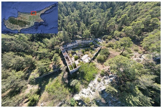
Figure 1.
Aerial view of Sourp Magar Monastery in the forested slopes of the Halevka forest.
Despite its well-established reputation within the Armenian community, the historiography of the monastery had never been systematically studied in previous scholarship. Although its Coptic foundation is attested by historical texts [19,20], only a few scattered notes can be found in historical accounts concerning its foundation and transition into a recognizably “Armenian” monastery, and there have long been calls for more comprehensive analyses of the site [19,21]. Furthermore, due to its location in the Kyrenia Mountains, conducting archaeological work at the site has been politically challenging, due to the division in the island and the intercommunal tensions which began in the 1960s and ended up in the 1974 conflict and its unfortunate aftermath [22]. Except for the regular visits organized by the Armenian community since 2003, neither structured archaeological research nor active Armenian communal use was feasible. Over time, the monastery also became entangled in intra-Cypriot politicized narratives, further complicating its status as a heritage site.
These circumstances, coupled with the gradual physical decay of the monastery within its forest environment, led to the weakening of structural elements and its classification as an endangered monument. Additionally, the mountainous area surrounding the monastery has faced repeated wildfire threats throughout recent history, and such risks are exacerbated by climate change. In response, in 2019, the Cultural Heritage Technical Committee, with the support of the local authorities, Armenian communities, the UNDP, and EU funding, launched a restoration campaign for the monastery. This study emerged as an outcome of that campaign. However, from the very first stages of the project, complications arose, including COVID-19 from 2020 onwards, and other logistic constraints. The challenging terrain of the monastery for restoration efforts further triggered these difficulties, leading to the suspension of the restoration project and placing additional financial strain on the dendroarchaeological studies discussed in this paper.
At the same time, the increasing threat of climate change and the vulnerable state of the monastery turned the scientific study of wooden remains and digital documentation into an urgent rescue project, since wood is one of the vulnerable components in the case of environmental threats [23,24]. A full-scale documentation effort was evidently a necessity under the umbrella of this scientific research project, due to the lack of architectural plans to create a base for systematic dendroarchaeological survey. Furthermore, while the absence of a previous systematic study increased the need for a systematic survey, the aforementioned challenges that followed the suspension of restoration efforts required the adoption of alternative and low-budget solutions for the documentation and study of the monastic complex.
As a result, the combination of LiDAR and aerial photogrammetry emerged as a necessary approach for documenting SMM, particularly given the low-budget and challenging onsite conditions. Both techniques complement each other, with the phone LiDAR recording information where it is not possible for the drone to collect data, and vice versa. Additionally, both techniques provide good resolution texture maps, which is beneficial for visualization purposes. Given the political and economic constraints already affecting the project, the difficult terrain of the monastery in the forested mountain area further complicated the feasibility of conventional LiDAR surveys. Therefore, an alternative method, integrating iPhone LiDAR with photogrammetry, was proposed; its results as applied in the case of SMM are analyzed in this paper.
1.4. iPhone LiDAR in Cultural Heritage Digitization
The integration of laser scanning technology into mobile devices has significantly contributed to the field of cultural heritage documentation. Preliminary studies have demonstrated that the 3D point clouds generated by multi-sensor mobile devices, combining LiDAR, inertial measurement units, and camera input, can enable the accurate and efficient recording of large-scale heritage sites [25]. As a result, as a laser-based remote sensing technology, LiDAR has emerged as a versatile tool for documenting cultural heritage across a wide range of applications, including architectural surveying [26], site modelling [27], and condition assessment [28]. With the introduction of LiDAR technology by Apple in their iPad Pro devices in March 2020, and later in iPhone 12 Pro/Pro Max models in October 2020, its use accelerated among the general public and in the cultural heritage sector, where the need for digital documentation has been a growing necessity [29,30].
These mobile-based sensors offer several advantages, including their portability, ease of use, and ability to capture 3D data quickly and accurately [5,31]. Subsequent to their release, technological evaluations demonstrated that LiDAR-equipped smartphones are capable of producing accurate high-resolution models of small- to medium-scale environments, with positional accuracy sufficient for documentation tasks in both geoscientific and cultural heritage applications [32]. Their accuracy has been specifically compared with TLS and traditional photogrammetry in numerous studies for various applications within the cultural heritage sector [8,10,33,34]. While this study is not concerned with direct comparisons of TLS and photogrammetry, it is important to note that the accuracy of smartphone-based LiDAR systems has been evaluated across diverse applications in heritage and architectural documentation. LiDAR technology in smartphones and tablets has been found to offer relatively accurate results compared to traditional laser scanners and mobile mapping systems, albeit the latter do, in fact, offer superior accuracy per se [7,29,35,36].
The accuracy of LiDAR can be further improved through post-processing workflows that incorporate iterative filtering and orientation correction techniques, which have been shown to enhance both spatial registration and scale reliability in smartphone-based datasets [30]. It is also worth noting that the level of accuracy can vary greatly, depending on the application and data collection methods used, the computer processing power, and incidental factors unique to sites and data collection times. Empirical comparisons between smartphone-based photogrammetry, LiDAR scanning, and hybrid app approaches have highlighted the importance of considering factors such as viewing angles, sensor range, and environmental conditions, which can significantly affect data quality [5,32].
Regardless of incidental drawbacks and lower relative accuracy compared to traditional techniques, several apps are already being used for creating 3D models of spaces and objects, and testing results suggest that each app exhibits its own distinct strength and weaknesses, as summarized in Table 1.

Table 1.
Key results in the literature on the use of iPhone apps and their strengths and weaknesses.
Accordingly, it is essential that each cultural heritage project carefully selects the most appropriate application, based on the specific requirements of the documentation task, environmental constraints, and the desired level of metric precision. To reflect this, the following section details the chosen app’s functionality and limitations, alongside the rationale behind its selection and its role within the broader post-processing workflow.
2. Methods
The method described in this study integrates aerial photogrammetry and iPhone LiDAR to achieve comprehensive digitization of the monastery (Table 2). Drone footage captured large-scale landscape features and high-altitude architectural details, while the iPhone LiDAR scanner accessed and documented interior and covered spaces otherwise inaccessible to drones. The iPhone LiDAR was used mainly in three areas, including roofed rooms forming the south-eastern corner of the monastic complex; the church area in the northern section, with small, vaulted rooms located around it; and a room near the western entrance of the monastery.
Table 2.
Summary of acquisition technologies and methods used in the documentation of Sourp Magar Monastery.
2.1. Data Collection
Data collection in the field was performed in two phases: aerial photogrammetry through DJI Mavic Pro, and on the ground, using iPhone 13 Pro.
During the drone-based survey, a DJI Mavic Air 2S captured 20 MP images in both nadir and oblique orientations. The drone was equipped with a 1″ CMOS sensor (focal length: 8 mm; 22 mm “35 mm equivalent”; sensor pixel size: 2.4 µm). The mission was planned as a double-grid flight at two altitudes (15 m and 25 m above ground level), with forward and side overlaps ranging from 30% to 60%, resulting in ground sampling distances of 0.4 cm/px and 0.8 cm/px, respectively. A total of 506 images were acquired, comprising 164 nadir (≈32%) and 342 oblique (≈68%) photographs; the majority of the latter images were taken at −45°, to capture vertical surfaces and reduce occlusions. The survey footprint covered an area of approximately 89.6 m × 88.7 m (convex-hull area ≈5583 m2), corresponding closely to the monastery’s overall dimensions.
No physical ground control points were available, due to a lack of surveying equipment, and the model was georeferenced solely using the drone’s on-board GNSS positions, embedded in the image EXIF. This method typically yields meter-level absolute accuracy for consumer-grade GNSS, with vertical errors often greater than horizontal. The recorded camera positions form a compact survey envelope (≈89.6 m × 88.7 m, convex-hull area ≈5583 m2), consistent with the site footprint, suggesting stable geotag quality during data acquisition. While satellite count and DOP values were not logged, the absence of erratic positional scatter indicates that satellite visibility was not significantly impaired by the surrounding environment, although partial masking near structures may have locally affected geotag precision. The terrestrial data collection was performed using the iPhone 13 Pro via the 3D Scanner App (v1.1.6,Laan Lab). This software has already been tested in previous scientific research, and has been validated for professional use [10].
During the scanning process, the back camera of the iPhone 13 Pro was used, together with the LiDAR sensor, to capture the 3D data of the exterior and (more specifically) the interior rooms of the monastery, in areas inaccessible to the drone. While the iPhone was constantly moving around the geometry in a stable phase, the data and point cloud was displayed directly on the screen, which was creating the controlled and rapid scanning environment for the operator. The digital survey with the iPhone was carried out with systematic documentation in separate consecutive parts of the monastery (individually), to be merged in the post-processing stage. Overall, seven scans were created (Figure 2).
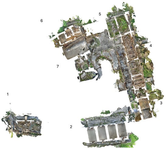
Figure 2.
Locations of the seven individual iPhone LiDAR scans (numbered 1–7) collected sequentially across different parts of the Sourp Magar Monastery. The scans were later grouped into three clusters during post-processing for alignment and 3D reconstruction.
Because there was limited connection to the GPS signal in the interior of the structure, and due to the shortage of battery and data storage in the equipment, the scanning process was completed using chained segment documentation. This is a 3D recording technique in which large or architecturally complex heritage sites are scanned in separate, manageable “segments,” which are later digitally linked to produce a complete model. Rather than relying on a single scanning position to capture the entire monument, the site is systematically divided, and each segment is documented individually, ensuring sufficient overlap between them to allow for precise alignment and reconstruction. This method has proven to be particularly effective for the 3D recording of large and architecturally complex sites [37].
One of the key advantages of this approach is its flexibility; it allows for the detailed capture of complex geometries, obscured features, and otherwise inaccessible areas, while also offering more control during both fieldwork and data processing. However, it also comes with its own set of challenges, most notably the potential for misalignment, especially in irregular or intricately shaped monuments. Therefore, careful planning and precise overlap management are essential to ensure the accuracy and coherence of the final model. This was complemented by the LiDAR acquisition and documentation of architectural details such as door and window frames, stairs, columns, etc., to be used as the basis for alignment with the aerial photogrammetry data.
The main reason for choosing the 3D Scanner App was the opportunity to export the data in various formats (e.g., .ply, .stl, .obj, .xyz, .txt, and .e57) that are commonly used for post-processing 3D data; furthermore, it is one of the few applications that generates point clouds and which has already been tested and recommended for larger data, while remaining free to upload and export data in multiple formats. As reported by prior studies [5,10,32,34], the app has demonstrable accuracy for objects larger than 10 cm, and has been directly compared with TLS and SfM, confirming its suitability for complex heritage documentation among the other apps on the market (Table 1). For this project, the data was exported in .obj files, with a single texture file for each model. Using the app, data extraction is free, and the interface is user-friendly, making it possible for a non-expert in 3D scanning to collect usable data under the remote guidance of a specialist, as was the case at SMM.
2.2. Data Processing
Aerial imagery data was first pre-processed using Adobe Lightroom to homogenize the lighting condition across the data sets. The pre-processing step also improved areas underexposed or overexposed to sunlight. Following this, the aerial imagery was processed using Reality Capture Software (v1.4.2.). The photos were aligned, and the scale was acquired from the drone GPS values, as we did not have permission to use surveying equipment on the site.
The aligned photos were meshed in “Normal details” with 5 mm minimal vertices point distance, and then the mesh was unwrapped using adaptive texel size (between optimal and 10× optimal). The texture was then applied using visibility-based texturing style and 16,384 × 16,384 pixel resolution (Figure 2). The final model consisted of 150 million Polygons with 2 texture maps with a resolution of 16,384 × 16,384 pixels; the model was exported in .obj format and then imported to Cloud Compare software for post-processing and alignment with the LiDAR data.
The iPhone LiDAR scan data was aligned manually, and was combined using Cloud Compare software. First, the visually connected LiDAR scans were manually aligned with each other using cloud-to-cloud alignment by point-pair picking, which resulted in three clusters of LiDAR data to be aligned with the drone data, one at the church and the north wing, one from the east wing and the other one at the south wing (Figure 3). The average point density for the iPhone scans was approximately 1.7 million points per segment, and the texture resolution was 8192 × 8192 pixels per OBJ file.
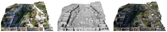
Figure 3.
The processing of the drone-based imagery in Reality Capture; textured (left), meshed model (center), and dense point cloud (right).
The 3D model produced from aerial images was used as the basis for alignment. Each one of the LiDAR clusters were incrementally aligned with the photogrammetry model using pair-point matching. The overlap between the two data sets was between 20 and 30 percent, because the LiDAR was used to capture out-of-reach areas of the monastery.
We used distinct architectural features (e.g., columns, stairs, and window frames) as the key indicator of part of the success of the manual cloud-to-cloud registration. This method was chosen to ensure the accuracy of the alignment, given the relatively small overlap between the two data sets; by focusing on accurately aligning major architectural elements such as roofs and floors, but also details like window frames and stairs, we ensured that there was no minor misalignment. For the alignment, nine pair-points were used per cluster. The pair-points were distributed in the 3D space and between major and minor architectural elements, ensuring that the alignment error of each point did not exceed 5 cm. The overall accuracy was then validated through sectioning the resulting model and ensuring the geometrical continuity (Figure 4).
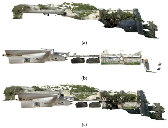
Figure 4.
(a) Section in the drone dataset, (b) section in the LiDAR data set, (c) combined data sets showing the alignment results of the two data sets.
The combined 3D model (Figure 5) was imported into CloudCompare for horizontal and vertical sectioning at different elevation levels. Using the cross-section tool, the model was sliced at fixed height intervals to extract floor plans and elevation profiles, which were then exported as 2D views and further processed in AutoCAD 2024 for refinement and annotation. The sectioning aimed to capture architectural details relevant to both structural interpretation and dendrochronological sampling. While the output was sufficiently precise for the generation of general architectural plans, some distortions occurred in complex areas, especially where vegetation or collapsed material had occluded part of the structure. The complete workflow, integrating UAV photogrammetry and iPhone LiDAR scanning, from acquisition, through processing and integration, to the final outputs, is summarized in Figure 6.
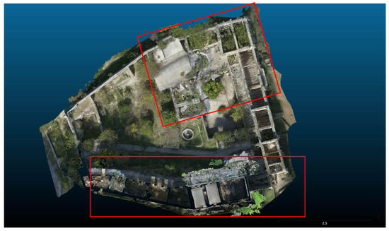
Figure 5.
A floor plan view (of the second floor) of the combined data sets, showing the integration of the smartphone LiDAR with the aerial photogrammetry.
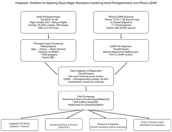
Figure 6.
Integrated workflow for the digital documentation of Sourp Magar Monastery, combining UAV photogrammetry and iPhone LiDAR.
After the visual validation, we used Mesh to Cloud (M2C) distance to further evaluate the quality of the alignment of each cluster. The first cluster to be tested is in the church area (Figure 7). The histogram of the M2C of the first scan (Figure 7c) shows eight classes, two of which are negligibly small. In class 4, we see that the majority of the points (>62%) lie extremely close to zero, indicating a good alignment between the two datasets. Still, there are a number of points in two clusters with a bigger distance between them (−0.5 m to –0.25 m), which suggest a deviation between the LiDAR and photogrammetry meshes. This deviation can be attributed to the heavy vegetation that hindered the capture of geometrical details from the drone flights and the narrow passageways, which made it complicated to completely captured everything using the iPhone LiDAR. On both sides of the histogram there are classes with larger discrepancies, ~1.0 m, which are present in the areas where no drone data was collected and, therefore, there was no overlap.
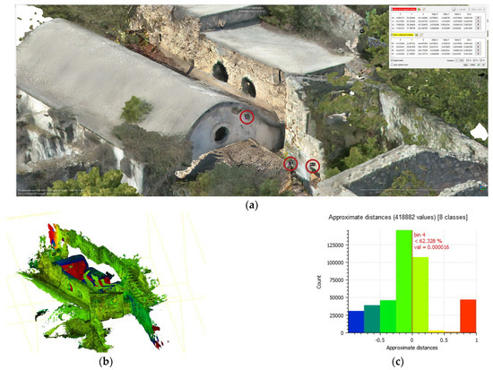
Figure 7.
(a) The pair-points (circled in red) used in the alignment between the photogrammetry and LiDAR data in the second scan of the church area. (b) Overlaid models: the photogrammetry mesh (RGB-textured) and the LiDAR point cloud colored by the M2C scalar field (per point signed distance, m). (c) The histogram result of the M2C algorithm. Horizontal axis: distance (m); vertical axis: point count (n).
The second test area with M2C is from the west wing (Figure 8). The histogram (Figure 8c) shows 3 main classes with 5 smaller classes that are negligibly small (fewer than 5000 points). The majority of points (<64%) are very close to zero, indicating an acceptable alignment between the datasets. Another major class (~10,000 points) shows a distance between 0 m and 0.25 m, which can also be attributed to the high density of vegetation. We also notice that in the data sets we do not see the clusters with the bigger discrepancies, as in the first dataset, because the rooms in this area do not have roofs, so the overlap is well established.
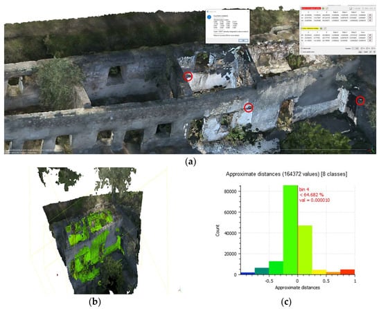
Figure 8.
(a) The pair-points (circled in red) used in the alignment between the photogrammetry and LiDAR data in the scan in the west-wing area. (b) Overlaid models: the photogrammetry mesh (RGB-textured) and the LiDAR point cloud colored by the M2C scalar field( per point signed distance, m). (c) The histogram result of the M2C algorithm. Horizontal axis: distance (m); vertical axis: point count (n).
The last test area is from the north wing (Figure 9). The histogram of the M2C algorithm (Figure 9c) shows eight classes, two of them are negligibly small. The biggest cluster has more than 54% of the points close to zero, indicating a good alignment. Another three clusters have distances between 0.5 m and0.25 m, which can also be attributed to the vegetation. Finally, here we see again the two outliers’ clusters with around 1 m distance variation, which indicates the lack of overlap between the two datasets due to the presence of roofs or vegetation.
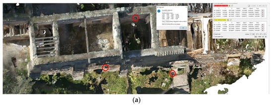
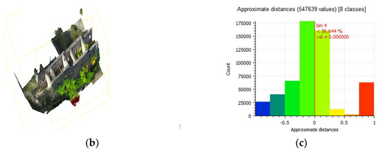
Figure 9.
(a) The pair-points (circled in red) used in the alignment between the photogrammetry and LiDAR data in the scan in the north-wing area. (b) Overlaid models: the photogrammetry mesh (RGB-textured) and the LiDAR point cloud colored by the M2C scalar field (per point signed distance, m). (c) The histogram result of the M2C algorithm. Horizontal axis: distance (m); vertical axis: point count (n).
To further assess the quality of the LiDAR, we also conducted a comparison between one of the LiDAR scans near the church and a photogrammetry model created using the iPhone camera, and 2600 images were collected in the upper church area. The data was processed using Reality Scan Software (v2.0.1.). The resulting model was 230 m million points with two texture maps with the resolution of 16,384*16,384 pixels. The model was subsampled to a lower poly count of 40 m and then imported into Cloud Compare software and aligned with the LiDAR data using the cloud-to-cloud alignment algorithm (Figure 10). Following this, the two models were compared using a Mesh-to-Cloud algorithm. The mean distance was calculated at 1.8 cm, while the standard deviation was calculated at 8 m. These results suggest an acceptable error margin for a rapid and low-cost documentation approach.
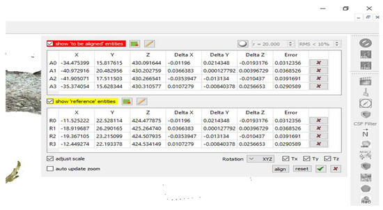
Figure 10.
The error values of the pair-points used in the cloud-to-cloud alignment process.
Although the SfM test produced a visually dense model (230 M points before decimation), several practical factors favored the smartphone LiDAR. First, LiDAR scanning provided real-time visual control on the app screen (Figure 11), allowing operators to detect and fill gaps immediately, while SfM feedback was only available after processing. Second, the low-light, low-texture conditions of the interiors posed challenges for SfM, requiring 2600 photos, intensive processing, and subsequent decimation to 40 M points for integration. Third, LiDAR offered a faster, more practical, and more easily integrable dataset (7 scans of ~1.7 M points each) with sufficient accuracy. These factors made smartphone LiDAR the more suitable choice for rapid documentation of Sourp Magar under constrained conditions.
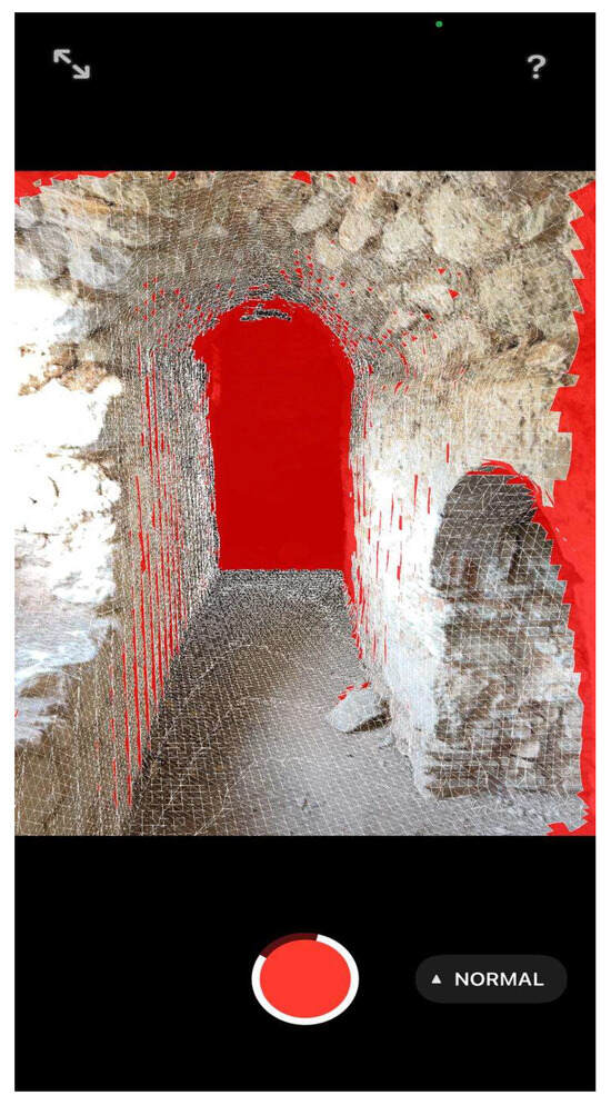
Figure 11.
Example of the iPhone LiDAR scanning interface showing real-time feedback during acquisition inside the upper church corridor of Sourp Magar Monastery. Red areas indicate missing or incomplete geometry, enabling the operator to correct gaps immediately.
3. Results
The total time spent for the acquisition of aerial photogrammetric data of the structure was approximately 1 h, comprising 30 min of flying time and another 30 min for preparation for aerial photogrammetry, and 14 h in the field over seven days (an average of 2 h per day) with the LiDAR. The main reasons for splitting the data collection with the iPhone was the high battery consumption of the application during the acquisition, which restricted the surveying process to two-hour sessions. Also, the first attempts led to several failures encountered during the data acquisition, due to a lack of experience in using such applications. However, thanks to the user-friendly interface of the application and its real-time screen display, most of errors were fixable, and consecutive scans were improved. Also, the data was constantly uploaded to the CYI repository at the end of each survey day, in order to reduce the pressure on the memory capacity of the iPhone. Additionally, during the digital documentation, dendrochronological sampling was also performed in the monastery.
The imaging data processing phase took approximately one day, and was performed in a high-performance workstation (CPU: Intel i9 12th Gen, 64 GB RAM, 1 TB NVMe SSD, 4 TB HDD, 12 GB VRAM graphics card) running Windows 11 Pro. The resulting 3D model of SMM, produced through a combination of aerial photogrammetry and smartphone-based LiDAR data, offers a complete representation of both the exterior and interior architectural features. The integration of drone imagery with LiDAR scanning enabled the generation of high-resolution 3D models, which in turn allowed for detailed spatial analysis, including the extraction of cross-sections for architectural planning. These cross-sections were successfully imported into AutoCAD 2024 software and were used to produce precise architectural drawings of the site.
Beyond academic and technical applications, the resulting 3D model became the foundation for a broader dissemination strategy aimed at enhancing visibility and engagement with SMM. It was featured in the major cultural heritage exhibition Cyprus Insula, organized by the Bank of Cyprus Cultural Foundation, marking the first time the site was formally presented in a national institutional context outside the Armenian community (For details on the Cyprus Insula Exhibition, see https://www.boccf.org/en-gb/homepage/exhibitions-actions/exhibitionsevents/kypros-nisos/ (accessed on 7 September 2025) This outcome would not have been possible without the digital model produced through the low-cost documentation workflow described in this paper, which provided a flexible and shareable medium for outreach. The model was also circulated via social media. It is also planned to disseminate the created model and data for open-access release through platforms such as the ECHOES heritage cloud repository.
The dissemination strategy targets several key audiences, including the Armenian community in Cyprus, nature enthusiasts who regularly visit the surrounding forest trails, and scholars and heritage professionals engaged in medieval and monastic studies. By enabling both public and academic engagement, the model helps reposition the monastery within broader cultural and scholarly narratives, ensuring its continued visibility and care. Conference presentations and scholarly contributions further support this strategy, extending the impact of the model into international academic discourse. The created digital model was segmented in the CloudCompare environment to propose and extract insights into the early phases of the monastery, informed by observations, and results from the architectural and dendroarchaeological surveys of the monastic complex. Similarly, several suggested phases, like the east façade or the south wing of SMM have been digitally extracted and presented, in relevant efforts to study the monastery’s historical development.
4. Discussion
In addition to the discussion of the project’s workflow and the acquired results, it is important to consider how the specific challenges posed by the site itself shaped the methodology and outcomes of this study. As previously noted, the monastery’s location in a remote and forested part of the Kyrenia Mountains, combined with its limited accessibility, necessitated the development of a workflow that could accommodate a rapid mode of documentation with acquired results being able to sustain a remote working environment. In response to this need, the integrated workflow presented in this study, combining iPhone LiDAR scanning with aerial photogrammetry, was specifically designed to address these constraints, and offer a flexible yet effective solution for working on modelling such environments. The difficult terrain surrounding the monastery presented logistical constraints for data acquisition, while limited funding and the need to secure permission added to the complexity of fieldwork efforts. This permission was acquired through the support of the UNDP Technical Committee on Cultural Heritage in Cyprus.
These constraints help to emphasize the real-world difficulties often encountered in cultural heritage documentation, especially in remote or conflict-affected areas. The uncontrolled nature of the environment surrounding SMM, contrasted with the controlled settings of object-based or more controlled experiments [10], posed additional challenges, including lighting variations and the need to work around ongoing activities at the site. Moreover, the chosen combined approach, integrating iPhone LiDAR with airborne photogrammetry, introduced its own limitations related to data integration and processing. Specifically, the limited battery life of the iPhone LiDAR, in an environment with no mains electrical connection, proved to be a significant constraint, requiring careful planning and management of survey time and data uploads.
Furthermore, while the workflow proved efficient under the circumstances at SMM, it is also worth mentioning the epistemological consequences of relying on mobile LiDAR. During the analyses on the 3D model, it was detected that certain finer architectural details, such as tool marks or inscriptions, were undetected, which in turn limits the potential for detailed material or stylistic analysis. This raises important questions about the balance between accessibility and resolution in digital heritage work, particularly when these models are used for future comparative or conservation purposes.
Despite these challenges, the combined methodological approach proved quite efficient in the creation of a digital model of the SMM complex. While not a replacement for TLS in applications requiring high precision, iPhone LiDAR demonstrated a lot of potential as a viable tool for preliminary assessments, public outreach, and heritage preservation, particularly where advanced equipment is inaccessible and/or resources are limited. This effort is in line with research highlighting the potential of mobile LiDAR in documenting relief sculptures [10], where its accessibility makes it a cost-effective tool. The rapid data acquisition capabilities of phone-based LiDAR, particularly beneficial in challenging environments, enables broader engagement with heritage sites, increasing the awareness of their preservation among local communities and broader audiences. In the specific case of the SMM, presenting the model in a public exhibition further underscores this point. It provided a tangible outcome that bridged the gap between academic documentation and public history (and cultural expression), fostering visibility of, and engagement with, a site that had long remained overlooked. This outcome is worth mentioning as a signifying element, to demonstrate the role of digital workflows not only in analysis and preservation, but in repositioning cultural heritage sites within collective memory and public discourse.
Turning to the scientific impact of this workflow to the project in more depth, it is important to note that the created 3D model has already been used to produce architectural plans for the monastery’s past and present, which is a notable achievement of the digital survey described in this paper. The two-story complex layout and irregular rectangular shape of the SMM, as well as its long history of substantial restorations across different historical periods, can now be visualized. Considering the centuries-long use of the monastery, the various building phases of the complex are often intertwined with each other. It is therefore important that before any systematic architectural or dendroarchaeological survey, surveyors first acquire a clear and coherent base architectural plan, which can ideally be achieved through the creation of an accurate 3D model of remaining structures, providing an essential foundation both for rapid mapping and for generating initial documentation of the site.
In this regard, the architectural plan of the monastery, which was based on the created 3D model, became the basis for a comprehensive survey. It was used not only for architectural purposes but, more critically, for coding and recording the collected tree-ring samples. Each room was assigned a unique code, which was then mapped onto the plan and linked directly to the relevant samples. This approach ensured that the contextual information of each sample was clearly defined, while also facilitating the spatial interpretation of the dendrochronological results. Naturally, the plan did not only serve the dendroarchaeological survey, but also enabled a more systematic architectural survey in general, offering a shared framework through which different contexts could be identified and analyzed.
The 3D model was not produced simply to provide a visual representation; rather, it became a functional research tool. It allowed hypotheses to be developed through 2D plans (Figure 12), and field observations to be tested and refined at a new level of precision. Some of the monastery’s earliest construction phases had become nearly invisible beneath later layers, and in several cases, these structures could not be captured even by drone documentation, due to the fact that they were embedded in later period rooms and other architectural additions. Through the use of handheld LiDAR scanning, researchers were able to record these early rooms in detail. Once integrated into the digital model, these spaces were examined in relation to one another, helping the main research project to understand the spatial distribution of the earliest architectural phase and identify key differences in construction techniques. Room orientations and internal spatial relationships were likewise clarified through created 2D and 3D models, in addition to the field survey.
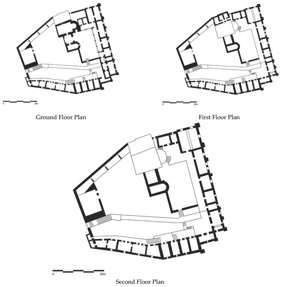
Figure 12.
Different floor plan views produced from the 3D survey.
Beyond its immediate use for public exhibition, dendroarchaeological sampling, and architectural survey, the digital model of the monastery holds great potential for future research on the restoration and interpretation of the monument. As a research tool, the model offers a detailed spatial framework that can support future studies, from architectural history and material analysis to comparisons with other medieval monastic sites in Cyprus and beyond.
At the same time, much of the material culture that was once located at the monastery is now scattered across different countries; thus, this digital model linked with a digital repository may become the only space where these objects can be virtually brought back together and studied in a meaningful way by researchers from different disciplines and backgrounds. This will undoubtedly strengthen research on the monastery and push the limits of what is possible through a 3D model.
In conclusion, the presented workflow contributes to a growing body of digital heritage practices that seek to operate effectively in politically sensitive, remote, or under-resourced contexts. By adapting consumer-grade technologies such as smartphone LiDAR for academic and heritage documentation purposes, this study proposes a pragmatic yet critically aware model that balances technological limitations with field-based exigencies. For conservation, the model provides an accurate snapshot of the current condition of the monastery, helping to monitor its state over time, and inform future preservation work. Overall, the described method offers an effective tool that can be rapidly used to document and create 3D models of architectural heritage sites, even in challenging locations, and by nonspecialist operators. It offers a template for similar workflows in other heritage sites where traditional methods may not be feasible, while remaining attentive to the interpretive consequences of the tools employed in the real-world case.
Author Contributions
Conceptualization, M.S.; Methodology, M.S. and R.O.; Software, R.O.; Data curation, R.O.; Writing–original draft, M.S.; Writing–review & editing, R.O., S.H. and N.B.; Visualization, R.O.; Supervision, S.H. and N.B. All authors have read and agreed to the published version of the manuscript.
Funding
This research received no external funding.
Data Availability Statement
The original contributions presented in this study are included in the article. Further inquiries can be directed to the corresponding author(s).
Acknowledgments
The authors express their gratitude to the Technical Committee on Cultural Heritage (TCCH) for its support in the study of the Sourp Magar Monastery. Many thanks also got to the entirety of the APAC Labs/ STARC team for all its help in various aspects of of this projecτ. We also thank the Academic Editor and the anonymous reviewers for their constructive comments and suggestions, which substantially improved this manuscript.
Conflicts of Interest
The authors declare no conflict of interest.
Abbreviations
The following abbreviations are used in this manuscript:
| LiDAR | Light Detection and Ranging |
| SfM | Structure-from-motion |
| SMM | Sourp Magar Monastery |
| TLS | Terrestrial laser scanning |
| UAV | Unmanned aerial vehicle |
References
- Wei, O.C.; Chin, C.S.; Majid, Z.; Setan, H. 3D Documentation and Preservation of Historical Monument Using Terrestrial Laser Scanning. Geoinf. Sci. J. 2010, 10, 73–90. [Google Scholar]
- Liu, J.; Azhar, S.; Willkens, D.; Li, B. Static Terrestrial Laser Scanning (TLS) for Heritage Building Information Modeling (HBIM): A Systematic Review. Virtual Worlds 2023, 2, 90–114. [Google Scholar] [CrossRef]
- Pepe, M.; Alfio, V.S.; Costantino, D. UAV Platforms and the SfM-MVS Approach in the 3D Surveys and Modelling: A Review in the Cultural Heritage Field. Appl. Sci. 2022, 12, 12886. [Google Scholar] [CrossRef]
- Barba, S.; Ferreyra, C.; Cotella, V.A.; Di Filippo, A.; Amalfitano, S. A SLAM Integrated Approach for Digital Heritage Documentation. In Culture and Computing. Interactive Cultural Heritage and Arts; Rauterberg, M., Ed.; Lecture Notes in Computer Science; Springer International Publishing: Cham, Switzerland, 2021; Volume 12794, pp. 27–39. ISBN 978-3-030-77410-3. [Google Scholar]
- Askar, C.; Sternberg, H. Use of Smartphone Lidar Technology for Low-Cost 3D Building Documentation with iPhone 13 Pro: A Comparative Analysis of Mobile Scanning Applications. Geomatics 2023, 3, 563–579. [Google Scholar] [CrossRef]
- Ulvi, A.; Hamal, S.N.G. Fusion of IPAD Pro LiDAR and SfM-Based Photogrammetry for 3D Documentation of Cultural Heritage. Iran. J. Sci. Technol. Trans. Civ. Eng. 2025. [Google Scholar] [CrossRef]
- Zhang, N.; Lan, X. Everyday-Carry Equipment Mapping: A Portable and Low-Cost Method for 3D Digital Documentation of Architectural Heritage by Integrated iPhone and Microdrone. Buildings 2024, 15, 89. [Google Scholar] [CrossRef]
- Noguchi, A.; Nakamura, R.; Takata, Y.; Matsuo, Y.; Oya, Y.; Uchida, S. Comparison and Evaluation of TLSS and Mobile Lidar Scanners for Multi-Scale 3D Documentation of Cultural Heritage. Int. Arch. Photogramm. Remote Sens. Spat. Inf. Sci. 2023, XLVIII-M-2–2023, 1135–1139. [Google Scholar] [CrossRef]
- Teppati Losè, L.; Spreafico, A.; Chiabrando, F.; Giulio Tonolo, F. Apple LiDAR Sensor for 3D Surveying: Tests and Results in the Cultural Heritage Domain. Remote Sens. 2022, 14, 4157. [Google Scholar] [CrossRef]
- Vacca, G. 3D Survey with Apple LiDAR Sensor—Test and Assessment for Architectural and Cultural Heritage. Heritage 2023, 6, 1476–1501. [Google Scholar] [CrossRef]
- Atencio, E.; Muñoz, A.; Lozano, F.; González-Arteaga, J.; Lozano-Galant, J.A. Calibration of iPad Pro LiDAR Scanning Parameters for the Scanning of Heritage Structures Using Orthogonal Arrays. Appl. Sci. 2024, 14, 11814. [Google Scholar] [CrossRef]
- Barthel-Bouchier, D. Cultural Heritage and the Challenge of Sustainability; Routledge: London, UK, 2016; ISBN 978-1-315-43104-8. [Google Scholar]
- Macdonald, S. Difficult Heritage; Routledge: London, UK, 2010; ISBN 978-1-134-11106-0. [Google Scholar]
- Tunbridge, J.E.; Ashworth, G.J. Dissonant Heritage: The Management of the Past as a Resource in Conflict; John Wiley and sons: Chichester, UK, 1995; ISBN 978-0-471-94887-2. [Google Scholar]
- Meskell, L. Negative Heritage and Past Mastering in Archaeology. Anthropol. Q. 2002, 75, 557–574. [Google Scholar] [CrossRef]
- ICOMOS Climate Change and Cultural Heritage Working Group (Corporate Author). The Future of Our Pasts: Engaging Cultural Heritage in Climate Action; ICOMOS: Paris, France, 2019. [Google Scholar]
- Fatorić, S.; Seekamp, E. Are Cultural Heritage and Resources Threatened by Climate Change? A Systematic Literature Review. Clim. Change 2017, 142, 227–254. [Google Scholar] [CrossRef]
- UNESCO World Heritage Centre (Corporate Author). Updated Policy Document on Climate Action for World Heritage; UNESCO: Paris, France, 2023. [Google Scholar]
- Coureas, N. The Coptic Presence in Cyprus During the Fifteenth and Sixteenth Centuries. In Egypt and Syria During the Fatimid, Ayyubid and Mamluk Eras; Vermeulen, U., D’Hulster, K., Eds.; OLA; Peeters Publishers: Leuven, Belgium, 2007; Volume 5, pp. 439–450. [Google Scholar]
- Boud’hors, A. Manuscrits Coptes “Chypriotes” à La Bibliothèque Nationale. In Études Coptes: Troisième Journée d’études, Musée du Louvre 23 Mai 1986; Bosson, M.-L., Ed.; Cahiers de la Bibliothèque Copte; Peeters: Leuven, Belgium, 1989; Volume 4, pp. 11–20. [Google Scholar]
- Imhaus, B. Le Monastère de Saint-Macaire En Chypre. In L’Église Arménienne Entre Grecs et Latins (fin XIe-Milieu XVe Siècle); Augé, I., Dédéyan, G., Eds.; Association Pour L’étude de la Civilisation Byzantine: Paris, France, 2009; pp. 193–204. [Google Scholar]
- Hardy, S.A. Interrogating Archaeological Ethics in Conflict Zones: Cultural Heritage Work in Cyprus. Ph.D. Thesis, University of Sussex, Brighton, UK, 2011. [Google Scholar]
- Pedersen, N.B.; Matthiesen, H.; Blanchette, R.A.; Alfredsen, G.; Held, B.W.; Westergaard-Nielsen, A.; Hollesen, J. Fungal Attack on Archaeological Wooden Artefacts in the Arctic—Implications in a Changing Climate. Sci. Rep. 2020, 10, 14577. [Google Scholar] [CrossRef]
- Sabbioni, C.; Cassar, M.; Brimblecombe, P.; Lefèvre, R.-A. Vulnerability of Cultural Heritage to Climate Change. In European and Mediterranean Major Hazards Agreement (EUR-OPA); Council of Europe: Strasbourg, France, 2008; pp. 1–24. [Google Scholar]
- Rodríguez-Gonzálvez, P.; Jiménez Fernández-Palacios, B.; Muñoz-Nieto, Á.; Arias-Sanchez, P.; Gonzalez-Aguilera, D. Mobile LiDAR System: New Possibilities for the Documentation and Dissemination of Large Cultural Heritage Sites. Remote Sens. 2017, 9, 189. [Google Scholar] [CrossRef]
- Orabi, R. Masons’ Marks in Aleppo, a Study of a Defensive Tower in Old Aleppo: Using 3D Laser Scanning and Photogrammetry for Identification and Classification. Digit. Appl. Archaeol. Cult. Herit. 2020, 19, e00154. [Google Scholar] [CrossRef]
- Andreou, G.M.; Opitz, R.; Manning, S.W.; Fisher, K.D.; Sewell, D.A.; Georgiou, A.; Urban, T. Integrated Methods for Understanding and Monitoring the Loss of Coastal Archaeological Sites: The Case of Tochni-Lakkia, South-Central Cyprus. J. Archaeol. Sci. Rep. 2017, 12, 197–208. [Google Scholar] [CrossRef]
- Li, Y.; Zhao, L.; Chen, Y.; Zhang, N.; Fan, H.; Zhang, Z. 3D LiDAR and Multi-Technology Collaboration for Preservation of Built Heritage in China: A Review. Int. J. Appl. Earth Obs. Geoinf. 2023, 116, 103156. [Google Scholar] [CrossRef]
- Aljadire, A.A.; Khalaf, Y.H. A Study in Preserving Cultural Heritage Using Portable Laser Devices Embedded in Mobile Phones. IOP Conf. Ser. Earth Environ. Sci. 2024, 1374, 012041. [Google Scholar] [CrossRef]
- Tavani, S.; Pignalosa, A.; Corradetti, A.; Mercuri, M.; Smeraglia, L.; Riccardi, U.; Seers, T.; Pavlis, T.; Billi, A. Photogrammetric 3D Model via Smartphone GNSS Sensor: Workflow, Error Estimate, and Best Practices. Remote Sens. 2020, 12, 3616. [Google Scholar] [CrossRef]
- Gautier, Q.K.; Garrison, T.G.; Rushton, F.; Bouck, N.; Lo, E.; Tueller, P.; Schurgers, C.; Kastner, R. Low-Cost 3D Scanning Systems for Cultural Heritage Documentation. J. Cult. Herit. Manag. Sustain. Dev. 2020, 10, 437–455. [Google Scholar] [CrossRef]
- Luetzenburg, G.; Kroon, A.; Bjørk, A.A. Evaluation of the Apple iPhone 12 Pro LiDAR for an Application in Geosciences. Sci. Rep. 2021, 11, 22221. [Google Scholar] [CrossRef]
- Murtiyoso, A.; Grussenmeyer, P.; Landes, T.; Macher, H. First Assessments into the Use of Commercial-Grade Solid State Lidar for Low Cost Heritage Documentation. Int. Arch. Photogramm. Remote Sens. Spat. Inf. Sci. 2021, XLIII-B2-2021, 599–604. [Google Scholar] [CrossRef]
- Díaz-Vilariño, L.; Tran, H.; Frías, E.; Balado, J.; Khoshelham, K. 3D Mapping of Indoor and Outdoor Environments Using Apple Smart Devices. Int. Arch. Photogramm. Remote Sens. Spat. Inf. Sci. 2022, XLIII-B4-2022, 303–308. [Google Scholar] [CrossRef]
- Maté-González, M.Á.; Di Pietra, V.; Piras, M. Evaluation of Different LiDAR Technologies for the Documentation of Forgotten Cultural Heritage under Forest Environments. Sensors 2022, 22, 6314. [Google Scholar] [CrossRef] [PubMed]
- Ruskovski, I.; Gavrilović, M.; Govedarica, M. Performance and Accuracy Analysis of Leica P20 Scanner and iPhone LiDAR Sensor in Scanning of Cultural Heritage Objects. In Proceedings of the International Scientific Conference iNDiS 2023 “Planning, Design, Construction and Building Renewal”, Novi Sad, Serbia, 24–26 October 2023. [Google Scholar]
- Deng, F.; Zhu, X.; Li, X.; Li, M. 3D Digitisation of Large-Scale Unstructured Great Wall Heritage Sites by a Small Unmanned Helicopter. Remote Sens. 2017, 9, 423. [Google Scholar] [CrossRef]
Disclaimer/Publisher’s Note: The statements, opinions and data contained in all publications are solely those of the individual author(s) and contributor(s) and not of MDPI and/or the editor(s). MDPI and/or the editor(s) disclaim responsibility for any injury to people or property resulting from any ideas, methods, instructions or products referred to in the content. |
© 2025 by the authors. Licensee MDPI, Basel, Switzerland. This article is an open access article distributed under the terms and conditions of the Creative Commons Attribution (CC BY) license (https://creativecommons.org/licenses/by/4.0/).