1. Introduction
In recent decades, growing demand for supposedly sustainable tourism experiences has led to changes in tourism development models. These models have increasingly shifted towards more environmentally friendly approaches, focused on the continuous enhancement of natural and cultural heritage. In this context, protected natural areas (PNAs) have consolidated their prominent role as ideal settings for tourism that combines environmental conservation with the generation of knowledge, environmental awareness and territorial appreciation. This trend reflects both growing awareness of global challenges—such as climate change and biodiversity loss—and a paradigm shift in visitor behaviour, with increasing demand for proposals offering stronger interpretative, educational, and experiential content.
Educational tourism, understood as a form of tourism that promotes learning in cultural or natural environments, is emerging as a strategic tool for strengthening sustainability in these areas. Its implementation in PNAs is closely associated with responsible tourism, as it enables the articulation of a link between conservation and local development, offering visitors learning opportunities while providing local communities with a means of economic diversification that does not compromise territorial values.
In Spain, these issues have not gone unnoticed. Tourism plays a fundamental role in the country’s economy and cultural identity, being one of the main drivers of development in many of its regions. Beyond traditional sun and beach tourism, which accounts for a significant part of demand, there has been growing interest for some time in a more responsible and sustainable model of tourism, in harmony with the environment and local communities, where educational tourism fits in well. This type of tourism is particularly important in inland regions with outstanding natural and cultural heritage, which can be leveraged to revitalise areas that often suffer from pronounced socio-economic imbalances.
Castilla-La Mancha is a Spanish region that stands out in this context. The region, and particularly Ciudad Real, one of its provinces, has a diverse and significant network of PNAs that represents a remarkable opportunity to advance in these lines of work. However, the starting point is the hypothesis that the availability and quality of public facilities in these spaces in the province of Ciudad Real show marked inequality. This fact may compromise the viability and real impact of educational tourism, as there is a direct correlation between the density of quality interpretive infrastructure and the suitability of the space to establish itself as a competitive destination. In this context, the general objectives of this study are: (1) to establish a preliminary diagnosis of the availability and quality of public facilities with educational potential in the protected natural areas (PNAs) of the province of Ciudad Real, with particular attention to their capacity to integrate the landscape dimension as a pedagogical and interpretive resource; and (2) to determine which areas are most suitable for the development of educational tourism initiatives. The specific objectives of the study are: (a) to identify and characterise the interpretive and informational resources available in the selected PNAs, explicitly evaluating the extent to which these resources incorporate the landscape as a key element for learning through tourism-related activities; and (b) to identify the areas with the greatest potential for the development of educational tourism proposals, considering factors such as accessibility, the presence of facilities, and the availability of informational materials.
This specific focus on landscape reflects its often underestimated role in educational tourism processes within PNAs, despite being a structuring component of the territory and a resource with high interpretive potential.
Through a methodology based on fieldwork and comparative analysis, the aim is to provide up-to-date diagnoses useful for the planning and sustainable management of PNAs, considered as essential settings for environmental education and awareness-raising around the landscape.
3. Materials and Methods
3.1. Study Area: Province of Ciudad Real (Castilla-La Mancha, Spain)
Castilla-La Mancha is a Spanish autonomous community (79,462 km
2) located in the central inland area of the Iberian Peninsula. With a high average altitude (more than 80% of its surface area is above 650 m), the region’s terrain is dominated by wide plains and valleys, framed by a border of mountain ranges with diverse complex morphological structures (the Central System, the Iberian System, the Baetic Systems, the Sierra Morena and the Montes de Toledo and Ciudad Real). The dominant climate is temperate Mediterranean, with an average annual temperature of 17 °C and average rainfall of around 450 mm. Its capital is the city of Toledo (86,526 inhabitants in 2025) and its administrative structure is composed of 5 provinces (Albacete, Ciudad Real, Cuenca, Guadalajara and Toledo) and 919 municipalities (
Figure 1). In 2025, the region had a population of 2,140,796 inhabitants (
I.N.E., 2025), mainly engaged in the service sector, although with a significant weight in the agricultural sector (cereals, vines and olive trees). Since 2010, the region has been undergoing a significant process of rural depopulation, with urban growth in the areas closest to Madrid.
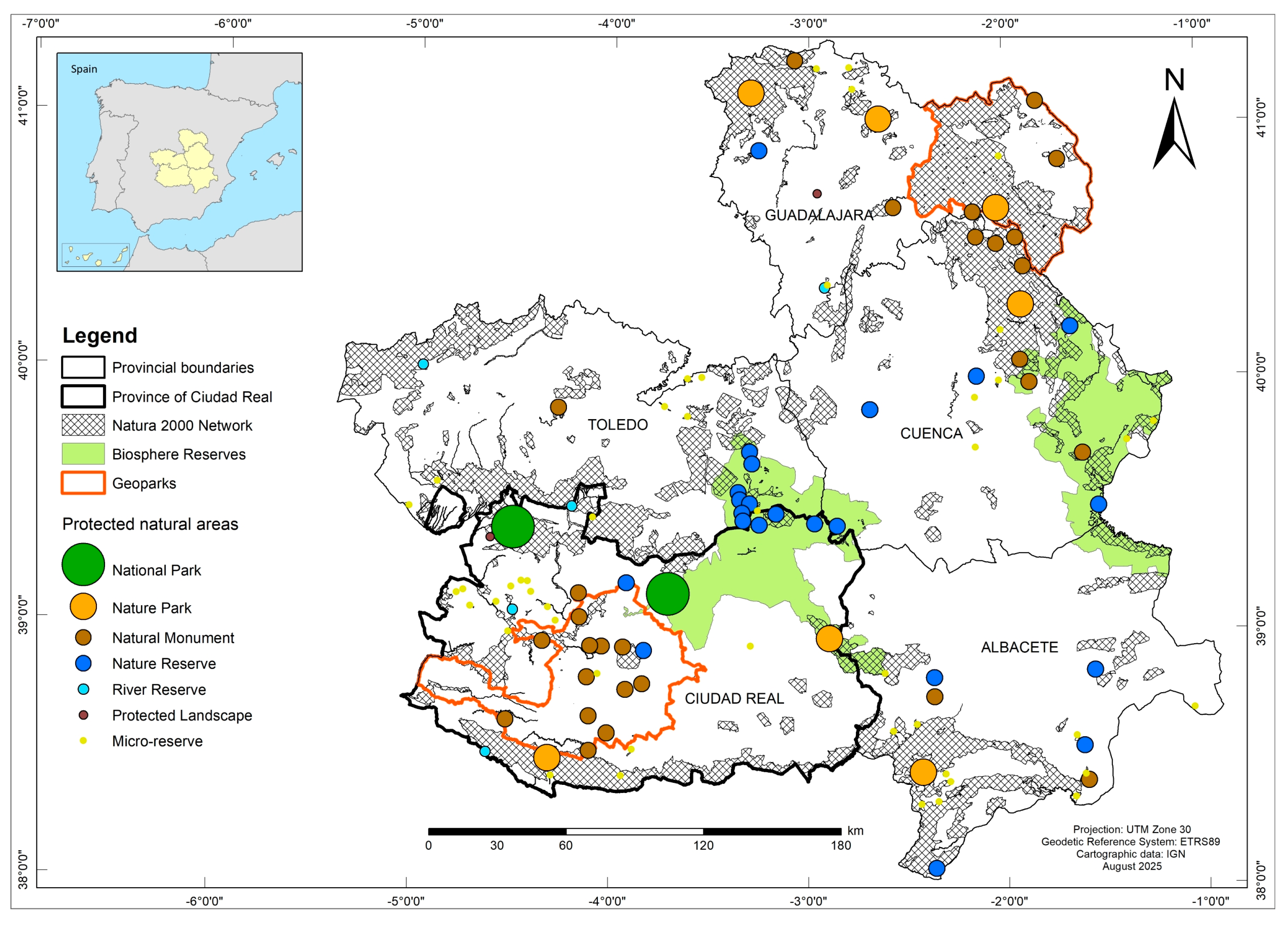
According to nature conservation, Castilla-La Mancha has a Network of Protected Areas that includes 114 registered PNAs and is one of the Spanish regions with the largest protected area (almost 600,000 ha), including National Parks, Natural Parks, Nature Reserves and Natural Monuments, among others (
Figure 1). The region is also part of the Natura 2000 Network, with 40 Special Protection Areas for Birds (SPAs) and 72 Special Areas of Conservation (SACs) (
Government of Castilla-La Mancha, 2025).
In accordance with the hypotheses and conceptual bases outlined above, this research has focused on the network of protected areas in the province of Ciudad Real, a province in Castilla-La Mancha that is particularly rich and diverse in this type of space (
Jerez et al., 2017). Of the 50 Spanish provinces, Ciudad Real is the third largest and is home to almost half of the 114 autonomous PNAs currently in existence (2 National Parks, 2 Natural Parks, 7 Nature Reserves, 13 Natural Monuments, 3 River Reserves, 18 Micro-reserves and 1 Protected Landscape), and is the only one that has all the protection categories included in current regional legislation.
3.2. Fieldwork Instrument: Diagnostic Form for Educational Tourism Resources
The methodological procedure for achieving the proposed objectives was based on field research with a diagnostic and evaluative approach of an inductive nature, complemented in the office with various sources and theoretical approaches. This approach has made it possible to combine qualitative and quantitative techniques to analyse educational tourism resources that are useful for guiding the planning or management of PNAs. Of the many variables that exist for the study and assessment of this type of tourism, this work has focused on the presence or absence of different interpretive interventions, considered to be one of the main resources that favour this type of tourist-recreational activity. Socio-economic, institutional and behavioural factors, including tourist demand, were deliberately excluded from the study, which thus prioritises the spatial, provision and operational analysis of PNAs. This methodological decision ensures the homogeneity of the inventory, the comparative validity between PNAs and alignment with the overall objective of the work.
Thus, the variables analysed in this study focus on tourism-education infrastructures useful for learning through tourism activities, among which the following have been prioritised: (1) the network of public facilities for visits and environmental education (interpretation centres, museum centres, nature classrooms, observatories, viewpoints, interpretive panels, marked trails, interpretive trails), (2) the existence of institutional informational/educational materials (guides or field notebooks, brochures, visitor maps, websites, and mobile applications), and (3) accessibility to these spaces (general and local road signage, availability of parking).
During data collection, special attention was given to the significance of the landscape as an educational resource across all variables. This approach was framed from the perspective of interpretive planning, referring to the degree to which ecological, aesthetic, and heritage values inform the relevance, design, and placement of interpretive resources and infrastructure. This aspect was addressed using complementary indicators based on (1) the presence of landscape observation points (viewpoints, panoramic landmarks, and unique enclaves), (2) the explicit inclusion of landscape elements in interpretive panels or information resources, and (3) the degree of correspondence between the landscape values identified in the field and their translation into educational or interpretive content. In the tourism context, this consideration was applied according to the relevance and strategic value of the landscape as a tourist resource and as a criterion for designing interpretive facilities and infrastructure, rather than on the subjective meanings attributed by visitors.
The main diagnostic tool used to obtain data on the selected variables was the design and application of a field form. This form enabled the collection of structured data on the educational tourism resources (interpretive and informative) existing in a set of selected PNAs in the province of Ciudad Real. The data were collected through direct observation, recording and on-site analysis in each space. The design and use of the form served as a standardised tool to facilitate subsequent comparison of the different resources inventoried in each PNA and by protection status.
The field data sheet design is structured around three main areas. The first area focuses on two aspects: (1) the collection of general geographical data (location, type, surface area, type of ownership, land use and main natural and cultural values) to provide a general description of each PNA; and (2) the inventory and preliminary analysis of the network of public facilities for each selected PNA, with special attention to infrastructure and interpretive facilities as the main tourist resources.
The second focus has prioritised the inventory of trails or routes for public use in each PNA; this includes the compilation of informational materials, with special attention given to digital and interactive tools (websites, mobile applications, QR codes, and digital guides), and the identification of unique elements for interpretation. Particular attention was given to collecting data on interpretive trails and itineraries, as these represent one of the most sought-after resources for nature-based hiking activities among visitors matching the tourist profile under study. In this regard, the provision of these trails has been decisive in differentiating those that are simply signposted from those that feature a carefully considered spatial configuration of the interpretive route. The former are distinguished by the lack of specific and direct references to the environmental values of the route, which compromises their accessibility and understanding; while the latter feature strategic markers or panels that are useful for contemplating and understanding the main natural components of the space and the need to protect them.
Finally, the third focus addressed different elements to assess accessibility to these spaces from the nearest towns (roads, tracks or paths) and the state of repair of the facilities included in the previous focus. Overall, information was collected on six variables for each selected PNA: (1) general access road signage; (2) local access road signs (paths); (3) presence of car parks; (4) state of repair of access paths; (5) state of repair of main facilities; and (6) state of repair of interpretive panels.
During data collection, special attention was paid to the significance of the landscape, which was understood from the perspective of interpretive planning, referring to the degree to which its ecological, aesthetic and heritage values determine the relevance, design and location of interpretive resources and infrastructure. In terms of tourism, this consideration has been applied based on the relevance and strategic value of the landscape as a tourist resource and as a criterion for the design of interpretive facilities and infrastructure, not on the subjective meaning attributed by visitors.
The diagnostic form was applied through a series of field studies carried out between 2021 and 2024, with recurring visits to 35 of the 46 PNAs (76%) currently registered in the province of Ciudad Real. The remaining areas were not considered for various reasons, including: their location between two provinces and their small surface area in the province under analysis; their integrated treatment together with other larger areas that encompass them; or their difficulty of access due to their location on private property, among others.
The compilation work carried out through fieldwork has been supplemented with information from various statistical and documentary sources, including the repository of the Network of Protected Areas of Castilla-La Mancha (
Government of Castilla-La Mancha, 2025) and the manuals on concepts of public use in PNAs (
EUROPARC-España, 2005,
2006). Finally, the procedure is completed with the preparation of a photographic and cartographic dossier.
3.3. Evaluation Criteria for Educational Tourism Potential
To assess the tourism and educational potential of the selected PNAs, the information collected in the field as detailed above has been organised and supplemented with institutional sources on PNAs and environmental education (
JCCM, 2020,
2025). All this data has been used to create an evaluation matrix to determine the potential for educational tourism in each area and its relationship with the network to which it belongs, based on the presence, richness and state of conservation of the different components collected for each PNA.
In order to ensure consistency in the inventory and reinforce the replicability of the analysis, the recording and classification of resources was based on explicit operational criteria applied uniformly across all PNAs. Each variable was defined according to previously established definitions (
EUROPARC-España, 2005,
2006), distinguishing between presence or absence, conservation status and functionality of the resource. Similarly, the assignment of each PNA to a category of tourism-educational potential responded to the systematic combination of the three selected factors: accessibility, interpretive provision and availability of informational materials, so that the assignment of each PNA to a category was systematic and did not depend solely on expert judgement. To minimise assessment bias, the inventory was validated through verification visits, comparison with institutional sources, and an independent internal review by the group’s researchers (
Blanco Cerradelo et al., 2015;
Navrátil et al., 2015).
Priority has been given to the selection of criteria such as (1) degree of accessibility to the PNA; (2) presence and state of conservation of facilities; and (3) availability of informational/educational resources and materials, printed and digital, which have been considered as categorical variables. In considering these factors, a main tourist-educational attraction has also been determined, which we have defined as those places, elements or activities for which the assessed PNA records the highest number of visits, and which are directly associated with the most notable characteristics with which each PNA can contribute to promoting its own process of dissemination, assessment and teaching. The recurrence factor has been applied by evaluating the selected variables in terms of presence or absence for each selected PNA. This has made it possible to determine the frequency with which each variable appears and the combinations between them. The assessment of the state of conservation of the main indicators, for its part, has focused on the analysis of local road infrastructure, main facilities and interpretive panels.
The inventory obtained has enabled subsequent coding on ordinal scales (high/medium/low) to establish basic criteria for the categorical classification of each space’s potential based on qualitative values regarding the existence or absence of the variables considered. Qualitative comparative analyses have been based on two sets of variables: interpretative endowment (facilities) and evaluative strategy (accessibility and state of conservation).
Based on all of the above, a basic evaluation scale has been established in which high tourism-educational potential is attributed to those PNAs that meet the three factors considered (good accessibility, abundance and good state of conservation of interpretive facilities; and existence of resources and informative/educational materials for tourism purposes); medium tourism-educational potential is assigned to PNAs that meet two of the factors considered; and low tourism-educational potential is assigned to those PNAs that do not meet or only meet one of the factors considered.
Finally, a simple threshold analysis was carried out to test the sensitivity of the classification system (
Saltelli et al., 2004;
Blanco Cerradelo et al., 2015). To this end, we evaluated how the category assigned to each PNA would vary if one of the indicators included in the matrix—accessibility, interpretive facilities, or availability of informational materials—were hypothetically moved to the next higher or lower level. This procedure allowed us to identify PNAs close to the boundaries between categories and verify the stability of the proposed classification.
4. Results
The Network of Protected Areas of Castilla-La Mancha receives 1,500,000 visitors annually, of which around 100,000 visited the network’s interpretation centres and information points in 2024, mostly operational only on weekends and holiday periods (
Government of Castilla-La Mancha, 2024). The Lagunas de Ruidera Natural Park accounts for nearly 40% of all visits, and together with the other parks (Cabañeros, Tablas de Daimiel and Valle de Alcudia-Sierra Madrona) accounts for 57% of the total, making Ciudad Real the province with the highest number of visitors to PNAs in the region. This concentration anticipates clear differences in the tourist appeal and educational capacity of the areas, as it conditions interpretive planning and public use management.
The work carried out has facilitated the creation of an inventory of public infrastructure catalogued in different facilities for the use and dissemination of the main natural values of each PNA. This inventory allows for a preliminary diagnosis of the Network’s readiness to develop tourist activities with educational potential. Likewise, the presence of accessibility signage at each site has been compiled and the state of conservation of the equipment detected has been assessed. Both issues are considered key to promoting visits and the assimilation of conservation principles through responsible tourism. Their joint analysis allows for a more accurate assessment of the real tourism-educational potential of each site.
4.1. Availability and Distribution of Educational Resources in PNAs
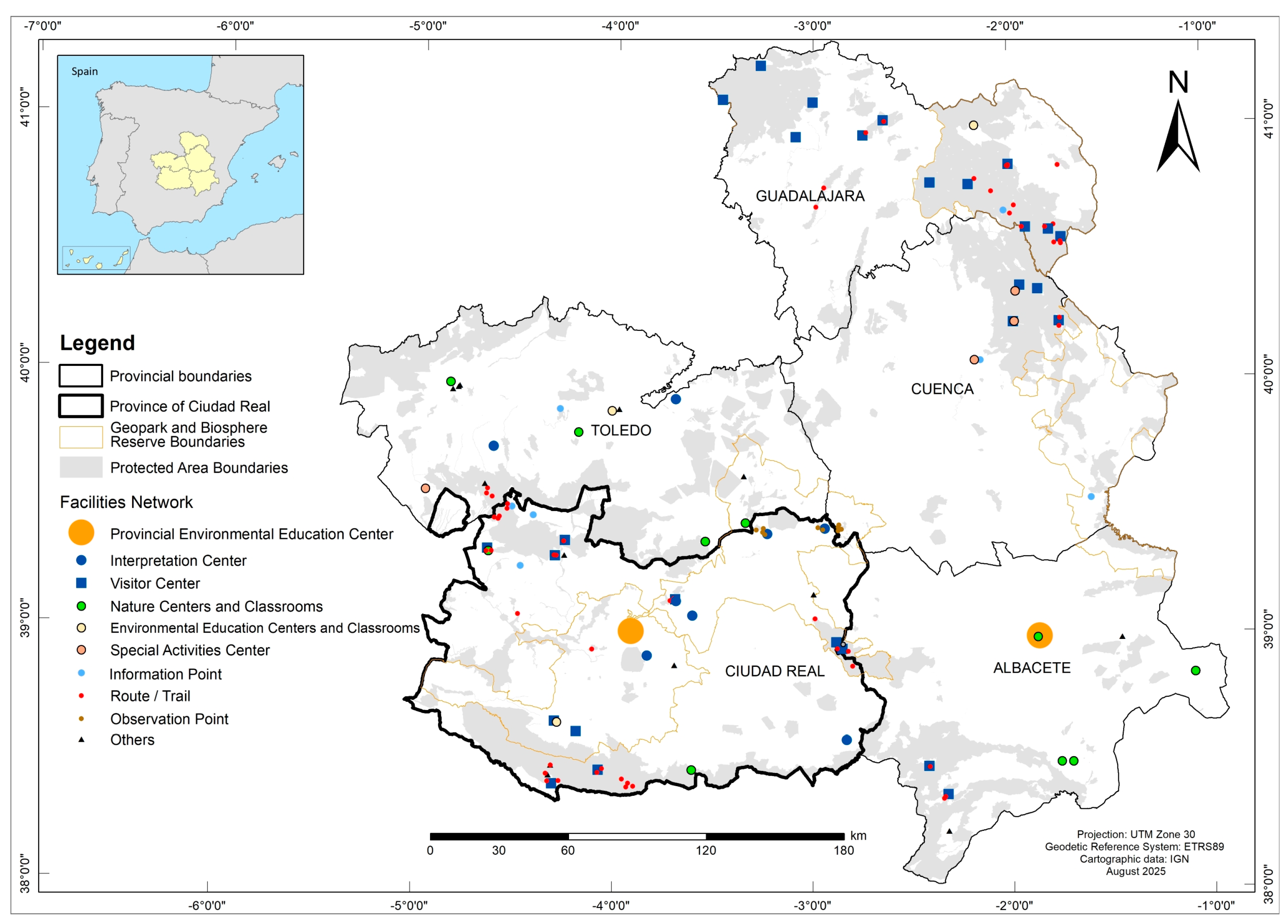
The presence or absence of public facilities and infrastructure (
Figure 2 and
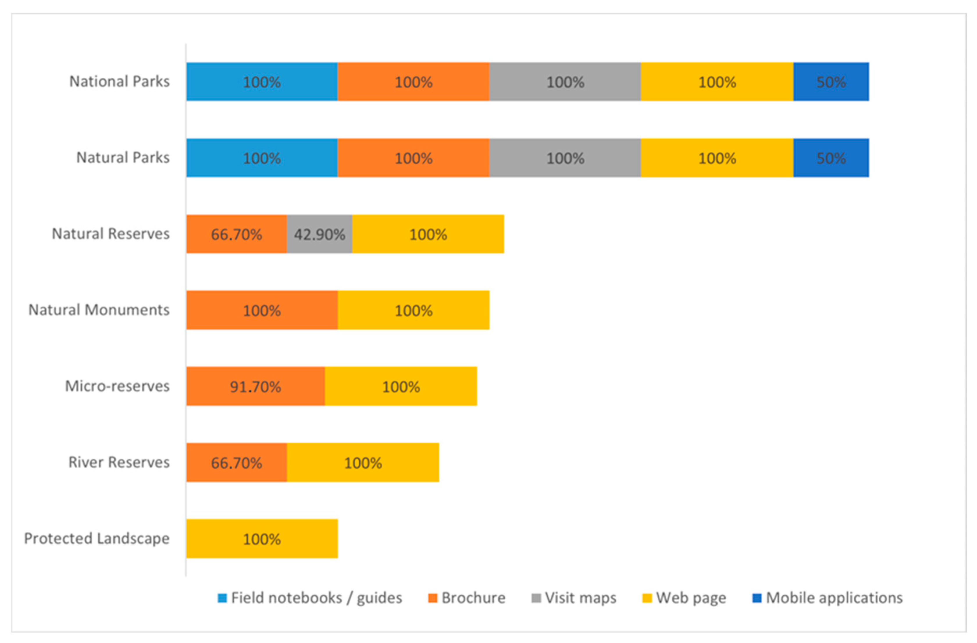
Table 1), institutional information and/or educational materials (
Figure 3 and
Figure 4), as well as the assessment of the accessibility and state of conservation of the various facilities in each PNA (
Figure 5) have been systematically collected for all PNAs studied. This standardised approach allows for the educational capacity of spaces to be compared using criteria that are replicable and consistent with non-formal educational tourism.
According to the regional inventory of educational facilities in PNAs (
Figure 2), Ciudad Real is the best-equipped province in Castilla-La Mancha in terms of diversity and density of facilities. This significant number of public facilities places this inland province of Spain in an advantageous position for the development of tourist-educational activities associated with the enjoyment of multiple resources linked to interpretation centres, visitor centres, information or observation points, or different signposted and interpretive trails, although their distribution follows a pattern clearly conditioned by the importance of the protection status granted to each area. This gradient confirms the influence of protection status on the educational potential of PNAs.
Within the network of protected areas, National Parks and Natural Parks are the most fully equipped. This contrasts sharply with other categories, with the exception of Nature Reserves, some of which—such as the Pedro Muñoz Lagoon Complex—have comparable infrastructure (
Table 1). Of all the components considered, information panels are the most abundant in almost all the PNAs studied, except in the Micro-Reserves, which are clearly the worst equipped. On the contrary, there is a notable shortage of observatories, viewpoints and interpretive trails (except in River Reserves), aspects that particularly condition the development of tourism proposals based on learning about and appreciating the main characteristics of these spaces. These deficits limit the capacity of PNAs to activate interpretive processes and learning experiences based on the landscape.
Of all the aspects covered, it is worth noting the coincidence in the same space of various institutional initiatives that duplicate resources for the promotion or information of certain PNAs. In many cases, this repetition of equipment (easily observable on information panels in many spaces) is poorly coordinated and linked to one-off investments with little subsequent attention. The lack of maintenance and logistical criteria leads to rapid deterioration and a poor image among the public. This dispersion reduces the coherence of the interpretive message and weakens its educational function.
In addition, there has been a notable proliferation of routes and trails developed in recent years, which run through most of the protected areas analysed. Although they are generally classified as “interpretive itineraries,” most do not fully meet this definition, as they merely facilitate the route and provide basic information (e.g., start and end points, distance, travel time). Only in rare cases are they accompanied by facilities—such as panels, signage, or viewpoints—that truly confer an interpretive character suitable for guided or self-guided visits. This situation limits their educational function and confirms the disconnect between the trails on offer and the interpretation standards required for educational tourism.
It is also noteworthy that there are few specific references to landscape considerations in any of the infrastructures analysed. Despite representing an essential explanatory component of the characteristics of these spaces, most of the content of the resources analysed refers to the specific biotic or abiotic components that make them unique. This limited presence of landscape in the interpretive resources identified in numerous PNAs is not only a matter of the specific design of panels or trails, but also reflects a broader structural pattern linked to the way in which public facilities have traditionally been conceived and managed. In many cases, interpretive planning prioritises the communication of thematic elements—flora, fauna, or geology—that are more easily incorporated into small-scale panels and concise messages, relegating landscape approaches that require more complex narratives and specific resources. This thematic bias explains why even areas with outstanding morphological features or visual interest, such as wetlands with closed basins or volcanic units of significant territorial uniqueness, do not translate their landscape potential into adequate interpretive devices. The consequence of this structure is twofold: on the one hand, it limits the visitor’s ability to understand the spatial and functional relationships that articulate the territory; on the other, it wastes a key educational resource for promoting integrated views of the ecological processes, land uses, and historical dynamics that characterise these spaces. This disconnect between landscape potential and interpretive resources reflects the need for planning frameworks that transcend fragmented approaches and consider the landscape as a system, not as a set of isolated elements. Therefore, this widespread deficiency hinders landscape interpretation and impedes the educational enhancement of the landscape as a cross-cutting component, which also represents a major tourist attraction.
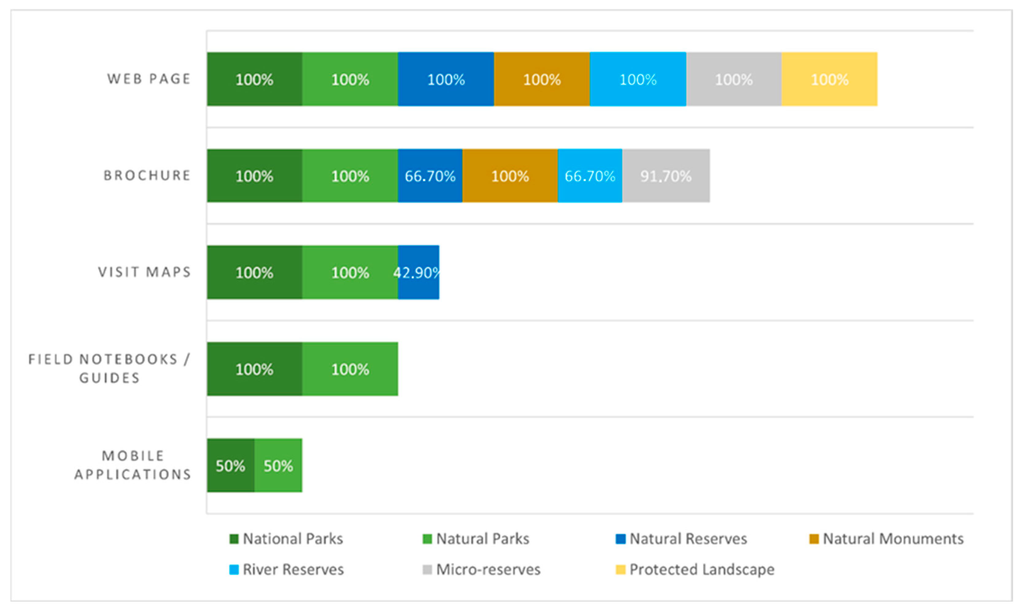
Regarding informational materials, whether printed or digital, specifically linked to each PNA (
Figure 3 and
Figure 4), it is worth noting the effort made by the regional government to provide organised information on all areas on the Protected Areas Network website (
Government of Castilla-La Mancha, 2025). This digital resource provides access to all PNAs, organised by type, with varying levels of information. However, the analysis confirms a very limited presence of interactive tools, mobile applications, and digital guides in most of the PNAs studied. Only National Parks and, to a lesser extent, some Natural Parks offer supplementary digital resources, while the rest of the protected areas lack such digital support. This absence limits the educational potential of the areas. Mobile technologies and digital platforms are key tools for enhancing the tourist experience, facilitating autonomous interpretation, and improving cognitive accessibility for visitors. The low level of digitization observed is therefore one of the most significant shortcomings of the network analysed, highlighting the gap between available interpretive infrastructure and the current demands of non-formal educational tourism.
On the other hand, most of the spaces analysed offer various short printed brochures that provide basic information and brief explanations of their essential characteristics. However, except for the parks, there is a general lack of visitor guides or maps that could enhance the educational tourism experience (
Figure 3).
With specific regard to the distribution of materials by PNA, the main protection categories represented by National and Natural Parks are the only ones that encompass all types of information resources (
Figure 4). In contrast, the remaining areas—except for Nature Reserves—offer only brochures and a presence on the aforementioned institutional website. This represents a new limitation on interpretive potential and reduces the visitor’s tourist experience in terms of building contextualised learning.
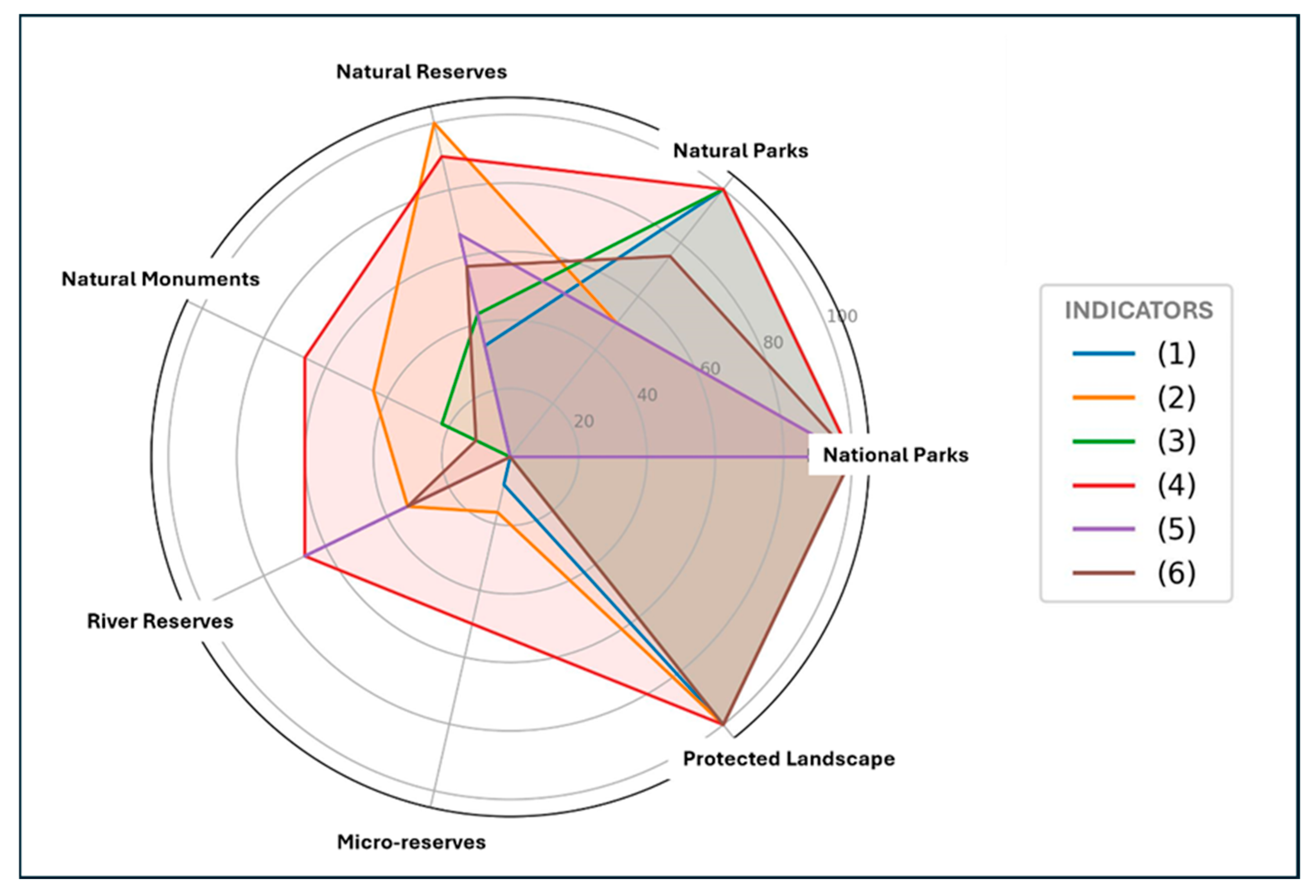
With regard to the accessibility and state of conservation of the identified facilities (
Figure 5), similar behaviour to the characteristics mentioned above has been detected. The investment and care demonstrated in this area by National and Natural Parks is noteworthy, except for the Alcudia Valley and Sierra Madrona Natural Park, whose large size makes its management difficult. The only Protected Landscape in the province is also noteworthy, except for the poor state of conservation of its information panels. In general, insufficient road signage and a lack of parking areas have been observed, along with uneven conditions of interpretive facilities. Only the Laguna del Prado and Alcázar de San Juan Lagoon Complex Nature Reserves, in addition to the Parks, received a good rating on all six indicators considered (see
Figure 5). The rest of the Nature Reserves, together with the River Reserves, show greater variability, with values reaching 0%, while Natural Monuments have the most irregular provision. These differences reflect how accessibility and maintenance directly condition the tourism and educational potential of the PNAs.
Based on the thematic analysis of the components considered, the most consistent variable, although with marked deficiencies in many figures, is the presence of car parks in practically all categories of protection. This is followed by the good state of repair of access roads and local access signage, above the signage for general access from main roads. In all cases, the highest and most representative values are attributed to the largest protected areas (parks), and the lowest values once again coincide with Micro-reserves, due to their small size, more complex accessibility and the variability derived from the high number of declared areas (18). This once again confirms the influence of the protection category on the quality of visiting conditions and, ultimately, on the tourism and educational potential associated with each PNA.
4.2. Classification of PNAs by Educational Tourism Potential
It is assumed that all PNAs have scientific and educational potential and, in most cases, also tourist potential. To clarify this issue, an exercise has been carried out to establish a relationship between the components studied, allowing for a preliminary classification based on the distinction between accessibility processes and resource endowment. With this premise in mind, the ease of access, the uneven distribution, and the state of conservation of resources and facilities in each PNA were considered to identify the main differences between them in terms of tourism and education. This approach makes it easier to identify comparable patterns and assess the actual capacity of each space to activate interpretation and learning processes.
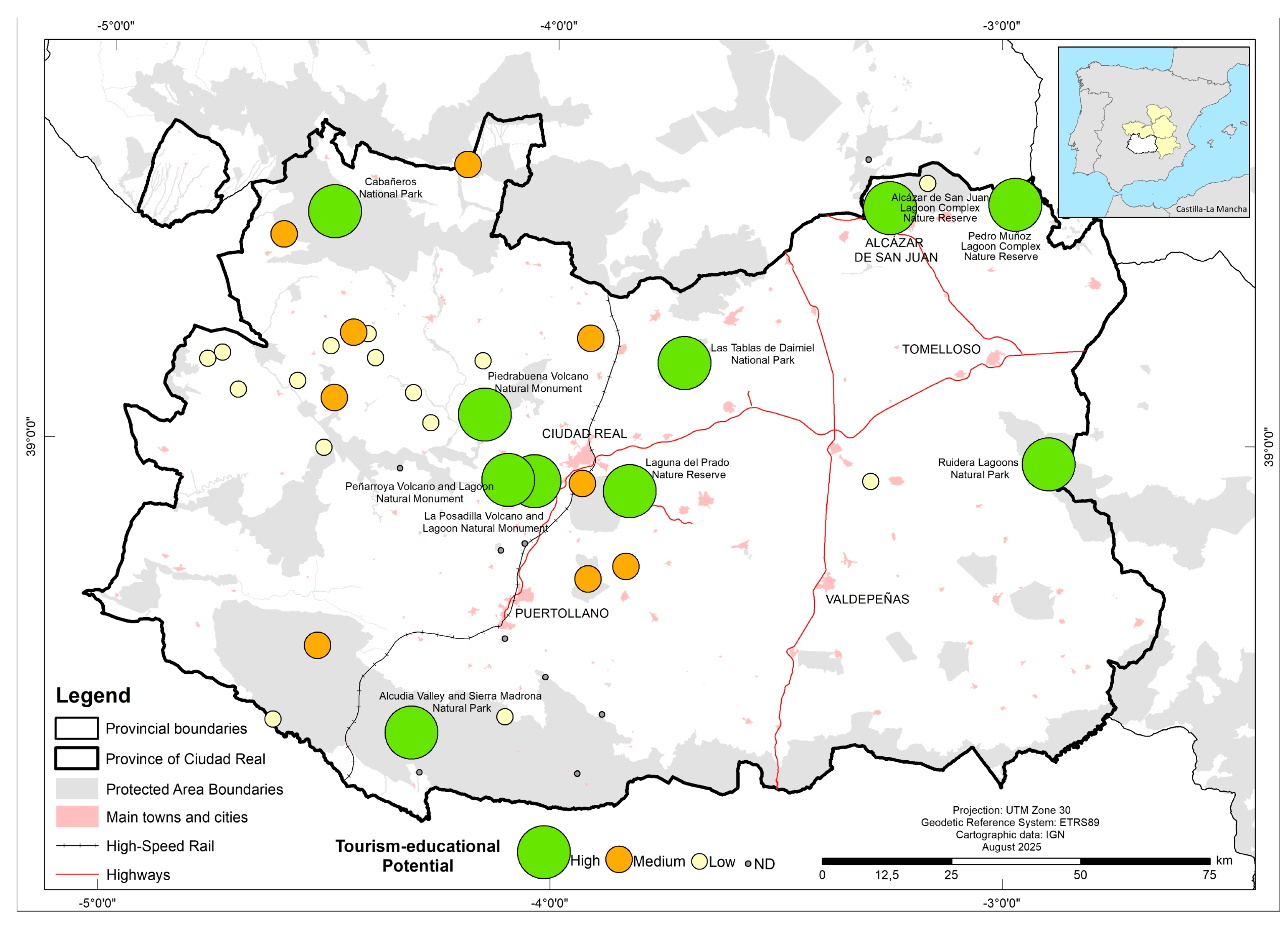
The application of the methodologically proposed basic scale, based on the recurrence and combination of the selected variables (degree of accessibility; presence and state of conservation of infrastructure facilities; and existence of informational/educational resources and materials for tourism purposes), has made it possible to establish a classification of PNAs according to their high, medium or low tourism-educational potential (
Figure 6). This classification synthesises the joint performance of the analysed components and allows for an operational comparison of the suitability of the PNAs for non-formal educational tourism.
Thus, first of all, a group of 10 PNAs in the province of Ciudad Real with high tourism and educational potential has been identified (
Figure 6): the Tablas de Daimiel and Cabañeros National Parks; the Lagunas de Ruidera and Valle de Alcudia y Sierra Madrona Natural Parks; the Laguna del Prado and Alcázar de San Juan and Pedro Muñoz lagoon complexes; and the Laguna and Volcán de La Posadilla, Volcán and Laguna de Peñarroya, and Volcán de Piedrabuena natural monuments. These areas coincide in bringing together a good representation of the three variables considered: they are the ones with the best access signage (in their immediate surroundings and in the PNA itself), they offer visitors the best facilities in terms of interpretive equipment, they have the best maintenance and conservation status of the aforementioned infrastructures, and they have the most resources and informative and educational materials. In most of them, recurring public investment has been detected, aimed at both tourism promotion and environmental awareness and education initiatives (
Government of Castilla-La Mancha, 2025;
JCCM, 2020,
2025), complemented in some cases by state or municipal initiatives. The convergence of these factors explains why these PNAs are classified as having the greatest potential for promoting high-quality educational tourism experiences.
Secondly, a group of nine PNAs with medium tourism and educational potential has been identified. In this case, the River Reserves, Protected Landscapes, and especially Natural Monuments stand out due to their greater number. These areas often lack basic facilities but usually have information and interpretive panels. Similarly, signage at access points is poor on main roads, although more consistent in local areas. In terms of informational materials, brochures and basic maps predominate, with a scarcity of complementary resources. Unlike the previous group, these spaces have lower investment and promotion processes, to the point that some show obvious deterioration of their facilities. Overall, this situation limits interpretive coherence and reduces the capacity of these PNAs to offer fully structured educational-tourism experiences.
Thirdly, a group of 16 PNAs with low tourism and educational potential has been identified. Although all types of protected areas are represented in this group, except for parks and the only provincial protected landscape, most of them (70%) correspond to areas declared as micro-reserves (92% of those studied). These are the smallest areas and have little or no infrastructure and facilities for public use due to their usual location on private properties that are difficult to access. This is compounded by the high ecological fragility of these areas, which discourages interventions that might increase visitor numbers and jeopardise the natural values underpinning their protection. These circumstances result in low perceived value in terms of visitor engagement, due to the limited opportunities for hosting visits and educational activities. Consequently, these areas are among the least known, yet also the most protected from anthropogenic pressures. In this context, their low potential does not imply a lower value but rather highlights the need for alternative educational approaches that respect their ecological and structural limitations.
Although the classification obtained is operational and allows for a clear distinction between the different levels of tourism and educational potential, it should be noted that certain PNAs may fall within the limits of the established categories. This is the case, for example, with some nature reserves or natural monuments, where small variations in some of the criteria used—for example, a specific improvement in road signage, the addition of a new interpretive panel, or the deterioration of a piece of equipment—could move the PNA to a higher or lower category. This sensitivity to small variations reflects the cumulative and hierarchical nature of the evaluation system used and suggests that some areas are close to the threshold between classes. Although these adjustments do not alter the general trends identified, they do highlight the need to consider the dynamic evolution of infrastructure and to periodically update the assessment matrix, especially in PNAs where the availability and state of conservation of facilities vary rapidly, or where recent investments or fluctuations in maintenance have been detected.
All these considerations reveal a direct correlation between a set of determining variables, in particular, the size of the PNA (surface area), the importance of the protection status they enjoy, and the predominance of public or private ownership of the property in which they are located. In general, with a few exceptions, this relationship suggests greater accessibility and provision in larger areas, declared as main protected areas in which public ownership predominates. Therefore, the greatest potential of the PNAs studied is related to National and Natural Parks, 100% of which achieve high values, followed by Nature Reserves (50% of those declared) and Natural Monuments (33.3% of those declared). Low values, in contrast, correspond to smaller areas with minor designations, where private ownership significantly influences accessibility and the provision of facilities. This pattern is evident in the majority of Micro-Reserves and in approximately two-thirds of the Nature Reserves, River Reserves, and Natural Monuments studied.
Overall, the main tourist and educational attractions that received the highest ratings are centred on the established presence of cultural and nature tourism. These include outstanding examples of Mediterranean forest and associated fauna; various wetlands linked to river tables, lagoons with barriers and terraces, and seasonal water bodies conducive to bird watching and observation of associated vegetation; and diverse volcanic morphologies. The remaining areas, except for those that are more fragile or under private ownership, could also achieve high ratings if accessibility limitations are addressed, facilities are improved, and additional interpretive information highlighting their natural and educational values is provided. They can also qualify if activities associated with educational tourism processes related to the creation or reinforcement of specific programmes are encouraged.
Finally, it is noteworthy that there are few specific references to landscape considerations in any of the facilities analysed. Although this concept is an essential component in explaining the appeal and understanding of PNAs, most of the content in the resources analysed focuses on specific biotic or abiotic components that make them unique from a protection perspective. With the exception of certain areas with high potential for appreciation—where some resources along trails or specific sites highlight panoramic views as outstanding visual attractions—there remain few direct references to landscapes. These references are even scarcer when they refer to the understanding of their internal structure, or their functioning and main problems. These aspects would help reinforce the responsible dimension of educational tourism potential in these areas, as they constitute key instruments for fostering critical and engaged tourism.
5. Discussion
It has been demonstrated that the abundance and quality of interpretive facilities are not only an operational element but also a determining factor in the tourist appeal and competitiveness of destinations, especially for visitors who are interested in learning during their visit (
Marion & Reid, 2007;
Cebrián, 2013;
Navrátil et al., 2015;
Oviedo-García et al., 2019, among others). Adequate provision and maintenance of these resources increases the quality of the experience, satisfaction and the likelihood of choosing the destination. In addition, a coherent network of interpretive infrastructure prolongs the length of stay and diversifies use by promoting demand for complementary tourist-educational activities and resources (
Navrátil et al., 2015;
Garzón-García & Ramírez-López, 2018;
Jerez & Serrano de la Cruz, 2025).
The development of educational tourism initiatives therefore requires adequate and maintained infrastructure, dependent on the managing bodies of the PNAs (
Blanco Cerradelo et al., 2015;
Fernández & Ramos, 2015;
Garzón-García & Ramírez-López, 2018;
Maga & Nicolau, 2018;
Bahamonde-Rodríguez et al., 2023). Its promotion should also involve local actors in the design of interpretive routes, educational activities, or volunteer programmes, as this strengthens social capital and reinforces a sense of belonging to the territory (
Hernández-Morcillo et al., 2013). This is particularly relevant in rural and peripheral areas, where educational tourism can act as a key territorial development tool within the framework of sustainability processes.
On this conceptual basis, we interpret the results in terms of the educational capacity and interpretative coherence of the network evaluated. The analyses confirm the initial hypothesis and highlight the heterogeneity in terms of facilities and conservation among PNAs, which hinders the development of tourist-educational activities in many of them. This structural inequality between protection figures reflects limitations in funding and maintenance, already recognised in other studies (
Bahamonde-Rodríguez et al., 2022,
2023). Among the resources analysed, interpretive itineraries remain the most effective devices for promoting knowledge and awareness, especially when designed according to landscape criteria (
García de la Vega, 2004;
Batllori Obiols & Serra i Sala, 2017;
Cano-Ortiz et al., 2025). The scarcity of these trails in the network analysed is a key limitation, affecting not only the available inventory but also public use, the visitor experience and the need for specialised staff for their proper management.
Likewise, the scarce presence of digital resources observed in the PNAs analysed represents a significant limitation for the development of educational tourism, especially in a context in which mobile technologies and interactive platforms have become established as key tools for enriching autonomous interpretation and the visitor experience. Recent studies highlight that digitisation is an essential complement to traditional equipment, as it improves cognitive accessibility and promotes more flexible and personalised learning (
Beato et al., 2024;
Parra-Sánchez & Viviescas-Jaimes, 2024;
Sahahiri, 2025). Therefore, the current limited implementation of these tools highlights the need to incorporate them into future tourism and educational planning strategies.
A key aspect—and distinguishing feature—of this study is the effective integration of landscape as an operational criterion for interpretive design. The results show, however, that landscape significance is limited in the tourism-education resources analysed, despite being an essential heritage component with high educational value (
Cebrián, 2013;
Casas et al., 2017;
Salinas et al., 2019;
Geng et al., 2025). Landscape is often linked mainly to aesthetic appreciation (
Kastenholz et al., 2018) or recreational enjoyment (
Devesa et al., 2010), relegating it to a mere visual backdrop rather than a central object of the tourist or interpretive experience. This restricted view is particularly problematic in protected areas with exceptional characteristics, where the landscape is a fundamental resource for promoting spatial and ecological understanding of the territory (
Batllori Obiols & Serra i Sala, 2017;
Liceras, 2017). This tourism-oriented conception of landscape makes it difficult to clearly situate it within the range of resources or products associated with specific tourism typologies, thereby hindering the subsequent development of planning or intervention diagnoses for both established destinations and emerging initiatives.
Although the landscape is a key element of natural heritage and a privileged setting for experiential education, its actual integration into tourism-education planning remains uneven and, in many cases, insufficiently implemented (
García de la Vega, 2004;
Liceras, 2013). To move towards a more holistic use of landscape in educational tourism, it is necessary to incorporate analytical frameworks that evaluate not only its biophysical or aesthetic attributes, but also its capacity to structure integrative narratives about ecological processes, historical dynamics and sociocultural practices linked to the territory (
Batllori Obiols & Serra i Sala, 2017;
Beery, 2025). In this vein, the incorporation of specific landscape-related indicators (such as the existence of observation points, the presence of landscape content on interpretive panels, or visual accessibility to significant landscape units) makes it possible to move beyond overly descriptive approaches and advance toward more integrated and comparable assessments (
Liceras, 2017;
Salinas et al., 2019). The adoption of this type of indicator, combining qualitative and quantitative approaches, contributes to assessing the real capacity of PNAs to integrate landscape-based interpretive approaches and to strengthening the role of landscape as an educational mediator and cross-cutting analytical tool, favouring more robust and transferable diagnoses.
The simplified tourism-education potential model based on interpretive facilities makes it possible to clearly identify the main shortcomings of each PNA and guide interventions aimed at strengthening them (
Blanco Cerradelo et al., 2015). Although the proposal is considered relevant for tourism and education planning, other studies also emphasise the importance of considering other more applied measures. These include those that address market planning and segmentation, visitor experience management, and product quality, which are more typical of strategic tourism tools (
Ritchie, 2003;
Pitman et al., 2010;
Fernández & Ramos, 2015). Also noteworthy are those that link resources to the existence of specific temporary programmes or activities that may benefit this tourism practice, as evidenced by recent initiatives implemented in the territory analysed (
JCCM, 2020,
2025;
Government of Castilla-La Mancha, 2025). Consequently, the improvement of interpretive resources must be understood in relation to complementary strategies that integrate communication, educational programming and tourism management.
These guidelines must be refined through specific analyses by PNA, given that good interpretive resources alone do not guarantee increased tourist numbers, as structural, market and management factors influence their actual use (
Garzón-García & Ramírez-López, 2018;
Bahamonde-Rodríguez et al., 2022). These include external accessibility, the visibility of the destination, competition with mature enclaves that favour ‘satellisation’ processes (
Troitiño & Troitiño, 2018), as well as maintenance problems, regulatory constraints, a lack of complementary services, and poorly differentiated interpretive narratives (
Garzón-García & Ramírez-López, 2018;
Bahamonde-Rodríguez et al., 2023). All of these factors highlight the importance of adequate planning and consistency in the maintenance or enhancement of these investment networks.
Logically, the effectiveness of educational tourism in promoting sustainability depends largely on the quality of the initiatives, their associated programmes and their alignment with local values in the areas of influence of the PNAs. It should also be borne in mind that tourism in these types of areas must be properly planned and contained, given their fragility. Beyond incorporating environmental content, it is essential to design coherent and well-contextualised proposals that are tailored to different audiences and capable of generating a lasting impact on visitors. In this regard, alongside the provision of adequate infrastructure and up-to-date interpretive resources, the training of guides, educators, and staff at these destinations is also essential (
Marion & Reid, 2007;
Moore et al., 2013).
These findings should be interpreted in light of several constraints and limitations of the study. Although this study has deliberately focused on the endowment and operational variables of PNAs, the literature shows that the real potential of educational tourism depends largely on the characteristics of demand and visitor profiles. Previous studies have shown that motivations, educational expectations and environmental perceptions directly influence destination choice, the degree of use of interpretive resources and the acquisition of meaningful learning (
Ritchie, 2003;
Falk, 2005;
Ballantyne & Packer, 2011). It has also been found that visitors to natural environments exhibit different behaviours and levels of involvement depending on their interests, previous experiences, and sensitivity to sustainability (
Devesa et al., 2010;
Kastenholz et al., 2018). The absence of these dimensions in our analysis is a significant limitation, as it prevents us from relating the current provision of PNAs to the real needs and expectations of visitors.
The evaluation carried out is only part of the analysis needed to understand the tourist-educational use of PNAs and must be complemented by additional approaches. The selection of variables used, focused on infrastructure and interpretive materials, limits a comprehensive view of the educational experience, whose determinants include pedagogical, demand and behavioural factors. The literature highlights the need to study the effective pedagogical value of resources (
Ardoin et al., 2020), to delve deeper into the profiles, motivations and conditioning factors of visits through surveys and socio-cultural analyses (
Ritchie, 2003;
Wang & Li, 2008;
Devesa et al., 2010) and evaluating the intention of educational behaviour, related to the probability of future learning-oriented visits (
Ballantyne & Packer, 2011;
Moore et al., 2013;
McGladdery & Lubbe, 2017). These lines of work would allow for better contextualisation of the tourism-educational potential of PNAs and progress towards more comprehensive and applied models of planning and management.
Taken together, the patterns identified allow us to move towards a more analytical reading of the relationship between infrastructure, interpretive mediation and learning, beyond the mere observation of deficits or availability. Thus, the concentration of coherent interpretive resources in certain protection figures confirms the thesis of
Navrátil et al. (
2015) that the quality and density of interpretive devices condition not only visitor satisfaction but also the cognitive depth of the experience. Similarly, the fragmentation detected in many PNAs—isolated panels, signposted but non-interpretive trails, lack of maintenance—coincides with the limitations pointed out by
Munro et al. (
2008) and
Oviedo-García et al. (
2019), who argue that the disconnect between devices compromises the construction of meaning and reduces the effectiveness of learning in non-formal contexts. These parallels allow us to affirm that the results of the present study are not contingent on the territory analysed, but rather align with broader trends documented in the international literature on educational management in protected areas.
Based on this evidence, an operational conceptual framework can be formulated that synthesises the educational conditions of PNAs in three interrelated dimensions: (1) spaces with consolidated interpretive infrastructure, characterised by a diversified, coherent and well-maintained offering that facilitates structured educational experiences; (2) spaces with partial provision, where basic but fragmented interpretive resources exist, allowing for specific learning but with limited conceptual depth; (3) and under-equipped spaces or those with structural limitations, whose reduced accessibility, lack of resources and ecological fragility condition educational development, restricting learning opportunities to specific and highly contextualised interventions. In all of them, the landscape depth of mediation plays a decisive role, understood as the capacity of the facilities to activate spatial and systemic readings of the territory. This typology, although derived from the case study, is based on replicable criteria and provides a comparative framework applicable to other regional PNA networks.
This framework ultimately allows the findings to be placed within broader debates. In relation to educational tourism, the results show that the effectiveness of learning does not depend solely on activities or programmes, but also on the structural conditions of the destination, as pointed out by
Ritchie (
2003) and
McGladdery and Lubbe (
2017). In terms of heritage interpretation, the evidence confirms the importance of museographic and narrative coherence highlighted by
Tilden (
1957) and
Ham (
1992), showing that interpretive fragmentation limits knowledge transfer and the significance of the experience. Finally, the study provides empirical evidence for debates on landscape-based learning, reinforcing the idea defended by
García de la Vega (
2004),
Liceras (
2013,
2017) and
Batllori Obiols and Serra i Sala (
2017) that landscape is a cognitive mediator of the first order. The finding that it is rarely present in the facilities analysed reveals a structural gap that has not been sufficiently documented, and which this study helps to highlight and operationalise.
6. Conclusions
The research confirms a remarkable provision of interpretive facilities and resources in the PNAs of the province of Ciudad Real, although their distribution is clearly uneven and dependent on the type of protection. National and natural parks have the greatest diversity and quality of infrastructure, while smaller protected areas have significant shortcomings that limit their tourist and educational potential. Information panels, interpretation centres and marked trails are the most common resources, although the presence of proper interpretive trails remains limited, which restricts the educational potential of many areas.
Likewise, there is a generalised shortage of specialised information resources, especially in digital formats or more in-depth guides. Although there is significant public investment (plans or programmes for economic revitalisation and environmental dissemination and education in different areas), this does not always translate into comprehensive planning that improves the coherence and maintenance of the network of facilities and boosts this type of tourism. In addition, the assessment carried out shows three levels of tourism-educational potential based on accessibility, interpretive facilities and the state of conservation of the infrastructure, revealing patterns linked to the surface area of the PNA, its protection status and the type of ownership.
A particularly relevant element of the analysis is the finding of a structural landscape gap: the integration of landscape into facilities, interpretive materials and educational devices remains very limited. Given that landscape is a key educational resource for articulating systemic readings of the territory and promoting experiential learning, its absence significantly reduces the educational capacity of many PNAs. Strengthening landscape content—both on panels and viewpoints and in itineraries and digital resources—is therefore a priority for consolidating the tourism and educational potential of these spaces.
Although the analysis was carried out in a limited regional area, several components of the methodology used are universal in nature and can be transferred to other protected natural areas. These include the approach based on systematic inventories of interpretive facilities and resources, the assessment of the state of conservation of public infrastructure, and the joint consideration of accessibility, interpretive provision, and availability of informational materials as key variables for diagnosing tourism and educational potential. However, other aspects depend on the particularities of the regional context analysed, such as the marked heterogeneity in the territorial distribution of the PNAs, the coexistence of very diverse protection figures, and the weight of private property in certain categories. Consequently, although the methodology offers a solid framework that can be replicated in other territories, the specific interpretation of the results must be adapted to the administrative, territorial, and management realities of each region.
From an applied perspective, the results suggest the need to optimise the installation, consistency and maintenance of public facilities, avoiding duplication and making existing devices more functional. Similarly, it is advisable to prioritise interpretive interventions from strategic locations, incorporating the landscape as a connecting thread. Strengthening collaboration between public and private entities could help to boost tourism and educational activities based on sustainability and learning criteria.
In terms of education, it is advisable to promote public use for educational purposes through coordinated campaigns and greater integration with school calendars, ensuring continuous use of the infrastructure. Future research should delve deeper into visitor perception and motivation, as well as the real educational value of the resources, in order to move towards more comprehensive models of educational tourism planning in protected areas.