Article

Ecological Risk Assessment of Metal Contamination in Groundwater and Sediments Along the Ruta de los Cenotes, Mexican Caribbean

by
Gabriela Pineda-García
1,
Jorge Adrián Perera-Burgos
2,*,
Ana K. Celis
3,
Yanmei Li
4,
Jesús Horacio Hernández-Anguiano
5,
Guillermo de Anda-Alanis
6,
Rosa María Leal-Bautista
1,
Ignacio Alejandro Pérez-Legaspi
7 and
Jesús Alvarado-Flores
1,*
1
Water Sciences Unit—Scientific Research Center of Yucatán A.C., Calle 8, No. 39, Mz. 29, Sm. 64, Cancún C.P. 77524, Quintana Roo, Mexico
2
SECIHTI—Department of Mining, Metallurgy and Geology Engineering, University of Guanajuato, Ex Hacienda de San Matías S/N, Guanajuato C.P. 36020, Guanajuato, Mexico
3
Karst Lab México, Mz. 32, Sm. 24, Cancún C.P. 77509, Quintana Roo, Mexico
4
Department of Mining, Metallurgy and Geology Engineering, University of Guanajuato, Ex Hacienda de San Matías S/N, Guanajuato C.P. 36020, Guanajuato, Mexico
5
Department of Geomatic and Hydraulic Engineering, University of Guanajuato, Av. Juárez No. 77, Guanajuato C.P. 36000, Guanajuato, Mexico
6
Cancún Maya Museum, National Institute of Anthropology and History, Boulevard Kukulcan Km. 16.5, Zona Hotelera, Cancún C.P. 77500, Quintana Roo, Mexico
7
Instituto Tecnológico de Boca del Río, Tecnológico Nacional de México, Carretera Veracruz-Córdoba km. 12, Boca del Río C.P. 94290, Veracruz, Mexico
*
Authors to whom correspondence should be addressed.
Earth 2026, 7(5), 151; https://doi.org/10.3390/earth7050151
Submission received: 9 July 2026 / Revised: 3 September 2026 / Accepted: 8 September 2026 / Published: 14 September 2026

Abstract

Metal contamination in karst aquifers is a growing concern in rapidly urbanizing coastal regions. The Ruta de los Cenotes in Quintana Roo comprises groundwater-fed cenotes of high hydrogeological and ecological relevance. This study characterized the hydrogeochemical setting of five cenotes along a coastal–inland gradient, quantified metals in groundwater and sediments, and assessed ecological risk. Groundwater was sampled at 1, 15, and 25 m during dry and rainy seasons, and sediments at 30 m depth. Metals (Al, Ba, B, Cd, Cr, Cu, Fe, Li, Ni, Pb, and Zn) were determined by ICP-OES. Coastal and transitional cenotes showed calcium-sulfate waters and EC > 1200 µS/cm, whereas inland cenotes showed calcium-bicarbonate waters and EC < 1000 µS/cm. Multivariate analysis identified mineralization gradients during the dry season and site-specific variability during the rainy season. In groundwater, Al reached 0.487 mg/L in A-Ha, exceeding the NOM-127-SSA1-2021 limit of 0.20 mg/L. Al, Fe, Li, Cu and Zn were the main contributors to high ecological risk, with Al (RA = 3043.75) and Fe (RA = 74.15) showing the highest values during the rainy season. Overall, risk rankings differed seasonally, with Li > Cu > Zn > Fe > B > Ba in the dry season and Al > Fe > Zn > Cu > Cr in the rainy season. Sediment-associated ecological risk was highest at one coastal cenote (RI = 1868.66), driven mainly by Cd (2.17 mg/kg). These results provide quantitative information that can support future assessments and monitoring of metal-related vulnerability in karst ecosystems.

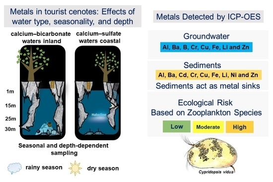
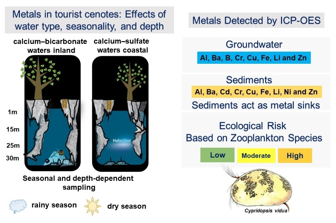
Graphical Abstract

1. Introduction

Groundwater in the Yucatán Peninsula is a vital resource for millions of residents and tourists in the states of Quintana Roo, Campeche, and Yucatán. The regional aquifer system is developed within highly permeable carbonate rocks, characterized by extensive fracturing and dissolution features that promote rapid groundwater flow and strong hydraulic connectivity between surface and subsurface environments [1]. The absence of surface drainage, thin and discontinuous soil cover, and limited natural attenuation capacity facilitate contaminant entry and transport, rendering the karstic aquifer system highly vulnerable to anthropogenic pollution [2]. In this regional hydrogeological framework, local pressures from land use and urban development play a critical role in controlling groundwater quality.
The state of Quintana Roo, located on the eastern edge of the Yucatán Peninsula, is experiencing rapid urban growth. This growth is driven by the expansion of major coastal tourist cities like Cancún, Playa del Carmen, and Tulum, which play a significant socioeconomic role in the country. In this setting, the Ruta de los Cenotes (RC) constitutes an important inland corridor. It extends about 35 to 50 km from the municipal center of Puerto Morelos to Leona Vicario, along the boundary of Lázaro Cárdenas. The region is notable for its high concentration of sinkholes, locally called cenotes, which come from the Mayan word d’zonot. These cenotes provide direct access to groundwater and are common features in karstified carbonate terrains. Some cenotes are connected by flooded underground dissolution-conduits, forming highly heterogeneous groundwater systems.
Cenotes are important for both their ecological and cultural value. Recently, they have attracted a lot of tourist activity. The area is well-known for activities like aquatic tourism, recreational diving, camps, and real estate development. The modernization of southeastern Mexico has changed the economic and cultural life in this region [3]. This change has led to more pressure on natural resources, the rise of informal settlements, an increase in forest fires, and a higher risk of water pollution. Additionally, the construction of a Maya Train station in Puerto Morelos has brought railway traffic through the Cancún–Tulum hydrogeological reserve. This project adds more human-made pressure to the karst aquifer system. The region also deals with overloaded urban infrastructure. There is no formal system for collecting urban solid waste, and there are no wastewater treatment plants. Most domestic wastewater is managed with septic tanks.
Under these conditions, and without proper planning amid rising environmental pollution, Puerto Morelos is likely to face more severe shortages of high-quality drinking water. This may lead to serious environmental and public health issues. The situation is a growing environmental concern that could worsen if current practices continue, putting the long-term sustainability of the region’s economic growth at risk. While tourist activities bring economic benefits, they may harm the aquifer by introducing chemical contaminants, like metals, into sediments and groundwater, potentially leading to adverse ecological effects [4].
Several studies have shown that groundwater quality is declining and contamination is increasing in the Yucatán Peninsula. For example, Arcega et al. [5] found Pb in wetlands of Yucatán, whereas Medina et al. [6] reported hydrocarbon contamination in cenotes of Quintana Roo, with levels closely tied to tourist seasons. Gonzalez et al. [7] pointed out that tourism, fishing activities, and open-air dumping sites are key sources of metal pollution. Even though municipal dumps have closed, leftover leachate and illegal dumping sites still create environmental risks.
More recent investigations have confirmed the presence of heavy metals in cenotes within the RC. Alvarado-Flores et al. [8] found Cd and Hg in biota from northeastern Quintana Roo. Pérez-Yañez [9] reported Cd in both biota and groundwater at levels exceeding Mexican regulatory limits. Likewise, Benavides et al. [10] detected Cd, Cr, and Pb in the water column of a cenote in Puerto Morelos.
While these studies have shown the presence of contaminants in cenote environments, most research has targeted specific environmental parts or individual contaminants. There are few comprehensive assessments that look at total recoverable metals, metals in sediment, sediment enrichment, geoaccumulation indices, hydrogeochemical changes, and ecological risk across different seasons and areas in the Yucatán Peninsula karst aquifer. Specifically, we still do not fully understand how hydrogeochemical conditions, groundwater connections, and coastal–inland gradients affect the presence, buildup, and possible ecological effects of metals in cenote ecosystems.
In karst aquifers, hydrogeochemical processes like groundwater mixing, redox stratification, seawater influence, and water–rock interactions strongly control metal mobility and bioavailability. This means that understanding metal presence requires measuring dissolved concentrations and considering the hydrogeochemical framework that affects how contaminants move and change. Also, analyzing sediment offers an additional perspective for assessing metal accumulation patterns and possible contamination history. This is especially true in situations where dissolved concentrations might fluctuate seasonally or stay below detection limits. In this setting, multivariate statistical methods provide a helpful way to identify hydrogeochemical gradients, group samples with similar physicochemical characteristics, and assess how seasonal changes and coastal–inland differences affect groundwater composition.
In addition to current anthropogenic pressures, projected climate change presents a new challenge for the Yucatán Peninsula karst aquifer. Rising sea levels and changes in recharge patterns are expected to worsen seawater intrusion and alter redox conditions in coastal and nearby groundwater systems. This could lead to increased metal mobilization and bioavailability [11]. In these scenarios, cenotes may undergo shifts in hydrogeochemical layers and contaminant behavior, which raises ecological vulnerability. Therefore, establishing strong hydrogeochemical and ecological baselines is essential for predicting future changes in groundwater quality and how ecosystems will respond to rising salinity and climate variability. While people often refer to regulatory standards to assess water quality, meeting drinking-water criteria does not guarantee there is no ecological risk. Aquatic organisms may be more sensitive than human-health-based thresholds, particularly in groundwater-dependent ecosystems where endemic communities are exposed to long-term contaminant inputs. Therefore, ecological risk assessments based on predicted no-effect concentrations (PNECs) offer an added approach to evaluating potential biological impacts and spotting at-risk environments before ecological damage becomes obvious.
In response to concerns from local communities and service providers along the Ruta de los Cenotes, this study assesses metal contamination in groundwater-dependent ecosystems. The specific objectives were to: (i) characterize the hydrogeochemical facies and physicochemical gradients of selected cenotes; (ii) quantify total recoverable metals and sediment-associated metal concentrations and evaluate their spatial, vertical, and seasonal changes; (iii) apply multivariate statistical analyses to identify hydrogeochemical gradients and sample groupings related to seasonal changes and the coastal–inland transition; (iv) assess ecological risk in groundwater using PNEC-derived thresholds; and (v) evaluate sediment metal enrichment, geoaccumulation, and potential ecological risk using the enrichment factor, geoaccumulation index, and Hakanson RI methods. Overall, this study sets a precautionary baseline for assessing metal-related vulnerability in a karst aquifer system. It also supports the development of long-term environmental monitoring and sustainable groundwater management strategies in the Yucatán Peninsula.

2. Study Area

At the regional scale, the Yucatán Peninsula aquifer is recharged predominantly by meteoric infiltration. Because perennial surface drainage is scarce over much of the carbonate platform, rainfall infiltrates through thin soils and epikarst and then through fractures and dissolution conduits. Cenotes therefore function primarily as direct windows into the groundwater system rather than as isolated surface-water bodies. Groundwater is transmitted through the highly permeable carbonate aquifer toward coastal discharge zones, including springs and submarine groundwater discharge along the Caribbean margin [2,12,13]. This groundwater resource supports regional domestic and public-water needs, tourism, and groundwater-dependent ecosystems; however, the individual cenotes sampled in this study were evaluated as environmental monitoring sites and were not characterized as production wells.
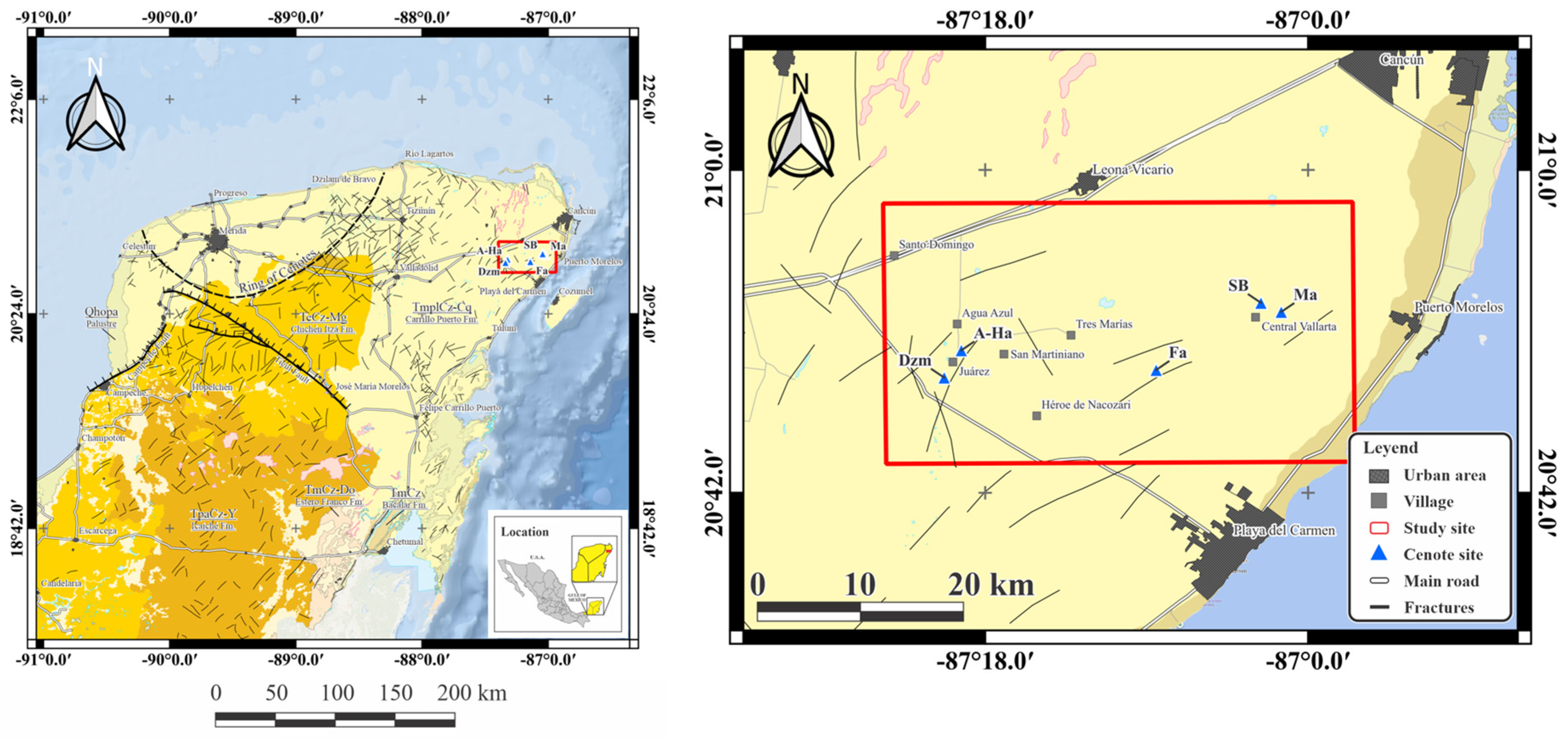
Within this regional hydrogeological setting, the study area is located along the Ruta de los Cenotes, in northeastern Quintana Roo, Mexico (Figure 1). The region is characterized by a tropical sub-humid climate, with mean annual temperatures ranging from 24 to 28 °C. Precipitation is markedly seasonal, with a rainy period from May to October and a dry season from November to April. Average annual precipitation ranges between approximately 1000 and 1300 mm, with intense rainfall events associated with tropical storms and hurricanes. These climatic conditions exert a strong control on groundwater recharge, flow dynamics, and contaminant transport within the regional karst aquifer system.
The cenotes studied along the Ruta de los Cenotes include Cenote Maravilla (Ma), Cenote Siete Bocas (SB), Cenote Fátima (Fa), Cenote Azul-Há (A-Ha), and Cenote Dzalam (Dzm). These cenotes encompass diverse morphologies and hydrogeological contexts, ranging from open to semi-open systems. According to the morphometric classification of Hall [14], Dzm is classified as an open “vertical walls” type. In contrast, Ma, SB, Fa, and A-Ha are classified as semi-open “jug or pit”-type cenotes, characterized by surface connections that are narrower than the diameter of the underlying water body. Although these cenotes share a broad karstic origin, each site displays distinct morphological and hydrogeological features.
SB contains several collapse openings that allow interaction between surface conditions and the submerged karst system, favoring light penetration and exchange with the surrounding aquifer. However, detailed hydrogeochemical information for this site remains limited. Fa represents a typical cenote formed by subsurface karst development; however, precise hydrogeological and geochemical characterization is still scarce. Similarly, for Dzm and A-Ha, available information is largely limited to general morphological observations, and detailed hydrogeological descriptions remain scarce.
In contrast, Ma is a deep jug-type cenote where strong vertical stratification has been documented, including the presence of a hydrogen sulfide (H2S) layer below 26 m depth and the occurrence of subaqueous biogenic speleothems known as Hells Bells, which appear at water depths from ~19 to at least 32 m [15]. These subaqueous structures, first detailed in the region at sites like Cenote Zapote and Cenote Tortugas [16], grow underwater and exhibit laminar fabrics composed of alternating calcite units. Although alternative hypotheses exist, the model proposed by Ritter et al. [17] is currently the most widely supported, linking their formation to specific hydrogeochemical conditions at a pelagic redoxcline above a sulfidic halocline, where biologically induced authigenic calcite precipitation occurs. The presence of Hells Bells in Ma suggests that this cenote meets key conditions for their formation, including water-column stagnation and sufficient organic matter input to promote anoxic conditions near the halocline, further underscoring its stratified nature.
Because the degree of subsurface characterization differs among the selected cenotes, detailed geometries of submerged chambers, conduits, and hydrogeochemical interfaces cannot be generalized to all sites. Representative photographs, morphological illustrations, and hydrogeological cross-sections of cenotes from the northeastern Yucatán peninsula are available in Hall [14], Stinnesbeck et al. [16], Ritter et al. [17] and Schorndorf et al. [15]. These studies provide complementary visual documentation of open and semi-open cenote morphologies, submerged karst cavities, freshwater–saline groundwater stratification and, where present, halocline and redoxcline development associated with Hells Bells-bearing systems.
Together, these cenotes illustrate the hydrogeological heterogeneity of karst systems along the Ruta de los Cenotes and provide an appropriate framework for evaluating spatial and seasonal variability in groundwater chemistry and metal distribution. Differences in morphology, degree of vertical connectivity, and proximity to the coastline are expected to influence groundwater residence times and the development of hydrogeochemical and redox gradients within the cenote systems.
The imperative for comprehensive protection is further magnified by the role of these cenotes as irreplaceable repositories of paleontological and archaeological history. The sinkholes along the Ruta de los Cenotes have yielded a stratified record of life, spanning from Miocene-era Otodus megalodon fossils and Pleistocene megafauna to pre-Columbian Mayan archaeological remains, including human skulls and ceramic artifacts. Therefore, maintaining the hydrogeochemical integrity of the aquifer in this region is relevant not only for water security and ecological protection but also for preserving unique archives of geological, biological, and cultural history. Independent field samples were collected at three depths (1, 15, and 25 m) in each of the five cenotes during one dry-season and one rainy-season campaign. This design allowed us to assess spatial differences among cenotes and depths, while recognizing that each season was represented by a single sampling campaign.

3. Materials and Methods

3.1. Water and Sediment Collection

This study was carried out during the rainy season (October 2021) and the dry season (March 2022) in cenotes Ma, SB, Fa, A-Ha, and Dzm along the Ruta de los Cenotes (see Figure 1). At each site, 1 L water samples were collected at three depths (1, 15, and 25 m) using a Van Dorn bottle. Prior to field sampling, the high-density polyethylene (HDPE) bottles used for water collection were cleaned in accordance with United States Environmental Protection Agency (USEPA) protocols. Containers were washed with a phosphate-free detergent, rinsed with deionized water, soaked in a 10% hydrochloric acid solution for 24 h, and finally rinsed again with deionized water.
Physicochemical parameters, including temperature (°C), pH, electrical conductivity (EC), oxidation-reduction potential (ORP), and total dissolved solids (TDS), were measured in situ using a HANNA multiparameter probe (model HI98129, Hanna Instruments, Inc., Woonsocket, RI, USA). Water samples were stored in a cooler and transported to the laboratory. Upon arrival, 125 mL subsamples were taken from each 1 L sample for chemical analysis. For major ion determination, samples were filtered through 0.45 µm Millipore Millex-HN membrane filters (Millipore Corporation, Burlington, MA, USA). For total recoverable metals analysis, separate aliquots were acidified to pH = 2 with ultrapure nitric acid (HNO3). All water samples were stored at 4 °C until further analysis.
Sediment samples were collected in the cenotes at a depth of approximately 30 m with the assistance of certified cave divers from the Gran Acuífero Maya. Plastic sampling tools were used, including a 30 cm shovel, 25 × 25 cm zip-lock plastic bags (Ziploc®, S. C. Johnson & Son, Inc., Racine, WI, USA), and a 35 × 25 cm mesh bag for transport. Samples were stored in a cooler and transported to the laboratory, where excess water was removed using Ederol No.1 filter paper (J.C. Binzer Papierfabrik, Hatzfeld, Germany). Sediments were then dried at 60 °C for 48 h and sieved through a plastic mesh (≤2 mm) to obtain the fine-grained fraction for subsequent analysis. These samples were used to characterize spatial patterns in sediment-associated metals rather than seasonal variability.

3.2. Geochemical Analysis of Water

Major ion analyses were performed using ion chromatography with an 882 Compact IC Plus system (Metrohm AG, Herisau, Switzerland). For the determination of cations (Ca2+, Na+, K+, and Mg2+), a nitric acid/dipicolinic acid solution was used as the mobile phase within a concentration range of 1–50 mg/L. Anions (Cl, SO42−, and NO3) were determined using Na2CO3 and NaHCO3 solutions as eluents within a concentration range of 1–10 mg/L. Major ion results were used to identify hydrochemical facies using Piper diagrams, generated with Easy Quim 5.0 software. For this analysis, HCO3 values were converted to meq/L using its molecular weight of 61, and the data for the main ions were expressed in meq/L before being incorporated into Easy Quim 5.0. Because HCO3 was not captured by chromatography, we calculated it using the ion charge balance to balance out the charges.

3.3. Metal Quantification in Groundwater and Sediments

Eleven target metals (Al, Ba, B, Cd, Cr, Cu, Fe, Li, Ni, Pb, and Zn) were selected for quantitative analysis. The analytical suite was defined to include elements previously reported in groundwater, sediments, or aquatic biota from the Yucatán peninsula and the Ruta de los Cenotes, together with elements relevant to water-quality and screening-level ecotoxicological evaluation. Li was retained as a trace hydrogeochemical constituent because its occurrence may provide complementary information on minor non-carbonate mineral contributions. Total recoverable metal concentrations in groundwater were determined by inductively coupled plasma optical emission spectrometry (ICP-OES) using 10 mL aliquots from the acidified water samples. Analytical detection limits were used to classify non-detected values (<LOD), which were treated as censored observations for interpretation and statistical preprocessing.
Sediment samples were digested using USEPA Method 3050B (open digestion). This method involves strong-acid digestion, which dissolves a wide range of materials, including organic matter, thereby releasing the elements of interest. Although it is not considered a total digestion method, it provides high extraction efficiency for metals associated with sedimentary and organic fractions. The procedure was carried out as follows: 1 g of each sediment sample was placed into glass beakers in duplicate, and 10 mL of ultrapure nitric acid (HNO3, 1:1) was added. The beakers were covered with watch glasses or vapor recovery devices and heated on a hot plate at 95 °C for 10–15 min, avoiding vigorous boiling. After cooling, an additional 5 mL of HNO3 was added, and the mixture was heated again for 30 min. The appearance of brown vapors indicated ongoing oxidation; in such cases, additional HNO3 was added, and the mixture was heated until the vapors cleared, confirming that oxidation was complete. The volume of the mixture was then reduced to approximately 5 mL over 2 h. Once this volume was reached, 2 mL of deionized water and 3 mL of 30% hydrogen peroxide (H2O2) were slowly added. The solution was again covered and heated at 95 °C. Hydrogen peroxide was subsequently added in 1 mL increments, without exceeding a total volume of 10 mL, until effervescence became minimal. Excessive reactions were avoided to prevent sample loss. The solution was again reduced to approximately 5 mL within 2 h. Finally, the solution was cooled, and 100 mL of deionized water was added. After dilution, the samples were transferred to 15 mL tubes and stored at 4 °C until further analysis. Metal concentrations in sediment digests were quantified using an Optima 8000 ICP-OES spectrometer (Perkin Elmer Sciex, Shelton, CT, USA).

3.4. Multivariate Statistical Analysis

Multivariate statistical analyses were performed to explore the hydrogeochemical structure of the dataset and to identify relationships among physicochemical parameters, metal occurrence, seasonality, and sample grouping. These approaches are widely used in hydrogeochemical studies to reduce data dimensionality, identify dominant processes controlling groundwater composition, and classify samples with similar chemical characteristics [18,19]. The analyses were conducted in R using packages for correlation analysis, principal component analysis (PCA), clustering, and graphical visualization, including stats, FactoMineR, factoextra, corrplot, and ggplot2 [20,21].
Prior to multivariate analysis, the dataset was inspected to identify censored values associated with concentrations below the analytical detection limit (<LOD). For metal concentrations, non-detected values were replaced by one-half of the corresponding detection limit (LOD/2), a commonly used substitution approach for censored environmental datasets when applied with caution and mainly for exploratory purposes [22]. After this substitution, metal concentrations were log10-transformed to reduce right-skewness and minimize the influence of extreme values. Physicochemical variables, including pH, EC, ORP, temperature, and TDS, were retained without logarithmic transformation. Variables with excessive censoring (>40%) or insufficient variance after preprocessing were excluded from the multivariate analysis. Finally, all retained variables were standardized using z-score normalization before correlation analysis, PCA, and clustering.
Correlation matrices were calculated separately for the dry and rainy seasons using Pearson correlation coefficients to assess seasonal differences in relationships between physicochemical parameters and metal concentrations. PCA was then applied separately to the dry- and rainy-season datasets to identify the dominant hydrogeochemical gradients controlling sample distribution in each season. PCA was performed on standardized variables, allowing variables measured in different units to contribute comparably to the analysis.
Cluster analysis was used to identify groups of samples with similar hydrogeochemical characteristics. Hierarchical clustering based on Euclidean distance and complete linkage was first applied to evaluate sample similarity. In addition, k-means clustering was used to classify samples and visualize groups in the PCA space. The optimal number of clusters was determined separately for each seasonal dataset using the elbow and silhouette methods. Cluster patterns were interpreted in relation to sampling site, depth, season, and position along the coastal–inland gradient. Because the multivariate analysis was exploratory, the resulting groups were used to support hydrogeochemical interpretation rather than to establish definitive source attribution.

3.5. Ecological Risk Assessment in Groundwater

The ecological risk associated with metals in groundwater was evaluated using a conservative screening-level approach that integrates measured environmental concentrations (MECs) with ecotoxicological benchmarks derived from laboratory toxicity data. Risk characterization was based on comparisons with Mexican regulatory thresholds for water quality [23,24] and with predicted no-effect concentrations (PNECs) calculated from published toxicological data for freshwater zooplankton, selected because of their ecological relevance and sensitivity to metal contamination.
The MEC corresponds to the concentration of each metal measured at each site, depth, and season. Ecotoxicological benchmarks were derived from median lethal concentration (LC50) values compiled from peer-reviewed literature and toxicological databases. Only toxicity data for freshwater zooplankton taxa, including rotifers, cladocerans, and ostracods, were considered (see Appendix A). For all analyses, the lowest LC50 value reported for each metal (LC50 min,i) was used as a conservative estimate of its toxicity, where LC50 min,i represents the minimum LC50 reported in the literature for metal i.
PNEC values for each metal were calculated as:
P N E C = ( L C 50   m i n , i ) / ( R i s k   F a c t o r ) .
A risk factor was applied, following the approach proposed by Karlsson [25] to account for uncertainty associated with limited ecotoxicological data on native species and multiple trophic groups in karst groundwater ecosystems. Risk factors of 1000, 500, and 100 were used, with larger factors applied when the ecotoxicological dataset was more limited. In the present calculations, a risk factor of 1000 was applied to Al, B, and Ba; a value of 500 to Li; and a value of 100 to Cr, Cu, Fe, and Zn. This metal-specific assignment accounts for differences in the number and type of zooplankton taxa represented in the available toxicity dataset and maintains a precautionary screening-level framework.
The use of the lowest LC50 values, combined with a high assessment factor, ensures a precautionary framework suitable for screening-level evaluations. Additional information is available in Supplementary Materials.
Once PNEC values were established for each metal, ecological risk (RA) was assessed for each site, season, and depth by calculating the ratio between the MEC and the corresponding PNEC:
R A = M E C / P N E C .
Risk categories were interpreted following Karlsson [25], where RA < 0.1 indicates insignificant ecological risk, 0.1 < RA < 1 indicates low ecological risk, 1 < RA < 10 indicates moderate ecological risk, and RA > 10 indicates high ecological risk. For visualization purposes, these categories were represented using a color scale (blue: low risk, yellow: moderate risk, and orange: high risk). These color guidelines were standardized for the enrichment factor (EF), geoaccumulation index (Igeo), and potential ecological risk index (RI), to homogenize the color-based interpretation of metal contamination and ecological risk in cenotes (see Table 1).
In this study, ecological risk assessment was used as a conservative, screening-level tool rather than a site-specific toxicity evaluation to identify potential ecological vulnerabilities in highly sensitive groundwater-dependent ecosystems.

3.6. Enrichment Factor (EF) and Geoaccumulation Index (Igeo)

The enrichment factor (EF) was calculated to evaluate the degree of metal enrichment in sediments relative to a reference element and background composition. EF was calculated as:
E F = X Y s a m p l e / X Y c r u s t ,
which refers to the relationship between the concentration of a potentially enriched metal (X) relative to a reference element in the sample (Y) and the average concentration present in the Earth’s crust. In this study, Fe was used as the reference element (Y), with a background value of 3800 mg/kg dry weight following Turekian and Wedepohl [26]. EF values were interpreted as follows: EF < 2 indicates minimal enrichment, 2 < EF ≤ 5 indicates moderate enrichment, 5 < EF ≤ 20 indicates significant enrichment, 20 < EF ≤ 40 indicates very high enrichment, and EF > 40 indicates extremely high enrichment.
The geoaccumulation index (Igeo) was calculated using the following equation:
I g e o = l o g 2 C n 1.5 B n ,
where C n is the measured concentration of the target metal in the sediment sample, B n is the corresponding background concentration, and the factor 1.5 accounts for natural variability in background values associated with lithological differences. The Igeo values were interpreted as follows: Igeo ≤ 0, unpolluted conditions; 0 < Igeo ≤ 1, unpolluted to moderately polluted; 1 < Igeo ≤ 2, moderately polluted; 2 < Igeo ≤ 3, moderately to strongly polluted; 3 < Igeo ≤ 4, strongly polluted; 4 < Igeo ≤ 5, strongly to extremely polluted; and Igeo > 5, extremely polluted. Background concentrations were taken from Turekian and Wedepohl [26] for carbonate-type sedimentary rocks, following the approach used by Demidof et al. [27].

3.7. Potential Ecological Risk Index (RI) in Sediments

The potential ecological risk associated with metals in sediments was assessed using the Hakanson [28] potential ecological risk index (RI). This method integrates sediment metal contamination levels with relative toxicity coefficients to evaluate potential environmental hazards.
First, the contamination factor ( C f i ) of each metal was determined using the following equation:
C f i = C s i C b i ,
where C s i is the measured concentration of metal i in the sediment (in units of mg/kg), and C b i is the reference or basal concentration (mg/kg).
The individual ecological risk factor ( E r i ) was then calculated using:
E r i = T r i C f i ,
where T r i is the toxicity response coefficient for metal i (e.g., Cd = 30, Cu = 5, Cr = 2, Ni = 5, and Zn = 1). These coefficients were taken from Hakanson [28] and Wang et al. [29]. The individual ecological risk levels were classified according to the criteria established by Hakanson [28] as follows: E r i ≤ 40, low risk; 40 < E r i ≤ 80, moderate risk; 80 < E r i ≤ 160, considerable risk; 160 < E r i ≤ 320, high risk; and E r i > 320, very high ecological risk.
Finally, the overall potential ecological risk index (RI) was calculated as:
R I = i E r i ,
where RI represents the sum of the individual ecological risk factors for all metals detected in sediments. According to Hakanson [28], RI values ≤ 150 indicate low ecological risk, 150 < RI ≤ 300 indicate moderate ecological risk, 300 < RI ≤ 600 indicate high ecological risk, and RI > 600 indicate extremely high potential ecological risk. See the color guidelines in Table 1.
The combined results from water and sediment risk assessments were integrated into a conceptual ecological risk framework to identify the water-column depths and sediment compartments where metals may represent greater potential risk to zooplankton communities along the Ruta de los Cenotes.

4. Results

4.1. Hydrogeochemical Characterization of Groundwater

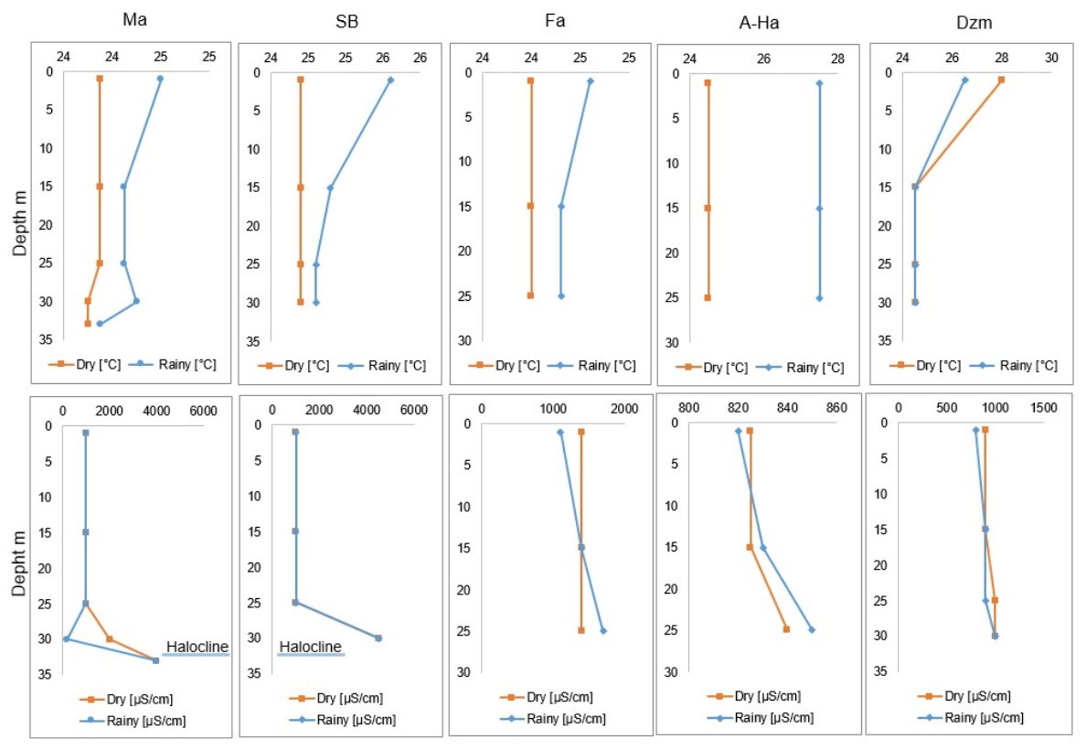
Water physicochemical parameters exhibited a clear spatial pattern along the coastal–inland gradient in the Puerto Morelos region (see Table 2). Sampling sites located closer to the coastline (Ma, SB, and Fa) showed relatively homogeneous temperatures, with mean values around 25 °C. In contrast, inland sites (A-Ha and Dzm) presented higher temperatures up to ~28 °C and greater variability. This pattern likely reflects the thermal buffering effect of marine influence in coastal environments, in contrast to stronger atmospheric control in inland karst systems. The comparatively limited contrast between the two sampling seasons is consistent with the thermal inertia of groundwater and with subsurface water–rock exchange and mixing, which damp short-term atmospheric temperature fluctuations. Accordingly, the spatial coastal–inland contrast was more evident than the seasonal temperature contrast in these two campaigns. Because the study was not designed as a high-frequency thermal time series, this observation should not be interpreted as evidence that seasonal temperature variability is absent.
In addition, pH values across all sites ranged from slightly acidic to slightly alkaline (6.7–8), consistent with carbonate-dominated groundwater typical of the Yucatán Peninsula. Coastal sites exhibited narrower pH ranges, whereas inland sites, particularly at the Dzm cenote, reached pH values up to 8, consistent with carbonate buffering and local hydrogeochemical variability within the karst aquifer system.
ORP values were predominantly positive at all sites, indicating generally oxidizing conditions. Higher and more variable ORP values were recorded at coastal and transitional sites (Ma and Fa), whereas lower values were observed at the inland site Dzm. ORP is a bulk operational indicator of redox conditions (is not a substitute for dissolved-oxygen profiles), and variations in redox potential can influence metal speciation, solubility, sorption, complexation and precipitation. Accordingly, the lower ORP values observed inland may reflect lower oxygen availability and local redox variability, potentially associated with organic matter degradation, microbial activity, and/or reduced hydrodynamic exchange within specific zones of the karst system. In open and semi-open karst systems, oxygenated meteoric recharge and advective exchange through fractures and conduits can transmit relatively oxidizing water to depth, while local reducing zones may coexist where organic-matter degradation and microbial respiration consume available oxidants. Because dissolved oxygen was not profiled independently in this study, the specific source and vertical distribution of oxygen cannot be quantified from ORP alone.
Electrical conductivity (EC) and total dissolved solids (TDS) showed a pronounced decrease with increasing distance from the coastline. Coastal sites exhibited the highest EC values (>1200 µS/cm) and TDS concentrations (~0.6 ppt), reflecting a greater ionic load likely driven by marine intrusion or seawater mixing. In contrast, inland sites displayed substantially lower EC (<1000 µS/cm) and TDS (~0.4 ppt), indicating a dominance of freshwater conditions. The wide EC range observed at the transitional site Fa suggests spatial or temporal variability in mixing between marine and meteoric waters.
Overall, the observed physicochemical gradients highlight the strong influence of coastal proximity on groundwater and water chemistry in the Puerto Morelos karst system, with marine inputs dominating nearshore environments and progressively diminishing inland. These patterns are consistent with previously described hydrogeochemical dynamics in coastal karst aquifers of the Caribbean region [2].
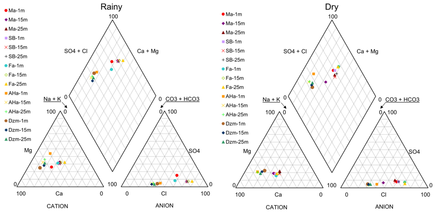
The hydrochemical composition of the five cenotes shows a clear spatial differentiation associated with their relative distance from the coast. Based on the Piper diagram, cenotes Ma, SB, and Fa are characterized by a calcium-sulfate water type (Ca-SO4). In contrast, cenotes A-Ha and Dzm exhibit a calcium-bicarbonate type (Ca-HCO3), as can be seen in Figure 2. The former group corresponds to cenotes located closer to the coastline (Ma and SB) and at an intermediate distance from the coast (Fa), whereas A-Ha and Dzm are situated farther inland. In all cases, the type of water remains stable despite the season. Cenotes Ma and SB are geographically close to each other; in both cases, a halocline was identified at approximately 30 m depth, at which electrical conductivity values of ~4860 and ~4600 µS/cm were measured, respectively (see Figure 3). In contrast, no halocline was detected in cenote Fa until the depth of investigation, despite its intermediate position between the coastal cenotes (Ma and SB) and the inland cenotes (A-Ha and Dzm). Similarly, no halocline was observed in cenotes A-Ha and Dzm.
Based on the hydrochemical facies and physicochemical profiles measured across both climatic seasons, cenotes A-Ha and Dzm can be classified as exclusively freshwater systems. In contrast, cenotes Ma, SB, and Fa exhibit freshwater with marine influence, indicating variable degrees of salinity consistent with their proximity to the coast, as confirmed by analysis of in situ physicochemical parameters.
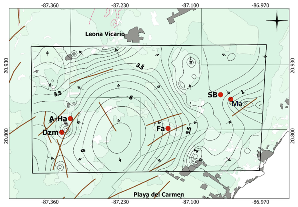
These findings are consistent with the results of a groundwater flow model for the study area, which identifies a recharge zone between Cenote Fa and the inland cenotes, thereby forming a groundwater divide [31], as can be seen in Figure 4. As a result, groundwater flow at cenotes Fa, SB, and Ma is predominantly directed toward or parallel to the coast. In contrast, in the area between Cenote Fa and the inland cenotes, where the groundwater divide lies, flow is directed from A-Ha toward Dzm.
Although the regional groundwater-flow model provides information on the predominant flow directions, it does not provide site-specific groundwater residence times. Independent isotopic evidence from the same regional karst aquifer, however, supports rapid recharge and short residence times. At Yumkin, a deep cenote located approximately 9 km southwest of Leona Vicario, Cejudo et al. [32] reported low tritium activities throughout most of the water column (<~0.8 TU), which were interpreted as evidence of young groundwater, rapid meteoric recharge, and short residence time. The influence of recent rainfall was also reflected by dilution in the shallow water. Nevertheless, the same cenote exhibited pronounced vertical hydrochemical and redox stratification, with a freshwater lens in the upper ~40 m, an intermediate mixing zone at approximately 40–50 m depth, and deeper saline groundwater below ~50 m.
These regional observations provide useful context for the rapid recharge dynamics of the northeastern Yucatán karst aquifer but do not provide site-specific residence times for the cenotes investigated here. Because no artificial tracer tests, environmental-age tracers, or site-specific continuous flow measurements were conducted in the present study, specific groundwater residence times cannot be assigned to Ma, SB, Fa, A-Ha, or Dzm.

4.2. Occurrence of Metals in the Water Column and Sediments

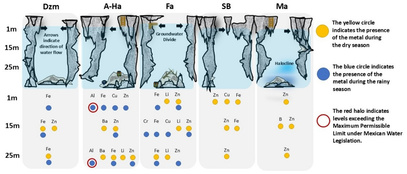
Eight metals were detected in the water column along the Ruta de los Cenotes: Al, Ba, B, Cu, Cr, Fe, Li, and Zn, as can be seen in Figure 5; see Appendix B. In the coastal cenotes Ma and SB, characterized by a calcium-sulfate water type, trace elements were detected exclusively during the dry-season sampling campaign, with concentrations during the rainy season remaining below the detection limits of the analytical technique employed. In SB, Zn was detected at all sampled depths, indicating a vertical distribution during low-recharge conditions, whereas Cu and Fe were detected only at the shallowest depths. In Ma, Zn was detected at all sampled depths, whereas B was detected only at the intermediate depth.
In the inland cenotes A-Ha and Dzm, characterized by calcium-bicarbonate water, trace elements were detected in both climatic seasons, although with marked differences in composition and vertical distribution. In Dzm, Fe was the dominant detected element, occurring at all sampled depths during the rainy-season sampling campaign and at the intermediate and deepest depths during the dry season. Zn was detected only at the intermediate depth during the dry season. In A-Ha, a broader suite of trace elements was observed, including Al, Fe, Cu, Zn, Ba, and Li, with detections extending across multiple depths in both seasons. Notably, Al exceeded the maximum permissible limit for drinking water established by NOM-127-SSA1-2021 [23] (0.2 mg/L), reaching 0.487 mg/L at 1 m and 0.253 mg/L at 25 m during the rainy-season campaign. Fe levels (cenotes Fa and Dzm) also surpassed the permissible limit of 0.3 mg/L specified by the same regulation.
Although the Fa cenote exhibits a calcium-sulfate hydrochemical facies similar to those of the coastal cenotes, its trace element occurrence was more comparable to that observed in inland cenotes, particularly because metals were detected during both sampling campaigns. During the dry season, Li was detected at all sampled depths, Zn was detected at the shallow and intermediate depths, and Fe was detected only at the deepest sampled depth. During the rainy season, Fe and Zn were detected throughout the sampled water column. In contrast, Cr and Cu were detected only at intermediate depths, indicating a broader trace-element occurrence than during the dry-season sampling campaign. The detected trace metals and groundwater flow directions, derived from the groundwater flow model [31] along a land-to-sea transect from Dzm to Ma, are shown in Figure 5.
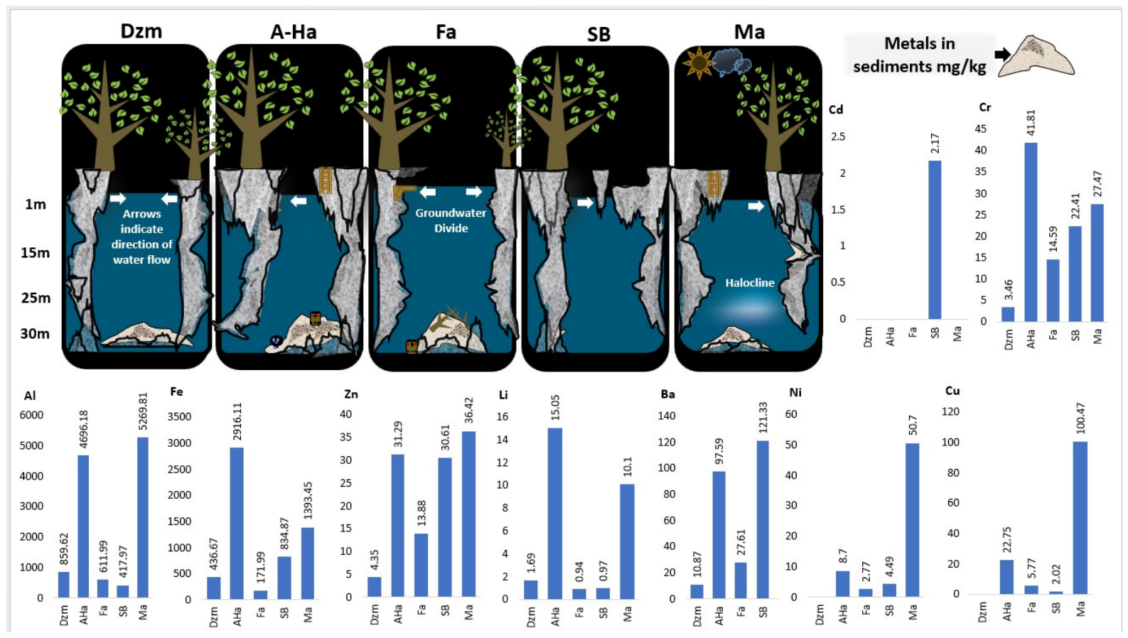
Nine metals were identified in the sediment samples, including Al, Ba, Cd, Cr, Cu, Fe, Li, Ni, and Zn. However, their occurrence and concentrations varied markedly among cenotes (see Figure 6). SB exhibited the highest metal diversity, with all nine elements detected, and was the only site where Cd was present (2.17 mg/kg). In contrast, cenotes Ma, Fa, and A-Ha each contained eight metals, with Cd consistently below detection limits, whereas Dzm showed the lowest metal diversity, with only six detected elements.
Al and Fe were detected in sediments from all five cenotes and had the highest absolute concentrations among the elements analyzed. Al concentrations were highest in Ma (5269.81 mg/kg) and A-Ha (4696.18 mg/kg), reaching values up to eight times higher than those measured in SB, Fa, and Dzm (417.97, 611.99, and 859.62 mg/kg, respectively). A similar pattern was observed for Fe, with maximum concentrations detected in A-Ha (2916.10 mg/kg) and Ma (1393.45 mg/kg) compared with substantially lower values in Fa, Dzm, and SB (171.99, 436.67, and 834.87 mg/kg, respectively).
Overall, sediment metal concentrations did not follow a uniform inland-to-coastal gradient but instead exhibited element-specific and site-dependent patterns. A-Ha showed the highest concentrations of Fe (2916.11 mg/kg), Cr (41.81 mg/kg), and Li (15.05 mg/kg), whereas Ma exhibited the highest concentrations of Al (5269.81 mg/kg), Cu (100.47 mg/kg), Ni (50.70 mg/kg), and Zn (36.42 mg/kg). SB showed the highest Ba concentration (121.33 mg/kg) and was the only site where Cd was detected (2.17 mg/kg). Dzm generally displayed the lowest concentrations for most metals. These contrasting patterns indicate heterogeneous accumulation of sediment metals among cenotes rather than a simple coastal–inland trend.

4.3. Multivariate Characterization of Hydrochemical Data

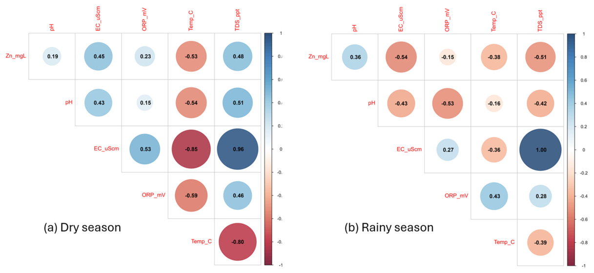
The correlation analysis revealed clear seasonal differences in the relationships between physicochemical parameters and metal concentrations (Figure 7). During the dry season, EC and TDS were strongly and positively correlated, with an r value of 0.96. This indicates that electrical conductivity was mainly influenced by dissolved solids. Both EC and TDS had negative correlations with temperature (EC vs. temperature, r = −0.85; TDS vs. temperature, r = −0.80). This suggests a difference between more mineralized waters and warmer inland waters. Zn showed moderate positive correlations with EC (r = 0.45) and TDS (r = 0.48), and a negative correlation with temperature (r = −0.53). This indicates that the presence of dissolved Zn during the dry season might be associated with the mineralization gradient.
In the rainy season, the correlation structure changed. EC and TDS continued to be strongly correlated (r = 1.00), but Zn showed negative correlations with both EC (r = −0.54) and TDS (r = −0.51). Additionally, pH was negatively correlated with EC (r = −0.43), ORP (r = −0.53), and TDS (r = −0.42). These patterns show that seasonal recharge altered the relationships among metals, mineralization, pH, and redox conditions.
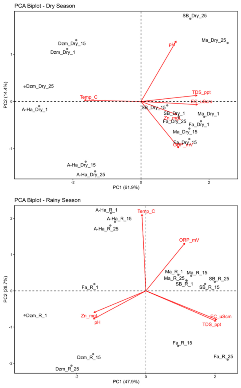
The PCA results showed clear differences in hydrogeochemical gradients between seasons (Figure 8). In the dry season, PC1 explained 61.9% of the total variance, while PC2 explained 14.4%. Together, they accounted for 76.3% of the dataset variability. Temperature, EC, and TDS made the greatest contribution to the variance in PC1. All variables show positive values on this principal component, except for temperature. This component separated the coastal and transitional cenotes Ma, SB, and Fa, which were on the positive side of PC1, from the inland cenotes A-Ha and Dzm, which were on the negative side. Thus, PC1 represents a main mineralization gradient consistent with the coastal–inland hydrogeochemical differentiation shown in the Piper diagram and physicochemical profiles.
During the rainy season, PC1 explained 47.9% of the total variance, while PC2 explained 28.7%. Together, they accounted for 76.6% of the dataset variability. EC and TDS remained strongly correlated and made the greatest contribution to the variance in PC1. Temperature and ORP contributed mainly to PC2. While EC, TDS, and ORP show positive values for this principal component, Zn and temperature show negative values. Compared to the dry season, the sample distribution during the rainy season was more heterogeneous, indicating that recharge processes altered the hydrogeochemical structure of the water column. Ma and SB stayed grouped in the positive direction of PC1, while A-Ha, Dzm, and Fa showed more site- and depth-specific distributions.
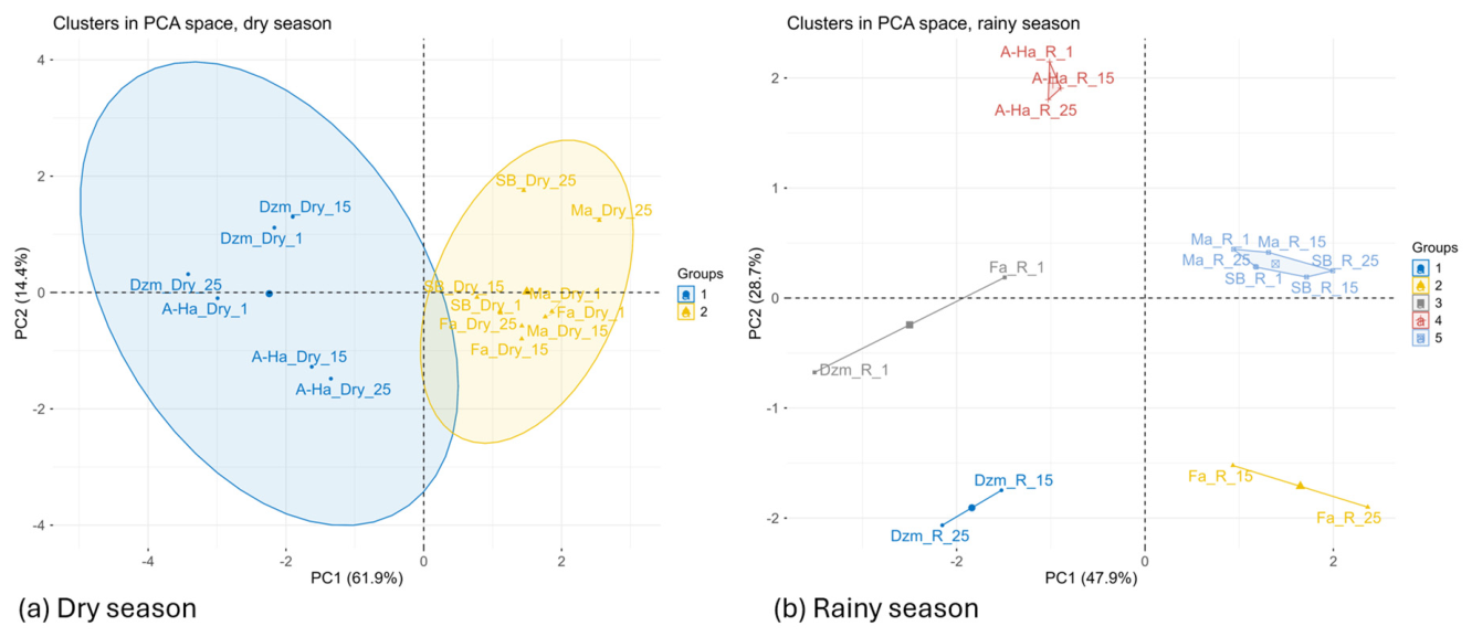
Cluster analysis in the PCA space further supported the seasonal contrast in hydrogeochemical organization (Figure 9). During the dry season, k-means clustering identified two main groups. The first cluster included the inland cenotes A-Ha and Dzm. The second cluster grouped Ma, SB, and Fa. This separation closely followed PC1 and reflected the dominant coastal–inland mineralization gradient.
In contrast, during the rainy season, five clusters were identified, indicating greater hydrogeochemical variation. Ma and SB formed a common group, consistent with their higher mineralization, coastal influence, and close proximity. A-Ha samples formed an independent cluster, suggesting a coherent site-specific hydrogeochemical signature. Dzm samples were separated into shallow and deeper groupings, while Fa showed a depth-dependent structure, with deeper samples forming a distinct cluster. These results indicate that, during the rainy season, recharge and local vertical variability had a stronger influence on sample grouping than in the dry season.

4.4. Ecological Risk Assessments in Groundwater

The ecological risk assessment for metals in the water column followed the method suggested by Karlsson [25]. It used predicted no-effect concentrations from toxicological data for zooplankton species. A total of 34 LC50 values were compiled for Al (n = 2), Cr (n = 7), Cu (n = 9), Fe (n = 1), Li (n = 3), Zn (n = 8), B (n = 2), and Ba (n = 2), where n denotes the number of LC50 values for each element; see Table A1 in Appendix A. These values came from representative taxa including rotifers, cladocerans, and ostracods. For each metal, the lowest LC50 values were divided by a conservative risk factor to estimate PNEC values, as described in Equation (1). This calculation considered toxicological uncertainty and the limited data available for native karst species.
Table 3 summarizes the resulting PNEC values. These PNEC values reflect a cautious approach and aim to protect highly sensitive aquatic organisms. Ecological risk categories were assigned based on the ratio between measured metal concentrations in the water column (MEC) and the related PNEC values (Equation (2)).
Clear seasonal, spatial, and depth-related patterns were observed in the ecological risk values (RA). During the dry-season sampling campaign (Table 4), ecological risk ranged from low to high, with high RA values mainly associated with Li, Cu and Zn at specific depths in Fa, A-Ha, SB and Ma. Moderate RA values were also associated with B, Ba, Fe and Zn in selected samples. During the rainy-season sampling campaign (Table 5), higher and more widespread RA values were observed in the inland cenote A-Ha and in the transitional cenote Fa. In Dzm, low values associated with Fe were observed at greater depths. In A-Ha, higher RA values were associated with Al.
Among the elements analyzed, Al, Fe, Li, Cu and Zn were the primary contributors to high ecological risk in groundwater. Cu and Zn reached high RA values in several cenotes and depths during both sampling campaigns, whereas Li reached high RA values only during the dry-season campaign and Fe only during the rainy-season campaign. Al produced the highest RA, specifically in A-Ha during the rainy-season sampling campaign at 1 and 25 m depth. In addition, B, Ba, Fe, and Zn contributed low to moderate ecological risk in specific samples, whereas Cr remained within the moderate-risk category in cenote Fa. It is important to emphasize that this screening-level ecological risk assessment is a conservative framework designed to identify potential vulnerability rather than confirm ecological impairment. The estimated ecological risk reflects the sensitivity of zooplankton species to metals under precautionary assumptions and does not imply actual population decline or ecological damage.
To provide a direct season-level comparison of ecological vulnerability, the detected elements were ranked using the maximum screening-level risk quotient (RA) observed at any sampled depth within each season. For the dry-season campaign, the ranking was Li (maximum RA = 100) > Cu (50.00) > Zn (20.00) > Fe (6.98) > B (4.08) > Ba (2.46); Al and Cr were not detected in the dry-season risk dataset. For the rainy-season campaign, the ranking was Al (3043.75) > Fe (74.15) > Zn (66.25) > Cu (20.00) > Cr (2.77); B, Ba, and Li were not detected in the rainy-season risk dataset. This ordering is a conservative ranking of observed screening risk under the sampled conditions and should not be interpreted as a ranking of intrinsic metal toxicity, source strength, or long-term exposure.

4.5. Enrichment Factor, Geoaccumulation Index, and Potential Ecological Risk in Sediments

The EF, Igeo, and RI were calculated for Cr, Cd, Cu, Ni, and Zn in sediment samples (Table 6). Blank cells indicate that the corresponding metal was not detected; therefore, EF and Igeo values were not calculated for those cases. Overall, the results showed marked differences among metals and cenotes, indicating that sediment-associated metal enrichment and geoaccumulation were element-specific and did not follow a simple linear relationship with distance to the coast.
According to the EF values, the highest enrichment categories were observed mainly in the coastal and transitional cenotes. SB, located approximately 17 km from the coast, was the only cenote in which Cd was detected, exhibiting extremely high Cd enrichment. Ma, the closest cenote to the coast (~16 km), showed extremely high Cu enrichment and significant enrichment for Cr and Ni, whereas Zn showed moderate enrichment. Fa, located at an intermediate distance from the coast (~26 km), showed very high enrichment for Cr and Cu, significant enrichment for Zn, and moderate enrichment for Ni. In contrast, the inland cenotes showed lower or more restricted enrichment patterns. A-Ha, the farthest inland cenote (~48 km), showed significant Cu enrichment and moderate enrichment for Cr and Zn, while Ni showed minimal enrichment. Dzm, located 46 km from the coast, showed detectable enrichment only for Cr and Zn, with moderate Cr enrichment and minimal Zn enrichment; Cd, Cu, and Ni were not detected at this site.
The Igeo values showed a more restricted geoaccumulation pattern than the EF values. Cd in SB showed the highest Igeo value, corresponding to extremely high pollution. Cu showed the strongest geoaccumulation signal in Ma, reaching strong to extremely strong pollution, whereas moderate pollution was observed in A-Ha. Cr showed moderate pollution in A-Ha, unpolluted to moderately polluted conditions in SB and Ma, and unpolluted conditions in Dzm and Fa. Zn showed limited geoaccumulation, ranging from unpolluted to unpolluted-moderately polluted conditions across the cenotes where it was detected. Ni showed unpolluted conditions in A-Ha, Fa, and SB, and unpolluted to moderately polluted conditions in Ma. Therefore, although EF values indicated enrichment for several metals, Igeo values suggest that the most relevant geoaccumulation signals were associated mainly with Cd in the SB cenote and Cu in the Ma cenote.
The potential ecological risk index (RI) also showed strong spatial differences among cenotes; see Appendix C. SB exhibited an extremely high potential ecological risk (RI = 1868.66), primarily due to Cd in sediments. Ma showed a low potential ecological risk (RI = 145.08), although its value was close to the moderate-risk threshold. A-Ha (RI = 39.78), Fa (RI = 11.25), and Dzm (RI = 0.85) were classified as low-risk environments. These results indicate that sediment-associated ecological risk was highly localized, with the highest risk concentrated in SB rather than showing a gradual increase or decrease along the coastal–inland transect.
Notably, Cd was detected exclusively in sediments from SB and was not detected in the water column during the sampling campaigns, despite having been reported in groundwater in previous investigations of the region. The absence of detectable Cd in groundwater may be related to concentrations remaining below the analytical detection limits or within permissible ranges for the techniques employed. This contrast indicates that sediment analysis provides complementary information to water-column measurements and may reveal metal accumulation patterns that are not evident from dissolved concentrations alone. Therefore, the combined evaluation of EF, Igeo, and RI provides a more complete assessment of sediment metal enrichment, geoaccumulation, and potential ecological risk along the Ruta de los Cenotes.
Importantly, the results presented here establish a robust and precautionary baseline for future ecological evaluations, enabling the detection of subtle changes in metal-related risk and supporting long-term assessments of environmental vulnerability under evolving hydrogeochemical and anthropogenic pressures. This baseline is particularly valuable, as it is derived from data collected prior to the construction of the Maya Train Station in Puerto Morelos.

5. Discussion

5.1. Controls on Metal Occurrence in Groundwater

In karst aquifer systems, groundwater quality is strongly controlled by hydrogeological heterogeneity, groundwater mixing, vertical stratification, and redox-driven processes that regulate solute transport and attenuation. In cenote systems, the high hydraulic connectivity between surface and subsurface environments can promote rapid contaminant transport; in contrast, local stratification and redox gradients may control the mobility, speciation, and persistence of trace metals in the water column. These hydrogeochemical controls provide a useful framework for interpreting the spatial, vertical, and seasonal patterns of metal occurrence observed along the Ruta de los Cenotes.
The detected elements may originate from both geogenic and anthropogenic sources, and the present dataset does not support unique source apportionment. Potential geogenic contributions include interaction with carbonate-associated materials, minor silicate or oxide phases, terrigenous particles stored in soils and epikarst, and mixing processes along the freshwater–saline groundwater transition. Potential anthropogenic contributions include diffuse inputs associated with septic and wastewater systems, tourism and traffic, infrastructure and construction materials, and residual or informal waste disposal. In the Yucatán karst aquifer, these constituents can enter the saturated zone rapidly during rainfall recharge because thin soils, fractures, solution openings, and conduits provide short pathways from the surface and epikarst to groundwater. Once in the aquifer, advective conduit flow, matrix–fracture exchange, seasonal dilution, marine mixing, and redox-controlled sorption or precipitation can redistribute elements vertically and laterally. Accordingly, detections at 15–25 m depth do not necessarily imply a deep geogenic source; they may also reflect preferential recharge and rapid transport through hydraulically connected karst pathways. These potential source and transport mechanisms must therefore be interpreted within the broader hydrogeochemical framework of the aquifer, particularly the coastal–inland mineralization gradient and its seasonal modification.
Within this hydrogeological framework, the hydrochemical facies provide an independent indication of the spatial processes governing groundwater composition along the coastal–inland transect. Calcium-sulfate waters characterized Ma, SB, and Fa, whereas A-Ha and Dzm showed calcium-bicarbonate waters. This distribution consists of a stronger influence of saline groundwater mixing and marine-derived solutes in the coastal and transitional cenotes, while the inland cenotes are dominated by meteoric freshwater recharge and carbonate–water interaction. Although these facies do not identify the sources of individual metals, they define the hydrogeochemical conditions under which metal transport, dilution, and partitioning occur. The exploratory multivariate analysis was consistent with this spatial pattern: during the dry-season campaign, the PCA differentiated Ma, SB, and Fa from A-Ha and Dzm along a dominant mineralization gradient associated mainly with EC and TDS. During the rainy-season campaign, the PCA and clustering showed greater site- and depth-specific variability, suggesting that recharge and local vertical heterogeneity became comparatively more important in structuring groundwater chemistry under higher-recharge conditions.
In the coastal cenotes Ma and SB, metals were detected only during the dry-season sampling campaign. This pattern is consistent with reduced dilution under low-recharge conditions, when dissolved constituents may become more detectable in the water column [7]. In SB, Zn was present throughout the sampled water column, whereas Cu and Fe were restricted to shallow depths. In the Ma cenote, Zn was detected at all sampled depths, whereas B was detected only at intermediate depth. These patterns suggest limited but vertically differentiated trace element occurrence under dry-season conditions, rather than a generalized contamination signal throughout the water column. Under these conditions, reduced dilution and limited water renewal may enhance the persistence of trace metals originating from potential diffuse sources, including tourism-related activities, septic systems, and residual contamination from historical waste disposal practices. Similar seasonal contrasts in metal concentrations have been reported in other regions of the Yucatán Peninsula aquifer system, where dry-season conditions can amplify the detectability of contaminants [33].
In Ma, the observed metal distribution patterns are further influenced by pronounced vertical stratification associated with the H2S layer at approximately 26 m depth. This sulfidic interface represents a sharp redox boundary that can exert strong control on metal speciation, mobility, and partitioning between dissolved and particulate phases. Under reducing conditions, metals such as Fe, Cu, and Zn may undergo sulfide complexation or precipitation, favoring their retention near or below the redoxcline and limiting upward diffusion into the oxic water column. Conversely, episodic disturbances related to recharge events, internal mixing, or density-driven flow may promote partial remobilization of metal species across this interface. The coexistence of elevated sedimentary metal accumulation and low dissolved concentrations in Ma is therefore consistent with a system in which redox-controlled sequestration processes operate alongside restricted vertical mixing, highlighting the importance of stratification in governing metal behavior in deep, semi-open karst systems.
In contrast, the inland cenotes A-Ha and Dzm showed metal occurrence during both sampling campaigns. In Dzm, Fe was the most frequently detected element and showed a broader vertical distribution than Zn, particularly during the rainy-season sampling campaign. In A-Ha, a wider suite of dissolved elements was detected, including Al, Fe, Cu, Zn, Ba, and Li. The exceedance of the Mexican drinking-water limit established by NOM-127-SSA1-2021 for Al at depths of 1 and 25 m during the rainy-season sampling campaign suggests that recharge-related mobilization from soils, epikarst materials, or local surface inputs may locally increase dissolved Al concentrations in the aquifer. This interpretation is consistent with Bautista [34], who reported the presence of multiple elements under high-recharge conditions. In addition, previous studies have identified population growth, tourism, and inadequate wastewater management as major drivers of metal inputs to cenotes in this region [7,35]. However, because Al exceeded drinking-water standards, these results should be interpreted as localized exceedances rather than widespread deterioration of groundwater quality.
The Fa cenote represents a transitional case. Although its calcium-sulfate facies is similar to that of the coastal cenotes, its trace element occurrence was more comparable to inland cenotes because metals were detected during both sampling campaigns. The broader occurrence of Fe and Zn during the rainy season, together with the detection of Cr and Cu at intermediate depth, suggests that recharge, local mixing, and vertical heterogeneity influence metal distribution in this cenote. This behavior is consistent with its intermediate hydrogeological position near the groundwater divide, where marine influence and continental recharge processes may interact.
Overall, metal concentrations in the water column appear to be controlled by the interaction among coastal–inland mineralization, seasonal recharge, local redox variability, and site-specific hydrodynamic conditions. The fact that most metals remain below drinking-water limits does not necessarily imply absence of ecological concern, particularly in groundwater-dependent ecosystems, where sensitive aquatic organisms may respond to concentrations below human-health-based regulatory thresholds.
In this context, the detection of Li deserves attention. While Li concentration remained low and did not exceed the guideline values considered in this study, its occurrence only during the dry-season sampling campaign suggests that dilution processes and seasonal recharge dynamics may influence detectability within the cenote system. However, with the current dataset, Li should be interpreted as a hydrogeochemical observation rather than evidence of a specific source.
Overall, the persistence of hydrochemical facies across seasons suggests that the major-ion composition of the cenotes is relatively buffered. However, the seasonal differences observed in the occurrence of dissolved trace elements indicate that metal detectability is sensitive to recharge, dilution, and local hydrogeochemical conditions. Together, these findings highlight the vulnerability of karst aquifers to both natural and anthropogenic controls, as their high permeability and limited attenuation capacity facilitate the rapid transport of dissolved constituents, allowing even diffuse sources to influence groundwater quality over relatively short timescales [36].

5.2. Metal Accumulation in Sediments

Sediment analyses provide complementary information to water-column measurements because sediments can integrate metal accumulation over longer timescales and may retain metals that are not detected in dissolved form during discrete sampling campaigns. Along the Ruta de los Cenotes, nine metals were detected in sediments, with clear site-dependent variability in both occurrence and concentration. This variability indicates that sediment-bound metals do not follow a simple coastal–inland pattern but rather reflect element-specific accumulation controlled by local hydrogeochemical, sedimentary, and hydrodynamic conditions.
The concentration patterns observed in sediments showed marked differences across elements and cenotes. Al and Fe had the highest absolute concentrations among the elements analyzed, reflecting their natural abundance in carbonate-associated materials and terrigenous inputs. However, their spatial distribution varied between cenotes. Al concentrations were highest in Ma and A-ha, whereas Fe reached its highest concentration in A-Ha. Other elements also showed site-specific patterns: Ba reached its highest concentration in SB, Cr and Li were highest in A-Ha, Cu and Ni showed their highest concentrations in Ma, and Zn showed relatively high concentrations in A-Ha and SB. Cd was detected exclusively in SB. These results indicate that sediment composition is heterogeneous among cenotes and cannot be explained solely by distance from the coast.
Although Al is one of the most abundant elements in the Earth’s crust (Lizano et al., [37]), its high concentrations in sediments, together with its exceedance of drinking-water limits in groundwater at specific sites, suggest that natural background levels may be locally modified by mobilization from soils, infrastructure materials, or waste-related sources [38,39].
The presence of trace metals such as Cr, Cu, Ni, Zn, Li, and Cd is of relevance because these elements may reflect contributions from minor non-carbonate mineral phases, sedimentary inputs, or localized external sources, since they are not typically associated with the carbonate-dominated lithology of the Yucatán Peninsula. Their detection in sediments indicates accumulation within cenote systems; also, source-specific attribution requires additional tracers. The exclusive detection of Cd in sediments from the SB cenote is especially noteworthy, given its high toxicity and its absence in the water column. This pattern suggests that Cd may currently be retained in sediments under prevailing physicochemical conditions, acting as a latent source that could be remobilized if redox conditions or hydrodynamic regimes change [39]. Therefore, sediments should not be interpreted only as passive repositories, but as environmental compartments that may influence long-term metal availability under changing hydrogeochemical conditions.
It is important to distinguish between absolute metal concentrations, enrichment, geoaccumulation, and ecological risk indices. Although Al and Fe showed high absolute concentrations in sediments, they were not included in the calculation of the enrichment factor, geoaccumulation index, and potential ecological risk index because the information required to calculate these indices was not available for these elementes. Therefore, these indices were calculated for Cr, Cd, Cu, Ni, and Zn. In addition, Fe was used as the reference element for EF calculations. Therefore, high absolute concentrations of Al and Fe should not be directly interpreted as equivalent to high enrichment or ecological risk under the EF, Igeo, and RI frameworks.
In particular, the EF patterns indicate that enrichment was more pronounced in specific coastal and transitional cenotes, particularly Fa, SB, and Ma, but without forming a simple linear coastal–inland trend. The Igeo values showed a more restricted geoaccumulation pattern than the EF values. Cd in SB showed the strongest geoaccumulation signal, reaching the extremely polluted category. Cu showed the strongest geoaccumulation signal in Ma, falling into the strong-to-extremely strong pollution category, whereas A-Ha showed moderate Cu pollution. Cr showed moderate pollution in A-Ha, unpolluted to moderately polluted conditions in SB and Ma, and unpolluted conditions in Dzm and Fa. Zn showed only limited geoaccumulation, ranging from unpolluted to unpolluted–moderately polluted conditions across the cenotes where it was detected. Ni remained within unpolluted conditions in A-Ha, Fa, and SB, and unpolluted to moderately polluted conditions in Ma. Therefore, the most relevant geoaccumulation signals were associated mainly with Cd in SB and Cu in Ma.
The potential ecological risk index indicated that the ecological risk associated with sediments was highly localized. SB exhibited an extremely high potential ecological risk, mainly driven by Cd in sediments. In contrast, Ma showed low potential ecological risk, although its value was close to the moderate-risk threshold, whereas A-Ha, Fa, and Dzm were classified as low-risk environments. Therefore, the sediment risk pattern does not indicate a gradual increase or decrease with distance from the coast. Instead, it identifies SB as a localized sediment-risk hotspot controlled primarily by Cd.
Overall, the combined evaluation of sediment concentrations, EF, Igeo, and RI, indicate that sediments are essential for assessing metal-related vulnerability in cenote ecosystems. While water-column concentrations provide information on the metals currently present in the aquatic phase, sediment concentrations provide evidence of localized metal accumulation and potential long-term risk. This is particularly important for SB, where Cd produced an extremely high sediment-associated ecological risk despite not being detected in groundwater during the sampling campaigns. These findings support the need to include sediment monitoring, repeated seasonal sampling, and studies of sediment–water interactions in future ecological risk assessments of cenote systems.

5.3. Ecological Relevance and Screening-Level Risk to Zooplankton

The ecological risk assessment conducted in this study represents a screening-level evaluation of potential metal-related risks to zooplankton communities in cenotes along the Ruta de los Cenotes. By integrating measured environmental metal concentrations with PNEC values derived from published toxicity data, this approach provides an early-warning perspective on ecosystem vulnerability rather than evidence of current ecological impairment.
Among the metals detected in groundwater, Al, Fe, Li, Cu and Zn were the main contributors to high screening-level ecological risk. Although Al exceeded the drinking-water limit established by Mexican regulations, comparisons with toxicity thresholds reported for sensitive zooplankton species indicate that concentrations below regulatory standards may still be ecologically relevant. Al concentrations measured in the A-Ha cenote during the rainy-season sampling campaign exceeded LC50 values reported for the rotifer Lecane quadridentata [40], suggesting that localized exposure could pose a potential risk to sensitive zooplankton taxa under sustained conditions. These comparisons are intended to provide ecological context and should be interpreted as indicative rather than confirmatory, given the absence of site-specific toxicity testing.
Seasonal variability in ecological risk was observed, with higher and more widespread risk values generally associated with the rainy-season sampling campaign in inland and transitional cenotes. This pattern may reflect recharge-related metal mobilization and increased exposure of planktonic organisms to dissolved contaminants. However, high ecological risk values also occurred during the dry-season sampling campaign at specific depths, mainly associated with Li, Cu, and Zn. Previous studies in the region have documented metal bioaccumulation in zooplankton, particularly for Zn, Fe, and Cu, with higher bioaccumulation factors reported during the dry season [30]. Together, these findings support the use of zooplankton as sensitive indicators of temporal changes in water quality in karst systems [41].
In this study, ecological risk to zooplankton communities was assessed by combining groundwater chemistry with toxicity data compiled from scientific literature, including data on rotifers, cladocerans, ostracods, and other aquatic invertebrates. Reported LC50 values for taxa such as Lecane quadridentata, Cypridopsis vidua, and Daphnia magna indicate a wide range of sensitivity to metals such as Al, Fe, Cr, Cu, and Zn [40,42]. This variability highlights the uncertainty associated with extrapolating toxicity thresholds across species and reinforces the conservative nature of the present screening-level assessment.
The detection of metals in both the water column and sediments highlights the potential for coupled exposure pathways in cenote ecosystems. Sediment-associated metals may be ingested by zooplankton or remobilized into the water column as redox or hydrodynamic conditions change, thereby increasing their potential bioavailability [43]. Recent bioaccumulation studies conducted at the same sites confirmed that metals detected in the environment are bioavailable to zooplankton communities [30].
Furthermore, Cd is of environmental concern along the Ruta de los Cenotes because it was detected exclusively in sediments from SB and was responsible for the extremely high sediment-associated ecological risk at this site. Although Cd was not detected in the water column during the present sampling campaigns, previous reports from the Ruta de los Cenotes corridor documented Cd concentrations in groundwater ranging from 0.007 to 0.022 mg/L [9]. In addition, other studies have reported Cd bioaccumulation in zooplankton collected during the dry season from cenotes within the same route. These findings suggest that Cd occurrence may be localized, intermittent, or preferentially associated with sedimentary compartments. Therefore, SB should be considered a priority site for follow-up monitoring, including repeated sediment sampling, porewater analysis, and bioaccumulation studies.
Cd bioaccumulation in apparently viable zooplankton communities suggests that this metal may occur under sublethal exposure conditions, potentially contributing to its redistribution among water, sediments, and biota through biological and ecological processes, in addition to hydrogeological dynamics and seasonal hydrogeochemical changes. Together, these processes reinforce the role of cenotes as dynamic interfaces where contaminants can circulate among water, sediments, and aquatic biota over time.
Overall, metal contamination in the Quintana Roo aquifer, particularly along the Ruta de los Cenotes, appears to occur as localized hotspots rather than a widespread critical threat in the short term. However, the recurrent detection of potentially toxic elements such as Cd, Cr, Cu, Al, Hg, and others in groundwater, sediments, and zooplankton, as reported in this and previous regional studies, indicates that metal exposure pathways are active within cenote ecosystems [8]. Although contamination sources may be diverse, increasing socioeconomic and tourism-related activities can contribute to the deterioration in water quality and ecological integrity if adequate monitoring and management strategies are not implemented.
Given the high vulnerability and permeability of the karst aquifer system, environmental monitoring should be continuous and strategically designed to identify contamination trends, evaluate ecological risks, and mitigate future adverse effects on aquatic biota, ecosystem health, and human populations that depend directly or indirectly on these groundwater resources. This is particularly relevant because zooplankton is a key component of aquatic food webs, and metal bioaccumulation at this level may indirectly affect higher trophic levels via trophic transfer, potentially affecting ecosystem functioning in cenote systems. Although no direct biological measurements were conducted in this study, integrating hydrogeochemical data with conservative ecological risk metrics underscores the relevance of early-warning assessments for identifying vulnerable cenotes. It emphasizes the need for continued monitoring, toxicity tests, and bioaccumulation analyses to better understand the long-term implications of metal contamination in this vulnerable karst system.


6. Conclusions

This study provides an integrated assessment of metal occurrence in groundwater and sediments from cenotes along the Ruta de los Cenotes, a karst aquifer system increasingly exposed to pressures associated with tourism development, urban expansion, and land-use change in northeastern Quintana Roo, México.
In groundwater, most metals remained below Mexican drinking-water limits. However, Al exceeded the 0.2 mg/L regulatory limit in A-Ha at 1 and 25 m, while Fe surpassed its 0.3 mg/L limit in Dz and Fa at 15 and 25 m during the rainy- and dry-season campaign, indicating localized vulnerability under recharge-influenced conditions. Nine metals were identified in the sediment samples, including Al, Ba, Cd, Cr, Cu, Fe, Li, Ni, and Zn. Al and Fe showed the highest absolute concentrations, whereas trace metals such as Cr, Cu, Ni, Zn, Li, and Cd displayed site-specific accumulation patterns. SB was identified as a sediment-risk hotspot due to the exclusive detection of Cd, resulting in an extremely high potential ecological risk. In contrast, Ma showed low potential ecological risk, although it was close to the moderate-risk threshold, while A-Ha, Fa, and Dzm remained within low-risk categories.
Based on their hydrochemical facies, cenotes A-Ha and Dzm exhibit freshwater conditions throughout the investigated water columns, whereas cenotes Ma, SB, and Fa exhibit freshwater conditions with varying marine influence. The rainy season, recharge, and vertical variability appeared to have a greater influence on sample distribution than the dry season. In the inland cenotes (A-Ha and Dzm), a greater number of metals were detected during the rainy season, while in the coastal cenotes with saline influence (Ma and SB), metals were detected mainly during the dry season. These results suggest that recharge during the rainy season may favor the mobilization of trace elements in freshwater cenotes, while saline influence may contribute to a different distribution pattern.
Seasonal variability in ecological risk was evident, with higher and more widespread risk values generally associated with the rainy-season sampling campaign in inland and transitional cenotes. The ecological risk assessment indicates seasonal and vertical variations in metal toxicity within the Ruta de los Cenotes karst aquifer. During the dry season, moderate risk was concentrated at a depth of 15 m, primarily associated with Ba, B, Zn, and Fe. In contrast, high-risk values were located at the extremes of the water column: at 25 m (due to Li and Zn) and at 1 m (caused by Li, Cu, and Zn, alongside a moderate risk value for Zn). During the rainy season, the risk profile was distributed homogeneously throughout the water column; seven high-risk values were recorded at 1 m, while three high-risk and three moderate-risk values were observed at 15 m and 25 m, respectively—primarily attributed to Al, Cu, Fe, Zn, and Cr. Inland freshwater cenotes exhibited moderate to high risks at all depths during the rainy season, whereas during the dry season, risk was limited to the 15 m and 25 m depths. Conversely, cenotes near the coast displayed a moderate-to-high risk profile throughout the entire water column (1–25 m) in both seasons, with a higher prevalence of high-risk values during the rainy season. These results demonstrate that ecological risk in this karst aquifer is influenced by the interaction between seasonality, depth, and local hydrogeochemistry. Consequently, the implementation of continuous monitoring for metal exposure is suggested.
This pattern may reflect recharge-related metal mobilization and potentially greater exposure of aquatic organisms to contaminants. These findings should be interpreted as early-warning indicators rather than evidence of current ecological impairment, given the absence of site-specific toxicity tests and direct biological measurements in this study.
Overall, the integration of hydrogeochemical characterization, multivariate analysis, sediment analysis, and ecological risk assessment represents a strength of the study, as it provides a baseline for understanding metal occurrence and ecological vulnerability in cenotes. However, the spatial and temporal coverage of the sampling limits the assessments of longer-term changes. Therefore, long-term monitoring should be strengthened by incorporating water, sediment, and biota samples, as well as ecotoxicological studies with native or locally representative species of the region. This approach can improve environmental monitoring and contribute to the protection of cenotes, which are fundamental to regional biodiversity, local communities, and groundwater resources of the Yucatán Peninsula.

Supplementary Materials

The following supporting information can be downloaded at: https://www.mdpi.com/article/10.3390/earth7050151/s1.

Author Contributions

Conceptualization, J.A.P.-B. and J.A.-F.; methodology, G.P.-G., J.A.P.-B. and J.A.-F.; software, G.P.-G., J.A.P.-B. and J.A.-F.; validation, G.P.-G., J.A.P.-B., A.K.C., Y.L., J.H.H.-A., G.d.A.-A., R.M.L.-B., I.A.P.-L. and J.A.-F.; formal analysis, G.P.-G., J.A.P.-B., A.K.C., Y.L., J.H.H.-A., G.d.A.-A., R.M.L.-B., I.A.P.-L. and J.A.-F.; investigation, G.P.-G., J.A.P.-B., A.K.C., Y.L., J.H.H.-A., G.d.A.-A., R.M.L.-B., I.A.P.-L. and J.A.-F.; data curation, G.P.-G., J.A.P.-B. and J.A.-F.; writing—original draft preparation, J.A.P.-B. and J.A.-F.; visualization, G.P.-G., J.A.P.-B. and J.A.-F.; project administration, J.A.P.-B. and J.A.-F. All authors have read and agreed to the published version of the manuscript.

Funding

This research received no external funding.

Data Availability Statement

The raw data supporting the conclusions of this article will be made available by the authors upon request.

Acknowledgments

The authors acknowledge the students Miguel Balam, Luis Ortega, Mey Hing, Mauricio Parra, Aurora Troncoso, Daniela Guerrero, Santiago Romero, Alejandra Benavides, Gibran Jalil, and Alexis González from Universidad del Caribe for their assistance during fieldwork. We also thank the Ejido communities along the Ruta de los Cenotes in Puerto Morelos for site access and logistical support. The authors are grateful to the expert cave divers Nestor Viotto and Ricardo Rubio for their support during underwater exploration, and to Eduardo Cejudo and Daniela Ortega for laboratory analyses. Additional thanks are extended to Pedro Almada, Karla Ortega, Camila Jaber, Juan Bárcenas, and Dino Demidof for their participation in exploration activities. We are grateful to Ana Elisa Morales Grajales for the ostracod illustration. This work was conducted as part of Secihti project No. 6998.

Conflicts of Interest

The authors declare no conflicts of interest.

Appendix A

LC50 values reported in the scientific literature are presented for selected zooplankton and other aquatic invertebrate species. These values were compiled exclusively from published studies and were used in the present work as reference toxicity thresholds to support the screening-level ecological risk assessment. The reported LC50 values do not correspond to experimental determinations conducted in this study but rather provide a comparative framework for evaluating the potential sensitivity of zooplankton communities to dissolved metals detected in the cenotes along the Ruta de los Cenotes. Differences among species, exposure times, and experimental conditions reflect the inherent variability in toxicity responses and reinforce the conservative nature of the risk assessment approach adopted.
Table A1. Recompilation of LC50 values (mg/L) for zooplankton from scientific literature.
MetalZooplankton SpeciesLC50References
ZnAnuraeopsis fissa0.31[40]
ZnBrachionus calyciflorus1.30 [40]
ZnB. calyciflorus1.65 [40]
ZnB. havanaensis2.27 [40]
ZnB. rubens0.55 [40]
ZnLecane quadridentata0.12 [40]
ZnPhilodina acuticornis2.40 [40]
ZnCypridopsis vidua0.08 [44]
FeLecane quadridentata0.53 [40]
CuPhilodina acuticornis0.14 [40]
CuP. acuticornis1.00 [40]
CuLecane quadridentata0.33 [40]
CuL. luna0.06 [40]
CuL. hamata0.23 [40]
CuBrachionus plicatilis0.12 [40]
CuB. patulus0.20 [40]
CuB.calyciflorus0.03 [40]
CuAsplanchna brightwellii0.05 [40]
AlBrachionus calyciflorus3.00 [40]
AlLecane quadridentata0.16 [40]
CrBrachionus calyciflorus8.30 [40]
CrLecane hamata4.41 [40]
CrL. luna3.26 [40]
CrL. quadridentata4.50 [40]
CrCypridopsis vidua0.36 [44]
CrCypridopsis vidua2.68 [42]
CrDiaphanocypris meridiana2.00 [42]
LiEurytemora affinis55.33 [45]
LiEurytemora affinis67.81 [45]
LiDaphnia magna0.04 [46]
BDaphnia magna57.00 [47]
BDaphnia magna115.00 [47]
BaDaphnia magna13.00 [47]
BaDaphnia magna20.00 [47]

Appendix B

In this appendix, the concentrations of metals determined in groundwater and sediments in the study area are presented.
Table A2. Metals detected in groundwater from the Ma cenote during the rainy and dry season.
B (mg/L)Zn (mg/L)
RainyDryRainyDry
1 m<LMD<LMD<LMD0.012
15 m<LMD0.233<LMD0.006
25 m<LMD<LMD<LMD0.008
Table A3. Metals are detected in groundwater from the SB cenote during the rainy and dry season.
Fe (mg/L)Cu (mg/L)Zn (mg/L)
RainyDryRainyDryRainyDry
1 m<LMD0.007<LMD0.015<LMD0.016
15 m<LMD0.004<LMD<LMD<LMD0.004
25 m<LMD<LMD<LMD<LMD<LMD0.008
Table A4. Metals detected in groundwater from the Fa cenote during the rainy and dry season. Cr and Cu were not detected in the dry season, whereas Li was not detected during the rainy season.
Cr (mg/L)Fe (mg/L)Cu (mg/L)Li (mg/L)Zn (mg/L)
RainyRainyDryRainyDryRainyDry
1 m<LMD0.107<LMD<LMD0.0080.0270.004
15 m0.0100.393<LMD0.0050.0070.0530.003
25 m<LMD0.0730.008<LMD0.0060.014<LMD
Table A5. Metals detected in groundwater from the A-Ha cenote during the rainy and dry season. Al and Cu were not detected in the dry season, whereas Ba and Li were not detected during the rainy season.
Al (mg/L)Ba (mg/L)Fe (mg/L)Cu (mg/L)Li (mg/L)Zn (mg/L)
RainyDryRainyDryRainyDryRainyDry
1 m0.487<LMD0.114<LMD0.006<LMD0.045<LMD
15 m<LMD0.025<LMD<LMD<LMD<LMD0.0080.003
25 m0.2530.0320.0480.006<LMD0.006<LMD0.014
Table A6. Metals are detected in groundwater from the Dzm cenote during the rainy and dry season.
Fe (mg/L)Zn (mg/L)
RainyDryRainyDry
1 m0.064<LMD<LMD<LMD
15 m0.0080.037<LMD0.003
25 m0.0060.036<LMD<LMD
Table A7. Metal concentrations found in sediments at 30 m depth, in all cenotes on the Ruta de los Cenotes. Units in mg/kg.
MaSBFaA-HaDzm
Al5269.81417.97611.994696.18859.62
Ba14.55121.3327.6197.5910.87
Cr27.4722.4114.5941.813.46
Cd<LMD2.17<LMD<LMD<LMD
Fe1393.45834.87171.992916.11436.67
Cu100.472.025.7722.75<LMD
Li10.100.970.9415.051.69
Ni50.704.492.778.70<LMD
Zn36.4230.6113.8831.294.35

Appendix C

In Table A8, Table A9, Table A10, Table A11 and Table A12, the parameters for the determination of the environmental risk index in sediments are presented for each cenote in the study area.
Table A8. Determination of the ecological risk index (RI) of metals in sediments of the Ma cenote, following Wang et al. [29] and Hakanson [28]. Metal toxic-response coefficient (Tri) for Cr = 2, Cd = 30, Cu = 5, Ni = 5 and Zn = 1.
MaAlBaCrFeCuCdNiZn
Cf i1.251.462.500.3725.12 2.541.82
Er i 5.0 125.28 12.681.82
RI 145.08
Table A9. Determination of the ecological risk index (RI) of metals in sediments of the SB cenote, following Wang et al. [29] and Hakanson [28]. Metal toxic-response coefficient (Tri) for Cr = 2, Cd = 30, Cu = 5, Ni = 5 and Zn = 1.
SbAlBaCrCdFeCuNiZn
Cf i0.1012.132.0461.980.220.510.221.53
Er i 4.081859.40 2.531.121.53
RI 1868.66
Table A10. Determination of the ecological risk index (RI) of metals in sediments of the Fa cenote, following Wang et al. [29] and Hakanson [28]. Metal toxic-response coefficient (Tri) for Cr = 2, Cd = 30, Cu = 5, Ni = 5 and Zn = 1.
FaAlBaCrFeCuNiZn
Cf i0.152.761.330.051.440.140.69
Er i 2.65 7.210.690.69
RI 11.25
Table A11. Determination of the ecological risk index (RI) of metals in sediments of the A-Ha cenote, following Wang et al. [29] and Hakanson [28]. Metal toxic-response coefficient (Tri) for Cr = 2, Cd = 30, Cu = 5, Ni = 5 and Zn = 1.
A-HaAlBaCrFeCuNiZn
Cf i1.129.763.800.775.690.441.56
Er i 7.60 28.442.181.56
RI 39.78
Table A12. Determination of the ecological risk index (RI) of metals in sediments of the Dzm cenote, following Wang et al. [29] and Hakanson [28]. Metal toxic-response coefficient (Tri) for Cr = 2, Cd = 30, Cu = 5, Ni = 5 and Zn = 1.
DzmAlBaCrFeCuNiZn
Cf i0.201.090.310.11 0.22
Er i 0.63 0.000.000.22
RI 0.85

References

  1. Perera-Burgos, J.A.; Alvarado-Izarraras, L.G.; Mixteco-Sánchez, J.C.; Canul-Macario, C.; Acosta-González, G.; González-Calderón, A.; Hernández-Anguiano, J.H.; Li, Y. Hydrogeophysical Evaluation of the Karst Aquifer near the Western Edge of the Ring of Cenotes, Yucatán Peninsula. Water 2024, 16, 2021. [Google Scholar] [CrossRef] [Scilit]
  2. Zamora-Luria, J.C.; Perera-Burgos, J.A.; González-Calderón, A.; Marin Stillman, L.E.; Leal-Bautista, R.M. Control of fracture networks on a coastal karstic aquifer: A case study from northeastern Yucatán Peninsula (Mexico). Hydrogeol. J. 2020, 28, 2765–2777. [Google Scholar] [CrossRef] [Scilit]
  3. Marín-Marín, A.I.; Zizumbo Villareal, L.; Hernández Lara, O.G. Conflictos ambientales del turismo en Puerto Morelos, Quintana Roo, México [Environmental conflicts of tourism in Puerto Morelos, Quintana Roo, Mexico]. Ayana. Rev. Investig. Tur. 2021, 2, 012. [Google Scholar] [CrossRef] [Scilit]
  4. Fernandez, A.; Singh, A.; Jaffé, R. A literature review on trace metals and organic compounds of anthropogenic origin in the Wider Caribbean Region. Mar. Pollut. Bull. 2007, 54, 1681–1691. [Google Scholar] [CrossRef] [Scilit] [PubMed]
  5. Arcega, F.; Noreña, E.; Oceguera-Vargas, I. Lead from hunting activities and its potential environmental threat to wildlife in a protected wetland in Yucatan, Mexico. Ecotoxicol. Environ. Saf. 2014, 100, 251–257. [Google Scholar] [CrossRef] [Scilit] [PubMed]
  6. Medina-Moreno, S.A.; Jiménez-González, A.; Gutiérrez-Rojas, M.; Lizardi-Jiménez, M.A. Hydrocarbon pollution studies of underwater sinkholes along Quintana Roo as a function of tourism development in the Mexican Caribbean. Rev. Mex. Ing. Quím. 2014, 13, 509–516. [Google Scholar]
  7. González-Herrera, R.A.; Cervantes Martínez, A.; Osorio Rodríguez, J.H. Calidad de agua en el acuífero de Puerto Morelos, Quintana Roo, México. Teor. Prax. 2018, 25, 69–89. [Google Scholar]
  8. Alvarado, J.; Andrade, S.B.; Caballero, J.A.; Almazán, A. X-ray microanalysis of northeastern Quintana Roo aquatic biota, Mexico: Evidence of hazard metals presence. Lat. Am. J. Aquat. Res. 2019, 47, 654–664. [Google Scholar] [CrossRef] [Scilit]
  9. Pérez, D. Bioacumulación Del Cadmio Y Plomo en Cuatro Grupos de Zooplancton Del Noreste de Quintana Roo, México [Bioaccumulation of Cadmium and Lead in Four Zooplankton Groups from Northeastern Quintana Roo, Mexico]. Master’s Thesis, Centro de Investigación Científica de Yucatán, A.C., Cancún, Mexico, 2020. [Google Scholar]
  10. Benavides, A.; Gonzalez, L.; Sulvarán, G. Estudio de la Contaminación Por Cadmio, Cromo Y Plomo en El Cenote Maravilla (Chichanlub) [Study of Cadmium, Chromium, and Lead Contamination in Cenote Maravilla (Chichanlub)]. Bachelor’s Thesis, Universidad del Caribe, Cancún, Mexico, 2021. [Google Scholar]
  11. Zha, X.; Anguiano, J.H.H.; Benitez, F.P.; Cruz-Falcón, A.; Miranda-Aviles, R.; Cantu, M.E.M.; Perera-Burgos, J.A.; Liao, X.; Navarro-Céspedes, J.M.; Acosta-Reyes, M.A.; et al. Status of seawater intrusion in Mexico: A review. J. Hydrol. Reg. Stud. 2025, 57, 102189. [Google Scholar] [CrossRef] [Scilit]
  12. Gondwe, B.R.; Lerer, S.; Stisen, S.; Marín, L.; Rebolledo-Vieyra, M.; Merediz-Alonso, G.; Bauer-Gottwein, P. Hydrogeology of the south-eastern Yucatan Peninsula: New insights from water level measurements, geochemistry, geophysics and remote sensing. J. Hydrol. 2010, 389, 1–17. [Google Scholar] [CrossRef] [Scilit]
  13. Null, K.A.; Knee, K.L.; Crook, E.D.; De Sieyes, N.R.; Rebolledo-Vieyra, M.; Hernández-Terrones, L.; Paytan, A. Composition and fluxes of submarine groundwater along the Caribbean coast of the Yucatan Peninsula. Cont. Shelf Res. 2014, 77, 38–50. [Google Scholar] [CrossRef] [Scilit]
  14. Hall, F.G. Physical and chemical survey of cenotes of Yucatán. Carnegie Inst. Wash. Publ. 1936, 457, 5–16. [Google Scholar]
  15. Schorndorf, N.; Frank, N.; Ritter, S.M. Mid- to late Holocene sea-level rise recorded in Hells Bells 234U/238U ratio and geochemical composition. Sci. Rep. 2023, 13, 10011. [Google Scholar] [CrossRef] [Scilit] [PubMed]
  16. Stinnesbeck, W. Hells Bells—Unique speleothems from the Yucatan Peninsula, Mexico, generated under highly specific subaquatic conditions. Palaeogeogr. Palaeoclimatol. Palaeoecol. 2018, 489, 209–229. [Google Scholar] [CrossRef] [Scilit]
  17. Ritter, S.M.; Isenbeck-Schröter, M.; Scholz, C.; Keppler, F.; Gescher, J.; Klose, L.; Schorndorf, N.; Avilés Olguín, J.; González-González, A.; Stinnesbeck, W. Subaqueous speleothems (Hells Bells) formed by the interplay of pelagic redoxcline biogeochemistry and specific hydraulic conditions in the El Zapote sinkhole, Yucatán Peninsula, Mexico. Biogeosciences 2019, 16, 2285–2305. [Google Scholar] [CrossRef] [Scilit]
  18. Kumar, P.J.S. Hydrogeochemical and multivariate statistical appraisal of pollution sources in the groundwater of the lower Bhavani River basin in Tamil Nadu. Geol. Ecol. Landsc. 2020, 4, 40–51. [Google Scholar] [CrossRef] [Scilit]
  19. Ćuk Đurović, M.; Petrič, M.; Jemcov, I.; Mulec, J.; Grudnik, Z.M.; Mayaud, C.; Blatnik, M.; Kogovšek, B.; Ravbar, N. Multivariate statistical analysis of hydrochemical and microbiological natural tracers as a tool for understanding karst hydrodynamics (the Unica springs, SW Slovenia). Water Resour. Res. 2022, 58, e2021WR031831. [Google Scholar] [CrossRef] [Scilit]
  20. Wei, T.; Simko, V. R Package, version 0.92; Corrplot: Visualization of a Correlation Matrix; R Foundation for Statistical Computing: Vienna, Austria, 2021. Available online: https://github.com/taiyun/corrplot (accessed on 3 September 2026).
  21. R Core Team. R: A Language and Environment for Statistical Computing; R Foundation for Statistical Computing: Vienna, Austria, 2024. [Google Scholar]
  22. Hites, R.A. Correcting for censored environmental measurements. Environ. Sci. Technol. 2019, 53, 11059–11060. [Google Scholar] [CrossRef] [Scilit] [PubMed]
  23. NOM-127-SSA1-2021; Salud Ambiental, Agua Para Uso Y Consumo Humano, Límites Permisibles de Calidad Y Tratamientos a Que Debe Someterse El Agua Para Su Potabilización [Official Mexican Standard NOM-127-SSA1-2021, Environmental Health-Water for Human Use and Consumption- per-Missible Quality Limits and Treatments Required for Water Potabilization]. Diario Oficial de la Federacion: Mexico City, Mexico, 2021.
  24. NOM-001-SEMARNAT-2001; Establece Los Límites Máximos Permisibles de Contaminantes en Las Descargas Residuales en Aguas Y Bienes Nacionales [Official Mexican Standard NOM-001-SEMARNAT-2001. Establishes the Maximum Permissible Limits of Pollutants in Wastewater Discharges Into Na-tiional Waters and Assets]. Diario Oficial de la Federacion: Mexico City, Mexico, 2001.
  25. Karlsson, C. Risk Assessment of Compounds that Could Impair the Aquatic Environment; Swedish Environmental Protection Agency: Stockholm, Sweden, 2007; pp. 1–56. [Google Scholar]
  26. Turekian, K.; Wedepohl, K. Distribution of the elements in some major units of the Earth’s crust. Geol. Soc. Am. Bull. 1961, 72, 175–192. [Google Scholar] [CrossRef] [Scilit]
  27. Demidof, D.C.; Alvarado-Flores, J.; Acosta-González, G.; Ortega-Camacho, D.; Pech-Chi, S.Y.; Borbolla-Vázquez, J.; Cejudo, E. Distribution and ecological risk of metals in an urban natural protected area in the Riviera Maya, Mexico. Environ. Monit. Assess. 2022, 194, 579. [Google Scholar] [CrossRef] [Scilit] [PubMed]
  28. Hakanson, L. An ecological risk index for aquatic pollution control. A sedimentological approach. Water Res. 1980, 14, 975–1001. [Google Scholar] [CrossRef] [Scilit]
  29. Wang, X.; Liu, B.; Zhang, W. Distribution and risk analysis of heavy metals in sediments from the Yangtze River Estuary, China. Environ. Sci. Pollut. Res. 2020, 27, 10802–10810. [Google Scholar] [CrossRef] [Scilit] [PubMed]
  30. Balam-Hernández, M.; González-Ortega, L. Estudio de la Bioacumulación de Metales Pesados en Zooplancton de Cenotes de Puerto Morelos Y Lázaro Cárdenas, Quintana Roo [Study of Heavy Metal Bioaccumulation in Zooplankton from Cenotes in Puerto Morelos and Lázaro Cárdenas, Quintana Roo]. Master’s Thesis, Department of Basic Sciences and Engineering, Universidad del Caribe, Cancún, Mexico, 2022. [Google Scholar]
  31. Escobedo Cen, I.D. Modelación Regional en Estado Estacionario Del Acuífero Noreste de Quintana Roo [Regional Steady-State Modeling of the Northeastern Quintana Roo Aquifer]. Master’s Thesis, Centro de Investigación Científica de Yucatán, A.C., Mérida, Mexico, 2021. [Google Scholar]
  32. Cejudo, E.; Ortega-Almazán, P.J.; Ortega-Camacho, D.; Acosta-González, G. Hydrochemistry and water isotopes of a deep sinkhole in north Quintana Roo, Mexico. J. South Am. Earth Sci. 2022, 116, 103846. [Google Scholar] [CrossRef] [Scilit]
  33. Tun-Canto, G.E.; Álvarez-Legorreta, T.; Zapata-Buenfil, G.; Sosa-Cordero, E. Metales pesados en suelos y sedimentos de la zona cañera del sur de Quintana Roo, México [Heavy metals in soils and sediments of the sugarcane area in southern Quintana Roo, Mexico]. Rev. Mex. Cienc. Geol. 2017, 34, 157–169. [Google Scholar]
  34. Bautista, F. Vulnerabilidad y riesgo de contaminación de las aguas subterráneas en la península de Yucatán [Vulnerability and risk of groundwater contamination in the Yucatán Peninsula]. Trop. Subtrop. Agroecosyst. 2011, 13, 7–8. [Google Scholar]
  35. Salas, H.J.; Lobos, J.E.; Dos Santos, J.L.; De Fernícola, N. Manual de Evaluación Y Manejo de Sustancias Tóxicas en Aguas Superficiales [Manual for the Assessment and Management of Toxic Substances in Surface Waters]; División de Salud y Ambiente Oficina Regional de la Organización Mundial de la Salud (OMS), Organización Panamericana de la Salud (OPS): Washington, DC, USA, 2001. [Google Scholar]
  36. Hartmann, A. Risk of groundwater contamination widely underestimated because of fast flow into aquifers. Proc. Natl. Acad. Sci. USA 2021, 118, e2024492118. [Google Scholar] [CrossRef] [Scilit] [PubMed]
  37. Lizano, O.G.; Alfaro, E.J.; Salazar-Matarrita, A. Un método para evaluar el enriquecimiento de metales en sedimentos marinos en Costa Rica [A method to assess metal enrichment in marine sediments in Costa Rica]. Rev. Biol. Trop. 2015, 60, 197–211. [Google Scholar]
  38. Alcocer, J.; Lugo, A.; Sánchez, M.; Escobar, E. Contaminación del agua subterránea en la península de Yucatán, México [Groundwater contamination in the Yucatán Peninsula, Mexico]. In Proyecto de Conservación Y Mejoramiento Del Ambiente; Unidad de Investigación Interdisciplinaria en Ciencias de la Salud y la Educación (UIICSE): Tlalnepantla de Baz, Mexico, 1999; pp. 42–50. [Google Scholar]
  39. Medina-González, R.; Zetina-Moguel, C.; Comas-Bolio, M.; Pat-Canul, R. Concentración de Cd, Cr, Cu y Pb en sedimentos y en tres especies de pepino de mar (Clase Holothuroidea) de las costas del Estado de Yucatán, México [Concentration of Cd, Cr, Cu, and Pb in sediments and in three sea cucumber species (Class Holothuroidea) from the coast of the State of Yucatán]. Ing. Rev. Acad. 2004, 8, 7–19. [Google Scholar]
  40. Rico-Martínez, R.; Pérez-Legaspi, I.A.; Arias-Almeida, J.C.; Santos-Medrano, G.E. Rotifers in Ecotoxicology. In Encyclopedia of Aquatic Ecotoxicology; Springer: Berlin/Heidelberg, Germany, 2013. [Google Scholar]
  41. Santos-Medrano, G.E.; Rico-Martínez, R. Lethal effects of five metals on the freshwater rotifers Asplanchna brigthwellii and Brachionus calyciflorus. Hidrobiológica 2013, 23, 82–86. [Google Scholar]
  42. Mendoza-Fernandez, D.K.; Valencia-López, I.; Canul-Canul, O. Evaluación de Riesgo Ambiental en la Zona de Fractura de Holbox Por la Presencia de Cadmio en Cuerpos de Agua Expuestos [Environmental Risk Assessment in the Holbox Fracture Zone Due to Cadmium in Exposed Water Bodies]. Bachelor’s Thesis, Universidad del Caribe, Cancún, Mexico, 2017. [Google Scholar]
  43. Bastidas, C.; Garcıa, E. Metal content on the reef coral Porites astreoides: An evaluation of river influence and 35 years of chronology. Mar. Pollut. Bull. 1999, 38, 899–907. [Google Scholar] [CrossRef] [Scilit]
  44. García, G.P. Distribución y riesgo ecológico por la contaminación de metales en el acuífero de la Ruta de los Cenotes de Puerto Morelos, Q. Roo. Master’s Thesis, Centro de Investigación Científica de Yucatán (CICY), Mérida, Mexico, 2023. [Google Scholar]
  45. Peignot, Q.; Novas, A.; Forget-Leray, J.; Souissi, S. First evidence of lithium toxicity in the cryptic species complex of the estuarine copepod Eurytemora affinis. Ecotoxicol. Environ. Saf. 2024, 281, 116639. [Google Scholar] [CrossRef] [Scilit] [PubMed]
  46. Martins, A.; da Silva, D.D.; Silva, R.; Carvalho, F.; Guilhermino, L. Long-term effects of lithium and lithium-microplastic mixtures on the model species Daphnia magna: Toxicological interactions and implications to ‘One Health’. Sci. Total Environ. 2022, 838, 155934. [Google Scholar] [CrossRef] [Scilit] [PubMed]
  47. U.S. Environmental Protection Agency (USEPA). ECOTOX Knowledgebase. Available online: https://cfpub.epa.gov/ecotox/ (accessed on 4 September 2026).
Figure 1. Map of the Yucatán peninsula showing the study area and location of sampled cenotes.
Earth 07 00151 g001
Figure 2. Piper diagram of the five cenotes from both climatic seasons. A Ca-SO4 water type characterizes Cenotes Ma, Fa, and SB, whereas Cenotes A-Ha and Dzm exhibit a Ca-HCO3 water type.
Earth 07 00151 g002
Figure 3. Temperature and electrical conductivity profiles in the five cenotes for both climatic seasons. Figure based on data collected during the sampling campaign, including data obtained by two independent research groups: this study and Balam-Hernández et al. [30].
Earth 07 00151 g003
Figure 4. Interpolated water table isolines (1 to 6 m) for the study area. Arrows show regional groundwater flow directions [31]. Reddish-brown lines mark geological faults mapped by the Mexican Geological Survey (SMG). The recharge zone and the groundwater divide are also observed.
Earth 07 00151 g004
Figure 5. Occurrence of metals in the water column as a function of depth. Cenotes are arranged from left to right following a land-to-sea transect, with Ma representing the cenote closest to the coastline.
Earth 07 00151 g005
Figure 6. Metal concentrations in sediment at 30 m depth, during the rainy-season sampling campaign. Plots represent site-specific metal concentrations (mg/kg) across the sampled cenotes.
Earth 07 00151 g006
Figure 7. Correlation matrices for the dry and rainy seasons. Pearson correlation coefficients were calculated using physicochemical parameters and the retained dissolved Zn concentrations, after data preprocessing. Circle size and color intensity indicate the strength and direction of the correlation.
Earth 07 00151 g007
Figure 8. Principal component analysis biplots for the dry and rainy seasons. Arrows represent active variables, and points represent water samples collected from cenotes at different depths. PC1 and PC2 percentages indicate the proportion of variance explained by each principal component.
Earth 07 00151 g008
Figure 9. Clusters projected in PCA space for the dry and rainy seasons. Two main hydrogeochemical groups characterized the dry season, whereas the rainy season showed a more heterogeneous clustering pattern associated with site- and depth-specific variability.
Earth 07 00151 g009
Table 1. Color guide for the classification of the enrichment factor (EF), geoaccumulation index (Igeo), and potential ecological risk index (RI) for sediments.
ColorEFClassificationIgeoClassificationRIClassification
≤2Minimal≤0Unpolluted≤150Low
2 < EF ≤ 5Moderate0 < lgeo ≤ 1Unpolluted to moderately polluted150 < RI≤300Moderate
5 < EF ≤ 20Significant enrichment1 < lgeo ≤ 2Moderately polluted
2 < lgeo ≤ 3Moderately to strongly polluted
20 < EF ≤ 40Very high enrichment3 < lgeo ≤ 4Strongly polluted300 < RI ≤ 600High
EF > 40Extremely high enrichment4 < lgeo≤5; lgeo > 5Strongly to extremely pollutedRI > 600Extremely high
Table 2. Summary of physicochemical parameters measured in situ during the rainy- and dry-season sampling campaign. Temperature and TDS are reported as mean ± SD, whereas pH, ORP, and EC are reported as observed ranges. Abbreviations: ORP (oxidation-reduction potential), EC (Electrical Conductivity), TDS (Total Dissolved Solids).
SiteT (°C)pHORP (mV)EC (µS/cm)TDS (ppt)
Ma25.2 ± 1.896.9–7.269–194.21238–12930.6 ± 0.02
SB25.6 ± 0.896.8–7.283.3–147.91319–13690.6 ± 0.01
Fa25.1 ± 0.726.9–7.686.6–199.1957–16310.6 ± 0.10
A-Ha27.7 ± 0.396.7–6.990.2–168.9496–8500.4 ± 0.6
Dzm27.3 ± 2.586.8–845.9–143.5521–9710.4 ± 0.8
Table 3. Comparison of estimated PNEC values with MPLs established by Mexican and international regulations for the protection of aquatic life and human water quality standards. Values are expressed in mg/L. Risk factor = 1000 for Al, B, and Ba; 500 for Li; and 100 for Cr, Cu, Fe, and Zn. Abbreviations: United Nations (UN). Monthly average (MA). Daily average (DA).
MetalTest OrganismPNEC
This Study
NOM-127-SSA1 (1994)NOM-127-SSA1 (2021)NOM-001-SEMARNAT (1996)NOM-001-SEMARNAT (2001)UN
AlLecane quadridentata0.000160.200.20 0.20
BDaphnia magna0.057 0.50
BaD. magna0.0130.701.30 0.70
CrCypridopsis vidua0.00360.500.500.5 (MA)
1.0 (DA)
1.0 (MA)
1.25 (DA)
CuBrachionus calyciflorus0.00032.002.004 (MA)
6 (DA)
4 (MA)
5 (DA)
2.00
FeLecane quadridentata0.00530.300.30 0.30
LiDaphnia magna0.00008
ZnCypridopsis vidua0.00085.00 10 (MA)
20 (DA)
10 (MA)
15 (DA)
3.00
Table 4. Estimated ecological risk for the metals detected in the water column of the five cenotes during the dry-season sampling campaign. Risk categories are represented by the color scale defined in Section 3. Depths within the water column where no risk category is shown indicate that no metals were detected.
SinkholeRisk CategoryWater Depth (m)MetalMEC (mg/L)RA
A-Ha 15 mBa0.0251.923
Zn0.0033.750
25 mBa0.0322.462
Li0.00675.000
Zn0.01417.500
Fe0.0061.132
Dzm 15 mFe0.0376.981
Zn0.0033.750
25 mFe0.0366.792
Fa 1 mLi0.008100.000
Zn0.0045.000
15 mLi0.00787.500
Zn0.0033.750
25 mLi0.00675.000
Fe0.0081.509
SB 1 mCu0.01550.000
Fe0.0071.321
Zn0.01620.000
15 mFe0.0040.755
Zn0.0045.000
25 mZn0.00810.000
Ma 1 mZn0.01215.000
15 mB0.2334.088
Zn0.0067.500
25 mZn0.00810.000
Table 5. Estimated ecological risk for the metals detected in the water column of the five cenotes during the rainy-season sampling campaign. Risk categories are represented by the color scale defined in Section 3. Depths within the water column where no risk category is shown indicate that no metals were detected.
SinkholeRisk CategoryWater Depth (m)MetalMEC (mg/L)RA
A-Ha 1 mAl0.4873043.75
Cu0.00620.00
Fe0.11421.51
Zn0.04556.25
15 mZn0.00810.00
25 mAl0.2531581.25
Fe0.0489.06
Dzm 1 mFe0.06412.08
15 mFe0.0081.51
25 mFe0.0061.13
Fa 1 mFe0.10720.19
Zn0.02733.75
15 mFe0.39374.15
Cr0.012.78
Cu0.00516.67
Zn0.05366.25
25 mZn0.01417.50
Fe0.07313.77
Table 6. Classification of the enrichment factor (EF), the geoaccumulation index (Igeo), and the potential ecological risk index (RI) for sediments. Blank cells indicate that the corresponding metal was not detected. See the color guide in Table 1.
EFA-HaDzmFaSBMa
Cr4.952.7429.319.276.81
Cd 282.11
Cu7.41 31.872.3068.49
Ni0.57 3.071.026.91
Zn2.041.8915.336.974.97
IgeoAHADzmFaSBMa
Cr1.34−2.25−0.180.440.74
Cd 5.37
Cu1.92 −0.06−1.574.07
Ni−1.79 −3.43−2.740.76
Zn0.06−2.79−1.110.030.28
A-HaDzmFaSBMa
RI39.780.8511.251868.66145.08
Disclaimer/Publisher’s Note: The statements, opinions and data contained in all publications are solely those of the individual author(s) and contributor(s) and not of MDPI and/or the editor(s). MDPI and/or the editor(s) disclaim responsibility for any injury to people or property resulting from any ideas, methods, instructions or products referred to in the content.