Abstract
This study applies a quantitative model to assess natural resources and degradation risks in mountain ecosystems, focusing on ecotourism’s role in balancing economic growth and environmental preservation in Golija Nature Park. Results show moderate tourism potential and low degradation risk, affirming ecotourism’s feasibility under sustainable management. The integration of natural assets, cultural heritage, and rural communities highlights ecotourism’s capacity to strengthen local economies, support demographic revitalization, and enhance biodiversity conservation in mountainous regions. The proposed approach offers a practical model for sustainable planning and management of natural areas in a broader international context.
1. Introduction
The primary framework for mitigating the adverse impacts of tourism on the natural environment lies in the concept of sustainable tourism development, which is inherently interconnected with the broader notion of sustainable development [1]. In line with the 2030 Agenda for Sustainable Development, sustainable tourism is expected to minimize environmental harm while maintaining the long-term viability of destinations and supporting broader socio-economic development [2,3,4]. In recent decades, sustainable tourism has become a central topic in international research and policy, particularly because of the growing environmental consequences of the rapid expansion of the global tourism industry [5,6,7,8,9]. The Conference of the Parties (COP) has emphasized that enhancing ecological awareness plays a crucial role in combating land and soil degradation and in safeguarding terrestrial ecosystems (Goal 15.3) [10].
Tourism holds significant potential to stimulate progress across multiple sectors, while sustainable tourism development offers opportunities to meet the needs of tourists and foster local economic growth and improve residents’ quality of life [11,12,13].
In protected mountain areas, nature-based tourism is increasingly advocated as a way to reconcile biodiversity conservation with the revitalization of rural settlements experiencing population decline [14,15,16,17].
Ecotourism is generally understood as responsible travel to natural areas that both conserves the environment and supports the well-being of local communities [18,19,20]. As a branch of nature-based tourism, it is closely connected to spatial planning and management frameworks and is particularly significant in rural and mountainous regions, where small-scale tourism can provide income, employment, and environmental education while keeping ecological disturbance to a minimum [18,19,20,21,22]. Related forms of tourism, including agritourism and other rural tourism models, help diversify local economies and preserve traditional landscapes, especially within protected areas [23,24]. Within this context, nature-based tourism offers an important opportunity for protected areas to align conservation objectives with the socio-economic needs of rural communities [25,26,27,28,29,30].
While much of the global literature emphasizes mountain and coastal ecosystems, a growing body of research from Southeast Europe highlights the challenge of balancing tourism development with rural sustainability in economically fragile regions. Serbia—characterized by significant natural resources and extensive agricultural areas—offers a representative example of this context, where protected mountain parks are essential both for biodiversity conservation and for supporting rural communities [4,30].
Recent research has increasingly applied quantitative assessment frameworks to evaluate geodiversity, natural heritage values, and nature-based tourism potential in protected areas. Brilha’s geosite assessment model [31] provides a foundational methodological basis, subsequently expanded through studies addressing geodiversity management, landscape interpretation, and geotourism development in a variety of environmental settings [32,33,34,35,36]. Further contributions have demonstrated the adaptability of these approaches to non-geological features—such as hydrological, geomorphological, botanical, and mixed natural heritage sites—particularly within rural and mountainous regions facing demographic decline [35,36,37]. Despite these advances, relatively few studies have explored how combined PTU–DR assessments can be used to support sustainability strategies in depopulating protected areas. By positioning the present study within this body of literature, this work addresses this gap and demonstrates the relevance of modified criteria for guiding ecotourism-based revitalization in Golija Nature Park.
Golija Nature Park, designated as a nationally important protected area and serving as the core zone of the Golija–Studenica UNESCO Biosphere Reserve, provides an internationally relevant case for examining how ecotourism-driven development can enhance the sustainability of rural settlements within a high-value mountain landscape.
The complex interplay between tourism, prosperity, and sustainability is especially apparent in protected mountain areas, where tourism initiatives must be carefully aligned with the preservation of natural heritage [9].
The aim of this study is to evaluate the Potential Tourist Use (PTU) and Degradation Risk (DR) of 18 natural heritage sites located in the strictest protection zone of Golija Nature Park, and to explore how their tourism potential may contribute to the sustainability of nearby rural settlements. The study adapts and applies a quantitative assessment framework originally created for geosites [31] to a broader range of natural heritage features (hydrological, geomorphological, botanical, and landscape sites) in a depopulating rural mountain region [32]. By combining PTU and DR, the paper seeks to identify priorities for sustainable ecotourism development and for safeguarding natural assets within Golija Nature Park.
2. Materials and Methods
2.1. Research Area
Golija forms part of the Dinaric mountain range (Figure 1) in southwestern Serbia and lies within the Starovlaško-Raška Plateau region [38]. The mountain encompasses an area of 538 km2 and is bordered by Mount Jelica to the north, Kopaonik, Čemerno, and Radočelo to the east, Javor to the west, and Zlatar, Jadovnik, and the Pešter Plateau to the south. The highest peak, Jankov Kamen (1833 m), dominates the main ridge, which also includes several notable summits: Crni Vrh (1795 m), Čardak (1688 m), Kulina (1642 m), and Jadovita (1560 m) [39]. Golija is situated approximately 232 km from Belgrade, with the following distances to major regional centers: Kraljevo—125 km, Novi Pazar—37 km, Ivanjica—44 km, Sjenica—33 km, and Raška—43 km.
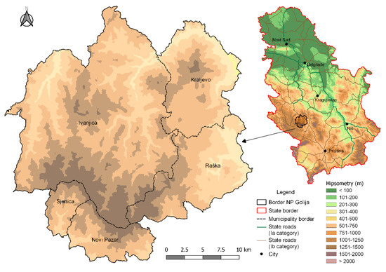
Figure 1.
Geographical Location of the Golija Nature Park.
The settlement network consists mainly of small, scattered rural communities [40], situated at elevations between 1000 and 1800 m. Livestock breeding is the predominant economic activity, while tourism has begun to develop only recently, and rural tourism remains relatively underdeveloped [40]. In peripheral rural areas characterized by low population densities and declining populations, and situated at a considerable distance from larger urban centers, the loss of essential facilities has a particularly profound impact on local communities and their residents [41]. Golija exhibits marked demographic stagnation, distinguishing it from surrounding municipal areas due to several unique characteristics of its population trends (Details regarding the 1953–1961 “compensation period” have been omitted, as they are not essential for the Methods section). However, since 1961, Golija has undergone intensified demographic decline, primarily driven by strong emigration flows, a trend common to many mountainous rural regions. Owing to its exceptional natural and cultural resources, Golija calls for an active and creative human role in the protection and promotion of these assets. Its true value lies in tourism, recreation, and education, which serve as key pillars of the area’s sustainable development [42].
Under the Decree of the Government of the Republic of Serbia [42,43,44], the mountain areas of Golija, Radočelo, and Čemerno were designated as the Golija Nature Park. This territory has been classified as a natural asset of exceptional importance (Category I protection), encompassing a total area of 75,183 hectares (Figure 1) [44,45,46,47,48].
In 2001, a portion of the Golija Nature Park—covering approximately 72.5% of its total area—was designated as the Golija–Studenica Biosphere Reserve under the Act of the International Coordinating Council of the UNESCO MAB Programme [48,49,50]. Subsequently, in 2002, the Government of the Republic of Serbia established the Coordination Committee for the Protection and Development of the Golija Area, with the objective of guiding activities related to the formulation of programmes and planning frameworks for the socio-economic and environmentally sustainable development of the region. This initiative aligns with the UNESCO Biosphere Reserve criteria, aiming to preserve the area’s natural and cultural heritage, enhance the quality of life of local communities, and foster the development of compatible economic and environmental activities [47] (Figure 2).
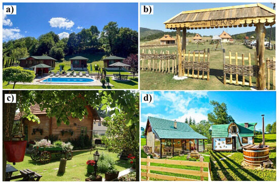
Figure 2.
Ethno Villages in Golija: (a) Golijski Konaci; (b) Šekler Ethno Village; (c) Selena Ethno Village; (d) Fairytale Village.
The area of the park is distinguished by its richness and diversity of both natural and cultural values (Figure 3). Nature-based tourism can be broadly defined as travel to natural destinations where visitors engage in recreational activities that involve incidental interaction with flora and fauna, or where the primary purpose is to gain insight into the natural history of the area and interact meaningfully with its ecosystems [48].
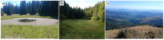
Figure 3.
Natural Heritage Sites in Golija: (a) Dajićko Lake; (b) Košanin’s Lake; (c) Ispod Jankovog Kamena.
In terms of natural values, Golija and Tara together form one of the key centers of genetic, species, and ecosystem diversity in both the Balkans and Europe. About 20% of Serbia’s plant species are present on Golija. Along with Tara, the mountain also represents a major center of Tertiary relics in western Serbia. Notable plant species that characterize the mountain include Greek maple (Acer heldreichii), English holly (Ilex aquifolium), as well as well-preserved deciduous and mixed deciduous–coniferous old-growth (primeval-type) forests and coniferous forests, particularly subalpine spruce stands [33].
Regarding man-made heritage, Golija’s monumental heritage is particularly distinguished, featuring cultural monuments of exceptional importance. The most prominent include the Studenica Monastery (a UNESCO World Heritage Site) and Gradac Monastery [49]. The area also contains diverse and unique archaeological and architectural sites, spanning from prehistory to the modern era, along with well-preserved rural and natural surroundings that maintain their traditional character. In the immediate vicinity of the park, other significant monuments can be found, such as the spatial cultural and historical complex “Ras–Sopoćani” (UNESCO World Heritage Site) [49,50].
In the territory of the Golija Nature Park, three protection regimes have been established, each involving different levels of spatial-use restrictions (Figure 4). The strictest, first-degree regime includes eighteen natural heritage sites with a total area of 553.80 ha, accounting for 0.74% of the park’s territory [40,43,44,45]. The second-degree regime encompasses twenty sites covering 3883.10 ha, or 5.16% of the total area. All remaining parts of the Golija Nature Park fall under the third-degree protection [40,43,44,45].
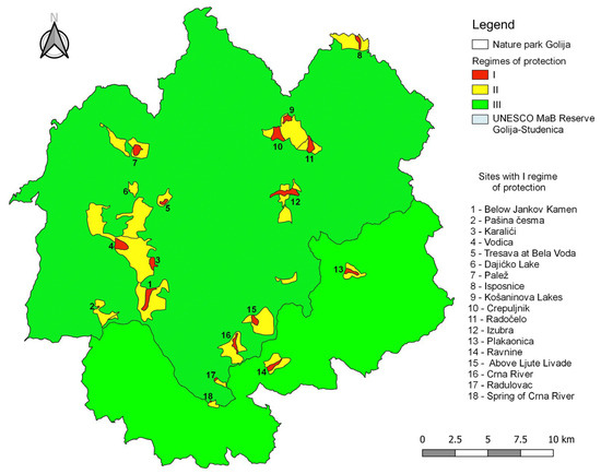
Figure 4.
Protection Zones within the Golija Nature Park.
Of the thirty-eight sites under the first- and second-degree regimes, as many as thirty-four are located within the UNESCO Golija–Studenica Biosphere Reserve [49,50]. Outside its boundaries are the Plakaonica I and Ravnine sites included in the first-degree regime, as well as Plakaonica II and Retko Bučje within the second-degree regime [40,51]. This spatial distribution highlights a strong concentration of the most valuable natural areas within the internationally protected zone.
The subject of this research includes the sites located within the first-degree protection regime. In accordance with the Law on Environmental Protection and relevant by-laws, this regime entails the highest level of spatial conservation, strictly limits the use of natural resources, and excludes all activities except scientific research, controlled educational activities, and the use of existing service and public roads [43,44,45,51]. Such a protection regime enables a reliable assessment of the condition of natural values and an evaluation of their risk of degradation, which forms the basis for defining the methodology and objectives of this research (Table 1).

Table 1.
Natural Heritage Sites within the First-Degree Protection Regime of the Golija Nature Park.
2.2. Methodological Framework
Following the methodology of Brilha (2018), which is widely applied in the assessment of natural values [32,37,43,44,45,51], this study conducted the identification and description of natural heritage sites within Golija Nature Park, based on a review of the literature and field surveys. In recent years, several authors have demonstrated that this framework can be effectively adapted to non-geological natural heritage features in protected mountainous environments [35,36,37]. Geological, geomorphological, speleological, hydrological, and botanical elements were considered, in accordance with the characteristics of the selected sites. The study involved two phases of quantitative evaluation: the assessment of Potential Tourist Use (PTU) and the assessment of Degradation Risk (DR).
2.2.1. Quantitative Assessment of Potential Tourism Use (PTU)
Since the natural heritage sites selected for evaluation are located within a protected, yet economically and demographically degraded rural area, and the original methodology was developed for geosites, certain modifications were made to align it with the objectives and scope of this study. The evaluation was carried out based on 13 defined criteria, with scores ranging from 1 for the lowest to 4 for the highest value. For the final assessment, different weights were assigned to these criteria to better estimate the potential tourist use. The weights were determined based on the literature [31,37,52] and were defined according to the importance of each criterion for assessing potential tourist use (ranging from 5% to 15%).
The landscape criterion received the highest weight (15%) due to its direct influence on visitor experience and its proven relevance in nature-based tourism assessments, where visual quality represents a primary driver of tourist motivation [52]. In establishing the weighting structure, particular consideration was given to the functional relevance of each criterion within the context of tourism development in protected and infrastructurally limited rural areas. Criteria such as accessibility, safety, interpretative potential, uniqueness, and landscape visibility exert a direct and substantial influence on the suitability of a site for tourism activities, while indicators including population density, logistical support, economic development level, and proximity to recreational areas shape tourist potential in a more indirect and contextual manner. Accordingly, the weighting values were derived from established methodological frameworks and empirical evidence from nature-based tourism and geodiversity assessment, supplemented by expert judgement regarding visitor experience, operational feasibility, and long-term sustainability. This combined approach ensured a balanced and methodologically grounded distribution of weights that reflects both the conceptual basis of the assessment model and the specific socio-economic and environmental characteristics of the study area.
The final assessment of the Potential Tourist Use (PTU) represents the result of the weighted sum of all individual scores obtained based on the weighting criteria (Table 2) proposed by Brilha [31], using the following formula:
Table 2.
Criteria, indicators, parameters, and weights used for the quantitative assessment of Potential Tourist Use (PTU) [31].
The obtained results are grouped into three categories: ≤200—the site has low potential for tourism use; >200 ≤300—the site has medium potential; and >300 ≤400—the site has high potential for tourism use. A site has a high potential for tourism use (PTU) when its elements possess exceptional aesthetic value, meaning they are visually appealing to the general public, are easily understandable to visitors without prior geoscientific knowledge, and when the risk of degradation due to human activity is low.
Good infrastructure and favorable visiting conditions are essential and represent a key advantage for the tourism use of a site. This assessment determines the potential tourism use of a site, and based on the obtained results, confirms the justification for developing new or improving existing facilities in order to enhance conditions for visitors.
2.2.2. Quantitative Assessment of Degradation Risk (DR)
As a complement to the assessment of potential tourism use, this study also includes a quantitative assessment of the degradation risk (DR) of the sites. This type of analysis is of great importance for the development and implementation of management plans for specific sites and the area as a whole.
The risk of degradation is influenced by numerous factors, such as human activities [53], number of visitors, proximity to settlements, accessibility [54], as well as other existing or potential threats. Based on his own extensive experience and the practical work of numerous other authors [52,53,55,56,57,58,59,60,61], Brilha (2016) [31] proposed a quantitative method for assessing degradation risk (DR) founded on five key criteria: likelihood of site damage, proximity to areas/activities that may cause degradation, legal protection, accessibility, and population density. In this study, the focus was placed on all forms of natural heritage, and consequently, the methodology was partially modified and adapted (Table 3). Based on the national scale, the parameters for the population density criterion were adjusted. The structure of Brilha’s DR model was retained because it allows consistent evaluation across different types of natural heritage, while maintaining comparability with previous studies.
Table 3.
Criteria/indicators, parameters, and criterion weights used for the quantitative assessment of Degradation Risk (DR) of sites [31].
As Brilha [31] noted when defining the criteria for PTU and DR, the criteria of accessibility and population density are used in both assessments but carry different meanings depending on the context. In the assessment of PTU, good accessibility is considered an advantage, as it facilitates tourist access to the site, while a higher population density is regarded as favorable for educational and tourism-related use. In contrast, when assessing DR, the same accessibility represents a risk, since a greater number of visitors increases the likelihood of site damage. Similarly, a higher population density near the site raises the potential for damage caused by human activities. As with PTU, all criteria were scored on a scale from 1 to 4 points. The final assessment of the Degradation Risk (DR) of a site represents the weighted sum of all individual scores, calculated according to the assigned criterion weights) [31].
The risk of degradation can be classified as low (≤200), moderate (>200 ≤300), and high (>300 ≤400). Such classification can be useful for site management [51,62,63,64]. When there is a high likelihood that the site may be damaged by either natural or anthropogenic factors, when it lacks legal protection, and when it is located near areas or activities that may have harmful impacts, the site reaches the maximum DR value.
3. Results
Based on an extensive review of the scientific literature, field survey reports, and documentation on protected areas within the Golija Nature Park, an assessment of the identified sites was conducted to determine their Potential Tourist Use (PTU). The assessment was carried out using the method defined by Brilha [31], with certain modifications to specific criteria due to the size and characteristics of the study area, as well as the application of the methodology to natural heritage sites.
After conducting the quantitative analysis, it was observed that most sites (16) exhibit medium values of Potential Tourist Use (PTU), indicating the possibility of sustainable tourism development with the implementation of appropriate protection measures. The highest scores were recorded at sites that combine natural and cultural values, such as Dajićko Lake and the Tresava area at Bele Vode, while sites with lower scores generally have limited accessibility and a lower level of tourist infrastructure. These results confirm that spatial and infrastructural characteristics significantly influence the overall value of a site, particularly its usability and interpretative potential.
In the next phase of the research, an assessment (Table 4) of the Degradation Risk (DR) was conducted, enabling an evaluation of the preservation level and vulnerability of the analyzed sites. Through the combined interpretation (PTU and DR), a comprehensive insight was obtained into the possibilities for ecotourism development within the Golija Nature Park, contributing to the definition of priorities in the planning and management of natural assets.
Table 4.
Quantitative assessment of the Potential Tourist Use (PTU) of natural heritage sites in Golija Nature Park.
Of the 18 natural heritage sites analyzed and assessed in Golija Nature Park, two were assigned low values (Crepuljnik and Radočelo). The remaining sites have moderate estimated use values, ranging from 205 points (Vodica and Košanin’s Lakes) to 280 points (Dajićko Lake). The results indicate that sites with higher PTU values exhibit greater attractiveness and potential for inclusion in the tourism offer, but they also require appropriate protection measures and controlled spatial use. Achieving a balance between accessibility and the preservation of natural characteristics provides the foundation for planning sustainable ecotourism development within Golija Nature Park.
As a supplement to the previous PTU analysis, and with the aim of providing a more comprehensive assessment applicable in the development of tourism planning and site management strategies, a Degradation Risk (DR) assessment was also conducted. The risk assessment was conducted using the methodology outlined by Brilha (2016), with certain modifications to adapt it to the size and characteristics of the study area [31]. All 18 sites were evaluated, and the total scores ranged from 115 to 240 points (Figure 5).
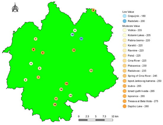
Figure 5.
Estimated PTU of Sites by Category.
Since the scoring scale is the same for both PTU and DR assessments, it is important to note that their values are inversely proportional. In the PTU assessment, a higher score is considered an advantage, as it indicates greater potential for tourism use (Table 5). In contrast, for DR, the risk decreases with lower scores. Fourteen sites were assessed as having a low level of degradation risk, among which three sites—Ispod Jankovog Kamena, Vodica, and Palež—have the highest scores (185), indicating the greatest risk of damage. Four sites were classified in the moderate-risk category: Dajićko Lake, Isposnice, and Crna Reka Spring, which have high potential for tourist use, as does Košanin’s Lakes.
Table 5.
Quantitative Assessment of the Degradation Risk (DR) of Natural Heritage Sites in the Golija Nature Park.
The spatial distribution of degradation risk is not random but is closely related to the intensity of land use and the proximity of main roads and settlements. Sites with higher risk levels, such as Dajićko Lake, Košanin’s Lakes, and the Crna Reka Spring, are located in zones with higher visitor frequency and more pronounced anthropogenic pressure (Figure 6). In contrast, more remote and less accessible sites, such as Radočelo and Crepuljnik, show lower degradation risk but also a lower degree of tourist use. These results highlight the need for a differentiated management approach, in which sites with high potential yet elevated risk should be prioritized for inclusion in protection and sustainable development programs [31].
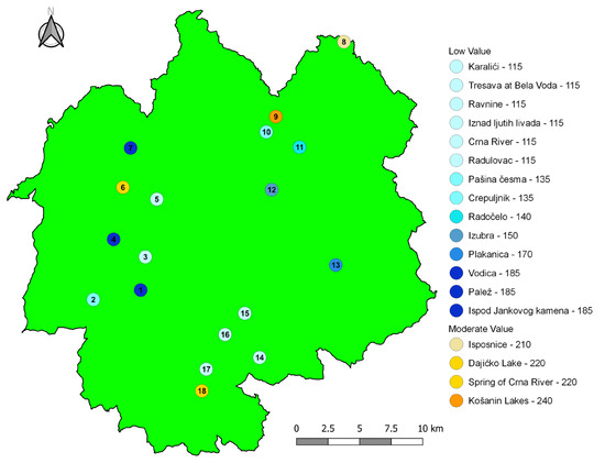
Figure 6.
Estimated Degradation Risk (DR) of Sites by Category.
4. Discussion
In this section, the PTU and DR scores are interpreted in relation to the spatial, ecological, and socio-economic context of the study area, highlighting the implications for tourism development and site management. Of the 18 sites within the Golija Nature Park included in this study, 16 exhibit moderate potential for tourist use (PTU), while only 2 have low potential values. The highest score was recorded for Dajićko Lake (280 points), which achieved maximum values for four criteria. The site is located along the state road IIa (No. 197) Ivanjica–Duga Poljana and is characterized by excellent accessibility. In its immediate vicinity, there are numerous natural features (rivers, lakes, viewpoints, and scenic landscapes) as well as a variety of recreational facilities in the settlement of Dajići (ski slopes, accommodation capacities). The combination of good transport connectivity, the presence of additional surrounding attractions, proximity to recreational facilities, and the high scientific value of the site makes Dajićko Lake the location with the greatest potential for tourist use in the area.
These high-scoring sites illustrate how accessibility, combined values, and the presence of nearby attractions jointly influence PTU outcomes, which is consistent with previous studies on nature-based tourism in mountain areas [6,12,15,16]. The sites Tresava Na Belim Vodama and Gornja Isposnica Svetog Save also stand out with high scores, achieving 275 and 265 points, respectively. The Isposnica site holds great significance in the history of the Serbian people. It is located near the Serbian medieval Studenica Monastery, a UNESCO World Heritage Site [49,50]. In addition to its cultural and religious importance, the area is characterized by a relict forest community. The combination of cultural and natural values, proximity to the settlement of Ušće (which offers a larger number of accommodation facilities), and pronounced landscape and ambient qualities make this site a national attraction with a high overall PTU value.
The Tresava peatland site in Bele Vode is notable for its characteristic peat vegetation, favorable location, and high level of integrity. Situated within the tourist area of Dajići, surrounded by a range of natural and anthropogenic features, it demonstrates a high potential for tourist use [31,49].
Sites Izubra and Iznad Ljutih Livada also stand out with high scores (265 points). Due to its exceptional value, the lower course of the Izubra River has been designated as a hydrological heritage site. It is located near the tourist settlement of Rudno. The combination of significant hydrological and landscape value, along with the site’s favorable position and the presence of both natural and cultural attractions in the vicinity (such as the Pridvorica Monastery), gives Izubra a high potential for tourist use. The site Iznad Ljutih Livada received the same score. Owing to its scientific importance and rarity, it represents the oldest protected area within this region. Furthermore, it is characterized by a high degree of integrity and remarkable landscape value, with several cultural landmarks located nearby, including the Church of Sts. Cosmas and Damian.
The Ispod Jankovog Kamena site records a high score (250 points), primarily due to its location near the highest peak of Mount Golija and in close proximity to the Odvraćenica tourist center. However, the site is not yet developed for tourism and currently serves only as a local attraction.
The Crna Reka Spring site, despite its high hydrological importance, is a common feature in this area. Due to the lack of promotion and valorization and its low integrity, it achieves a moderate potential for tourist use (245 points), even though it lies within the Odvraćenica tourist complex.
Crna Reka Spring, specifically the Radulovac site, received a score of 235 points. It is located within the Odvraćenica tourist center. Plakaonica scored 230 points and has exceptionally high scientific significance. It is situated near the Serbian medieval Gradac Monastery. Despite their location and importance, these two sites have not been developed for tourism and are known only to the local population [56,62,63].
Palež and Crna Reka (225), as well as Ravnine (220), have moderate scores. A common characteristic of Ravnine and Crna Reka is their difficult accessibility. Despite their high ecological and hydrological importance, these sites are known only at the local level. Two additional sites with moderate PTU values are Karalići and Pašina Česma (220 points). Both are characterized by limited accessibility and a lack of promotion and valorization. Similar patterns have been observed in other protected mountain regions, where hydrologically valuable sites often receive moderate PTU scores due to difficult access and limited infrastructure [36,37]. The lowest scores among sites with moderate values were recorded for Vodica and Košanin’s Lakes (205 points). Košanin’s Lakes have significant hydrological and ecological importance, but access to the site is difficult, and there has been little promotion or development of its potential.
Two sites were assessed as having low potential for tourist use: Radočelo (200 points) and Crepuljnik (180 points). Radočelo and Crepuljnik are two spatially connected sites. Their low scores are primarily due to their inaccessible locations, as they cannot be reached by motor vehicles for most of the year.
When it comes to the risk of degradation (DR), four sites show moderate scores. The Isposnice (hermitages) record a moderate degradation risk due to their cultural, historical, and religious importance, which attracts a large number of visitors annually. The site is under strong anthropogenic pressure, and any further increase in visitation could lead to the degradation of the monument and its surrounding landscape. The Dajićko Lake site also shows a moderate degradation risk, influenced by its location near a state road and the intensifying process of eutrophication. Additionally, frequent forest cutting in the surrounding area further threatens the site’s condition. The Košanin’s Lakes have undergone a severe eutrophication process over time. During the summer months, both the Grand and Small Lake often dry up completely, while the surrounding area has become densely overgrown with vegetation. For this reason, Košanin’s Lakes record the highest degradation risk within the area. The spring of the Crna Reka is another site with a moderate degradation risk. Because it is located within the Golija Nature Park tourist center, the high number of visitors and accompanying facilities creates a risk of degradation. All remaining 14 sites show low degradation risk values, indicating a generally well-preserved condition and limited human impact [31,51].
The results indicate that accessibility to most sites is limited. In addition, there is a lack of adequate promotion, valorization, and supporting tourist facilities. As a result, tourist visits are low during certain times of the year. To address this, it is necessary to develop appropriate infrastructure, promote these sites, establish supporting amenities, and present a comprehensive tourism offer. This approach would increase the number of visitors directly, which may contribute to increased visitor numbers and support local economic activity, mitigating depopulation, and indirectly fostering the development of the entire local area.
In this study, the authors applied and tested a methodology originally developed for the quantitative assessment of geosites on natural heritage sites. The methodology, through a wide range of criteria and parameters, clearly demonstrates both the opportunities and limitations for the tourism development of these sites, as well as the needs for their protection and conservation. However, the methodology also has certain limitations when applied to natural heritage sites, and one of the theoretical contributions of this research was to highlight these shortcomings. Moreover, the specific characteristics of the study area—a rural, degraded territory—required modifications to the population density and economic level criteria for PTU, as well as to the population density criterion for DR. Accordingly, instead of the standard scale for population density, the study adopted values based on the national scale:
- -
- The site is located in a settlement with more than 100 inhabitants per km2 (4 points);
- -
- The site is located in a settlement with 25–100 inhabitants per km2 (3 points);
- -
- The site is located in a settlement with 10–25 inhabitants per km2 (2 points);
- -
- The site is located in a settlement with fewer than 10 inhabitants per km2 (1 point).
From a methodological perspective, several adjustments influenced the interpretation of PTU and DR results. Furthermore, since the area is degraded, the scoring scale for the economic criterion parameters has been lowered and is now as follows:
- -
- The site is located in a municipality with a development level above the national average (4 points);
- -
- The site is located in a municipality with a development level ranging from 80% to 100% of the national average (3 points);
- -
- The site is located in a municipality with a development level ranging from 60% to 80% of the national average (2 points);
- -
- The site is located in a municipality with a development level below 60% of the national average (1 point).
The remaining criteria were retained, with the emphasis that further modifications may be necessary for some of them, which could serve as a basis for future research. Regarding the safety criterion, given that the methodology was established in 2016, advancements in technology and increasing tourist expectations suggest that the required parameters could be updated—for example, internet coverage, the presence of rescue services, the availability of tourist guides, and similar elements. For the logistics criterion, depending on the characteristics of the study area, if the area is rural, it would be more appropriate to consider the number of accommodation facilities rather than their capacity, due to the specific nature of rural tourism. The observation conditions criterion cannot be applied objectively to all sites. For instance, in the case of a cave, its value lies in its interior characteristics (number of channels, length, accessibility, presence of stalactites and stalagmites, underground streams). However, PTU and DR scores do not fully capture visitor preferences or the dynamic socio-economic processes influencing protected rural areas, which should be addressed in future research.
The practical contribution of this research is that priorities were identified for each site, both in terms of tourism development and sustainability, as well as for the need for conservation. Accordingly, this study may serve as a basis for planning the protected rural area of the Golija Nature Park and its sustainable development, as well as a starting point for researching other rural, degraded, and depopulating areas.
5. Conclusions
At the beginning of the 21st century, scientists around the world recognized that the concept of sustainable development—which seeks to balance tourism development and nature conservation—is a highly complex mechanism. Achieving positive results requires maintaining a delicate equilibrium between humans and the natural environment. In the decision-making process, it is essential to involve experts from various disciplines as well as the local population, ensuring that management strategies are both scientifically grounded and socially inclusive. Although the concept of sustainable development has been widely promoted in theory over the past two decades, its practical implementation often remains insufficient. Protected areas offer the clearest examples of this gap: while legal regulations prescribe numerous restrictions and protective measures, on-site conditions frequently reveal management challenges and inconsistencies. For this reason, the present study focuses on the Golija Nature Park, incorporating 18 sites under the strictest protection regime, in order to assess their potential for sustainable tourism development and to identify key factors influencing their conservation and use [3,4,10,22].
The findings also carry international relevance, as Golija represents one of the key biodiversity areas of the central Balkans, offering insights applicable to protected mountainous regions globally. The main goal of this study is to highlight the importance of sustainable rural development through ecotourism within a protected area that has been facing significant depopulation in recent years. As the first steps in the decision-making process involve the inventory and quantitative assessment of sites, it is necessary to apply a methodology with clearly defined criteria that evaluates both the potential for tourism development and the possible risk of degradation. For this reason, the study employed, with certain modifications due to the size of the area, the methodology proposed by Brilha [31]. Integrating PTU and DR enabled the identification of sites that combine high development potential with elevated vulnerability, providing clearer priorities for management and conservation planning.
The results show that out of 18 identified sites of natural heritage, as many as 16 have moderate potential for tourist use (PTU). The fact that none of the sites achieved high PTU values can primarily be attributed to the limited accessibility of most locations, as well as the lack of adequate promotion, valorization, and accompanying infrastructure. A positive outcome is that for 14 of the 18 sites, the risk of degradation is either minimal or non-existent, which provides a solid foundation and broad opportunities for their future sustainable development. This study can therefore serve as a baseline for the sustainable development of rural protected areas such as Golija Nature Park, but also as a model applicable to other rural regions affected by depopulation and economic stagnation.
The limitations of this study primarily relate to the relatively small number of analyzed sites, as well as the partial subjectivity present in evaluating certain criteria. Although the method was originally developed for geosites, the findings demonstrate that, with appropriate contextual adjustments, it can be effectively applied to different types of natural heritage. Despite the use of standardized procedures, individual assessments still depend on field observations and the availability of relevant data. Future research should include a larger number of sites, as well as comparative analyses with other mountainous protected areas, in order to further assess the robustness and transferability of the applied methodology.
Author Contributions
Conceptualization, D.V. and M.M.; Methodology, L.M. and D.V.; Software, D.P.; Validation, M.M., L.M. and D.V.; Formal analysis, L.M.; Investigation, L.M. and D.R.; Resources, D.V. and M.M.; Data curation, D.P.; Writing—original draft preparation, L.M.; Writing—review and editing, M.M. and D.V.; Visualization, L.M.; Supervision, M.M.; Project administration, D.V. All authors have read and agreed to the published version of the manuscript.
Funding
This research received no external funding.
Data Availability Statement
The data supporting the findings of this study are derived from official spatial planning and management documents of the Golija Nature Park (Management Plans 2011–2021 and 2021–2030), legal acts of the Government of the Republic of Serbia (Official Gazette Nos. 31/2012, 47/2009, and 16/2009), and UNESCO documentation related to the designation of the Golija–Studenica Biosphere Reserve. No new datasets were created or analyzed during this study.
Acknowledgments
This research was formally conducted within the framework of an institutional project supported by the Ministry of Science, Technological Development, and Innovation of the Republic of Serbia (Contract No. 451-03-65/2025-03/200091). It was also funded by the Ministry of Science, Technological Development, and Innovation of the Republic of Serbia through a contract with the University of Priština, temporarily seated in Kosovska Mitrovica, Faculty of Sciences and Mathematics (Contract No. 451-03-65/2024-03/200123). During the preparation of this manuscript, the authors used OpenAI GPT-5 (October 2025) for minimal linguistic review and editorial refinement to improve the clarity of the text; the authors have reviewed and edited the output and take full responsibility for the content of this publication.
Conflicts of Interest
The authors declare no conflicts of interest.
Abbreviations
The following abbreviations are used in this manuscript:
| PTU | Potential Tourist Use |
| DR | Degradation Risk |
| EEA | European Environment Agency |
| ES | Ecosystem Services |
| UNESCO | United Nations Educational, Scientific and Cultural Organization |
| NP | Nature Park |
| COP | Conference of the Parties |
References
- Zolfani, S.H.; Sedaghat, M.; Maknoon, R.; Zavadskas, E.K. Sustainable tourism: A comprehensive literature review on frameworks and applications. Econ. Res.-Ekon. Istraživanja 2015, 28, 1–30. [Google Scholar] [CrossRef]
- Pérez Guilarte, Y.; Lois González, R.C. Sustainability and visitor management in tourist historic cities: The case of Santiago de Compostela, Spain. J. Herit. Tour. 2018, 13, 489–505. [Google Scholar] [CrossRef]
- United Nations. Sustainable Consumption and Production. Available online: https://www.un.org/sustainabledevelopment/sustainable-consumption-production/ (accessed on 27 October 2025).
- United Nations Statistics Division. The Sustainable Development Goals Report 2025. Available online: https://unstats.un.org/sdgs/report/2025 (accessed on 27 October 2025).
- Khan, M.R.; Khan, H.U.R.; Lim, C.K.; Tan, K.L.; Ahmed, M.F. Sustainable tourism policy, destination management and sustainable tourism development: A moderated-mediation model. Sustainability 2021, 13, 12156. [Google Scholar] [CrossRef]
- Ahmad, A.F.; Khalid Balisany, W.M. Sustainable tourism management and ecotourism as a tool to evaluate tourism’s contribution to the sustainable development goals and local community. OTS Can. J. 2023, 2. [Google Scholar] [CrossRef]
- Peng, X.; Fang, P.; Wan, A.; Lee, S.; Li, Y.; Song, W. Revisiting sustainable tourism: A bibliometric review of key contributors and themes with an integrated framework. Asia Pac. J. Tour. Res. 2025, 1–25. [Google Scholar] [CrossRef]
- GhulamRabbany, M.; Afrin, S.; Rahman, A.; Islam, F.; Hoque, F. Environmental effects of tourism. Am. J. Environ. Energy Power Res. 2013, 1, 117–130. [Google Scholar]
- Baloch, Q.B.; Shah, S.N.; Iqbal, N.; Sheeraz, M.; Asadullah, M.; Mahar, S.; Khan, A.U. Impact of tourism development upon environmental sustainability: A suggested framework for sustainable ecotourism. Environ. Sci. Pollut. Res. 2023, 30, 5917–5930. [Google Scholar] [CrossRef]
- United Nations. Forests, Desertification and Biodiversity. Available online: https://www.un.org/sustainabledevelopment/biodiversity/ (accessed on 27 October 2025).
- Kim, K.; Uysal, M.; Sirgy, M.J. How does tourism in a community impact the quality of life of community residents? Tour. Manag. 2013, 36, 527–540. [Google Scholar] [CrossRef]
- Lee, T.H. Influence analysis of community resident support for sustainable tourism development. Tour. Manag. 2013, 34, 37–46. [Google Scholar] [CrossRef]
- Aleshinloye, K.D.; Woosnam, K.M.; Tasci, A.D.; Ramkissoon, H. Antecedents and outcomes of resident empowerment through tourism. J. Travel Res. 2022, 61, 656–673. [Google Scholar] [CrossRef]
- Andereck, K.L.; Valentine, K.M.; Knopf, R.C.; Vogt, C.A. Residents’ perceptions of community tourism impacts. Ann. Tour. Res. 2005, 32, 1056–1076. [Google Scholar] [CrossRef]
- Ramkissoon, H. Perceived social impacts of tourism and quality-of-life: A new conceptual model. J. Sustain. Tour. 2023, 31, 442–459. [Google Scholar] [CrossRef]
- Gumede, T.K.; Nzama, A.T.; Mdiniso, J.M. Evaluating the effectiveness of the strategies for sustaining nature-based tourism amid global health crises: A global perspective. In Sustaining Nature-Based Tourism Amid Global Crises; IntechOpen: London, UK, 2024. [Google Scholar] [CrossRef]
- Fairbnb.coop. Sustainable Tourism: A Guide for Travellers [Blog Post]. Available online: https://fairbnb.coop/blog/sustainable-tourism/ (accessed on 27 October 2025).
- Boo, E. Ecotourism: The Potentials and Pitfalls; World Wildlife Fund: Washington, DC, USA, 1990; Volume 1. [Google Scholar]
- Lindberg, K.; McCool, S.F. A critique of environmental carrying capacity as a means of managing the effects of tourism development. Environ. Conserv. 1998, 25, 291–292. [Google Scholar] [CrossRef]
- Beeton, S. Ecotourism: A Practical Guide for Rural Communities; Landlinks Press: Collingwood, Australia, 1998. [Google Scholar]
- Çetinkaya, C.; Kabak, M.; Erbaş, M.; Özceylan, E. Evaluation of ecotourism sites: A GIS-based multi-criteria decision analysis. Kybernetes 2018, 47, 1664–1686. [Google Scholar] [CrossRef]
- United Nations. Goal 8: Decent Work and Economic Growth. United Nations—Sustainable Development Goals. Available online: https://www.un.org/sustainabledevelopment/economic-growth/ (accessed on 27 October 2025).
- Budiasa, I.W.; Ambarawati, I.G.A.A. Community-based agro-tourism as an innovative integrated farming system development model towards sustainable agriculture and tourism in Bali. J. Agric. Rural Dev. 2014, 4, 25–36. [Google Scholar]
- Susila, I.; Dean, D.; Harismah, K.; Priyono, K.D.; Setyawan, A.A.; Maulana, H. Does interconnectivity matter? An integration model of agro-tourism development. Asia Pac. Manag. Rev. 2024, 29, 104–114. [Google Scholar] [CrossRef]
- Abbott, M.; Agius, K.; Allen, M.E.; Ariya, G.; Blanco-Gregory, R.; Boyle, C.; Conti, E. Managing visitor experiences in nature based tourism. In Managing Visitor Experiences in Nature-Based Tourism; Albrecht, J.N., Ed.; CABI: Wallingford, UK, 2021; p. 695. [Google Scholar]
- Bichler, B.F.; Peters, M. Soft adventure motivation: An exploratory study of hiking tourism. Tour. Rev. 2021, 76, 473–488. [Google Scholar] [CrossRef]
- Korir, J.; Muchiri, J.; Kamwea, J. Wildlife-based tourism, ecology and sustainability of protected areas in Kenya. J. Nat. Sci. Res. 2013, 3, 40–48. [Google Scholar]
- Bateman, P.W.; Fleming, P.A. Are negative effects of tourist activities on wildlife over-reported? A review of assessment methods and empirical results. Biol. Conserv. 2017, 211, 10–19. [Google Scholar] [CrossRef]
- Nayak, D.; Upadhyay, V.; Puri, B. Tourism at protected areas: Sustainability or policy crunch? IIM Kozhikode Soc. Manag. Rev. 2018, 8, 1–15. [Google Scholar] [CrossRef]
- Wang, C.; Zhang, W.; Gao, Y.; Sun, J. The impact of geographical location of households’ residences on the livelihoods of households surrounding protected areas: An empirical analysis of seven nature reserves across three provinces in China. Land 2025, 14, 1231. [Google Scholar] [CrossRef]
- Brilha, J. Inventory and Quantitative Assessment of Geosites and Geodiversity Sites: A Review. Geoheritage 2016, 8, 119–134. [Google Scholar] [CrossRef]
- Brilha, J.; Gray, M.; Pereira, P. Geodiversity: An Integrative Review as a Contribution to the Sustainable Management of the Whole of Nature. Environ. Sci. Policy 2018, 89, 10–20. [Google Scholar] [CrossRef]
- Gray, M. Geodiversity: The backbone of geoheritage and geoconservation. In Geoheritage; Reynard, E., Brilha, J., Eds.; Elsevier: Amsterdam, The Netherlands, 2018; pp. 13–25. [Google Scholar] [CrossRef]
- Shekhar, S.; Kumar, P.; Chauhan, G.; Thakkar, M.G. Conservation and sustainable development of geoheritage, geopark, and geotourism: A case study of Cenozoic successions of Western Kutch, India. Geoheritage 2019, 11, 1475–1488. [Google Scholar] [CrossRef]
- Ibanez, J.J.; Brevik, E.C. Divergence in natural diversity studies: The need to standardize methods and goals. Catena 2019, 182, 104110. [Google Scholar] [CrossRef]
- Petrović, A.S.; Carević, I.; Trnavac Bogdanović, D.; Langović, M.; Batoćanin, N.; Petronijević, J. Geotourism based on geoheritage as a basis for the sustainable development of the Golija Nature Park, Southwest Serbia. Land 2025, 14, 835. [Google Scholar] [CrossRef]
- Aleksova, B.; Milevski, I.; Lukić, T.; Marković, S.B.; Manevska, I. Preliminary evaluation of geosites for nature-based tourism in Mavrovo and Šar Planina National Parks, North Macedonia. Int. J. Geoheritage Parks 2025, 13, 473–488. [Google Scholar] [CrossRef]
- Marković, J.; Pavlović, M. Geografske Regije Jugoslavije (Srbija i Crna Gora); Savremena Administracija: Beograd, Serbia, 1995. [Google Scholar]
- Gajić, M. Flora i Vegetacija Golije i Javora; Šumarski Fakultet: Ivanjica, Serbia, 1989; p. 592. [Google Scholar]
- CEP. Prostorni Plan Područja Posebne Namene Parka Prirode “Golija”, Predlog Plana, Radna Verzija; Centar za Planiranje Urbanog Razvoja: Beograd, Serbia, 2005. [Google Scholar]
- Haartsen, T.; Gieling, J. Dealing with the loss of the village supermarket: The perceived effects two years after closure. Sociol. Rural. 2021, 61, 561–577. [Google Scholar] [CrossRef]
- Tomić, N.; Stojsavljević, R. Spatial Planning and Sustainable Tourism—A Case Study of Golija Mountain (Serbia). Eur. Res. 2013, 65, 2918–2929. [Google Scholar]
- Official Gazette of the Republic of Serbia 31/2012-3. Decree on Protection Regimes. 2012. Available online: https://www.pravno-informacioni-sistem.rs/SlGlasnikPortal/eli/rep/sgrs/vlada/uredba/2012/31/1 (accessed on 27 October 2025).
- Official Gazette of the Republic of Serbia 47/2009-3. Decree on the Protection of the Nature Park Golija. 2009. Available online: https://www.pravno-informacioni-sistem.rs/SlGlasnikPortal/eli/rep/sgrs/vlada/uredba/2009/47/2 (accessed on 27 October 2025).
- Official Gazette of the Republic of Serbia 16/2009-21. Decree on the Determination of the Spatial Plan of the Special Purpose Area of the Nature Park Golija. 2009. Available online: https://www.pravno-informacioni-sistem.rs/SlGlasnikPortal/eli/rep/sgrs/vlada/uredba/2009/16/7/reg (accessed on 27 October 2025).
- UNESCO. International Coordinating Council of the Man and the Biosphere (MAB) Programme: Designation of the Golija–Studenica Biosphere Reserve; UNESCO: Paris, France, 2001; Available online: https://www.unesco.org/en/mab/golija-studenica (accessed on 27 October 2025).
- Miljanović, D. Golija—Studenica: Geographical Basis of Sustainable Development of the Biosphere Reserve; Institute of Geography, University of Belgrade: Belgrade, Serbia, 2005. [Google Scholar]
- Wolf, I.D.; Croft, D.B.; Green, R. Nature Conservation and Nature-Based Tourism: A Paradox? Environments 2019, 6, 104. [Google Scholar] [CrossRef]
- UNESCO. Studenica Monastery—World Heritage List. Available online: https://whc.unesco.org/en/list/389/ (accessed on 27 October 2025).
- UNESCO. Stari Ras and Sopoćani—World Heritage List. Available online: https://whc.unesco.org/en/list/96/ (accessed on 27 October 2025).
- Nature Park Golija Management Plan for the Period 2021–2030 (2020). Available online: https://srbijasume.rs/ssume/wp-content/uploads/2020/05/PlanUpravGolija.pdf (accessed on 27 October 2025).
- Lima, F.F.; Brilha, J.; Salamuni, E. Inventorying geological heritage in large territories: A methodological proposal applied to Brazil. Geoheritage 2010, 2, 91–99. [Google Scholar] [CrossRef]
- Guju, M.; Mureșan, A.; Doboș, R.; Petrea, D.; Nedelea, A. Evaluating geosites and developing geotourism in the Țara Hațegului region, Romania. Geoheritage 2025, 17, 45–63. [Google Scholar] [CrossRef]
- Fuertes-Gutiérrez, I.; Fernández-Martínez, E. Geosites inventory in the Leon Province (Northwestern Spain): A tool to introduce geoheritage into regional environmental management. Geoheritage 2010, 2, 57–68. [Google Scholar] [CrossRef]
- Fuertes-Gutiérrez, I.; Fernández-Martínez, E. Mapping geosites for geoheritage management: A methodological proposal for the regional park of Picos de Europa (León, Spain). Environ. Manag. 2012, 50, 789–806. [Google Scholar] [CrossRef]
- Cendrero, A. The role of geoscientists in environmental management. Episodes 1996, 19, 82–84. [Google Scholar]
- Carcavilla, L.; López-Martínez, J.; Durán, J.J. Patrimonio Geológico y Geodiversidad: Investigación, Conservación, Gestión y Relación con los Espacios Naturales Protegidos; Instituto Geológico y Minero de España (IGME): Madrid, Spain, 2007. [Google Scholar]
- Reynard, E.; Fontana, G.; Kozlik, L.; Scapozza, C. A method for assessing “scientific” and “additional values” of geomorphosites. Geogr. Helv. 2007, 62, 148–158. [Google Scholar] [CrossRef]
- García-Cortés, A.; Carcavilla Urquí, L. Documentación del Patrimonio Geológico Español: Propuesta de ficha y base de datos para su inventario nacional; Instituto Geológico y Minero de España (IGME): Madrid, Spain, 2009. [Google Scholar]
- Pereira, P.; Pereira, D. Methodological guidelines for geomorphosite assessment. Geogr. Fis. Din. Quat. 2010, 33, 225–230. [Google Scholar] [CrossRef]
- Fassoulas, C.; Mouriki, D.; Dandoulaki, M.; Mountrakis, D. Quantitative assessment of geosites as an effective tool for geoheritage management. Geoheritage 2012, 4, 177–193. [Google Scholar] [CrossRef]
- Maczka, K.; Matczak, P.; Jeran, A.; Chmielewski, P.J. Conflicts in ecosystem services management: Analysis of stakeholder participation in Natura 2000 in Poland. Environ. Sci. Policy 2021, 117, 16–24. [Google Scholar] [CrossRef]
- Eagles, P.E.J.; McCool, S.F. Tourism in National Parks and Protected Areas: Planning and Management; CABI Publishing: Wallingford, UK, 2004. [Google Scholar]
- IUCN. Guidelines for Protected Area Management Categories; IUCN: Gland, Switzerland; Cambridge, UK, 1994. [Google Scholar]


Disclaimer/Publisher’s Note: The statements, opinions and data contained in all publications are solely those of the individual author(s) and contributor(s) and not of MDPI and/or the editor(s). MDPI and/or the editor(s) disclaim responsibility for any injury to people or property resulting from any ideas, methods, instructions or products referred to in the content. |
© 2025 by the authors. Licensee MDPI, Basel, Switzerland. This article is an open access article distributed under the terms and conditions of the Creative Commons Attribution (CC BY) license (https://creativecommons.org/licenses/by/4.0/).