
Permafrost Landscape Research in the Northeast of Eurasia


Abstract
:1. Introduction
2. Materials and Methods
3. Permafrost Landscapes as an Object of Study
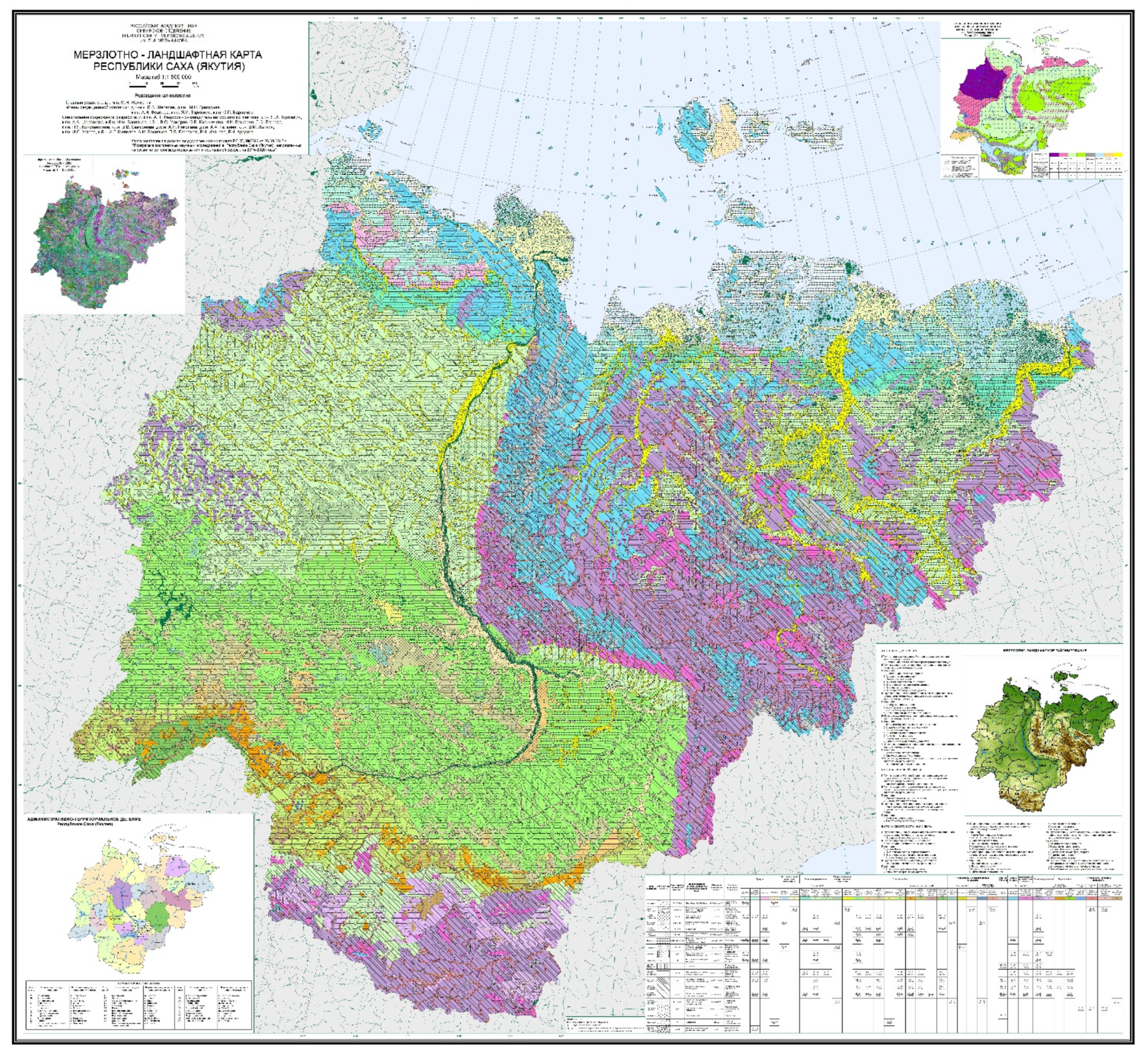
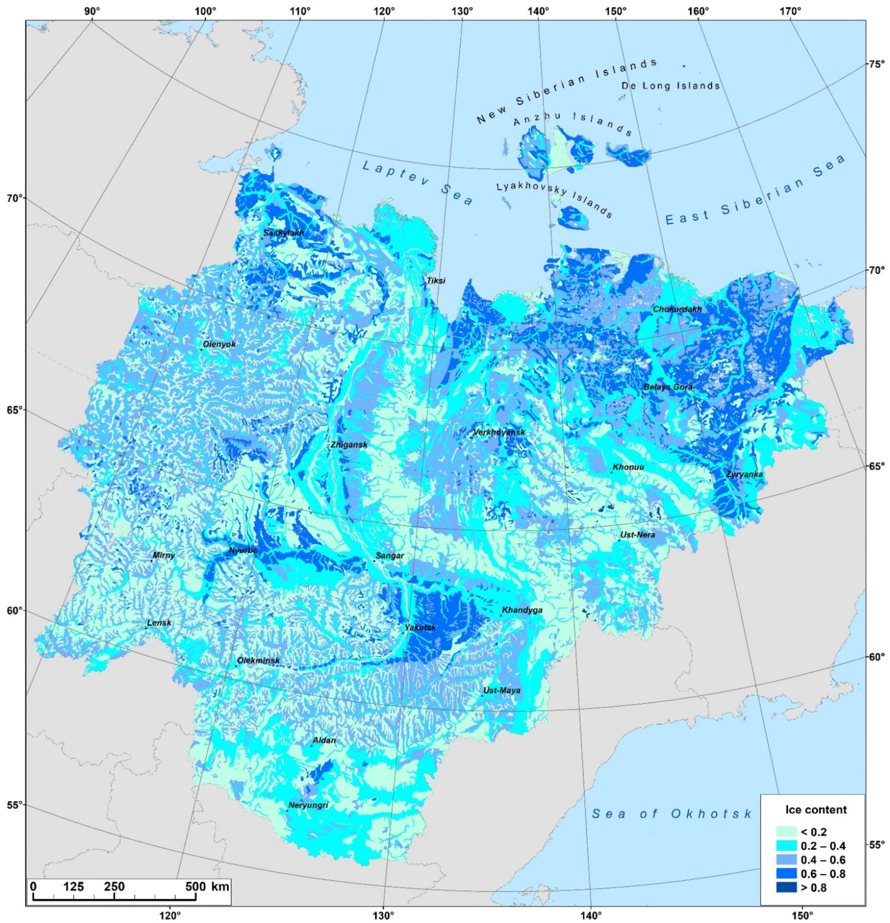
4. Permafrost Landscape Mapping
5. Study of the Dynamics and Evolution of Permafrost Landscapes
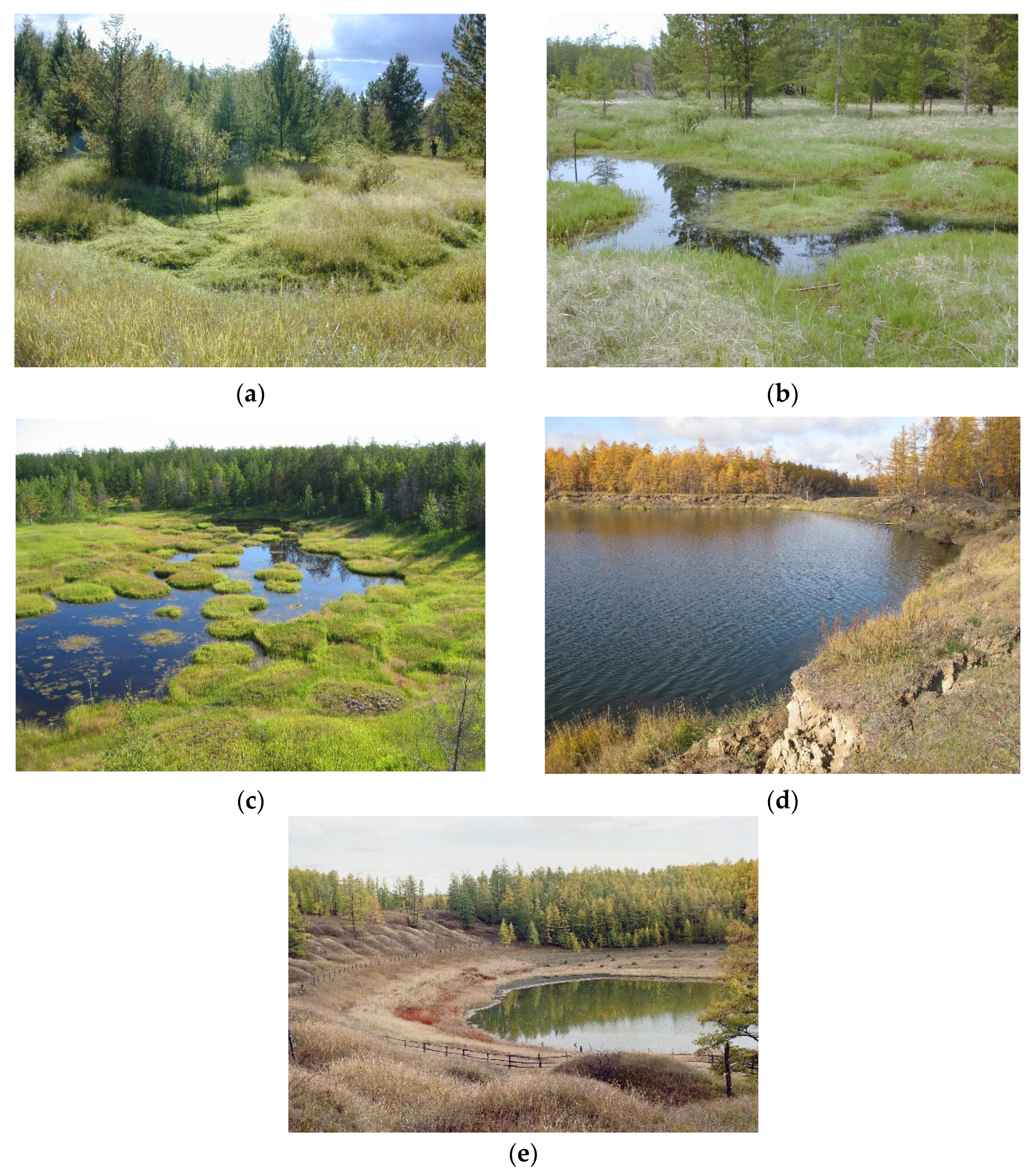
- (1)
- The initial bylar—slightly lowered areas deformed by separate subsidence holes and troughs.
- (2)
- Bylar—lowered areas where the troughs connected, forming a high-centered polygon depression.
- (3)
- Eie is a high-centered polygon depression. In the eie, the troughs between the hillocks are filled with water [110].
- (4)
- Duede is a depression with pronounced banks, with high-centered polygons at the bottom and banks. Efimov and Grave [110] noted that it is filled with water.
- (5)
- Tympy is the first stage of alas. The underground ice at the bottom of the basin melted. The floor of the depression is leveled by alas sediments. The depression is sharply expressed. Usually, tympy is a completely subsided depression with a full lake [110].
- (6)
- Alas is a depression with a relatively flat, leveled floor and steep, sharply defined banks. Evaporation of water forms alas from the tympy [110].
6. Summary
- (1)
- Identifying the permafrost landscape as an object of study complements the theory of landscape science that was strongly developed in the Soviet Union (later in Russia). The parameters of the cryogenic factor have been proposed as criteria for identifying taxonomic units and classifying permafrost landscapes.
- (2)
- The development of permafrost landscape studies made it possible to create mapping based on the classification of permafrost landscapes. Different scale permafrost landscape maps were created that reflected the unity of the morphological parts of the landscape and permafrost. Permafrost landscape maps are mainly used to identify patterns of permafrost differentiation in the environmental assessment in the North.
- (3)
- Permafrost landscapes serve the purpose of illustrating the dynamics and evolution of permafrost. The successional stages in the development of permafrost landscapes indicate permafrost dynamics after disturbances; long-term changes in landscapes relate to permafrost evolution.
Funding
Institutional Review Board Statement
Informed Consent Statement
Data Availability Statement
Acknowledgments
Conflicts of Interest
References
- Tumel, V.F. About permafrost survey. Izv. AN USSR Ser. Geogr. Geophys. 1945, 9, 135–144. (In Russian) [Google Scholar]
- Baranov, I.Y. Goals, and objectives of geocryological survey. In Field Geocryological (Permafrost) Research; Publishing House of the Academy of Sciences of the USSR: Moscow, Russia, 1961; pp. 15–36. (In Russian) [Google Scholar]
- Kudryavtsev, V.A. Permafrost survey as the main type of permafrost research. In Permafrost Research; Kudryavtsev, V.A., Ed.; Moscow State University: Moscow, Russia, 1961; Issue 1, pp. 3–10. (In Russian) [Google Scholar]
- Washburn, A.L. Periglacial Processes and Environment; St. Martin’s Press: New York, NY, USA, 1973; p. 320. [Google Scholar]
- French, H.M. The Periglacial Environment, 3rd ed.; Wiley: New York, NY, USA, 2007; p. 458. [Google Scholar]
- Brown, J.; Grave, N.A. The Surface Disturbance and its Protection at Reclamation of North; Nauka: Novosibirsk, Russia, 1981; p. 88. (In Russian) [Google Scholar]
- Tyrtikov, A.P. The Influence of Vegetation on Freezing and Thawing of Soils; Moscow State University: Moscow, Russia, 1969; p. 192. (In Russian) [Google Scholar]
- Tyrtikov, A.P. Vegetation Dynamics and Development of Permafrost in Western Siberia; Moscow State University: Moscow, Russia, 1974; p. 198. (In Russian) [Google Scholar]
- Tyrtikov, A.P. Vegetation Dynamics and Development of Permafrost Landforms; Nauka: Moscow, Russia, 1979; 116p. (In Russian) [Google Scholar]
- Melnikov, E.S.; Veisman, L.I.; Kritsuk, L.N.; Moskalenko, N.G.; Tagunova, L.N.; Todosiichuk, I.V. Landscape Indicators of Engineering Geocryological Condition of the North of the Western Siberia and Their Interpretive Signs; Nedra: Moscow, Russia, 1974; p. 132. (In Russian) [Google Scholar]
- Melnikov, E.S.; Kritsuk, L.N.; Moskalenko, N.G. Landscape-Indication Method for Engineering-Geocryological Research in Western Siberia. In Landscape Indication of Natural Processes; Nauka: Moscow, Russia, 1976; pp. 88–95. (In Russian) [Google Scholar]
- Melnikov, E.S.; Veisman, L.I.; Moskalenko, N.G.; Tagunova, L.N.; Ukraintseva, N.G.; Chekrygina, S.N.; Ananieva, G.V.; Goralchuk, M.I.; Kritsuk, L.N.; Lazareva, N.A.; et al. Landscapes of Cryolithozone of the West Siberian Gas-Bearing Province; Nauka: Novosibirsk, Russia, 1983; p. 165. (In Russian) [Google Scholar]
- Konstantinova, G.S. Permafrost and landscapes. In Second Intern. Conf. Permafrost. Reports And Messages. Issue. 2. Regional Geocryology; Book Publishing House: Yakutsk, Russia, 1973; pp. 116–120. (In Russian) [Google Scholar]
- Soloviev, P.A. The Cryolithozone of Northern Part of the Lena-Amga Interfluve; Academy of Sciences: Moscow, Russia, 1959; p. 144. (In Russian) [Google Scholar]
- Lugovoi, P.N. Features of the Mountain Permafrost Regions Condition; Nauka: Moscow, Russia, 1970; p. 135. (In Russian) [Google Scholar]
- Fotiev, S.M.; Danilova, N.S.; Sheveleva, N.S. Geocryological Conditions of the Middle Siberia; Nauka: Moscow, Russia, 1974; p. 148. (In Russian) [Google Scholar]
- Nekrasov, I.A. Permafrost of the North-East and the South of Siberia and the Regularities of Its Development; Book Publishing House: Yakutsk, Russia, 1976; p. 246. (In Russian) [Google Scholar]
- Ivanov, M.S. The Cryogenic Structure of Quarternary Deposits of the Leno-Aldan Depression; Nauka: Novosibirsk, Russia, 1984; p. 125. (In Russian) [Google Scholar]
- Lazukova, G.G. Use of vegetation as indicators of permafrost conditions. Bulletin of Moscow State University, Ser. 5. Geography 1967, 4, 54–58. (In Russian) [Google Scholar]
- Moskalenko, N.G. On the influence of vegetation disturbances on the dynamics of seasonal thawing of soils in the northern taiga of Western Siberia. In Landscape Indication of Natural Processes; Chikishev, A.G., Ed.; Nauka: Moscow, Russia, 1976; pp. 144–149. (In Russian) [Google Scholar]
- Moskalenko, N.G. Landscape research in the tundra of the Tazovsky Peninsula. In Proceedings Of VSEGINGEO: Regional Geocryological Research; Zilberbord, A.F., Gravis, G.F., Eds.; VSEGINGEO: Moscow, Russia, 1977; Volume 113, pp. 50–58. (In Russian) [Google Scholar]
- Moskalenko, N.G. Anthropogenic Dynamics of Vegetation in the Plains of the Russian Permafrost; Nauka: Novosibirsk, Russia, 1999; p. 280. (In Russian) [Google Scholar]
- Solntsev, N.A. On the morphology of the natural geographical landscape. In Questions of Geography; Baransky, N.N., Ed.; Geografgiz: Moscow, Russia, 1949; Volume 16, pp. 61–96. (In Russian) [Google Scholar]
- Isachenko, A.G. Landscape Science and Physical-Geographical Zoning; Higher School: Moscow, Russia, 1965; p. 328. (In Russian) [Google Scholar]
- Milkov, F.N. Landscape Geography and Practice Questions; Mysl: Moscow, Russia, 1966; p. 156. (In Russian) [Google Scholar]
- Armand, D.L. Landscape Science; Mysl: Moscow, Russia, 1975; p. 287. (In Russian) [Google Scholar]
- Sochava, V.B. Introduction to the Study of Geosystems; Nauka: Novosibirsk, Russia, 1978; p. 318. (In Russian) [Google Scholar]
- Melnikov, E.S. Scientific Bases and Methods of Regional Engineering-Geological Studies of Cryolithozone’s Plains (on the Example of Western Siberia). Ph.D. Thesis, VSEGINGEO, Moscow, Russia, 1985; p. 44. (In Russian). [Google Scholar]
- Melnikov, E.S.; Goralchuk, M.I.; Kritsuk, L.N.; Ananieva, G.V.; Andrianov, V.N.; Veisman, L.I.; Drozdov, D.S.; Nevecherya, V.L.; Tagunova, L.N.; Ukraintseva, N.G.; et al. Geocryological Conditions of the West Siberian Gas-Bearing Province; Melnikov, E.S., Ed.; Nauka: Novosibirsk, Russia, 1983; p. 199. (In Russian) [Google Scholar]
- Grechischev, S.E.; Moskalenko, N.G.; Shur, Y.L.; Slavin-Borovsky, V.B.; Nevecherya, V.L.; Melnikov, E.S.; Kritsuk, L.N.; Sheshin, Y.B.; Veisman, L.I.; Malevsky-Malevich, S.P.; et al. Geocryological Forecast for the West Siberian Gas-Bearing Province; Grechischev, S.E., Ed.; Nauka: Novosibirsk, Russia, 1983; p. 182. (In Russian) [Google Scholar]
- Drozdov, D.S.; Ukraintseva, N.G.; Tsarev, A.M.; Chekrygina, S.N. Changes in the temperature field of permafrost and the state of geosystems on the territory of the Urengoy field over the past 35 years (1974–2008). Earth Cryosphere 2010, 14, 22–31. (In Russian) [Google Scholar]
- Varlamov, S.; Skachkov, Y.; Skryabin, P. Current climate change effects on the ground thermal regime in Central Yakutia. Sci. Cold Arid. Reg. 2014, 6, 282–292. [Google Scholar]
- Osadchaya, G.G. Permafrost Landscapes of the Bolshezemelskaya Tundra as a Basis for Rational Nature Management. Ph.D. Thesis, Yakutsk University, Ukhta, Russia, 2018; p. 35. (In Russian). [Google Scholar]
- Tumel, N.; Zotova, L. Diagnostics and Mapping of Geoecological Situations in the Permafrost Zone of Russia. Geosciences 2019, 9, 353. [Google Scholar] [CrossRef] [Green Version]
- Lytkina, L.P. Post-fire dynamics of forest growth conditions in the larch forests of Central Yakutia. Geogr. Nat. Resour. 2008, 2, 181–185. (In Russian) [Google Scholar]
- Nikolaev, A.N. Dendrochronological Analysis of Natural Processes in the Cryolithozone (on the Example of Central Yakutia). Ph.D. Thesis, Yakutsk University, Yakutsk, Russia, 2011; p. 40. (In Russian). [Google Scholar]
- Isaev, A.P. Stability of permafrost forests to anthropogenic factors. Successes Mod. Nat. Sci. 2012, 11, 41–43. (In Russian) [Google Scholar]
- Iijima, Y.; Fedorov, A.N. Permafrost-Forest Dynamics. In Ecological Studies. Analysis and Synthesis. Vol. 236. Water and Carbon Dynamics in Eastern Siberia; Takeshi, O., Ed.; Springer Nature: Singapore, 2019; pp. 175–206. [Google Scholar]
- Romanovsky, V.E.; Sazonova, T.S.; Balobaev, V.T.; Shender, N.I.; Sergueev, D.O. Past and recent changes in air and permafrost temperatures in eastern Siberia. Glob. Planet. Chang. 2007, 56, 399–413. [Google Scholar] [CrossRef]
- Beer, C.; Fedorov, A.N.; Torgovkin, Y. Permafrost temperature and active-layer thickness of Yakutia with 0.5-degree spatial resolution for model evaluation. Earth Syst. Sci. Data 2013, 5, 305–310. [Google Scholar] [CrossRef] [Green Version]
- Beer, C.; Porada, P.; Ekici, A.; Brakebusch, M. Effects of short-term variability of meteorological variables on soil temperature in permafrost regions. Cryosphere 2018, 12, 741–757. [Google Scholar] [CrossRef] [Green Version]
- Li, A.; Xia, C.; Bao, C.; Yin, G. Using MODIS Land Surface Temperatures for Permafrost Thermal Modeling in Beiluhe Basin on the Qinghai-Tibet Plateau. Sensors 2019, 19, 4200. [Google Scholar] [CrossRef] [PubMed] [Green Version]
- Fedorov, A.N. Permafrost Landscapes of Yakutia. Classification and Mapping Issues; Permafrost Institute: Yakutsk, Russia, 1991; p. 140. (In Russian) [Google Scholar]
- Murton, J.B. What and where are periglacial landscapes? Permafr. Periglac. Process. 2021, 32, 186–212. [Google Scholar] [CrossRef]
- van Everdingen, R. Multi-language glossary of permafrost and related ground-ice terms. In National Snow and Ice Data Center/World Data Center for Glaciology; World Wide Web Adress: Boulder, CO, USA, 2005. [Google Scholar]
- Grave, N.A. On improving the efficiency of environmental protection measures in the permafrost region. In Methodological Problems of the Development of Science in the Region; Derevyanko, A.P., Solomonov, N.G., Eds.; Nauka: Novosibirsk, Russia, 1987; pp. 129–137. (In Russian) [Google Scholar]
- Zolnikov, V.G. Topography and soil forming deposits in the eastern part of Central Yakutia. In Materials on Environmental Conditions and Agriculture in Central Yakutia; Academy of Science USSR: Moscow, Russia, 1954; Issue 1, pp. 7–54. (In Russian) [Google Scholar]
- Vasiliev, I.S. The Regularities Seasonal Thawing in Eastern; Nauka: Novosibirsk, Russia, 1982; p. 133. (In Russian) [Google Scholar]
- Bosikov, N.P.; Vasiliev, I.S.; Fedorov, A.N. Permafrost Landscapes of Reclaimed Zone of Leno-Aldan Interfluve; Permafrost Institute: Yakutsk, Russia, 1985; p. 124. (In Russian) [Google Scholar]
- Fedorov, A.N.; Botulu, T.A.; Vasiliev, I.S.; Varlamov, S.P.; Gribanova, S.P.; Dorofeev, I.V. Permafrost-Landscape Map of the Yakut ASSR, Scale 1:2,500,000; Melnikov, P.I., Ed.; Gosgeodezia: Moscow, Russia, 1991; 2 Sheet. (In Russian) [Google Scholar]
- Fedorov, A.N.; Botulu, T.A.; Varlamov, S.P.; Vasiliev, I.S.; Gribanova, S.P.; Dorofeev, I.V.; Klimovsky, I.V.; Samsonova, V.V.; Soloviev, P.A. Permafrost Landscapes in Yakutia. Explanation Note to the Permafrost-Landscape Map of the Yakut ASSR at a 1:2,500,000 Scale; GUGK: Novosibirsk, Russia, 1989; p. 170. (In Russian) [Google Scholar]
- Gorokhov, A.N.; Fedorov, A.N.; Skorve, J.; Makarov, V.S. Assessment of anthropogenic variability of landscapes in the vicinity of the Churapcha setttlement (Central Yakutia) based on remote sensing data. Probl. Reg. Ecol. 2011, 4, 7–13. (In Russian) [Google Scholar]
- Shestakova, A.A. Mapping of Permafrost Landscapes Taking into Account Vegetation Successions (on the Example of the Prilensky Plateau). Ph.D. Thesis, Permafrost Institute, Yakutsk, Russia, 2011; p. 20. (In Russian). [Google Scholar]
- Kalinicheva, S.V.; Fedorov, A.N.; Zhelezniak, M.N. Mapping Mountain Permafrost Landscapes in Siberia Using Landsat Thermal Imagery. Geosciences 2018, 9, 4. [Google Scholar] [CrossRef] [Green Version]
- Shestakova, A.; Fedorov, A.; Torgovkin, Y.; Konstantinov, P.; Vasyliev, N.; Kalinicheva, S.; Samsonova, V.; Hiyama, T.; Iijima, Y.; Park, H.; et al. Mapping the Main Characteristics of Permafrost on the Basis of a Permafrost-Landscape Map of Yakutia Using GIS. Land 2021, 10, 462. [Google Scholar] [CrossRef]
- Grave, N.A. Sensitivity of the surface to technogenic impact in the permafrost region, techniques and methods for reflecting it on maps. In Methods of Engineering-Geological Research and Mapping of the Permafrost Region; Kudryavtsev, V.A., Ed.; Permafrost Institute: Yakutsk, Russia, 1978; pp. 16–33. (In Russian) [Google Scholar]
- Grave, N.A. Principles of surface sensitivity evaluation on anthropogenic impacts. In Nature Protection of Yakutia; Andreev, V.N., Sherbakov, I.P., Eds.; Yakutsk Branch of USSR Academy of Sciences: Yakutsk, Russia, 1979; pp. 91–94. (In Russian) [Google Scholar]
- Grave, N.A. Place and direction of geocryological research in the problem of environmental protection and rational use of natural resources in the permafrost region. In Sustainability of the Surface to Technogenic Impacts in the Permafrost Region; Grave, N.A., Turbina, M.I., Eds.; Permafrost Institute: Yakutsk, Russia, 1980; pp. 6–12. (In Russian) [Google Scholar]
- Parmuzin, S.Y.; Sukhodolsky, S.E. Experience in zoning a territory with highly ice-rich deposits in terms of resistance to technogenic impacts (on the example of the Middle Yamal. In Sustainability of the Surface to Technogenic Impacts in the Permafrost Region; Grave, N.A., Turbina, M.I., Eds.; Permafrost Institute: Yakutsk, Russia, 1980; pp. 108–127. (In Russian) [Google Scholar]
- Milkov, F.N. Landscape Sphere of the Earth; Mysl: Moscow, Russia, 1970; p. 207. (In Russian) [Google Scholar]
- Ershov, E.D.; Garagulya, L.S. The main directions of geocryological research at the present stage. In Geocryological Research; Ershov, E.D., Ed.; Moscow State University: Moscow, Russia, 1987; pp. 3–17. (In Russian) [Google Scholar]
- Melnikov, V.P.; Khimenkov, A.N.; Brushkov, A.B.; Vlasov, A.N.; Volkov-Bogorodsky, D.B.; Samsonova, V.V. Cryogenic Geosystems: Research and Modeling Problems; Geo: Novosibirsk, Russia, 2010; p. 390. (In Russian) [Google Scholar]
- Gavrilova, M.K. Modern Climate and Permafrost on the Continents; Nauka: Novosibirsk, Russia, 1981; p. 112. (In Russian) [Google Scholar]
- Popov, A.I. Permafrost Phenomena in the Earth‘s Crust (Cryolithology); Moscow State University: Moscow, Russia, 1967; p. 307. (In Russian) [Google Scholar]
- Popov, A.I. Cryolithogenesis as a zonal type of lithogenesis. In Problems of Geocryology; Nauka: Moscow, Russia, 1983; pp. 35–43. (In Russian) [Google Scholar]
- Katasonov, E.M. Cryolithogenic deposits, their permafrost formation complexes. In Problems of Geocryology; Nauka: Moscow, Russia, 1983; pp. 162–169. (In Russian) [Google Scholar]
- Drozdov, D.S. Identification and Delimitation of Geological Bodies in Medium-Scale Engineering-Geological Mapping Using Mathematical Methods (on the Example of the North of Western Siberia). Ph.D. Thesis, VSEGINGEO, Moscow, Russia, 1983; p. 17. (In Russian). [Google Scholar]
- Milkov, F.N. Man and Landscapes: Essays on Anthropogenic Landscape Science; Mysl: Moscow, Russia, 1973; p. 224. (In Russian) [Google Scholar]
- Milkov, F.N. Anthropogenic landscape science, the subject of study and the current state. In Questions of Geography; Kovalev, S.A., Ed.; Mysl: Moscow, Russia, 1977; Volume 106, pp. 11–27. (In Russian) [Google Scholar]
- Dolgushin, I.Y. Geomorphology of the Western Part of the Aldan Highlands; Publishing House of the Academy of Sciences of the USSR: Moscow, Russia, 1961; p. 206. (In Russian) [Google Scholar]
- Baranova, Y.P.; Biske, S.F. Northeast of the USSR; Nauka: Moscow, Russia, 1964; p. 290. (In Russian) [Google Scholar]
- Timofeev, D.A. Middle and Lower Olekma; Nauka: Moscow-Leningrad, Russia, 1965; p. 138. (In Russian) [Google Scholar]
- Rusanov, B.S.; Borodenkova, Z.F.; Goncharov, V.F.; Grinenko, O.V.; Lazarev, P.A. Geomorphology of Eastern Yakutia; Book Publishing House: Yakutsk, Russia, 1967; p. 376. (In Russian) [Google Scholar]
- Belokrylov, I.D.; Efimov, A.I. Permafrost of the Zone of Iron Ore and Coal Deposits of Yakutia; Publishing House of the Academy of Sciences of the USSR: Moscow, Russia, 1960; p. 75. (In Russian) [Google Scholar]
- Kachurin, S.P. Thermokarst on the Territory of the USSR; Publishing House of the Academy of Sciences of the USSR: Moscow, Russia, 1961; p. 290. (In Russian) [Google Scholar]
- Trush, N.I.; Chizhov, A.B.; Chizhova, N.I.; Vsevozhskaya, M.A.; Pavlova, O.P.; Khrutsky, S.F.; Piotrovsky, M.V.; Kondratieva, K.A.; Melentiev, V.S.; Gavrilov, A.V.; et al. South Yakutia; Kudryavtsev, V.A., Ed.; Moscow State University: Moscow, Russia, 1975; p. 444. (In Russian) [Google Scholar]
- Katasonov, E.M.; Ivanov, M.S.; Pudov, U.U.; Katasonova, E.G.; Siegert, C. Structure and Absolute Geochronology of Alas Deposits in Central Yakutia; Katasonov, E.M., Ed.; Nauka: Novosibirsk, Russia, 1979; p. 95. (In Russian) [Google Scholar]
- Ospennikov, E.N.; Trush, N.I.; Chizhov, A.B.; Chizhova, N.N. Exogenous Geological Processes and Phenomena (South Yakutia); Moscow State University: Moscow, Russia, 1980; p. 227. (In Russian) [Google Scholar]
- Tomirdiaro, S.V. Loess-ice formation of Eastern Siberia in the Late Pleistocene and Holocene; Nauka: Moscow, Russia, 1980; p. 184. (In Russian) [Google Scholar]
- Zolnikov, V.G. Soils of the eastern half of Central Yakutia and their use. In Materials on Environmental Conditions and Agriculture in Central Yakutia; Academy of Science USSR: Moscow, Russia, 1954; Issue 1, pp. 55–221. (In Russian) [Google Scholar]
- Zolnikov, V.G.; Elovskaya, L.G.; Teterina, L.V.; Chernyak, E.I. Soils of the Vilyui Basin and Their Use; Academy of Science USSR: Moscow, Russia, 1962; p. 204. (In Russian) [Google Scholar]
- Karavaeva, N.A. Tundra soils of Northern Yakutia; Nauka: Moscow, Russia, 1969; p. 205. (In Russian) [Google Scholar]
- Savvinov, D.D. The Hydrothermal Regime of Soils in the Permafrost Zone; Nauka: Novosibirsk, Russia, 1976; p. 254. (In Russian) [Google Scholar]
- Elovskaya, L.G.; Petrova, E.I.; Teterina, L.V. Soil map of Yakutia. In Study of Biological Resources in Yakutia; Yakutsk Branch Academy of Sciences: Yakutsk, Russia, 1978; pp. 4–13. (In Russian) [Google Scholar]
- Desyatkin, R.V. Soils of the Alasses of the Lena-Amga Interfluve; Yakutsk Branch Academy of Sciences: Yakutsk, Russia, 1984; p. 168. (In Russian) [Google Scholar]
- Sheludyakova, V.A. Vegetation of the Verkhoyansk Region of the Yakut ASSR.; YakutGIZ: Yakutsk, Russia, 1948; p. 68. (In Russian) [Google Scholar]
- Sheludyakova, V.A. Steppe vegetation of the Yakut Arctic. In Proceedings of the Institute of Biology of Yakut branch Academy of Sciences of the USSR. Issue 3: Materials for the Study of the Vegetation of Yakutia; Publishing House of the Academy of Sciences of the USSR: Moscow, Russia, 1957; pp. 68–82. (In Russian). [Google Scholar]
- Kuvaev, V.B. Vegetation of the eastern Verkhoyansk region. In Vegetation of the Far North of the USSR and its Development; Publishing House of the Academy of Sciences of the USSR: Moscow-Leningrad, Russia, 1956; Issue 2, pp. 133–186. (In Russian) [Google Scholar]
- Kuvaev, V.B. Regularities in the distribution of vegetation cover in Western Verkhoyansk region. In Problems of Botany. Vol.5: Materials for the Study of Flora and Vegetation of High Mountains; Tolmachev, A.I., Ed.; Publishing House of the Academy of Sciences of the USSR: Moscow-Leningrad, Russia, 1960; pp. 72–84. (In Russian) [Google Scholar]
- Kuvaev, V.B. Vegetation classification of the southern part of Yakutia on a landscape basis. Bot. J. 1966, 51, 1564–1579. (In Russian) [Google Scholar]
- Sheludyakova, V.A.; Galaktionova, T.F.; Dobretsova, L.A.; Permyakova, A.A.; Usanova, V.M. Vegetation of the Vilyui River Basin; Shcherbakov, I.P., Ed.; Publishing House of the Academy of Sciences of the USSR: Moscow-Leningrad, Russia, 1962; p. 136. (In Russian) [Google Scholar]
- Shcherbakov, I.P. Forest cover of the North-East of the USSR; Nauka: Novosibirsk, Russia, 1975; p. 344. (In Russian) [Google Scholar]
- Andreev, V.N.; Galaktionova, T.F.; Karpel, B.A.; Perfilieva, V.I.; Chugunova, R.V.; Shurduk, I.F. Vegetation map. In Agricultiral Atlas of Yakut ASSR; Matveev, I.A., Ed.; GUGK: Moscow, Russia, 1989; pp. 42–43. (In Russian) [Google Scholar]
- Mikhailov, N.I. Physical-geographical zoning of the Yakut ASSR. In Materials on the Physical-Geographical Zoning of the USSR (Siberia and The Far East); Gvozdetsky, N.A., Ed.; Moscow State University: Moscow, Russia, 1964; pp. 71–129. (In Russian) [Google Scholar]
- Parmuzin, Y.P. Central Siberia. In Physico-Geographical Zoning of the USSR; Gvozdetsky, N.A., Ed.; Moscow State University: Moscow, Russia, 1968; pp. 341–381. (In Russian) [Google Scholar]
- Parmuzin, Y.P. Central Yakut country. In Physical-Geographical Zoning of the USSR; Gvozdetsky, N.A., Ed.; Moscow State University: Moscow, Russia, 1968; pp. 382–395. (In Russian) [Google Scholar]
- Mikheev, V.S.; Pavlov, P.D. Physical-geographical zoning. In Atlas of the Yakut ASSR; Sivtsev, T.D., Ed.; GUGK: Moscow, Russia, 1981; p. 22. (In Russian) [Google Scholar]
- Fedorov, A.N. The role of logging in the development of permafrost landscapes in Central Yakutia. In Regional and Engineering Permafrost Investigations in Yakutia; Klimovsky, I.V., Kuzmin, G.P., Eds.; Permafrost Institute: Yakutsk, Russia, 1985; pp. 111–117. (In Russian) [Google Scholar]
- Varlamov, S.P. Landscape typological mapping as a basis for stationary research extrapolation. In Regional and Engineering Geocryological Studies; Klimovsky, I.V., Kuzmin, G.P., Eds.; Permafrost Institute: Yakutsk, Russia, 1985; pp. 132–137. (In Russian) [Google Scholar]
- Fedorov, A.N.; Maximov, T.C.; Gavriliev, P.P.; Skachkov, Y.B.; Ugarov, I.S.; Desyatkin, R.V.; Isaev, A.P.; Vasiliev, I.S.; Konstantinov, P.Y.; Rusakov, V.G.; et al. Spasskaya Pad: Comprehensive Studies of Permafrost Landscapes; Gavrilova, M.K., Konstantinov, P.Y., Shats, M.M., Eds.; Permafrost Institute: Yakutsk, Russia, 2006; p. 210. (In Russian) [Google Scholar]
- Shats, M.M.; Dorofeev, I.V.; Fedorov, A.N. Experience the landscape and permafrost mapping SouthernYakutia. In Natural Conditions Reclaimed Regions of Siberia; Klimovsky, I.V., Pozdnyakova, E.S., Eds.; Permafrost Institute: Yakutsk, Russia, 1987; pp. 49–55. (In Russian) [Google Scholar]
- Torgovkin, Y.I. Landscape Indication and Mapping Permafrost Conditions of the Lena River Basin. Ph.D. Thesis, Permafrost Institute, Yakutsk, Russia, 2005; p. 20. (In Russian). [Google Scholar]
- Gorokhov, A.N.; Makarov, V.S.; Vasiliev, N.F.; Fedorov, A.N. Methodical approaches to compiling a landscape map based on GIS technologies (on the example of the Neryungri industrial complex of Yakutia). Probl. Reg. Ecol. 2009, 3, 15–19. (In Russian) [Google Scholar]
- Fedorov, A.N.; Torgovkin, Y.I. Variety of permafrost landscapes of the Lena river basin. In Scientific Readings Devoted to the 100th Anniversary of the Birth of Academician Viktor Borisovich Sochava: Materials of the International Conference, Irkutsk, 20–21 June 2005; Snytko, V.A., Ed.; Institute of Geography of the Siberian Branch of the Russian Academy of Sciences: Irkutsk, Russia, 2005; pp. 39–42. (In Russian) [Google Scholar]
- Fedorov, A.N.; Vasilyev, N.F.; Torgovkin, Y.I.; Shestakova, A.A.; Varlamov, S.P.; Zheleznyak, M.N.; Shepelev, V.V.; Konstantinov, P.Y.; Kalinicheva, S.V.; Basharin, N.I.; et al. Permafrost-landscape map of the Republic of Sakha (Yakutia) at scale 1:1,500,000. Geosciences 2018, 8, 465. [Google Scholar] [CrossRef] [Green Version]
- Shmelev, D.; Veremeeva, A.; Kraev, G.; Kholodov, A.; Spencer, R.G.M.; Walker, W.S.; Rivkina, E. Estimation and Sensitivity of Carbon Storage in Permafrost of North-Eastern Yakutia. Permafr. Periglac. Process. 2017, 28, 379–390. [Google Scholar] [CrossRef]
- Maslakov, A.; Zotova, L.; Komova, N.; Grishchenko, M.; Zamolodchikov, D.; Zelensky, G. Vulnerability of the Permafrost Landscapes in the Eastern Chukotka Coastal Plains to Human Impact and Climate Change. Land 2021, 10, 445. [Google Scholar] [CrossRef]
- Maslakov, A.; Shabanova, N.; Zamolodchikov, D.; Volobuev, V.; Kraev, G. Permafrost Degradation within Eastern Chukotka CALM Sites in the 21st Century Based on CMIP5 Climate Models. Geosciences 2019, 9, 232. [Google Scholar] [CrossRef] [Green Version]
- Strauss, J.; Laboor, S.; Schirrmeister, L.; Fedorov, A.N.; Fortier, D.; Froese, D.; Fuchs, M.; Günther, F.; Grigoriev, M.; Harden, J.; et al. Circum-Arctic Map of the Yedoma Permafrost Domain. Front. Earth Sci. 2021, 9, 758360. [Google Scholar] [CrossRef]
- Efimov, A.I.; Grave, N.A. Buried ice in the area of Abalakh lake. In Socialist Construction; SNK & GosPlan YaASSR: Yakutsk, Russia, 1940; pp. 65–78. (In Russian) [Google Scholar]
- Czudek, T.; Demek, J. Thermokarst in Siberia and Its Influence on the Development of Lowland Relief. Quat. Res. 1970, 1, 103–120. [Google Scholar] [CrossRef]
- Soloviev, P.A. Alas relief of Central Yakutia and its origin. In Permafrost and Accompanying Phenomena on the Territory of the Yakut ASSR; Grave, N.A., Ed.; Publishing House of the Academy of Sciences of the USSR: Moscow, Russia, 1962; pp. 38–53. (In Russian) [Google Scholar]
- Khotinsky, N.A. Holocene of Northern Eurasia; Nauka: Moscow, Russia, 1977; p. 199. (In Russian) [Google Scholar]
- Andreev, A.A. History of vegetation and climate of Central Yakutia in the Holocene and Late Glacial. In Lakes of Cold Regions, Proceedings of Int. Conf. Part 4: Issues of Paleoclimatology, Paleolimnology and Paleoecology; Yakutsk State University: Yakutsk, Russia, 2000; pp. 15–29. (In Russian) [Google Scholar]
- Andreev, A.A.; Klimanov, V.A.; Sulerzhitskiy, L.D. The history of vegetation and climate of central Yakutia over the past 11,000 years. In Geochronology of the Quaternary; Ivanova, I.K., Kind, I.V., Eds.; Nauka: Moscow, Russia, 1992; pp. 113–117. (In Russian) [Google Scholar]
- Andreev, A.; Klimanov, V.; Sulerzhitsky, L. Vegetation and climate history of the Yana River lowland, Russia, during the last 6400yr. Quat. Sci. Rev. 2001, 20, 259–266. [Google Scholar] [CrossRef]
- Klimanov, V.A. Paleoclimate of Northern Eurasia with an increase in mean global temperature of 0.6–0.8oC or less. In Climates and Landscapes of Northern Eurasia in a Global Warming Condition. Retrospective Analysis and Scenarios. Atlas-Monograph “Development of Landscapes and Climate of Northern Eurasia. Late Pleistocene—Holocene—Prediction Elements”; Velichko, A.A., Ed.; GEOS: Moscow, Russia, 2010; Volume 3, pp. 70–86. (In Russian) [Google Scholar]
- Fedorov, A.N.; Novopriezzhaya, V.A.; Fedorov, N.A.; Konstantinov, P.Y.; Samsonova, V.V. Retrospective Analysis of Permafrost Landscape Evolution in Yakutia during the Holocene Warm Intervals. Land 2020, 9, 463. [Google Scholar] [CrossRef]
- Fotiev, S.M. Modern conceptions of the evolution of cryogenic area of West and East Siberia in Pleistocene and Holocene (report 2). Earth Cryosphere 2006, 10, 3–26. (In Russian) [Google Scholar]
- Karabanov, E.B.; Kuzmin, M.I.; Williams, D.F.; Khursevich, G.K.; Bezrukova, E.V.; Prokopenko, A.A.; Kerber, E.A.; Gvozdkov, A.N.; Geletyi, V.F.; Veil, D.; et al. Global cooling of Central Asia in the Late Cenozoicaccording to the sedimentary record from Lake Baikal. Doklady RAS 2000, 370, 61–66. (In Russian) [Google Scholar]
- Stashenko, A.I. Study of transformation of permafrost conditions during of reclamation of forest natural complexes in the south of the Central Yakutia. In Cryogenic Physio-Geological Processes and Methods for the Study Their Development; Grechishev, S.E., Ed.; USSR’s Scientific Institute of Hydrology and Engineering Geology: Moscow, Russia, 1987; pp. 93–100. (In Russian) [Google Scholar]
- Varlamov, S.P.; Skryabin, P.N. Post-fire changes in the hydrothermal state of permafrost in Yakutia. Adv. Curr. Nat. Sci. 2016, 5, 105–110. (In Russian) [Google Scholar]
- Fedorov, A.; Konstantinov, P.; Vasilyev, N.; Shestakova, A. The influence of boreal forest dynamics on the current state of permafrost in Central Yakutia. Polar Sci. 2019, 22, 100483. [Google Scholar] [CrossRef]
- Lytkina, L.P.; Mironova, C.I. Post-fire succession in permafrost forests (on the example of Central Yakutia). Ecology 2009, 3, 168–173. (In Russian) [Google Scholar]
- Gabysheva, L.P. Changes in the phytomass of the living ground cover after fires in the larch forests of Central Yakutia. Sci. Educ. 2013, 4, 62–65. (In Russian) [Google Scholar]
- Iwahana, G.; Machimura, T.; Kobayashi, Y.; Fedorov, A.; Konstantinov, P.; Fukuda, M. Influence of forest clear-cutting on the thermal and hydrological regime of the active layer near Yakutsk, eastern Siberia. J. Geophys. Res. 2005, 110, GO2004. [Google Scholar] [CrossRef]
- Fedorov, A.N.; Iwahana, G.; Konstantinov, P.Y.; Machimura, T.; Argunov, R.; Efremov, P.V.; Lopez, L.M.C.; Takakai, F. Variability of Permafrost and Landscape Conditions Following Clear Cutting of Larch Forest in Central Yakutia. Permafr. Periglac. Process. 2017, 28, 331–338. [Google Scholar] [CrossRef]
- Usoltsev, V.A. Forest Biomass of Northern Eurasia: Mensuration Standards and Geography; Ural Branch of RAS: Yekaterinburg, Russia, 2002; p. 763. (In Russian) [Google Scholar]
- Shvidenko, A.Z.; Schepaschenko, D.G.; Nilsson, S.; Buluy, Y.I. Tables and Models of Growth and Productivity of Forests of Major Forest Forming Species of Northern Eurasia (Standard and Reference Materials), 2nd ed.; Federal Agency of Forest Management: Moscow, Russia, 2006; p. 803. (In Russian) [Google Scholar]
- Berner, L.T.; Beck, P.S.A.; Loranty, M.M.; Alexander, H.D.; Mack, M.C.; Goetz, S.J. Cajander larch (Larix cajanderi) biomass distribution, fire regime and post-fire recovery in northeastern Siberia. Biogeosciences 2012, 9, 3943–3959. [Google Scholar] [CrossRef] [Green Version]
- Alexander, H.D.; Natali, S.M.; Loranty, M.; Ludwig, S.; Spektor, V.; Davydov, S.; Zimov, N.; Trujillo, I.; Mack, M.C. Impacts of increased soil burn severity on larch forest regeneration on permafrost soils of far northeastern Siberia. For. Ecol. Manag. 2018, 417, 144–153. [Google Scholar] [CrossRef]
- Varlamov, S.P.; Skachkov, Y.B.; Skryabin, P.N. Results of 35-year monitoring studies of the permafrost zone at the Chabyda station (Central Yakutia). Sci. Educ. 2017, 2, 34–40. (In Russian) [Google Scholar]
- Varlamov, S.P.; Skachkov, Y.B.; Skryabin, P.N. Monitoring of the Thermal Regime of Grounds in Central Yakutia; Permafrost Institute: Yakutsk, Russia, 2021; p. 156. (In Russian) [Google Scholar]
- Fedorov, A.; Ivanova, R.; Park, H.; Hiyama, T.; Iijima, Y. Recent air temperature changes in the permafrost landscapes of northeastern Eurasia. Polar Sci. 2014, 8, 114–128. [Google Scholar] [CrossRef] [Green Version]
- Romanovsky, V.E.; Drozdov, D.S.; Oberman, N.G.; Malkova, G.V.; Kholodov, A.L.; Marchenko, S.; Moskalenko, N.G.; Sergeev, D.O.; Ukraintseva, N.G.; Abramov, A.; et al. Thermal state of permafrost in Russia. Permafr. Periglac. Process. 2010, 21, 136–155. [Google Scholar] [CrossRef]
- Walter, K.M.; Zimov, S.A.; Chanton, J.P.; Verbyla, D.; Chapin, F.S. Methane Bubbling from Siberian Thaw Lakes as a Positive Feedback to Climate Warming. Nature 2006, 443, 71–75. [Google Scholar] [CrossRef]
- Morgenstern, A.; Grosse, G.; Gunther, F. Spatial analyses of thermokarst lakes and basins in Yedoma landscapes of the Lena Delta. The Cryosphere 2011, 5, 849–867. [Google Scholar] [CrossRef] [Green Version]
- van Huissteden, J.; Mi, Y.; Gallagher, A.; Budishev, A. The importance of ecosystem covery for quantification of greenhouse gas fluxes from permafrost degradation. In Proceedings of the 1st International Conference Global Warming and the Human Nature Dimension in Siberia: Social Adaptation to the Changes of the Terrestrial Ecosystem, with an Emphasis on Water Environments, Kyoto, Japan, 7–9 March 2012; pp. 48–50. [Google Scholar]
- Boike, J.; Grau, T.; Heim, B.; Günther, F.; Langer, M.; Muster, S.; Gouttevin, I.; Lange, S. Satellite-derived changes in the permafrost landscape of central Yakutia, 2000–2011: Wetting, drying, and fires. Glob. Planet. Change 2016, 139, 116–127. [Google Scholar] [CrossRef] [Green Version]
- Lapenis, A.; Shvidenko, A.; Shepaschenko, D.; Nilsson, S.; Aiyyer, A. Acclimation of Russian forests to recent changes in climate. Glob. Change Biol. 2005, 11, 2090–2102. [Google Scholar] [CrossRef] [PubMed]
- Kudryavtsev, V.A.; Garagulya, L.S.; Kondratieva, K.A.; Romanovskyi, N.N.; Maksimova, L.N.; Chizhov, A.B. Methods of Permafrost Survey; Moscow State University: Moscow, Russia, 1979; p. 358. (In Russian) [Google Scholar]
- Feldman, G.M.; Tetelbaum, A.S.; Shender, N.I.; Gavriliev, R.I. Guidelines for Predicting the Ground Temperature Regime in Yakutia; Permafrost Institute: Yakutsk, Russia, 1988; p. 240. (In Russian) [Google Scholar]
- Hill, G.B.; Henry, G.H.R. Responses of High Arctic wet sedge tundra to climate warming since 1980. Glob. Change Biol. 2010, 17, 276–287. [Google Scholar] [CrossRef]
- Vaganov, A.A.; Shiyatov, S.G.; Mazepa, V.S. Dendroclimatic Research in the Ural-Siberian Subarctic; Nauka: Novosibirsk, Russia, 1996; p. 244. (In Russian) [Google Scholar]
- Esper, J.; Frank, D.; BãNtgen, U.; Verstege, A.; Hantemirov, R.M.; Kirdyanov, A.V. Trends and uncertainties in Siberian indicators of 20th century warming. Glob. Chang. Biol. 2009, 16, 386–398. [Google Scholar] [CrossRef]
- Blok, D.; Heijmans, M.M.P.D.; Schaepman-Strub, G.; Kononov, A.; Maximov, T.C.; Berendse, F. Shrub expansion may reduce summer permafrost thaw in Siberian tundra. Glob. Change Biol. 2010, 16, 1296–1305. [Google Scholar] [CrossRef]
- Makarov, V.; Savvinov, G.; Gavrilieva, L.; Gololobova, A. The Effect of Grazing on the Temperature Regime of the Alas Soils of Central Yakutia. Land 2020, 9, 365. [Google Scholar] [CrossRef]
- Takakai, F.; Desyatkin, A.R.; Lopez, C.M.L.; Fedorov, A.N.; Desyatkin, R.V.; Hatano, R. Influence of forest disturbance on CO2, CH4 and N2O fluxes from larch forest soil in the permafrost taiga region of eastern Siberia. Soil Sci. Plant Nutr. 2008, 54, 938–949. [Google Scholar] [CrossRef]
- Loranty, M.M.; Berner, L.T.; Taber, E.D.; Kropp, H.; Natali, S.M.; Alexander, H.D.; Davydov, S.P.; Zimov, N.S. Understory vegetation mediates permafrost active layer dynamics and carbon dioxide fluxes in open-canopy larch forests of northeastern Siberia. PLoS ONE 2018, 13, e0194014. [Google Scholar] [CrossRef] [Green Version]
- Masyagina, O.V.; Menyailo, O.V. The impact of permafrost on carbon dioxide and methane fluxes in Siberia: A meta-analysis. Environ. Res. 2020, 182, 109096. [Google Scholar] [CrossRef]
- Shepelev, A.G.; Kizyakov, A.; Wetterich, S.; Cherepanova, A.; Fedorov, A.; Syromyatnikov, I.; Savvinov, G. Sub-Surface Carbon Stocks in Northern Taiga Landscapes Exposed in the Batagay Megaslump, Yana Upland, Yakutia. Land 2020, 9, 305. [Google Scholar] [CrossRef]
- Brouchkov, A.; Fukuda, M. Preliminary measurements on methane content in permafrost, Central Yakutia, and some experimental data. Permafr. Periglac. Process. 2002, 13, 187–197. [Google Scholar] [CrossRef]
- Kraev, G.N.; Schultze, E.D.; Rivkina, E.M. Cryogenesis as a factor of methane distribution in layers of permafrost. Dokl. Earth Sci. 2013, 451, 882–885. [Google Scholar] [CrossRef]
- Yang, J.-W.; Ahn, J.; Iwahana, G.; Han, S.; Kim, K.; Fedorov, A. Brief Communication: The reliability of gas extraction techniques for analyzing CH4 and N2O compositions in gas trapped in permafrost ice wedges. Cryosphere 2020, 14, 1311–1324. [Google Scholar] [CrossRef] [Green Version]
- Desyatkin, A.R.; Takakai, F.; Fedorov, P.P.; Nikolaeva, M.C.; Desyatkin, R.V.; Hatano, R. CH4emission from different stages of thermokarst formation in Central Yakutia, East Siberia. Soil Sci. Plant Nutr. 2009, 55, 558–570. [Google Scholar] [CrossRef] [Green Version]
- Desyatkin, A.P.; Takakai, F.; Hatano, R. Flood effect on CH4 emission from the alas in Central Yakutia, East Siberia. Soil Sci. Plant Nutr. 2014, 60, 242–253. [Google Scholar] [CrossRef] [Green Version]
- Morozumi, T.; Shingubara, R.; Suzuki, R.; Kobayashi, H.; Tei, S.; Takano, S.; Fan, R.; Liang, M.; Maximov, T.C.; Sugimoto, A. Estimating methane emissions using vegetation mapping in the taiga-tundra boundary of a north-eastern Siberian lowland. Tellus B Chem. Phys. Meteorol. 2019, 71, 1581004. [Google Scholar] [CrossRef] [Green Version]
- Anisimov, O.A.; Zimov, S.A.; Volodin, E.M.; Lavrov, S.A. Emission of methane in the permafrost zone of Russia and assessment of its impact on the global climate. Russ. Meteorol. Hydrol. 2020, 5, 131–143. (In Russian) [Google Scholar]
- Hughes-Allen, L.; Bouchard, F.; Laurion, I.; Séjourné, A.; Marlin, C.; Hatté, C.; Costard, F.; Fedorov, A.; Desyatkin, A. Seasonal patterns in greenhouse gas emissions from thermokarst lakes in Central Yakutia (Eastern Siberia). Limnol. Oceanogr. 2020, 66. [Google Scholar] [CrossRef]
- Zimov, S.A.; Zimov, N.S.; Tikhonov, A.N.; Chapin, F.S., III. Mammoth steppe: A high-productivity phenomenon. Quat. Sci. Rev. 2012, 57, 26–45. [Google Scholar] [CrossRef]
- Beer, C.; Zimov, N.; Olofsson, J.; Porada, P.; Zimov, S. Protection of Permafrost Soils from Thawing by Increasing Herbivore Density. Sci. Rep. 2020, 10, 1–10. [Google Scholar] [CrossRef]
- Windirsch, T.; Grosse, G.; Ulrich, M.; Forbes, B.C.; Göckede, M.; Wolter, J.; Macias-Fauria, M.; Olofsson, J.; Zimov, N.; Strauss, J. Large Herbivores Affecting Permafrost—Impacts of Grazing on Permafrost Soil Carbon Storage in Northeastern Siberia. Biogeosci. Discuss. 2021; in review. [Google Scholar] [CrossRef]

Publisher’s Note: MDPI stays neutral with regard to jurisdictional claims in published maps and institutional affiliations. |
© 2022 by the author. Licensee MDPI, Basel, Switzerland. This article is an open access article distributed under the terms and conditions of the Creative Commons Attribution (CC BY) license (https://creativecommons.org/licenses/by/4.0/).
Share and Cite
Fedorov, A.N. Permafrost Landscape Research in the Northeast of Eurasia. Earth 2022, 3, 460-478. https://doi.org/10.3390/earth3010028
Fedorov AN. Permafrost Landscape Research in the Northeast of Eurasia. Earth. 2022; 3(1):460-478. https://doi.org/10.3390/earth3010028
Chicago/Turabian StyleFedorov, Alexander N. 2022. "Permafrost Landscape Research in the Northeast of Eurasia" Earth 3, no. 1: 460-478. https://doi.org/10.3390/earth3010028
APA StyleFedorov, A. N. (2022). Permafrost Landscape Research in the Northeast of Eurasia. Earth, 3(1), 460-478. https://doi.org/10.3390/earth3010028