Abstract
The background of this feature article is a necessity to systematize a vast array of issues pertinent to the latest applications of remote sensing in coastal and marine conservation. Hence the purpose of this study: stocktaking of cutting-edge research articles in this field and eliciting the essential trends and issues shaping the knowledge and future research and technical development perspectives in coastal and marine nature conservation, which is pivotal for meeting the United Nations Sustainable Development Goals till 2030. A hierarchical cluster analysis was undertaken with the KH Coder 3.0 tool to elicit topical co-occurrence networks for thematic words in academic papers from 2015 to 2021 on the topic quarried from Scholar Google. The article’s main findings are the elicited four main trending themes in applications of remote sensing in coastal and marine conservation: (1) Remote Sensing-Based Classification and Modelling; (2) Conservation of Tropical Coastal and Marine Habitats; (3) Mapping of Habitats and Species Distribution; (4) Ecosystem and Biodiversity Conservation and Resource Management. The main conclusion of the article is that habitat vulnerability is a key factor to take into consideration for the future hybrid applications of remote sensing and “citizen science” inputs.
1. Introduction
From the Eurasian mega-continent to the tiniest islet, every landmass on planet Earth is fringed by coastal zones of varying widths. It comprises a series of coastal and nearshore habitats, and regardless of the enormous physical and environmental diversity of the adjacent terrestrial habitats and ecosystems, the coastal zone itself, in many instances, displays remarkable parallelisms across different physical structures and climatic zones [1]. It is mainly due to the similarity and fortitude of thalassic drivers shaping the coastal zone, such as waves, currents, storm surges, and tidal regimes, to mention a few.
The geological, physical, chemical, and biological makeup of coastal and nearshore habitats is complex [2]. Due to this complexity, ecological specificity, and high spatiotemporal variability, coastal zones harbor some of the most endangered ecosystems on Earth [3] and offer valuable and often unique services. The essential services include the provision of refuge, food, breeding and nursing grounds for many terrestrial and aquatic wildlife species, retaining nutrients and other pollutants, checking coastal erosion, and absorbing flood and storm surge waters [4]. Moreover, coastal and nearshore habitats and ecosystems form an essential link for material, energy, and gene flows between the terrestrial and marine domains [5].
Many environmental fields and sectors of the economy are affected by the physical, chemical, and biological processes in and around the coastal zones, including biodiversity and productivity, fisheries and tourism. The indispensability of coastal and nearshore ecosystem services is particularly true for the coastal zones of Europe, whose main features are indented coastlines, the plentitude of islands, estuaries, and lagoons, as well as stark anthropogenic pressures and disturbances [6]. Furthermore, multiple stressors to coastal and nearshore habitats and ecosystems associated with global climate change work, in addition to changes in water quality, related to an upstream land use, nutrient discharge, and coastal infrastructure [2].
For relieving at least some of the multiple pressures, stressors, and disturbances adversely affecting coastal, nearshore, and offshore marine environment and biodiversity, many riparian countries worldwide have designated coastal and marine protected areas in the littoral and the open sea. Already in the 1980s, the International Union for the Conservation of Nature (IUCN) defined the marine protected area (MPA) as any area of intertidal or subtidal terrain, together with its overlying water and associated flora, fauna, historical, and cultural features, which have been reserved by law or other effective means to protect part or all of the enclosed environment [7].
The definition of MPA is deliberately left as broad as possible, since IUCN considered that, to kick-start the process of marine conservation, any level or type of protection contributes to the primary goal of the marine conservation program of IUCN to provide for the protection, restoration, wise use, understanding and enjoyment of the marine heritage of the world in perpetuity through the creation of a global, representative system of marine protected areas and the management according to the principles of the World Conservation Strategy of human activities that use or affect the marine environment [7].
MPAs are among the essential leverages of marine conservation. Pivotal factors that affect the way wildlife responds to MPAs include the wave exposure, depth distribution, distribution of habitat types, the level of habitat integrity, prior level of resource extraction, and regulations [4]. Therefore, individual MPAs need to be networked to provide large-scale ecosystem benefits and have the best opportunity of protecting all species in all life stages and ecological linkages if they comprise representative parts of all ecologically relevant habitat types in a replicated way [8]. To achieve this integrity, at least 4% of the open global ocean and 10% of the coastal and marine areas under national jurisdiction should be designated as MPAs [4].
The majority of existing MPAs worldwide are situated in the coastal zone, and to reach the 10% target, it is necessary to extend the designation of MPAs to the national Exclusive Economic Zones (EEZs), where only a few MPAs encompass the pelagic realm [9]. For instance, the Baltic Sea Protection Commission (Helsinki Commission or HELCOM) compiled and regularly updates the List of coastal and marine Baltic Sea protected areas (HELCOM MPAs). These areas aim to protect the Baltic Sea’s valuable marine and coastal habitats by planning and managing human activities within those areas.
In 2016, there were 176 HELCOM MPAs in the Baltic Sea [10]. The HELCOM 2010 Moscow Ministerial Declaration’s target was to have at least 10% of the marine area in the Baltic Sea, including the areas beyond territorial waters, covered by MPAs, if scientifically justified. Considering the coverage of MPAs in each Baltic riparian country’s EEZ, the situation is far less satisfactory, well below 10% of the total Baltic Sea area. Therefore, the HELCOM MPA network coverage in the Baltic offshore areas and the seascapes associated with them still need further protection [11].
MPAs are vital tools for the conservation of very dynamic coastal and nearshore environments. However, their designation, charting, and effective monitoring require regular, comprehensive, reliable data and cost-effective tools to record a wide range of multitemporal processes over large areas [3,4,9]. The vastness of marine spaces and the inherent dynamism of coastal and marine environments, as well as their spatial and temporal variation, pose substantial challenges for monitoring, protection, and management of MPAs. Hence the necessity for broader and more comprehensive use of remote sensing (RS) technologies for mapping and conservation of MPAs worldwide.
Wang [8] (p. 2) gives an explicit definition of RS: ‘Remote sensing refers to art, science, and technology for Earth system data acquisition through nonphysical contact sensors or sensor systems mounted on space-borne, airborne, and other types of platforms; data processing and interpretation from automated and visual analysis; information generation under computerized and conventional mapping facilities; and applications of generated data and information for societal benefits and needs.’ In the broadest sense, the societal benefits and needs catered to by RS are echoed by the Sustainable Development Goals (SDGs) of the United Nations (UN).
In 2015, the UN General Assembly identified 169 targets to measure progress towards global sustainability under 17 SDGs to be achieved by the year 2030. It included, among the SDGs, Goal 14: Life Below Water (the “Oceans’ goal”), aiming to harvest the oceans, seas, and marine resources sustainably and preserve marine ecosystems for future generations. These goals have resulted from international interdisciplinary collaboration and explicitly enabled countries to determine their context-appropriate strategies. However, achieving sustainable development faces many social and ecological challenges, e.g., resource scarcity, single sector resource management, and environmental pollution [12].
These challenges are complex and complicated and, therefore, to address them requires dedicated and concerted international efforts. The target 14.5 of Goal 14 to protect coastal and marine areas had to be achieved by 2020, i.e., 2 years ago. It had one indicator, 14.5.1, which was the 10% size of MPAs to the total size of maritime space. As mentioned, all the riparian countries of the Baltic Sea achieved this target in their territorial waters. However, considering the coverage of MPAs in the open Baltic Sea, the situation is far less satisfactory [12].
RS can deliver comprehensive spatial information to designate, map, monitor, and study MPAs in different spatiotemporal contexts. From the onset, RS can provide essential information on environmental parameters and habitats to improve the designation process of MPAs [9]. MPAs should be designated and delimited based on representativeness of the habitat types in the area and prior knowledge of biologically important species, habitats, and ecosystems; however, this information is seldom available, and the process of MPA designation often relies on socioeconomic factors [13]. In this way, RS can significantly contribute to retarding the loss of marine biodiversity and meeting international agreements, such as the SDG 14.5.1 MPA 10% designation target.
Regarding the management of MPAs, RS can feed indicator systems in a repeatable, objective, and standardized way [9] at different spectral diapasons (visible, near-infrared, or microwave) and various spatiotemporal scales. If the data are collected routinely, they can provide a basis for synoptic-scale analysis in a broader spatiotemporal context [5]. Duan et al. [14] note that various spatial scales of RS mean high spatial resolution and extensive area coverage (e.g., a broader background of marine, nearshore, and coastal areas). Meanwhile, different temporal frequencies mean daily, weekly, monthly, or annual observations, leading to a better understanding of the changes that occurred in the monitored MPAs under various stressors and management practices and the trends of changes.
RS is also a good methodology for monitoring biological patterns and processes, e.g., by providing information on biomass or dominant taxa of lower trophic levels from observing surface watercolor [2]. Additionally, biological and physical parameters that structure biodiversity patterns can be derived from RS data [9]. Therefore, RS has excellent potential for observing biophysical phenomena and patterns that affect biodiversity on various spatiotemporal scales [2]. Last but not least, high-resolution RS data can chart the physical and biological features of bottom habitats at significant depths [15].
Satellite RS is a powerful tool for the monitoring of vegetation dynamics. Remarkably, this general observation is pertinent in a wide range of habitats and Pas—from alpine rangelands and broad-leaved sub-alpine forests to nearshore bottom habitats of marine protected areas [4,5,8,9,16]. In this vast range of cases, the climatic factors affecting vegetation phenology, which are well-monitored using modern satellite RS data quarrying and interpretation, are snow cover, ice cover (cold-water duration), precipitation, and air temperature. These data groups are the most relevant for the monitoring and better understanding of the vegetation resilience dynamics related to climate change, leading to better decision-making in the conservation of PAs.
In this study, a wide array of RS technologies is considered [3,4,5]: Very high resolution (VHR) imageries from Satellite Remote Sensing (SRS) and Aerial Remote Sensing (ARS), Unmanned Aerial Vehicles (UAV), Unmanned Surface Vehicles (USV), Unmanned Underwater Vehicles (UUV), Light Detection and Ranging (LiDAR), Hyperspectral Sensors (HS), Ground-based Sensor Networks (GSN), wireless geospatial service (WGS) web systems, and Static Sensors (SS). Alongside optical and radar SRS, widely used to monitor MPAs, other instruments also show their advantages for many applications, especially in combination with the application of geographical information systems (GIS) [3]. For example, UAV are increasingly used in coastal and nearshore MPA monitoring for low-cost data acquisition.
Due to the indispensability of RS for the MPA designation, mapping, and monitoring, a few studies highlight the salient trends and issues in this rapidly developing RTD field. A vast array of publications shows a trend of continuous growth, proving that more and more scholars are focusing on this research field; however, the analysis results show that studies mainly focus on terrestrial PAs while literature on RS applications for the MPA designation, mapping, and monitoring is relatively less common [14]. This might be mainly because RS applications for aquatic surveys depend more on the RTD progress and breakthroughs in this field, particularly, high-resolution SRS.
In the last decade, Kachelriess et al. [9] pioneered reviewing RS applications for MPAs management. They reviewed 125 literature sources published from 1986 to 2013 on three pivotal issues: (1) The use of RS to monitor biodiversity surrogates, e.g., ecological (e.g., primary productivity) and oceanographic (e.g., Sea Surface Temperature) parameters pertinent to marine biodiversity; (2) The potential of RS to inform marine habitat mapping and monitoring; (3) How RS can be used to detect and map anthropogenic threats and their potential impacts on biodiversity in MPAs. The work concluded that RS showed good promise to support wildlife managers, particularly if such data informs field surveys.
El Mahrad et al. [5] focused on the opportunities and challenges of six categories of RS technologies: SRS, ARS, UAV, USV, UUV, and SS. They reviewed 310 literature sources published from 1997 to 2020. The authors elicited two different types of approaches in the literature, namely general overviews of RS technologies focusing on a single issue or a general overview of one RS technology to solve various issues. Their main conclusion is that some of the RS data can be used in a holistic, coastal, and marine environmental management framework, such as the DAPSI(W)R(M) framework (Drivers–Activities–Pressures–State changes–Impacts (on Welfare)–Responses (as Measures). It is an updated version of the DPSIR framework (Drivers–Pressures–State–Impact–Responses).
Duan et al. [14] conducted the most comprehensive analysis of the relevant literature on RS in monitoring both terrestrial protected areas and MPAs. They surveyed the bibliometric indicators, including publications, subject categories, source journals, countries, and institutions, which were all obtained directly from the Web of Science. The following keywords helped to search the archived documents: TS (Topic) = “protected area*” or “natural reserve*” or “conservation area*” or “national park*” or “national forest*” or “marine protected area*” or “wilderness area*” or “frontier land*” or “natural monument*” or “biodiversity conservation” and “remote sensing”.
The authors later processed the publications containing those keywords or variants (with*) in their titles, abstracts, and keyword lists regarding the title, authors, institution, abstract, keywords, and cited references. The starting time of the study was 1991, considering that the number of publications under the subject of RS applications in PAs and relevant studies increased after 1991 in professional journals and publications. Until 2018, 4546 records were quarried as the data for the analysis. Among these records, 3994 papers focused on the RS in terrestrial PAs, and the other 552 papers were on MPAs [14].
In the study, the authors used VOSviewer software to visualize the co-authorship collaboration networks of countries and institutions and produced a keyword co-occurrence analysis. This visualization effect was apt, and the analysis function was more comprehensive than offered by any other similar analysis software. However, Duan et al. [14] concluded that the single database they used did not index all scientific journals and theme books, excluding some relevant articles. Expanding the search across multiple databases, such as Scopus and Google Scholar, would help reduce omissions in the analysis.
Bearing the above research findings and gaps in mind, we defined the objective of our research as twofold. The first sub-objective was the stocktaking of cutting-edge research articles in the latest applications of RS in coastal and marine conservation using Google Scholar. The second sub-objective was eliciting the critical trends and issues shaping the knowledge and future RTD perspectives in this field, which is pivotal for meeting the UN SDGs in 2030. This research enables us to assess the progress in the applications of RS in coastal and marine conservation and identify the relevant directions of RTD and practical applications in MPA management.
2. Materials and Methods
2.1. Materials
Material for the study was quarried from a compiled database of Google Scholar. To elicit the main current trends and issues, we limited the stocktaking to the papers published between 2015 to 2021. Because the object of the study is the use of satellite RS methods for the spatial analysis of MPAs, four key search terms were used to select the database of articles: “GIS”, “marine protected areas”, “remote sensing”, and “satellite”, according to the following principles: (1) The research article must be published in English; (2) The research article must be submitted in a format that can be converted to a text format.
Hence, only research articles were used to create the database, excluding dissertations, books, summaries, feasibility study reports, and other research literature. The articles covered the period between January 2015 and September 2021 and were downloaded in October 2021. The compiled database contains 1180 papers in English on one or several topics of interest. The geographical scope of the authors and their topics is broad, covering all habitable continents. The search engine returned 1180 queries matching the aforementioned query words.
2.2. Methods
We applied the initial screening of the quarried 1180 academic papers as the primary method, using a ‘nuts-and-bolts’ approach [12,17,18]. This method implies iteratively combining skimming (superficial examination), reading (thorough examination), and interpretation of a set of documents and was aimed at eliciting not only the required information but any other relevant knowledge on the subject that may be helpful in the next steps of analysis, i.e., content analysis using KH Coder 3.0 software. This first step of the content analysis led to the selection of 427 articles that address applications of RS in coastal and marine nature conservation comprehensively.
In order to avoid the overburdening of our computer’s processing resources, we converted the selected 427 articles to txt files by removing tables, figures, and references from them for further analysis. In this way, we created a seamless text array comprising a database of more than 0.6 million nouns, verbs, adverbs, and adjectives for further content analysis. This principle of database formation allowed us to focus the KH Coder-based content analysis on the most relevant thematic issues without losing the abundant information available in the array of surveyed publications.
Data were then submitted to content analysis using KH Coder 3.0 software, an advanced tool for quantitative content analysis and text mining [19]. KH Coder is open-source software for quantitative content analysis, text mining, and computational linguistics [20,21]. It enabled us to conduct a content analysis of the extracted words and identify the key thematic associations. An analysis was undertaken with the KH Coder 3.0 tool to elicit topical co-occurrence networks and hierarchical clusters for nouns, verbs, adverbs, and adjectives occurring in academic papers on the applications of RS and GIS in coastal and marine conservation. KH Coder supports quite a few text analysis methods described in content analysis studies, and more than 900 research projects have used the software [21].
A two-dimensional visual imaging system was chosen to display the analysis results of the Multi-Dimensional Scaling tool for better and more detailed visual representation. Eight main clusters of selected word sets were selected for visual representation. In the settings of the Multi-Dimensional Scaling tool, the Kruskal algorithm method was chosen to create the frame tree, and the Jaccard method was chosen for the comparative analysis of the distance measurements.
Hierarchical Cluster Analysis results for visual cluster interpretation were extracted automatically. The Ward cluster separation method was chosen for the cluster analysis settings, and the Jaccard method was chosen for the comparative analysis of the proximity measures. In the settings of the Co-Occurrence Network tool, the Jaccard method was selected for the comparative analysis of 60 keywords, and distance measures were applied for the representation of the co-occurrence network.
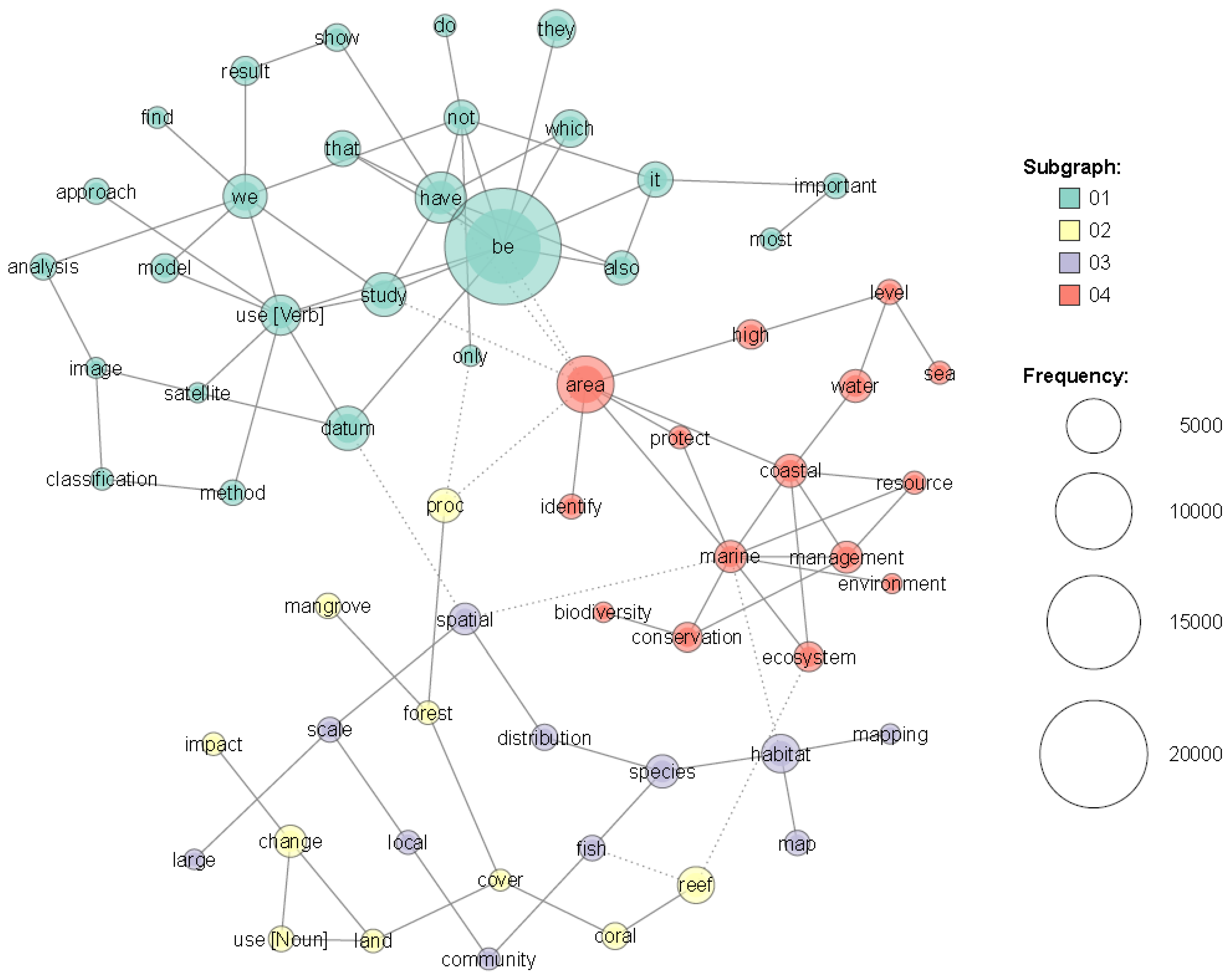
After performing the analysis, the visual expression of the results obtained by each tool was exported to pdf document format, and the resulting images were used for further analysis. The function of the Co-Occurrence Network (KH Coder, Co-Occurrence Network) allowed us to create a network diagram (Figure 1), showing the nouns, verbs, adverbs, and adjectives in the compiled database with high degrees of co-occurrence, connected by lines. It also helped us to understand the co-occurrence structures within the database, i.e., within and among different articles. The hierarchical cluster analysis of thematic words played a supportive role in eliciting and analyzing the pivotal thematic associations.
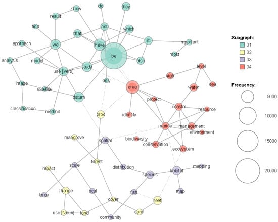
Figure 1.
A co-occurrence network of nouns, verbs, adverbs, and adjectives occurring in academic papers on the applications of RS in coastal and marine conservation.
3. Results
The visualizations of the content analysis results from the KH Coder interpretation to elicit topical co-occurrence networks for nouns, verbs, adverbs, and adjectives are given in Figure 1 (co-occurrence network). The visualizations of the essential excerpts from the elicited hierarchical clusters are given in a series of displays from Figure 2 to Figure 3. The results of the KH Coder-based content analysis displayed in the pictures are coherent between themselves and together provide a comprehensive view of main current trends and issues in applications of RS in coastal and marine conservation. The results of our survey are further compared with those achieved by Duan et al. [14].
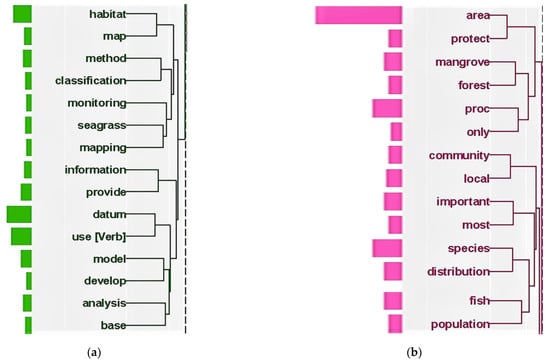
Figure 2.
Hierarchical clusters of nouns, adjectives, verbs, and adverbs occurring in academic articles on the trending theme of: (a) RS-based Classification and Modelling; (b) Conservation of Tropical Coastal and Marine Habitats, and Mapping of Habitats and Species Distribution trending themes.
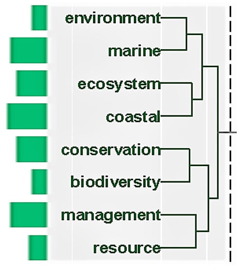
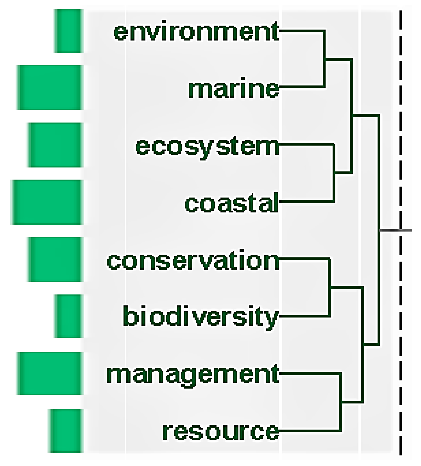
Figure 3.
Hierarchical clusters of nouns, verbs, adverbs, and adjectives occurring in academic articles on the trending themes of Ecosystem and Biodiversity Conservation and Resource Management.
3.1. RS-Based Classification and Modelling
Alongside the generic verbs, such as “be”, “have”, “study”, or “use”, and multiple vague adverbs, the largest sub-graph contains a series of suggestive and interrelated terms, such as “satellite”, “image”, “analysis”, “classification”, “method”, and “model”. It highlights the first co-occurrence sub-network, denoting a trending theme—RS-based Classification and Modelling. The articles focusing on this theme highlight different aspects of satellite imagery interpretation for various purposes—from coastal and marine habitat classification to modelling physical and biological drivers and processes. Throughout the whole database of 427 articles, the word “classification” occurs in 932 instances and the word “model” occurs in 785 instances.
The existence of this trending theme is rectified and explicated by the first excerpt of the hierarchical cluster elicited using KH Coder (Figure 2a). From that excerpt, we can see that the priority focus of the satellite imagery-based classification and modelling is on sea-grass habitats. Indeed, the word “seagrass” occurs in 1080 instances in the database, often connected to words “mapping”, “monitoring”, “classification”, and “model”. It is notable that the word “model” is closely associated with the terms “analysis” and “base”, indicating the use of RS for habitat mapping, analysis, interpretation, and modelling.
The results of our application of the KH Coder method for content analysis are very much in line with the results of the aforementioned similar previous survey by Duan et al. [14]. Their results, based on the co-occurrence analysis using the VOSviewer software, show that, since 2004, most of the research in the RS applications of PA and MPA conservation was focused on classification, time-series analysis, and model methods. The classification method held the first position with 526 articles and 11.57% of the total publications, followed by a time-series analysis (288, 6.34%) and the model method (159, 3.50%) [14].
3.2. Conservation of Tropical Coastal and Marine Habitats
The second sub-graph contains a few interrelated terms: “coral”, “reef”, “mangrove”, “forest”, “land”, “cover”, “use”, “change”, “impact”, and “proc[ent]”. It reveals the second co-occurrence sub-network, showcasing a trending theme of Conservation of Tropical Coastal and Marine Habitats. The articles focusing on this trending theme highlight different aspects of using RS for one-time assessments, regular monitoring of the fragmentation, and loss of tropical coastal and marine habitats. Throughout the database of 427 articles, the term “coral reef” occurs in 949 instances and the term “mangrove forest” occurs in 194 instances.
The existence of this trending theme is further explicated by the second excerpt of the hierarchical cluster, elicited using KH Coder (Figure 2b). From the displayed excerpt, we see that the focus is on two tropical habitats vital for the conservation of marine biodiversity—coral reefs and mangrove forests—but the term “coral reef” is not associated with any other topical word or term and remains outside of any hierarchical cluster. Hence its absence from the displayed excerpt, despite its frequent occurrence in the database. The primary conservation concern is too little acreage of “mangrove forests” under protection.
According to Duan et al. [14], “conservation” and “biodiversity” are among the most common research themes in the RS applications in PAs, including MPAs. Studies on PA monitoring using RS mainly focus on change detection, biodiversity conservation, and the impact of climate change. The main interrelated keywords are “climate change”, “change detection”, and “wetland”, which appear most frequently in the relevant research. Most keywords also relate to the use of RS to support biodiversity conservation and prevent habitat fragmentation in MPAs: alongside the most often used “remote sensing”, the other keywords include “conservation”, “biodiversity”, “protected areas”, and “fragmentation”.
3.3. Mapping of Habitats and Species Distribution
The third sub-graph also contains several closely-related nouns and adjectives: “large”, “scale”, “spatial”, “distribution”, “local”, “community”, “fish”, “species”, “habitat”, “map”, and “mapping”. It highlights the third co-occurrence sub-network, signifying a trending theme of Local Community Impact on Marine Biodiversity, which is closely related to the second co-occurrence sub-network (Figure 1). The articles focusing on this theme highlight various aspects of RS-based mapping of marine habitats and species distribution under the impact of local communities. In the database of the surveyed articles, the term “habitat map” occurs in 277 instances, ”spatial distribution” occurs in 131 instances, “fish species” occurs in 97 instances, and the term “local community” occurs in 32 instances.
The availability of this trending theme is at least partially rectified by the excerpt of the hierarchical cluster elicited using KH Coder (Figure 3). We see that the focus of this hierarchical interrelation is between the RS applications on the investigations of the spatial distribution of fish species and the local community impact on marine habitats and biodiversity. Meanwhile, in the hierarchical interrelation terms, the RS applications for habitat mapping are associated with habitat classification and monitoring (Figure 1). Hence, we note somewhat messy features and associations of the third trending theme.
Duan et al. [14] support the relative fuzziness of the third co-occurrence sub-graph and related trending theme. In their results, the co-occurrence with the highest number of keywords (12) is led by “land cover”, which is not pertinent to coastal or marine conservation. However, “land use”, “monitoring”, “mapping”, “hyperspectral”, and “classification” are also the main keywords of this cluster, indicating the association of the term “mapping” with the term “classification”. As mentioned previously, “climate change”, “change detection”, and “wetland” are essential keywords appearing in the RS applications on the habitat mapping and change detection of PAs, as well as the impact of climate change [14].
3.4. Ecosystem and Biodiversity Conservation and Resource Management
The fourth sub-graph of the co-occurrence sub-network is the most clearly articulated. It contains the most extended series of closely-related nouns, adjectives, and verbs: “coastal”, “marine”, “area”, “identify”, “protect”, “biodiversity”, “conservation”, “ecosystem”, “environment”, “resource”, “management”, “high”, “sea”, “water”, and “level”. This sub-graph denotes an overarching trending theme that we may conventionally label as Ecosystem and Biodiversity Conservation and Resource Management (Figure 1). In the surveyed articles, the term “protected area” occurs in 730 instances, “coastal area” in 234 instances, “marine protected area” in 223 instances, “biodiversity conservation” in 74 instances, “water level” in 71 instances, and the term “resource management” occurs in 47 instances.
Quite frequently occurring complex terms, along with the explicitly featured hierarchical cluster of the Ecosystem and Biodiversity Conservation and Resource Management (Figure 3), show the centrality of this trending theme. Alongside the aforementioned occurring frequency for “biodiversity conservation” and “resource management”, the term “marine environment” occurs in 196 instances and “coastal ecosystem” in 132 instances. It shows that RS as a comprehensive methodology has practical applicability for coastal and marine conservation, particularly considering the protection of MPAs and sustainable management of marine resources. It also facilitates the conservation of a wide range of coastal ecosystems, not only the tropical ones.
As already mentioned, according to Duan et al. [14], “conservation” and “biodiversity” are among the most common research topics on RS applications for PAs, including MPAs. One of the co-occurrence clusters in their study has 10 keywords: alongside the most frequently used “remote sensing”, the other keywords include “conservation”, “biodiversity”, “protected areas”, and “fragmentation”. Most keywords in this cluster relate to the use of RS to support biodiversity conservation in PAs. Duan et al. argue that the development of RS platforms and sensors will deliver crucial support for the monitoring of PAs and marine resource management [14].
Summing up, the articles focusing on RS-based Classification and Modelling highlight different aspects of satellite imagery interpretation for coastal and marine habitat classification to time-series analysis and modelling physical and biological processes and drivers. It is coherent with the survey results by Duan et al. [14]. The trending deliberation is on using RS for one-time assessments and monitoring to prevent habitat fragmentation and support biodiversity conservation in MPAs. The next essential result is the priority focus on the interrelations between the RS applications to survey the spatial distribution of fish species and the local community impact on marine habitats and biodiversity. Ecosystem and biodiversity conservation and resource management are clearly articulated trending themes.
4. Discussion
Content analysis of the selected 427 articles has revealed a few perspective avenues for future research in RS applications for coastal and marine nature conservation. First, this field’s progress depends on developing new technologies and platforms for monitoring (including low-cost UAVs) and interpreting coastal and marine use changes on the small-scale ecosystem and habitat level in response to anthropogenic and natural pressures and drivers. Particularly improvements in the spectral, spatial, and temporal resolution of RS platforms are instrumental in filling gaps in mapping marine habitat and ecosystem diversity and services [22].
Small and sensitive marine areas with critical ecological values can take particular advantage of the use of high-quality UAV sensors for observing and quantifying a wide range of ecosystem processes, biodiversity metrics, and natural and anthropogenic stressors to be measured at a high level of detail or derived from collected data [22,23]. Furthermore, as 3D imaging is being coupled with dedicated deep-learning architectures to create a new cutting-edge standard for creative problem-solving in endangered seabed habitat detection, classification, and mapping, new technologies may provide an opportunity for facilitating cheaper image and video data collection techniques and analysis at high resolution in real-time [22,23,24,25].
Another challenge is the development and application of object-based analysis approaches [22] for mapping and interpreting the seabed cover and use changes in terms of natural capital flow [26], as well as coastal, estuarine, and marine ecosystem services (ES) [27,28]. In this way, the augmenting of spatiotemporal RS imagery may deliver the ability to join databases to strengthen mapping protocols and online processing capability, such as with Google Earth Engine [22]. It also helps identify the resources at risk and the forces that drive the risk [26], assess the cumulative impacts of all human activities and natural disturbances, and deliver forecasts informing future development [29].
The use of ‘citizen science’ as a source of information to complement the RS data on coastal and marine conservation (e.g., open-source databases and information provided by MPA managers, local fishermen, or divers) is a new and rapidly developing academic field. It contributes to the mapping of marine and coastal habitats and ecosystem services and, hence, the provision of the evidence base that underpins marine conservation policy. In addition, local stakeholders are also a source of valuable in situ knowledge pivotal for developing regional knowledge that can be used for MPA conservation and management purposes [22,30,31,32,33,34,35,36,37].
The information generated by littoral ‘citizen science’ networks and stakeholders and gained using innovative tools, such crowdsourcing with smartphone apps or content analysis of geo-tagged photographs from freely accessible photo-sharing platforms and analyzed semi-automatically [22], can be of sufficient quality to fill the gaps of reliable time-series data requirement, create the baseline maps, and gauge the effectiveness of MPA management plans if it is collected in a standardized way, along with information cross-checking and validation using social research methods, such as suitably designed questionnaires, socioeconomic surveys, Delphi technique, and focus groups [31,35,36,37,38].
The data garnered from ‘citizen science’ contributors may not be as reliable as scientific data: visual observations can be limited, especially if related to the subaquatic environment. Without rigid sampling and data collection guidelines, the validity of spatial information on the endangered marine habitats delivered by MPA managers and other coastal and marine stakeholders will have limited value [31,34]. On the other hand, it is fully appropriate that not all citizen science contributions deliver policy-relevant evidence because there may be other motivations for citizen science programmes (e.g., education, enjoying the marine environment, combating coastal and marine litter) [32].
The methodological design for collecting ‘citizen data’ for purposes of long-term marine monitoring would likely require adjustments to ensure the comparability of data over time to mitigate a “shifting baselines syndrome”, where the lack of documented baseline knowledge permits a slide in the scale of baseline assessments of human impact by the MPA managers [29,31,34]. The gap between MPA managers’ perception and objective RS imagery comes from an absence of a reference situation for the habitats and their robustness, which makes any inter-temporal comparison difficult [31].
Therefore, as mentioned, there is a need for strict accuracy testing and firm reference baselines for the maps generated with contributions from ‘citizen science’ across a variety of habitats, since a false judgment about habitat change can lead to a disproportional management response [22,31,36]. As noted by Failler et al. [31], the validity of information on the marine habitats delivered by MPA managers and other coastal and marine stakeholders must be scrutinized during work on the establishment of stocktaking procedures, baseline situation assessment, research on habitat changes, inter alia, especially with so-called Rapid Appraisal Approaches.
The hybrid baseline maps generated with contributions from ‘citizen science’ and RS can be integrated with the aim of monitoring a wide array of parameters [36]. In this way, improved RS techniques, coupled with conventional on-site monitoring methods and ‘citizen science’ input, may help close a few gaps in MPA monitoring [39]. Therefore, a hybrid approach in participatory remote sensing is a relevant methodology, and it will reinforce coastal and marine research and MPA management as it facilitates bridging a gap between scientists and local communities and encourages the management of coastal and marine ecosystems in a sustainable way [40,41].
As a result, this hybrid approach should secure ground-truthing and field verification as to whether there are indeed outstanding ecological and biological values in MPAs by a multidisciplinary research team. It should include an RS expert to ensure applying RS-based technological advances and appropriate spatiotemporal resolution [23,27,31,39]. It may also resolve operational and analytical shortcomings that undermine the future RS applications in MPAs. On the other hand, measurable goals adequate for the hybrid approach are essential to monitor the progress in MPA conservation. Therefore, the pivotal direction in setting goals for the MPA conservation that are site-specific is to enhance the hybridization of the monitoring system [42].
5. Conclusions
The main conclusion is that the overarching trending theme is the use of the satellite imagery-based habitat mapping, classification, analysis, interpretation, and modelling of habitats vital for the conservation of marine biodiversity—coral reefs, mangrove forests, and sea-grass meadows. Studies on MPA monitoring using RS mainly focus on change detection, biodiversity conservation, and the impact of climate change. This theme is closely related to the trending theme of local community impact on marine biodiversity. Hence, satellite RS as a comprehensive methodology has practical applicability for MPA conservation, especially with ‘citizen science’ data. RS also facilitates the conservation of a wide range of coastal ecosystems, not only the tropical ecosystems.
Thinking ‘glocally’ (globally and locally simultaneously), RS technology in a hybrid framework provides marine conservation decision-makers with a knowledge informing and prioritizing potential management actions while offering an opportunity for all countries and humans, even those that cannot access pivotal data, to be part of a local solution for global problems [43,44]. More specifically, considering the situation in the EU, a critical aspect is data regarding the MSFD descriptors for applications of RS to monitor the environmental status of marine waters and to assess anthropogenic pressures [26].
If an MPA or a maritime spatial planning (MSP) area includes different polities and administrations, legal barriers must be identified and proper measures must be undertaken in order to regard the physical and ecological connectivity within the area, which requires an adequate spatiotemporal RS-based marine habitat monitoring and management system [45]. A generalization of the hybrid approaches to monitor, classify, and map coastal and marine environments worldwide should, therefore, [46] (p. 17):
- Bring common references;
- Frame objectively scores per MSP area and between areas;
- Identify conservation gaps;
- Help inferring quantitative conservation recommendations and relevant policies for the 2020s.
We must review the merits and liabilities of MPA monitoring and conservation approaches, delineate the application of RS techniques, and accentuate the most urgent conservation targets [47]. Data about these targets for many MPAs should be made usable by overcoming the problem of spatial assessment and applying modelled forecasts [48]. For example, one critical MPA monitoring and conservation issue is that most offshore areas lack high-precision information. This gap can be eliminated with advanced RS methods [49]. Additionally, considering ecosystem-level data should deliver a more detailed assessment of the strengths and gaps in current and proposed MPAs [50,51].
Apparent challenges exist for monitoring, classification, and mapping of some seabed habitats, even in the Baltic Sea, which, we argue, has one of the most advanced and comprehensive MPA systems in the world, and habitat vulnerability is a crucial factor to take into consideration for the future hybrid applications of RS with ‘citizen science’. For this reason, future research in this field should focus on science-based added-value products, extending them into downstream societal services, which will contribute to the UN 2030 Agenda and, more specifically, focus on achieving an SDG14 indicator of 10% marine habitat conservation by bridging the science and policy gap.
Author Contributions
Conceptualization, E.J. and R.P.; methodology, E.J.; software, E.J.; validation, A.R.-B., R.P. and J.T.; formal analysis, E.J.; investigation, E.J.; resources, J.T.; data curation, J.T.; writing—original draft preparation, E.J.; writing—review and editing, R.P.; visualization, E.J.; supervision, A.R.-B.; project administration, J.T. All authors have read and agreed to the published version of the manuscript.
Funding
This research received no external funding.
Data Availability Statement
Not applicable.
Acknowledgments
We appreciate the insightful and constructive comments and suggestions from the anonymous reviewers that helped improve the quality and presentation of the manuscript.
Conflicts of Interest
The authors declare no conflict of interest.
References
- Povilanskas, R.; Armaitienė, A.; Breber, P.; Razinkovas-Baziukas, A.; Taminskas, J. Integrity of linear littoral habitats of Lesina and Curonian Lagoons. Hydrobiologia 2012, 699, 99–110. [Google Scholar] [CrossRef]
- Kavanaugh, M.T.; Bell, T.; Catlett, D.; Cimino, M.A.; Doney, S.C.; Klajbor, W.; Messié, M.; Montes, E.; Muller-Karger, F.E.; Otis, D.; et al. Satellite Remote Sensing and the Marine Biodiversity Observation Network. Oceanography 2021, 34, 62–79. [Google Scholar] [CrossRef]
- Topouzelis, K.; Papakonstantinou, A.; Singha, S.; Li, X.; Poursanidis, D. Editorial on Special Issue “Applications of Remote Sensing in Coastal Areas”. Remote Sens. 2020, 12, 974. [Google Scholar] [CrossRef] [Green Version]
- Wang, Y.; Lu, Z.; Sheng, Y.; Zhou, Y. Remote sensing applications in monitoring of protected areas. Remote Sens. 2020, 12, 1370. [Google Scholar] [CrossRef]
- El Mahrad, B.; Newton, A.; Icely, J.D.; Kacimi, I.; Abalansa, S.; Snoussi, M. Contribution of remote sensing technologies to a holistic coastal and marine environmental management framework: A review. Remote Sens. 2020, 12, 2313. [Google Scholar] [CrossRef]
- Karnauskaitė, D.; Schernewski, G.; Schumacher, J.; Grunert, R.; Povilanskas, R. Assessing coastal management case studies around Europe using an indicator-based tool. J. Coast. Conserv. 2018, 22, 549–570. [Google Scholar] [CrossRef] [Green Version]
- Kelleher, G. Guidelines for Marine Protected Areas; IUCN: Gland, Switzerland; Cambridge, UK, 1999; ISBN 2831705053. [Google Scholar]
- Wang, Y. Remote Sensing of Protected Lands: An Overview. In Remote Sensing of Protected Lands; Wang, Y., Ed.; Taylor and Francis Group: New York, NY, USA, 2012; pp. 1–25. [Google Scholar]
- Kachelreiss, D.; Wegmann, M.; Gollock, M.; Pettorelli, N. The application of remote sensing for marine protected area management. Ecol. Indic. 2014, 36, 169–177. [Google Scholar] [CrossRef]
- Jonsson, P.R.; Moksnes, P.O.; Corell, H.; Bonsdorff, E.; Nilsson Jacobi, M. Ecological coherence of Marine Protected Areas: New tools applied to the Baltic Sea network. Aquat. Conserv. Mar. Freshw. Ecosyst. 2020, 30, 743–760. [Google Scholar] [CrossRef] [Green Version]
- Baltranaitė, E.; Povilanskas, R.; Dučinskas, K.; Ernšteins, R.; Tõnisson, H. Systems Approach to Eastern Baltic Coastal Zone Management. Water 2020, 12, 3102. [Google Scholar] [CrossRef]
- Jurkus, E.; Taminskas, J.; Povilanskas, R.; Kontautienė, V.; Baltranaitė, E.; Dailidė, R.; Urbis, A. Delivering tourism sustainability and competitiveness in seaside and marine resorts with GIS. J. Mar. Sci. Eng. 2021, 9, 312. [Google Scholar] [CrossRef]
- Da Silveira, C.B.L.; Strenzel, G.M.R.; Maida, M.; Gaspar, A.L.B.; Ferreira, B.P. Coral Reef Mapping with Remote Sensing and Machine Learning: A Nurture and Nature Analysis in Marine Protected Areas. Remote Sens. 2021, 13, 2907. [Google Scholar] [CrossRef]
- Duan, P.; Wang, Y.; Yin, P. Remote sensing applications in monitoring of protected areas: A bibliometric analysis. Remote Sens. 2020, 12, 772. [Google Scholar] [CrossRef] [Green Version]
- Wang, Y. Coastal Environments: Remote Sensing. In Coastal and Marine Environments; Wang, Y., Ed.; Taylor and Francis Group: New York, NY, USA, 2020; pp. 267–276. [Google Scholar]
- Orusa, T.; Borgogno Mondino, E. Exploring Short-term climate change effects on rangelands and broad-leaved forests by free satellite data in Aosta Valley (Northwest Italy). Climate 2021, 9, 47. [Google Scholar] [CrossRef]
- Baltranaitė, E.; Jurkus, E.; Povilanskas, R. Impact of physical geographical factors on sustainable planning of South Baltic seaside resorts. Baltica 2018, 30, 119–131. [Google Scholar] [CrossRef]
- Bowen, G.A. Document Analysis as a Qualitative Research Method. Qual. Res. J. 2009, 9, 27–40. [Google Scholar] [CrossRef] [Green Version]
- KH Coder 3.0. Available online: https://khcoder.net/en/ (accessed on 20 July 2021).
- Nattuthurai, P.; Aryal, A. Content Analysis of Dark Net Academic Journals from 2010–2017 Using KH Coder. ACET J. Comput. Educ. Res. 2018, 12, 25–35. [Google Scholar]
- Ylijoki, O.; Porras, J. Conceptualizing big data: Analysis of case studies. Intell. Syst. Account. Fin. Manag. 2016, 23, 295–310. [Google Scholar] [CrossRef]
- McKenzie, L.J.; Nordlund, L.M.; Jones, B.L.; Cullen-Unsworth, L.C.; Roelfsema, C.; Unsworth, R.K. The global distribution of seagrass meadows. Environ. Res. Lett. 2020, 15, 074041. [Google Scholar] [CrossRef]
- Jiménez López, J.; Mulero-Pázmány, M. Drones for conservation in protected areas: Present and future. Drones 2019, 3, 10. [Google Scholar] [CrossRef] [Green Version]
- Moniruzzaman, M.; Islam, S.M.; Lavery, P.; Bennamoun, M.; Lam, C.P. Imaging and classification techniques for seagrass mapping and monitoring: A comprehensive survey. arXiv 2019, arXiv:1902.11114. [Google Scholar]
- Costello, M.J.; Darnaedi, D.; Diway, B.; Ganyai, T.; Grudpan, C.; Hughes, A.; Ishii, R.; Lim, P.T.; Ma, K.; Muslim, A.M.; et al. The Asia-Pacific Biodiversity Observation Network: 10-year achievements and new strategies to 2030. Ecol. Res. 2021, 36, 232–257. [Google Scholar]
- Aretano, R.; Parlagreco, L.; Semeraro, T.; Zurlini, G.; Petrosillo, I. Coastal dynamics vs beach users attitudes and perceptions to enhance environmental conservation and management effectiveness. Mar. Poll. Bul. 2017, 123, 142–155. [Google Scholar] [CrossRef] [PubMed]
- Hossain, M.S.; Hashim, M. Potential of Earth Observation (EO) technologies for seagrass ecosystem service assessments. Int. J. Appl. Earth Observ. Geoinf. 2019, 77, 15–29. [Google Scholar] [CrossRef]
- Tagliapietra, D.; Povilanskas, R.; Razinkovas-Baziukas, A.; Taminskas, J. Emerald Growth: A New Framework Concept for Managing Ecological Quality and Ecosystem Services of Transitional Waters. Water 2020, 12, 894. [Google Scholar] [CrossRef] [Green Version]
- Lieske, D.J.; Tranquilla, L.M.; Ronconi, R.A.; Abbott, S. “Seas of risk”: Assessing the threats to colonial-nesting seabirds in Eastern Canada. Mar. Policy 2020, 115, 103863. [Google Scholar] [CrossRef]
- Caro, C.; Pinto, R.; Marques, J.C. Use and usefulness of open-source spatial databases for the assessment and management of European coastal and marine ecosystem services. Ecol. Indic. 2018, 95, 41–52. [Google Scholar] [CrossRef]
- Failler, P.; Touron-Gardic, G.; Sadio, O.; Traoré, M.S. Perception of natural habitat changes of West African marine protected areas. Ocean Coast. Manag. 2020, 187, 105120. [Google Scholar] [CrossRef]
- Hyder, K.; Townhill, B.; Anderson, L.G.; Delany, J.; Pinnegar, J.K. Can citizen science contribute to the evidence-base that underpins marine policy? Mar. Policy 2015, 59, 112–120. [Google Scholar] [CrossRef]
- Kockel, A.; Ban, N.C.; Costa, M.; Dearden, P. Addressing distribution equity in spatial conservation prioritization for small-scale fisheries. PLoS ONE 2020, 15, e0233339. [Google Scholar] [CrossRef]
- Loerzel, J.L.; Goedeke, T.L.; Dillard, M.K.; Brown, G. SCUBA divers above the waterline: Using participatory mapping of coral reef conditions to inform reef management. Mar. Policy 2017, 76, 79–89. [Google Scholar] [CrossRef]
- Singh, A.A.; Maharaj, A.; Kumar, M.; Singh, P.; Singh, S.; Muller-Karger, F.E.; McCarthy, M.; Joseph, L.; Damlamian, H.; Begg, Z. Developing high resolution baseline coast resource maps using world view 2 imagery for a coastal village in Fiji. Front. Mar. Sci. 2019, 6, 207. [Google Scholar] [CrossRef]
- Singh, A.A.; Maharaj, A.; Singh, P. Benthic Resource Baseline Mapping of Cakaunisasi and Yarawa Reef Ecosystem in the Ba Region of Fiji. Water 2021, 13, 468. [Google Scholar] [CrossRef]
- Tintoré, J.; Pinardi, N.; Álvarez-Fanjul, E.; Aguiar, E.; Álvarez-Berastegui, D.; Bajo, M.; Balbin, R.; Bozzano, R.; Nardelli, B.B.; Cardin, V.; et al. Challenges for sustained observing and forecasting systems in the Mediterranean Sea. Front. Mar. Sci. 2019, 6, 568. [Google Scholar] [CrossRef] [Green Version]
- Urbis, A.; Povilanskas, R.; Šimanauskienė, R.; Taminskas, J. Key aesthetic appeal concepts of coastal dunes and forests on the example of the Curonian Spit (Lithuania). Water 2019, 11, 1193. [Google Scholar] [CrossRef] [Green Version]
- Visalli, M.E.; Best, B.D.; Cabral, R.B.; Cheung, W.W.L.; Clark, N.A.; Garilao, C.; Kaschner, K.; Kesner-Reyes, K.; Lam, V.W.Y.; Maxwell, S.M.; et al. Data-driven approach for highlighting priority areas for protection in marine areas beyond national jurisdiction. Mar. Policy 2020, 122, 103927. [Google Scholar] [CrossRef]
- Azhar, A.; Damar, A.; Bengen, D.G.; Atmadipoera, A.S. Shallow water marine habitat mapping of Kaledupa Island using integrating traditional ecological knowledge and multispectral image classification. IOP Conf. Ser. Earth Environ. Sci. 2019, 241, 012038. [Google Scholar] [CrossRef] [Green Version]
- Papakonstantinou, A.; Batsaris, M.; Spondylidis, S.; Topouzelis, K. A Citizen Science Unmanned Aerial System Data Acquisition Protocol and Deep Learning Techniques for the Automatic Detection and Mapping of Marine Litter Concentrations in the Coastal Zone. Drones 2021, 5, 6. [Google Scholar] [CrossRef]
- Lee, W.H.; Abdullah, S.A. Framework to develop a consolidated index model to evaluate the conservation effectiveness of protected areas. Ecol. Indic. 2019, 102, 131–144. [Google Scholar] [CrossRef]
- Kansakar, P.; Hossain, F. A review of applications of satellite earth observation data for global societal benefit and stewardship of planet earth. Space Policy 2016, 36, 46–54. [Google Scholar] [CrossRef]
- McLeod, E.; Shaver, E.C.; Beger, M.; Koss, J.; Grimsditch, G. Using resilience assessments to inform the management and conservation of coral reef ecosystems. J. Environ. Manag. 2021, 277, 111384. [Google Scholar] [CrossRef]
- Muñoz, M.; Reul, A.; Plaza, F.; Gómez-Moreno, M.L.; Vargas-Yañez, M.; Rodríguez, V.; Rodríguez, J. Implication of regionalization and connectivity analysis for marine spatial planning and coastal management in the Gulf of Cadiz and Alboran Sea. Ocean Coast. Manag. 2015, 118, 60–74. [Google Scholar] [CrossRef]
- Gairin, E.; Andréfouët, S. Role of habitat definition on Aichi Target 11: Examples from New Caledonian coral reefs. Mar. Policy 2020, 116, 103951. [Google Scholar] [CrossRef]
- Nelms, S.E.; Alfaro-Shigueto, J.; Arnould, J.P.Y.; Avila, I.C.; Bengtson Nash, S.; Campbell, E.; Carter, M.I.D.; Collins, T.; Currey, R.J.C.; Domit, C.; et al. Marine mammal conservation: Over the horizon. Endanger. Species Res. 2021, 44, 291–325. [Google Scholar] [CrossRef]
- Yamakita, T.; Sudo, K.; Jintsu-Uchifune, Y.; Yamamoto, H.; Shirayama, Y. Identification of important marine areas using ecologically or biologically significant areas (EBSAs) criteria in the East to Southeast Asia region and comparison with existing registered areas for the purpose of conservation. Mar. Policy 2017, 81, 273–284. [Google Scholar] [CrossRef]
- Majidi Nezhad, M.; Shaik, R.U.; Heydari, A.; Razmjoo, A.; Arslan, N.; Astiaso Garcia, D. A SWOT analysis for offshore wind energy assessment using remote-sensing potential. Appl. Sci. 2020, 10, 6398. [Google Scholar] [CrossRef]
- Brooks, C.M.; Chown, S.L.; Douglass, L.L.; Raymond, B.P.; Shaw, J.D.; Sylvester, Z.T.; Torrens, C.L. Progress towards a representative network of Southern Ocean protected areas. PLoS ONE 2020, 15, e0231361. [Google Scholar] [CrossRef] [PubMed] [Green Version]
- Reddy, C.S.; Faseela, V.S.; Unnikrishnan, A.; Jha, C.S. Earth observation data for assessing biodiversity conservation priorities in South Asia. Biodivers. Conserv. 2019, 28, 2197–2219. [Google Scholar] [CrossRef]

Publisher’s Note: MDPI stays neutral with regard to jurisdictional claims in published maps and institutional affiliations. |
© 2022 by the authors. Licensee MDPI, Basel, Switzerland. This article is an open access article distributed under the terms and conditions of the Creative Commons Attribution (CC BY) license (https://creativecommons.org/licenses/by/4.0/).