1. Introduction
The accelerated expansion of urbanized settlements requires effective strategies to ensure public safety and environmental health by effectively managing stormwater [
1]. The expanding reliance on efficient stormwater drainage requires an increasing understanding of urban drainage systems to evolve from a grey infrastructure-only approach toward an alternative one that complements grey infrastructure with blue and green infrastructure. The implementation of blue and green infrastructure in urban areas is carried out through sustainable urban drainage systems (SUDS), which have been proven to support the reduction of flood risks and increase resilience against extreme rainfall events [
2]. However, despite the proven benefits of SUDS interacting with existing grey infrastructure and reducing impermeability of urban settlements, mainstreaming these practices remains slow due to scientific and sociopolitical uncertainties and socio-institutional barriers. To reduce such uncertainties, a quantification of the effects of applying techniques to reduce the impermeabilization of the landscape is required to support decision-making processes.
This study will explore the effects of reducing impermeability on the risk of failure of a pluvial drainage system and will be applied in a case study.
2. Materials and Methods
2.1. Case Study
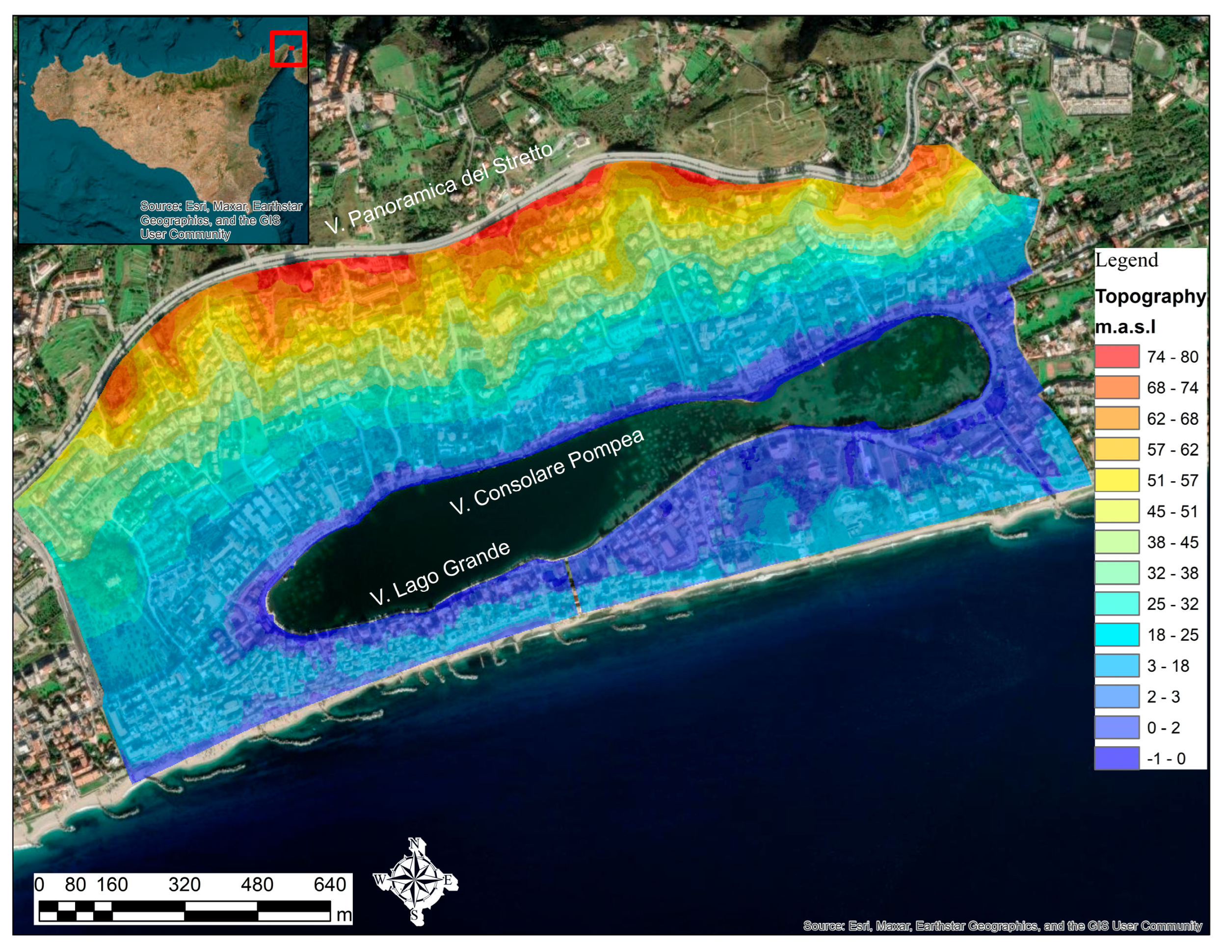
The case study is Lake Ganzirri and its surrounding neighborhoods, located in Messina, on the northeastern tip of Sicily in Italy (
Figure 1). The lake is surrounded by extensive coastal lowlands, sea dunes, and expanding human habitation.
Historically, rainwater could drain directly into the lake, but in 2001, the lake and surroundings have fallen within the Oriented Nature Reserve; consequently, the outlets were closed to safeguard the lake’s ecosystem, leaving main roads more vulnerable to pluvial floods with no functional pluvial drainage system. The Ganzirri case study presents many urban water issues common in urbanized settlements. However, this area does not have a functional drainage system. Therefore, for the implementation of the methodology, a pluvial drainage network was designed for the real conditions of the case study using a design rainfall event with a 10-year return period and used for the study simulations. The study area’s percentage of impermeable area is 70%, and the design parameters were that all pipes should have a max/full depth less than 90% and speeds not exceeding 6 m/s.
2.2. Methodology
This study aims to quantify the effect of changes in the impermeable area in urbanized settlements on the risk of failure of a pluvial drainage network designed for the study area. The rainfall input was derived using a three-parameter depth-duration-frequency (DDF) following the regional methodology proposed by Bonaccorso et al. [
3], and the Chicago hyetograph method was applied to compute 3 h unimodal design rainfall for 5-, 10-, 20-, and 30-year return periods.
We define risk of failure (RN) as the compound probability that a given design rainfall event with a return period of T-years (TD) will be equal to or surpassed during the network’s N-year life span, which translates to the network’s possible failure due to the excess of rainfall for which it was designed in the first place.
The results explore the effect on the risk of failure (RN) of changes in the percentage of impermeable area in an urban settlement. In particular, the work was conducted in the following four stages:
Stage I: Infoworks ICM was implemented and run with several rainfall events with different return periods as inputs. Data input includes digital layouts of Lake Ganzirri and its surroundings, layers of buildings, roads, and open green areas and a digital elevation model at 2 × 2 m resolution. The percentage of impermeable area was changed, creating more permeable and impermeable scenarios than the real case. The permeable areas were taken as areas with live bush and trees (n-Manning = 0.06 m1/3/s), and the infiltration method applied was the simple runoff coefficient.
Stage II: The models’ outputs were organized to configure the max/full depth as a function of the percentage of impermeable area.
Stage III: The simulations’ max/full depth results were analyzed to identify what percentage of impermeable area causes at least one link to surpass a given threshold (0.7, 0.8, and 0.9). The results are displayed in curves revealing the study area’s response if the impermeable area is changed (i.e., applying LID/SUDS strategies) for different rainfall events. At this stage, an iterative process repeats Stages I, II, and III with different drainage system design rainfalls.
Stage IV: With all results, this stage explores the relationship between the percentage of the minimum impermeable area that ensures the pluvial drainage system functions without risk of pressurization of the links and the value of the risk of failure associated with a design rainfall.
3. Results and Discussion
The study area was divided into 10 urban sub-catchments that drain directly toward the main road (Via Consolare Pompea, which connects to Via Lago Grande). Due to the high slope and the growth in housing projects in the area, the study focused on the residential area developed on the northern side of the lake, which impermeabilized the landscape.
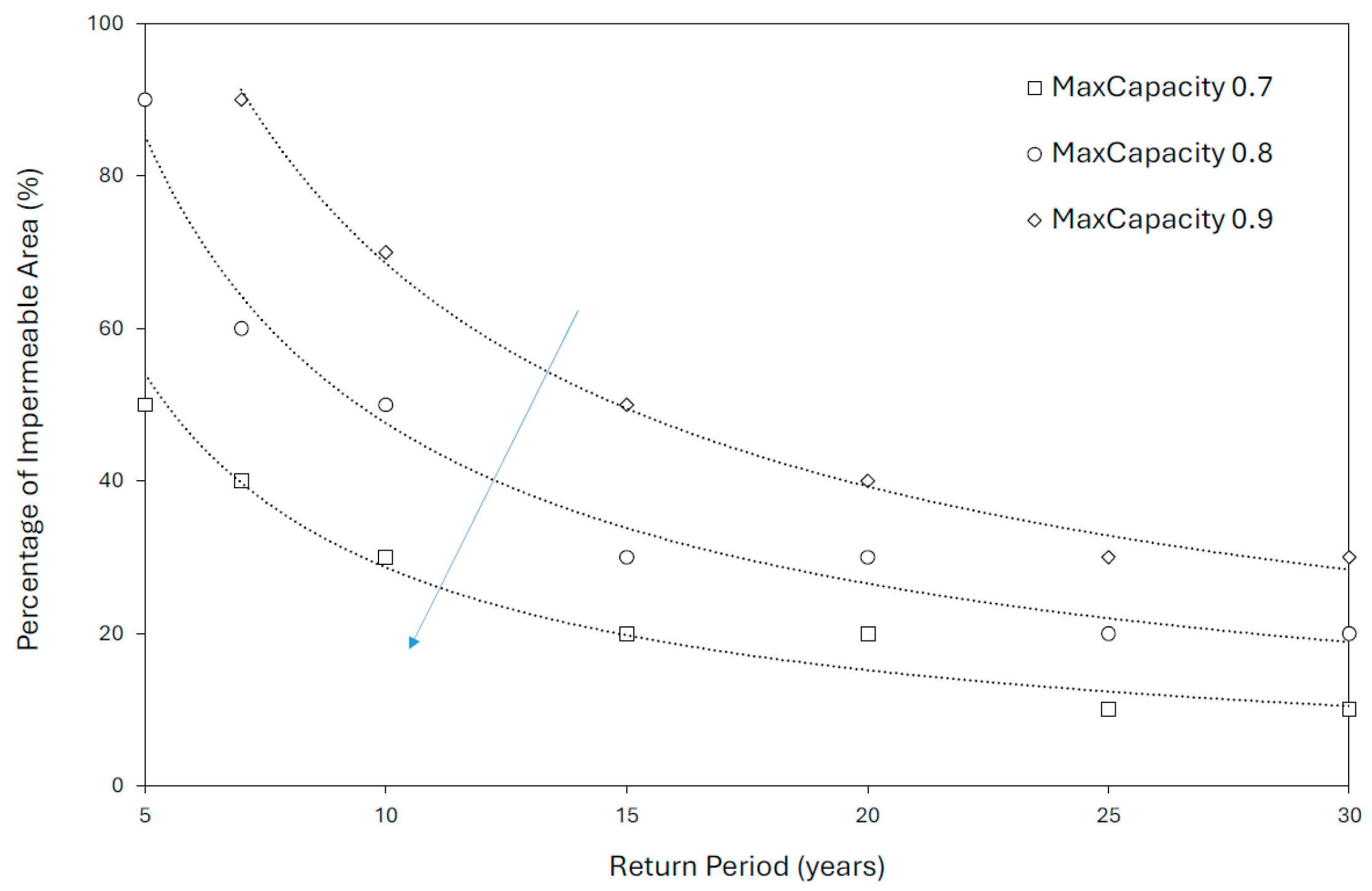
The relationship between the percentage of impermeable area (Ai) that causes at least one link of the pluvial network to surpass a given max/full depth and the return period in years of the rainfall event (T) can be expressed as a two-parameter potential relationship.
Figure 2 displays the relationship between the percentage of impermeable area vs. rainfall return period.
For instance, the methodology presented in this study, applied to the case study of Lake Ganzirri, reveals that the designed pluvial drainage network would require a reduction of impermeable area from 70% to 50% to ensure all links of the network function with a max/full depth less than 80%, a scenario with less risk of pluvial flood triggered by pressurization of links and node collapse than the original design. Additionally, when considering more intense rainfall events, such as a 30-year return period, the same pluvial drainage system will work safely if the impermeable area changes from 70% to 30%.
Regarding risk of failure, this study found that for a design rainfall event with a 10-year return period and a 20-year pluvial drainage network, there is a probability of 88% that the designed rainfall (from which the pipes were dimensioned) will be equalled or surpassed during the system’s life span. Additionally, the risk of failure of 88% is associated with a system functioning with all the pipes with max/full depth values less than 0.9. Generally, the return period for the rainfall design is adjusted in function of the risk of failure the designer is willing to assume, resulting in bigger diameters. However, a reduction of a permeable area can also translate into lesser values of full/max depth without increasing the diameters.
Author Contributions
Conceptualization, J.J.S.C., G.B. and G.T.A.; Data curation and formal analysis, J.J.S.C.; Funding acquisition, G.B. and G.T.A.; Investigation, J.J.S.C. and G.B.; Methodology, J.J.S.C.; Project administration, G.B. and G.T.A.; Resources and supervision, G.T.A.; Validation, G.B. and G.T.A.; Visualization, J.J.S.C.; Writing—original draft, J.J.S.C. and G.B.; Writing—review and editing, J.J.S.C., G.B. and G.T.A. All authors have read and agreed to the published version of the manuscript.
Funding
This work was developed under the PRIN 2020 (Research Projects of National Interest) project titled “Floods in cities: New INSights for integrating Pluvial floodIng into flood Risk maNaGement plans (INSPRING)” financed by the Italian Ministry for Universities and Research (MIUR) and under the PNRR B.A.C. project “Multi-Risk sciEnce for resilienT commUnities undeR a changiNg climate” (RETURN)—SPOKE 5 titled “Sustainable Urban areas by Nature-based solutions implementation to mitigate climate impacts and achieve a Resilient, Innovative and Smart Environment” (SUNRISE) Grant Number: 2020NTSFXF.
Institutional Review Board Statement
Not applicable.
Informed Consent Statement
Not applicable.
Data Availability Statement
The raw data supporting the conclusions of this article will be made available by the authors on request.
Acknowledgments
This article was produced while attending the PhD programme in PhD in Sustainable Development And Climate Change at the University School for Advanced Studies IUSS Pavia, Cycle XXXIX, with the support of a scholarship co-financed by the Ministerial Decree no. 352 of 9th April 2022, based on the NRRP—funded by the European Union—NextGenerationEU—Mission 4 “Education and research”, Component 2 “From Research to Business”, Investment 3.3, and by the company GetOpen Srl. During the preparation of this manuscript, the author(s) used Grammarly Pro v1.2.262.1891 for the purposes of proofreading. The authors have reviewed and edited the output and take full responsibility for the content of this publication.
Conflicts of Interest
The authors declare no conflicts of interest. The funders had no role in the design of the study; in the collection, analyses, or interpretation of data; in the writing of the manuscript; or in the decision to publish the results.
References
- Chen, X.; Fang, Z.; Liu, J.; Chai, Y.; Yu, H.; Zhou, H.; Gao, Y. Mitigation Effects of Integrated Green-Grey-Blue-Control Systems on Urban Flooding in Plain Regions. Water Resour. Manag. 2025, 39, 5313–5338. [Google Scholar] [CrossRef]
- Rosenzweig, B.R.; McPhillips, L.; Chang, H.; Cheng, C.; Welty, C.; Matsler, M.; Iwaniec, D.; Davidson, C.I. Pluvial Flood Risk and Opportunities for Resilience. WIREs Water 2018, 5, e1302. [Google Scholar] [CrossRef]
- Bonaccorso, B.; Brigandì, G.; Aronica, G.T. Regional Sub-Hourly Extreme Rainfall Estimates in Sicily under a Scale Invariance Framework. Water Resour. Manag. 2020, 34, 4363–4380. [Google Scholar] [CrossRef]
| Disclaimer/Publisher’s Note: The statements, opinions and data contained in all publications are solely those of the individual author(s) and contributor(s) and not of MDPI and/or the editor(s). MDPI and/or the editor(s) disclaim responsibility for any injury to people or property resulting from any ideas, methods, instructions or products referred to in the content. |