


Abstract
Current flood early warning and risk communication approaches are often characterized by simple and/or alarmist messages, which can promote non-protective behaviours—either through overreliance on defence structures or emergency management organizations. In response, we propose and develop an early warning system (EWS) prototype aimed at fostering “flood literacy” within communities. This system seeks to empower individuals and local populations to better understand their flood risk by recognizing their personal vulnerability and the characteristics of potential floods affecting them. Such understanding enables timely and appropriate self-protective actions. The proposed EWS comprises an Internet of Things (IoT)-based camera network for monitoring rainfall, water depth, and water velocity based on Artificial Intelligence (AI) techniques. These AI algorithms have been used also to analyze and assess historical flood events in the study area, i.e., the heritage city of Matera (Basilicata Region, Italy). The monitoring system is integrated with AI-driven flood modelling to generate impact scenarios at the local scale. These forecasted scenarios can be compared with historical flood data to contextualize current measurements of rainfall and water levels and therefore the citizens can judge how significant a flood might be. The system incorporates threshold-based alerts related to flood instability for pedestrians, along with signals and symbols designed for quick interpretation and communication of self-protection measures to improve citizen resilience and response.
1. Introduction
Urban flash floods due to extreme rainfall events are one of the most frequent, dangerous, and destructive natural threats leading to casualties and serious economic losses [1]. This was seen in the southern heritage city of Matera, Italy, renowned for its ancient cave dwellings and designated as the European Capital of Culture in 2019, which recently faced severe flash floods in 2013, 2018, 2019, 2023, and 2024 [2]. Therefore, this city urgently needs an effective citizen-oriented early warning system (EWS) for flood risk adaptation. Most of the currently developed EWSs are computationally expensive, less effective, and fail to meet user needs for information in the period before a flood event, leaving users unsure of what will happen, or how best to respond [3]. Therefore, this research proposes an effective EWS prototype to foster “flood literacy” within communities. In this research, we integrate IoT (Internet of Thing) and Artificial Intelligence (AI) techniques, AI-based flood modelling, and a risk communication alert system for the development of an innovative EWS approach that can empower the communities and individuals to develop their knowledge of pluvial flood risk at a local level. The system aims to make citizens able to take responsibility for effectively monitoring flood risk (e.g., through rainfall, water depth and flow velocity monitoring via an IoT camera network) and to use simulated flood scenarios and data on past events to assess how significant a flood might be. Additionally, the flood mapping system can support the detailed understanding of how floods could occur based on knowledge of the dynamics of expected or ongoing events, and to relate these to potential impacts in terms of pedestrian instability thresholds. The proposed approach allows individuals to judge what actions to take in response and when to act, thanks also to a developed system of self-protection measures involving symbols, signals and videos that show the suitable and inappropriate behaviours before, during and after a flood.
2. Methodology
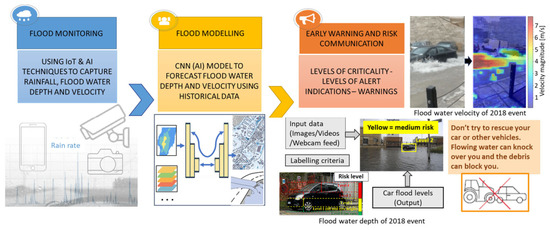
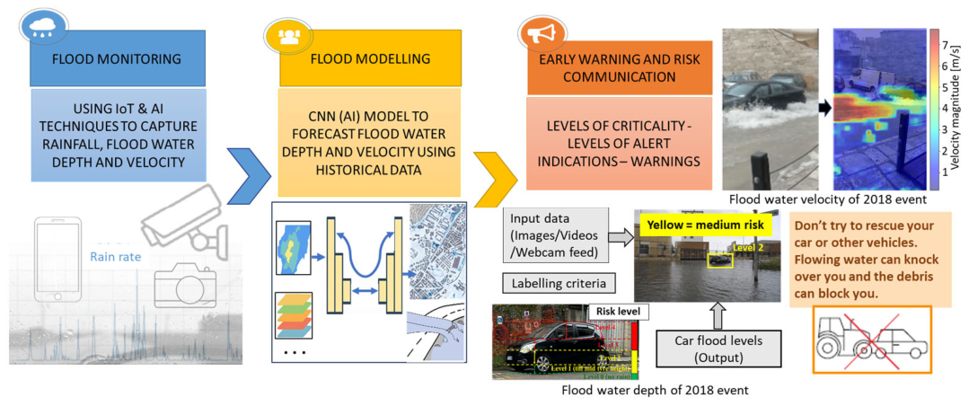
The composed flood EWS framework for the Matera case study is schematized in Figure 1 and each component of the system is described briefly in the following.
Figure 1.
Proposed early warning system for the city of Matera in South Italy.
The IoT camera network and AI technologies monitor the rainfall, water depth, and water velocity to enable the real-time prediction of extreme weather events and help citizens to understand the potential significance of possible related pluvial flood events. The gathered real-time data comes with high spatial and temporal resolution. These low-cost devices with high-performance connectivity can collect big data on meteorological parameters in a simple, fast, and smart way.
For the flood monitoring, IoT-based cameras are installed in the Matera case study for monitoring rainfall, and the video feed is integrated with object detection algorithms (you look only once (YOLO by Redmon et al. [4])) for computation of flood depths and risk level for car drivers to warn them of increasing water depths during flood events. The steps followed were collecting the data of cars submerged in floods across various parts of the world, mixed with various pieces of literature data [5], and labelling them into various hazard levels ranging from 0 (no risk, dry conditions) to level 4 (water above the window of the car) as defined in Liu et al. [6]. The YOLO model was trained for the labelled data and tested for various images such that an accuracy of about 70% was obtained [7]. The best weights of the model were saved and used for the further testing process, so that the model was fast and there was no need to train it again.
In addition, the surface velocity was estimated by Fudaa-LSPIV (Large-Scale Particle Image Velocimetry), an image-based particle velocimetry method using citizen-recorded images or videos of past extreme urban flash flood events [8]. Afterwards, the estimation of Fudaa-LSPIV was validated with SSIMS-Flow, an optical-flow based software, as well as benchmark data.
For pluvial flood modelling, this research developed an AI-based deep convolutional neural network (CNN) model for rapid and accurate real-time prediction of urban flash flood water depth, trained by the output of a physics-based model [9]. A total of 20 extreme rainfall events were considered, including past real flood events and synthetic events based on different return periods from 2 to 100 years, to develop an AI-based flood scenario modelling approach [1], which is an essential component of the EWS for understanding the local-scale impacts of extreme weather events and mapping water depths, water flow velocity, and consequent human instability thresholds, as well as potential critical situations in Matera city. The analysis of historical events and assessments of water depth, flow velocity and rainfall allow us to contextualize the meaning of future event scenarios (e.g., map of water depth and velocity with AI-based flood modelling) and therefore judge what level of protective action is necessary in different situations. When floodwater depth and flow velocity exceed threshold values, the pedestrian loss probability will identify and communicate by highlighting safe evacuation routes, managing road closures, and prioritizing road restoration [10]. Moreover, an ad hoc self-protection set of symbols and signals tells people what to do and what not to do in case (before, during and after) of a flooding event. Indeed, learning to prevent and reduce the consequences of catastrophic events is a responsibility shared by everyone: an effective prevention system not only comprises tools provided by competent authorities but also involves individual citizens who must adopt correct behaviours to avoid the dramatic effects of extreme events, based on essential information needed to activate life-saving actions.
3. Results and Conclusions
This research develops a citizen-oriented EWS by combining flood monitoring, modelling, and a risk communication system. It does not intend to replace the devices set up by qualified institutions but to be a support to enhance “flood literacy” amongst citizens. Moreover, it can also be used by authorities to support emergency management, providing reliable information about the timing of the flood recession stage, which is crucial for understanding which areas will be accessible first and which roads should be restored in a short time. The developed platform produces a technological evolution in risk prevention, no longer based on rigid practices, defined on static pre-event scenarios, but centred on transparent methods of real-time communication of hazard and risk to the population and behavioural instructions, improving not only the resilience of the territory but of the whole of society.
Funding
This work has been carried out within the scope of the “Tech4You” Innovation Ecosystem project, Notice no. 3277 of 28 December 2021—Intervention proposals for the creation and strengthening of “innovation ecosystems” PNRR–MUR project code: ECS0000009-CUP H23C22000370006Tec4you.
Data Availability Statement
The original contributions presented in the study are included in the article; further inquiries can be directed to the corresponding author.
Conflicts of Interest
The authors declare no conflict of interest.
References
- Asif, M.; Kuglitsch, M.M.; Pelivan, I.; Albano, R. Review and Intercomparison of Machine Learning Applications for Short-term Flood Forecasting. Water Resour. Manag. 2025, 39, 1971–1991. [Google Scholar] [CrossRef] [Scilit]
- Ermini, R.; Albano, R. Hydromorphic analysis of urban areas transformations: The case study of the Matera city. IOP Conf. Ser. Earth Environ. Sci. 2023, 1196, 012026. [Google Scholar] [CrossRef] [Scilit]
- Albano, R.; Sole, A.; Adamowski, J. READY: A web-based geographical information system for enhanced flood resilience through raising awareness in citizens. Nat. Hazards Earth Syst. Sci. 2015, 15, 1645–1658. [Google Scholar] [CrossRef] [Scilit]
- Redmon, J.; Divvala, S.; Girshick, R.; Farhadi, A. You only look once: Unified, real-time object detection. In Proceedings of the IEEE Conference on Computer Vision and Pattern Recognition, Las Vegas, NV, USA, 27–30 June 2016; pp. 779–788. [Google Scholar]
- Wan, J.; Qin, Y.; Shen, Y.; Yang, T.; Yan, X.; Zhang, S.; Yang, G.; Xue, F.; Wang, Q.J. Automatic detection of urban flood level with YOLOv8 using flooded vehicle dataset. J. Hydrol. 2024, 639, 131625. [Google Scholar] [CrossRef] [Scilit]
- Liu, B.; Li, Y.; Feng, X.; Lian, P. BEW-YOLOv8: A deep learning model for multi-scene and multi-scale flood depth estimation. J. Hydrol. 2024, 645, 132139. [Google Scholar] [CrossRef] [Scilit]
- Mishra, M.; Albano, R. FLOOD-DEPTH-ML: Machine Learning-Driven Python Application for Estimation of Urban Flood Depths through Submerged Vehicles Detection. Results Eng. 2026, 29, 109495. [Google Scholar] [CrossRef] [Scilit]
- Asif, M.; Dal Sasso, S.; Lacava, T.; Albano, R. Estimating flash flood surface flow velocity in heritage city using citizen-recorded videos. Prog. Disaster Sci. 2025, 28, 100474. [Google Scholar] [CrossRef] [Scilit]
- Albano, R.; Limongi, C.; Dal Sasso, S.F.; Mancusi, L.; Adamowski, J. Flood scenario spatio-temporal mapping via hydrological and hydrodynamic modelling and a remote sensing dataset: A case study of the Basento river (Southern Italy). Int. J. Disaster Risk Reduct. 2024, 111, 104758. [Google Scholar] [CrossRef] [Scilit]
- Albano, R.; Ermini, R.; Moramarco, T.; Sole, A. A physically-based conceptual model calibrated on experimental data for estimating the flood instability hazard for pedestrians in urban areas. Model. Earth Syst. Environ. 2026, 12, 132. [Google Scholar] [CrossRef] [Scilit]
Disclaimer/Publisher’s Note: The statements, opinions and data contained in all publications are solely those of the individual author(s) and contributor(s) and not of MDPI and/or the editor(s). MDPI and/or the editor(s) disclaim responsibility for any injury to people or property resulting from any ideas, methods, instructions or products referred to in the content. |
© 2026 by the authors. Licensee MDPI, Basel, Switzerland. This article is an open access article distributed under the terms and conditions of the Creative Commons Attribution (CC BY) license.