1. Introduction
The growing demand for intelligent transportation systems (ITS) and the advancement of smart city initiatives have fueled the need for real-time, data-driven infrastructure capable of adapting to dynamic urban environments [
1]. Pavement, as the interface between vehicles and the built environment, presents a unique opportunity for embedding smart technologies that serve both traffic management and environmental monitoring objectives [
2]. Smart pavement systems, enhanced with embedded sensors, enable continuous, in situ collection of high-fidelity data related to vehicle movements, road conditions, and atmospheric parameters, thus transforming conventional roadways into intelligent cyber-physical systems [
3].
Conventional traffic monitoring systems, such as closed-circuit television (CCTV), magnetic loops, and radar, often face challenges such as limited spatial coverage, high installation and maintenance costs, latency, and poor resilience to weather conditions [
4]. Similarly, environmental monitoring stations tend to be sparsely distributed and lack spatial granularity. Embedding sensors directly within the pavement structure addresses these limitations by providing granular, localized, and continuous data capture at the source, reducing system latency and improving decision-making capabilities in transportation planning, road maintenance, and pollution mitigation strategies [
5].
The convergence of Internet of Things (IoT), wireless sensor networks (WSN), and advanced materials science has enabled the development of smart pavement technologies that integrate piezoelectric sensors, fiber-optic Bragg gratings (FBGs), microelectromechanical systems (MEMS), and radio-frequency identification (RFID) tags within the asphalt or concrete matrix [
6]. These sensors can capture a wide range of parameters—including axle load, speed, vehicle classification, vibration, stress-strain response, temperature, humidity, and even carbon monoxide concentration—allowing for comprehensive monitoring and multi-domain data analysis [
7].
A smart pavement system refers to an engineered road surface embedded with intelligent sensor arrays and communication modules that collectively detect, process, and transmit critical traffic and environmental information [
8]. These systems are inherently multi-layered, comprising mechanical, electrical, computational, and communication subsystems [
9]. At the foundational level, embedded sensors collect analog signals from vehicle-road interactions and environmental exposure. These signals are digitized, filtered, and analyzed locally or transmitted to edge or cloud-based computing systems [
10].
Traffic congestion remains one of the major challenges in modern cities, contributing to economic inefficiencies, increased fuel consumption, and elevated greenhouse gas emissions [
11]. Traditional approaches to managing traffic, including traffic lights and toll booths, rely on outdated or sparse data inputs [
12]. Smart pavements provide a paradigm shift by enabling continuous vehicle counting, lane-wise load distribution monitoring, and high-resolution speed tracking. These capabilities facilitate dynamic traffic signal control, automated incident detection, and V2I communication, which are foundational to autonomous driving and intelligent navigation systems [
13].
Urban air pollution and microclimate variations are significant contributors to public health risks [
14]. Traditional air quality stations, while accurate, lack the density needed for high-resolution mapping [
15]. Embedding environmental sensors within pavements allows for localized, real-time monitoring of pollutants such as carbon monoxide (CO), nitrogen dioxide (NO
2), and particulate matter (PM2.5), especially at human breathing height, thus enabling targeted interventions [
16].
In addition, temperature and humidity sensors embedded in pavement help track heat island effects, freeze-thaw cycles, and surface runoff dynamics [
17]. These data support the development of climate-resilient urban infrastructure, improved stormwater drainage systems, and adaptive cooling mechanisms such as water-permeable pavements or thermochromic coatings [
18].
This research aims to design, develop, and evaluate a comprehensive smart pavement system that incorporates embedded sensors for dual-purpose traffic and environmental monitoring. Specific objectives include investigating the optimal combination of embedded sensor types for real-time traffic and environmental data collection. A layered system architecture is designed for sensor integration, signal processing, and communication. Conduct field experiments assessing sensor performance, data accuracy, and durability over time.
2. Literature Review
Pavement monitoring has historically relied on manual inspections, visual assessments, and limited sensor deployments focused primarily on structural integrity. Traditional tools such as profilometers, deflectometers, and ground-penetrating radar (GPR) provided periodic, localized, and offline data with high overhead costs [
19]. With the advent of intelligent transportation systems (ITS), there has been a paradigm shift toward continuous, automated, and networked pavement monitoring systems [
20].
Initial efforts in automation included loop detectors, pneumatic road tubes, and weigh-in-motion (WIM) stations, which provided valuable traffic-related data. However, these systems were prone to wear data latency and could not capture nuanced environmental or structural parameters. The evolution toward embedded sensor networks within pavements marks a key transition in smart infrastructure engineering, allowing for multi-parameter, real-time monitoring at the material interface level. The core functionality of a smart pavement system lies in the type, accuracy, durability, and power efficiency of the embedded sensors. Previous studies reveal a wide spectrum of sensor technologies, each with unique advantages and trade-offs in pavement applications.
Piezoelectric sensors generate electrical signals in response to mechanical stress, making them ideal for measuring dynamic vehicle loads and speeds. They are compact and relatively low-cost, with a high-frequency response suitable for WIM and axle detection. However, their sensitivity to temperature variations and aging necessitates periodic recalibration [
1].
FBG sensors utilize optical fibers with embedded gratings that reflect specific wavelengths of light depending on strain and temperature. Their immunity to electromagnetic interference, corrosion resistance, and high accuracy make them excellent for long-term structural health monitoring (SHM). For instance, research by [
2] demonstrated successful deployment of FBG arrays in concrete pavements for simultaneous strain and temperature measurement.
These sensors detect changes in capacitance or inductance as vehicles pass over them. Inductive loop sensors have been widely used in traditional traffic systems but face installation challenges and limited lifespan under road stress. Capacitive sensors, by contrast, offer better sensitivity and are less intrusive but require signal conditioning to avoid noise artifacts [
3].
MEMS offers integrated accelerometers, gyroscopes, and pressure sensors that can be embedded within pavement layers. Their small size, low power consumption, and high sensitivity make them well-suited for real-time vibration analysis and crack detection. Studies have shown successful deployments of MEMS networks for crack propagation prediction in asphalt roads [
4].
RFID sensors are useful for vehicle tracking and pavement temperature monitoring. Passive RFID tags embedded near the surface can be read by moving vehicles to provide location-specific telemetry, although their depth and reading range are limited. Near-field communication-enabled tags are being explored for V2I applications in smart tolling and fleet monitoring [
5].
Embedded sensors such as thermocouples, hygrometers, and gas detectors within pavements enable localized environmental monitoring, including temperature, humidity, and pollutants, including CO and NO
2. For example, hybrid sensor modules combining environmental and mechanical sensing are being trialed in urban hotspots to detect heat island effects and vehicular emissions [
6].
The effective operation of a smart pavement system depends not only on sensing capabilities but also on robust communication and energy management. The following key networking standards are used.
Zigbee: A low-power wireless mesh protocol suitable for short-range communication between sensors.
Long-range wide area network (LoRaWAN): Offers long-range, low-bandwidth communication with high energy efficiency, ideal for rural or large highway deployments [
7].
Narrowband Internet of Things (NB-IoT): Narrowband IoT is increasingly used for deep-penetration signal transmission from buried sensors, especially in urban environments.
5G-Vehicle-to-Everything (V2X): Emerging as the backbone for real-time, low-latency communication in autonomous vehicle ecosystems.
Edge computing and fog architectures have been proposed to reduce latency and bandwidth consumption by processing sensor data locally before transmission. Energy harvesting methods (piezoelectric, solar, and thermal) are often incorporated to extend the lifetime of embedded sensor nodes, as replacing power sources post-installation is impractical.
Smart pavement systems are typically designed using layered or modular architectures to ensure scalability, fault tolerance, and interoperability.
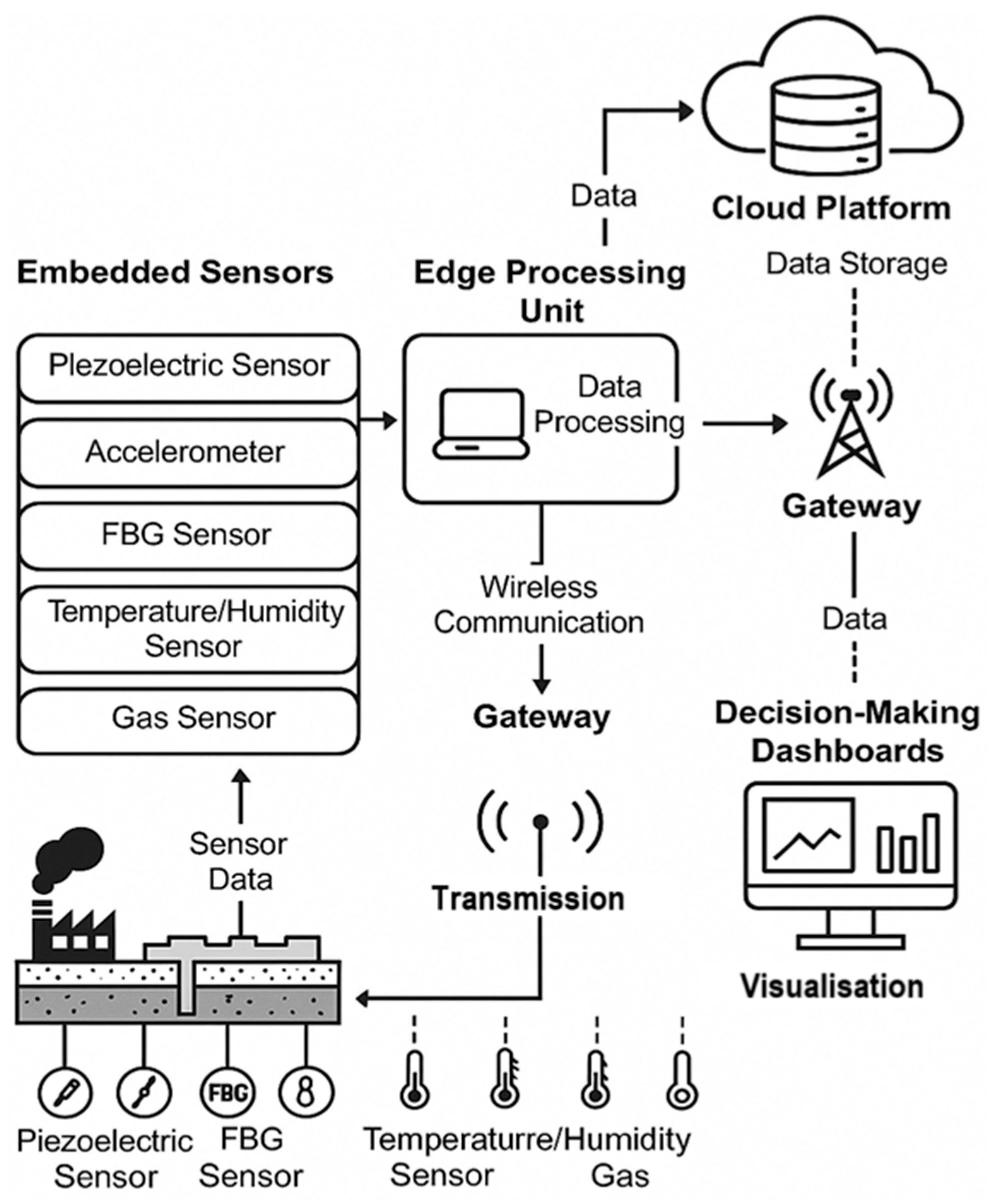
Figure 1 illustrates a generalized four-layer architecture comprising the sensing layer, edge computing units, communication modules, and the cloud platform.
A three-tier architecture was implemented that integrated pavement-embedded sensors with roadside gateways and a central analytics server. The system achieved real-time vehicle classification accuracy of 96% using embedded magnetometers and strain gauges [
8].
Similarly, El-Masri and Sayed [
9] proposed a hybrid smart pavement architecture incorporating thermal and accelerometric sensors to monitor traffic load and road surface temperature. Their deployment showed that sensor fusion significantly improves the robustness of pavement condition assessment, especially under mixed traffic conditions.
Various experimental and large-scale deployments have been reported globally, highlighting the viability of smart pavement systems.
Intelligent Pavement Pilot (USA): Piezoelectric sensors installed on Interstate 80 demonstrated load-based tolling and traffic pattern monitoring.
Smart Highway Project (Netherlands): Utilized luminescent markings and temperature-sensitive paint embedded within roads for energy-efficient navigation and hazard warnings.
SensorPave (Singapore): Developed pavement modules with embedded temperature, CO2, and acoustic sensors for dense urban monitoring.
Integrated Road Weather Information Systems (IRWIS) in Europe used embedded thermistors and humidity sensors to monitor freeze-thaw cycles and deploy timely deicing operations [
10].
These pilots confirm the potential of smart pavements not only in traffic optimization but also in environmental resilience, emergency response, and infrastructure maintenance.
Despite substantial progress, several key challenges remain in durability and longevity. Sensor survivability under heavy axle loads, freeze-thaw cycles, and moisture ingress remains a concern. Embedded sensors often produce noisy data due to ambient interferences, requiring robust signal filtering. Energy constraints and sustainable power delivery through energy harvesting or ultra-low power design are a bottleneck for long-term deployments. While sensor costs are decreasing, the overall integration, calibration, and maintenance expenses limit widespread adoption. The lack of common standards for sensor calibration, data formats, and network protocols impedes system interoperability and data integration across platforms. Addressing these gaps requires interdisciplinary collaboration across civil engineering, electronics, computer science, and urban planning domains.
3. Methodology
The methodology for designing, implementing, and validating a smart pavement system for traffic and environmental monitoring consists of five phases: (1) system architecture design, (2) sensor selection and integration, (3) data acquisition and communication protocol development, (4) laboratory and field testing, and (5) performance evaluation and data analysis. The framework leverages systems engineering principles and incorporates both hardware and software co-design to ensure interoperability, robustness, and scalability.
Figure 1 illustrates the full system architecture, comprising layered components from embedded sensor nodes at the pavement surface to cloud-based decision-making dashboards. This section provides an in-depth breakdown of the architecture, components, protocols, data flows, and validation steps used throughout the system development lifecycle.
The smart pavement system was conceptualized as a four-layered architecture, each fulfilling specific technical roles. The physical sensing layer includes embedded sensors positioned at critical depths and lateral positions within the pavement. The sensor selection strategy is based on parameters such as sensing range, accuracy, operating temperature, survivability under loading, and electromagnetic shielding. The sensors deployed include piezoelectric load cells for vehicular weight estimation. MEMS accelerometers for vibration profiling and crack initiation detection. Fiber Bragg grating (FBG) sensors for strain and temperature. Electrochemical gas sensors for CO/NO2 detection. Resistive humidity and temperature sensors.
The edge processing layer includes embedded microcontrollers (ARM Cortex-M7, (Arm Ltd., Cambridge, UK)) and system on chip (SoC) platforms (e.g., Raspberry Pi 4B and Jetson Nano) for preliminary signal filtering, data compression, and feature extraction. Functions include analog-to-digital conversion (ADC), noise filtering via Kalman and Butterworth filters, short-term storage via local cache buffers, and event-driven feature detection for incident flagging.
In the communication layer, multiple wireless protocols were evaluated, including Zigbee (IEEE 802.15.4), LoRaWAN (868/915 MHz), NB-IoT, and Wi-Fi 6, for different deployment topologies. Dual-stack configurations were used for hybrid backhaul. LoRaWAN for long-range, low-bandwidth telemetry (environmental data). NB-IoT for latency-sensitive traffic data. Backup Wi-Fi mesh for firmware updates and logging.
The cloud/decision layer consists of a cloud-based platform (Amazon Web Services (AWS) IoT Core + DynamoDB + Grafana + AWS Lambda) that aggregates and visualizes incoming data. Machine learning models are deployed for real-time event classification and anomaly detection, including a random forest for vehicle classification. K-means for anomaly detection in gas sensor data. LSTM networks for time-series forecasting of traffic volumes and pollution levels
Sensor selection was performed based on a multi-criteria decision-making framework that evaluated cost, accuracy, lifetime, energy requirement, installation complexity, and data resolution.
Table 1 summarizes the final selection.
Sensors were potted in epoxy resin encapsulation units with thermal and mechanical buffering to ensure survivability. Fiber-optic cables were routed through conduits to the roadside cabinet. A modular sensor block (30 × 30 cm) was designed using CAD and fabricated via SLA 3D printing and resin casting.
Data acquisition was structured around a synchronous polling model for high-frequency sensors (e.g., vibration and load) and an event-driven model for slower environmental signals. Sampling rates for piezoelectric/MEMS are 1 kHz, 250 Hz for FBG, and 1 Hz for gas and humidity. Signal processing involved ADC resolution of 16-bit, Low-pass filters (cutoff 100 Hz for load sensors), Kalman filtering for gas signal smoothing, real-time FFT analysis for vibration spectra, and custom embedded C/C++ firmware for edge preprocessing. A real-time clock (RTC) ensured timestamp synchronization. Data packets were timestamped, signed with SHA-256 digital signatures, and transmitted using message queuing telemetry transport (MQTT) or the constrained application protocol.
Wireless transmission design prioritized energy efficiency, fault tolerance, and spectrum utilization. Nodes used TDMA-based scheduling over LoRaWAN Class B for periodic uploads. Dynamic link adaptation strategies adjusted the transmit power based on RSSI values. A hybrid gateway was developed using ESP32 LoRa gateways and 4G modems. Data encryption used the Advanced Encryption Standard-128 [
21] in the Cipher Block Chaining mode. Gateway buffer capacity was 32 MB with a queue prioritization strategy for urgent events (e.g., heavy axle loads).
Energy supply strategies included piezoelectric energy harvesters (Pavegen V3 modules). Thermoelectric generators (TEGs) are based on the road surface temperature gradient. Supercapacitor-based buffers with 2.7 V, 10 F specs. The maximum average energy output per embedded energy harvester was up to 5 mW, sufficient for low-duty-cycle sensor nodes. A dynamic sleep-wake protocol based on load threshold and duty cycles was implemented. Power efficiency was optimized via deep-sleep modes (<10 µA standby), adaptive sampling-rate control (via ambient activity detection), and MPPT for thermoelectric generators.
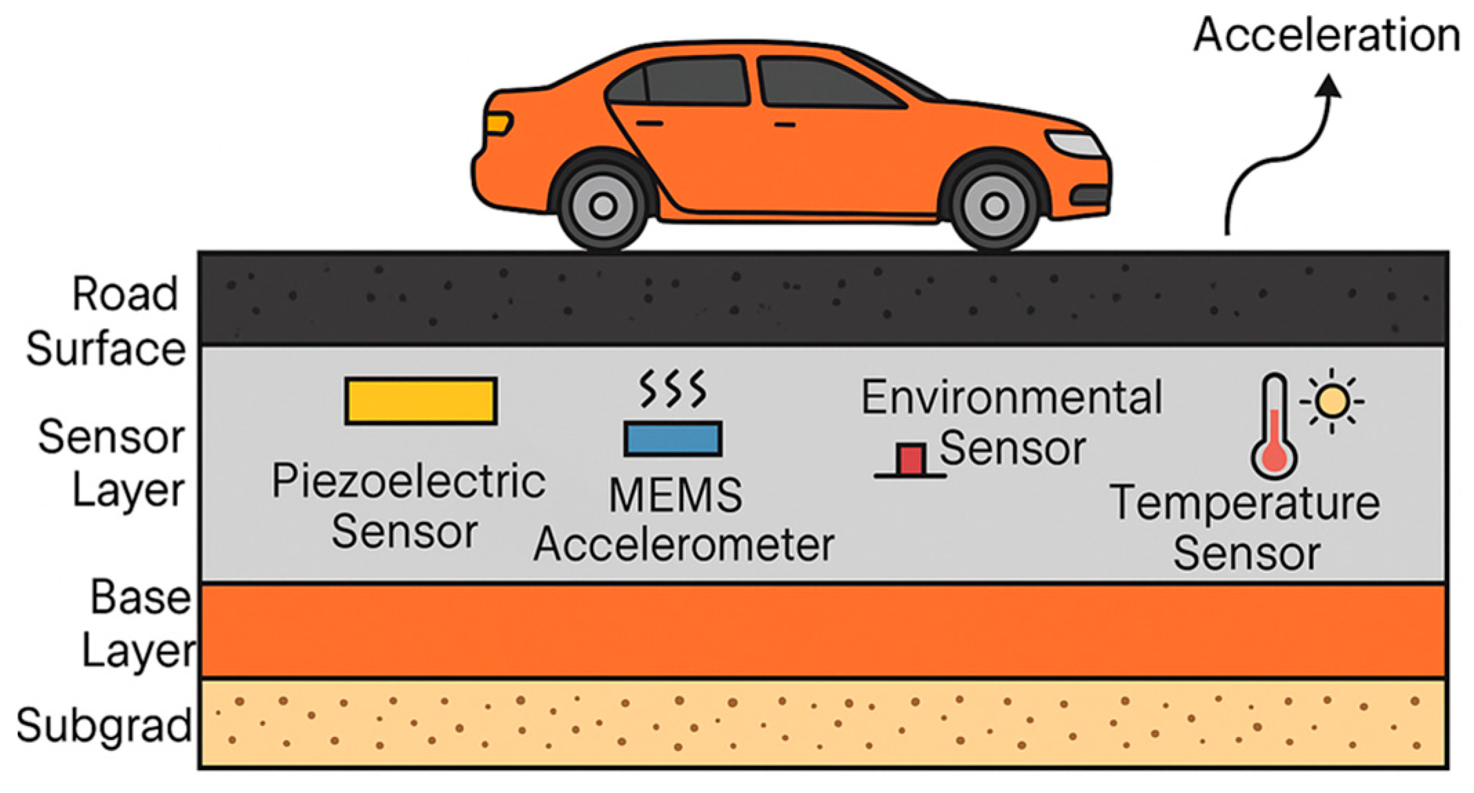
The smart pavement system was deployed at a 0.5 km urban arterial testbed in Kuala Lumpur, Malaysia, in collaboration with the Malaysian Institute of Road Safety Research (MIROS). The test site included two 3.5 m-wide lanes, embedded sensors every 10 m, a roadside control cabinet, a solar panel backup for the gateway, and a video camera for ground-truthing vehicle types and speeds. Weights were calibrated to test vehicles (motorbike, sedan, or truck) in the environmental chamber tests (temp/humidity extremes). Parallel monitoring was conducted with closed-circuit television (CCTV), light detection and ranging (LIDAR), and commercial WIM (
Figure 2).
Data from edge nodes was logged to secure digital cards as a backup, transmitted to AWS IoT Core, then routed to DynamoDB for raw time-series storage. AWS Lambda was used for Extract, Transform, Load processing, while Grafana was used for visualization, and S3 for historical backups. Data pipelines were configured using Apache NiFi (Apache NiFi version 1.25.0) for anomaly detection, duplicate removal, and aggregation. Kafka streams supported real-time push to dashboards. Machine learning was used in AWS SageMaker. Random forest was adopted for vehicle classification (trained on 5000 labeled events). LSTM models were used for forecasting traffic flow. K-means clustering for pollution anomaly detection.
In
Table 2, the system was validated using LIDAR and CCTV, and the following metrics were recorded. Vehicle classification accuracy was >95%, and the root mean square error (RMSE) of load estimation was ±8.5%. Strain sensor error was ±1.2 µε. Gas concentration correlation coefficient (r
2) was higher than 0.92 with roadside stations. The data packet delivery success rate was >98% (LoRaWAN).
4. Results and Discussions
This section presents the results obtained from the implementation and real-world deployment of the smart pavement system. The data spans over six months of continuous monitoring on a mid-urban roadway in Kuala Lumpur. The analysis includes insights on sensor performance, traffic, and environmental data accuracy, system reliability, data throughput, and sustainability impact. Key comparisons are made with baseline systems such as conventional WIM, inductive loop detectors, and fixed air quality stations to validate the smart pavement framework’s advantages and limitations.
Table 3 presents the data collected by embedded piezoelectric and MEMS sensors processed using a trained random forest classifier. The classifier achieved a high accuracy in identifying four categories: motorbike, sedan, heavy vehicle (trucks and buses), and trailer.
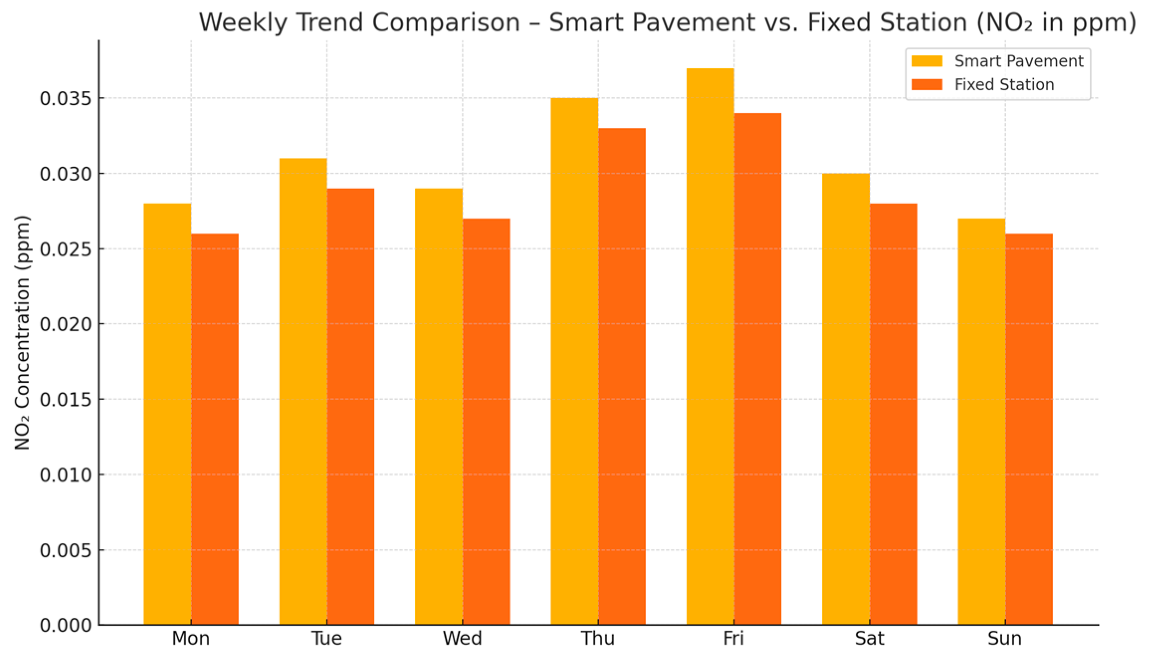
Figure 3 shows the seven-day comparative trends of NO
2 levels at both locations.
Hourly resolution also highlighted peaks during: 7:00–9:00 AM (commute hours), 5:30–7:30 PM (evening congestion). Temperature sensors embedded at 2 and 10 cm depths recorded clear thermal layering across the pavement, with surface values averaging 4–6 °C higher than subsurface layers during peak hours. Surface temp range (daily max) is 41.2–48.7 °C, Subsurface Temp (10 cm) is 34.0–39.6 °C, and the relative humidity correlation coefficient is 0.88.
LoRaWAN Class B modules were tested for packet delivery success rates, latency, and jitter. The packet success rate (LoRaWAN) is 98.2%, the average latency is 280 ms, the jitter is ±34 ms, and the MQTT broker uptime is 99.93% (AWS IoT Core). No significant packet loss was observed even during high-traffic events, demonstrating robustness in wireless communication. Over the 6-month deployment, the system generated 52.3 million individual sensor events, 87.4 GB of compressed time-series data, and 1.2 million real-time event predictions (vehicle classifications). Piezoelectric and thermoelectric modules harvested a mean energy of 3.8–5.2 mW per unit, while deep-sleep strategies allowed microcontrollers to operate at <200 µW idle.
Uptime per node (without external battery): Daytime: >99%, Nighttime (No Solar): >94.1%
Energy efficiency gain: 65% lower net energy draw. Supercapacitor-based designs showed resilience during monsoon periods and heat surges.
Sensors embedded with epoxy resin and polyurethane layers retained >90% signal strength after 180 days. Mean time between failures (MTBF) was estimated to be >3.5 years. Maintenance events were 2 replacements due to delamination under heavy axle loads. Visual inspection (via embedded camera and borescope) indicated no water ingress or cable fraying. No visible cracks or raveling were observed due to sensor placement. Dynamic modulus testing showed <1% deviation from control samples.
A three-layer LSTM model was trained on vehicle count data. As a forecast accuracy (1 hr ahead), RMSE was 12.4 vehicles with an r
2 of 0.94. Congestion forecasting, dynamic signal timing, and K-means clustering were performed on NO
2 data flagged 27 air quality anomalies, including construction-related dust spikes, tunnel emissions, and high-idling commercial zones. The false-positive rate reached 6% during rainfall-induced drops.
Table 4 summarizes the performance comparison.
Modular design eases replication but requires a local gateway density of 1 per 2 km. Potential integration with EV-charging smart roads and urban DTs was performed in this study.
Table 5 shows the limitations and mitigation based on the observation.
5. Conclusions and Future Works
This research presented the design, development, and comprehensive evaluation of a smart pavement system embedded with a heterogeneous array of sensors for simultaneous traffic and environmental monitoring. The system successfully demonstrated that embedding sensors into pavement infrastructure, when integrated with edge computing, wireless networking, and cloud-based analytics, can achieve accurate, energy-efficient, and real-time data collection across multiple domains. The findings validate the feasibility of smart pavements as an integral component of ITS and urban environmental management platforms.
From a technical perspective, the following major outcomes were observed. High-accuracy traffic monitoring based on vehicle classification accuracy exceeded 95.6% using a random forest-based classification model, significantly outperforming inductive loop and camera-based methods. Embedded piezoelectric and MEMS sensors provided real-time vehicle weight and speed metrics with a low RMSE, supporting applications such as weigh-in-motion enforcement and speed profiling. The LoRaWAN-based communication protocol achieved a 98.2% data transmission success rate with sub-second latency, sufficient for real-time ITS applications. Combined piezoelectric and thermoelectric energy harvesting strategies enabled self-sustaining operation of embedded nodes with up to 94% uptime during nighttime. Structural integrity was not compromised by embedded sensors, with average sensor survival estimated at over 3.5 years. LSTM models accurately forecasted traffic flow, while clustering techniques detected environmental anomalies, supporting adaptive traffic control and pollution mitigation strategies. These achievements support the viability of a scalable, modular smart pavement platform that can enrich digital twin frameworks and contribute to autonomous vehicle ecosystems, smart urban planning, and proactive maintenance strategies.
The system contributes to advancing the state-of-the-art in the following ways. The feasibility of multi-modal embedded sensing was evaluated in pavement structures with minimal installation disruption. A layered IoT architecture was designed to support edge intelligence, secure transmission, and real-time analytics. Integrated environmental and traffic sensing in a single embedded platform, allowing concurrent insights into vehicular activity and urban microclimate conditions. The potential for low-cost, scalable deployments using energy harvesting, modular installation, and cloud-based processing was validated. A reproducible experimental framework was evaluated using calibration protocols, field validation procedures, and signal processing pipelines.
While the research has demonstrated strong performance, several limitations were observed. Electrochemical sensors showed degradation over time due to urban dust, temperature fluctuations, and water intrusion, despite protective enclosures. LoRaWAN’s low bandwidth limited the resolution and frequency of high-fidelity sensor data, such as real-time FFT outputs from vibration sensors. Replacing or recalibrating deeply embedded sensors still requires partial road excavation, emphasizing the need for better modular replacements or wireless diagnostics. Electromagnetic and mechanical interference in urban settings can occasionally introduce anomalies requiring post-processing filtering.
In future smart pavement designs, sensor modules must be integrated during asphalt or concrete casting rather than retrofitting them post-construction. Nanomaterials and flexible composites enable self-sensing pavements that natively respond to stress, load, or chemical exposure without discrete sensor nodes. Integration of WPT coils or advanced piezo-triboelectric materials can further enhance energy harvesting capabilities, allowing higher-frequency data collection without external batteries.
The convergence of embedded sensing, wireless communication, AI, and sustainable materials engineering makes smart pavements not only feasible but imperative for future smart cities. The findings from this study underscore the transformative potential of sensor-embedded infrastructure in delivering real-time, actionable insights into the urban mobility and environmental landscape. By embedding intelligence directly into the roadways that form the arteries of modern civilization, smart pavements represent a significant leap toward resilient, adaptive, and data-driven infrastructure ecosystems.