1. Introduction
Effective management of active vegetation fires is difficult to imagine without predicting their behavior. Vegetation fire behavior is understood as its distribution over a specific area, that is, the dynamics of its contour, type, and intensity of the fire. This also includes the dynamics of the direct impact of combustion on biogeocenoses and the assessment of its immediate consequences (primarily post-fire mortality in a forest stand).
In the world practice of studying the nature of vegetation fires and the development of information databases for fire behavior prediction, three methodological approaches can be conventionally distinguished: (1) selective, (2) standard, and (3) individually standard. Each of the listed approaches is based on its own specific classification of vegetation fuels (VF), developed by a specific period of time in a specific country. Since natural conditions and methodological approaches to the pyrological classification of vegetation vary significantly in different countries, it is difficult to simply borrow the developed classifications. Therefore, forested countries, such as Canada and Russia, are developing their own VF classifications, and non-forested countries, such as Australia, are trying to put into practice the pyrological classification of vegetation, which has long been created and is being improved in the United States.
To predict the behavior of vegetation fires, it is necessary to create an entire system that includes not only software but also an information database that contains information about the distribution of VF complexes over the territory and about their properties and ignitability under various weather conditions. It is desirable to have information on VF complexes and on the conditions of drying and moistening of hygroscopic VFs in the context of fairly homogeneous areas, namely, biogeocenoses. Clear quantitative criteria for the identification of biogeocenoses in Russia have not been developed; therefore, in practice, forest inventory plots have to be taken as homogeneous areas. When a fire reaches a significant size, its spread will depend on the pyrological characteristics of background vegetation in the area, since the fire can simply bypass certain non-flammable areas in it.
2. Background
Let us briefly dwell on the essence of the above-mentioned methodological approaches used in the USA, Canada, and Russia.
A
selective method implies that the ignitability of certain categories of vegetation areas (biogeocenoses) is empirically studied in connection with dynamic external factors: weather conditions and phenological periods. The method was used in Russia and Canada. For instance, in the 1960–1970s, observations were carried out according to Dr. N.P. Kurbatsky’s method [
1] in various regions of Russia and in certain types of forests. The focus of the observations was on the dynamics of the moisture content and fuel loads of surface cover and duff, as well as fire spread occurrence in relation to weather conditions. Local scales on the ignitability of the studied forest types were compiled. However, there is a large number of forest types with their regional characteristics on the territory of Russia, and it would take a long time to study the pyrological characteristics of each type of forest. Therefore, in the 1970–1990s, under the leadership of the founder of Forest Fire Science in Russia, Dr. Ivan S. Melekhov, patterns of moistening, drying, and combustion of surface covers and, above all, the primary fire carriers, which determine the possibility of vegetation fire occurrence and spread, attracted the attention of forest fire scientists [
2,
3,
4]. Subsequently, these studies served as the basis for the development of an
individually standard method for creating information databases for fire behavior prediction.
Based on the
selective method, 16 categories of vegetation sites (called
fuel types in the Canadian Fire Behavior Prediction System) obtained a comprehensive pyrological description via experimental fires. These
fuel types are provided with estimates of available VF load, as well as fire spread rate and intensity under various weather conditions. Fuel types are categories of sites related to (A) forested areas including coniferous forests (7 types), deciduous forests (1 type), mixed forests (4 types); (B) cleared areas in the form of cuttings (3 types), and (C) non-forest area including grasslands (1 type) [
5]. It is arguable that there are many more fuel types in Canada. Their pyrological characteristics are studied further via experimental and wildland fires. Apparently, principles for identifying standard VF complexes have not been developed yet; therefore, there is no classification of the entire diversity of Canadian forest vegetation into forest types. The inability to provide an accurate pyrological description of any area, covered or not covered with vegetation, interferes with the development of detailed large-scale VF maps necessary for fire behavior prediction and fire management. The total number of categories of vegetation sites (at the level of types of biogeocenoses) is large, so only some of them can obtain an experimental pyrological description. However, when predicting the behavior of vegetation fires in a given area, the pyrological description of all sites with and without vegetation is necessary. The
selective method cannot provide this information.
Under a
standard method, all vegetation (forest and non-forest) is divided into pyrological types, i.e.,
fuel models. This method has been used in the US National Fire Danger Rating System (NFDRS) and Wildfire Behavior Prediction (BEHAVE) [
6]. In the United States, vegetation was first divided into
13 fuel models forming four groups: grass, shrub, timber, and slash. The fuel models differ in the distribution of VF load by class, the height of the VF layer, as well as fire spread rate and flame height under standard conditions [
7]. Later, a division of the US vegetation into
40 fuel models was developed. Among these 40 fuel models are grass (9), grass-shrub (4), shrub (9), timber with dense undergrowth (5), timber with litter (9), and slash (4). There are also five fuel models for non-flammable areas [
8,
9]. The advantage of the standard method is that the pyrological description necessary for fire behavior prediction is provided for each site in the area assigned to one or another model. However, this pyrological description is rough due to the limited number of fuel models.
An
individually standard method was developed in Russia at the Sukachev Institute of Forest SB RAS on the basis of long-term fundamental pyrological research carried out in different regions of the country. The idea of this method implies that an individual approach is used for the pyrological description of vegetation sites reflecting their specific features and pyrological characteristics obtained as a result of studying patterns of moistening, drying, and burning of the types of primary fire carriers (PFC types) in relation to weather conditions and the forest inventory characteristics of tree stands. PFC types constitute a group of surface VFs, which predetermine fire occurrence and spread. Without the support of surface fire, crown fires can only spread over a limited distance. Minor fire carriers include canopy needles and foliage during a crown fire and duff and peat during a ground fire when combustion slowly spreads in the form of smoldering. Vegetation areas have a large variety of combinations of VF groups and types, conditions of VF moistening, drying, and burning, regional differences in VF complexes (especially in relation to their fuel load), etc. This proves the need to use not a standard, but an
individual approach in the pyrological description of sites, reflecting the uniqueness of each of them. In practice, individual characteristics of sites can be composed of a number of
standard elements, as is done in forest inventory. Therefore, it is better to call the method
individually standard. A technique has been developed to provide an area of vegetation with an individual pyrological characteristic and thus to form an information database on the basis of available descriptions (for example, forest inventory) or aerospace images [
10]. In addition, there is a specially developed guide to PFC types [
4,
11]. This PFC guide began to be used in Russia in the forest inventory of protected areas [
12].
3. Materials and Methods
Historically, many fire science studies began almost simultaneously in major forest countries and were carried out in parallel and independently of each other, and the methods used in the classification of vegetation and the methods for assessing the fire hazard of areas (forest and non-forest) differed significantly. Only in the early 1990s, Russian forest fire scientists obtained the opportunity to participate not only in international fire science conferences abroad but also to undergo scientific internships there. By this time, they were aware of the development of the US (NFDRS, including the BEHAVE system) and Canadian (CFFBPS) systems for assessing fire danger and predicting the behavior of vegetation fires. Russian forest fire scientists, co-authors of this article, A.V. Volokitina and T.M. Sofronova, having studied the developed foreign systems during long-term internships in Canada (1995) and the USA (1997, 2008–2009, 2010–2011), came to the conclusion that it is difficult to use them on the territory of Russia due to the different approaches to the pyrological classification of vegetation and set the task of developing the Russian system for fire danger rating and fire behavior prediction through a synthesis of Russian long-term pyrological studies, including the results of their own observations and elaborations [
4,
13,
14,
15,
16,
17,
18,
19].
Since any system should be based on a VF classification, it was necessary to synthesize the results of available pyrological studies in different regions of Russia: observations of ignitability dynamics in different types of forests (carried out according to Dr. N.P. Kurbatsky’s method), as well as studies on the development of a VF classification, and methods for their mapping (begun under the guidance of Dr. I.S. Melekhov) [
2]. The final classification was published in 2002 [
4]. It was the basis for creating a prototype of the Russian system for fire danger rating and fire behavior prediction on the example of the Chunsky Forest Office territory in the Krasnoyarsk Angara region, on an area of about 1 million hectares [
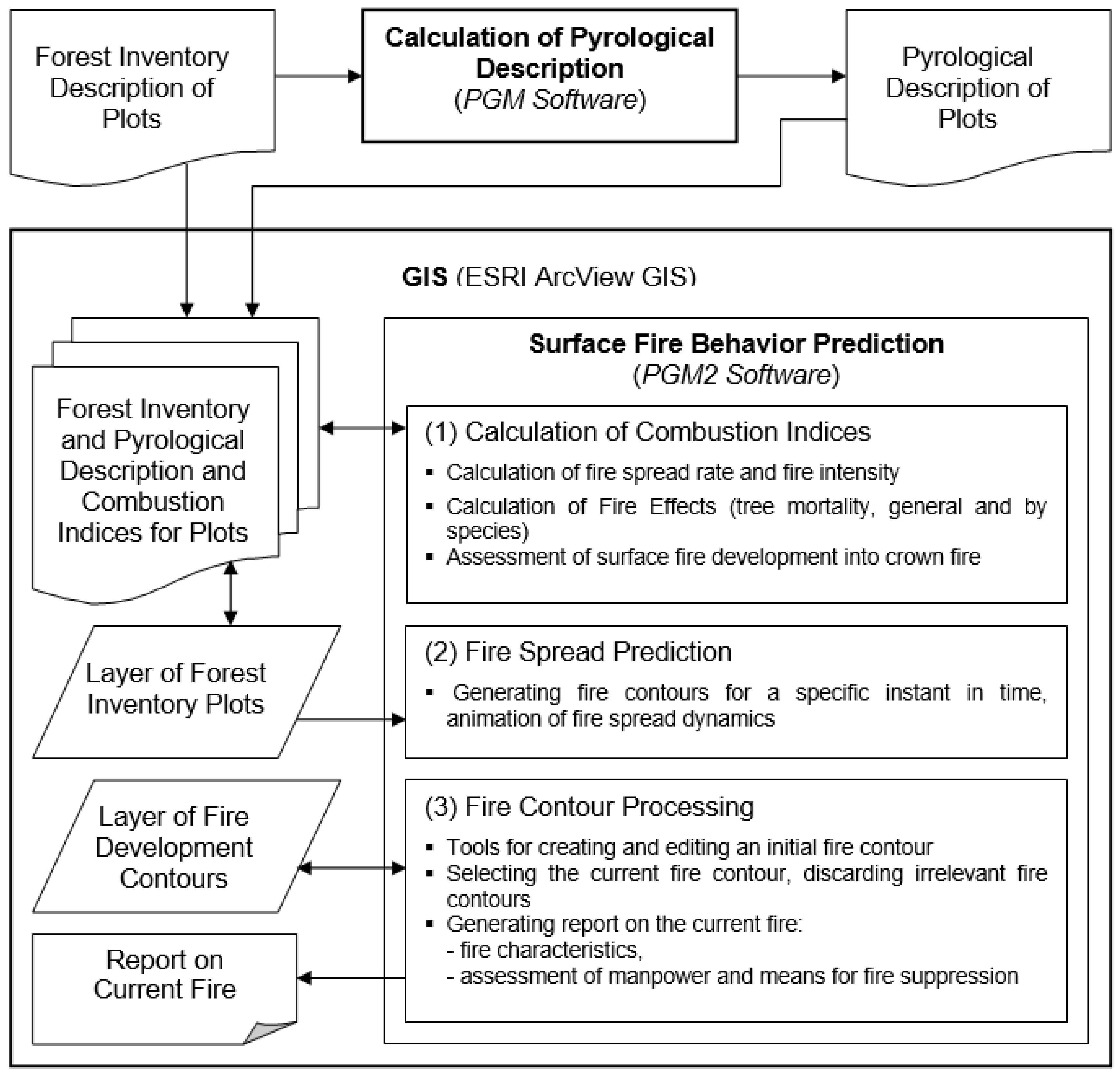
20]. An information database was created in GIS for making large-scale VF maps and for fire behavior prediction based on them by using specially designed software,
PGM and
PGM2 [
21,
22], the performance of which was retrospectively tested by analyzing past fires. The procedure for this verification is given below.
The first stage of the software performance test included the prediction of ignitability dynamics for vegetation areas, i.e., the assessment of the readiness of these areas to ignite before a fire starts. At this stage, the performance test was carried out in the lowlands of the Chunsky Forestry Office territory characterized by high fire occurrence. For its area of about 1 million hectares, large-scale VF maps were made with the help of the developed PGM software for the spring–fall and summer periods of a fire season. We obtained information from about 125 wildfires that had occurred in this area in different years. Forest fire protocols and fire outlines attached to them helped to identify the numbers of inventory plots that had been covered by fire, and the VF map helped to identify their critical drought classes (CDC) for a given period of the fire season. A CDC is a fire danger class (according to weather conditions) when fire occurrence and fire spread are possible in the given PFC type (CDCs have been identified by us for all PFC types as a result of numerous experimental ignitions under natural conditions). According to the weather data obtained from the nearest weather station, the Russian fire weather index was calculated, and the drought class (DC) was determined for each day using the following scale: 1st DC—up to 300; 2nd DC—301–1000; 3rd DC—1001–3000; 4th DC—3001–10,000; 5th DC—more than 10,000 conventional units of the fire weather index.
When comparing the drought classes of the days when fires were active with the critical drought classes in the burnt areas, it was found that 117 fires out of 125 operated in the areas which were in an ignitable state, and only 8 fires were active in the plots which were in a transient state according to the fire hazard prediction by the developed software. Among the burnt plots, there were none in a non-ignitable state according to the fire hazard prediction. Thus, the performance test showed that the assessment of ignitability dynamics for inventory plots according to the VF map and weather conditions was reliable.
The second stage of the retrospective performance test for our fire behavior prediction software (PGM2) required a lot of additional information, which was often missing from the fire protocols or was not accurate. Therefore, for the second stage of this performance test, it was only possible to obtain all the necessary data for 26 fires out of 125 in the Chunsky Forest Office. Additionally, to test the PGM2 software operation in mountain conditions, we selected 10 past fire events in the Stolby Nature Reserve where there had been an information database and large-scale VF maps had been made. It should be noted that fires in nature reserves occur rarely due to protection conditions.
To reasonably predict the behavior of vegetation fires, including forest ones, the following conditions are necessary:
Availability of VF maps in GIS with pyrological description for periods of a fire season;
Positioning of fire with an accuracy of hundredths of a minute (GPS geographical coordinates are within the accuracy of 0.001 min);
Possibility to include GIS information about the starting point of a fire or about its contour, not only in terms of coordinates but also in terms of a fire outline (scheme, drawing);
Availability of the following weather information:
- (a)
the value of a fire weather index, units;
- (b)
relative air humidity, %;
- (c)
wind speed, m/s;
- (d)
wind direction (azimuth, rhumb);
- (e)
daily amount of precipitation, mm;
- (f)
weather forecast of the above values (items b and e) not less than a day ahead, with differentiation by parts of a day (afternoon, evening, night, morning) or with an interval of 1–3 h;
Information about forest fires. This information is available in fire protocols and special accounting cards. In addition to the protocol, each forest fire should be provided with a Forest Fire Suppression Report providing the following data:
- (1)
geographical coordinates of a fire;
- (2)
date and time of fire detection;
- (3)
area of a fire at the time of detection;
- (4)
wind speed (with wind direction), m/s;
- (5)
fire danger class;
- (6)
dominant tree species;
- (7)
type of surface cover (lichen, green moss, grass, etc.);
- (8)
category of land (plantation, open forest, burnt area, cutting, swamp, etc.);
- (9)
suppression start time;
- (10)
time of fire containment;
- (11)
fire suppression end time;
- (12)
forested area covered by fire, ha;
- (13)
forested area covered by crown fire, ha;
- (14)
forested area covered by ground fire, ha;
- (15)
non-forested area covered by fire, ha;
- (16)
cost of suppression services;
- (17)
general damage (including the cost of burned timber, clearing costs, and restoration costs), etc.
The main criterion for selecting past fire events for retrospective performance tests was the quality of fire outlines. Preference was given to GIS-based outlines which is very important for the accurate positioning of fires for computerized prediction of their spread. The outlines helped to identify the initial and final contours of a fire. Intermediate contours were, unfortunately, absent in almost all outlines. The initial and final contours of the fire were transferred to the computerized VF map. The following data were entered: fire season period, fire weather index value, relative air humidity, wind direction, and wind speed. Then, fire spread was predicted using the developed PGM2 software in the Avenue object-oriented programming language as a software module operating in ESRI ArcView GIS 3.2 (Redlands, CA, USA).
The software can be installed on a personal computer running a Windows operating system (SE, 200, XP). System requirements include an Intel-compatible processor, RAM of at least 56 MB, and a hard disk space of at least 100 MB. The ESRI ArcView GIS 3.2 GIS package should first be installed on the computer.
4. Results and Discussion
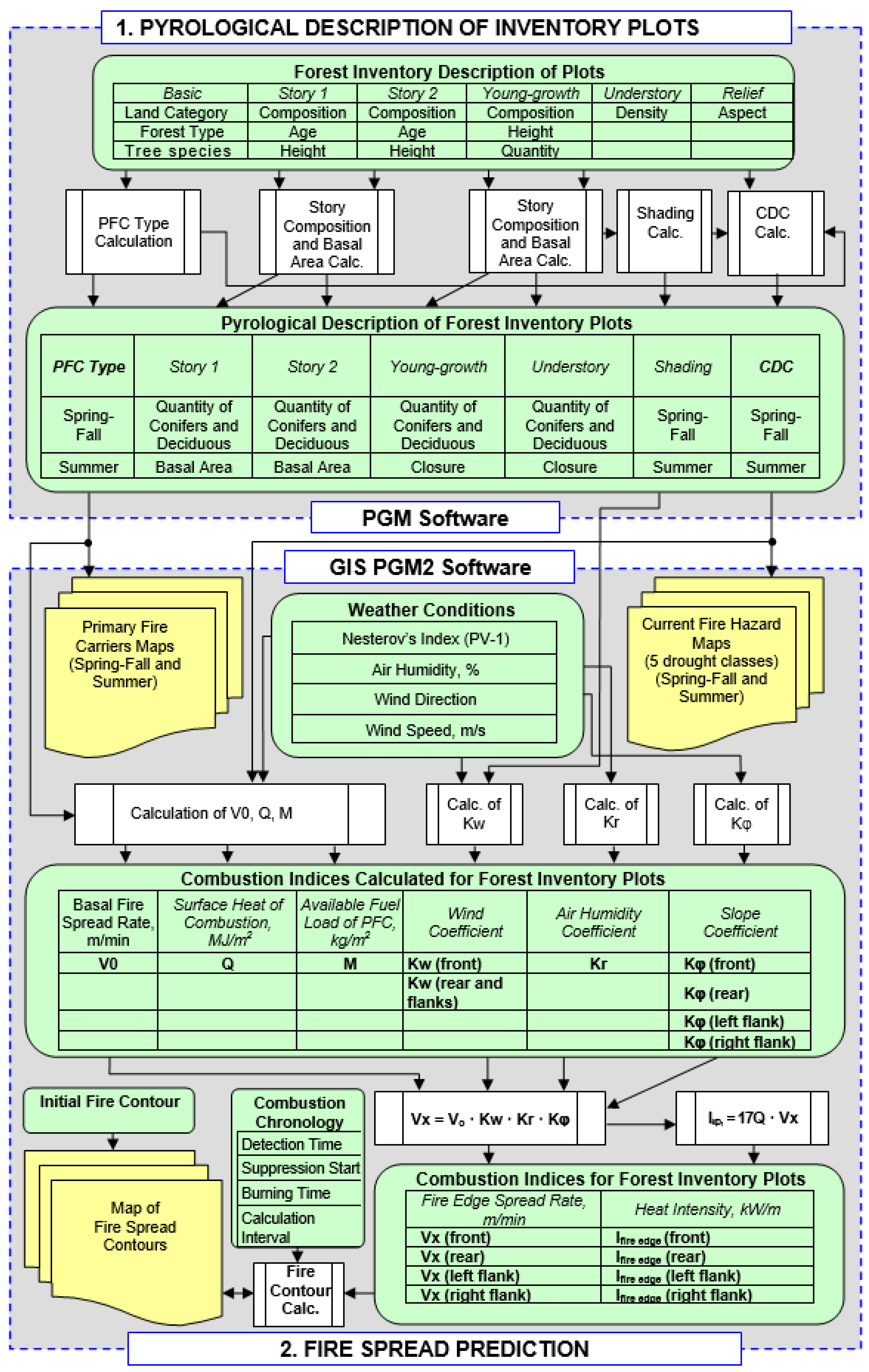
An
individually standard method for the development of information databases for predicting the behavior of vegetation fires is being developed in Russia at the Sukachev Institute of Forest SB RAS. The idea of the method is to develop individual pyrological characteristics of vegetation sites from a set of standard elements that reflect the description of the VF complex components, as well as conditions for the moistening, drying, and burning of primary fire carriers. A technique has been developed to provide an individual pyrological characteristic for any area of vegetation and thus to create an information database using available descriptions (for example, forest inventory) or airborne images [
10].
Let us consider this method in detail. The main condition for the existence of a forest fire is its spread over the area covered with vegetation fuels (VFs), that is, plants and plant residues. Forest biogeocenoses are three-dimensional VF complexes of a certain structure, associated with environmental conditions. Species diversity of vegetation fuels, dynamics of their load, and moisture content are great both in space and in time. This predetermines the diversity of probability and nature of burning on vegetation sites, as well as fire effects. For an informative description of VF complexes, their relatively perfect classification is needed.
VF classification. In the US’s NFDRS and BEHAVE systems, when characterizing fuel models, the classification of dead VFs is used. It is divided into four classes according to their drying rate, namely, according to the time lag. The time lag is the time for a VF sample to lose moisture in the amount of 2/3 of the initial moisture content when dried in air under a temperature of 26.5 °C and a relative humidity of 20%. The first class includes VFs with an average time lag of 1 h (0–2 h); usually, these are dried-up grass plants and timber particles up to 6 mm in diameter, as well as upper layers of litter, up to 6 mm thick. The second class includes VFs with an average time lag of 10 h (2–20 h); usually, these are fallen branches with a diameter of 6 to 25 mm, as well as layers of litter and duff at a depth of 6 to 25 mm. The third class consists of VFs with an average time lag of 100 h (20–200 h); this is dead timber with a diameter of 26 to 75 mm, as well as duff layers located at a depth of 25 to 100 mm. The fourth class has VFs with an average time lag of 1000 h (from 200 to 2000 h); this is dead timber with a diameter of 76 to 200 mm, as well as layers of duff (peat) located at a depth of 100 to 300 mm. Moss and lichen covers characteristic of boreal forests are not included in the US classification.
It is notable that almost all US fuel models indicate the load of the first VF class as sufficient for fire to spread (more than 0.2 kg/m
2). Therefore, all fuel models with similar shading conditions (for example, the presence of a forest stand) should almost simultaneously reach the ignitable state. At the same time, long-term studies on ignitability dynamics in various types of forests in different regions of Russia, carried out using Kurbatsky’s method [
1], proved that differences in ignitability dynamics under similar weather conditions can range up to 10 days or more.
These differences are explained by the fact that the drying rate of surface VF layers serving as primary fire carriers during surface fires is greatly influenced by the structure and composition of the layers (loose or compact). In addition, under natural conditions, the drying rate of litter and duff layers depends not only on the depth of their location but also on the regime of soil moistening. In poorly drained areas, the drying rate of litter and duff is slower than in drained areas.
In other words, VFs in natural conditions are in unity with the environment, including soil conditions and the structure of biogeocenoses. Therefore, when classifying VFs, one cannot ignore their natural environment, as is done in the US classification.
The Russian classification satisfies these requirements the most. It takes into account the distribution of various VFs in a forest biogeocenosis, as well as their role in forest fire occurrence, spread, and development. According to their role in a fire, VFs are divided into three classes: (1) fire carriers, (2) supporting fire carrier combustion, and (3) interfering with fire carrier combustion. These roles are performed by VFs if the latter are in a combustion zone. According to their location in a forest biogeocenosis, VFs are divided into seven groups [
23]. It should be noted that some biogeocenoses, especially non-forest ones, do not have all VF groups present. VFs of each group belonging to different biogeocenoses may differ significantly in their pyrological characteristics. Therefore, further classification was required, namely, the division of VFs belonging to the same group into similar complexes of the same type (VF types and subtypes).
Long-term fundamental studies of the ignitability dynamics in different types of forests in different regions of Russia made it possible to develop the classification further, that is, to identify types in each VF group (
Table 1). Moreover, the most detailed classification was developed for the first VF group called
primary fire carriers (PFC), the load and moisture content of which predetermine the risk of ignition and flame spread during surface fires, which account for more than 90% of all vegetation fires. It is known that crown and ground fires develop from surface fires. It became possible to indicate VFs on maps of different scales with PFCs shown on maps (
Figure 4), and other VF groups are attached as a pyrological description [
4].
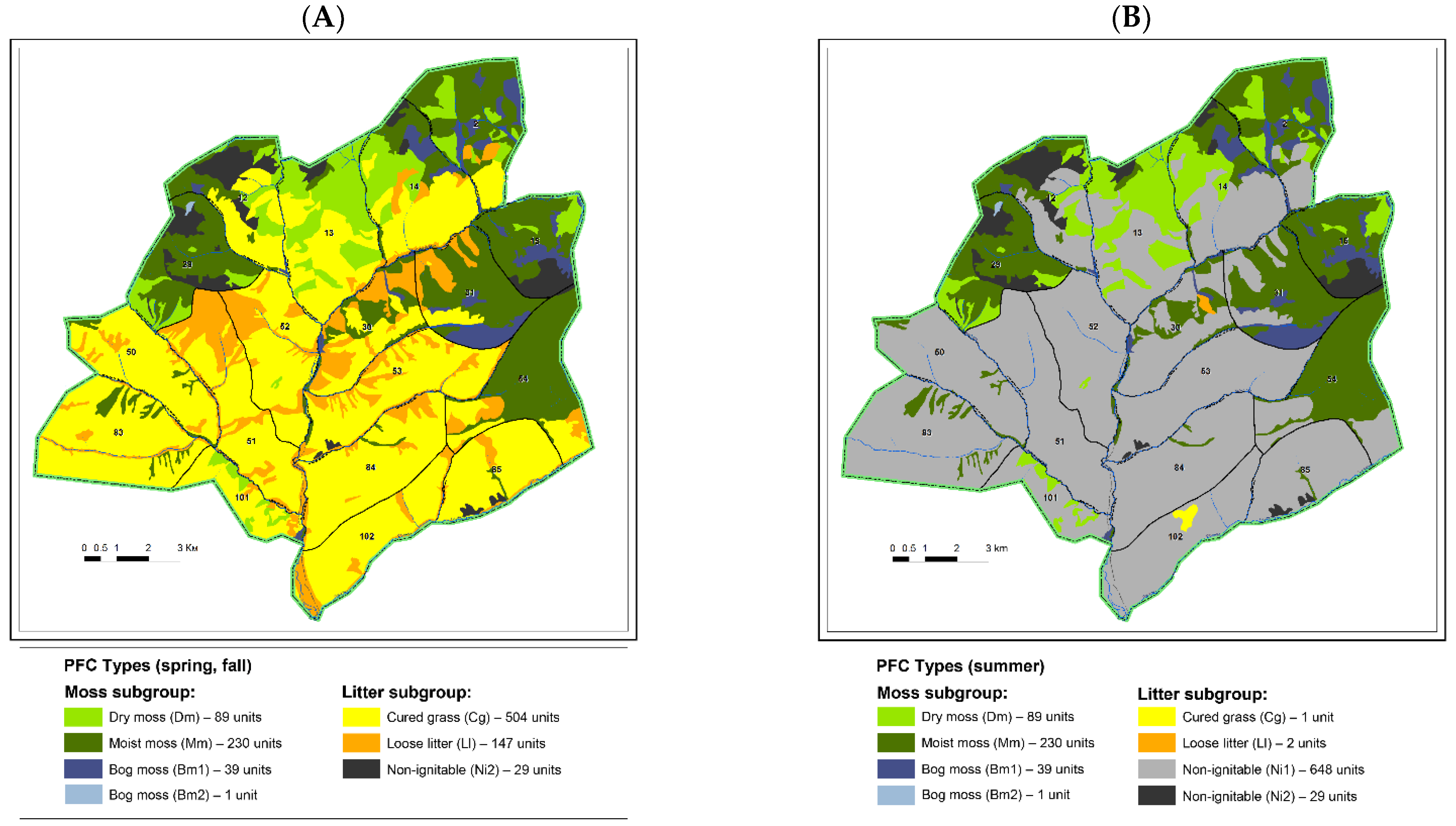
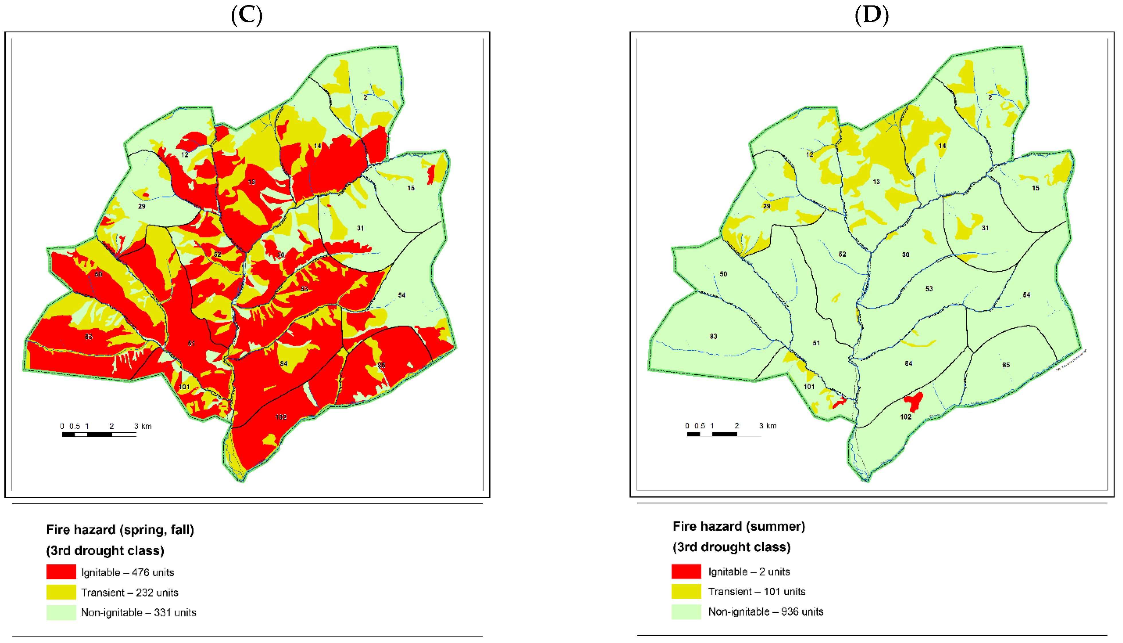
As an example, fragments of VF maps are given on the territory of the Ubsunur Hollow Nature Reserve. For this purpose, forest inventory specialists identified PFC types using the above-mentioned guide in the process of the latest forest inventory. The results were recorded in forest inventory cards and entered into the information database along with other forest inventory data. The earlier-mentioned software was used for creating large-scale VF maps based on forest inventory information [
21]. As a result, based on an individually standard method, information databases were developed for a number of nature reserves and forest office territories in Russia, located both in plain (Chunsky Forest Office of the Krasnoyarsk Territory) and mountain conditions (Stolby, Sayano-Shushensky, Kuznetsk Alatau, Ubsunur Hollow nature reserves).
As an example, we present the results of using the information database created for the territory of the Ubsunur Hollow Nature Reserve.
Figure 4 shows fragments of a large-scale VF map (1:50,000 scale; 2-m resolution) (
Figure 4A,B). Colors stand for primary fire carriers (PFC). Since the nature reserve territory belongs to the southern taiga forests with a predominance of grass forest types where PFC changes are observed during a fire season, maps are made separately for spring/fall and summer periods. In spring/fall, the cured grass PFC type (yellow) dominates with the non-ignitable type (gray) being prevalent in summer. This is explained by the fact that green grass grows in summer, its load exceeds the load of dry grass which has not decomposed yet, and the risk of fire spread is eliminated.
On the basis of VF maps, maps of current fire hazards (
Figure 4C,D) are created depending on weather conditions, or rather, on the drought class according to weather conditions. Examples are given for the 3rd drought class corresponding to 1001–3000 conventional units of the Russian fire weather index (PV1), which is calculated taking into account air temperature and dew point, as well as precipitation. The color reflects ignitability dynamics: red color stands for areas ready to support flaming combustion (ignitable), green color shows areas not ready to support flaming combustion (non-ignitable), and yellow color indicates areas in a transient state in terms of ignitability dynamics that can be clarified directly during a fire event: if flaming combustion is present on such areas, then they are all colored red on the map; if it is absent, then these areas are colored green. Such information helps fire suppression commanders make up an optimal fire suppression plan and correctly allocate manpower and means.
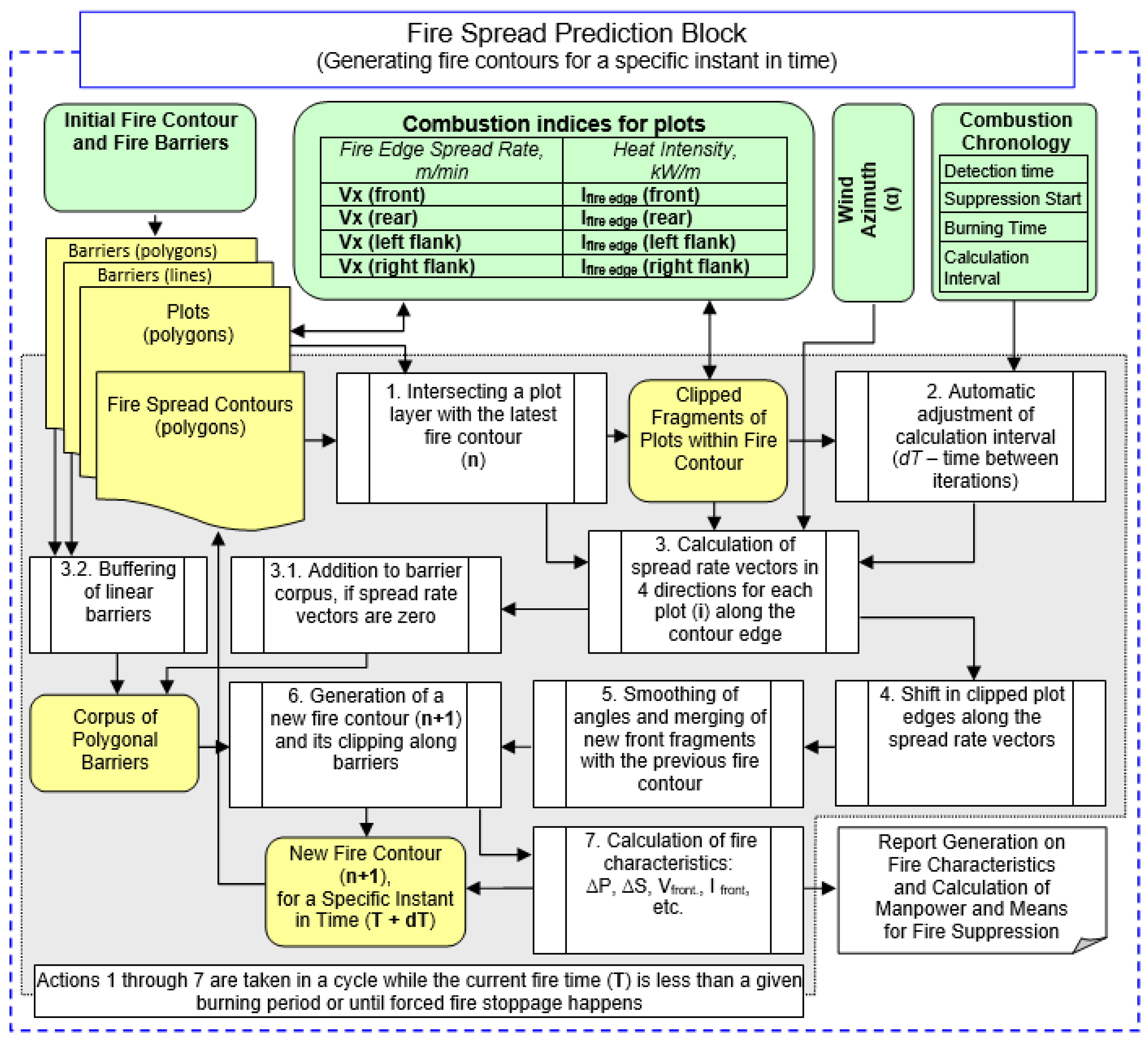
Large-scale VF maps also serve as a foundation for fire behavior prediction. For this purpose, special software was developed [
22]. Before its widespread application in firefighting practice, it was necessary to test the operation of this software in real conditions. The most accurate validation method for the proposed software is testing it on experimental fires, which is a complex and expensive undertaking. The actual number of observations on experimental fires can only be limited, and this does not ensure the statistical reliability of testing under various fire conditions. The most acceptable validation method is a retrospective performance test. However, in order to put the software into practice, the Federal Forestry Service of Russia requires field testing on active fires together with forest fire protection employees. Considering the complexity of organizing such a test on active fires and the lack of funding for applied developments at our research institute, it was decided to arrange a retrospective performance test of the software using information from past fires. The verification procedure is given in
Section 3.
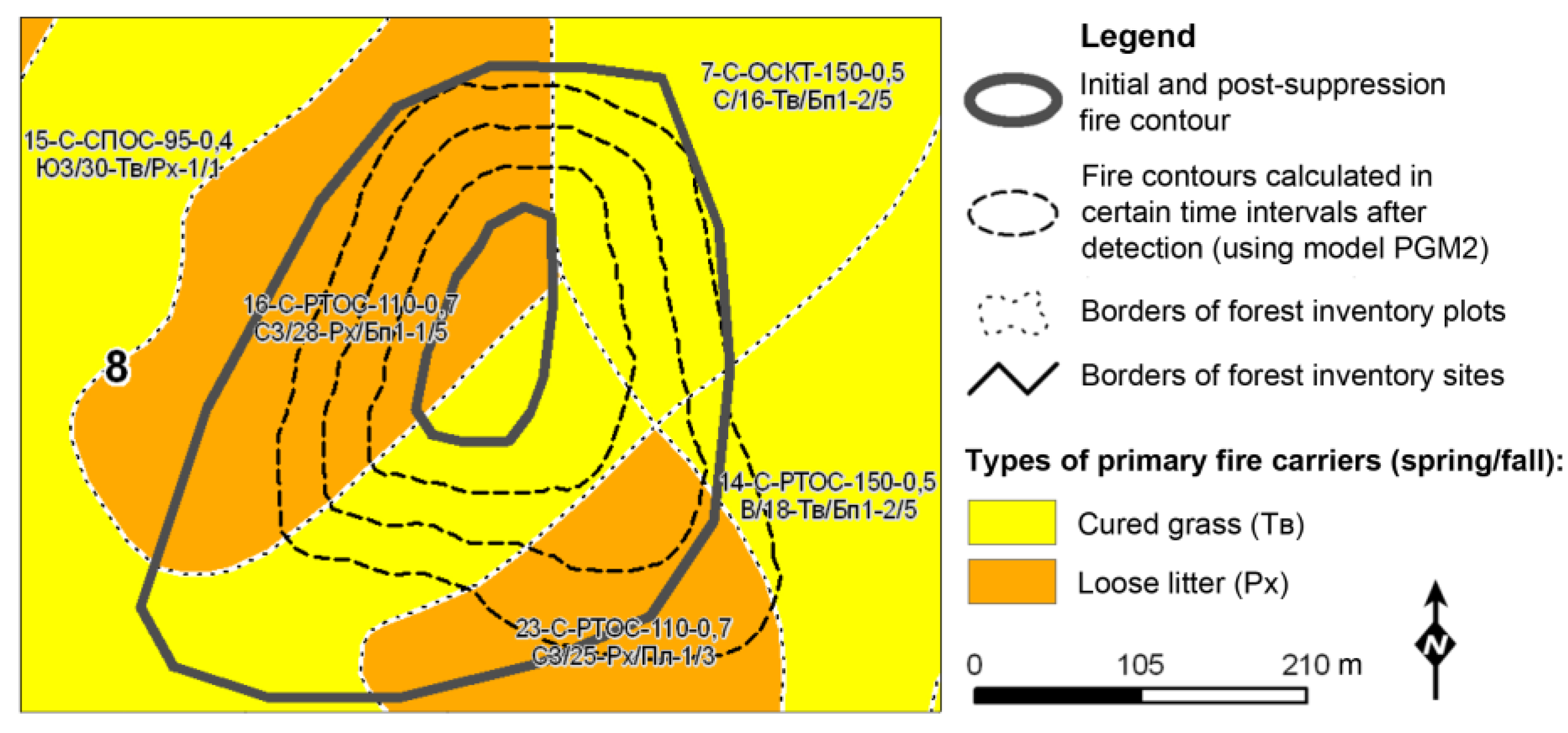
Figure 5 and
Table 2 demonstrate the software prediction of a phased spread of an occurred fire, its characteristics, and the expected burnt area after its suppression under various suppression and manpower options. The bold line indicates the initial fire contour and the final fire contour after fire suppression. The dotted lines are the calculated fire edge spread by the proposed software. The prediction almost coincides with the development of a real fire. Since suppression activities interfered with the real fire, a complete match is not observed.
5. Conclusions
The analysis of different methods of creating information databases for fire behavior prediction showed the advantage of an individually standard method developed on the basis of long-term fundamental fire science research in different regions of Russia: The White Sea and Kuloi Plateau, Western Siberia, Evenkia, Novosibirsk Oblast, Krasnoyarsk Angara Region, and Lake Baikal Basin. Ignitability dynamics were studied in different forest types, and experimental test ignitions of the fuel bed were carried out in a ring-shaped shield. This helped to further develop the pyrological classification of vegetation [
4].
Differences in methodological approaches of different countries to fire hazard assessment and fire behavior prediction are due to historical differences in the classifications of vegetation fuels that make their borrowing difficult. In addition, there are significant differences in natural conditions.
Based on an individually standard method, the presented software for large-scale VF mapping and fire behavior prediction quite objectively reflects real situations of fire spread confirmed by the results of our retrospective performance test.
A field performance test of the proposed software is planned on active wildfires in the most fire-prone region of Siberia.
The proposed individually standard method can be used in other countries since the developed classification allows one to perform a pyrological description of any part of the area, forest or non-forest.


