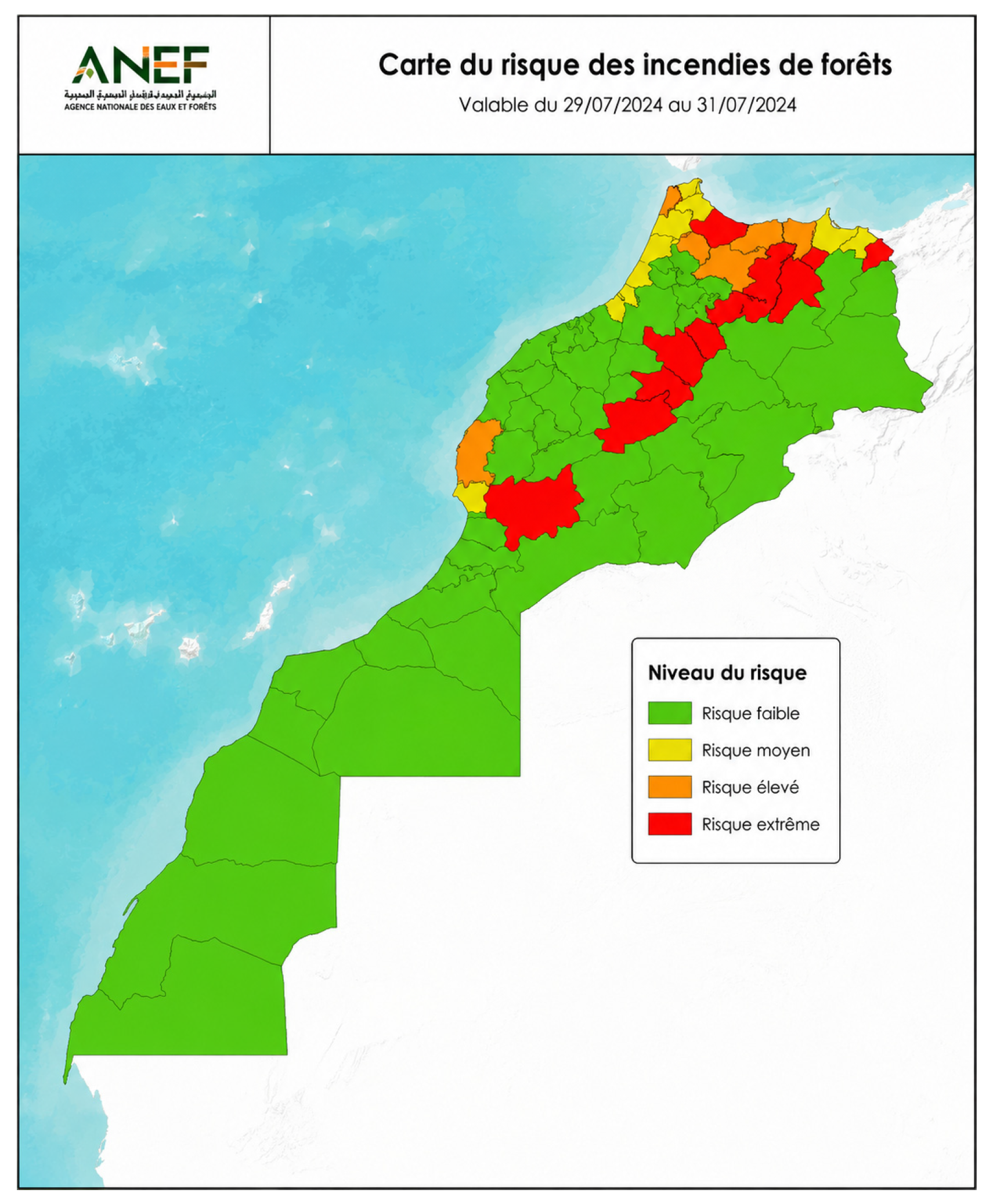
A Critical Review of Wildfire Risk Prediction Models in Data-Scarce Mediterranean Environments



Abstract
1. Introduction
2. Materials and Methods
2.1. Search Strategy and Sources
- Fire, wildfire risk assessment, forest fire prediction;
- Machine learning, XGBoost, Random Forest, LSTM, ARIMA;
- Satellite data, MODIS, NDVI, vegetation indices, drought, land use, rainfall;
- Fire spread, simulation, Cell2Fire, fire behavior models;
- Mediterranean regions, North Africa, Morocco.
2.2. Inclusion and Exclusion Criteria
- Peer-reviewed journal articles indexed in Scopus;
- Publications written in English;
- Studies published between 2014 and 2026;
- Research focusing on wildfire risk assessment, early detection, machine learning for prediction, or simulation-based prediction methods.
- Book chapters, editorials, and non-peer-reviewed sources;
- Studies targeting post-fire ecological impacts without predictive modeling;
- Articles short of methodological transparency or performance evaluation;
- Studies with highly confined hypotheses restricting suitability to other regions.
2.3. Assessment Framework
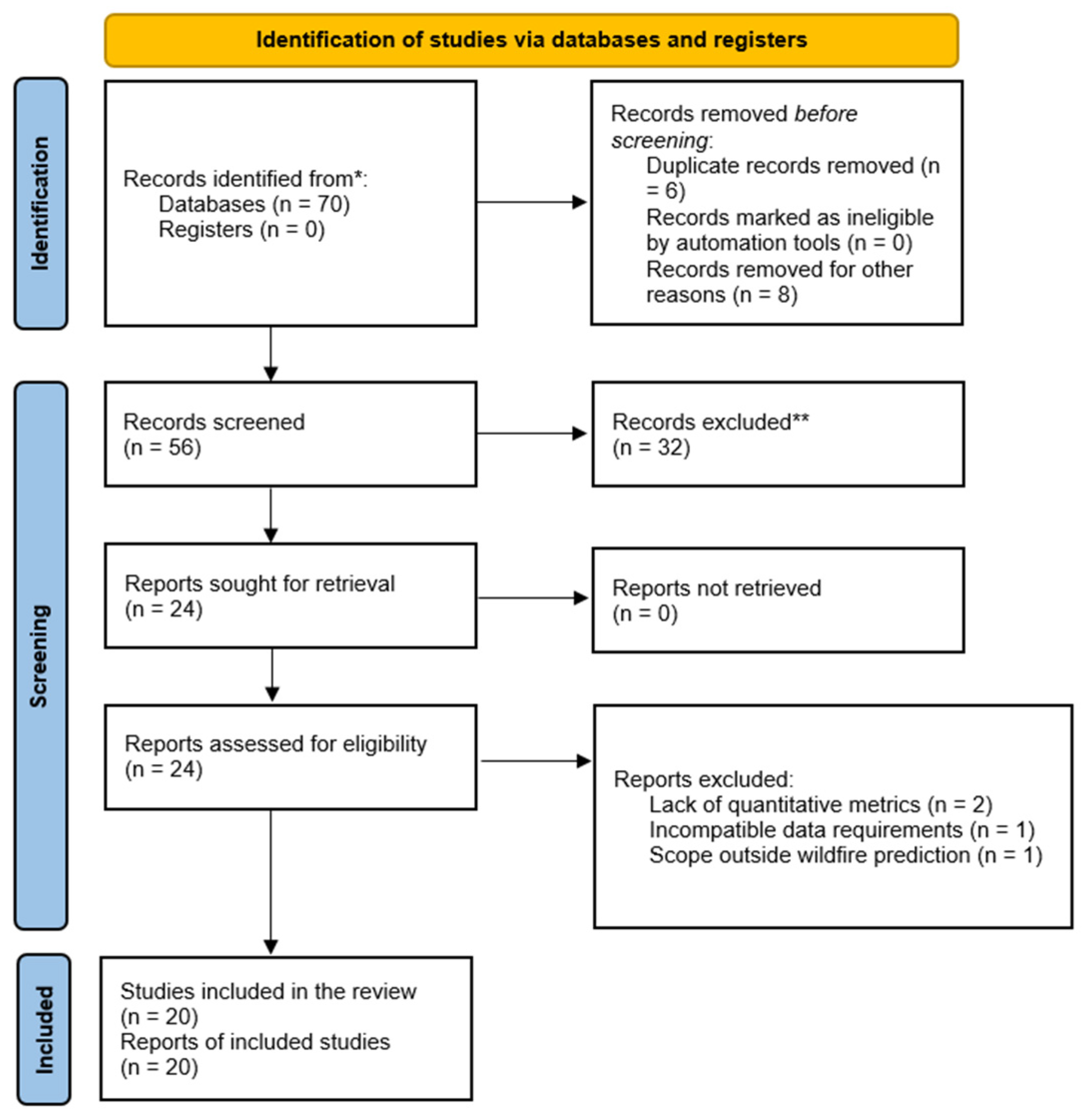
2.4. Screening and Selection Process
3. Literature Review
3.1. Ecological and Data Context in Mediterranean Environments
3.2. Overview of Prediction Models
3.2.1. Spatial Risk Mapping Models
3.2.2. Temporal and Sequential Forecasting Models
3.2.3. Satellite Data Products for Fire Monitoring
3.2.4. Fire Spread Simulation
3.3. Review of Predictive Models by Functional Category
3.3.1. Spatial Risk Mapping Models
FR-RF
XGBoost
3.3.2. Temporal Forecasting Models
ARIMA
LSTM
AttentionFire_v1.0
3.3.3. Satellite Data Products for Fire Monitoring
MODIS Data Products
3.3.4. Fire Spread Simulation
Cell2Fire
ELMFIRE
WRF-Fire
4. Discussion
4.1. Comparative Analysis of Reviewed Models
4.2. Interpretation of Key Findings
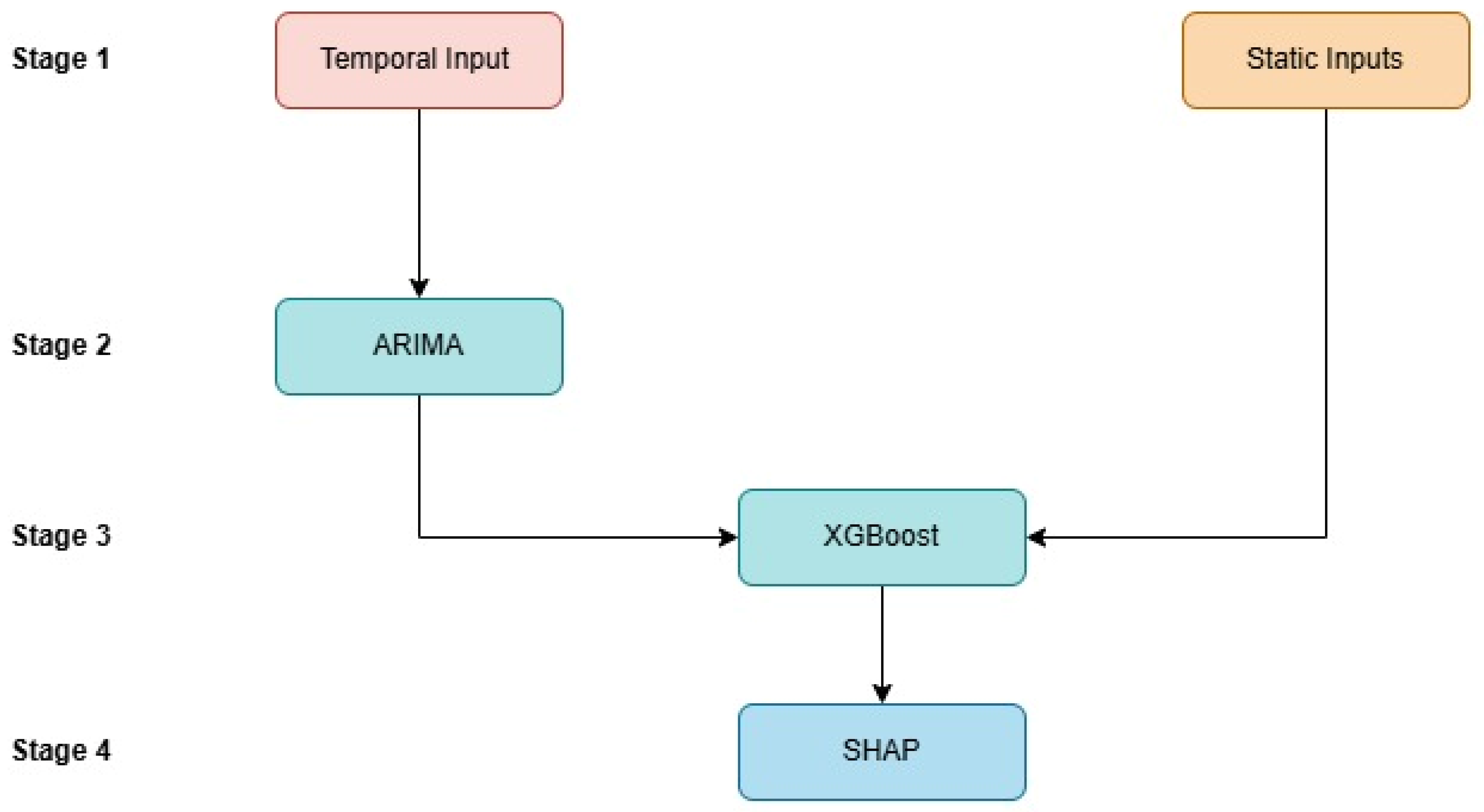
4.3. Candidate Framework for Future Investigation
5. Conclusions and Future Work
Author Contributions
Funding
Data Availability Statement
Conflicts of Interest
References
- Tatli, H.; Türkeş, M. Climatological evaluation of Haines forest fire weather index over the Mediterranean Basin. Meteorol. Appl. 2014, 21, 545–552. [Google Scholar] [CrossRef] [Scilit]
- Mohajane, M.; Costache, R.; Karimi, F.; Pham, Q.B.; Essahlaoui, A.; Nguyen, H.; Laneve, G.; Oudija, F. Application of remote sensing and machine learning algorithms for forest fire mapping in a Mediterranean area. Ecol. Indic. 2021, 129, 107869. [Google Scholar] [CrossRef] [Scilit]
- Houmma, I.H.; Hadri, A.; Boudhar, A.; El Khalki, E.M.; Karaoui, I.; Oussaoui, S.; Kinnard, C. Development of a hydrometeorological drought severity composite index based on the integration of multisource characteristics and an explainable artificial intelligence model. J. Hydrol. Reg. Stud. 2025, 61, 102623. [Google Scholar] [CrossRef] [Scilit]
- Amraoui, M.; Bouabidi, L.; El Amrani, M.; Ouakhir, H.; Dudic, B.; Lukić, T.; Spalevic, V. Land use dynamics and soil conservation strategies in the El Kssiba Region, Atlas Mountains of Morocco. Agric. For. 2024, 70, 7–27. [Google Scholar] [CrossRef] [Scilit]
- Saouita, J.; El-Hmaidi, A.; Ousmana, H.; Ragragui, H.; Aouragh, M.H.; Jaddi, H.; El Ouali, A.; Abdallaoui, A. The impact of climate change and land use on soil erosion using the RUSLE model in the Tigrigra Watershed (Azrou Region, Middle Atlas, Morocco). Sustainability 2026, 18, 1276. [Google Scholar] [CrossRef] [Scilit]
- Essaghi, S.; Hachmi, M.; Yessef, M.; Dehhaoui, M.; Sesbou, A. Litter and biomass traits of some dominant Moroccan understorey fuels in five fire-prone forest regions. Bois For. Trop. 2019, 342, 3–16. [Google Scholar] [CrossRef] [Scilit]
- Essaghi, S.; Hachmi, M.; Yessef, M.; Dehhaoui, M.; El Amarty, F. Assessment of flammability of Moroccan forest fuels: New approach to estimate the flammability index. Forests 2017, 8, 443. [Google Scholar] [CrossRef] [Scilit]
- Xu, K.; Zhao, Z.; Chen, W.; Ma, J.; Liu, F.; Zhang, Y.; Ren, Z. Comparative study on landslide susceptibility mapping based on different ratios of training samples and testing samples by using RF and FR-RF models. Nat. Hazards Res. 2024, 4, 62–74. [Google Scholar] [CrossRef] [Scilit]
- Arabameri, A.; Pradhan, B.; Rezaei, K.; Lee, C.-W. Assessment of landslide susceptibility using statistical- and artificial intelligence-based FR-RF integrated model and multiresolution DEMs. Remote Sens. 2019, 11, 999. [Google Scholar] [CrossRef] [Scilit]
- Abujayyab, S.K.M.; Karaş, İ.R.; Sevinç, H.K.; Açmali, Ş.S.; Yilmaz, M.; Dönmez, A.S.; Afnana, O. Wildfire susceptibility mapping in Karabük Province, Türkiye using machine learning algorithms. Int. Arch. Photogramm. Remote Sens. Spat. Inf. Sci. 2026, 48, 1–5. [Google Scholar] [CrossRef] [Scilit]
- Symeonidis, P.; Vafeiadis, T.; Ioannidis, D.; Tzovaras, D. Wildfire susceptibility mapping in Greece using ensemble machine learning. Earth 2025, 6, 75. [Google Scholar] [CrossRef] [Scilit]
- Teke, A.; Kavzoglu, T. Explainable artificial intelligence to unveil intrinsic characteristics of conditioning factors governing forest fire susceptibility. Int. Arch. Photogramm. Remote Sens. Spat. Inf. Sci. 2025, 48, 281–287. [Google Scholar] [CrossRef] [Scilit]
- Abd-Elhamid, H.F.; El-Dakak, A.M.; Zeleňáková, M.; Saleh, O.K.; Mahdy, M.; Abd El Ghany, S.H. Rainfall forecasting in arid regions in response to climate change using ARIMA and remote sensing. Geomat. Nat. Hazards Risk 2024, 15, 2347414. [Google Scholar] [CrossRef] [Scilit]
- Vega-Nieva, D.J.; Nava-Miranda, M.G.; Calleros-Flores, E.; López-Serrano, P.M.; Briseño-Reyes, J.; López-Sánchez, C.; Corral-Rivas, J.J.; Montiel-Antuna, E.; Cruz-Lopez, M.I.; Ressl, R.; et al. Temporal patterns of active fire density and its relationship with a satellite fuel greenness index by vegetation type and region in Mexico during 2003–2014. Fire Ecol. 2019, 15, 28. [Google Scholar] [CrossRef] [Scilit]
- Hochreiter, S.; Schmidhuber, J. Long short-term memory. Neural Comput. 1997, 9, 1735–1780. [Google Scholar] [CrossRef] [Scilit]
- Zhang, W.; Yan, H.; Xiang, L.; Shao, L. Wind power generation prediction using LSTM model optimized by sparrow search algorithm and firefly algorithm. Energy Inform. 2025, 8, 35. [Google Scholar] [CrossRef] [Scilit]
- Gao, X.; Cao, C.; Wang, S.; Xu, M.; Li, J.; Yang, X.; Yang, Y.; Hu, R.; Zhang, Y.; Wu, S.; et al. Remote sensing diagnosis of forest fire risk based on state-trend characteristics using machine learning models. Ecol. Indic. 2026, 182, 114527. [Google Scholar] [CrossRef] [Scilit]
- Li, F.; Zhu, Q.; Riley, W.J.; Zhao, L.; Xu, L.; Yuan, K.; Chen, M.; Wu, H.; Gui, Z.; Gong, J.; et al. Attention-Fire_v1.0: Interpretable machine learning fire model for burned-area predictions over tropics. Geosci. Model Dev. 2023, 16, 869–884. [Google Scholar] [CrossRef] [Scilit]
- Yan, K.; Yu, X.; Liu, J.; Wang, J.; Chen, X.; Pu, J.; Weiss, M.; Myneni, R.B. HiQ-FPAR: A high-quality and value-added MODIS global FPAR product from 2000 to 2023. Sci. Data 2025, 12, 72. [Google Scholar] [CrossRef] [Scilit]
- Cheng, J.; Zeng, Q.; Sun, H.; Yamin, G.; Yang, F.; Guo, M.; Wu, C. A global 1 km resolution daily surface longwave radiation product from MODIS satellite data from 2000–2023. Sci. Data 2025, 12, 736. [Google Scholar] [CrossRef] [Scilit]
- Pais, C.; Carrasco, J.; Martell, D.L.; Weintraub, A.; Woodruff, D.L. Cell2Fire: A cell-based forest fire growth model to support strategic landscape management planning. Front. For. Glob. Change 2021, 4, 692706. [Google Scholar] [CrossRef] [Scilit]
- Purnomo, D.M.J.; Zamanialaei, M.; Earle, M.; Theodori, M.; Qin, Y.; Lautenberger, C.; Trouvé, A.; Gollner, M. Sensitivity of ELMFIRE to real-world input datasets for WUI fire modeling. Fire Saf. J. 2026, 161, 104651. [Google Scholar] [CrossRef] [Scilit]
- Wang, Y.; Yang, C.; Shi, L.; Yao, Q.; Zhong, L. Dynamical linkages between planetary boundary layer schemes and wildfire spread processes: A case study using WRF-Fire version 4.6. Geosci. Model Dev. 2026, 19, 2059–2075. [Google Scholar] [CrossRef] [Scilit]
- George, J.; Peter, M.V.; Yadav, J.; Alapatt, B.P.; Nair, A.M.; Baby, R. Improving groundwater forecasting accuracy with a hybrid ARIMA-XGBoost approach. In Proceedings of the 2024 3rd International Conference for Advancement in Technology (ICONAT), Goa, India, 13–14 September 2024. [Google Scholar] [CrossRef] [Scilit]



| Refs. | Title | Study Region | Purpose |
|---|---|---|---|
| [1] | Climatological evaluation of Haines forest fire weather index over the Mediterranean Basin | Mediterranean Basin | Contextual Background |
| [2] | Application of remote sensing and machine learning algorithms for forest fire mapping in a Mediterranean area | Northern Morocco | Contextual Background |
| [3] | Development of a hydrometeorological drought severity composite index based on the integration of multisource characteristics and an explainable artificial intelligence model | The Oum Er Rbia watershed, Morocco | Contextual Background |
| [4] | Land Use Dynamics and Soil Conversation Strategies In The El Kssiba Region, Atlas Mountains Of Morocco | El Kssiba region of the Middle Atlas Mountains, Morocco | Contextual Background |
| [5] | The Impact of Climate Change and Land Use on Soil Erosion Using the RUSLE Model in the Tigrigra Watershed (Azrou Region, Middle Atlas, Morocco) | The Tigrigra watershed, the mountainous region of the Middle Atlas, Morocco | Contextual Background |
| [6] | Litter and biomass traits of some dominant Moroccan understorey fuels in five fire-prone forest regions | The Central Plateau, the Middle Atlas (Western and Eastern), the Western Rif and the Pre-Rif regions | Contextual Background |
| [7] | Assessment of Flammability of Moroccan Forest Fuels: New Approach to Estimate the Flammability Index | Larache, Ahl Srif, Souk L’Qolla, Dardara, Bellota | Contextual Background |
| [8] | Comparative study on landslide susceptibility mapping based on different ratios of training samples and testing samples by using RF and FR-RF models | China | Review: Spatial Risk Mapping |
| [9] | Assessment of Landslide Susceptibility Using Statistical- and Artificial Intelligence-Based FR–RF Integrated Model and Multiresolution DEMs | Iran | Review: Spatial Risk Mapping |
| [10] | Wildfire Susceptibility Mapping in Karabuk Province, Türkiye Using Machine Learning Algorithms | Turkey | Review: Spatial Risk Mapping |
| [11] | Wildfire Susceptibility Mapping in Greece Using Ensemble Machine Learning | Greece | Review: Spatial Risk Mapping |
| [12] | Explainable Artificial Intelligence to Unveil Intrinsic Characteristics of Conditioning Factors Governing Forest Fire Susceptibility | Turkey | Review: Spatial Risk Mapping |
| [13] | Rainfall forecasting in arid regions in response to climate change using ARIMA and remote sensing | Syria | Review: Temporal Forecasting |
| [14] | Temporal patterns of active fire density and its relationship with a satellite fuel greenness index by vegetation type and region in Mexico during 2003–2014 | Mexico | Review: Temporal Forecasting |
| [15] | Long short-term memory | N/A (foundational algorithm paper) | Review: Temporal Forecasting |
| [16] | Wind power generation prediction using LSTM model optimized by sparrow search algorithm and firefly algorithm | N/A | Review: Temporal Forecasting |
| [17] | Remote sensing diagnosis of Forest fire risk based on state-trend characteristics using machine learning models | China | Review: Temporal Forecasting |
| [18] | AttentionFire_v1.0: interpretable machine learning fire model for burned-area predictions over tropics | Africa and South America | Review: Temporal Forecasting |
| [19] | HiQ-FPAR: A High-Quality and Value-added MODIS Global FPAR Product from 2000 to 2023 | Global | Review: Satellite Data Products |
| [20] | A global 1 km resolution daily surface longwave radiation product from MODIS satellite data from 2000–2023 | Global | Review: Satellite Data Products |
| [21] | Cell2Fire: A cell-based forest fire growth model to support strategic landscape management planning | Canada | Review: Fire Spread Simulation |
| [22] | Sensitivity of ELMFIRE to real-world input datasets for WUI fire modeling | United States | Review: Fire Spread Simulation |
| [23] | Dynamical linkages between planetary boundary layer schemes and wildfire spread processes: A case study using WRF-Fire version 4.6 | China | Review: Fire Spread Simulation |
| [24] | Improving Groundwater Forecasting Accuracy with a Hybrid ARIMA-XGBoost Approach. | Italy | Methodological Reference |
| Model | Reported Metrics | Predictive Performance | Data Requirements | Adaptability to Low-Resource Environments |
|---|---|---|---|---|
| FR-RF | AUC = 0.931 [8]; AUC = 0.917 vs. RF AUC = 0.840 [9] | Moderate | Moderate | Moderate |
| XGBoost | Accuracy = 94.5%, AUC = 0.939, Kappa = 0.890 [10]; std-NRMSE = 0.8451 [11]; Accuracy = 81.42% [12] | High | Moderate | High |
| Model | Reported Metrics | Predictive Performance | Data Requirements | Adaptability to Low-Resource Environments |
|---|---|---|---|---|
| ARIMA | R2 > 0.75 across 6 stations [13]; R2 > 0.80 for 14/28 vegetation combinations [14] | Moderate | Low | High |
| LSTM | Accuracy = 98.5% on large wind dataset [16]; AUC = 0.63, Accuracy = 0.60 on smaller forest fire dataset [17] | Moderate | High | Low |
| AttentionFire_v1.0 | Lowest MAE among all tested models (ANN, DT, RF, GBDT, LSTM); explains 66–80% of burned area variability [18] | High | High | Low |
| Model | Reported Metrics | Predictive Performance | Data Requirements | Adaptability to Low-Resource Environments |
|---|---|---|---|---|
| Cell2Fire | Mean accuracy vs. Prometheus = 91.82%; mean 1-MSE = 91%; 30× faster than Prometheus [21] | High | High | Moderate |
| ELMFIRE | Burned area discrepancy > 50% without spatially distributed wind data [22] | High | High | Low |
| WRF-Fire | Burned area agreement = 92.82% with MODIS under best PBL scheme (MYNN3) [23] | High | High | Low |
| Model | Category | Predictive Performance | Data Requirements | Adaptability to Low-Resource Environments |
|---|---|---|---|---|
| FR-RF | Spatial Risk Mapping | Moderate | Moderate | Moderate |
| XGBoost | Spatial Risk Mapping | High | Moderate | High |
| ARIMA | Temporal Forecasting | Moderate | Low | High |
| LSTM | Temporal Forecasting | Moderate | High | Low |
| AttentionFire_v1.0 | Temporal Forecasting | High | High | Low |
| HiQ-FPAR (MODIS) | Satellite Data Products | High | Low | High |
| ELITE-MODIS SLWR | Satellite Data Products | High | Low | High |
| Cell2Fire | Fire Spread Simulation | High | High | Moderate |
| ELMFIRE | Fire Spread Simulation | High | High | Low |
| WRF-Fire | Fire Spread Simulation | High | High | Low |
Disclaimer/Publisher’s Note: The statements, opinions and data contained in all publications are solely those of the individual author(s) and contributor(s) and not of MDPI and/or the editor(s). MDPI and/or the editor(s) disclaim responsibility for any injury to people or property resulting from any ideas, methods, instructions or products referred to in the content. |
© 2026 by the authors. Licensee MDPI, Basel, Switzerland. This article is an open access article distributed under the terms and conditions of the Creative Commons Attribution (CC BY) license.
Share and Cite
Mrabet, H.; Latachi, I.; Rachidi, T.; Karim, M. A Critical Review of Wildfire Risk Prediction Models in Data-Scarce Mediterranean Environments. GeoHazards 2026, 7, 76. https://doi.org/10.3390/geohazards7020076
Mrabet H, Latachi I, Rachidi T, Karim M. A Critical Review of Wildfire Risk Prediction Models in Data-Scarce Mediterranean Environments. GeoHazards. 2026; 7(2):76. https://doi.org/10.3390/geohazards7020076
Chicago/Turabian StyleMrabet, Hajar, Ibtissam Latachi, Tajjeeddine Rachidi, and Mohammed Karim. 2026. "A Critical Review of Wildfire Risk Prediction Models in Data-Scarce Mediterranean Environments" GeoHazards 7, no. 2: 76. https://doi.org/10.3390/geohazards7020076
APA StyleMrabet, H., Latachi, I., Rachidi, T., & Karim, M. (2026). A Critical Review of Wildfire Risk Prediction Models in Data-Scarce Mediterranean Environments. GeoHazards, 7(2), 76. https://doi.org/10.3390/geohazards7020076