Mapping Flood in Endorheic Depressions Using Multitemporal and Multiresolution Remote Sensing Data—Example of Chotts Merouane and Melrhir, Algeria



Abstract
1. Introduction
2. Materials
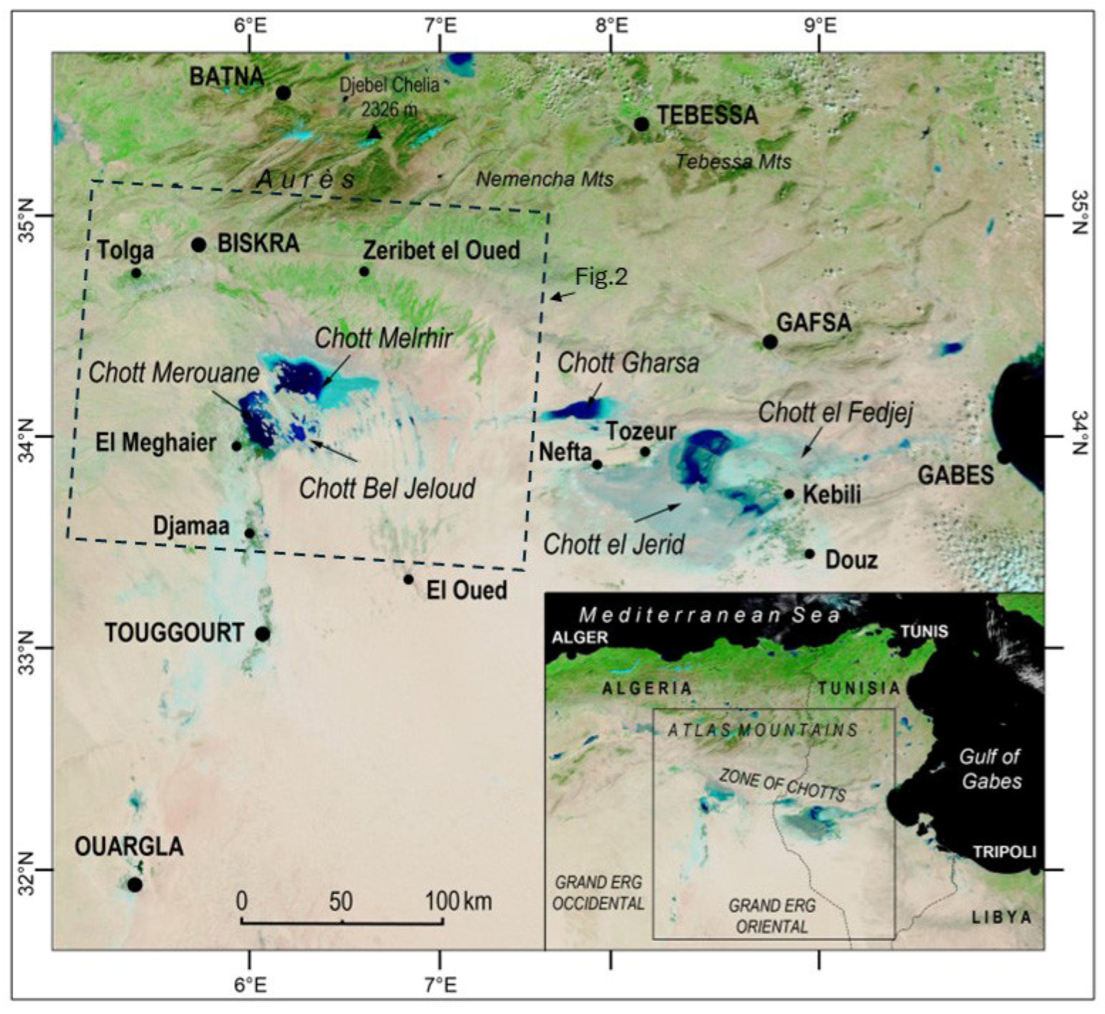
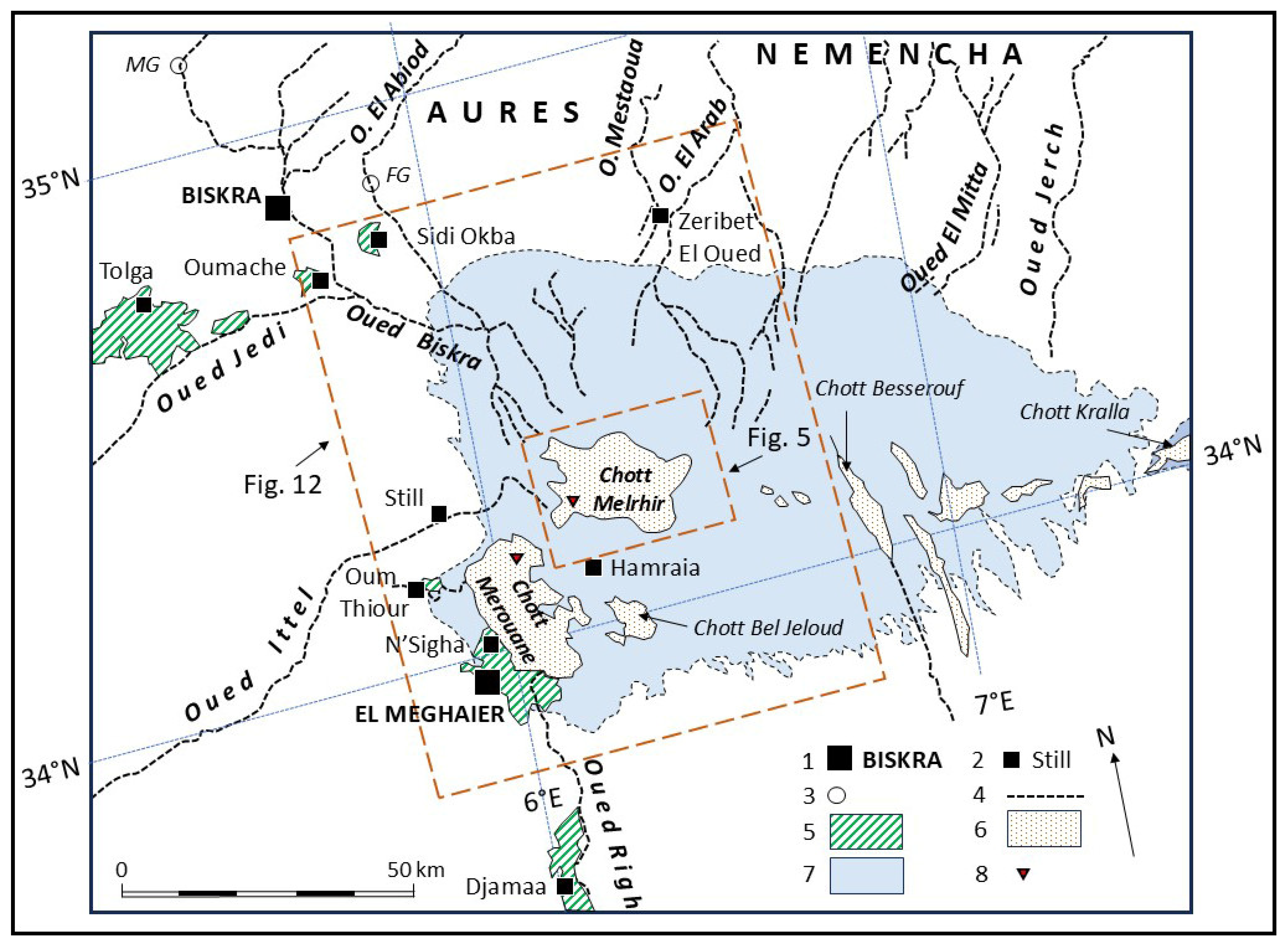
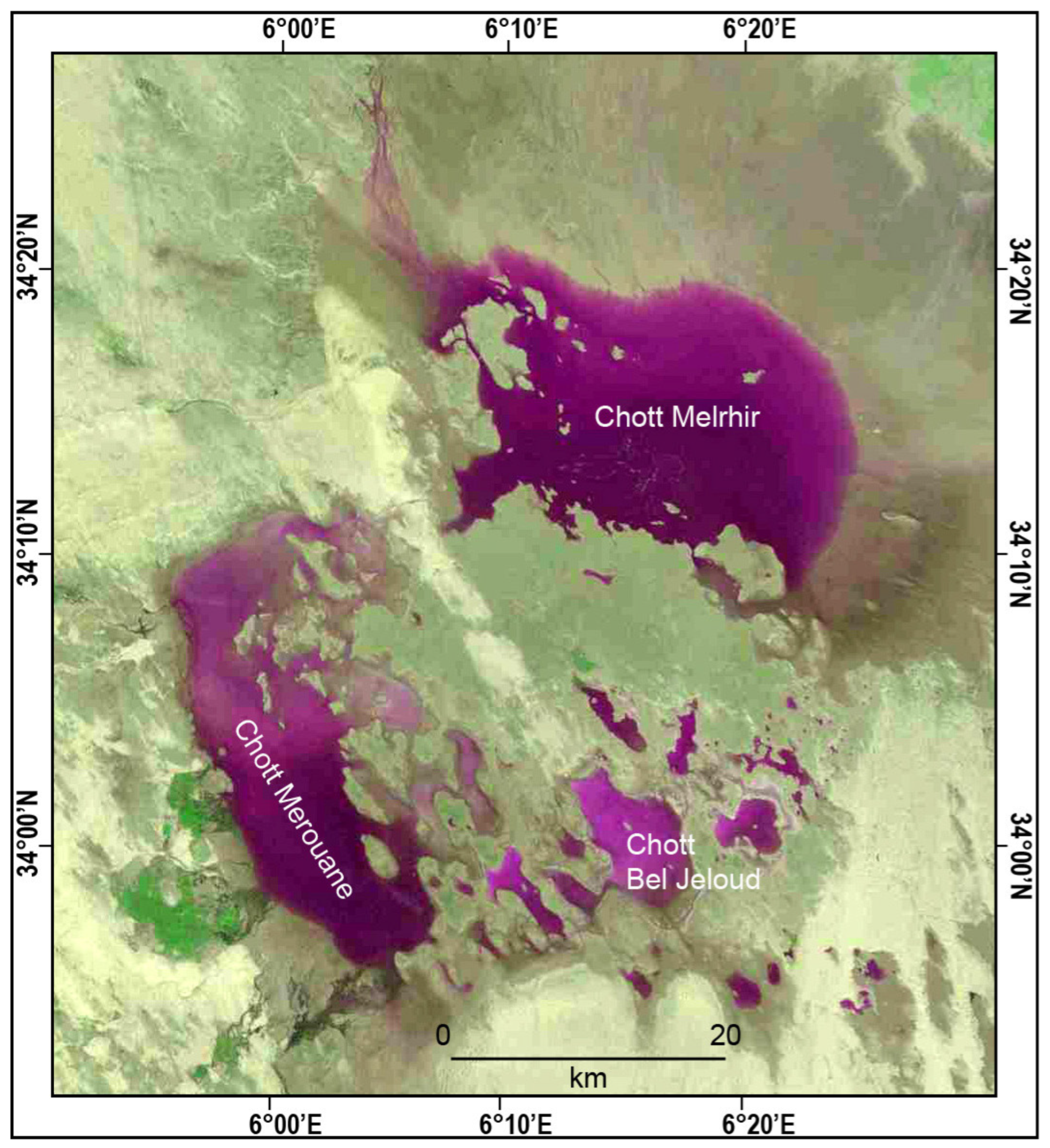
2.1. Study Site
2.2. Weather Information
2.3. Sensitivity to Floods
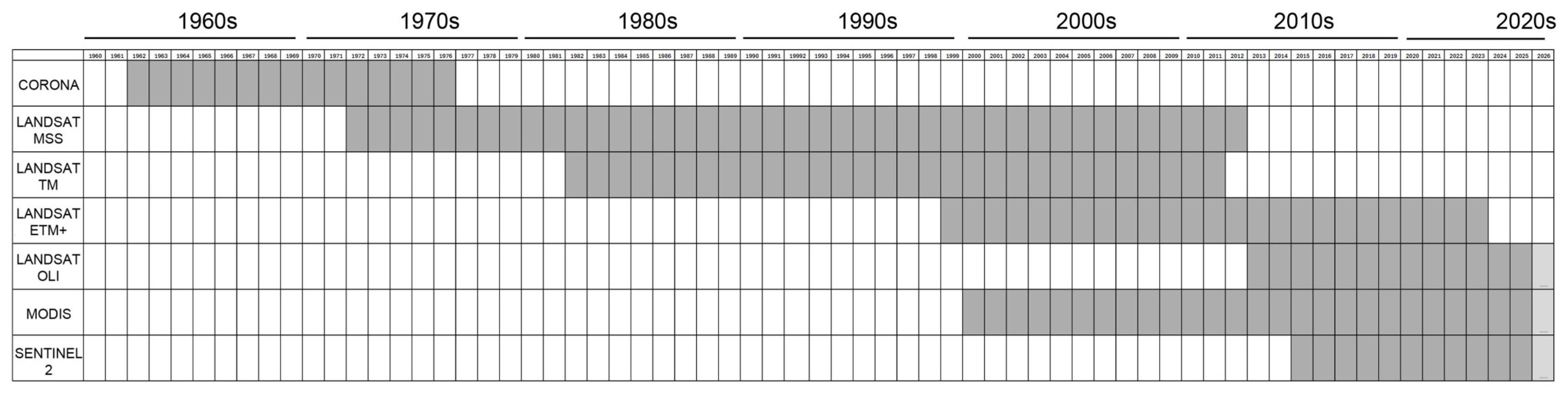
2.4. The Satellite Data
2.4.1. CORONA
2.4.2. Landsat
2.4.3. MODIS
2.4.4. Sentinel-2
3. Methods
3.1. Generalities
3.2. Processing of the Data
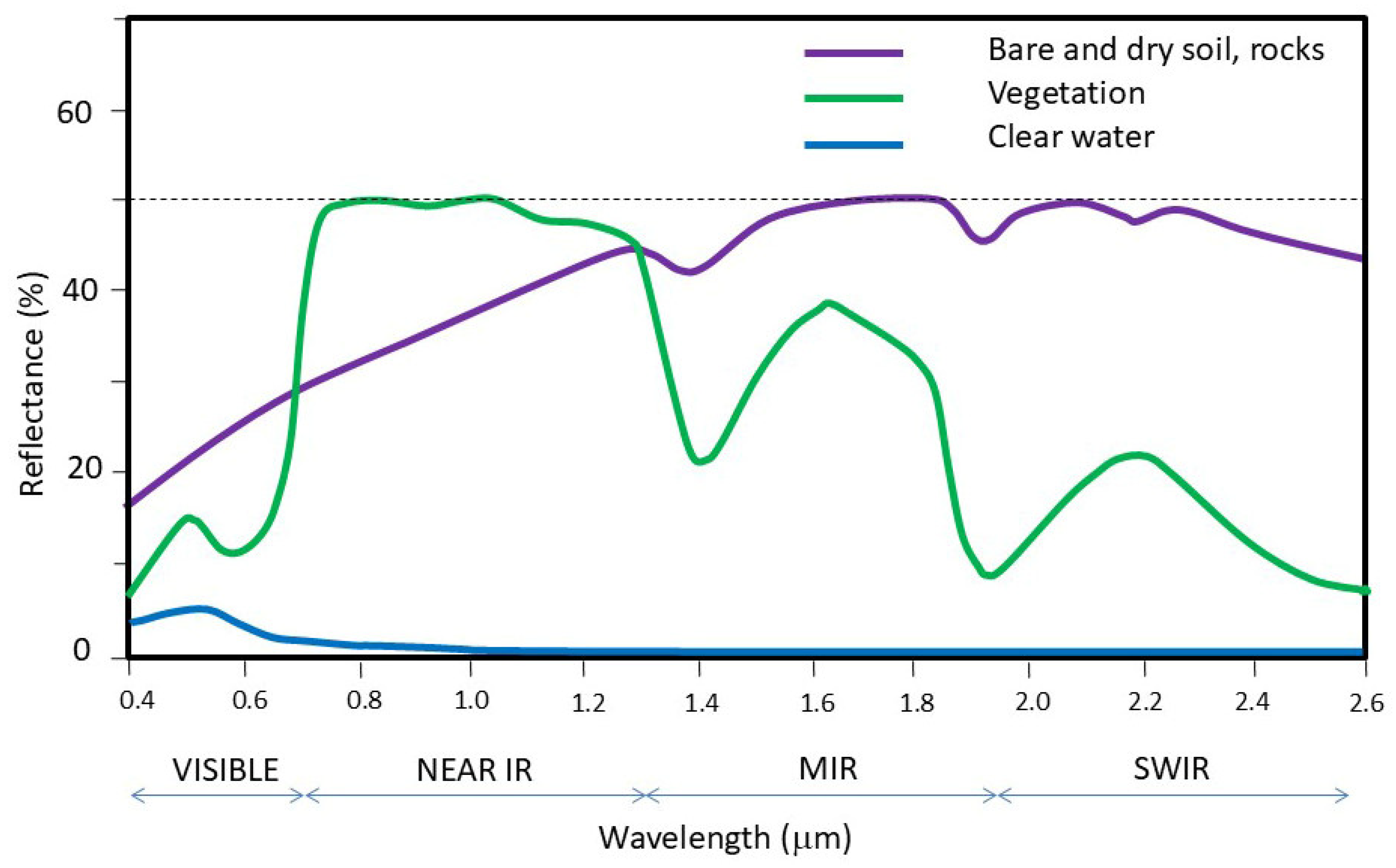
3.3. Thematic Analysis of the Satellite Data
3.3.1. MODIS Data
3.3.2. Sentinel-2
3.3.3. Climate Data
4. Results
4.1. Climate Data Analysis
4.1.1. Temperatures
4.1.2. Precipitations
4.2. Analysis of the Satellite Data (1964–2025)
4.2.1. CORONA Data
4.2.2. LANDSAT Data (Before 1994)
4.2.3. MODIS Data and LANDSAT Data
4.2.4. Sentinel-2 Data
5. Discussion
5.1. Generalities on the Remote Sensing Data Used
5.2. Interest of the Meteorological Data
5.3. Synthesis of the Landscape Changes in the Algerian Chotts
5.4. Other Worldwide Endorheic Depression Case Studies
5.5. Recommendations for Flood Hazard Mapping
6. Conclusions
- -
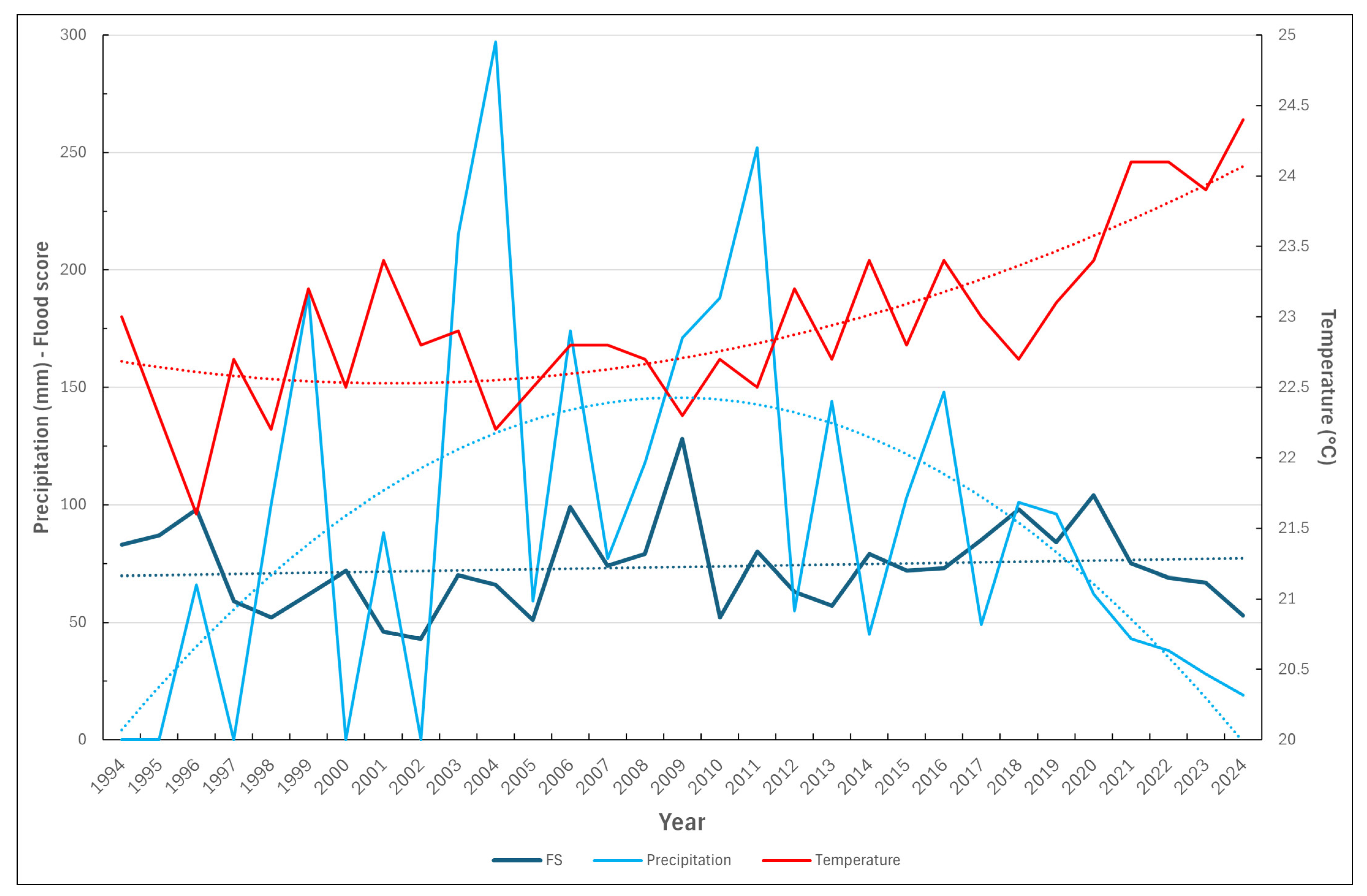
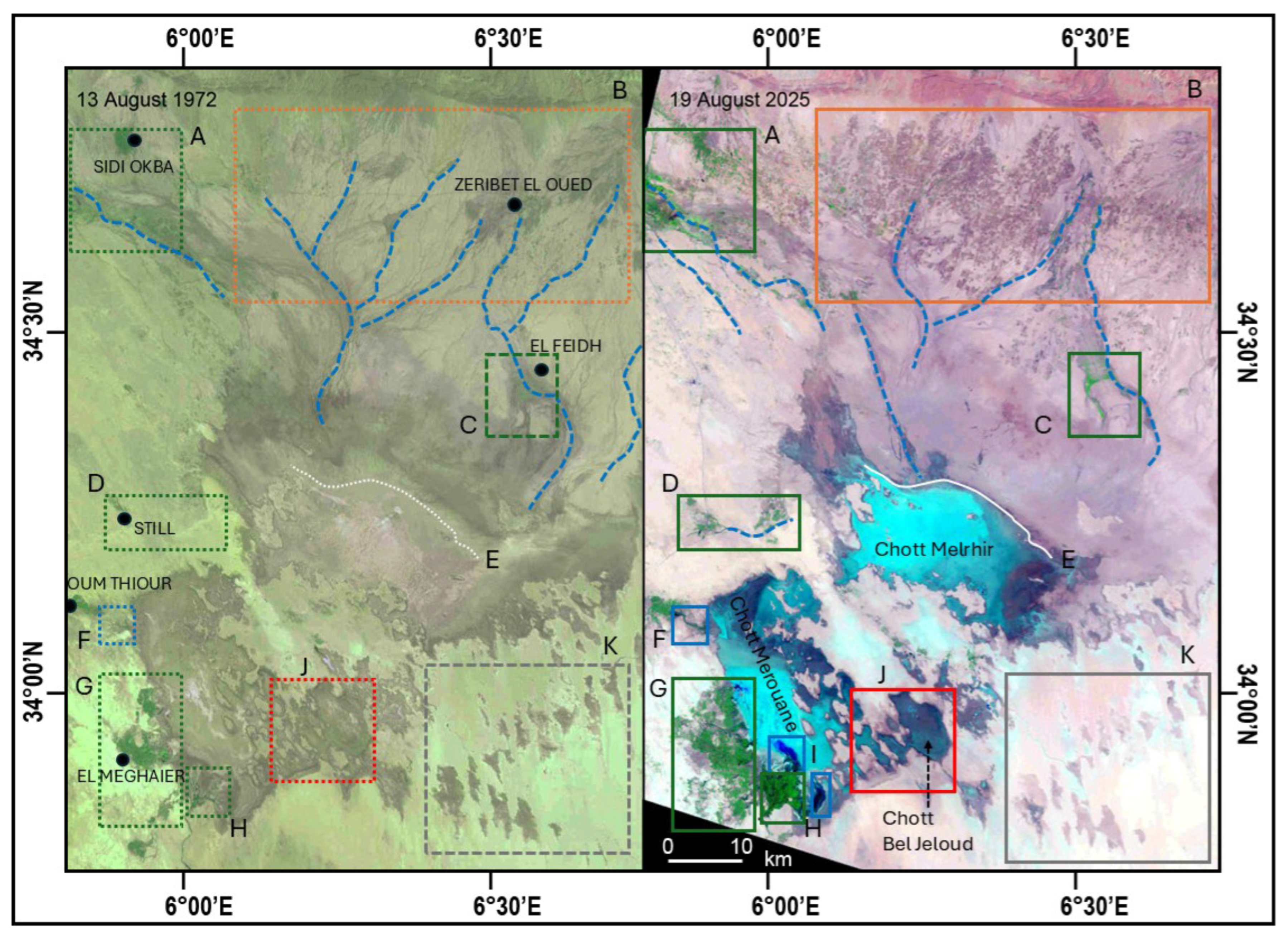
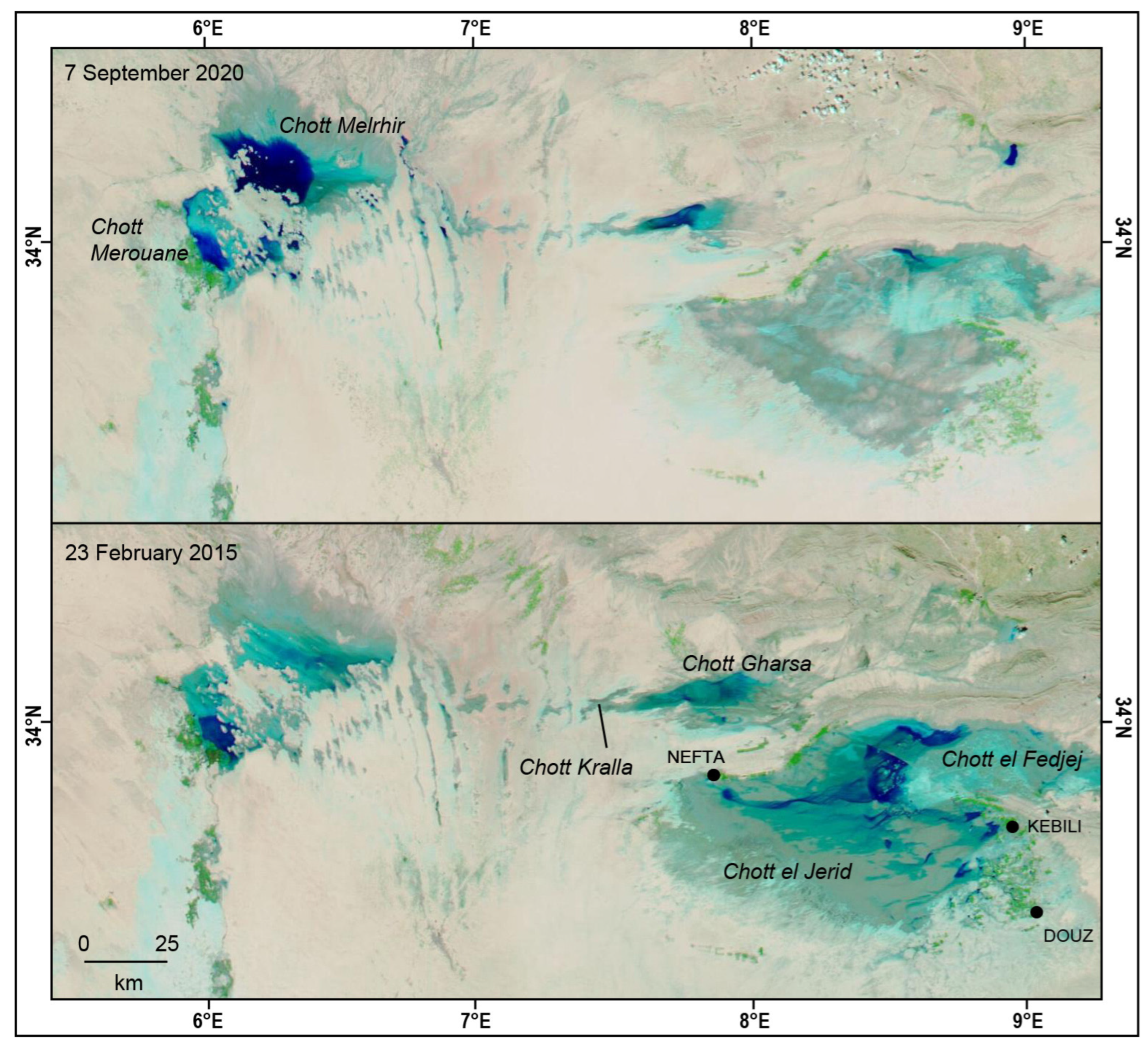
- Flood events associated with heavy rainfall are an infrequent occurrence. The majority of these events transpired within the period between 2003 and 2020. There have been no significant events since 2020, despite extremely low rainfall. This trend, and indicators of climate change in general, will require detailed analysis.
- -
- The establishment of precise links between image analyses is rendered challenging in the absence of an accurate and reliable long-term meteorological record.
- -
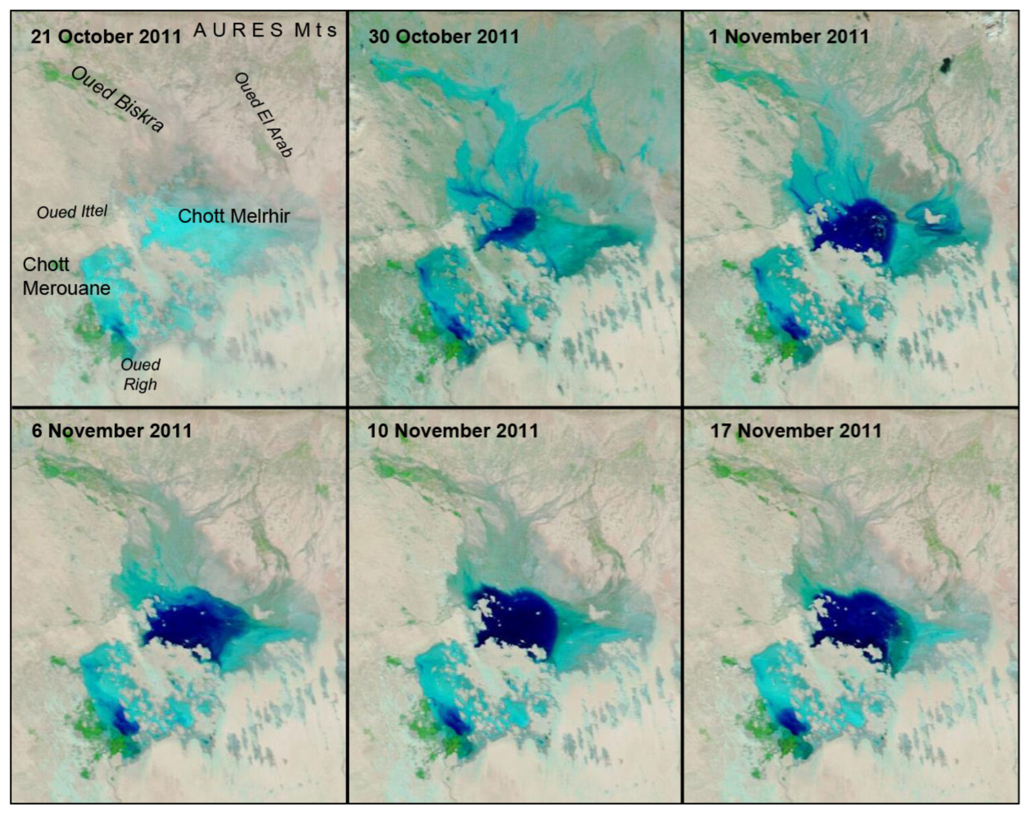
- The behaviour of Chott Melrhir is contingent on runoff from two distinct sources: first, Oued Biskra and Oued El Abiod; and second, direct runoff from the Aurès Mountains. In contrast to the situation in Chott el Jerid in Tunisia, where a spring has been observed, no such evidence has been found in this location.
- -
- Conversely, Chott Merouane is found to be significantly influenced by anthropogenic activities. An almost permanent lake is located in the southern area, at the mouth of the Oued Righ, which serves to drain the wastewater of the southern region and the oases.
- -
- It is evident that there is an absence of, or at least a paucity of, flood events emanating from the west.
- -
- Evaporites formed during significant events are principally gypsum-based. Subsequent studies will endeavour to establish a correlation with the multispectral potential of satellite imagery.
- -
- Aridification is evidenced by the development of mineral surfaces, particularly in the Chott Bel Jeloud area, and by the presence of sand veneers in the southeastern region.
Supplementary Materials
Author Contributions
Funding
Data Availability Statement
Acknowledgments
Conflicts of Interest
References
- Iacobellis, V.; Castorani, A.; Rosario di Santo, R.; Gioia, A. Rationale for flood prediction in karst endorheic areas. J. Arid Environ. 2015, 112, 98–118. [Google Scholar] [CrossRef]
- Chew, C.; Small, E. Estimating inundation extent using CYGNSS data: A conceptual modeling study. Remote Sens. Environ. 2020, 246, 111869. [Google Scholar] [CrossRef]
- Sharifi, F.; Samadi, S.Z.; Wilson, C.A.M.E. Causes and consequences of recent floods in the Golestan catchments and Caspian Sea regions of Iran. Nat. Hazards 2012, 61, 533−550. [Google Scholar] [CrossRef]
- Dezfuli, A.; Bosilovich, M.G.; Barahona, D. A dusty atmospheric river brings floods to the Middle East. Geophys. Res. Lett. 2021, 48, e2021GL095441. [Google Scholar] [CrossRef]
- Deroin, J.-P. Use of Remote Sensing Data to Study the Aral Sea Basin in Central Asia—Geoscience and Geological Hazards. Remote Sens. 2025, 17, 2814. [Google Scholar] [CrossRef]
- Ning, G.; Luo, M.; Zhang, Q.; Wang, S.; Liu, Z.; Yang, Y.; Wu, S.; Zeng, Z. Understanding the mechanisms of summer extreme precipitation events in Xinjiang of arid Northwest China. J. Geophys. Res. Atmos. 2021, 126, e2020JD034111. [Google Scholar] [CrossRef]
- Li, J.; Yang, X.; Maffei, C.; Tooth, S.; Yao, G. Applying Independent Component Analysis on Sentinel-2 Imagery to Characterize Geomorphological Responses to an Extreme Flood Event near the Non-Vegetated Río Colorado Terminus, Salar de Uyuni, Bolivia. Remote Sens. 2018, 10, 725. [Google Scholar] [CrossRef]
- Lemoalle, J.; Bader, J.C.; Leblanc, M.; Sedick, A. Recent changes in Lake Chad: Observations, simulations and management options (1973–2011). Glob. Planet. Change 2012, 80–81, 247−254. [Google Scholar] [CrossRef]
- Deroin, J.-P. Permian and Quaternary playas, a discussion based on climatic, tectonic and palaeogeographic settings. J. Iber. Geol. 2008, 34, 11−28. [Google Scholar]
- Xiao, Y.; Zhang, Y.; Yang, H.; Wang, L.; Han, J.; Hao, Q.; Wang, J.; Zhao, Z.; Hu, W.; Wang, S.; et al. Interaction regimes of surface water and groundwater in a hyper-arid endorheic watershed on Tibetan Plateau: Insights from multi-proxy data. J. Hydrol. 2024, 644, 132020. [Google Scholar] [CrossRef]
- Benziouche, S.E.; Chehat, F. Irrigation problem in Ziban oases (Algeria): Causes and consequences. Environ. Dev. Sustain. 2019, 21, 2693–2706. [Google Scholar] [CrossRef]
- Boumaraf, B. Caractéristiques et Fonctionnement des Sols dans la Vallée d’Oued Righ, Sahara Nord-Oriental, Algérie. Ph.D. Thesis, Université de Reims Champagne-Ardenne, Reims, France, 2013; pp. 1–108. [Google Scholar]
- Khatei, G.; Rinaldo, T.; Van Pelt, R.S.; D’Odorico, P.; Ravi, S. Wind erodibility and particulate matter emissions of salt-affected soils: The case of dry soils in a low humidity atmosphere. J. Geophys. Res. Atmos. 2024, 129, e2023JD039576. [Google Scholar] [CrossRef]
- Jerez, B.; Garcés, I.; Torres, R. Lithium extractivism and water injustices in the Salar de Atacama, Chile: The colonial shadow of green electromobility. Polit. Geogr. 2021, 87, 102382. [Google Scholar] [CrossRef]
- Benameur, S.; Benkhaled, A.; Meraghni, D.; Chebana, F.; Necir, A. Complete flood frequency analysis in Abiod watershed, Biskra (Algeria). Nat. Hazards 2017, 86, 519–534. [Google Scholar] [CrossRef]
- Azioune, R.; Tatar, H.; Nouaceur, Z. Pluies extrêmes et risque d’inondation dans la ville de Biskra (Algérie). Sci. Technol. D Sci. Terre 2018, 48, 93–106. [Google Scholar]
- Fathalli, B.; Castel, T.; Pohl, B. Simulated effects of land immersion on regional arid climate: A case study of the pre-Saharan playa of Chott el-Jerid (south of Tunisia). Theor. Appl. Climatol. 2020, 140, 231–250. [Google Scholar] [CrossRef]
- Afrasinei, G.M.; Melis, M.T.; Buttau, C.; Bradd, J.M.; Arras, C.; Ghiglieri, G. Assessment of remote sensing-based classification methods for change detection of salt-affected areas (Biskra area, Algeria). J. Appl. Remote Sens. 2017, 11, 016025. [Google Scholar] [CrossRef]
- Abbas, K.; Deroin, J.P.; Bouaziz, S. Monitoring of playa evaporites as seen with optical remote sensing sensors: Case of Chott El Jerid, Tunisia, from 2003 to present. Arab. J. Geosci. 2017, 11, 92. [Google Scholar] [CrossRef]
- Lemenkova, P. A GRASS GIS Scripting Framework for Monitoring Changes in the Ephemeral Salt Lakes of Chotts Melrhir and Merouane, Algeria. Appl. Syst. Innov. 2023, 6, 61. [Google Scholar] [CrossRef]
- Radwan, N.; Halder, B.; Ahmed, M.F.; Refadah, S.S.; Khan, M.Y.A.; Scholz, M.; Sammen, S.S.; Pande, C.B. Seasonal Precipitation and Anomaly Analysis in Middle East Asian Countries Using Google Earth Engine. Water 2025, 17, 1475. [Google Scholar] [CrossRef]
- Alarifi, S.S.; Abdelkareem, M.; Abdalla, F.; Alotaibi, M. Flash Flood Hazard Mapping Using Remote Sensing and GIS Techniques in Southwestern Saudi Arabia. Sustainability 2022, 14, 14145. [Google Scholar] [CrossRef]
- Jemai, S.; Belkendil, A.; Kallel, A.; Ayadi, I. Assessment of flood risk using Hierarchical Analysis Process method and Remote Sensing systems through arid catchment in southeastern Tunisia. J. Arid Environ. 2024, 222, 105150. [Google Scholar] [CrossRef]
- Hidayatulloh, A.; Bahrawi, J.; Psilovikos, A.; Elhag, M. Integrating MCDA and Rain-on-Grid Modeling for Flood Hazard Mapping in Bahrah City, Saudi Arabia. Geosciences 2026, 16, 32. [Google Scholar] [CrossRef]
- Al-Ruzouq, R.; Shanableh, A.; Jena, R.; Gibril, M.B.A.; Hammouri, N.A.; Lamghari, F. Flood susceptibility mapping using a novel integration of multi-temporal sentinel-1 data and eXtreme deep learning model. Geosci. Front. 2024, 15, 101780. [Google Scholar] [CrossRef]
- Shawky, M.; Hassan, Q.K. Geospatial Modeling Based-Multi-Criteria Decision-Making for Flash Flood Susceptibility Zonation in an Arid Area. Remote Sens. 2023, 15, 2561. [Google Scholar] [CrossRef]
- Mashaly, J.; Ghoneim, E. Flash Flood Hazard Using Optical, Radar, and Stereo-Pair Derived DEM: Eastern Desert, Egypt. Remote Sens. 2018, 10, 1204. [Google Scholar] [CrossRef]
- Bouamrane, A.; Derdous, O.; Dahri, N.; Tachi, S.E.; Boutebba, K.; Bouziane, M.T. A Comparison of the Analytical Hierarchy Process and the Fuzzy Logic Approach for Flood Susceptibility Mapping in a Semi-Arid Ungauged Basin (Biskra Basin: Algeria). Int. J. River Basin Manag. 2020, 20, 203–213. [Google Scholar] [CrossRef]
- Afra, A.; Berrezel, Y.A.; Abdelbaki, C.; Megnounif, A.; Saber, M.; Benabdelkrim, M.E.A.; Kumar, N. Application of the Rainfall–Runoff–Inundation Model for Flood Risk Assessment in the Mekerra Basin, Algeria. GeoHazards 2025, 6, 2. [Google Scholar] [CrossRef]
- Abdelkareem, M.; Mansour, A.M. Risk assessment and management of vulnerable areas to flash flood hazards in arid regions using remote sensing and GIS-based knowledge-driven techniques. Nat. Hazards 2023, 117, 2269–2295. [Google Scholar] [CrossRef]
- Al Saodi, R.; Al Kuisi, M.; Al Salaymeh, A. Assessing the vulnerability of flash floods to climate change in arid zones: Amman–Zarqa Basin, Jordan. J. Water Clim. Change 2023, 14, 4376. [Google Scholar] [CrossRef]
- Boutouga, F. Ressources et Essai de Gestion des Eaux dans le Zab Est de Biskra. Ph.D. Thesis, University Badji Mokhtar-Annaba, Annaba, Algeria, 2012; pp. 1–172. [Google Scholar]
- Subraelu, P.; Ahmed, A.; Ebraheem, A.A.; Sherif, M.; Mirza, S.B.; Ridouane, F.L.; Sefelnasr, A. Risk Assessment and Mapping of Flash Flood Vulnerable Zones in Arid Region, Fujairah City, UAE-Using Remote Sensing and GIS-Based Analysis. Water 2023, 15, 2802. [Google Scholar] [CrossRef]
- Ballais, J.L.; Ben Ouezdou, H. Forms and deposits of the Continental Quaternary of the Saharan margin of Eastern Maghreb (tentative synthesis). J. Afr. Earth Sci. 1991, 12, 209–216. [Google Scholar] [CrossRef]
- Demnati, F.; Samraoui, B.; Allache, F.; Sandoz, A.; Ernoul, L. A literature review of Algerian salt lakes: Values, threats and implications. Environ. Earth Sci. 2017, 76, 127. [Google Scholar] [CrossRef]
- Hacini, M.; Kherici, N.; Oelkers, E.H. Mineral precipitation rates during the complete evaporation of the Merouane Chott ephemeral lake. Geochim. Cosmochim. Acta 2009, 72, 1583–1597. [Google Scholar] [CrossRef]
- Kottec, M.; Grieser, J.; Beck, C.; Rudolf, B.; Rubel, F. World Map of Köppen-Geiger climate classification. Meteorol. Z. 2006, 15, 259–263. [Google Scholar] [CrossRef] [PubMed]
- McFeeters, S.K. The use of the Normalized Difference Water Index (NDWI) in the delineation of open water features. Int. J. Remote Sens. 1996, 17, 1425–1432. [Google Scholar] [CrossRef]
- Bryant, R.G.; Rainey, M.P. Investigation of flood inundation on playas within the Zone of Chotts, using a time-series of AVHRR. Remote Sens. Environ. 2002, 82, 360–375. [Google Scholar] [CrossRef]
- Ogilvie, A.; Belaud, G.; Massuel, S.; Mulligan, M.; Le Goulven, P.; Malaterre, P.O.; Calvez, R. Combining Landsat observations with hydrological modelling for improved surface water monitoring of small lakes. J. Hydrol. 2018, 566, 109–121. [Google Scholar] [CrossRef]
- Abd Ellah, R.G. Morphometric analysis of Toshka Lakes in Egypt: A succinct review of geographic information systems & remote sensing based techniques. Egypt. J. Aquat. Res. 2021, 47, 215–221. [Google Scholar] [CrossRef]
- Chihi, H.; Hammami, M.A.; Mezni, I. Flood susceptibility mapping in data-scarce arid environments: Guided by geology-driven knowledge and multi-event cloud-based validation. Nat. Hazards 2025, 121, 20855–20901. [Google Scholar] [CrossRef]
- Botey i Bassols, J.; Bedia, C.; Cuevas-González, M.; Valdivielso, S.; Crosetto, M.; Vázquez-Suñé, E. Evaluating the Uncertainty in Coherence-Change-Detection-Based Maps of Torrential Sediment Transport in Arid Environments. Remote Sens. 2023, 15, 4964. [Google Scholar] [CrossRef]
- Botey i Bassols, J.; Bedia, C.; Cuevas-González, M.; Valdivielso, S.; Crosetto, M.; Vázquez-Suñé, E. SAR Coherence in Detecting Fluvial Sediment Transport Events in Arid Environments. Remote Sens. 2023, 15, 3034. [Google Scholar] [CrossRef]
- Flahaut, J.; Martinot, M.; Bishop, J.L.; Davies, G.R.; Potts, N.J. Remote sensing and in situ mineralogic survey of the Chilean salars: An analog to Mars evaporate deposits? Icarus 2017, 282, 152–173. [Google Scholar] [CrossRef]
- Radwin, M.H.; Bowen, B.B. Mapping mineralogy in evaporite basins through time using multispectral Landsat data: Examples from the Bonneville basin, Utah, USA. Earth Surf. Process. Landf. 2021, 46, 1160–1176. [Google Scholar] [CrossRef]
- Abbas, K. Suivi par Télédétection Multi-Source du Bassin Endoréique du Chott El Djérid (Tunisie) Entre 1985 et 2015. Ph.D. Thesis, University of Reims, Reims, France, 2016; pp. 1–281. [Google Scholar]
- Mihi, A.; Tarai, N.; Chenchouni, H. Can palm date plantations and oasification be used as a proxy to fight sustainably against desertification and sand encroachment in hot drylands? Ecol. Indic. 2019, 105, 365–375. [Google Scholar] [CrossRef]
- Daich, S.; Saadi, M.Y.; Santoro, A.; Piras, F.; Boumaraf, B. Spatiotemporal analysis, monitoring, and future prediction of land use/land cover changes in Ghouts: A sustainable agricultural system in the El Oued Oases, Algeria. Environ. Monit. Assess. 2025, 197, 1062. [Google Scholar] [CrossRef]



| Scene Data | Corona | Landsat | Modis | Sentinel 2 |
|---|---|---|---|---|
| 1. Selection | limited choice | <…cloud- | free | images…> |
| 2. Available period | 1962–1970 | 1972–2026 | 2000–2026 | 2015–2026 |
| 3. Download (website) | USGS | USGS | Modis | Copernicus |
| 4. Image nature | PAN | PAN or XS | XS | XS |
| 5. Orthorectification | N/A | Yes | N/A | Yes |
| 6. Resolution/resampling | 1.8 to 140 m | 15 to 80 m | 250 m | 10 or 20 m |
| 7. Atmospheric correction | no | yes, TOA | yes, TOA | yes, BOA |
| 8. Colour composite | N/A | MSS RGB = 754 | RGB = 721 | RGB = 8-11-12 |
| Red = NIR2 | Red = SWIR | Red = NIR | ||
| Green = Red | Green = NIR | Green = MIR | ||
| Blue = Green | Blue = Red | Blue = SWIR | ||
| 9. Inclusion in data base | No | Partly | Yes | Partly |
| 10. Flood events detected | Yes | Yes | Yes | Yes |
| 11. Flood events surveyed | No | No | Yes | Yes |
| Repetititivity | random | 16–18 days | 1 day | 3–5 days |
| 12. Waterbody extraction | N/A | N/A | Visual interp. | Thresholding |
| 13. Quantification of the | N/A | N/A | 0 to 5 | Reg. of interest |
| water bodies | 0 to 100% | Surface in km2 |
| Biskra (DZ) | El Oued (DZ) | Touggourt (DZ) | Ouargla (DZ) | Tozeur (TN) | |
|---|---|---|---|---|---|
| Temperature (°C) | |||||
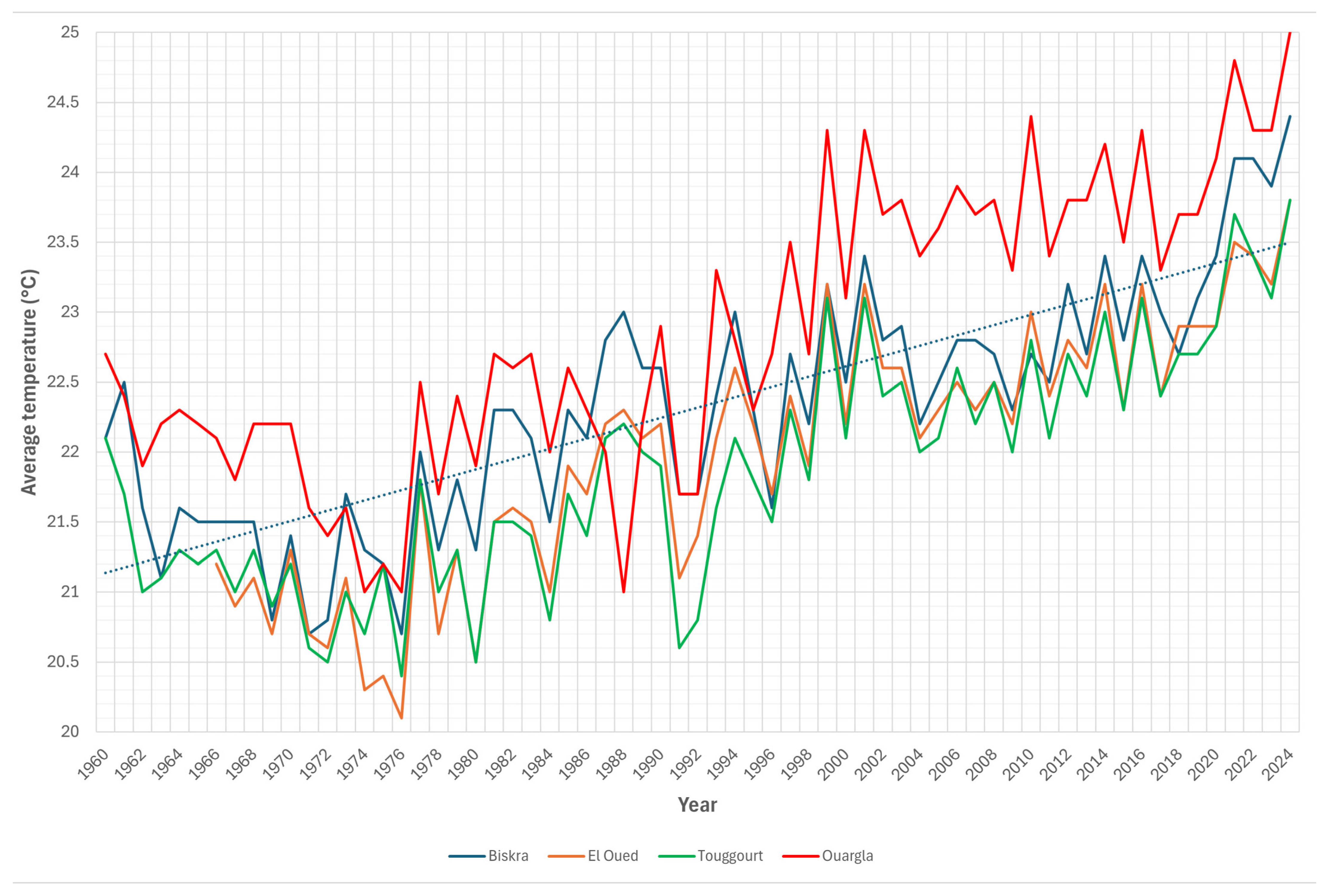
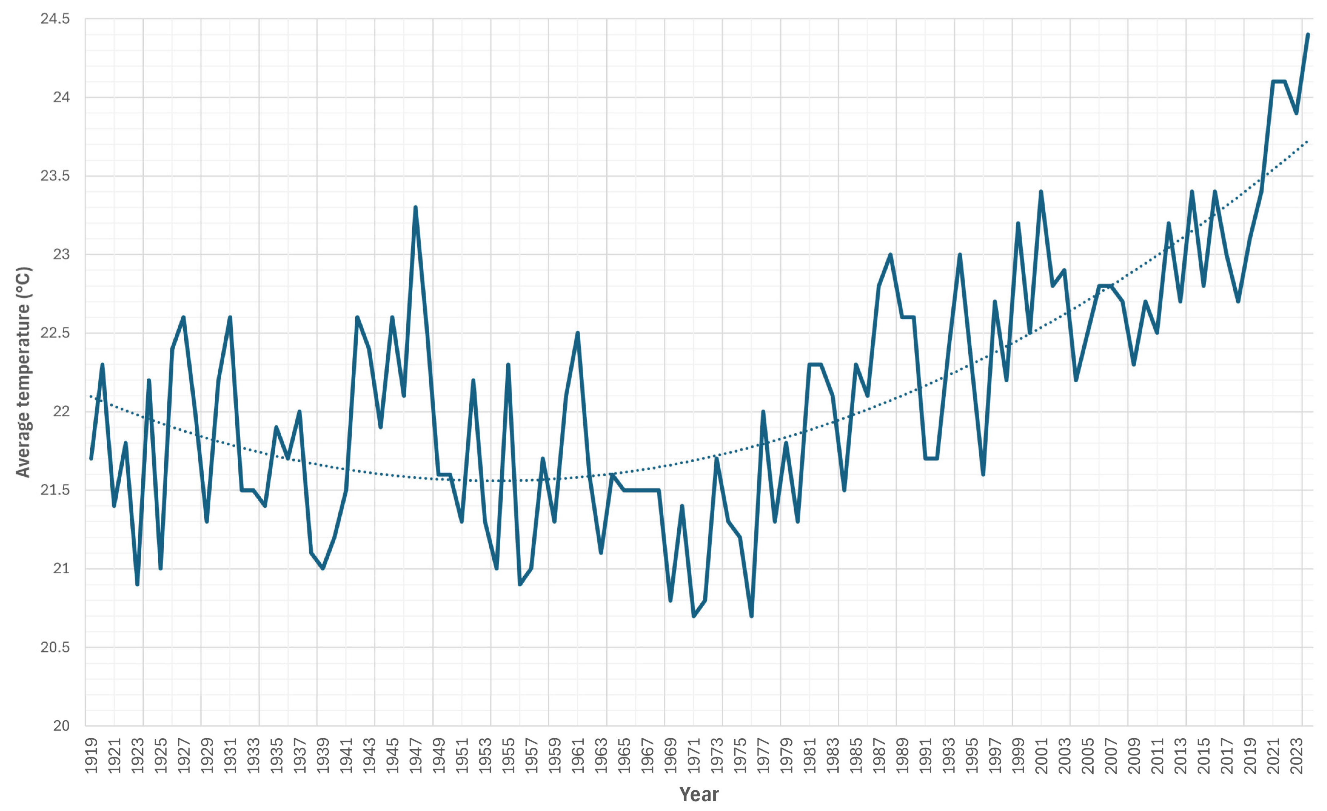
| Period (1960–2024) | 22.32 ± 0.86 | 22.01 ± 0.91 | 21.87 ± 0.84 | 22.86 ± 1.02 | 22.14 ± 0.75 |
| Period (1960–1989) | 21.70 ± 0.62 | 21.19 ± 0.62 | 21.26 ± 0.49 | 22.02 ± 0.51 | 21.57 ± 0.43 |
| Period (1990–2024) | 22.85 ± 0.66 | 22.57 ± 0.59 | 22.40 ± 0.70 | 23.57 ± 0.76 | 22.64 ± 0.60 |
| Period (2015–2024) | 23.49 ± 0.60 | 23.05 ± 0.47 | 23.01 ± 0.51 | 24.10 ± 0.55 | 23.07 ± 0.56 |
| Precipitation (mm) | |||||
| Total | 130.8 ± 96.7 | 61.9 ± 49.5 | 54.8 ± 42.9 | 31.2 ± 70.9 | 53.3 ± 30.0 |
| Period | 1960–2024 | 1960–2024 | 1960–2024 | 2004–2024 | 2018–2024 |
| Missing years | 12 | 21 | 36 | 1 | 0 |
| 1994–2003 | 2004–2013 | 2014–2022 | Month-Average (1994–2025) | |
|---|---|---|---|---|
| Merouane North | 120 | 114 | 154 | 1.1 |
| Merouane South | 314 | 340 | 385 | 3 |
| Bel Jeloud | 75 | 89 | 87 | 0.7 |
| Melrhir West | 127 | 147 | 126 | 1.1 |
| Melrhir East | 45 | 59 | 54 | 0.4 |
| Satellite/Sensor | Reference | Number of Scenes | ≤50% | ≤10% | 0 |
|---|---|---|---|---|---|
| Landsat 1–3 MSS | 208-36 | 110 | 93 (85%) | 27 (25%) | 7 (6%) |
| Landsat 4–5 MSS | 193-36 | 197 | 179 (91%) | 120 (61%) | 85 (43%) |
| Landsat 4–5 TM | 193-36 | 501 | 428 (85%) | 277 (55%) | 125 (25%) |
| Landsat 7 ETM+ | 193-36 | 389 | 351 (90%) | 258 (66%) | 125 (32%) |
| Landsat 8–9 OLI * | 193-36 | 389 | 346 (89%) | 232 (60%) | 107 (28%) |
| Sentinel 2 MSI * | 32SKD | 1463 | 1172 (80%) | 858 (59%) | 580 (40%) ** |
Disclaimer/Publisher’s Note: The statements, opinions and data contained in all publications are solely those of the individual author(s) and contributor(s) and not of MDPI and/or the editor(s). MDPI and/or the editor(s) disclaim responsibility for any injury to people or property resulting from any ideas, methods, instructions or products referred to in the content. |
© 2026 by the authors. Licensee MDPI, Basel, Switzerland. This article is an open access article distributed under the terms and conditions of the Creative Commons Attribution (CC BY) license.
Share and Cite
Deroin, J.-P.; Boumaraf, B.; Messaoud, H. Mapping Flood in Endorheic Depressions Using Multitemporal and Multiresolution Remote Sensing Data—Example of Chotts Merouane and Melrhir, Algeria. GeoHazards 2026, 7, 63. https://doi.org/10.3390/geohazards7020063
Deroin J-P, Boumaraf B, Messaoud H. Mapping Flood in Endorheic Depressions Using Multitemporal and Multiresolution Remote Sensing Data—Example of Chotts Merouane and Melrhir, Algeria. GeoHazards. 2026; 7(2):63. https://doi.org/10.3390/geohazards7020063
Chicago/Turabian StyleDeroin, Jean-Paul, Belkacem Boumaraf, and Hacini Messaoud. 2026. "Mapping Flood in Endorheic Depressions Using Multitemporal and Multiresolution Remote Sensing Data—Example of Chotts Merouane and Melrhir, Algeria" GeoHazards 7, no. 2: 63. https://doi.org/10.3390/geohazards7020063
APA StyleDeroin, J.-P., Boumaraf, B., & Messaoud, H. (2026). Mapping Flood in Endorheic Depressions Using Multitemporal and Multiresolution Remote Sensing Data—Example of Chotts Merouane and Melrhir, Algeria. GeoHazards, 7(2), 63. https://doi.org/10.3390/geohazards7020063