
Living Protection and Integrated Use of Cultural Sites from the Perspective of Functional Synergy: The Case of the Duogongcheng Site in Chongqing

Abstract
1. Introduction
2. Materials and Methods
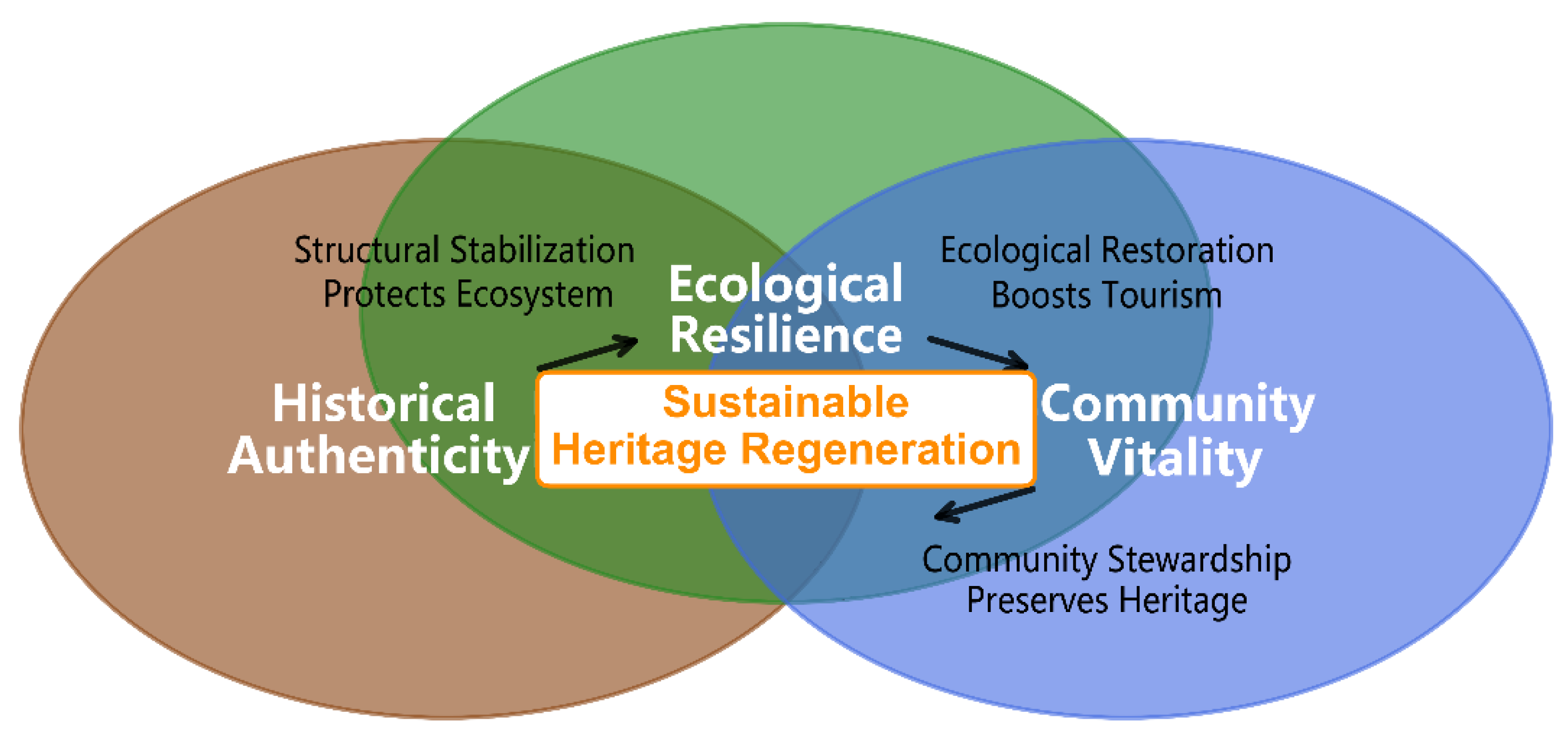
2.1. Theoretical Framework: The Tri-Dimensional Symbiosis Model
- Historical Dimension: The historical authenticity dimension draws upon the integrity–authenticity paradigm widely discussed in international conservation ethics, emphasizing not merely fabric preservation but the legibility of defensive spatial logic. It operationalizes material integrity through minimally invasive stabilization technologies and GIS-based spatial syntax analysis to maintain the site’s semiotic capacity to convey military narratives [34,35,36].
- Ecological Dimension: The ecological resilience dimension builds on socio-ecological systems (SES) resilience theory, treating the site as a landscape matrix supporting biodiversity and ecosystem services. This dimension moves beyond static conservation to active restoration, employing bioengineering and habitat corridor creation to enhance the site’s adaptive capacity to climate variability and anthropogenic disturbance [23].
- Community Dimension: Community Vitality is rooted in sustainable livelihoods theory and participatory development, focusing on the equitable distribution of conservation benefits and the decentralization of heritage governance responsibilities. It recognizes heritage sites as nested within local socio-economic systems, where community stewardship is more likely to emerge when tangible benefit-sharing mechanisms complement regulatory frameworks [27].
2.2. Quantitative Assessment: The Symbiotic Interface Index (SII)
2.3. Integrated Spatial Archaeology Methodology
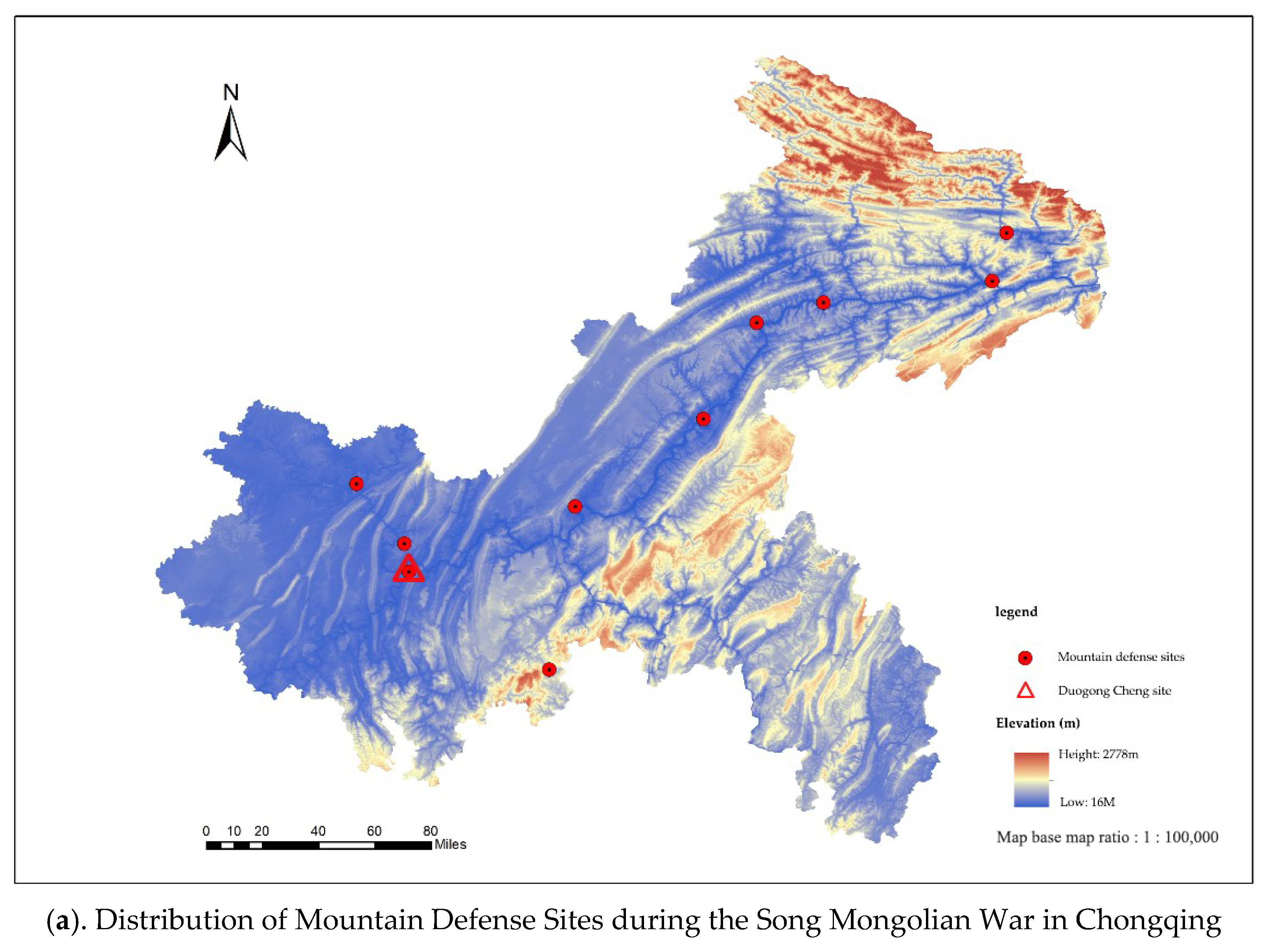
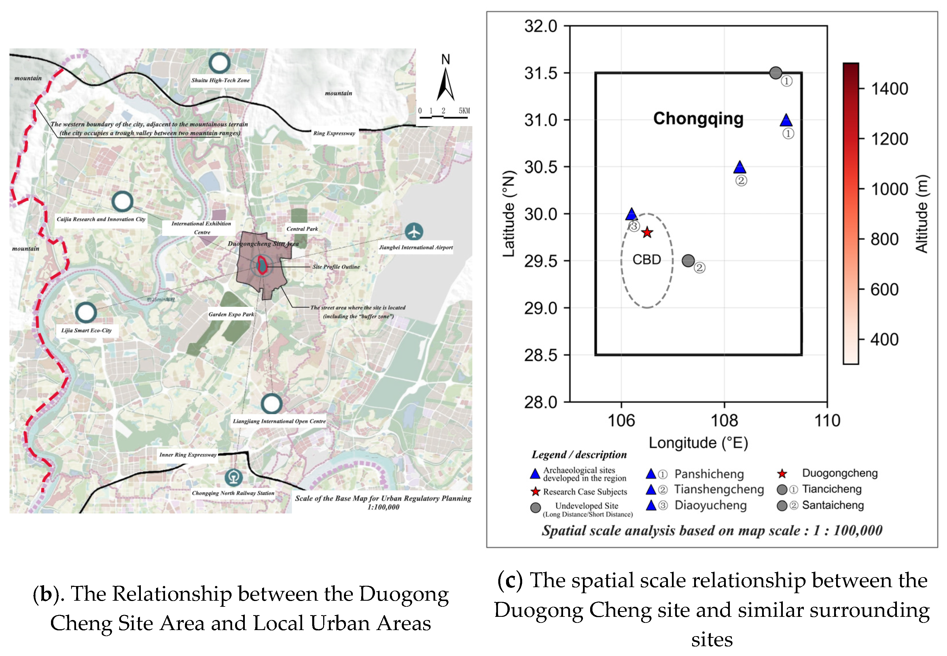
2.4. Study Area
- Historical Representativeness: Sites must contain intact defensive architecture from the Southern Song Dynasty with documented historical significance in official gazetteers (<<History of Song>>: “Sichuan Comprehensive Gazetteer”), ensuring typological consistency in military function and construction techniques.
- Conservation Status Gradient: Inclusion of sites across the full management spectrum: undeveloped (Tiancicheng, Santaicheng, Longyancheng), partially developed/under active management (Duogongcheng), and fully touristified (Diaoyucheng, Baidicheng) to test framework robustness under varying intervention intensities and governance capacities.
- Spatial Scale Heterogeneity: Site areas span approximately three orders of magnitude (2400–2,500,000 m2), allowing assessment of SII applicability across both micro-fortifications (e.g., Longyancheng) and larger defensive systems (e.g., Diaoyucheng), thereby supporting evaluation of dimensional scalability.
- Ecological Diversity: The sample covers altitudinal gradients ranging from 272 to 1784 m above sea level and diverse bioclimatic zones within Chongqing’s subtropical monsoon climate, encompassing riverine valleys (Panshicheng, 285 m), mid-elevation hills (Duogongcheng, 427.5 m), and high-mountain plateaus (Longyancheng, 1784 m).
- Threat Intensity Variation: Inclusion of sites facing distinct pressure types: urban encroachment (proximity <10 km to urban centers: Duogongcheng, Old Drum Tower), isolated abandonment (remote locations >50 km from urban infrastructure: Tiancicheng), and intensive tourism pressure (annual visitors >1 million: Diaoyucheng).
- Data Accessibility: Site selection also considered the availability of historical archival data, permissions for Terrestrial Laser Scanning (TLS) and UAV photogrammetry, and demonstrated community willingness to participate in socioeconomic surveys (preliminary consultations conducted 2020–2021).
2.5. Data Collection and Sources
- Spatial and Structural Data: High-precision deformation monitoring using a FARO Focus S350 TLS system (FARO Technologies, Lake Mary, FL, USA; scanning distance: 0.6–350 m, point cloud density: 1,000,000 points/s, 50 sampling points at Duogongcheng); 3D site reconstruction via DJI Phantom 4 RTK UAV photogrammetry (DJI, Shenzhen, China; spatial resolution: 2 cm/pixel); spatial conflict and terrain analysis using ArcGIS Pro 3.0.
- Social and Economic Data: Structured household surveys (n = 287, sample size determined via G*Power 3.1 with effect size = 0.3, α = 0.05, power = 0.9) employing a 5-point Likert scale; semi-structured in-depth interviews with 32 key stakeholders (heritage managers, local officials, community leaders, residents).
- Value Assessment Data: Application of the multi-criteria matrix (23 indicators) for SII scoring across sites, informed by expert panels (n = 15, including 8 academic experts and 7 industry practitioners), field surveys, and ecological sampling.
2.6. Analytical Framework and Process
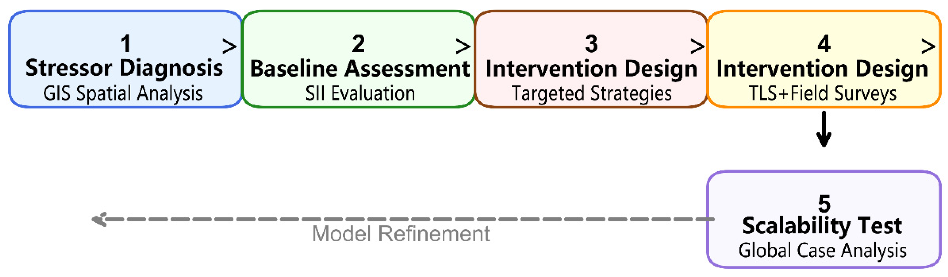
- Stressor Diagnosis: GIS-based spatial analysis to map and quantify threats from urbanization, tourism infrastructure, and environmental processes.
- Symbiotic Baseline Assessment: Application of the SII to evaluate the current state of symbiotic balance across all twelve study sites.
- Targeted Intervention Design: Development of context-specific strategies for each of the three dimensions (Historical, Ecological, Community) at Duogongcheng.
- Implementation and Monitoring: Piloting of interventions with continuous monitoring of structural, ecological, and socio-economic indicators over a 24-month period (2021–2023).
- Model Refinement and Scalability: Validation of the framework’s transferability through comparative analysis with documented cases of mountain military heritage in other global contexts (e.g., Alpine, Andean).
2.7. Ethical and Conflict of Interest Statements
3. Results
3.1. Baseline Symbiotic Status of Key Sites
3.2. Intervention Outcomes at Duogongcheng
3.2.1. Historical Dimension: Efficacy of Micro-Interventions
3.2.2. Ecological Dimension: Enhanced Landscape Resilience
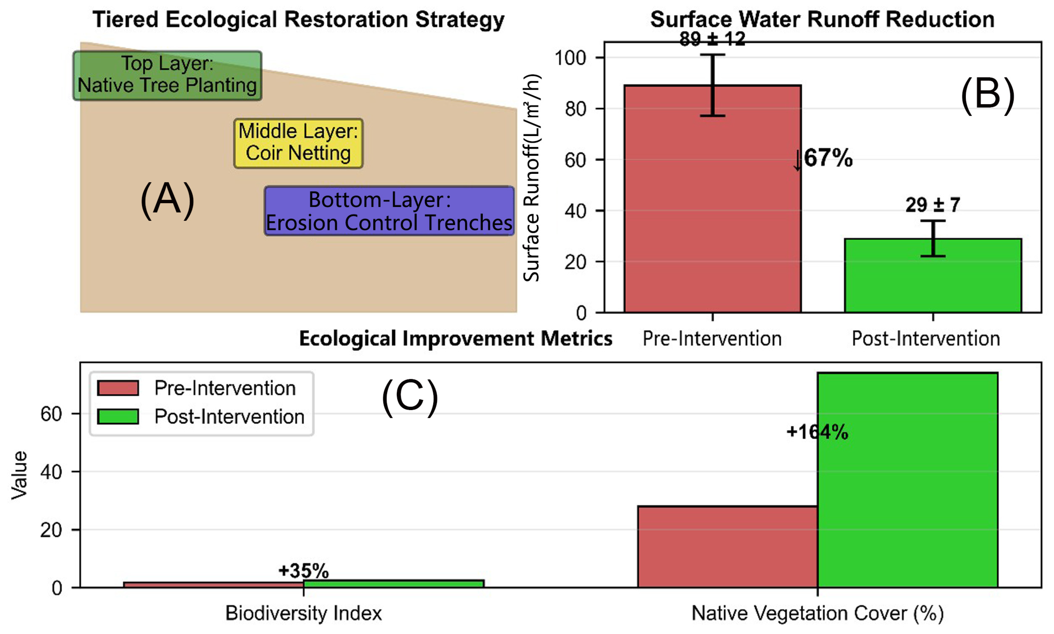
- 67% reduction in surface water runoff (from 89 ± 12 to 29 ± 7 L/m2/h; n = 12 plots; p < 0.01) over two rainy seasons.
- Reintroduction of 46 native plant species (e.g., Quercus variabilis, Rhus chinensis), increasing the site’s biodiversity index by 35% (from 1.82 to 2.46; n = 50 quadrats; p < 0.05).
- Application of biodegradable coir netting on slopes >25° reduced soil erosion by 58% (from 6.2 ± 1.1 to 2.6 ± 0.7 t/km2/year; p < 0.01).
3.2.3. Community Dimension: Impact of Cooperative Governance
- Participating households saw an average annual income increase of 28.5% (from CNY 65,245 ± 8320 to CNY 83,845 ± 9150; n = 37; p < 0.01).
- Vandalism and unauthorized encroachment incidents decreased by 34% (from 15 to 10 cases/year), supported by a community-managed monitoring fund.
- 76% of surveyed residents reported a strengthened sense of cultural pride and identity linked to the site (n = 287; p < 0.001).
3.3. Spatial Conflict Mitigation Through Zoning
3.4. Preliminary Validation of Global Adaptability
4. Discussion
4.1. Theoretical and Methodological Contributions
4.2. Policy and Management Implications
4.2.1. Regulatory and Zoning Instruments
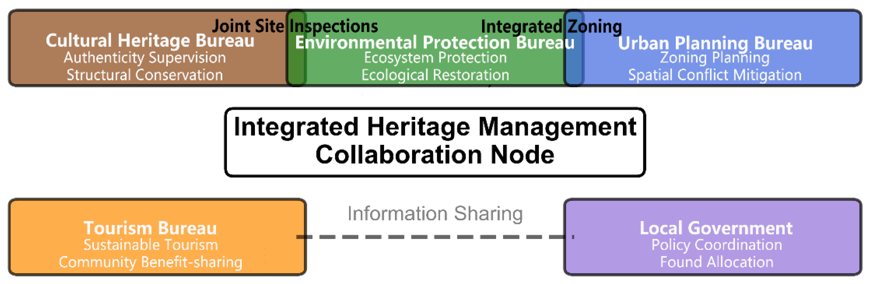
4.2.2. Institutional Collaboration Framework
4.2.3. Context-Adaptive Implementation Guidelines
4.3. Limitations and Scalability
4.4. Future Research Directions
5. Conclusions
Author Contributions
Funding
Institutional Review Board Statement
Data Availability Statement
Acknowledgments
Conflicts of Interest
References
- Gheyle, W.; Stichelbaut, B.; Saey, T.; Note, N.; Van den Berghe, H.; Van Eetvelde, V.; Van Meirvenne, M.; Bourgeois, J. Scratching the surface of war: Airborne laser scans of the Great War conflict landscape in Flanders (Belgium). Appl. Geogr. 2018, 90, 55–68. [Google Scholar] [CrossRef]
- Chen, Y.D. Outstanding model of mountain military defense system construction at the Diaoyucheng site in Hechuan. Chongqing World 2022, 6, 42–55. (In Chinese) [Google Scholar]
- Kareiva, P.; Marvier, M. An operational framework for resilience in cultural heritage systems. Ecol. Soc. 2015, 20, 15. [Google Scholar]
- ICOMOS. Nara Document on Authenticity; ICOMOS: Charenton-le-Pont, France, 1994. [Google Scholar]
- Jäggi, M.; Phillips, M.; Marty, C. Cold war fortifications in the Swiss Alps: Conservation challenges in permafrost regions. Cold Reg. Sci. Technol. 2018, 155, 123–135. [Google Scholar]
- Chen, H.; Zhao, D.; Zhang, L.; Zhang, S.; You, R.; Zhang, W.; Yang, Y. Research on urban design control methods for intermontane basin “Bazi” city in Southwest China during territorial space planning. Buildings 2025, 15, 2389. [Google Scholar] [CrossRef]
- Bandarin, F.; Van Oers, R. The Historic Urban Landscape: Managing Heritage in an Urban Century; Wiley-Blackwell: Hoboken, NJ, USA, 2012. [Google Scholar]
- Berkes, F.; Colding, J.; Folke, C. (Eds.) Navigating Social-Ecological Systems: Building Resilience for Complexity and Change; Cambridge University Press: Cambridge, UK, 2003. [Google Scholar]
- Šukienė, A.L.; Jureņienė, V. Heritage management models for sustainable community tourism development. Tour. Hosp. 2024, 6, 111–134. [Google Scholar]
- UNESCO World Heritage Centre. Monitoring Indicator Framework for World Heritage; UNESCO: Paris, France, 2021. [Google Scholar]
- Farr, T.G.; Rosen, P.A.; Caro, E.; Crippen, R.; Duren, R.; Hensley, S.; Kobrick, M.; Paller, M.; Rodriguez, E.; Roth, L.; et al. The shuttle radar topography mission. Rev. Geophys. 2007, 45, RG2004. [Google Scholar] [CrossRef]
- Zhang, J.; Ji, Q.; Skene, K.R.; Wu, X.; Zhou, C.; Wang, S.; Fu, B. Bridging resilience and sustainability: A reconciled framework for navigating social-ecological systems. Reg. Environ. Change 2025, 25, 106. [Google Scholar] [CrossRef]
- Snyder, H. Literature review as a research methodology: An overview and guidelines. J. Bus. Res. 2019, 104, 333–339. [Google Scholar] [CrossRef]
- Patton, M.Q. Qualitative Research & Evaluation Methods, 4th ed.; SAGE Publications: Thousand Oaks, CA, USA, 2015; pp. 264–267. [Google Scholar]
- Creswell, J.W.; Creswell, J.D. Research Design: Qualitative, Quantitative, and Mixed Methods Approaches, 5th ed.; SAGE Publications: Thousand Oaks, CA, USA, 2017. [Google Scholar]
- Brumana, R.; Della Torre, S.; Previtali, M.; Barazzetti, L.; Cantini, L.; Oreni, D.; Banfi, F. Generative HBIM modelling to embody complexity (LOD, LOG, LOA, LOI): Surveying, preservation, site intervention—The Basilica di Collemaggio (L’Aquila). Appl. Geomat. 2018, 10, 545–567. [Google Scholar] [CrossRef]
- Xu, Z.H.; Wu, L.; Shen, Y. Tridimensional reconstruction applied to cultural heritage with the use of camera-equipped UAV and terrestrial laser scanner. Remote Sens. 2014, 6, 10413–10434. [Google Scholar] [CrossRef]
- Ferretti, V.; Pomarico, S. Ecological land suitability analysis through spatial indicators: An application of the Analytic Network Process technique. Ecol. Indic. 2013, 34, 98–110. [Google Scholar] [CrossRef]
- Meynard, P.M. Monitoring ecosystem functions in mountain catchments of Chilean Patagonia: A cluster-based dataset. Data Brief 2026, 65, 112481. [Google Scholar] [CrossRef] [PubMed]
- Yin, R.K. Case Study Research: Design and Methods, 5th ed.; SAGE Publications: Thousand Oaks, CA, USA, 2014; pp. 53–58. [Google Scholar]
- Shakir, M. The selection of case studies: Strategies and their advantages/disadvantages. Learn. Organ. 2002, 9, 106–116. [Google Scholar]
- Liu, L.; Liu, X.; Zhang, Y. Tourism-driven land use transitions and rural livelihood resilience: A spatial production approach to sustainable development in China’s heritage areas. Sustainability 2025, 17, 10839. [Google Scholar] [CrossRef]
- Chambers, R.; Conway, G. Sustainable Rural Livelihoods: Practical Concepts for the 21st Century (IDS Discussion Paper No. 296); Institute of Development Studies: Brighton, UK, 1992. [Google Scholar]
- Manzano Fernández, S.; Vegas López-Manzanares, F.; Mileto, C.; Cristini, V. Principles and sustainable perspectives in the preservation of earthen architecture from the past societies of the Iberian Peninsula. Sustainability 2024, 16, 5172. [Google Scholar] [CrossRef]
- Zhu, X.G.; Gan, W.Q.; Wang, W. Protection and renewal of historical and cultural districts in the context of urban renewal: A comparative analysis based on research progress at home and abroad. China Anc. City 2024, 38, 39–48. [Google Scholar]
- Molinié, A. L’instrumentalisation des sites archéologiques incas: Questions d’éthique. Can. J. Bioeth./Rev. Can. Bioéthique 2019, 2, 105–116. [Google Scholar] [CrossRef]
- Xie, J.; Chen, J.; Liu, Y. Participatory intention and behavior in green cultural heritage conservation: An application of the extended theory of planned behavior. Herit. Sci. 2024, 12, 299. [Google Scholar] [CrossRef]
- Tapete, D.; Cigna, F. Rapid mapping and deformation analysis over cultural heritage and rural sites based on persistent scatterer interferometry. Int. J. Geophys. 2012, 2012, 618609. [Google Scholar] [CrossRef]
- Doering, E.L.; Cooper, B.R. Media review: Qualitative comparative analysis in mixed methods research and evaluation. J. Mix. Methods Res. 2023, 17, 112–117. [Google Scholar] [CrossRef]
- González Albornoz, P.; Rubio Manzano, C.; López, M.I. Explaining urban transformation in heritage areas: A comparative analysis of predictive and interpretive machine learning models for land-use change. Mathematics 2025, 13, 3971. [Google Scholar] [CrossRef]
- Li, Y.; Guo, J.; Zhao, L.; Chen, Y.; Wang, C.; Li, J. Spatial evolution path of Gulangyu Island historical international community: From the perspective of actor-network theory. Herit. Sci. 2021, 9, 112. [Google Scholar] [CrossRef]
- Hasson, F.; Keeney, S.; McKenna, H. Research guidelines for the Delphi survey technique. J. Adv. Nurs. 2000, 32, 1008–1015. [Google Scholar] [CrossRef]
- Chen, F.; Wang, X.; Liu, J.; Liu, S. Space technologies for sustainable heritage: 10th anniversary of HIST. Herit. Sci. 2021, 9, 156. [Google Scholar] [CrossRef]
- Stovel, H. Origins and influence of the Nara document on authenticity. APT Bull. J. Preserv. Technol. 2008, 39, 9–17. [Google Scholar]
- Bratun, Z. Military-geographic evaluation of the Julian Alps area. Dela 1999, 41, 249–262. [Google Scholar] [CrossRef]
- Du, F.L.; Li, M.; Chen, H. Research on the protection and utilization path of urban sites from the perspective of functional synergy. China Anc. City 2024, 39, 55–62. (In Chinese) [Google Scholar]
- Kawanishi, T.; Nishi, K. Salt spray damage and conservation of coastal concrete fortifications in Japan. Coast. Eng. J. 2019, 61, 334–345. [Google Scholar]
- Kerrigan, M.R. A framework for understanding community colleges’ organizational capacity for data use. J. Mix. Methods Res. 2014, 8, 334–348. [Google Scholar] [CrossRef]
- Zhang, Z.; Dang, A.R.; Hou, M.L. Construction of information technology method framework for the protection and utilization of the Great Wall cultural heritage. J. Remote Sens. 2021, 25, 2339–2350. (In Chinese) [Google Scholar]
- Liu, R.Q.; Gao, W.F.; Yang, F. Authenticity, integrity, and cultural–ecological adaptability in heritage conservation. Buildings 2024, 15, 1304. [Google Scholar]
- López Gabriel, E.J.; Coloca Federico, I.; Seguí Silvina, T. Andean sacred mountains during the expansion of the Inca Empire: An archaeological view from north-western Argentina. Antiquity 2025, 99, 1114–1128. [Google Scholar] [CrossRef]






| Methodological Paradigm | Technical Advantages | Key Limitations | This Research Solution |
|---|---|---|---|
| Technical Methods (TLS/Photogrammetry) | Sub-millimetre structural precision | Neglecting socio-economic feedback | Coupled Community Impact Assessment |
| Ecological Model (GIS) | Landscape connectivity analysis | Regarding heritage as an obstacle | Cultural-Ecological Coupling Integration |
| Community involvement | Capturing social dynamics | Lack of technical precision | Implementation of TLS quantitative monitoring |
| Dimension | Indicator Code | Indicator Name | Measurement Protocol | Score Thresholds (0–10) |
|---|---|---|---|---|
| Historical Authenticity (H) | H1 | Structural Deformation | TLS monitoring (mm displacement) | 0–3: >15 mm; 4–6: 8–15 mm; 7–10: <8 mm |
| H2 | Masonry Integrity | Visual survey (% original fabric) | 0–3: <30%; 4–6: 30–70%; 7–10: >70% | |
| H3 | Mortar Condition | Petrographic analysis (weathering grade) | 0–3: Severe; 4–6: Moderate; 7–10: Sound | |
| H4 | Defensive Sightline Integrity | GIS viewshed analysis (% unobstructed) | 0–3: <40%; 4–6: 40–75%; 7–10: >75% | |
| H5 | Topographic Integration | DEM slope/elevation match (%) | 0–3: <50%; 4–6: 50–80%; 7–10: >80% | |
| H6 | Access Route Preservation | Field survey (% original path) | 0–3: <25%; 4–6: 25–60%; 7–10: >60% | |
| H7 | Gate/Watchtower Condition | Structural assessment (stability score) | 0–3: Collapsed; 4–6: Compromised; 7–10: Stable | |
| H8 | Historical Narrative Coherence | Document analysis (continuity index) | 0–3: Fragmented; 4–6: Partial; 7–10: Continuous | |
| H9 | Archaeological Deposit Integrity | Geophysical survey (disturbance %) | 0–3: >60%; 4–6: 20–60%; 7–10: <20% | |
| H10 | Material Authenticity | Laboratory analysis (original material %) | 0–3: <40%; 4–6: 40–75%; 7–10: >75% | |
| Ecological Compatibility (E) | E1 | Native Species Richness | Field quadrats (Shannon index) | 0–3: <1.0; 4–6: 1.0–2.0; 7–10: >2.0 |
| E2 | Native Vegetation Cover | UAV imagery (% canopy) | 0–3: <20%; 4–6: 20–50%; 7–10: >50% | |
| E3 | Habitat Connectivity | GIS least-cost path (fragmentation index) | 0–3: High; 4–6: Moderate; 7–10: Low | |
| E4 | Soil Stability | Erosion pins (t/km2/year) | 0–3: >10; 4–6: 3–10; 7–10: <3 | |
| E5 | Hydrological Regulation | Runoff plots (L/m2/h) | 0–3: >80; 4–6: 30–80; 7–10: <30 | |
| E6 | Microclimate Stability | Sensor network (°C/RH variation) | 0–3: High variation; 4–6: Moderate; 7–10: Stable | |
| E7 | Invasive Species Control | Field survey (% cover) | 0–3: >30%; 4–6: 10–30%; 7–10: <10% | |
| E8 | Pollinator Presence | Transect counts (species/h) | 0–3: <2; 4–6: 2–5; 7–10: >5 | |
| E9 | Erosion Control Efficacy | Sediment traps (g/L) | 0–3: >5; 4–6: 1–5; 7–10: <1 | |
| E10 | Biomass Accumulation | Quadrat harvest (kg/m2) | 0–3: <0.5; 4–6: 0.5–1.5; 7–10: >1.5 | |
| Social Participation (S) | S1 | Community Engagement Depth | Survey (participation frequency/year) | 0–3: None; 4–6: Occasional; 7–10: Regular |
| S2 | Benefit Distribution Fairness | Gini coefficient (income equity) | 0–3: >0.5; 4–6: 0.3–0.5; 7–10: <0.3 | |
| S3 | Local Stewardship Level | Resident survey (self-reported responsibility) | 0–3: None; 4–6: Partial; 7–10: Full | |
| S4 | Tourism Revenue Share | Financial records (% to community) | 0–3: <10%; 4–6: 10–30%; 7–10: >30% | |
| S5 | Cultural Pride Index | Likert scale (1–5 converted to 0–10) | 0–3: Low; 4–6: Moderate; 7–10: High | |
| S6 | Heritage Knowledge Transmission | Interview (intergenerational transfer) | 0–3: Absent; 4–6: Weakened; 7–10: Active | |
| S7 | Governance Participation | Meeting attendance (%) | 0–3: <20%; 4–6: 20–50%; 7–10: >50% | |
| S8 | Conflict Resolution Capacity | Documented incidents (cases/year) | 0–3: >10; 4–6: 3–10; 7–10: <3 |
| Assessment Tool | Primary Focus | Advantages of the SII | Limitations of Comparators |
|---|---|---|---|
| UNESCO Heritage Sustainability Assessment | General heritage management | Integrates military-specific spatial logic; explicitly quantifies community ecology history synergies. | Lacks metrics for defensive characteristics; often weak on social ecological feedback mechanisms. |
| Military Heritage Value Index [26] | Military heritage value | Incorporates ecological compatibility; designed for dynamic, feedback-oriented management. | Primarily a static value assessment; lacks a structured community participation dimension. |
| Cultural Landscape Symbiosis Index [26] | Cultural landscapes | Offers standardized scoring applicable globally; links clearly to SDGs. | Not adapted to rugged mountain topography; weak on technical structural conservation metrics. |
| Site Name | Period (AD) | Area (m2) | Altitude (m) | Designation/Title | Current Status | Primary Selection Criterion |
|---|---|---|---|---|---|---|
| Hechuan Diaoyu cheng | 1242 | 2,500,000 | ~300 | “Oriental Mecca City” | National 4A Scenic Spot | Tourism pressure reference (high-intensity) |
| Yunyang Panshicheng | 1242 | 35,000 | 285 * | “First Yangtze River Defense” | Archaeological Park | Riverine defense typology |
| Wanzhou Tianshengcheng | 1243 | 266,666 | 467 | “City Close to the Sky” | Archaeological Park | Mid-altitude ecosystem |
| Nanchuan Longyancheng | 1255 | 2400 | 1784 | “Invincible Southern Barrier” | Cultural Unit (Under Repair) | High-altitude/remote reference |
| Wushan Tiancicheng | 1262 | 800,000 | 352 * | -- | Cultural Unit (Undeveloped) | Abandonment/neglect scenario |
| Fuling Santaicheng | 1266 | 90,000 | 310 | “Guiling City” | Cultural Unit (Undeveloped) | Low-altitude undeveloped |
| Yubei Duogongcheng | 1270 | 10,000 | 427.5 | “Command Outpost” | Cultural Unit (In Development) | Intervention pilot (intermediate) |
| Fengjie Baidicheng | 1533 | 3090 | 298 * | “Poetry City” | Cultural Unit (Tourist Area) | Post-Song adaptation reference |
| Zhongxian Huanghuacheng | 1254 | 1,400,000 | 272 | -- | Cultural Unit (Undeveloped) | Large-scale undeveloped |
| Yuzhong Old Drum Tower | 1243 | 45,000 | 320 * | “Mountain Command Center” | Archaeological Park (Under Constr.) | Urban embedded context |
| Site | Historical (H) | Ecological (E) | Social (S) | SII |
|---|---|---|---|---|
| Diaoyucheng | 8.2 | 6.1 | 7.5 | 7.37 |
| Duogongcheng | 9.1 | 8.3 | 6.8 | 8.19 |
| Baidicheng | 7.4 | 5.7 | 8.2 | 7.08 |
| Tianshengcheng | 7.8 | 6.5 | 5.9 | 6.91 |
| Santaicheng | 8.0 | 5.1 | 4.2 | 6.19 |
| Huanghuacheng | 7.6 | 5.3 | 4.5 | 6.27 |
| Indicator | Pre-Intervention (2021) | Post-Intervention (2023) | Change | Statistical Significance |
|---|---|---|---|---|
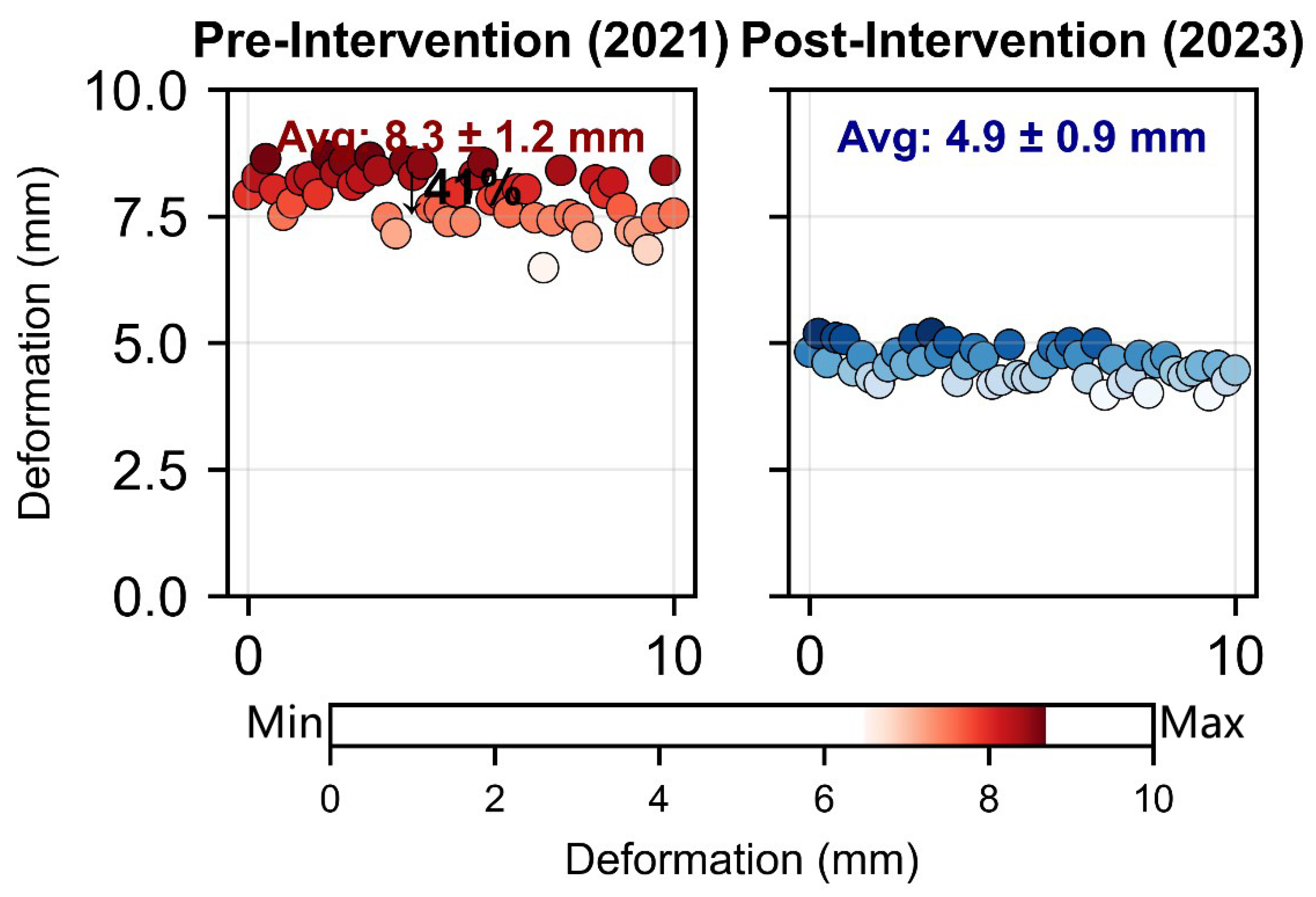
| Structural Deformation (mm) | 8.3 ± 1.2 | 4.9 ± 0.9 | −41% | p < 0.001 |
| Surface Runoff (L/m2/h) | 89 ± 12 | 29 ± 7 | −67% | p < 0.01 |
| Avg. Household Income (CNY/year) | 65,245 ± 8320 | 83,845 ± 9150 | +28.5% | p < 0.01 |
| Biodiversity Index | 1.82 ± 0.31 | 2.46 ± 0.42 | +35% | p < 0.05 |
| Vandalism/Encroachment (cases/year) | 15 ± 3 | 10 ± 2 | −34% | p < 0.05 |
| Native Vegetation Cover (%) | 28 ± 5 | 74 ± 8 | +164% | p < 0.001 |
| Global Case | Climate/Topography Context | Baseline SII (Estimated) | Adapted Intervention Strategies | Implementation Adjustments | Predicted SII Improvement |
|---|---|---|---|---|---|
| Alpine WWII Fortifications (Switzerland) | Cold alpine, high altitude (1500–2500 m); permafrost risk | 6.2 (Structural: 7.1; Ecological: 5.8; Social: 5.7) | Rock-wool stabilization for weathering cycles; drought-resistant native conifers (Picea abies); community ski-tourism integration | Add insulation layers; snow fence installation; seasonal tourism closure protocols | +18% (to ~7.3) |
| Inca Mountain Forts (Peru) | Arid high-altitude, steep slopes; seismic zone | 5.8 (Structural: 6.5; Ecological: 4.9; Social: 6.0) | Earthen rampart reinforcement with natural clay mixes; xerophytic native species (Tillandsia); community co-management with Quechua groups | Seismic retrofitting; drip irrigation for establishment phase; traditional knowledge integration | +16% (to ~6.7) |
| Coastal Defense Forts (Japan) | Humid coastal, salt spray; typhoon exposure | 6.1 (Structural: 6.8; Ecological: 5.5; Social: 6.0) | Anti-corrosion grouting for metal; salt-tolerant native vegetation (Spartina); controlled visitor caps during monsoons | Cathodic protection systems; windbreak planting; typhoon-resistant signage | +15% (to ~7.0) |
| Ecological Context | Historical Intervention Adjustments | Ecological Intervention Adjustments |
|---|---|---|
| Arid Mountains | Use desert-adapted lime/gypsum mortars; minimize water use in restoration. | Prioritize xerophytic native species; employ drip irrigation during the establishment phase. |
| Coastal Mountains | Use anti-corrosion treatments and salt-resistant binding materials. | Plant halophytic (salt-tolerant) species; install windbreaks to mitigate salt spray. |
| Cold Alpine | Use weathering-resistant polymers/stitching; add insulation layers to masonry. | Use cold-hardy evergreen species for ground cover; install snow fences to manage drift. |
Disclaimer/Publisher’s Note: The statements, opinions and data contained in all publications are solely those of the individual author(s) and contributor(s) and not of MDPI and/or the editor(s). MDPI and/or the editor(s) disclaim responsibility for any injury to people or property resulting from any ideas, methods, instructions or products referred to in the content. |
© 2026 by the authors. Licensee MDPI, Basel, Switzerland. This article is an open access article distributed under the terms and conditions of the Creative Commons Attribution (CC BY) license.
Share and Cite
Du, F.; Chen, Y.; Liu, H.; Jiang, L.; Wu, Y. Living Protection and Integrated Use of Cultural Sites from the Perspective of Functional Synergy: The Case of the Duogongcheng Site in Chongqing. Heritage 2026, 9, 87. https://doi.org/10.3390/heritage9030087
Du F, Chen Y, Liu H, Jiang L, Wu Y. Living Protection and Integrated Use of Cultural Sites from the Perspective of Functional Synergy: The Case of the Duogongcheng Site in Chongqing. Heritage. 2026; 9(3):87. https://doi.org/10.3390/heritage9030087
Chicago/Turabian StyleDu, Fulin, Yang Chen, Hongtao Liu, Longxiang Jiang, and Yisha Wu. 2026. "Living Protection and Integrated Use of Cultural Sites from the Perspective of Functional Synergy: The Case of the Duogongcheng Site in Chongqing" Heritage 9, no. 3: 87. https://doi.org/10.3390/heritage9030087
APA StyleDu, F., Chen, Y., Liu, H., Jiang, L., & Wu, Y. (2026). Living Protection and Integrated Use of Cultural Sites from the Perspective of Functional Synergy: The Case of the Duogongcheng Site in Chongqing. Heritage, 9(3), 87. https://doi.org/10.3390/heritage9030087