Abstract
Digital technologies significantly influence architectural heritage perception, preservation, and presentation, particularly in reconstructing fragmented archaeological sites. This study explores innovative applications of algorithmic design, Heritage Building Information Modelling (HBIM), and interactive visualisation through the virtual reconstruction of the Roman Forum Transitorium in Musti, Tunisia—a complex historical site influenced by Numidian, Roman, and Byzantine cultures. The research integrates algorithmic modelling, digital surveying, and cloud-based collaboration, employing software tools such as Archicad, Rhino, Grasshopper, and Virtual Tour platforms. Central to this approach is a parametric, hypothesis-driven methodology, enabling the iterative exploration of multiple reconstruction scenarios informed by historical sources, architectural analyses, and scanned archaeological fragments. Immersive technologies enhance user engagement, allowing for the transparent exploration and interpretation of the site’s historical uncertainties. The results highlight the effectiveness of algorithmic methods in managing interpretative variability, offering flexible, academically rigorous, and publicly accessible virtual reconstructions. By emphasising the hypothetical nature of digital reconstructions and interactive visualisations, this research contributes meaningfully to digital archaeology, demonstrating how innovative algorithmic approaches can bridge academic scholarship and broader heritage preservation practices.
1. Introduction
As technology progresses at an unprecedented pace, professionals in various fields, including cultural heritage, must evolve to stay relevant. This is especially true for archaeologists, architects, and digital humanities experts, who grapple with keeping historical accuracy while embracing innovative tools. Our project tackles this challenge by employing algorithmic design and interactive visualisation to reconstruct the Roman Forum Transitorium in Musti, Tunisia. This method offers multiple reconstruction scenarios, highlighting their hypothetical nature and promoting a deeper, more nuanced understanding of ancient structures.
1.1. Adapting to Technological Evolution
In response to advancements in AI and digital tools, the presented project shows how specialised skills and innovative technologies can enhance cultural heritage preservation. The integration of Archicad 27, Rhino 7, and Grasshopper 1.0.0007 facilitated the development of an HBIM framework capable of transcending static representations. This approach ensures that reconstructions remain adaptable and relevant in a rapidly evolving technological landscape. Traditional static models often depict only one possible version of a historical site, but our algorithmic design process enables exploring multiple scenarios. We can dynamically adjust parameters through script-based simulations to reflect various historical interpretations. This method underscores the hypothetical nature of reconstructions and engages users by allowing them to interact with different potential outcomes [1]. Such flexibility is vital in a field where historical data is often uncertain, making it clear that users engage with hypotheses rather than definitive reconstructions.
The project employs interactive visualisation tools such as 3DVista and virtual reality (VR) in response to the changing landscape of cultural heritage education and presentation. These platforms allow for immersive experiences that can transform how findings are presented in museums and archaeological sites. By enabling users to engage with multiple reconstruction scenarios, we foster a deeper understanding of the complexities and uncertainties inherent in historical interpretation. These scenarios, allowing user-based reconstruction (explorative interaction), are crucial to understanding the hypothetical nature of virtual worlds related to the past [2]. Additionally, the project leverages cloud computing and globalised data storage to support collaborative research. Incorporating photogrammetry and laser scanning ensures that the digital surveys conducted are comprehensive and precise. These technologies enhance models’ accuracy and democratise access to high-quality digital heritage resources.
1.2. Research Background
The use of digital tools in archaeology spans over 35 years, during which perspectives on their role have evolved. Initially, virtual archaeology primarily referred to the application of new tools in the documentation process of archaeological sites [3]. Subsequently, digital tools expanded to include creating models enabling interaction, leveraging the potential of gamification following Maurizio Forte’s assertion that “we do not reconstruct the past anymore, we perform digital past” [4]. In this context, performativity was often referred to as the exploration of a virtual environment, which was typically prepared as a static representation of the recreated reality.
It should be noted that, throughout the evolution of digital methods, virtual models were frequently perceived as an alternative, parallel reality. As such, they provoked a dialectical approach to their utility, which was primarily evaluated in terms of presentation, often through the lens of visual appeal and often at odds with scientific credibility and methodological rigour. This led to situations where digital models were regarded with considerable reservation and limited trust, often seen as supplementary to a broader array of research and presentation methods. Hence, their use was restricted by many reservations and limited to specific circumstances.
In the approach proposed in our research, we seek to address this dialectic by introducing models of a dynamic nature, reflecting the characteristics of the studied past objects. The aim is to create models that can serve as research and presentation tools. The essence of the proposed interactivity lies in the ability to reconfigure an algorithmically defined model through continuous parameter manipulation (within a predefined range) or discrete modifications (within a set of defined choices/steps). This concept is grounded in understanding virtual hypothetical reconstruction as a simulation of a past situation, inherently constrained by information’s limited availability and certainty.
A fundamental aspect of any simulation is constructing a model highlighting the most significant features of the reality it aims to represent. The digital nature of the model, utilising an algorithmic approach, enables the explicit representation of a crucial characteristic of such reconstructions—namely, the ever-present uncertainty in the proposed interpretation, along with a clear indication of its degree. Consequently, applying dynamic digital models meets the requirements outlined in the London Charter [5] for using digital methods in cultural heritage: “A computer-based visualisation method should be normally used only when it is the most appropriate available method for that purpose”.
Virtual hypothetical reconstructions of historical heritage have been the subject of an increasingly rich body of recent scholarly literature. However, the modelling techniques employed in the reconstruction process have received comparatively less attention. In a recent systematic literature review, Ma et al. [6] organise existing research around five key phases of the virtual hypothetical reconstruction workflow as defined by Pietroni and Ferdani [7]: survey, documentation, data processing and interpretation, creation of the reconstructive hypothesis, and source mapping with transparency. Notably, within the reviewed studies, algorithmic methods are absent from discussions concerning the formulation of reconstructive hypotheses, pointing to a significant research gap. Most of the analysed publications focus on the survey and interpretation phases. At the same time, relatively less attention is directed toward generating and externalising the reconstruction hypothesis in the form of a digital model. However, the need to generate multiple reconstruction variants—especially in light of the visual and communicative expectations of diverse user groups—has been mentioned in the literature [7,8].
Considerable scholarly attention has also been devoted to presenting reconstructed heritage, including immersive and extended reality technologies (VR/XR). These technologies are widely recognised for their benefits, such as immersion, visual appeal, and increasing accessibility through the proliferation of mobile devices. Among the most frequently cited advantages of immersive technologies are enhanced user immersion and interaction [9] and their capacity to facilitate knowledge exchange and interdisciplinary collaboration within research workflows [10]. Nonetheless, challenges remain, particularly regarding high labour intensity and technical requirements associated with content development [11]. However, a closer analysis of the literature reveals that only a relatively small proportion of studies (24%) focus on explorative interaction—an approach emphasising user-driven discovery and interpretive engagement [12]. Such an approach is presented in the following article, particularly in the context of educational and public dissemination goals, where interactive and transparent reconstructions can serve as powerful tools for knowledge transfer and engagement.
2. Materials and Methods
The study applied an integrated methodological framework combining Heritage Building Information Modelling (HBIM), algorithmic modelling, and interactive visualisation technologies—including virtual tours, augmented reality (AR), and mixed reality (MR)—to explore advanced approaches to virtual reconstruction in the context of cultural heritage and address the need for more dynamic, engaging, and immersive methods of presenting virtual reconstructions [13]. The workflow was structured around three interrelated and overlapping phases—modelling, simulation, and visualisation—as illustrated in Figure 1, which outlines the conceptual structure and flow of the reconstruction process.
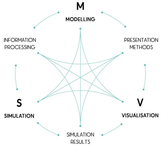
Figure 1.
Scheme representing topics’ collaboration (authors’ elaboration).
Musti’s Forum Transitorium reconstruction was based on collecting and processing architectural survey data, including laser scans and photogrammetric models (Figure 2a). Using Archicad 27 within a cloud-based collaborative environment, a parametric HBIM model of the preserved architectural remains was developed. Additionally, selected elements were modelled using boundary representation (BREP) techniques to reflect their geometric and structural specificity (Figure 2b) (modelling phase—see Figure 1).

Figure 2.
(a) Photogrammetric model of a Corinthian capital from Musti; (b) BREP model of the same capital (authors’ elaboration).
A procedural workflow was implemented to generate alternative reconstruction variants by manipulating key parameters within the HBIM model. These parameters were controlled using Grasshopper, with the modelling logic visualised through a graphical block-based representation that documented the variant generation process (Figure 3) (simulation phase—see Figure 1).
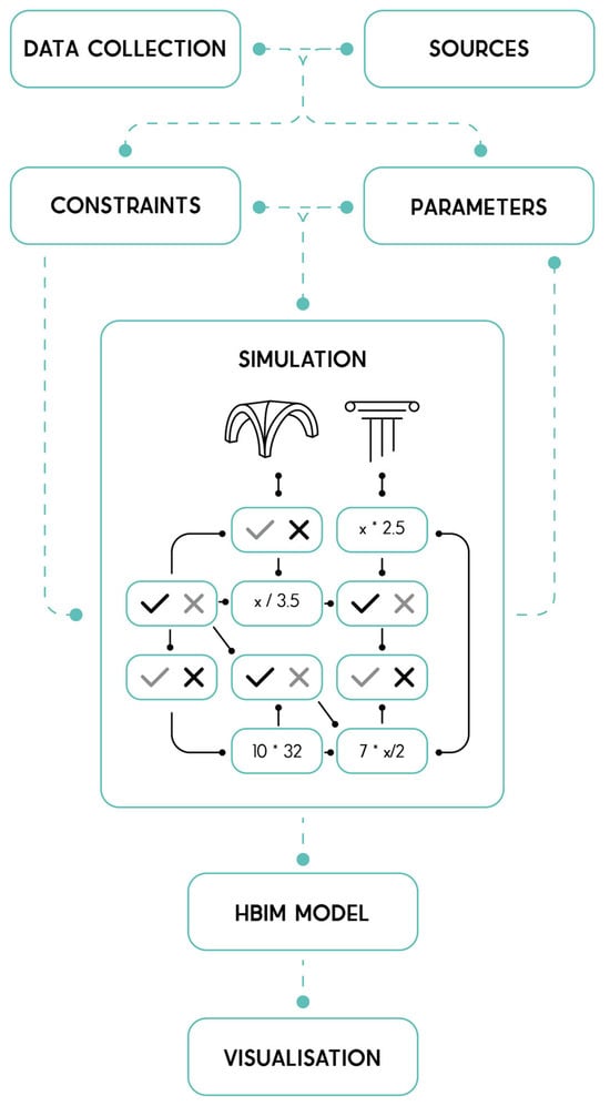
Figure 3.
Block representation of the reconstruction workflow process (authors’ elaboration).
An interactive visualisation pipeline was established to reflect the hypothetical and parametric nature of the reconstruction scenarios. This pipeline maintained dynamic integration between the modelling environment and various output formats, ensuring that changes to the source model were propagated consistently across representations (visualisation phase—see Figure 1).
A range of output techniques was evaluated to test the expressive and communicative capacity of the generated reconstruction variants. These included augmented reality (AR), virtual reality (VR), interactive table-based systems (e.g., InteracTable [14]), 3D printing, 360-degree panoramic renderings, and immersive virtual tours.
The study was incorporated into the course Information Processes in Architectural Heritage (IPAH), part of the master’s programme Architecture for Society of Knowledge (Faculty of Architecture, Warsaw University of Technology), where students were divided into three teams reflecting the three core process phases: modelling, simulation, and visualisation.
3. Case Study of Roman Forum Transitorium
Musti was a Roman city in the fertile Numidian and Roman African region near ancient Carthage (destroyed in 146 BC) and situated about 12 km southwest of Thugga (a UNESCO World Heritage site) and about 120 km from the capital, Tunis [15]. The size of Musti is about 0.32 km2, and most of it is still to be discovered [16].
The case presented in this paper focused on the virtual reconstruction of the Forum Transitorium, marked in Figure 4. The area is located in the centre of Musti, approximately midway between the two triumphal arches defining the urban limits. Positioned beside the connecting road, a paved square is bordered by two temples adjacent to the arch, which functioned as the entrance to a perpendicular street leading to the main Forum. According to Ferchiou [17], the central location of this area led to frequent redevelopment and transformation, making it difficult to analyse its components. Continuous occupation from the Caesarian through the imperial, Vandal, and Byzantine periods further complicates its study. The construction of the Byzantine fortress in the upper city destroyed many earlier monuments, which were reused as quarries. Ornamentally, the surviving material is limited, as numerous reliefs were re-cut or defaced. Ferchiou notes that reconstructing the appearance remains problematic due to later alterations that obscured its form and early excavations (1958–1960) that disrupted the provenance of architectural blocks.

Figure 4.
The vector plan of the archaeological site of Musti overlayed on an orthophotomap of the site, with a marked area of interest. The plan drawing by Magdalena Antos.
The archaeological work was conducted under the project “(Reading) African Palimpsest: The dynamics of urban and rural communities of Numidian and Roman Mustis (AFRIPAL),” a grant from the Polish National Science Centre (NCN), no. 2020/37/B/HS3/00348. The project aims to investigate the dynamics of change in one of the 200 cities of the Proconsular Africa province during the critical transition from Numidian settlements to Roman cities. It seeks to understand Musti’s development as part of Africa’s urban network and its role within the Roman Empire from the 5th century BC to the mid-3rd century AD. The project aspires to gain a holistic understanding of the city and its surroundings using various methods. AFRIPAL combines comprehensive surveying, environmental studies, satellite imagery, traditional excavation techniques, artefact analysis, and architectural virtual reconstructions of the sites to achieve these objectives [16].
3.1. Challenge
Given the rapid advancement of innovative digital technologies, two primary research questions are addressed in the present article within the context of virtual reconstruction in cultural heritage. First, which modelling techniques can effectively respond to the uncertainties involved in hypothetical reconstructions, while simultaneously ensuring scientific rigour, plausibility, high visual quality, and user engagement? Second, what strategies can be employed to streamline the typically time-intensive process of virtual reconstruction, particularly through maximising the interoperability of the created digital assets?
Traditional models of historical sites are static, presenting a single interpretation of the past. This approach fails to account for historical research’s uncertainties and evolving perspectives, which can mislead users into viewing reconstructions as definitive representations rather than informed hypotheses.
3.2. Solution
Instead of adopting a single virtual reconstruction approach, a simulation was employed as a reference framework, within which alternative hypotheses and uncertainties were tested, and incompatible variants were systematically excluded.
The described virtual reconstruction relied primarily on a system of geometric proportions and the integration of on-site elements that could be aligned with such principles. The limitations of this approach were addressed through an algorithmic design process, in which dynamic, script-based simulations enabled the adjustment of parameters to represent multiple plausible historical scenarios.
Such an approach highlighted the hypothetical nature of reconstructions, encouraging transparency about the uncertainties inherent in historical data [18,19,20]. It also engaged users by allowing them to interact with and explore how different variables and interpretations influence a site’s representation. Furthermore, this method is highly adaptable, accommodating new research insights and evolving alongside discoveries. In a field where certainty is rare and interpretations often change, this flexible and interactive approach shifts the focus from a fixed narrative to a spectrum of possibilities. It offers users a richer, more nuanced understanding of history and reinforces the iterative nature of historical inquiry.
3.2.1. Source Analysis
The process began with analysing Roman architectural orders, scanned architectural elements (example in Figure 2a and Figure 5a) from Musti, and a database of surveyed components compiled by Tunisian archaeologists. Through consultations with the Tunisian researcher Mounir Torchani, an initial correspondence was established based on dimensions, enabling a proportion system definition. Architectural elements not originally present in the research area were excluded, resulting in two pairs of equally probable layouts (Figure 5a).
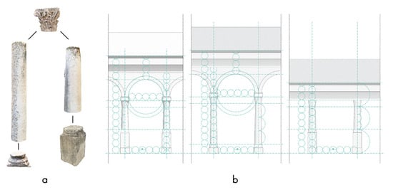
Figure 5.
(a) Virtual assembly of scanned on-site elements. Two pairs of equally probable layouts of bases and columns. (b) Presentation of different possible variants of proportions depending on the chosen elements (authors’ elaboration).
Subsequently, all potential variables and interrelations among the elements were identified, and a parametric block definition was formulated using parameters, modules, and ratios. This framework facilitated the regulation of possible arcade widths, base types, pedestals, column heights, vaults, and related components (Figure 5b). Regional deviations in proportions were also taken into account, as North African practices often departed from classical divisions to adapt to existing structures [17]. In the vicinity of Musti, for example, inscriptions were prioritised over formal order, resulting in friezes and architraves often being realised as single beams, bypassing strict Roman conventions [17].
This phase was completed without programming, focusing on comprehensively examining sources and available evidence. On this basis, the primary objectives and structure of the Grasshopper script were defined.
3.2.2. Parametric Model
A photogrammetric model, aligned with geodetic measurements (Figure 6b), was used to generate a 3D reconstruction of the existing state of the site and then to create a variant of virtual reconstruction (Figure 6a). Within the Archicad 27, Building Information Modelling (BIM) environment, distinct properties were assigned to each object. These attributes, derived from on-site surveys, provided information regarding chronology, potential affiliation, originality, and spatial authenticity. Consolidating these data within a single model enabled a comprehensive representation of the study area.
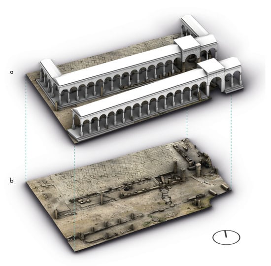
Figure 6.
(a) Virtual reconstruction superimposed on the photogrammetric model (b) Photogrammetric model of an existing site of Musti’s Forum Transitorium (authors’ elaboration).
All existing elements found on site were modelled parametrically, following the method presented by J. Franczuk [21], which involves using the programme’s native tools as much as possible and controlling everything numerically. The model of the site and its elements created in this way could be referenced to Grasshopper via Archicad-Grasshopper Connection, and their properties and parameters could be used in an algorithmic process.
3.2.3. Algorithmic Process
The script created in Grasshopper was based on a previous block diagram (Figure 3) and agreements with historians. This approach was chosen to limit the number of possible solutions and calculations. The numerical ranges of individual dimensions were also limited by implementing a Roman foot module and multiplying or dividing it accordingly. Without these limitations resulting from analysing sources, there could have been infinite solutions.
The geometric basis of the entire definition was curves as axes defining the porticos. They were divided into points, which were the centres of successive columns (Figure 7). The script was based on extracting previously prepared information and applying it as parameters for modelling subsequent elements, starting from the previously defined parametric objects derived from the scanned components. Their dimensions were taken in the script to define the higher levels of the buildings. There were two possible arrangements for bases, columns, and capitals, but everything above remained unknown. A proposed solution allowed for examining various roofing types available as variables. These included cross vaults, barrel vaults, and wooden beams, flat and gable roofs, frieze and architrave height (Figure 8), which were all based on an analysis of buildings in the neighbouring city of Thugga [22] and the expertise of Tunisian historians. All the elements used were interrelated, so changing a single thing or dimension affected the appearance of all the others.

Figure 7.
One of three possible solutions for dividing the total length of the Forum, keeping modules derived from measured on-site elements (authors’ elaboration).

Figure 8.
Two examples of solutions resulting from changing the parameters in the Grasshopper definition. (a) Virtual reconstruction superimposed on the photogrammetric model (b) Photogrammetric model of an existing site of Musti’s Forum Transitorium (authors’ elaboration).
3.2.4. Validation
The model of the existing site, linked to a Grasshopper script, was used to manipulate parameters and assess their effects (Figure 8). Different variants were subsequently evaluated in consultation with Tunisian historians and archaeologists, allowing inconsistent solutions to be excluded and the narrowing of possible outcomes. The subsequent stage focused on defining the module employed in the porticos. By dividing the total length of the Forum by modules derived from measured on-site elements, three equally probable intercolumniation values were obtained—6.5, 7, and 7.5 Roman feet (Figure 7). These module dimensions provided the basis for modelling the remaining porticos, as the proportional system governed their configuration.
3.3. Visualisation
The chosen visualisation method was a virtual tour with 360 renderings from the exact location as spherical panoramas taken on-site. This approach was adopted due to its efficiency and minimal technical requirements, as it did not necessitate programming skills associated with game engines. Additional considerations included the potential for integration with the developing Archicad model and the simplicity of sharing the results, since using 3Dvista software, the results could be web-viewed on any device without installing any additional application. The objective was to provide an interactive presentation that allowed the exploration of multiple perspectives and access to detailed information.
During excavations in Musti, around 80 spherical panoramas were taken using a full-frame Sony ILCE-7RM2 camera with a fisheye 11 mm lens. Each panorama was created as a High Dynamic Range (HDR) image by stitching 42 photographs—three shots with different exposure every 30° in horizontal rotation, top and bottom. Figure 9a shows one of the panoramas taken.
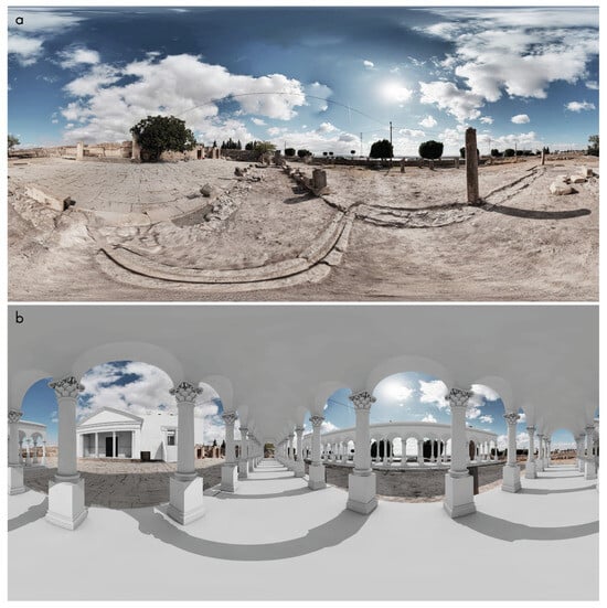
Figure 9.
(a) Spherical panorama taken on site; (b) 360 rendering superimposed on a spherical panorama (authors’ elaboration).
To optimise the visualisation process and facilitate the testing of reconstruction variants, the workflow was maintained entirely within Archicad, where 360° renderings of the virtual reconstruction were created (Figure 9b). However, precise camera positions—unrecorded during the fieldwork—were required for accurate comparison and superimposition with the existing panoramas.
A Grasshopper script was developed to calculate camera positions based on reference points defined in the 3D HBIM model and the 360° panoramas. These points were projected onto a sphere to obtain angular values between vectors directed towards the sphere’s centre. The optimisation process, carried out with the Galapagos plugin for Grasshopper, minimised differences between corresponding points in the panoramas and the 3D model. The genomes used in this process were the camera position’s X, Y, and Z coordinates (Figure 10b). The achieved accuracy was below 10 cm and 2°. The calculated coordinates and view rotation angles were subsequently integrated into the Archicad model as camera objects and employed as rendering viewpoints (Figure 10b). This procedure established a framework for presenting model data with false-colour overrides, enabling efficient updates in line with changes to reconstruction variants.

Figure 10.
Approximate camera location (blue sphere) search process by mapping points (orange) on a sphere and optimising to find the closest match among angles. (a) Photogrammetric 3D model with marked reference points; (b) The same reference points are marked on the spherical panorama (authors’ elaboration).
3.4. Analysis
From a coordination perspective, the project presented significant challenges. Despite the sequential steps outlined above, the workflow unfolded simultaneously, relying on collaboration and seamless data exchange. One advantage of this approach was the ability to examine a wide range of potential outcomes, including speculative ones. Once the framework had been validated, subsequent modifications required considerably less effort to visualise. Another strength lies in the capacity to assign, organise, and display all information within a unified HBIM environment.
The adopted approach to the virtual reconstruction of architectural heritage prioritised transparency in representing the hypothetical nature of reconstructions. A particular challenge emerged from the tension between the expectations generated by hyper-realistic visualisations and the necessity of representing uncertainty, which introduced an additional interpretative layer. Visual codes were employed to indicate degrees of certainty, following the methodology proposed by Fabrizio Apollonio and colleagues [23]. This was implemented through interactive visualisations that allowed users to switch between a photograph of the existing state, a white-textured model, a false-colour visualisation emphasising reconstructed elements, and an uncertainty matrix (Figure 11, Figure 12 and Figure 13). Such clarity is crucial in contemporary contexts, where social media and digital platforms may compromise the integrity of knowledge dissemination.

Figure 11.
HBIM virtual reconstruction of Musti’s Forum Transitorium modelled in Archicad 27, with uncertainty matrix graphical override based on properties (authors’ elaboration).

Figure 12.
(a) False-coloured visualisation highlighting elements of the virtual reconstruction; (b) False-coloured visualisation representing the uncertainty matrix (authors’ elaboration).

Figure 13.
Various visualisation options available to the user. All images are based on HBIM model object properties. (a) Photography of existing site; (b) Virtual reconstruction with white maquette effect; (c) Reconstruction elements highlighting original elements (black and white), virtual anastylosis (in orange) and virtual reconstruction (in blue); (d) Uncertainty scale overlayed on the model (authors’ elaboration).
4. Discussion
No virtual reconstruction was ever based on entirely certain data [2]. Due to the nature of time itself, past moments were inaccessible, and documentation opportunities were always limited. This challenge grows exponentially when the historical sources and survey data on which we base virtual reconstructions are limited [24]. This paper contributes to the dialogue on the future of cultural heritage by showcasing how algorithmic design and interactive technologies can be utilised to create more dynamic and accurate reconstructions while preserving scientific rigour and plausibility. By emphasising the hypothetical nature of our models and enabling user interaction, we offer a forward-thinking perspective that aligns with the themes of the International Conference on Cultural Heritage and New Technologies.
Since the digital heritage field is still evolving, our approach serves as a model for future virtual reconstructions. The ability to dynamically adapt reconstructions based on discoveries ensures that digital heritage remains a continuous, iterative process rather than a static record of the past. Using computational design, cloud collaboration and immersive visualisation, we are moving towards a more nuanced and accessible representation of cultural heritage. It is also significant due to the challenges associated with the characteristics of contemporary digital media and the prosumer culture, where anyone can serve as a content provider with credibility that is difficult to verify, which imposes a visually appealing model of digital reconstructions that is not necessarily linked to scientific validation. Such an approach bridges the gap between academic research and public engagement. Ultimately, this work contributes to the broader discourse on digital archaeology by offering innovative solutions for preserving and interpreting ancient structures in a rapidly changing technological landscape.
Contemporary research in virtual reconstruction increasingly focuses on the automation of reconstruction processes. Among the available approaches, algorithmic modelling—developed since the late 1980s and early 1990s—offers a framework in which expert knowledge can be explicitly encoded into algorithms, thereby ensuring process transparency and cognitive comprehensibility.
At the same time, the role of machine learning, artificial intelligence (AI), and deep learning is growing rapidly, particularly in areas such as survey, documentation, data processing, and interpretation [25,26]. However, their application in the domain of hypothetical 3D reconstructions also requires a critical approach. Criticism of AI-based methods often concerns the risk of biased approaches, the uncritical perpetuation of outdated hypotheses embedded in training datasets, and the lack of interpretive depth—frequently replaced by mimicked or automated narrations [27]. In the case of deep learning, tracing the rationale behind a given outcome is difficult.
In this regard, the advantages of algorithmic workflows can be summarised as follows: full interoperability and traceability of all modelling steps (in contrast to the opaqueness of most AI-driven processes); the possibility of validating not only the outcome but the entire modelling procedure; and the capacity to explicitly encode expert knowledge [28]. Given the rapid development of AI technologies, it should be acknowledged that although they do not replace algorithmic approaches, they represent an increasingly important and active area of research. Furthermore, integrating explainable AI techniques holds potential for enhancing openness and transparency, thus making AI-based methods more compatible with the epistemological and methodological standards required in scholarly reconstruction practices.
The findings presented in this study highlight the relevance of algorithmic modelling as a strategic approach within the domain of virtual reconstruction. While parametric and algorithmic modelling are frequently used interchangeably in scholarly discourse, the distinction between them is particularly consequential in reconstructing cultural heritage.
As Münster et al. [29] emphasise, “algorithmic (procedural) modelling is when the 3D model is generated through the definition of an ordered set of non-destructive actions/operations/steps/commands that are memorised, and each step can always be accessed and modified to update the final output” (p. 116). Conversely, “parametric modelling it is not always possible to access each step of the process and modify it non-destructively” (p. 117). This distinction becomes especially significant when considering the epistemological challenges inherent in heritage reconstruction, where transparency, traceability, and repeatability are essential to scientific credibility and interpretive flexibility. Parametric modelling in heritage contexts has been associated with automation and advanced structural analysis workflows [30] rather than the possibility of dynamic versioning. An algorithmic approach allows the model to serve as a research tool in its own right, for instance, by encoding tectonic grammars that articulate the underlying architectural logic of a given structure [31].
5. Conclusions
By enabling precise control and non-destructive modification of the modelling workflow, algorithmic modelling presents a distinct methodological advantage in addressing virtual reconstructions’ hypothetical and multivariant nature. It supports the development of thoroughly documented alternatives and fosters interpretive openness—critical dimensions of scholarly discourse in cultural heritage.
The findings of this study underscore the importance of adopting algorithmic workflows that support dynamic hypothesis formulation and visualisation. By prioritising transparency, reproducibility, and controlled variability, such workflows respond effectively to both the methodological requirements and the epistemological challenges associated with reconstructing cultural heritage.
The application of virtual reality technologies—particularly those that emphasise explorative interaction—has also been identified as a valuable means of enhancing both the accessibility and communicative potential of reconstruction outputs. Crucially, this enhancement is achieved without compromising the models’ scientific validity or interpretive rigour discussed above.
Another significant aspect explored in this study concerns the efficiency of the virtual reconstruction workflow, achieved primarily through implementing interoperability principles. The developed HBIM framework functions as a data source for integration into immersive virtual environments and as a robust research instrument. It enables the synthesis of both morphological and generative aspects of reconstructed structures with a broad spectrum of contextual information and interpretative layers. In this capacity, the model serves as a universal interface for accessing, structuring, and communicating the knowledge generated throughout the reconstruction process.
Combining algorithmic modelling, interoperable HBIM frameworks, and immersive technologies presents a promising foundation for the next generation of heritage reconstruction workflows. Future research should explore the development of standardised, transparent modelling protocols; the integration of real-time, collaborative platforms for interdisciplinary interpretation; and the design of immersive experiences that are both scientifically grounded and publicly engaging. These directions hold potential to improve research outcomes and enhance knowledge dissemination and cultural heritage education on a broader scale.
The case described here focused on the processes involved in the virtual reconstruction of Musti’s Roman Transitorium. Since, at that time, the AFRIPAL research project had not finished, the results presented here cannot be treated as final and may be changed.
Author Contributions
Conceptualisation, J.F.; methodology, J.F. and K.K.; software, J.F.; validation, J.F. and K.K.; formal analysis, J.F.; investigation, J.F.; resources, J.F.; data curation, J.F.; writing—original draft preparation, J.F.; writing—review and editing, J.F. and K.K.; visualisation, J.F.; supervision, J.F. and K.K.; project administration, J.F.; funding acquisition, J.F. and K.K. All authors have read and agreed to the published version of the manuscript.
Funding
This research received no external funding.
Data Availability Statement
The data presented in this study are available on request from the corresponding author.
Conflicts of Interest
The authors declare no conflicts of interest.
Abbreviations
The following abbreviations are used in this manuscript:
| AI | Artificial Intelligence |
| AR | Augmented Reality |
| BIM | Building Information Modelling |
| BREP | Boundary Representation |
| HBIM | Historic Building Information Modelling |
| HDR | High Dynamic Range |
| IPAH | Information Processes in Architectural Heritage |
| MR | Mixed Reality |
| NCN | National Science Centre |
| VR | Virtual Reality |
References
- Mudička, Š.; Kapica, R. Digital Heritage, the Possibilities of Information Visualisation through Extended Reality Tools. Heritage 2022, 6, 112–131. [Google Scholar] [CrossRef]
- Kowal, S.; Koszewski, K.; Słyk, J.; Wrona, S. Digital Method for Verifying Archaeological Hypotheses. Medieval Gord Under Pułtusk Castle. SDH 2017, 1, 444–455. [Google Scholar] [CrossRef][Green Version]
- Reilly, P. Towards a Virtual Archaeology. In CAA90. Computer Applications and Quantitative Methods in Archaeology; BAR International Series 565: Oxford, UK, 1990; pp. 133–139. [Google Scholar]
- Forte, M. Cyber Archaeology: A Post-Virtual Perspective. In Between Humanities and the Digital; Svensson, P., Goldberg, D.T., Eds.; MIT Press: Cambridge, MA, USA, 2015; pp. 295–309. [Google Scholar]
- Denard, H. A New Introduction to the London Charter. In Paradata and Transparency in Virtual Heritage; Bentkowska-Kafel, A., Baker, D., Denard, H., Eds.; Ashgate Publishing, Ltd.: London, UK, 2012; p. 64. [Google Scholar] [CrossRef]
- Ma, Y.; Tong, Q.; He, X.; Su, B. Exploring Virtual Restoration of Architectural Heritage through a Systematic Review. npj Herit. Sci. 2025, 13, 167. [Google Scholar] [CrossRef]
- Pietroni, E.; Ferdani, D. Virtual Restoration and Virtual Reconstruction in Cultural Heritage: Terminology, Methodologies, Visual Representation Techniques and Cognitive Models. Information 2021, 12, 167. [Google Scholar] [CrossRef]
- Fallavollita, F.; Foschi, R.; Apollonio, F.I.; Cazzaro, I. Terminological Study for Scientific Hypothetical 3D Reconstruction. Heritage 2024, 7, 4755–4767. [Google Scholar] [CrossRef]
- Bevilacqua, M.G.; Russo, M.; Giordano, A.; Spallone, R. 3D Reconstruction, Digital Twinning, and Virtual Reality: Architectural Heritage Applications. In Proceedings of the 2022 IEEE Conference on Virtual Reality and 3D User Interfaces Abstracts and Workshops (VRW), Christchurch, New Zealand, 12–16 March 2022; pp. 92–96. [Google Scholar]
- Al Shawabkeh, R.; Arar, M. Virtual Reality as a Tool to Enhance the Efficiency and Reliability of the Virtual Reconstruction Process for Heritage/Archaeological Sites: The Case of Umm Al-Jimal in Jordan. Digit. Appl. Archaeol. Cult. Herit. 2024, 33, e00325. [Google Scholar] [CrossRef]
- Elnaby, F.M.Z.A.; Soliman, R.E. Innovative Approaches to Heritage Preservation: Augmented Reality and Islamic Architecture in Egypt. Civ. Eng. Archit. 2025, 13, 2531–2547. [Google Scholar] [CrossRef]
- Rodriguez-Garcia, B.; Guillen-Sanz, H.; Checa, D.; Bustillo, A. A Systematic Review of Virtual 3D Reconstructions of Cultural Heritage in Immersive Virtual Reality. Multimed. Tools Appl. 2024, 83, 89743–89793. [Google Scholar] [CrossRef]
- Champion, E.M. From Historical Models to Virtual Heritage Simulations: 3D models, digital history, theory, virtual heritage. In Der Modelle Tugend 2.0; Kuroczynski, P., Pfarr-Harfst, M., Münster, S., Eds.; arthistoricum.net, Universitatsbibliothek: Heidelberg, Germany, 2019; Volume 2, pp. 338–351. Available online: https://books.ub.uni-heidelberg.de/arthistoricum/catalog/book/515 (accessed on 3 September 2025).
- Markusiewicz, J.; Krezlik, A. Human-Driven and Machine-Driven Decisions in Urban Design and Architecture—A Comparison of Two Different Methods in Finding Solutions to a Complex Problem. In Proceedings of the 35th International Conference on Education and Research in Computer Aided Architectural Design in Europe, Rome, Italy, 20–22 September 2017; pp. 505–514. [Google Scholar]
- Beschaouch, A. Municipium Iulium Aurelium Mustitanum: De Tibère à Marc Aurèle, l’histoire Municipale de Mustis, cité romaine de Tunisie. Comptes Rendus Séances Académie Inscr. Belles-Lett. 2014, 158, 1585–1595. [Google Scholar] [CrossRef]
- Misiewicz, K.; Hajji, J.; Waliszewski, T. Prospections Non Invasives Sur Le Site de Mustis/Musti (El Krib) En Tunisie. Światowit 2019, 57, 207–222. [Google Scholar] [CrossRef]
- Ferchiou, N. L’arc Double à Trois Baies de Mustis. In Africa; Fouilles, Monuments et Collections Archeologiques en Tunisie; Institut National Du Patrimoine: Tunis, Tunisia, 1993; Volume XI–XII, pp. 277–363. [Google Scholar]
- Huggett, J. Virtually Real or Really Virtual: Towards a Heritage Metaverse. SDH 2020, 4, 1–15. [Google Scholar] [CrossRef]
- Cazzaro, I. Uncertainty in Hypothetical 3D Reconstructions: Technical, Visual and Cultural. In Transizioni/Transitions—Attraversare Modulare Procedere/Cross Modulate Develop; FrancoAngeli srl: Milano, Italy, 2023; pp. 997–1007. [Google Scholar] [CrossRef]
- Foschi, R.; Fallavollita, F.; Apollonio, F.I. Quantifying Uncertainty in Hypothetical 3D Reconstruction—A User-Independent Methodology for the Calculation of Average Uncertainty. Heritage 2024, 7, 4440–4454. [Google Scholar] [CrossRef]
- Franczuk, J. Information Processes in Virtual 3D Reconstruction of Roman Three-Bay Double Arch of Musti (Tunisia). Virtual Archaeol. Rev. 2025, 16, 1–16. [Google Scholar] [CrossRef]
- Aounallah, S.; Golvin, J.-C. Dougga, Études d’architecture Religieuse; Mémoires; Ausonius éditions: Bordeaux, France, 2016; ISBN 978-2-35613-147-8. [Google Scholar]
- Apollonio, F.I. Classification Schemes for Visualization of Uncertainty in Digital Hypothetical Reconstruction. In 3D Research Challenges in Cultural Heritage II.; Münster, S., Pfarr-Harfst, M., Kuroczyński, P., Ioannides, M., Eds.; Lecture Notes in Computer Science; Springer International Publishing: Cham, Switzerland, 2016; Volume 10025, pp. 173–197. ISBN 978-3-319-47646-9. [Google Scholar]
- Koszewski, K. Visual Representations in Digital 3D Modeling/Simulation for Architectural Heritage. In Research and Education in Urban History in the Age of Digital Libraries; Niebling, F., Münster, S., Messemer, H., Eds.; Communications in Computer and Information Science; Springer International Publishing: Cham, Switzerland, 2021; Volume 1501, pp. 87–105. ISBN 978-3-030-93185-8. [Google Scholar]
- Muñoz-Cádiz, J.; Quattrini, R.; Martín-Talaverano, R. AI-Driven Analysis in Point Clouds for Archaeological Documentation. In 3D Research Challenges. In Cultural Heritage IV; Ioannides, M., Issini, G., Oliveira, D., Eds.; Lecture Notes in Computer Science; Springer Nature Switzerland: Cham, Switzerland, 2025; Volume 13577, pp. 83–96. ISBN 978-3-031-93752-1. [Google Scholar]
- Cao, Y.; Teruggi, S.; Fassi, F.; Scaioni, M. A Comprehensive Understanding of Machine Learning and Deep Learning Methods for 3D Architectural Cultural Heritage Point Cloud Semantic Segmentation. In Geomatics for Green and Digital Transition; Borgogno-Mondino, E., Zamperlin, P., Eds.; Communications in Computer and Information Science; Springer International Publishing: Cham, Switzerland, 2022; Volume 1651, pp. 329–341. ISBN 978-3-031-17438-4. [Google Scholar]
- Gattiglia, G. Managing Artificial Intelligence in Archeology. An Overview. J. Cult. Herit. 2025, 71, 225–233. [Google Scholar] [CrossRef]
- Giovannini, E.C. Making Palladio Digitally Explicit: Geometrical Parameters in Door’s Ornaments. Nexus Netw. J. 2023, 25, 773–794. [Google Scholar] [CrossRef]
- Münster, S.; Apollonio, F.I.; Bluemel, I.; Fallavollita, F.; Foschi, R.; Grellert, M.; Ioannides, M.; Jahn, P.H.; Kurdiovsky, R.; Kuroczyński, P.; et al. Handbook of Digital 3D Reconstruction of Historical Architecture; Synthesis Lectures on Engineers, Technology, & Society; Springer Nature Switzerland: Cham, Switzerland, 2024; Volume 28, ISBN 978-3-031-43362-7. [Google Scholar]
- Liberotti, R.; Gusella, V. Parametric Modeling and Heritage: A Design Process Sustainable for Restoration. Sustainability 2023, 15, 1371. [Google Scholar] [CrossRef]
- Tomalini, A.; Lo Turco, M. Parametric heritage. The digital reconstruction of p.l. Nervi’s palazzo del lavoro in the 3Dmodelling age. Int. Arch. Photogramm. Remote Sens. Spat. Inf. Sci. 2019, 42, 1149–1155. [Google Scholar] [CrossRef]
Disclaimer/Publisher’s Note: The statements, opinions and data contained in all publications are solely those of the individual author(s) and contributor(s) and not of MDPI and/or the editor(s). MDPI and/or the editor(s) disclaim responsibility for any injury to people or property resulting from any ideas, methods, instructions or products referred to in the content. |
© 2025 by the authors. Licensee MDPI, Basel, Switzerland. This article is an open access article distributed under the terms and conditions of the Creative Commons Attribution (CC BY) license (https://creativecommons.org/licenses/by/4.0/).