1. Introduction
Before oil discovery in Dubai in 1966, the majority of Dubai’s inhabitants lived in Bedouin communities, engaged in cultivation of dates, breeding camels and goats, and other activities. In the late 1950s, mud brick and coral stone were replaced by modernist housing designs and materials [
1]. With the discovery of oil, there was an opportunity to transform what had been for centuries a quiet corner of the Arab world, with a population of only 86,000, into a more modern city of about 3.7 million people in 2024. After the sharp rise in oil prices in 1973, the country developed rapidly. This changed Dubai into a city that is full of luxury hotels, shopping malls, and skyscrapers as well as residential high-rise buildings. Dubai continues its fast growth and development until today. Currently, a number of buildings constructed in the 1970s and 1980s in Dubai have already been demolished or significantly altered, with others facing imminent risk due to redevelopment pressures and lack of valuation. Dubai City ought to have a fluid architectural tradition, undergo continuous change, and possess transformative identities. Current developments place enormous pressure on Dubai’s current modern buildings, often to the extent of compromised solutions—such as partial transformation or adaptive reuse—that retain the building but transform its original character. Demolition is always a looming threat. Nevertheless, recent initiatives of the Dubai Municipality and UAE Ministry of Culture reveal an increased institutional interest in identifying and conserving modern architectural heritage. Though the legal standing of such buildings as safeguarded landmarks remains ambiguous, initiatives like the “Modern Heritage Sites and Buildings” registry signifies an important move toward official acknowledgment and possible preservation of such buildings [
2]. Documentation of existing modern buildings is urgently needed to help preserve history and built heritage [
3]. Digital documentation can provide accurate and detailed records of these buildings [
4] and can be implemented in education by integrating architectural photogrammetry techniques in teaching digital architectural heritage [
5]. An additional way to use documentation is to bridge the gap between cultural heritage and society, including young people [
6], for example for cultural dissemination through open data sources in the form of digital museums or websites [
7,
8].
Despite this potential, the recognition and protection of modern heritage in Dubai remains limited. Dubai Municipality and the UAE Ministry of Culture have started listing buildings, looking at two building phases: 1960–1990, which is seen as more historically significant, and post-1990, reflecting new cultural and architectural values. This framework is clear, but legal protection and enforcement mechanisms are still underdeveloped. Many of the city’s early high-rise buildings—architectural witnesses to the first wave of modernism—are still overlooked. This paper addresses that gap by exploring how digital documentation, specifically effective cost photogrammetry, can contribute to recognition and preserving unprotected modern heritage in a rapidly transforming urban environment.
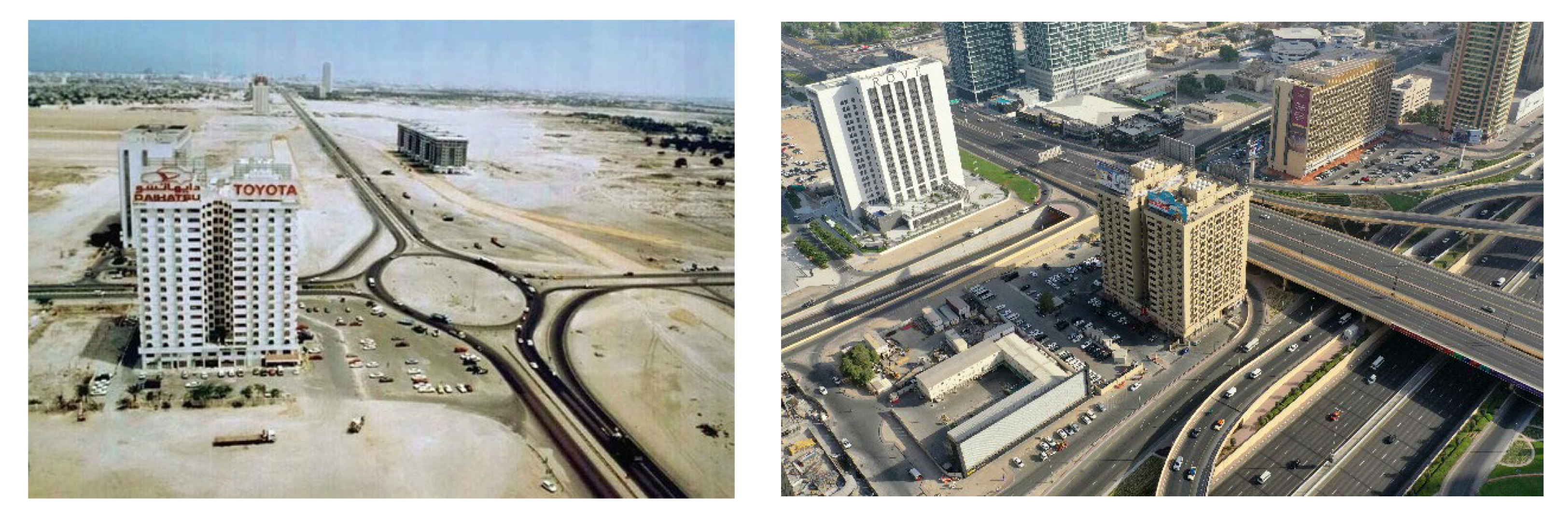
By its longstanding presence on Sheikh Zayed Road, its slang name based on the famous rooftop “Toyota” sign, and its status as one of the city’s first residential towers during the post-oil modernization era, this paper examines how the Toyota Building adds to the collective memory of Dubai. The Toyota Building, also officially the Nasser Rashid Lootah Building, was finished in 1974, merely three years after the United Arab Emirates came into being. It was built by Nasser Lootah Real Estate, as attested by documents pertaining to urban property. Although there are no unequivocally documented records identifying the architect, its appearance is an example of the rectilinear and functionalist architectural style common in early 1970s Dubai—an era of frenzied modernization in the aftermath of the oil boom. Built originally as a 15-story apartment block with commercial shops on the ground floor, it continues to be so today. Although the area, formerly known as Defense Roundabout, has been extensively remapped into the busy Sheikh Zayed Road freeway interchange, the building itself is still quite intact, still standing in its original form and function. This research focuses on the iconic exterior of the building to understand how existing buildings are dealt with in view of modernization in this city in a time of rapid economic and social change. The Toyota building zone is shown in
Figure 1.
This study employs three related research questions: in the context of fast-developing cities such as Dubai, how can cost effective digital documentation support the recognition and preservation of unprotected modern heritage; what are the operational benefits and constraints for employing both drone and land-based photogrammetry when documenting contemporary high-rise structures in complex urban settings; and how can digital documentation techniques help to raise public and institutional awareness of Dubai’s endangered modern architectural heritage? This research aims to contribute to the emerging body of work that addresses the disconnection between the availability of advanced digital tools and their limited application to modern architecture, particularly in buildings that have not yet been formally recognized as heritage. The Toyota Building was chosen as a case study for this research as one of the representative examples of early modern architecture in Dubai. The modern features of the building are mostly recognizable in its exterior, namely in the use of exposed concrete, geometric façade articulation, repetitive window patterns, and the overall verticality that reflects modernist principles adapted to the Gulf context. Completed in 1974, the Toyota Building is part of the first generation of Dubai high-rises. It was built in the middle of the desert in the area that was known later as “Defense Roundabout”. Since Dubai quickly developed around it, the Toyota Building is now situated in the center of the city, with a strategic location on Sheikh Zayed Road. The typical roundabout was replaced by a spaghetti junction, as shown in
Figure 2, indicating the massive transformation of the city.
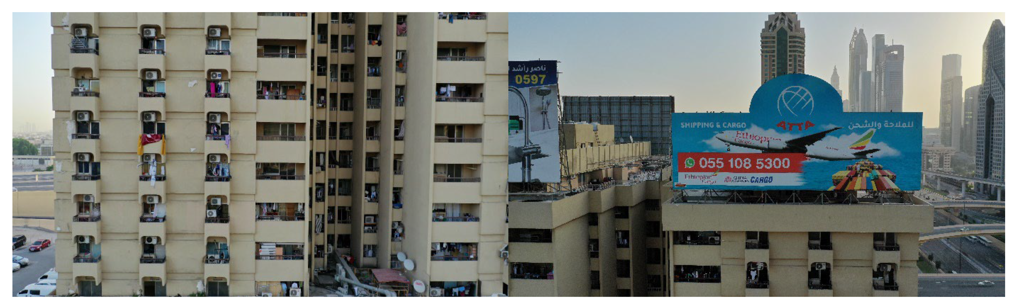
The massive concrete residential block has 15 stories with only small windows, designed to withstand the heat. The building’s color was changed from white to sandy in 2017, and in 2018, the flashing neon Toyota sign was removed after the advertising contract ended. A new sign was installed, replacing the one that had defined the building’s identity for decades, as shown in
Figure 3. The various stages of the Toyota Building’s exterior transformation over time are summarized in
Figure 4. Looking at the scene of Dubai, the Toyota Building is still struggling to survive, and its size seems to dwindle among the skyscrapers that loom in Dubai’s skyline. The ongoing evolution in its urban context and cultural associations renders the Toyota Building a pertinent topic for the examination of challenges and possibilities concerning the digital documentation of unprotected heritage. In this study, the term modern heritage refers broadly to buildings and urban elements of cultural, architectural, or historical significance from the post-oil era, particularly those not yet formally listed or protected, but increasingly recognized for their role in shaping collective memory and urban identity. More specifically, modern architectural heritage is used throughout this article to emphasize the design and architectural value of structures built between the 1960s and 1980s. While these indicate growing recognition of the country’s modern heritage, most listed buildings still lack formal legal protection. To our knowledge, as of 2024, no modern building in the UAE has yet received a binding conservation status under national heritage law.
2. Background and Literature Review
To address the central research question of utilizing digital technologies for supporting the identification and digital recording of unprotected modern heritage in Dubai. The term “low-cost” in this research includes something beyond cost savings—it is the confluence of accessibility, low technical burden, reduced labor, and high replicability. Unlike the LiDAR or TLS methods, which require costly hardware, trained operators, and limited access to sites, this procedure utilizes readily available tools such as DJI drones and DSLR cameras and off-the-shelf software. This setup slashes the personnel required and the on-site time significantly—crucial advantages in high-density cities like Sheikh Zayed Road, where logistical and regulatory complexities make large-scale equipment untenable. In a rapidly evolving urban setting such as Dubai, where modern buildings are often modified or destroyed without their historical significance being evaluated first, readily available tools such as drone-based photogrammetry and ground photography represent a feasible way to document threatened high-rise buildings prior to their alteration. The documentation urgency, coupled with restricted site access and other regulatory restrictions, renders these tools especially suitable for this context.
2.1. Overview of Heritage Documentation Techniques
Documenting buildings with cultural significance can be accomplished by a variety of methods. The selection of a specific method for documenting (heritage) buildings varies from one case to another [
9]. Architectural drawings, images, and photos were considered suitable for documenting the physical conditions of selected historic houses in the Old Town area of Ras Al Khaimah [
10]. Modern photogrammetric methods, including terrestrial laser scanning (TLS) photogrammetry [
11,
12] and light detection and ranging (LiDAR) [
13] have become important tools in the investigation and restoration of historic objects, buildings, and sites. Recent advancements also explore the integration of photogrammetry-derived models into HBIM platforms, enabling parametric modeling and long-term digital asset management [
14].
Documentation entails the systematic collection and archiving of records about heritage assets in order to preserve them [
15]. Digital documentation is a vital element in a comprehensive strategy to protect cultural heritage. A systematic data collection and registration process that identifies the history of a building, its architectural attributes, and the current state of preservation as well as any alterations that may have occurred throughout its lifetime are essential to its sustainable management and conservation [
16]. Remote sensing techniques, along with traditional archaeological research and prospection methods, are used to collect data that can be made available online. Several authors discussed and analyzed documentation techniques for modern heritage buildings, addressing their potential and constraints [
17,
18,
19]. According to Yang et al. [
20], the digital documentation of modern heritage involves modeling the geometry in 3D (most commonly using 3D computer graphics, photogrammetry, and laser scanning techniques) and managing semantic knowledge (in the form of geographic information systems (GIS) and ontology tools). This aligns with HBIM workflows that emphasize semantic enrichment and interdisciplinary collaboration for conservation planning [
21]. Digital photogrammetry can produce 3D models from reconstructed point clouds and can also produce high-resolution textures [
22]. Architectural heritage documentation requires extensive knowledge of the building history, physical condition, and social, political, economic, and cultural issues related to the external environment [
23].
2.2. Integrating Semantic Data Through HBIM
There are several nonprofit organizations in the field of heritage documentation. DOCOMOMO International, which has local working parties in over 80 regions and is probably most known for its conservation and documentation efforts of modern buildings, neighborhoods, and sites [
24]. DOCOMOMO’s and other nongovernmental organizations’ efforts, as well as pioneering digital documentation studies, are needed since modern heritage continues to be under-recognized, under-protected, and heavily threatened with demolition, especially in fast-developing cities. Their combined efforts are essential in acknowledging architectural value, raising awareness, and producing records that foster a sense of permanence and continuity amid rapid urban transformation. HBIM has increasingly been recognized as a key tool in these efforts—particularly for modern and contemporary buildings, which often lack comprehensive as-built records due to their mass-produced nature, standardized designs, or limited archival recording. While older historic buildings may also suffer from documentation gaps, they often receive more attention through formal conservation programs, whereas many modern structures remain unprotected, undocumented, and at risk of alteration or demolition. Though most contemporary buildings possess original schematics, the drawings are generally not available, out-of-date, or incomplete when compared to the building in its current state. HBIM is increasingly seen as a strategic tool for integrating semantic information, material history, and use layers in addition to reconstructing geometry. This is especially helpful for modern architecture, where buildings are more likely to be reused, adapted, or redeveloped, and heritage value is frequently disputed. In such cases, a digital model is not only important for documentation but also supports future planning, stakeholder coordination, and informed intervention strategies [
25]. In recent years, numerous researchers [
26,
27,
28,
29,
30] have used different digital technologies to document heritage in general and modern heritage buildings in particular. These studies highlight the growing relevance of hybrid digital workflows, combinations of photogrammetry, laser scanning, HBIM modeling, and GIS integration that prioritize that combine accessibility, accuracy, and adaptability to diverse building types and contexts [
31]. China’s built heritage, built environment, and cultural landscapes less than 50 years old are analyzed for their current state of conservation and potential threats [
30]. In Saudi Arabia, over 1300 potential modern heritage buildings were identified and categorized into typological groups and building types that historians, architects, planners, designers, and policymakers can use to document and present Saudi Arabia’s rich modern heritage effectively [
32].
Façade-only HBIM approaches are well-established in the literature. A case in point is the Baroque Palazzo in Italy that generated semantic HBIM models of façade elements to study historic grammar and ornament typologies without the need for interior access [
33]. Likewise, the Palermo villa project implemented scan-to-BIM workflows to model and survey the monumental façade of an 18th-century structure, with attention to exterior material decay and conservation data only [
34]. They improve the methodological rigor and cultural applicability of façade-based HBIM in instances where complete access is not possible.
2.3. Regional Case Studies and Institutional Frameworks
In the United Arab Emirates (UAE), studies were conducted to emphasize the importance of creating detailed base records to address the variety of documentation needs, including archaeological sites, cultural landscapes, and historic buildings, while preserving the built heritage in Abu Dhabi. As part of these efforts, Abu Dhabi’s Conservation Department developed a methodology to choose the appropriate tools and techniques to collect, analyze, and manage records as a function of the various building and site types [
35]. The review of inventoried buildings and understanding of the historic context enables a preliminary evaluation of significance that will allow future generations to comprehend the achievements of the modern phase of the emirate. Ultimately, the Abu Dhabi initiative aims to develop policies, strategies, and economic incentives that will protect and promote these resources in the long run. Graphs, documents, and photographs are being collected to provide insight into the historic urban environment and to establish criteria for assessing significance. By preserving the built heritage in Abu Dhabi, tangible and recognizable landmarks become a physical, spatial, and temporal anchor, connecting the past, present, and future while providing a context for collective memory and identity [
36]. Another study that considered Dubai as a case study [
37] implemented digital heritage documentation and its technologies to assess their potential for governmental and educational applications and to analyze existing projects. The study aimed to enhance the understanding and development of digital heritage as well as to establish new frameworks and perspectives for the preservation of traditional heritage.
These examples reveal the growing institutional and academic interest in documentation as a foundation for protecting not only traditional heritage but also emerging modern architectural heritage, especially in the Gulf region. Recent contributions also emphasize the integration of HBIM with virtual reality (VR) and GIS platforms to enhance spatial analytics, immersive education, and interactive heritage mapping [
38].
Recent studies on scan-to-BIM workflows have progressively emphasized the adjustment of workflows for restricted- or limited-access environments—conditions widespread in the modern urban setting. Tini et al. [
39] presented a scan-to-HBIM-to-VR workflow specifically customized for industrial heritage sites characterized by poor visibility, highlighting the importance of reusability and semantic correctness. Aricò, Lo Brutto, and Maltese [
40] conceived a knowledge-based segmentation approach to Arab-Norman heritage buildings to illustrate the feasibility of constructing HBIM with lacking data via typological intelligence. Simultaneously, Buldo et al. [
41] enhanced automatic segmentation techniques for masonry vaults through the application of parametric adaptation, an approach that is translatable to contemporary geometries as well. Patil and Kalantari [
42] also demonstrated that accurate wall reconstruction is possible using AI-assisted hybrid workflows even under erroneous semantic segmentation. The collective evidence of the studies above confirms the viability of streamlined, resource-minimal scan-to-BIM procedures—particularly applicable to projects like ours that have limited possibilities of complete interior access but prioritize typological precision, semantic coherence, and reproducibility.
2.4. Research Gap and Study Importance
As mentioned earlier, the preservation of modern architecture in a rapidly growing city like Dubai presents many challenges, including intergenerational value change, regulatory gaps, and competition from economic forces. As these structures fall outside the conventional heritage frameworks focusing on age and artistic values, they remain extremely vulnerable to redevelopment pressures.
To address these challenges, researchers have proposed HBIM methodologies tailored to modern architecture, aimed at improving data organization, accessibility, and long-term conservation planning [
43]. In line with this, the current research contributes to this discourse by documenting the Toyota Building using a photogrammetry-to-HBIM workflow, validated in the recent literature as both practical and scalable, particularly in resource-constrained contexts [
44]. The employed techniques—drone photogrammetry and ground-based photography—enabled the creation of a high-resolution, semantically structured 3D model, both as a technical tool and as a communication medium for heritage promotion. Being novel practices, the application of artificial intelligence (AI) for tasks such as element recognition and semantic labeling is regarded as an interesting avenue to boost documentation speed, consistency, and scalability [
45].
The produced workflow not only assures geometric precision but also facilitates future preservation—by recording the existing state of buildings—and supports conservation efforts through informed planning of repair and restoration. Additionally, it stimulates community participation and promotes educational use by documenting and categorizing the architectural elements that characterize Dubai’s identity. As the following section shows, the documentation of the Toyota Building applies this approach in practice, combining aerial and ground-based photogrammetry to create a comprehensive and accessible digital model.
While photogrammetry is an established technique of heritage documentation, its application has mostly been confined to historic, low-rise structures with rich architectural detail. This study puts a new spin by introducing drone-based photogrammetry and commercial 3D modeling software into the documentation of a modern high-rise structure.
This research demonstrates how cost-effective and easily accessible digital technologies can be used skillfully for preserving and conserving modern architectural heritage in rapidly transforming urban environments.
In addition, it presents a workflow especially tailored for buildings with flat façades and geometric regularity, thereby providing a model that can be replicated in similar instances throughout the Gulf and other fast-developing regions. In doing so, this research addresses a significant gap in the digital documentation of post-oil era architecture and promotes the value of documenting buildings that, while not formally designated as heritage, contribute meaningfully to the city’s cultural landscape and are increasingly at risk of demolition.
The term “low-cost” is used in a relative and practical sense. Compared to more resource-intensive methods such as terrestrial laser scanning (TLS) or LiDAR, which often require expensive hardware, larger teams, and highly specialized processing, our approach relies on commercially available equipment and accessible software. Although proprietary-based, tools like the DJI Phantom 4 Pro and RealityCapture offer an advantageous trade-off among cost-efficiency, image quality, and ease of use—of high value to research groups or institutions operating on limited budgets. Such a setup has demonstrated its adequacy for comprehensive documentation while maintaining reproducibility and scalability for analogous heritage material in low-resource environments.
While the photogrammetry-to-HBIM workflow used in this study is founded upon tested tools and methodologies, its importance lies in the contextual implementation of these processes on a building typology—unlisted modern high-rise buildings in Gulf cities—that is insufficiently documented. This building typology has particular documentation complexities, including limited access, legislative intricacy, and a lack of formal heritage policy. By adapting the process to these limitations, this research offers a reproducible and scalable solution that can possibly facilitate preinventory digital preservation in other dynamic city contexts.
3. Research Methodology
This research adopts a multiphase approach to digitally document a representative modern heritage high-rise building in Dubai using photogrammetry and accessible 3D modeling tools. The objective is to develop a replicable, cost-effective, and minimally intrusive workflow suited to the dense urban context of the Gulf. The digital documentation process is structured in four main phases. The workflow of the digital documentation process, including case study selection, recording, data processing, and HBIM integration, is illustrated in
Figure 5.
3.1. Case Study Selection and Site Investigation
The Toyota Building was selected as the case study for its architectural significance and status as a representative example of early high-rise residential development in Dubai. It was selected following a literature review of regional modern heritage, coupled with semistructured interviews with heritage professionals, government officials, and focus groups. Site visits were conducted in order to ascertain accessibility, visibility, and suitability for photogrammetric documentation. The Toyota Building was chosen not just due to its unique historical and cultural character, but also as a representative of the early modern high-rise residential architecture in the Dubai setting. Its modular façade, reinforced concrete, and overall form embody the design logic, material choices, and architectural language typical of post-oil modern buildings constructed across the UAE in the 1970s and 1980s. Thus, it is a model for a broader group of vulnerable high-rise buildings. The building was selected due to its symbolic value within Dubai’s post-oil urban history, high risk of alteration or demolition, and feasibility for full exterior documentation using aerial and ground-based imaging.
This research knowingly concentrated on the Toyota Building’s façade as the prerequisite initial step in documenting and analyzing the modern heritage in the Gulf region. Although access to the interior of the building was limited, the restriction did not influence the decision to undertake an exterior-based strategy. The façade was chosen because it is the most publicly visible and architecturally prominent element of the building. Its modern design language is expressed in form, materiality, rhythmic repetitions of windows, and balconies—features that enhance both its heritage value and presence in the urban skyline.
Notably, the façade takes on a central role in both the public and institutional recognition of heritage value. It is the first point of contact for both the general public and heritage regulatory authorities, positioning itself as a logical basis for raising awareness, appreciation, and potential designation.
Over the last half-century, the building’s evolution from an isolated structure in the desert into a highly visible aspect of Dubai’s tightly packed metropolitan setting is most clearly evident in its exterior appearance. Its landmark designation and iconic status are derived from its exterior and exterior detailing—features threatened progressively by the forces of redevelopment and rapid urban transformation. This study, therefore, presents an outside-first digital documentation strategy not as a limitation, but as a deliberate and thoughtful approach. We employed drone and ground-based photogrammetry to capture high-fidelity information for the complete exterior envelope to support semantic HBIM modelling. While we understand fully well the significance of internal documents and the multifaceted values these may possess, this study is an essential point of departure for the identification, cataloging, and analysis of the physical characteristics of modern high-rise structures in the UAE and the wider Gulf context.
The study was carried out by a multidisciplinary group comprising architectural heritage researchers, BIM and photogrammetry experts, UAV pilots, and heritage consultants. This ensured that procedures were standardized and in line with HBIM ideals, so that the data capture was accurate as well as modeling decisions that consider cultural sensitivity.
3.2. Recording and Data Collection
To ensure full façade coverage and geometrical accuracy, two complementary data acquisition methods were employed:
Aerial imaging
A DJI drone equipped with a 20-megapixel camera captured 447 high-resolution JPG images. These were taken using a planned flight path to ensure optimal lighting and overlap (minimum 5 images per surface) and embedded with GPS EXIF metadata for georeferencing. The ground sampling distance (GSD) of the aerial photography was approximately 0.82 cm/pixel, derived from the 13.2 mm sensor width, 8.8 mm focal length, and 30-m average flight altitude. The resolution was sufficient enough to capture architectural details such as balcony projections and window frames. For terrestrial photogrammetry, the Nikon Z7 (35.9 mm full-frame sensor) equipped with a 16 mm lens was employed to capture images at a distance of about 5 m from the building, resulting in a GSD of 0.14 cm/pixel. This permitted detailed recording of the lower façade areas and commercial entrances at high visual resolution.
Ground imaging
A 60-megapixel sensor Nikon camera with a fixed wide-angle 16 mm lens was utilized to capture a total of 368 sections of lower façades that were not easily visible through aerial photography. Supporting videos and panoramic photographs were also captured to facilitate the visualization and dissemination of the documentation. This composite approach provided total protection to the building.
3.3. Data Analysis, Processing, and Model Generation
Following photo selection and evaluation, 3D reconstruction was carried out using RealityCapture software v1.5. The basic processing steps were:
Alignment of images and generation of a sparse point cloud.
Creation of a dense point cloud consisting of tens of millions of points.
Mesh generation via surface triangulation.
Texture mapping from the original photographic dataset.
Orthophotos were generated directly within RealityCapture using the textured mesh and high-resolution source imagery, allowing for optimal image quality and spatial accuracy. These orthophotos were then exported for use in CAD and BIM workflows. While the final model was also exported in .OBJ format for archiving and visualization purposes, the orthophoto extraction process did not rely on the OBJ output, ensuring image fidelity.
3.4. HBIM Integration and Semantic Modeling
After generating the textured 3D model, the final phase involved organizing the geometric data into a structured, intelligent digital model using Autodesk Revit. The processed outputs were imported to allow for the generation of orthographic views for each façade and to initiate the development of a semantically enriched HBIM prototype.
The HBIM model developed in this research meets the level of development (LOD) 300, according to accepted BIM standards. These involve geometrically precise modeling of façade elements, including window modules, balconies, sign frames, and commercial base zones, thereby modeling their actual dimensions, spatial arrangement, and typological guidelines. While the model did not include more detailed construction or material specifications generally expected at levels of development (LOD) 400 or 500, it enables semantic enrichment and serves as a heritage documentation and planning tool.
The key aim of historical building information modeling (HBIM) does not involve reproducing conventional methods regarding heritage planning, typically concerned with geometric irregularities as well as complicated ornamentation, as specified by Historic England (2017) [
46] and CIPA/ICOMOS (2019) [
47] as well as building SMART standards for modeling (2020) [
48]. Instead, this research employs an HBIM methodology, modular, with a geometric foundation, tailored for modern architecture, normally characterized by flat façades and uniform volumetric grids as well as regular architectural motifs. Worth noting, however, is that such an approach depends on the building type and it might be insufficient for geometrically complicated types, e.g., concrete shells, expressive geometry, or composite structures appearing in the 1970s. A systematic HBIM procedure formulated in this research provides for façade element categorization (e.g., balconies and windows as well as signage) as well as for creating a supportive dataset with a potential future integration into automated recognition or machine learning. To promote a greater applicability for such a methodology, a typology study alongside systematic tuning would be required in order to ensure accurate representation as well as semantic comprehension.
4. HBIM Applications and Methodological Reflections
The HBIM workflow in this study prioritizes the establishment of a geometric and semantic basis that can be enhanced with additional layers of data. Fundamental elements modeled in Revit include façade modules and window systems; floor alignment; balcony projections; roofline; and signage. These were modeled according to data obtained from the photogrammetric model and matched with Revit families accordingly as deemed fit. The generated HBIM has several functions, like establishing a repeatable system for conducting future condition assessments, testing material, or damage mapping; facilitating the incorporation of previous inventories, city planning databases, or policy development tools; facilitating education and awareness through an accessible and editable framework for both students and professionals; and acting as a digital twin prototype, especially for buildings not yet listed as heritage and in danger of transformation or demolition.
The work faced constraints, including restricted drone usage, single-session data capture, and occasional objections to privacy on the ground for photography. Nevertheless, the process was able to capture a high-quality, complete digital model. The methodological framework established in this research is also scalable. It can be applied to similar structures in Dubai or other rapidly developing areas where modern architectural heritage faces the risk of erosion.
The scan-to-BIM conditions presented some limitations that guided the modeling process. They included partial side elevation occlusion by adjacent dense construction, surface texture anomalies caused by staged signage and maintenance interventions, and problems in guaranteeing geometric continuity between façade segments. To solve these, mesh-to-BIM translation favored typological simplification and semantic clarity over rigid geometric precision, in accordance with best practice for HBIM application to modern buildings.
5. Results and Discussion
This section presents the outcomes of the digital documentation of the Toyota Building, highlighting the effectiveness of aerial and terrestrial photogrammetry as well as the 3D modeling workflow leading to HBIM integration.
5.1. Image Acquisition and Coverage Strategy
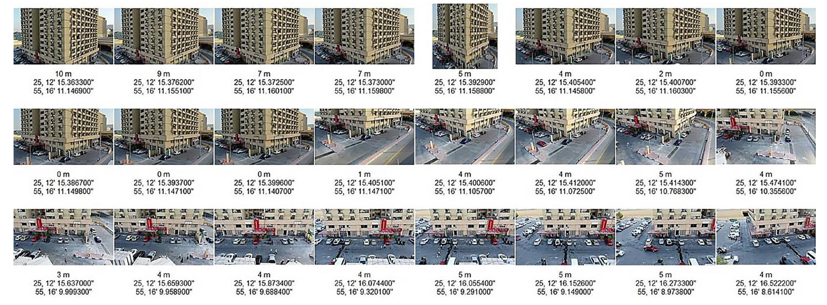
Three-dimensional recording was carried out through photogrammetry, selected over LiDAR and manual surveying due to its lower cost of equipment, having minimal staff needs, and ease of application. Photogrammetry can be performed using easily accessible cameras and software compared to LiDAR, which needs high-end scanners and specialized staff, hence proving to be ideal for heritage projects with cost limitations. Moreover, the use of drones for high-rise façade documentation reduces the need for physical access equipment or scaffolding, thereby helping to lower operational costs. The decision to utilize drone-based photogrammetry complemented by ground-based photographic techniques depended on a set of contextual and logistical factors. The structure is situated within a congested urban canyon off Sheikh Zayed Road, where large equipment setups—such as handheld or terrestrial laser scanning gear—were not feasible because of safety protocols, constrained sidewalk availability, and vehicular traffic. Moreover, the project aimed initially at developing a low-invasive and low-cost workflow, reproducible by urban teams or small-scale documentation projects. While advanced scanners would be capable of providing additional volumetric precision, the technique utilized was capable of producing a high-resolution 3D model sufficient for the semantic structuring of the façades, the ultimate goal of the research. As illustrated in
Figure 6, a total of 447 georeferenced aerial images were captured using a DJI drone equipped with a 20 MP camera. The images documented the building from multiple angles with sufficient overlap, and the flight paths were carefully planned with consideration of sunlight direction to ensure clear visibility and minimize shadows, as indicated. in
Figure 7.
In addition to the aerial photos, a Nikon camera equipped with a 60 MP sensor and 16 mm wide-angle lens was employed to capture 368 images at the ground level, targeting the lower façades and shopping entrances (
Figure 8). This hybrid system provided all-around vertical coverage with less visual distortion and no data gaps. The data processing using photogrammetry software is presented in
Figure 9.
5.2. Photogrammetric Processing and 3D Model Output
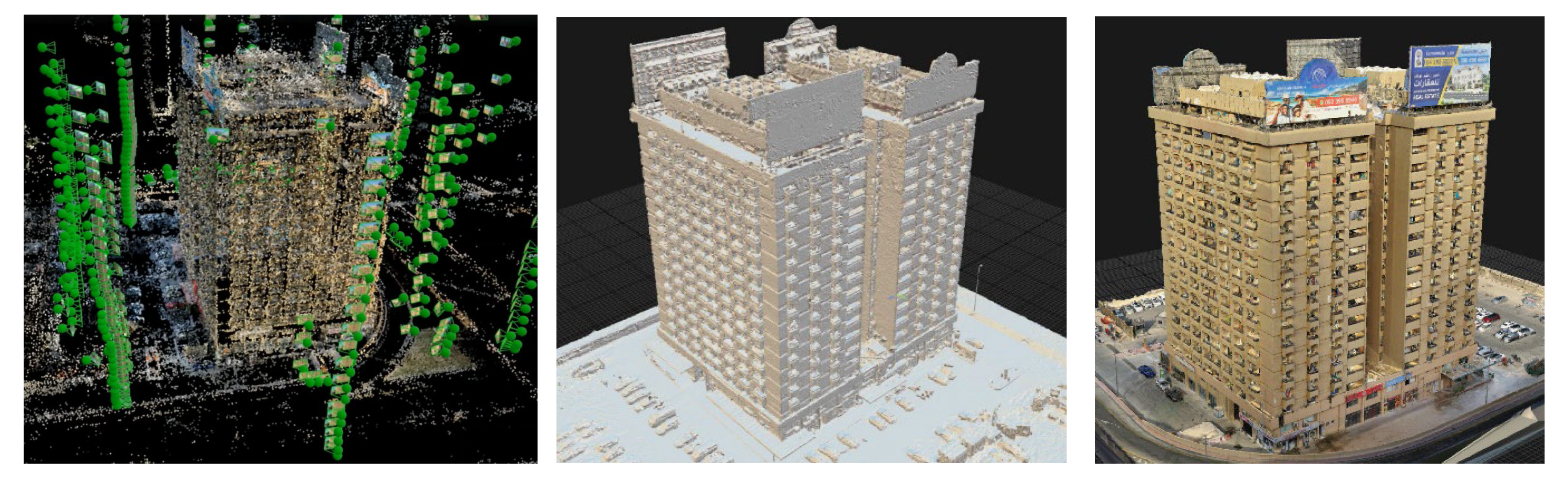
Photogrammetric processing was carried out with RealityCapture, resulting in the generation of a point cloud by automated image alignment, and subsequently a dense point cloud consisting of tens of millions of discrete points (
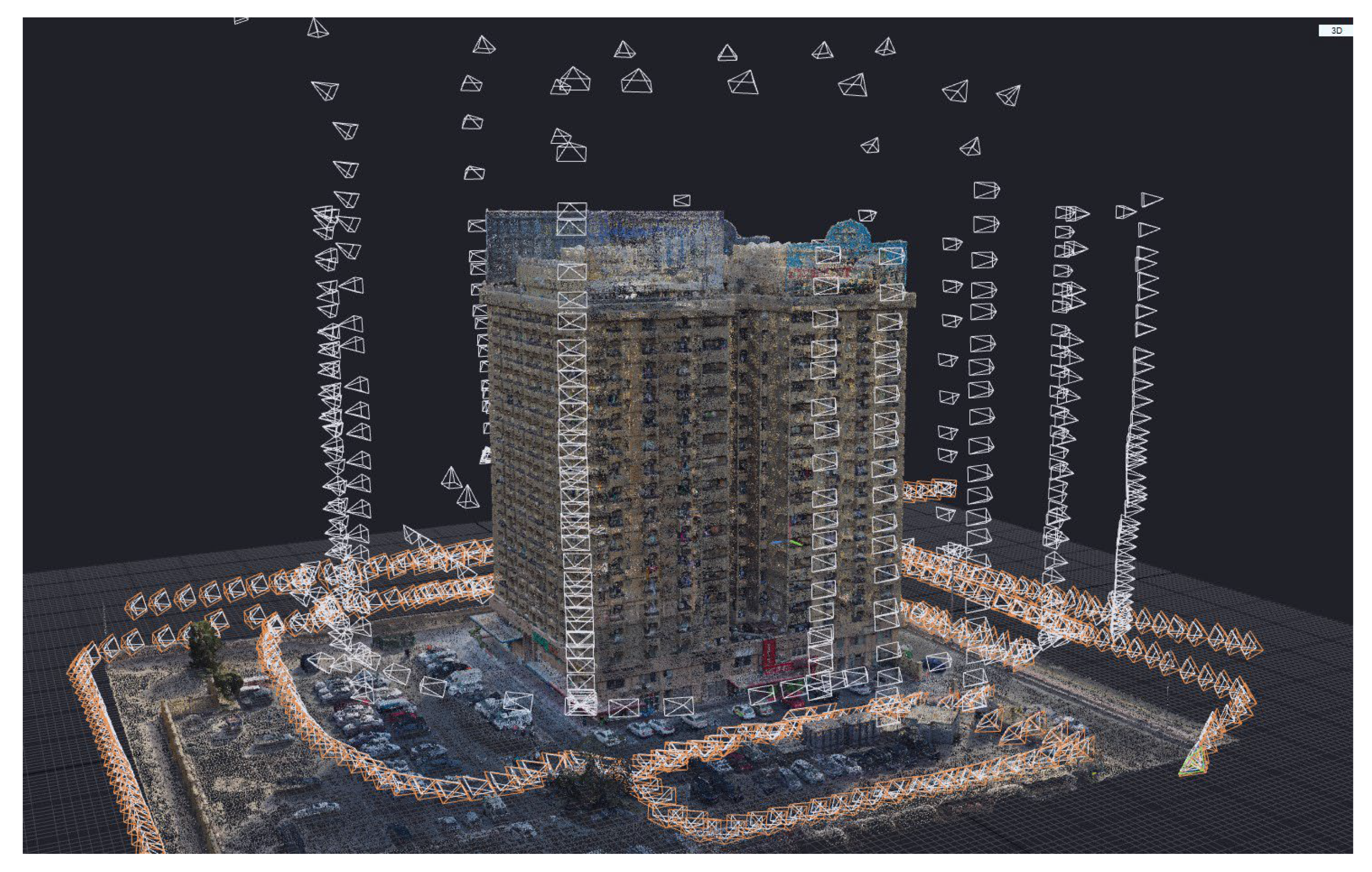
Figure 10). The image chains are indicative of vertical and overhead drone imagery, and the orange chains are representative of the hand-held imagery covering architectural details at ground level.
The point cloud was cleaned and meshed into a completely textured 3D model. From this, orthographic photos were extracted for each façade using CAD software (
Figure 11), providing the geometric basis for redrawing and further modeling. These orthophotos were imported into a BIM platform (Autodesk Revit), where an as-built architectural model of Toyota Building was established (
Figure 12).
The Toyota Building’s urban setting posed a number of challenges common to dense city environments, such as restricted take-off areas for drones, line-of-sight obstructions from neighboring skyscrapers, and restrictions on pedestrian-based ground photography due to traffic and privacy issues. Even with these constraints, complete façade coverage was achievable through the joint application of drone photogrammetry and handheld wide-angle photography. A predesigned flight route maintained vertical overlap and managed drone altitude to reduce occlusion. Ground-based images were purposely taken in open lines of sight to complete areas impenetrable to aerial imaging. The detailed 3D model and orthophotos extracted validate that the approach was resilient and versatile to intricate urban geometries, proving its feasibility for comparable high-rise buildings in dense metropolitan areas.
5.3. Image Interpretation and Annotation Support
While traditional photography and orthographic views help to make visual records, the large point cloud generated through photogrammetry provides a far more detailed and metric dataset. The point cloud accurately captures three-dimensional coordinates of every visible surface, allowing precise measurements, spatial alignment, and geometric analysis. Therefore, this ability allowed us to reconstruct constant balcony spacing floor by floor, identify planar irregularities, and confirm façade symmetry, despite the building’s age and surface deterioration. Significantly, the point cloud served as the background base upon which the development of the HBIM model was undertaken in Revit so that the project team could separate and categorize elements with as-built dimensional precision. This level of specificity and interoperability could not have been attained by visual documentation. Visual observation of the top-down and façade projections revealed the building’s symmetrical footprint, double-core internal circulation, and passive ventilation courtyards, characteristics of early Gulf modernism. The rooftop, as apparent in
Figure 6, was left largely empty except for the historical signage mounts, which further complemented the minimalist design of the building.
The façade orthographic drawings (
Figure 7,
Figure 8, and
Figure 11) reveal a modular and regular composition. The south and east elevations are made up of vertically stacked façade units, with recessed window modules and projecting balconies. A clearly identifiable commercial ground floor and mezzanine contrasts with the upper residential pattern, and the metal roof structures indicate the former existence of neon signage—a cultural signifier of the commercial nature of the building.
Such visual prompts facilitate the process of annotation in the HBIM context, in which modular repetition and structural simplicity make it easy to tag components and include metadata.
The present research deals with a high-rise building characterized by modular and rectilinear geometric forms; nonetheless, the methodology was conceived in consideration of analogous unclassified modern buildings that dot Gulf urban skylines. Note, however, that typologies like freeform concrete shells, dynamic geometries, or nonmodular structures present particular challenges in documentation. Bridging such challenges would require adopting alternative scanning techniques, segmentation strategies, and modeling frameworks. As such, the approach is introduced as a typology-specific solution for repetitive, flat façades, rather than a generic approach to the whole modern heritage category.
5.4. Semantic Feature Recognition and HBIM Structuring
Semantic segmentation of the 3D model allowed the documentation team to define key architectural elements as separate HBIM objects, as summarized in
Table 1. These included:
Window units are envisioned as parametric openings with depth and shadow attributes
Repeating families of balcony slabs and parapets
Differentiated pattern ground floor retail bays
Roof sign structures labeled as time-sensitive heritage features.
Table 1.
Semantic elements and their roles in structuring HBIM output.
Table 1.
Semantic elements and their roles in structuring HBIM output.
| Feature | Type | Repetition | Semantic Role in HBIM |
|---|
| Window unit | Opening | High | Base family for vertical stacking, alignment, and rhythm |
| Balcony module | Structural element | High | Shading, privacy, and floor articulation |
| Parapet | Safety feature | Consistent | Part of balcony and roof HBIM elements |
| Façade | Composite façade unit | High | Main modular unit for HBIM repetition |
| Commercial base zone | Mixed-use façade | Unique | Differentiated typology in HBIM |
| Rooftop signage frame | Steel frame | Unique | Time-sensitive, tagged as cultural/economic identifier |
| Circulation core | Inferred structural | Unique | For internal routing and vertical connections |
| Courtyard lightwell | Passive feature | Paired | Tagged as ventilation element in HBIM |
The semantic analysis enabled the generation of HBIM families that not just encapsulate geometric attributes but also functional typologies. This is particularly useful for mapping, recognition, and assessment of changes over time, and also for the inclusion of future material or condition survey layers. The semantic HBIM method used highlighted the classification and graphical definition of major façade elements based on their architectural geometry and functions. Recessed windows, balconies, railings, parapets, and other building elements were recognized using parametric criteria and clustered in the 3D model. A unique color was applied to each cluster in order to improve model readability and simplify the identification of elements. This color-coded segmentation proved to be effective in distinguishing the repetitive modules and unique architectural features. This enabled clear design logic communication and allowed for additional semantic annotation. To support the semantic classification process, high-resolution 3D views were generated and exported from Revit. As illustrated in
Figure 13, these views demonstrate the color-coded segmentation and parametric tagging of architectural elements. This process enhanced the model’s usability for both documentation and heritage analysis.
Beyond visual differentiation, BIM’s semantic structure enables multilevel data enrichment across categories, families, types, and instances. This enabled clustering of similar elements and mapping of their functional roles—such as shading (balconies), safety (parapets), or ventilation (recessed openings)—while keeping consistency in semantic label allocation across the façade. The resulting HBIM became a semantically enriched dataset suitable for heritage analysis and future restoration planning.
The outcomes show that this approach allows for a scalable and process-effective semantic modeling of heritage façades, combining parametric filtering, material-based visual coding, and hierarchical classification. The resulting semantic model allows modular studies of architectural elements, enables comparative research, and improves documentation quality in architectural typologies. It enhances HBIM’s usability in documenting situations where both geometric precision and semantic prosperity are critical for preserving architectural authenticity. This study also contributes to ongoing discussions regarding the adaptation of scan-to-BIM practice to sparse documentation contexts. The resultant HBIM model balances data fidelity and interpretive flexibility to facilitate typological abstraction in areas where image coverage or material condition data were poor. This aligns with the developing literature that favors pragmatic semantic modeling approaches in high-rise and modern contexts, where full 3D exposure is not always attainable. It should be noted that interior spaces were not documented, and the current HBIM model reflects only the external envelope and façade components. Future studies may incorporate interior spatial layouts and typological evolution if access to the building becomes feasible
This output goes beyond geometric documentation—it offers an expandable platform for marking heritage values, interpreting typological elements of Gulf modernism, and enabling networking for heritage advocacy. This approach aligns with emerging scholarship that sees digital heritage documentation not only as a means of recording physical attributes but also as a tool for cultural storytelling and stakeholder engagement. Fai et al. [
49] and López et al. [
50], for example, have shown how HBIM can be expanded to incorporate intangible values, usage patterns, and historical narratives into architectural models. Similarly, Murphy et al. [
51] and Oreni et al. [
52] have investigated how HBIM supports interpretive flexibility and layered analysis, especially in heritage contexts that require both accuracy and flexibility. This study contributes to this growing field by offering a replicable and resource-efficient methodology tailored to the under-documented typologies of Gulf modernism. The aim of digital documentation is to enable recognition of modern heritage, encourage multistakeholder dialogue, and raise community awareness of the endangered architectural heritage.
The produced documentation can serve as a means to promote Dubai’s modern heritage using museums and cultural initiatives. Furthermore, the digital models could be incorporated into augmented reality (AR) exhibitions or virtual heritage tours that align with the emirate’s smart tourism and cultural education strategies. Also, the HBIM models and photogrammetric content produced can serve as a teaching tool in architecture and heritage education courses. Moreover, the content can be formulated into interactive learning material that is incorporated within higher education courses to promote awareness of the significance of modern heritage.
The model incorporates foundational metadata for every typological feature to allow semantic classification and tagging according to its function within Gulf modernism. Although lacking lifecycle information or asset management data, the model in its present form caters to heritage-based uses and demonstrates a fundamental level of information (LOI) that is appropriate for typological identification and possible data enrichment.
Although this HBIM prototype primarily deals with exterior façades, its semantic framework enables the potential expansion to heritage management functions. Annotated objects like signage frames, balconies, and typological modules can be enriched with metadata concerning condition surveys, conservation stages, and policy development. This is in accordance with best practices where HBIM is not merely a geometric model but a methodically organized, interoperable platform for the stewardship and preservation of architectural heritage.
6. Conclusions and Future Work
Dubai’s modern architecture has its roots in the 1970s, following the discovery of oil. Sadly, these early modern high-rises are threatened by demolition due to rapid urbanization, commercial pressures, and rising land value. The digital documentation of modern buildings—particularly those not yet formally recognized as heritage—offers a foundation for recognition, interpretation, and potential conservation planning, but should not be considered preservation in itself.
The Toyota Building was selected as an iconic example of modern high-rise residential architecture in Dubai to demonstrate a low-cost, replicable documentation workflow. A combination of drone-based photogrammetry and ground photography was used to capture the building, with data processed using RealityCapture software. The resulting 3D model provided an accurate, high-resolution representation, which was then structured into a semantically enriched HBIM model using Autodesk Revit.
The Toyota Building embodies significant typological, spatial, and visual qualities pertinent to Dubai’s early high-rise development. This study illustrates the potential of widely available software not only for documenting geometry but also for interpreting, organizing, and contextualizing modern heritage through HBIM. It demonstrates how HBIM modeling and semantic segmentation can support automated recognition of architectural features in modern heritage buildings. These approaches help to address current gaps in heritage documentation, which still rely heavily on expert interpretation and manual identification of heritage attributes.
The methodology developed in this study creates a structured dataset that can support future applications in machine learning, pattern detection, and heritage asset management by classifying elements such as window units, balconies, and signage into HBIM families. This enables a methodical and scalable way of documenting buildings that are culturally significant but not officially listed.
The approach proposed here can be applied to other modern high-rise buildings across Dubai and the wider Gulf region, especially those undergoing redevelopment. The digital documentation of the Toyota Building can also be used in architectural curricula to enhance students’ awareness of the UAE’s modern heritage. Additionally, the 3D models form a foundation for a potential digital museum platform or dynamic repository for modern heritage buildings in the UAE.
The work presented here confirms the feasibility of developing a high-quality, semantic 3D model capable of connecting geometrical and historical surveys with descriptive thematic databases. In this way, HBIM becomes a comprehensive dataset encompassing multidisciplinary information, particularly supporting diverse documentation and intervention motivations.
Although the main focus of this paper was the technical documentation and semantic structuring of the Toyota Building, the outcomes provide several directions for future work. These include incorporating the models into virtual exhibitions, immersive learning environments, and interactive platforms to increase public awareness and engage stakeholders in heritage conservation. A plug-in is also under development to support the semiautomated integration of identified semantic features into HBIM environments.
It must also be noted that while this study offers a replicable workflow for documenting modern high-rise typologies in constrained urban contexts, its generalization to other categories of modern heritage (e.g., concrete shell structures or freeform geometries) requires caution. A typological assessment should precede the selection of documentation methods to ensure geometric fidelity, semantic mapping accuracy, and heritage management relevance.
Author Contributions
Conceptualization, A.A.R.; methodology, A.A.R.; software, A.A.R.; validation, A.A.R.; formal analysis, A.A.R.; investigation, A.A.R.; writing—original draft preparation, A.A.R.; writing—review and editing, A.A.R., W.Q. and U.P.; visualization, A.A.R.; supervision, U.P. and W.Q.; project administration, A.A.R.; funding acquisition, A.A.R. All authors have read and agreed to the published version of the manuscript.
Funding
This research was funded by American University of Ras Al Khaimah, the Office of Research and Community Service, grant number [ENGR/003/21]. The APC was funded by Delft University of Technology.
Data Availability Statement
Data is contained within the article.
Acknowledgments
We would like to show our gratitude to American University of Ras Al Khaimah, for their support in conducting this research. Also, we would like to thank ICCROM, Sharjah branch, Dubai Police, and Dubai Municipality, Architecture Heritage and Antiquities Department for their support in this research.
Conflicts of Interest
The authors declare no conflict of interest.
References
- Inayat, S. Uncommon Dubai+; Uncommon Ltd. and Individual Contributors: London, UK, 2018. [Google Scholar]
- Rogers, A.P. Built Heritage and Development: Heritage Impact Assessment of Change in Asia. Built Herit. 2017, 1, 16–28. [Google Scholar] [CrossRef]
- Turgut Gültekin, N. Evaluation of the Conservation of Modern Architectural Heritage through Ankara’s Public Buildings. IOP Conf. Ser. Mater. Sci. Eng. 2017, 245, 082046. [Google Scholar] [CrossRef]
- Bayyati, A.M. Geo Digital Documentation (GDD) for Arab and Islamic Heritage Preservation. Int. J. Geomat. Geosci. 2014, 2, 1–15. [Google Scholar]
- Baik, A.; Alitany, A. From Architectural Photogrammetry Toward Digital Architectural Heritage Education. Int. Arch. Photogramm. Remote Sens. Spat. Inf. Sci. 2018, XLII-2, 49–54. [Google Scholar] [CrossRef]
- Kolay, S. Cultural Heritage Preservation of Traditional Indian Art through Virtual New-media. Procedia—Soc. Behav. Sci. 2016, 225, 309–320. [Google Scholar] [CrossRef]
- Cimadomo, G. Documentation and dissemination of Cultural Heritage: Current solutions and considerations about its digital implementation. In Proceedings of the 2013 Digital Heritage International Congress (DigitalHeritage), Marseille, France, 28 October–1 November 2013; pp. 555–562. [Google Scholar] [CrossRef]
- Khalil, A.; Stravoravdis, S.; Backes, D. Categorisation of building data in the digital documentation of heritage buildings. Appl. Geomat. 2020, 13, 29–54. [Google Scholar] [CrossRef]
- Baik, A.; Almaimani, A.; Al-Amodi, M.; Rahaman, K.R. Applying digital methods for documenting heritage building in Old Jeddah: A case study of Hazzazi House. Digit. Appl. Archaeol. Cult. Herit. 2021, 21, e00189. [Google Scholar] [CrossRef]
- Abuhantash, T.; Al Assi, E.; Abu Ra’ed, A. Raising Awareness of Cultural Heritage: Experiential Learning, Architecture Education, and Documentation of Historical Architecture in Ras Al Khaimah; Al Qasimi Foundation: Ras Al-Khaimah, United Arab Emirates, 2020. [Google Scholar] [CrossRef]
- Tobiasz, A.; Markiewicz, J.; Łapiński, S.; Nikel, J.; Kot, P.; Muradov, M. Review of Methods for Documentation, Management, and Sustainability of Cultural Heritage. Case Study: Museum of King Jan III’s Palace at Wilanów. Sustainability 2019, 11, 7046. [Google Scholar] [CrossRef]
- Pesci, A.; Bonali, E.; Galli, C.; Boschi, E. Laser scanning and digital imaging for the investigation of an ancient building: Palazzo d’Accursio study case (Bologna, Italy). J. Cult. Herit. 2012, 13, 215–220. [Google Scholar] [CrossRef]
- Cheng, L.; Wang, Y.; Chen, Y.; Li, M. Using LiDAR for digital documentation of ancient city walls. J. Cult. Herit. 2016, 17, 188–193. [Google Scholar] [CrossRef]
- Previtali, M.; Brumana, R.; Stanga, C.; Banfi, F. An Ontology-Based Repre-sentation of Vaulted System for HBIM. Appl. Sci. 2020, 10, 1377. [Google Scholar] [CrossRef]
- Robin, L.; Schmid, W.; LeBlanc, F. Recording, Documentation, and Information Management for the Conservation of Heritage Places: Guiding Principles; Getty Conservation Institute: Los Angeles, CA, USA, 2007. [Google Scholar]
- Kioussi, A.; Karoglou, M.; Labropoulos, K.; Bakolas, A.; Moropoulou, A. Integrated documentation protocols enabling decision making in cultural heritage protection. J. Cult. Herit. 2013, 14, e141–e146. [Google Scholar] [CrossRef]
- Hassani, F. Documentation of Cultural Heritage Techniques, Potentials and Constraints, the International Archives of the Photogrammetry, Remote Sensing and Spatial Information Science. In Proceedings of the 2015 25th International CIPA Symposium 2015, Taipei, Taiwan, 31 August–4 September 2015; Volume XL-5/W7. [Google Scholar]
- Preti, P.; Tituana, K.; Carvallo, J.; Heras, V. Digital Heritage Documentation of Modern Architecture in Cuenca-Ecuador. Int. Arch. Photogramm. Remote Sens. Spat. Inf. Sci. 2019, XLII-2/W15, 937–943. [Google Scholar] [CrossRef]
- Sheldrick, N.; Zerbini, A. A Heritage Inventory for Documenting Endangered Archaeology in the Middle East and North Africa, ISPRS Annals of the Photogrammetry, Remote Sensing and Spatial Information Sciences. In Proceedings of the 2017 26th International CIPA Symposium 2017, Ottawa, Canada, 28 August–1 September 2017; Volume IV-2/W2. [Google Scholar]
- Yang, X.; Grussenmeyer, P.; Koehl, M.; Macher, H.; Murtiyoso, A.; Landes, T. Review of built heritage modelling: Integration of HBIM and other information techniques. J. Cult. Herit. 2020, 46, 350–360. [Google Scholar] [CrossRef]
- Volk, R.; Stengel, J.; Schultmann, F. Building Information Modeling (BIM) for existing buildings—Literature review and future needs. Autom. Constr. 2019, 38, 109–127. [Google Scholar] [CrossRef]
- Hassan, A.T.; Fritsch, D. Integration of Laser Scanning and Photogrammetry in 3D/4D Cultural Heritage Preservation–A Review. Int. J. Appl. 2019, 9, 16. [Google Scholar]
- Simeone, D.; Cursi, S.; Toldo, I.; Carrara, G. BIM and knowledge management for Building Heritage. In Proceedings of the 34th Annual Conference of the Association for Computer Aided Design in Architecture (ACADIA), Los Angeles, CA, USA, 23–25 October 2014; pp. 681–690. [Google Scholar]
- Ballice, G.; Paykoç, E.; Güler, G. Documenting Modern Interiors using Digital Technologies: Mid-Century Apartment Buildings in İzmir. In New Approaches in Contemporary Architecture and Urbanism; Cinius Yayınları: Istanbul, Türkiye, 2020; p. 11. [Google Scholar]
- Saygi, G.; Remondino, F. Management of architectural heritage information in BIM and GIS: State-of-the-art and future perspectives. Int. J. Herit. Digit. Era 2013, 2, 695–713. [Google Scholar] [CrossRef]
- Alshawabkeh, Y.; El-Khalili, M.; Almasri, E.; Bala’awi, F.; Al-Massarweh, A. Heritage documentation using laser scanner and photogrammetry. The case study of Qasr Al-Abidit, Jordan. Digit. Appl. Archaeol. Cult. Herit. 2020, 16, e00133. [Google Scholar] [CrossRef]
- Yastikli, N. Documentation of cultural heritage using digital photogrammetry and laser scanning. J. Cult. Herit. 2007, 8, 423–427. [Google Scholar] [CrossRef]
- Reina Ortiz, M.; Santana Quintero, M.; Vernaza, C.; Ramírez, P.; Montejo Gaitán, F.; Segura Escobar, J. Capacity building for the documentation and conservation of Latin American cultural heritage: Making technology accessible and sustainable. J. Cult. Herit. Manag. Sustain. Dev. 2021, 11, 155–169. [Google Scholar] [CrossRef]
- Darier, L.; El-Darier, L.E.D.; Hassan, S.; Al-Abassy, D. The Influence of Technological Development on the Sustainability of Architectural Heritage (Documentation and Preservation)—Case Study: Citadel of Qaitbay. Int. J. Multidiscip. Stud. Archit. Cult. Herit. 2018, 1, 28–58. [Google Scholar] [CrossRef]
- Zhang, S. The Preservation of 20th-Century Architectural Heritage in China: Evolution and Prospects. Built Herit. 2018, 2, 4–16. [Google Scholar] [CrossRef]
- García-León, J.; Murrieri, P.; Collado-Espejo, P.E. HBIM as a Tool for the Analysis and Conservation of Architectural Heritage: Case Study: The Rame Tower’s Digital Twin. ISPRS Arch. 2023, XLVIII-M-2-2023, 637–644. [Google Scholar] [CrossRef]
- Alghamdi, N.; Alnaim, M.M.; Alotaibi, F.; Alzahrani, A.; Alosaimi, F.; Ajlan, A.; Alkhudhayri, Y.A.; Alshathri, A. Documenting Riyadh City’s significant modern heritage: A Methodological approach. Buildings 2023, 13, 2818. [Google Scholar] [CrossRef]
- Lo Turco, M.; Bono, J.; Tomalini, A. Parameters, modeling and taxonomy for an HBIM Baroque façade. Nexus Netw. J. 2024, 26, 609–630. [Google Scholar] [CrossRef]
- Ferro, A.; Lo Brutto, M.; Ventimiglia, G.M. A scan to BIM process for the monitoring and conservation of the architectural heritage: Integration of thematic information in a HBIM model. Int. Arch. Photogramm. Remote Sens. Spat. Inf. Sci. 2023, 48, 549–556. [Google Scholar] [CrossRef]
- Muhammad, S. Documentation and Monitoring of Built Heritage in Abu Dhabi, UAE, International Archives of the Photogrammetry, Remote Sensing and Spatial Information Sciences. In Proceedings of the 2013 XXIV International CIPA Symposium, Strasbourg, France, 2–6 September 2013; Volume XL-5/W2. [Google Scholar]
- Amel, C.; Hossam, M. Starting from scratch: Preserving Abu Dhabi’s modern heritage. In Proceedings of the International Conference Intervention Approaches for the 20th Century Architectural Heritage, Madrid, Spain, 14–16 June 2011. [Google Scholar]
- Alshaibah, A. Digital Heritage: Preservation of Architectural Heritage in the United Arab Emirates: Dubai as a Case Study. RES MILITARIS 2023, 13, 4130–4144. [Google Scholar]
- Fortunato, T.; Bruno, S.; Fatiguso, F.; De Fino, M. From GIS to HBIM and Back: Multiscale Performance and Condition Assessment for Networks of Public Heritage Buildings and Construction Components. Int. J. Archit. Herit. 2025, 1–25. [Google Scholar] [CrossRef]
- Tini, M.A.; Zerbini, A.; Rivaroli, L.; Fregonese, L. Scan-to-HBIM-to-VR: An integrated approach for the documentation of an industrial archaeology building. Remote Sens. 2024, 16, 2859. [Google Scholar] [CrossRef]
- Aricò, M.; Lo Brutto, M.; Maltese, A. A Scan-to-BIM approach for the management of two Arab-Norman churches in Palermo (Italy). Heritage 2023, 6, 1622–1644. [Google Scholar] [CrossRef]
- Buldo, M.; Barazzetti, L.; Banfi, F.; Previtali, M. A scan-to-BIM workflow proposal for cultural heritage: Automatic point cloud segmentation and parametric-adaptive modelling of vaulted systems. ISPRS Arch. Photogramm. Remote Sens. Spat. Inf. Sci. 2023, XLVIII-M-2-2023, 241–248. [Google Scholar] [CrossRef]
- Patil, A.; Kalantari, M. Automatic scan-to-BIM: The impact of semantic segmentation accuracy. Buildings 2025, 15, 1126. [Google Scholar] [CrossRef]
- Angulo, E.C.A. HBIM Methodology Applied to Architectural Heritage. Rev. Gestão Soc. E Ambient. 2024, 18, e09878. [Google Scholar] [CrossRef]
- Fazion, B.; Treccani, D.; Fregonese, L.; Lombardini, N. HBIM structural model to evaluate building evolution and construction hypotheses: Preliminary results. Int. Arch. Photogramm. Remote Sens. Spat. Inf. Sci. 2024, XLVIII-2/W4, 213–219. Available online: https://isprs-archives.copernicus.org/articles/XLVIII-2-W4-2024/213/2024/ (accessed on 8 May 2025). [CrossRef]
- Croce, V.; Caroti, G.; Piemonte, A.; De Luca, L.; Véron, P. H-BIM and Artificial Intelligence: Classification of Architectural Heritage for Semi-Automatic Scan-to-BIM Reconstruction. Sensors 2023, 23, 2497. [Google Scholar] [CrossRef]
- Historic England. 3D Laser Scanning for Heritage: Advice and Guidance. Historic England. 2017. Available online: https://historicengland.org.uk/images-books/publications/3d-laser-scanning-heritage2/ (accessed on 3 May 2025).
- International Council on Monuments and Sites (ICOMOS). Principles for the Recording of Monuments Groups of Buildings Sites, Adopted at the 11th ICOMOS General Assembly, Sofia, Bulgaria. 1996. Available online: https://www.icomos.org.tr/Dosyalar/ICOMOSTR_en0057762001587380182.pdf (accessed on 3 May 2025).
- buildingSMART International. Industry Foundation Classes (IFC) Documentation—Version 4.3. 2020. Available online: https://technical.buildingsmart.org/standards/ifc/ (accessed on 8 May 2025).
- Fai, S.; Graham, K.; Duckworth, T.; Wood, N.W.; Attar, R. Building Information Modelling and Heritage Documentation; CIPA Heritage Documentation: Paris, France, 2011. [Google Scholar]
- López, F.J.; Lerones, P.M.; Llamas, J.; Gómez-García-Bermejo, J.; Zalama, E. A review of heritage building information modeling (H-BIM). Multimodal Technol. Interact. 2018, 2, 21. [Google Scholar] [CrossRef]
- Murphy, M.; McGovern, E.; Pavia, S. Historic Building Information Modelling—Adding intelligence to laser and image-based surveys of European classical architecture. ISPRS J. Photogramm. Remote Sens. 2013, 76, 89–102. [Google Scholar] [CrossRef]
- Oreni, D.; Brumana, R.; Georgopoulos, A.; Cuca, B. HBIM for Conservation and Management of Built Heritage: Towards a Library of Vaults and Wooden Bean Floors. ISPRS Ann. Photogramm. Remote Sens. Spat. Inf. Sci. 2013, II-5/W1, 215–221. [Google Scholar] [CrossRef]
Figure 1.
Toyota Building Zone (source: author adapted from Internet resource: pinterest.com).
Figure 1.
Toyota Building Zone (source: author adapted from Internet resource: pinterest.com).
Figure 2.
Toyota Building “Defense Roundabout”—1974 (left) (Image credit: NRL Group), Toyota Building in Shaikh Zayed Road—2021 (right), © Author(s).
Figure 2.
Toyota Building “Defense Roundabout”—1974 (left) (Image credit: NRL Group), Toyota Building in Shaikh Zayed Road—2021 (right), © Author(s).
Figure 3.
The current state of the Toyota Building—2021, © author(s).
Figure 3.
The current state of the Toyota Building—2021, © author(s).
Figure 4.
The Toyota Building’s transformation timeline, © author(s).
Figure 4.
The Toyota Building’s transformation timeline, © author(s).
Figure 5.
Digital documentation workflow, © author(s).
Figure 5.
Digital documentation workflow, © author(s).
Figure 6.
Geographical position of each snapshot “in red” captured by DJI drone while scanning the building, © author(s).
Figure 6.
Geographical position of each snapshot “in red” captured by DJI drone while scanning the building, © author(s).
Figure 7.
A sample of a series of consecutive photos taken by a drone, and the location of the camera appears when each photo is taken, © author(s).
Figure 7.
A sample of a series of consecutive photos taken by a drone, and the location of the camera appears when each photo is taken, © author(s).
Figure 8.
A sample of a series of consecutive photos taken with the digital camera, the camera’s location changes slightly when each photo is taken, © author(s).
Figure 8.
A sample of a series of consecutive photos taken with the digital camera, the camera’s location changes slightly when each photo is taken, © author(s).
Figure 9.
Data processing using photogrammetry RealityCapture software, © author(s).
Figure 9.
Data processing using photogrammetry RealityCapture software, © author(s).
Figure 10.
Point cloud of the 3D model consist of DJI drone images captured along vertical chains from above. The ground-level images highlighted in orange focus on the building’s base, © author(s).
Figure 10.
Point cloud of the 3D model consist of DJI drone images captured along vertical chains from above. The ground-level images highlighted in orange focus on the building’s base, © author(s).
Figure 11.
Merging corrected images into CAD-software “orthographic images” © author(s).
Figure 11.
Merging corrected images into CAD-software “orthographic images” © author(s).
Figure 12.
Architecture model using Revit software, © author(s).
Figure 12.
Architecture model using Revit software, © author(s).
Figure 13.
Semantic HBIM segmentation and parametric element mapping in Revit for modern heritage documentation, © author(s).
Figure 13.
Semantic HBIM segmentation and parametric element mapping in Revit for modern heritage documentation, © author(s).
| Disclaimer/Publisher’s Note: The statements, opinions and data contained in all publications are solely those of the individual author(s) and contributor(s) and not of MDPI and/or the editor(s). MDPI and/or the editor(s) disclaim responsibility for any injury to people or property resulting from any ideas, methods, instructions or products referred to in the content. |
© 2025 by the authors. Licensee MDPI, Basel, Switzerland. This article is an open access article distributed under the terms and conditions of the Creative Commons Attribution (CC BY) license (https://creativecommons.org/licenses/by/4.0/).


