1. Introduction
The last decade has seen a considerable increase in the amount of literature devoted to the impact of climatic and environmental factors on the history and fate of the later Roman and Byzantine, or medieval Eastern Roman Empire. In part, this reflects a broader trend in history and archaeology to examine potential causal connections between climate and the evolution of human society over the long term, and especially during the Holocene. It also reflects an increasing availability and access to palaeoscientific resources that can be exploited to augment the traditional archaeological and historical documentation. But as we are all aware, this brings with it increased methodological challenges and the potential for the misuse or misunderstanding on the part of historians of what the palaeoscience data can tell us and what the limits are in their interpretation. In particular, the discussion around various forms of reductionist or deterministic argument has been very lively and led to often fierce disagreement among specialists. This is, of course, to be welcomed, because in order to make the best use of the available evidence, whatever its origins, there needs to be an open and honest debate about method and application [
1,
2,
3].
In light of this it is not surprising that the roles played by environmental factors (especially disease) and climatic factors (in particular drought and cooling), have come to the fore in recent accounts of the story of the collapse of the Roman Empire, one of the most popular tales of civilizational “decline and fall.” Especially prominent, for example, has been the role of the so-called Late Antique Little Ice Age, or LALIA, a period of summer cooling lasting about a century beginning ca. 536–539, which has been credited with a wide range of indirect and direct consequences, including the outbreak of the first pandemic of bubonic plague, and the dislocation of nomadic peoples on the Eurasian steppe consequent upon drought and unusually severe winters [
4,
5,
6]. The turbulent history of the eastern Roman world from the 6th to the 11th century (and beyond) is relatively well-documented, although there remain gaps and patchiness in the coverage of both the archaeological and written sources (e.g., [
7]). As with any other socio-ecological system, East Roman society and history need to be understood within the framework of their physical geography and climate, because climate change impacts different regions and micro-regions in different ways at different times, and these nuances are vitally important if we are to grasp the causal association between climate and social and environmental change [
8]. One of the most significant lessons to emerge from this research is that while changes in climate may have no negative impact on the economy and society of a pre-modern state, they may yet provide a context that facilitates a whole range of other societal transformations. The challenge is to integrate these climate data fully into the evidence for social, political, and cultural change. The discussion that follows offers an illustration of this.
In the following I will (1) briefly set out the historical context for the present discussion, followed by (2) an account of the evidence for climate conditions and climate changes for Anatolia across the period under discussion; (3) a discussion of the challenges associated with the proxy data for land-use and an account of what we know about land-use in central Anatolia between the 6th–7th and 11th c CE; (4) some comments on social, economic and administrative adaptive strategies, insofar as our evidence—archaeological, historical, and palaeoenvironmental—permits us to assess these; (5) two case studies illustrating the difficulties and uncertainties in interpreting the relationships between climate, environment, and societal change.
2. Historical Context
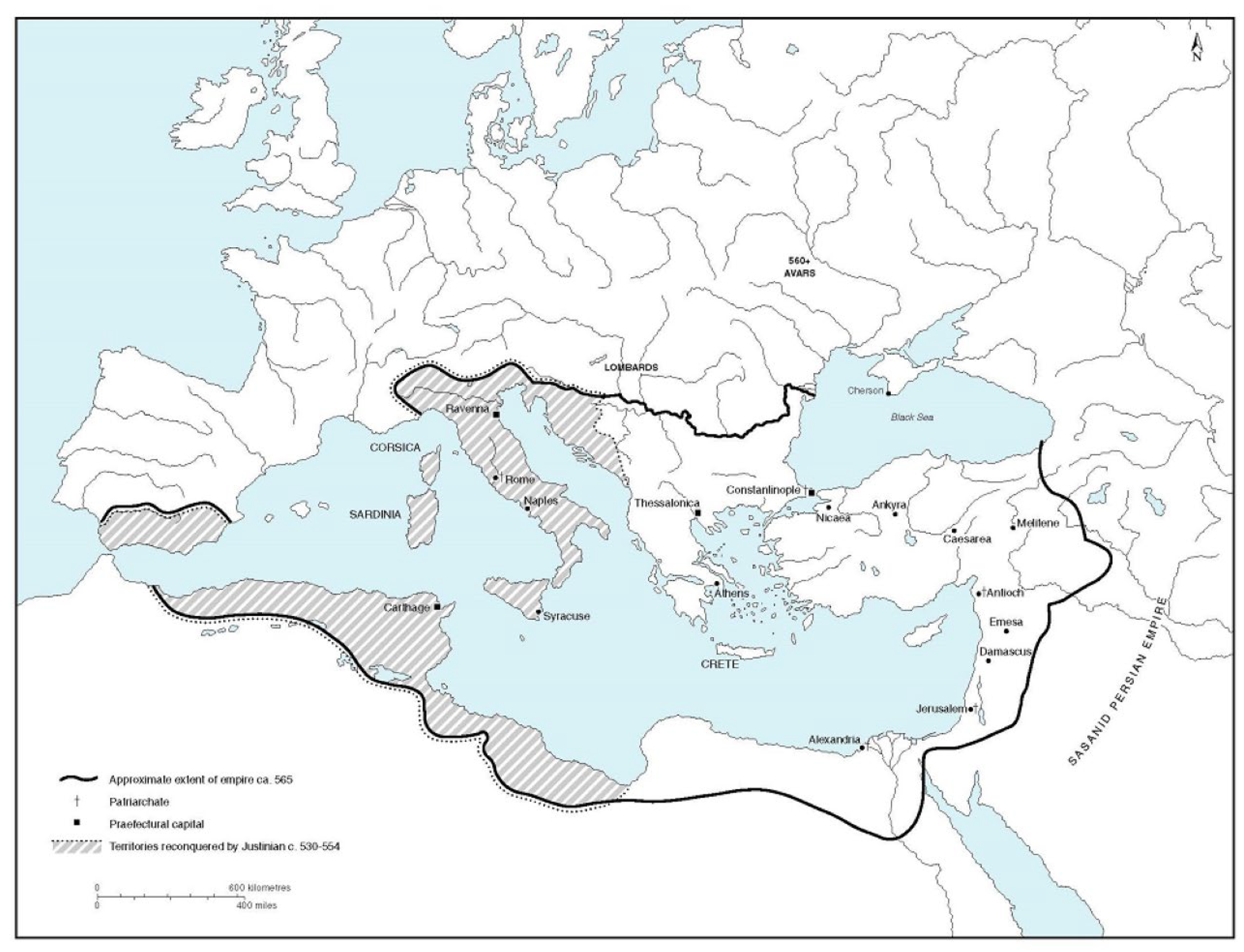
The East Roman state at its height in the middle of the 6th century was overextended. With its political center at Constantinople, it stretched as far west as the Balearic islands, across N. Africa as far as the straits of Gibraltar, and spanned most of Italy (with Sardinia, Corsica and Sicily) and the Balkans; in the east it included Egypt and greater Syria (modern Syria and N Iraq, much of Jordan, all of modern Israel and Lebanon) [
Figure 1]. But beginning already in the 560s, effective imperial authority over this huge territory began to contract [
7,
9]. The Germanic Lombards invaded and seized much of Italy from 568. Slavic and then Turkic invaders seized control of much of the Balkans between the 560s and mid-7th century; the Arabs seized the wealthiest provinces in the east—Egypt, Syria, and N. Iraq—between 634 and 642. This limited imperial control to the southern Balkan littoral, northern and western Anatolia, the central plateau, and the Aegean region. At the same time, the 7th-century invasions deprived the government at Constantinople of its wealthiest tax-generating resources. But it also reduced it to a hard, defensible core, focused on Constantinople with its triple walls and sea-defenses, protected by an Anatolian hinterland sheltered behind the Taurus and Anti-Taurus mountains in the south, penetration beyond which always eluded the Arabs, partly because of geographical, partly climatic conditions [
7,
10,
11,
12,
13] [
Figure 2]. In the course of the 8th and 9th centuries, the Empire was able to re-establish a degree of political parity with its Islamic and Balkan neighbors, and by the middle of the 11th century, become again the pre-eminent power in the E. Mediterranean. Although it suffered the loss of much of Anatolia from the 1070s onwards, until the 1180s it retained this position.
Weakened thereafter by internal discontent, elite internecine strife and provincial rebellion in parts of the Balkans, its dominance was ended by the 4th Crusade in 1203–1204, after which it was broken up into a series of smaller polities, many under western European control, until its extinction at the hands of the Ottomans in the middle of the 15th century [
14]. The pendulum of imperial recovery and failure swung dramatically across these centuries. Yet the Empire survived as an effective international power up to the end of the 12th century primarily because it retained throughout this period a powerful centralized political establishment; an elite that was never able to effectively challenge the center over the long term; an all-pervasive ideology of Empire embodied in the imperial church; good internal communications, and, crucially, a degree of systemic institutional redundancy that provided effective buffering at times of crisis.
While a great deal is now understood about the way the East Roman state functioned and how its institutions worked, little attention has until recently been paid to the potential role of shifts in climatic conditions in understanding either the causes or the configuration of the changes it underwent [
15]. In part, this is a response of historians within a relatively conservative discipline, at least in respect of social theory, to the potential for environmental or climate determinism. Such determinism or reductionism frequently creeps into historical analyses where data permits a clear assessment of climatic conditions, in particular where there exist correlations between significant historical developments and significant climatic events or trends (see most recently on this [
16]).
3. Climate
The climate history of the eastern Mediterranean-Middle East region across the centuries in question is a fundamental element in this picture [
8]. Anatolia presents a complex climate regime, with several contrasting patterns, a result of a combination of the collision of air masses from the North Atlantic, the Mediterranean Sea, and Eurasia, together with a widely diverse topography: plateau grasslands, forest, desert, and mountains. The seven climate regimes that result from this combination of factors are highly variable both spatially and across time [
17,
18]. Palaeoclimate and palaeoecological data from each of these, even if not always as chronologically refined as we would like, often show very different patterns of warm or cold, arid and moist conditions at the same times in different regions. Since the pattern of change was by no means uniform either chronologically or spatially, drawing causal associations between climate and the wider social, economic, and political evolution of the period is particularly challenging [
19,
20,
21].
It is possible to generalize, of course. In spite of such sub-regional variation, climatic conditions remained broadly stable across the wider Eastern Mediterranean zone until ca. 200 CE
, giving way thereafter to a greater degree of regional variation with higher-amplitude fluctuations between cold/dry and warm/wet periods. Before the 6th century, conditions were, in general, dry, with regional aridity being most marked during the 4th and 5th centuries [
22], [
23] (pp. 164–165), [
24] (pp. 191–202). In the decades around 500 CE, however, Mediterranean atmospheric circulation experienced some significant changes. Northern, central, and eastern Anatolia and the northern Levant became wetter, while other regions—including the Balkans, Greece, and southwest Anatolia, as well as southern Arabia—became somewhat more arid [
25] (Figure 1c,d). Thereafter, while central and western Anatolia, along with Thrace, present a very broad (centennial) degree of spatial coherence in temperature and precipitation, a significant improvement in humidity in the Constantinople region—as indicated by the Uzuntarla data (see below)—from the 740s onward contrasts with an increasingly arid climate in central and northern Anatolia from the same time [
26], [
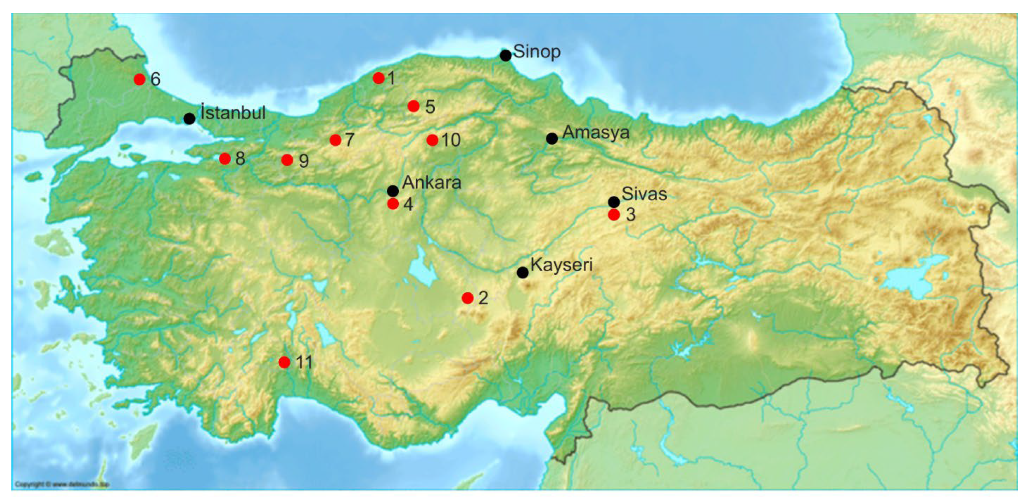
27] (pp. 130–131). Yet when we zoom into specific local data, the picture appears even more complex, potentially falsifying any conclusions drawn only at this broader level about the relationship between societal change and climate. Eleven sites across northwestern, northern, and central Anatolia provide useful indications of this complexity [
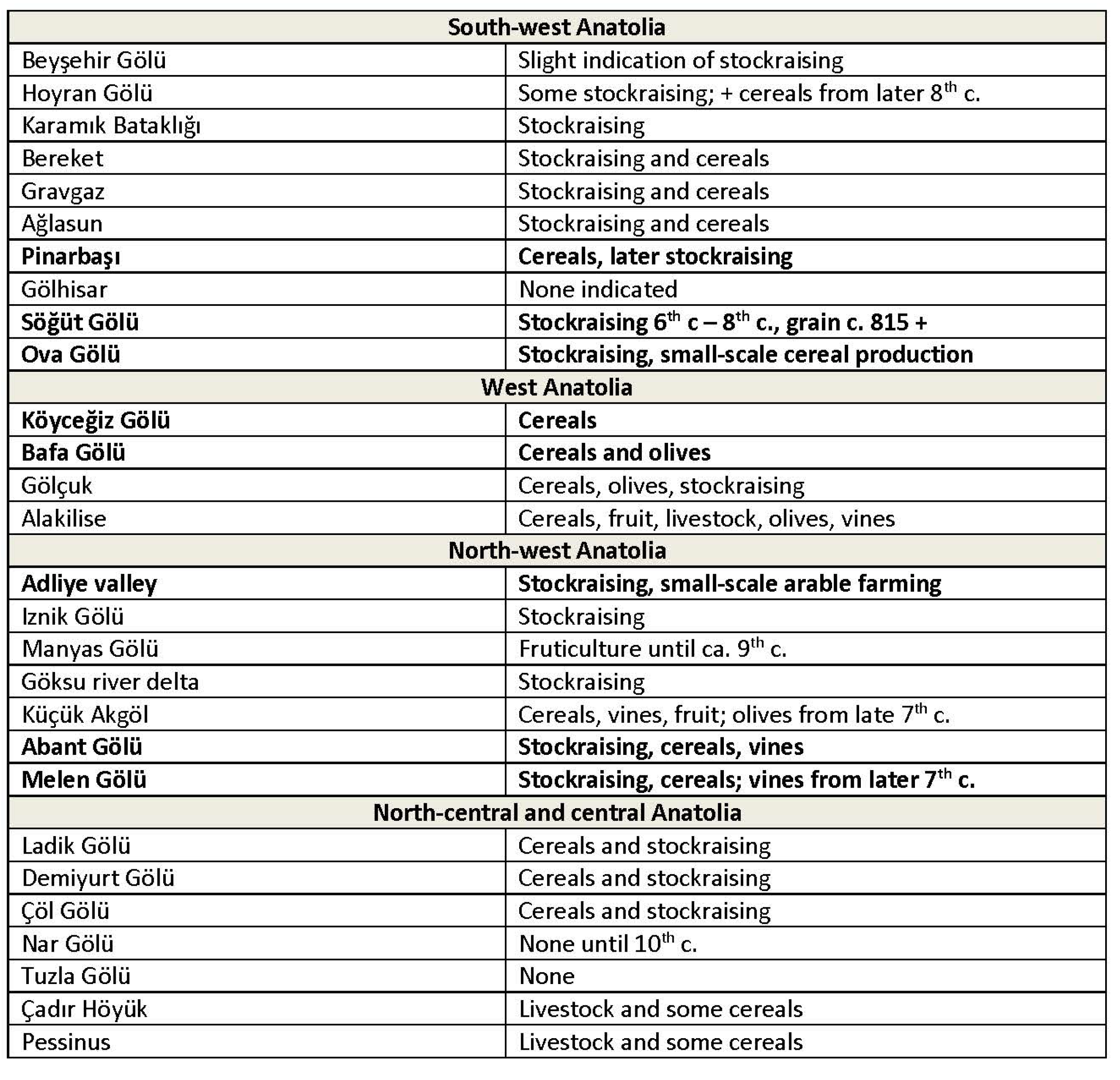
Figure 3].
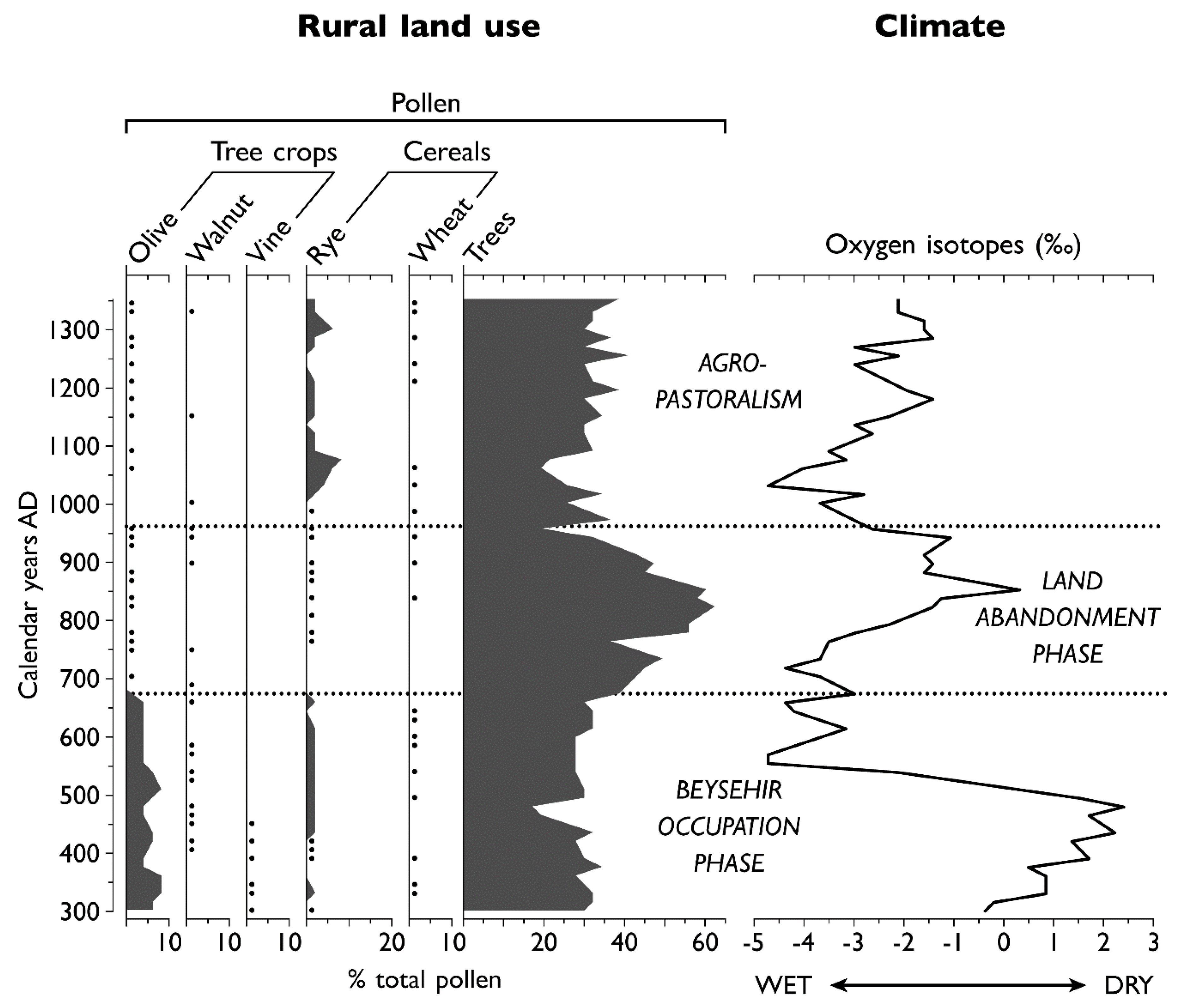
Thus, relatively well-dated stable-isotope records from (1) Sofular Cave (reflecting the southern Black Sea environment), and (2) Lake Nar, in Cappadocia (indicative of central Anatolia) concur in suggesting that in these regions the 4th-5th c. dry phase was followed by a rapid change to a much wetter climate from the late 5th century persisting into the 8th century [
Figure 4]. There followed a short-lived and somewhat drier phase in the 9th century, after which a period of greater humidity set in lasting well into the 14th century [
28,
29,
30]. A similar, though less precisely dated sequence for central Anatolia is indicated by the data from (3) Lake Tecer [
31]; whereas at two sites with more highly resolved chronologies (4) Lake Mogan (+/− 20 years), a little to the south of Ankara, the wetter phase begins over a century earlier [
32] and at (5) Lake Sülük (+/− 18 years), 2 km southeast of Boğaz Köy, likewise on the central plateau, the record indicates a relatively dry environment stretching through Late Antiquity well into the medieval period [
33].
In contrast, similarly well-dated speleothem data from (6) Uzuntarla cave in Thrace [
Figure 5], some 15 km from the Black Sea coast and to the northwest of Istanbul, indicate a relatively humid period lasting from the middle of the 4th century to ca. 690 CE followed by the onset of a short dry phase from ca. 690–740 and a subsequent wetter phase thereafter that lasted into the first half of the 11th century [
26]. The proxy data from (7) L. Yeniçağa (near Bolu, and located in the Pontic mountains some 250 km east of Istanbul) indicate fluctuations across the 6th and into the 7th centuries, with an arid phase lasting into the 540s followed by a wetter phase, returning to drier around the year 600, shifts that reflected both its particular geographical location as well as the varying impacts of the regional climate systems [
34]. Since Yeniçağa is situated at the point at which four of the above-mentioned climate regions intersect, it provides a good illustration of the variation between neighbouring zones, as indicated in the records from Sofular, L. Iznik, and L. Çubuk. Thus, the pattern indicated by the data from regional proxies at (8) Lake Iznik in northwestern Anatolia suggests a wetter climate up to the later 6th century, followed by a period of more arid conditions stretching from the early 7th into the 9th century [
35,
36].
By the same token the data from (9) Lake Çubuk (south of Bolu in northwest Anatolia and approximately 150 km by road east of Iznik) indicate a largely humid climate, with a drier period from the later 5th into the mid-6th century, becoming briefly wetter thereafter, and drier again in the 7th c. [
37]. Somewhat further to the east, palaeolimnological investigation at L. Çöl (10), on the relatively treeless plateau near Çankırı (Byz. Gangra), has generated some reasonably well-resolved chronology for premodern climate, and indicates a pattern of shifts from drier to wetter very similar to that for L. Nar [
38]. Finally, as an important indication of regional variation in southwestern Anatolia, the overall picture is significantly different: the Kocain Cave (11) record indicates that this region experienced the inverse pattern to that which prevailed in the central regions, sharing instead similarities with the Aegean, with a relatively humid climate regime in the period ca 330–ca 460 CE, followed by a shift to drier conditions lasting well into the 9th century [
19,
39] (
Figure 3).
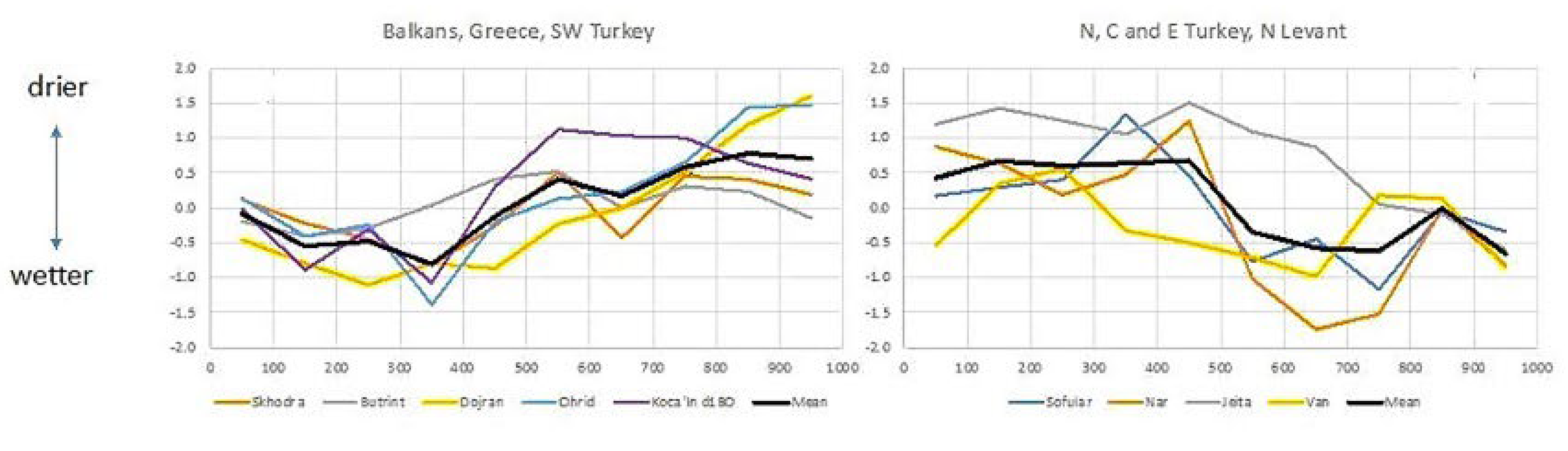
These data, therefore, indicate (i) a very highly nuanced hydro-climatic trajectory between the 4th and 14th centuries CE across much of Anatolia [
27]; (ii) a somewhat different trend indicated by the proxy climate data from the Balkans and Greece [
20], which as noted above extended into southwest Anatolia [
17,
19]; (iii) a general trend in the Balkans, Greece and southwestern Anatolia during the first millennium frequently to run counter to that which can be reconstructed for the rest of Anatolia and the northern Levant (see
Figure 6) [
17,
20,
21,
39,
40]; while (iv) southwest Anatolia was nevertheless generally wetter from the 9th century into the late 11th or early 12th century, which thereafter saw the onset of a period of relatively dry conditions [
41]. While similar variations between the southern and northern zones of the Levant are also apparent, the chronology remains insecure [
21,
23,
42,
43,
44]. This highly inflected picture is expressed very clearly in graphic form in [
33] (Figure 9).
There is one further complicating factor: the evidence from tree rings and speleothems from the Alps, central Europe, and the Altai mountains indicates a colder and drier climate during the middle decades of the 6th century. This is marked in particular by the onset of the LALIA from the late 530s, probably triggered by a major explosive volcanic eruption in the tropics which made the 540s the coldest decade within the so-called Dark Ages Cold Period (ca. 450–800) and indeed of the last two millennia [
5,
17,
23,
45,
46,
47]. Drops in summer temperatures of as much as 4 °C in the Altai data indicate the nature of the impact, certainly at higher elevations [
43] (pp. 145–149); [
48] (pp. 193–194). The exact impact of these conditions on lowland areas remains to be determined, and there is, for example, no obvious reflection of these developments in the Uzuntarla speleothem record [
26] (p. 13). But there are some indications in the pollen record from some archives, which register a decline in pollen taxa from some crops: for example, a decrease in agricultural activity is indicated in the pollen signatures for the regions around both Lake Iznik after ca. 540 and at Yeniçağa a little later [
34,
49]. As we shall see below, the pollen chronology from the latter is reasonably well-resolved, with a +/− range of just 15 years. This corresponds to some extent with the evidence from contemporary or near contemporary written records for a period of a few years, where significant disruption of the usual patterns of seasonal climate promoted poor or failed harvests, subsistence crises, and famine in several parts of the Empire and beyond. Yet, as Newfield [
5] (pp. 468–470) points out, the evidence currently suggests a short-term, regionally-inflected impact that did not necessarily have the dramatic consequences with which it has sometimes been associated. In the present state of our knowledge, therefore, we have some degree of correlation, but no clearly causal association.
In this context one issue that is rarely addressed—and which I cannot address here—is the important question of crop tolerances (see, for example, [
50,
51,
52]), an issue that has not been taken into account in most discussions of the changes during this period of medieval East Roman history. But in thinking about the possible range of impacts of greater or lesser shifts in seasonal temperature and precipitation, it is important to bear in mind the type of crop, landscape, precipitation data, and geology in thinking about landscape change in general. Broad generalizations about ‘cool’ or ‘cooler’ and ‘warm’, or ‘arid’, for example, are so subjective as to be useless unless carefully specified by context. Data about temperature and effective moisture, both key to the success of crops such as wheat, can tell us more about the potential for a shift in climatic conditions to damage output, depending on the region. There are plenty of examples across the Holocene of dry climatic conditions where the local population appears to have been relatively unafflicted, or even to have prospered. As Jacobson et al. [
19] (p. 19 of 31) remark, the Kocain data indicate that in SW Anatolia during the centuries of the Roman Climate Optimum, agriculture thrived in spite of relatively low effective moisture. For Late Antiquity, the shift to drier conditions occurred at least a century earlier than any significant changes in settlement numbers and investment, which can be broadly dated somewhere between 550 and 650 CE.
In summary, it is now possible to document more precisely the significant micro-climatic variations across the East Roman world, and more especially for the present context in Anatolia: between the Marmara transition region, the southwestern Black Sea region, northwestern Anatolia, central Anatolia and southwestern Anatolia, with asynchronic transitions between arid and humid, cold and wet occurring across the period from the 5th–6th centuries into the 10th and 11th (see, e.g.,
Figure 7). Not only this, but the fact of considerable intra-regional variation reflecting physical geographical factors all inhibit any attempt to generalize about climate conditions in respect of potential associations with socioeconomic and political developments. Spatial heterogeneity of climate in Anatolia as a whole is thus a very significant factor, and these regional variations are key factors that need to be integrated more carefully into the regional and sub-regional histories of both zones when considering their social and political historical evolution.
4. Land-Use and Agriculture: Data and Interpretive Challenges
How are these shifts in regional climate reflected in the palaeoenvironmental records? The first and most obvious point to underline is that differentiating between anthropogenic and climate-driven impacts is rarely straightforward and sometimes not possible. As has recently been underlined, there are instances where agricultural activity appears not to have been significantly impacted during a period of relative aridity, although seasonality of rainfall is very important, especially for wheat cultivation; a dry winter and/or spring (April–May are crucial months) can mean crop failure. By the same token, more humid conditions did not necessarily lead to greater productivity or intensification of agriculture. Such is very clearly the case during the period stretching from the 1st millennium BCE to the medieval period in southwestern Anatolia (the Roman provinces of Lycia and Pamphylia), for example [
19].
The major source for landscape evolution and land use is fossilized pollen, generally retrieved from cores sunk into lake beds or depressions in the landscape. Identifying the pollen in the cores is an immensely time-consuming and demanding process, but establishing chronologies and dating the material poses even greater challenges. If the layers of sediment can be dated, then comparisons can be made with archaeological and settlement survey data to assist in the investigation of the relationships between people and their landscape as well as of longer-term landscape dynamics [
53] (pp. 109–143).
But the accuracy of the chronologies is often problematic: i. Sequences may be based on a limited number of radiocarbon (
14C) ages, with interpolation between adjacent
14C ages, therefore assuming a constant sediment accumulation rate between dated horizons. ii. Sediment accumulation rates may vary, and this will affect the dating (and duration) of recorded phases. iii. The top of a core is often assumed to date to the present day, but this may or may not be valid, introducing further uncertainty in the age-depth model of the sequence. iv. Accelerator Mass Spectrometry (AMS) is a more accurate method of dating, several times better than standard or bulk
14C radiometric ages. But when calibrated to calendar ages, the resulting age range may still be unsuitable for direct comparison with historical and textual data sources at sub-centennial resolution, in turn rendering the elucidation of possible cause and effect relationships problematic and generating the so-called “suck-in and smear” effect [
54].
All this means that while pollen data can often provide a centennial-level date, it can only rarely offer a dating as resolved as decadal or better, so that making clear connections between landscape or agricultural changes and the often more accurately dateable societal changes is hazardous, although by no means impossible.
By way of illustration, Owen Doonan’s archaeological survey in the Sinop region has produced very good evidence for the growth and then the disappearance of a thriving late Roman olive cultivation. The archaeological evidence for the reduction or abandonment of the rural settlements associated with this agriculture currently offers no clear chronology, and dates between the late 6th and the 8th century have been suggested [
55,
56]. However, sediments from a recently (2015) extracted core from Lake Yeniçağa, in the Pontic mountains, have now been AMS dated, with the pollen sequence for the period 500–830 CE/1450–1120 cal BP having a mean chronological resolution of just 15 years [
34], thus comparatively precise. The lake is located at the natural limit above sea-level for olive cultivation in the Pontic region, lies some 300 km as the crow flies from Sinop, and is in the same climatic sub-zone. The pollen evidence points to a short period of olive cultivation in the immediate locality in the middle decades of the 6th c., as well as to other indicators for reduced demographic pressure on the local landscape, evidenced in the recovery of woodland and in indications for the evolution of an agropastoral economy. It also points to a decline in vine cultivation shortly after ca. 600, coinciding with the onset of somewhat more arid conditions. These new data and the more reliable chronology make a significant contribution insofar as they strengthen the likelihood of a later 6th c. date for the rapid breakdown of the olive agriculture of the wider region and especially the Sinop peninsula. But it cannot help with the reasons for the change.
The Yeniçağa evidence also indicates a short-lived period of wheat cultivation in the 580s to early 7th c., corresponding with a decline in vine pollen percentages; then in the 670s emphasis on the more resistant crops of barley and rye, although this fades away by the early 8th c. From the middle of the 8th c there seems to be a more permanent recovery in agriculture, initially barley and rye, but with some wheat and oats, combined with grazing weeds indicative of livestock, and then gradually superseded by tree crops, walnut, hazel, chestnut, olive, and vine, especially from the last decade of the 8th c. [
34]. Yet again, the precise role played by shifts in the climatic conditions and the range of possible anthropogenic factors remains unclear.
Pollen and palaeoclimate data from L. Iznik, close to Istanbul/Constantinople and within the so-called MTZ or Marmara Transition Zone, paint a similar picture [
49]. Here, the onset of a slightly more arid climate can be dated ca. 580–600 CE, intensifying from 660 and lasting into the second half of the 8th c. This is paralleled by a decline in olive pollen as well as in other crops, including cereals. But here the temporal variation is at least 57 years, so the resolution is not precise enough to suggest a clear moment between the mid-6th and later 7th c for the changes in question. If we prefer a mid-7th c date for the decline of oleoculture in this locality, we could perhaps attribute the decline to anthropogenic causes, including intensive Arab attacks in the 660s, 690s and leading up to the siege of CP in 717–18, as documented by Marek Jankowiak [
57], for example. An earlier association might suggest the longer-term demographic impact of the Justinianic plague [
5] (pp. 471–473), or a shift in local market demand and/or commercial networks, or perhaps a combination of many factors, including both cooler climate, shifts in market demand, and disease. This combination of factors would certainly fit the date range for the changes indicated by the Yeniçağa pollen.
Where correlations can be clearly pinpointed between chronologies for climate change and landscape evolution, or between the latter and events such as outbreaks of disease, the impact of warfare, or changes in the pattern of ceramic distribution associated with trade and commerce, one might plausibly argue that there are likely causal associations, even if weak ones; climate or disease as an exacerbating or intensifying factor, for example, if not as a major cause. Whether or not it is possible to build a persuasive argument along such lines at all depends upon the quality of all the different categories of data: palaeoecological, archaeological, and historical.
5. Land-Use and Agriculture: Central Anatolia 6th–11th c. CE
In what follows, I will focus chiefly on central Anatolia. The social and economic history of the period up to the middle of the 7th c. has been reconstructed in some detail from both written sources of many different kinds, as well as from archaeological and palaeoenvironmental evidence. But from the mid-7th c. to the middle of the 10th c., it has been the ever-expanding corpus of archaeological evidence for settlement, material culture, and economic life, including commerce and urban-rural relationships, that has been crucial in advancing our understanding of the period.
These well-established sources of evidence have for the last decade or two been increasingly complemented by palaeoecological and palaeoclimatic data. This has provided both context and depth to our knowledge, but it has also made it possible for the first time to answer questions about the landscapes that formed the backdrop to all these changes. The results of localised surface survey work in different parts of Anatolia, combined with the data from palaeoecological as well as palaeoclimatic research, alongside whatever historical evidence we may have, now provide enough material to speak about local developments with some degree of confidence. As was pointed out more than 10 years ago, and as has since been reinforced by others, the one thing we can say for sure is that the changes of the 6th–9th c. produced a far less homogeneous landscape, both within climatic and environmental sub-zones as well as between them [
53] (pp. 217–225). The most important of these changes include the dramatic contraction of most larger and mid-sized urban centers, either to a fortified core and/or to a core with associated semi-urban suburbs or islands of occupation, but with significant differences between coastal and inland settlements, the abandonment of some urban centers and/or the migration of their inhabitants to more secure locations [
58,
59,
60], [
61] (pp. 81–141), and a thinning out of rural settlement, again with regional emphases, with a likely (but barely yet investigated) changing relationship in some areas between field, pasture and settlement [
62,
63,
64,
65,
66,
67,
68]. As far as we can say at present, the only exception in central Anatolia to the first of these transformations, Amorium, remains just that, explicable in terms of its particular geostrategic significance across the 7th, 8th and first half of the 9th century, and thus comparable to some of the coastal port cities that can now be seen to demonstrate more continuity than used to be thought [
69,
70,
71]. As we have seen in
Section 3, there is little indication in the palaeoclimate data of significant shifts on the central plateau region between the 7th and 10th c., although a trend towards greater aridity from the mid-8th into the late 9th and early 10th c. will certainly have impacted agriculture in marginal and upland zones. But the social-economic and cultural changes outlined above must have had a significant impact on rural hinterlands and land use patterns.
Until recently detailed information on how such shifts may have impacted land use was based entirely on a few indirect references from historical sources (such as, e.g., the so-called ‘Farmers’ Law’ of 8th or 9th c.), and on what evidence for agricultural production could be retrieved through archaeological excavation and survey. With a particular emphasis on zooarchaeological and palaeobotanical evidence, the archaeological data for the evolution of the Anatolian landscape has recently been very comprehensively summarized by Marston and Castellano [
72,
73], to whose results we can add new data from ongoing work (e.g., the faunal evidence from the important rural site at Çadır Höyük [
55]). But the availability of increasing amounts of proxy land-use data provided by fossil pollen analysis permits, for the first time, a more detailed account of the full scope and character of the changes that took place.
While several pollen cores from sites across the region need re-appraisal and chronological refinement (see
Section 4 above), there exists enough relatively well-resolved evidence to corroborate and to add nuance to or to modify the conclusions drawn from the archaeological evidence [
53] (pp. 194–201); [
54] (pp. 285–295). Although the latter and the palynological evidence do not map entirely consistently onto one another, they nevertheless tell very similar stories. It is clear that there was relative continuity of crop regimes in areas least affected by warfare and economic disruption, and shifts to a different pattern in areas subject to various forms of disruption. There was a fairly generalized decline in arboriculture everywhere, although more pronounced in some areas than others [
72] (
Figure 8). In those regions on the plateau and its margins where olive and vine had been cultivated, these largely disappeared or declined to such an extent that they have left no signature in the pollen record. In the Mediterranean and Aegean coastal plains and river valleys, the classic late ancient agrarian tradition, characterized by a mixed regime of vine, cereal, and olive production, retreated to a much less intensive level. The traditional patterns were gradually replaced, at different rates according to area, either by a more limited range of crops or in some cases by natural vegetation and woodland regrowth [
27] (Table 2); [
19,
34], [
74] (Figure 5), [
3] (pp. 145–215), [
75] (pp. 277–278).
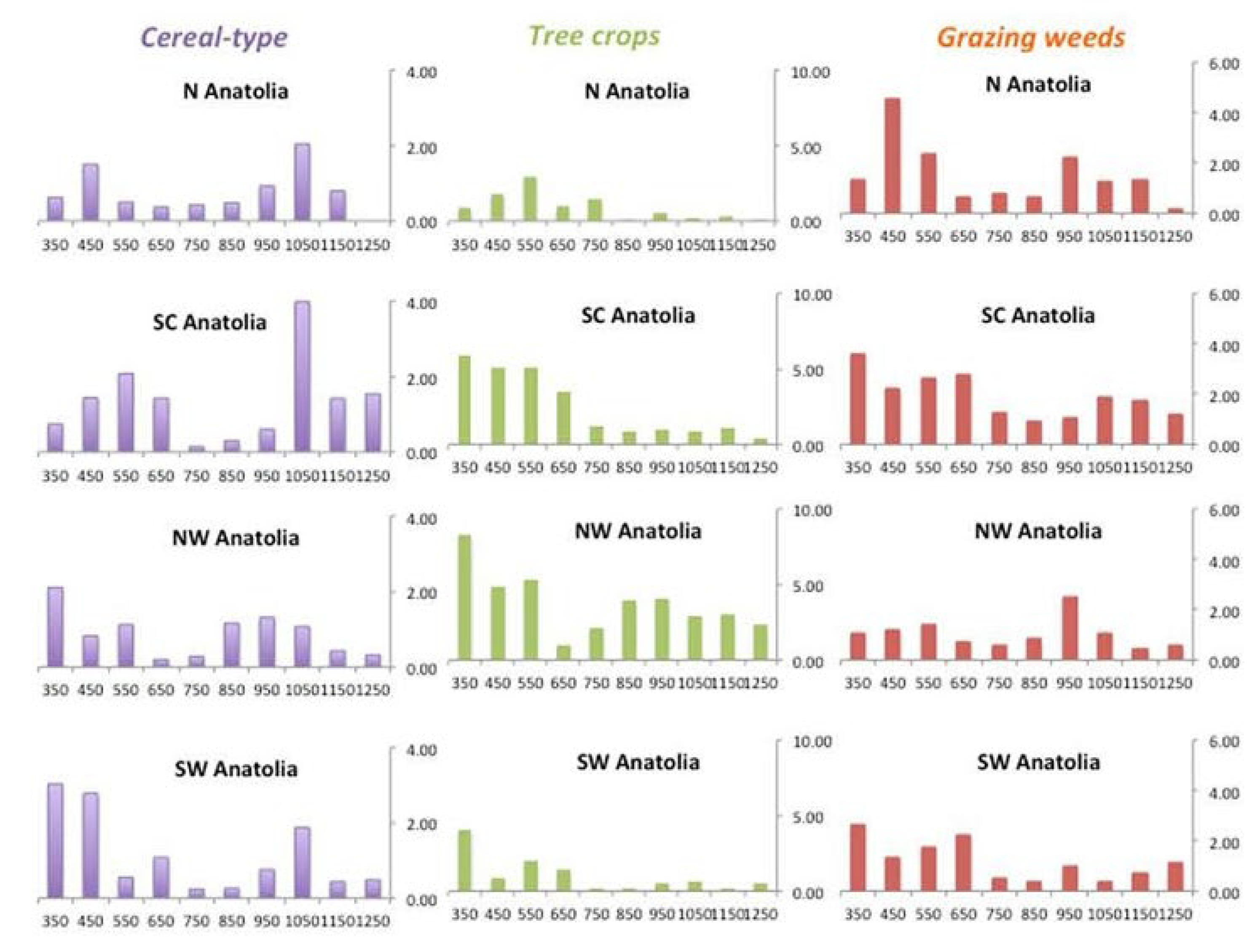
But the pollen data can now add some important new detail to this picture. The central plateau and upland regions, more generally, had traditionally been dominated by cereal agriculture and pastoralism. This did not change dramatically, except in intensity; pollen percentages drop sharply in the course of the 7th century (
Figure 8). But in spite of this dramatic decline in the levels of agricultural production [
30] (
Figure 3), the pollen record also indicates an increased emphasis on livestock and cereals relative to other crops.
The data reveal that it was not simply a question of reduction of output, or of retrenchment, or of abandonment. To the contrary, the record suggests a positive move towards a different balance in agricultural production, a process that, again, does not coincide with any significant climate shifts. This is not to deny that local and micro-regional patterns may in some cases have run counter to a broader prevailing trend [
62] (pp. 264–2670; [
75] (pp. 276–278), nor indeed that the changes were all the result of the same factors at the same time. For example, changes in the pollen records at some sites in southwest Anatolia are evident already for the 5th c., suggesting local pressures on agriculture about which we still know little or nothing [
19,
75], [
62] (p. 270), [
76] (pp. 44–47, 177–192, 233–238). Yet in spite of the chronological uncertainties associated with some of the pollen data, the 7th c. appears to be the period during which the pace of such a rebalancing substantially intensified.
An important aspect of this is that the changing pattern is not uniform: the sites at which these shifts in pollen composition are observed do not necessarily represent more than their own immediate hinterland. Sites indicating change are located in the same region as sites with continuity (
Figure 9). The conclusion must be that this pattern reflected the choices, needs, and priorities of rural communities, local exchange networks, and perhaps other pressures, rather than any universal forcing pressure. I will discuss some possible answers to this question below.
As the East Roman state reestablished political and military hegemony in S. Anatolia and N. Syria in the decades from ca. 850–1000, the process of social and economic recovery can be seen in the archaeological record, in the gradual recovery of new forms of urban life from the later 9th century in Anatolia and a little later in the S. Balkans, in the expansion of rural economies as indicated in site and regional surveys, and in the numismatic and ceramic data indicative of increasing commercial and exchange activity [
77,
78], [
79] (pp. 43–89), [
76] (pp. 145–158), [
40] (pp. 233–236). On the basis of the palynological record, agricultural expansion in the southwest of Anatolia had already begun by the middle of the 9th century and at about the same time along the narrow southern Black Sea coastal plain. By the middle of the 10th century an expansion of cereal cultivation was under way in other regions of the Empire, such as central Greece and eastern Bulgaria, although considerably later, ca. 1100, in more northerly districts such as western Macedonia [
62] (pp. 267–268), [
80] (pp. 412–420); [
41] (pp. 235–236).
To summarise: The changes that took place during the 7th–9th c. are generally interpreted as a shift towards agro-pastoralism, a view now corroborated by the palynological evidence. This was a pattern that appears to have dominated central Anatolia from the 8th century. Based in some districts on extensive ranch-like estates, it has also been linked to the rising political and economic power of the Anatolian magnates [
81] (pp. 100–101), [
82] (pp. 44–58). By the 9th–10th c., this had expanded into new areas, while with the return of political and economic security, lowland areas of northern, western, and southwestern Anatolia returned to the cultivation of commercial crops such as olive trees. But the precise trajectories and forms of recovery as reflected in both palynological and archaeological evidence varied between different regions. Evidence for agro-pastoralism in western and southwestern Anatolia, for example, has been interpreted in part as an indication of dairy farming, and reflected the growth of new markets and a wider commercial exchange network across the E. Mediterranean basin and the Aegean [
19,
75], [
76] (pp. 192–232), [
30] (pp. 312–315). A somewhat wetter climate regime, as indicated by the proxy data for central and northern Anatolia from the middle of the 6th century into the 8th century [
22], [
41] (pp. 232–233 and Table 2), would have been favorable for cereal cultivation (which requires extended winter precipitation) as well as stock-raising. But as we have seen, no change in the general trajectory of the pollen signature for cereals can be observed until the middle and later 7th century, long after the climatic shift had taken place. The same applies to some of the declining signatures for vine and olive cultivation. The reasons for many of these changes in emphasis in land-use and the pattern of agricultural production cannot, in consequence, be linked to changes in climate. As far as the current state of our data permits us to say, therefore, there was never a period during which all regions of Anatolia, still less of the E Roman Empire as a whole, would have been placed at the same time under the same degree of climate stress resulting in the same consequences [
5,
19,
30,
39,
72].
A final point, although I will not pursue it here, concerns the extent to which agrarian communities planned for “normal” challenges, such as poor harvests. This can be deduced to some extent from both the archaeological and palaeoecological data, where available, which serve as a record of societal responses to a range of pressures on land-use [
83,
84,
85,
86,
87]. But we should bear in mind that agrarian populations did not always or necessarily take advantage of such shifts. While agricultural communities can be flexible and responsive to change, path dependencies—both cultural and practical—can inhibit societal responses to change. Modern surveys among traditional farming and pastoralist communities have shown that perceptions of changing seasonal climate vary according to cultural tradition, location, and a host of other factors, and can be very low even in societies with a higher degree of literacy than that typical of most pre-industrial cultures [
88]. Such factors also need to be borne in mind when thinking about the reasons for shifts in patterns of land-use change in the Byzantine world.
6. Adaptive Strategies: Social, Fiscal, and Administrative
The acceleration in the shift in the patterns of agriculture in 7th-century Anatolia seems to have been relatively dramatic, especially for olive and vine cultivation [
62] (pp. 264–267), [
54] (pp. 301–302), [
27] (pp. 146–147), [
76] (pp. 44–47, 177–192, 233–238). The possible reasons for this and the particular factors that might have led to farmers changing what they produced at this particular point in time still require clarification. Here we must integrate all the sources, including the historical evidence, in particular that from the numerous lead seals of imperial officials, and legal and official or semi-official documents. More problematic sources—in respect of authorship, textual tradition, and personal political or ideological bias—are the anecdotal evidence of hagiography and the limited contemporary chronicle literature. All of these together provide some crucial information about society and state administration. Given the absence of any coincidence between climate changes and changes in agriculture, and assuming we can exclude, at this period, shifts in dietary habits, three possibilities for the changes in question remain: shifting market demand, warfare and insecurity, and pressure from a third party, such as a landlord, or the state.
In respect of the first of these types of pressure, the archaeological evidence is quite clear: across the course of the 7th century, international and regional markets shrank or changed, and local markets redirected their focus, so demand for a wide range of products must have been affected. At the same time, inland regions in particular became more than ever reliant on locally-produced resources [
89,
90,
91]. So we cannot exclude market pressures as one possible reason for changing patterns of agricultural production. In respect of the impacts of insecurity and economic disruption, while many regions were negatively impacted by warfare well into the eighth century, the archaeological picture has been substantially complemented by new pollen evidence. For example, the chronologically highly resolved pollen evidence from Nar Lake in Cappadocia coincides with historical information to show that a period of continuous raiding and enemy occupation between 664 and 678 led to a near-complete collapse of agriculture in the area. Such a dramatic impact may not have been very common, but that it could occur is made clear by this example [
62] (pp. 262–267), [
92]. Archaeological survey data suggests that rural populations adopted economic strategies—including greater reliance on pastoralism, for example—that permitted a rapid evasive response to attack, a response reflected in the archaeological evidence for a thinning out of rural settlement in many regions, the fortification of small urban centers, and the re-use of upland refugia [
89] (pp. 538–542, 551–559, 564–570).
As regards the third type of pressure that might impact agriculture, that brought to bear by a third party, we should consider the fiscal and related demands of the East Roman state. This had to negotiate an unprecedented crisis in resources as well as in respect of its military situation [
30] (pp. 308–312), [
10] (p. 230, Table 6.2). By the 640s and following the loss of the eastern provinces and much of the Balkans (losing something in the order of two-thirds of its territory and three-quarters of its fiscal revenues in the years between 634 and 642), the imperial armies had been withdrawn from their original bases and garrisoned across territories in Anatolia that could provide for their needs. Here, it is notable that the smallest of these field armies, referred to as the
Armeniakon, occupied an extensive region of eastern Anatolia, but one that was economically among the least productive. This contrasts very clearly with the more fertile districts to the west and southwest, where much larger forces were based.
In addition, we can point to some interesting changes in technical language to do with the tax system, indicating a realignment of key aspects of the state’s fiscal administration, in particular in connection with the supply and management of grain. These shifts took place in the last 30–40 years or so of the 7th century. While the changes cannot be firmly assigned to a particular decade, the written evidence suggests the 660–680s as the most likely period [
10] (pp. 258–282).
The fiscal arrangements are significant because they connect directly with the question of military supply. Here, the importance of grain cannot be understated [
93]. After 642, the government lost access to the massive grain supplies delivered annually from Egypt, now under Islamic control, a substantial loss affecting both the government’s ability to feed the population of the capital, Constantinople, as well as to supply some of its armies, especially in the Balkans. Locating new supplies of grain for the capital was a problem, but one that was resolved to an extent through the Empire’s maritime resources as well as from local supplies.
More challenging was the fact that the field armies, newly relocated to the Anatolian provinces, needed to be provisioned, thus imposing a substantial new demand for grain on the areas where they were based. Conditions for cereal production are readily found in many districts of Anatolia, but the increased annual precipitation that affected much of the region from the 6th century also affected areas hitherto less well-watered and will have made the introduction or expansion of cereal cultivation both easier and more profitable [
10].
It seems a reasonable working hypothesis, therefore, that together the different strands of evidence reflect in part the outcome of a state-directed adaptive strategic shift in resource production in response to the crisis it was facing. The administrative changes noted above, in association with the increased emphasis on grain production and livestock, and the changing pattern of agricultural production reflected in the pollen record, certainly coincide chronologically. This certainly makes sense in terms of generating the resources the government needed to feed and field its armies and thus to secure the continued existence of the state and its infrastructure: grain and livestock. How the policy was enacted will likely never be known; whether farmers or landowners in the regions where military units were based took advantage of the increased demand for grain, or whether the state manipulated the fiscal burden to facilitate grain production, is not known. The focus on cereal and livestock recurs in the (admittedly still very sparse) archaeological data (e.g., [
73], p. 338–346) [
75]. But similar shifts in imperial fiscal policy had occurred earlier, for example in 5th-century Italy. Here, both imperial legislation and the archaeology of the south Italian countryside, in particular with regard to the construction of granaries, attest to this policy [
94] (pp. 265–270), [
95] (pp. 224–27, 232). Viewed as a complex adaptive socio-ecological system, the East Roman state was able to adapt its management of manpower, material resources, and the redistribution of fiscal income in responding to the pressures and stresses it had to confront, and both the archaeological as well as the palaeoecological evidence hint as to how this was achieved.
7. Case Studies
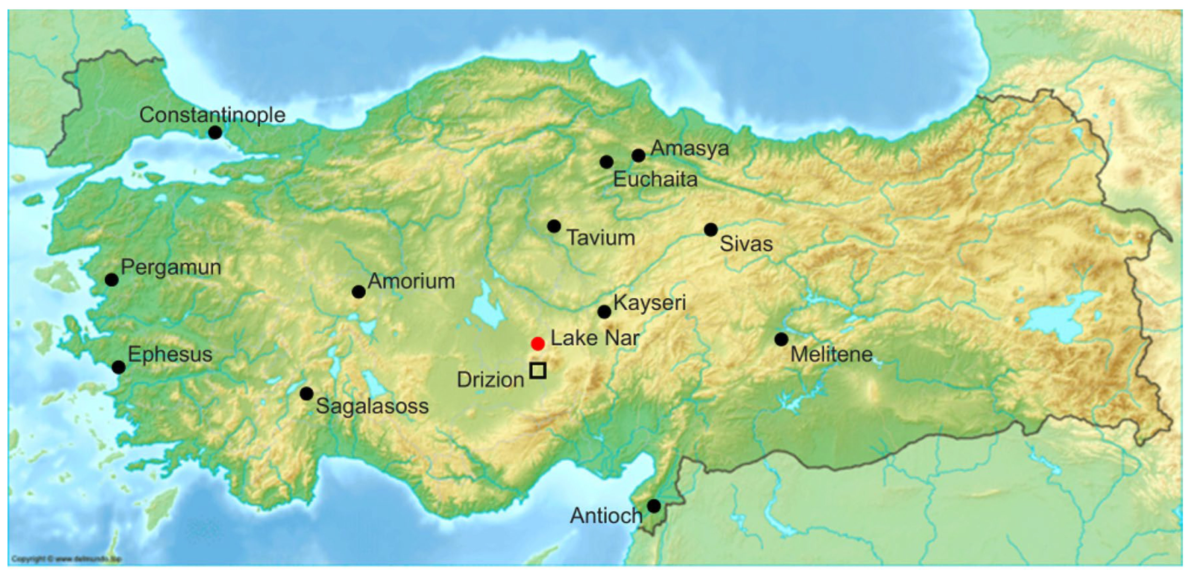
One possible historical and archaeological indicator of this complex combination of developments may be illustrated by the fortunes of the small semi-rural semi-urban settlement of Euchaïta in the Pontus, located on the northern edge of the Anatolian plateau (
Figure 10) and in a historically well-documented grain-producing district, with a major center at Amaseia (mod. Amasya). Today a small village (Avkat/Beyözü), its climate regime is typical of its situation between the Anatolian plateau to the south and the north Anatolian (Pontic) mountains to the north: semi-arid, with annual precipitation today between 400 and 440 mm, peaking in late spring (May), severe winters and hot, dry summers. Drought, and consequent reduced agricultural output, is not uncommon [
54] (p. 283); [
96]. The closest source of palaeoenvironmental data is at L. Çöl, a little to the east of Çankırı and some 140 km in a direct line to Avkat/Beyözü. Both share a similar situation in terms of soils and climate, although the sheltered valley in which Euchaita is located (at some 800 masl) is less barren than the plateau on which L. Çöl is located (1028 masl). During the Roman period the site of Euchaïta seems to have been little more than an obscure farmstead or hamlet, but from the 4th century, when it is first mentioned in the sources, it began to gain a reputation as the center of the cult of St Theodore
Tiro (“the Recruit”) [
97]. It was walled in the early 6th century and raised to the status of a bishopric by the Roman emperor Anastasius, before 518. From the 7th century, with the Arab Islamic conquest of the eastern Roman provinces, and the retreat of the Roman, now Byzantine, frontier into Anatolia, Euchaïta became a military base behind the frontier. Archaeological survey indicated substantial evidence of late Roman/early Byzantine occupation and building, in both the area of the lower town, now covered by the modern village of Avkat/Beyözü, as well as on the fortified hill behind the settlement. It remained a provincial center until its conquest at the time of the Seljuk occupation of eastern Asia Minor, in the late 11th century. Thereafter, its importance dwindled, and throughout the period of the Ottoman Empire and until today, it has remained a small village below the hill on which are located the ruins of its fortress [
98].
The ceramic material from the survey covers all periods from the Chalcolithic to the Late Ottoman, but with a predominance of Late Roman and Early-Middle Byzantine. The overall pattern in the survey material was of a relatively high density of Early Byzantine material (i.e., 7th–9th century) compared with that from the Middle Byzantine period (9th–12th c.). Just as significantly, it was calculated on the basis of the extensive survey of the area around the settlement itself that the land-use footprint of the Late Roman period differed from that of the subsequent Early Byzantine (7th–9th c.) period. Over 60% of the area identified as Early Byzantine outside the putative line of the city walls was located in spaces not exploited in the preceding period. Analysis and modelling of these survey data indicated a land-use pattern pointing to a relatively high level of persistence that entailed also expansion and changes in modes of landscape exploitation [
99]. The evidence from the archaeological surveys of Paphlagonia and the region around Gangra/Çankırı or around the city of Sagalassos may offer parallels, with a thinning out of rural settlement, and a likely (but barely yet investigated) changing relationship in some areas between field, pasture, and settlement [
62,
63], [
100] (pp. 193–199); [
101]; [
58] (p. 278); [
64,
68].
Euchaïta lay at the heart of an extensive cereal-growing district in the territory allocated to one of the major field armies of the Empire, the
Armeniakon. There is neither fossilized pollen nor palaeoclimatological data from the immediate vicinity of the settlement, but that from L. Çöl and L. Nar share a similar profile in indicating wetter conditions throughout the 7th c., while the pollen record from Çöl shows a landscape dominated by small-scale cereal production and grazing. But it is not an especially fertile landscape, and it is remarkable that in some more fertile areas a steeper decline in cereal pollen can be observed in the 6th–8th c. than the relatively slight decline indicated by the Çöl data. This might support the suggestion that this north Anatolian plateau region retained its value for cereal farming even on a very small scale. The value of the wider region around Euchaïta would have been proportionately much greater. A similar situation may be reflected in the survey data from the rural hinterland of the ancient coastal settlement of Aegialos (modern Cide), which appears to have retained a degree of agricultural importance and continuity of rural activity through the 7th and 8th centuries [
101] (pp. 388–389).
The analysis of the survey data from the environs of Euchaïta would tend to corroborate the development of an increased strategic and economic role for the settlement in the 7th–9th c. The continuing and indeed expanded presence of material dateable to the later 7th century and beyond, and the appearance of what appear to have been new functional sites—possibly workshops or steadings—in the hinterland of the urban settlement, are suggestive. It suggests that the latter achieved a raised profile as a center of activity at a time when grain was in high demand [
102], [
54] (pp. 298–299). This is in stark contrast to many comparable small or middling fortified urban settlements of the period across the East Roman world in this period [
68,
78,
101,
103].
The history of Euchaïta, insofar as we can reconstruct it from the evidence currently available, may be an example of one of the ways in which the longer-term change in climate could entirely fortuitously have benefited the East Roman Empire at a crucial period in its history by permitting a continuity, and possibly a relative increase, in grain production and agro-pastoral farming that responded to the immediate demands of the state in its struggle for survival. The extent to which landowners and peasant farmers took advantage of the needs of the government to supply its armies, or were simply responding to pressure imposed from above, remains unknown. The policy shifts promoted by the imperial administration could not reflect any conscious awareness of the shifting climatic trends that affected parts of Anatolia. But in any case, the small city of Euchaïta reaped the benefit for some two centuries before dropping back into relative obscurity.
Developments in the middle decades of the 10th century offer a second example. As noted briefly in the introductory sections of this article, from the middle of the 9th c., the Empire was able to go onto the offensive on a large scale in both the Balkans and along its southern and eastern frontiers [
104]. The archaeological evidence for settlement expansion, the recovery of urban economies, and the re-establishment of imperial control over formerly frontier zones is well documented and continues to expand. This transformation is also evident in the paleoenvironmental evidence, and one site in particular offers particularly clear evidence for the impact of these changes.
The pollen data from Lake Nar in Cappadocia, as mentioned above, indicate a radical and dramatic retrenchment of human agrarian activities in the period 664–678, consistent with the effects of a decade of hostile raiding and occupation in the 660s-670s. The same data, however, also indicate a significant and very obvious recovery some 280 years later, around 950. But we see a very different configuration of the human economy of the region. The emphasis now is on cereal production and pastoral farming or ranching, in contrast to the much greater extent of orchard- and garden-crops of the earlier period before their abrupt termination. The recovery of agriculture and stock-raising suggested by the pollen evidence indirectly indicates both demographic and economic expansion. This is reinforced by the archaeology of the region, which attests to a significant recovery in settlement and of investment in the built environment, most notably but by no means only in ecclesiastical and monastic buildings (e.g., [
105,
106]) (and see below).
Just as significantly, however, the palaeoclimatological data from the lake-bed sediments at L. Nar also point to a significant improvement in the climate of the region, with the end of a relatively dry period and the beginnings of a century or more of wetter climatic conditions [
28,
92]. This shift in conditions is supported by a range of other palaeoenvironmental and historical evidence, not only from Cappadocia, but from other regions of Anatolia [
41] (pp. 229–252).
A good indication of the change is offered by the case of the fertile imperial
episkepsis (estate) of Drizion, with its fortress [
107] (pp. 172–173), located not far to the south of Lake Nar (
Figure 11), identified archeologically with the remains of ruins of both secular and ecclesiastical structures near Kınıkören, south of Antigus, mod. Altunhisar. Located on the road from Tyana northwards, it was in Roman times a station or hostelry of the imperial post. The emperor Nikephoros II passed through the locality with his troops on a campaign into Arab territory in 965, and a few years later, the estate was temporarily usurped by a senior palace official, Basil, before being restored to imperial control by the emperor John I in 975. The written sources suggest that Drizion was a wealthy estate and had only recently been restored to imperial control and made safe from hostile attacks after years of warfare and conflict. It may well be the activities of imperial estate managers, in expanding or re-establishing cereal production as well as other crops, which the pollen data from Lake Nar for the period from 950 onwards reflect [
28,
92].
The remarkable economic recovery that took place in Cappadocia and throughout central Anatolia from the middle of the 10th century onwards is reflected in new church building or restoration, in the settlement archaeological evidence, as well as in the written record of the period (contributions in [
103], [
105] (pp. 2–4, 201–205), [
106] (pp. 432, 438–453). This also reflects the investment strategies of some of the great Anatolian aristocratic landlords of the 10th century and afterwards who figure very prominently in this period in Byzantine society and politics [
108], [
109] (pp. 448–449), [
76] (p. 197). While it can to some extent be attributed to imperial military successes coupled with the dynamism of the aristocratic elite that spearheaded the process, there should be no reason to doubt that the relatively favorable climate conditions that set in during the middle decades of the century must have been a further stimulus to the process of economic recovery and expansion across the region.
While the Nar data indicate a significant change in terms of cereal production, however, the shift in climate encouraged a whole range of changes in regional agriculture beyond the immediate catchment of L. Nar, including the production of wine on a large scale. The impressive wine-producing establishment and farmstead attested archaeologically at Mavrucandere, not far from Drizion, which can be dated from the middle of the 10th c. into the later 11th c., is just one of several now identified in the region, possibly to be associated with elite investment for local and regional markets (including the military) [
41,
110] (for broader context see [
79] (pp. 54, 63–90). While the recovery in imperial fortunes at this time begins before any changes in climatic conditions become apparent, it seems reasonable to suppose that climate was likely an additional stimulus and certainly beneficial to an already existing process of change.
When placed in the longer-term context of social, economic, and political developments, therefore, the archaeological evidence reflects the outcomes of the complex human adaptive responses to such developments. In this instance, the point is underlined by the fact that the pollen evidence in the Nar data indicates a sudden downturn in regional economic activity and the abandonment of cereal production on a substantial scale around ca. 1100 CE (
Figure 12). Yet there is no indication of any contemporaneous shift in climatic conditions. This change, and the subsequent recovery about a century later, can surely be associated with the occupation of this area by the Selcuks, firstly, and secondly, the economic and agricultural recovery of the region as political and economic stability were restored at the beginning of the 13th century [
28,
92,
111].
8. Concluding Remarks
The “archaeology of climate change” thus presents many challenges in light of the current situation with regard to the archaeology of the Byzantine world in general. Firstly, we are faced with a continuously evolving interpretative situation as a consequence of our ever-expanding archaeological data. Secondly, obtaining sufficiently resolved chronologies for the proxy data, and in particular for the palynological evidence, remains challenging. In consequence, and thirdly, identifying a causal link between the material–cultural evidence for the evolution of settlement, settlement distribution and type, and demography, on the one hand, and on the other the information derived from the palaeoclimatic and palaeoenvironmental data, necessarily involves placing emphasis on degrees of correlation, and as we know, “correlation is not enough” [
112,
113]. At the same time, the archaeological data for landscape change and land-use associated with settlements remains extremely sparse for Anatolia, so that it is more than challenging to relate the latter to climate change, still less to the impacts of seasonal variations.
It is generally agreed that the transformation of the established “classical” pattern of urban life from the 4th century onward—a complex, multi-stranded process across all regions of the Roman Empire—was dramatically sped up by events of the 7th century. This is most obvious in the archaeological evidence for the fragmentation of long-established patterns of commerce and exchange and for the impacts of the Arab-Islamic invasions in the Near and Middle East. Historical and archaeological sources document changes in the composition of the elite, loss of imperial revenues on a massive scale, recurrent plague, and demographic decline (see now the contributions to [
114]). The proxy data, even taking into account the imprecision of some of the chronologies, suggest that the economic changes took place after the beginning of the 7th century rather than being coincident with the coolest period within the LALIA, the 540s and 550s [
5,
41]. They also indicate that such changes were micro-regionally highly nuanced and likely took place over decades [
101] (pp. 385–388).
The changes in land-use, agriculture and settlement noted above that are reflected in both the palaeoecological and archaeological records for the most part do not coincide with any significant shifts in climatic conditions, except possibly for the impact on olive cultivation of the somewhat lower average seasonal temperatures indicated for the LALIA, from ca. 537 to the second half of the 7th century. This being said, however, I have argued above that one of the “invisible” longer-term outcomes of a wetter climate was the potential for an increase in cereal production relative to other crops and in the context of a considerably reduced producing population. The stimulus for change may have been pressure from the state alone, or a combination of this, together with shifts in patterns of consumption and thus in market demand. In either case the evidence is consistent with this potential only being realised as a result of a complex combination of the fragmentation of the established patterns of exchange with state fiscal policy in the second half of the 7th century; while in the 10th century the shift towards a more beneficial climate regime undoubtedly assisted the expansion of the Empire’s agrarian economy as it coincided with its political and military recovery. We can argue plausibly that climate played an important role. But we should be clear that, in these examples at least, this was by no means a simple cause-and-effect relationship, a point that applies as much to that between settlement demography and climate as it does to that between climate and disease [
4,
5,
115].

