


Petrographic and Size Analysis of Lithic Artifacts of Loreto (Early Middle Pleistocene, Basilicata, Italy) to Support Insight on the Site Lithic Industry and Human Behavior

 ,
,  , and
, and 
Abstract
1. Introduction
1.1. The Paleolithic Site of Loreto
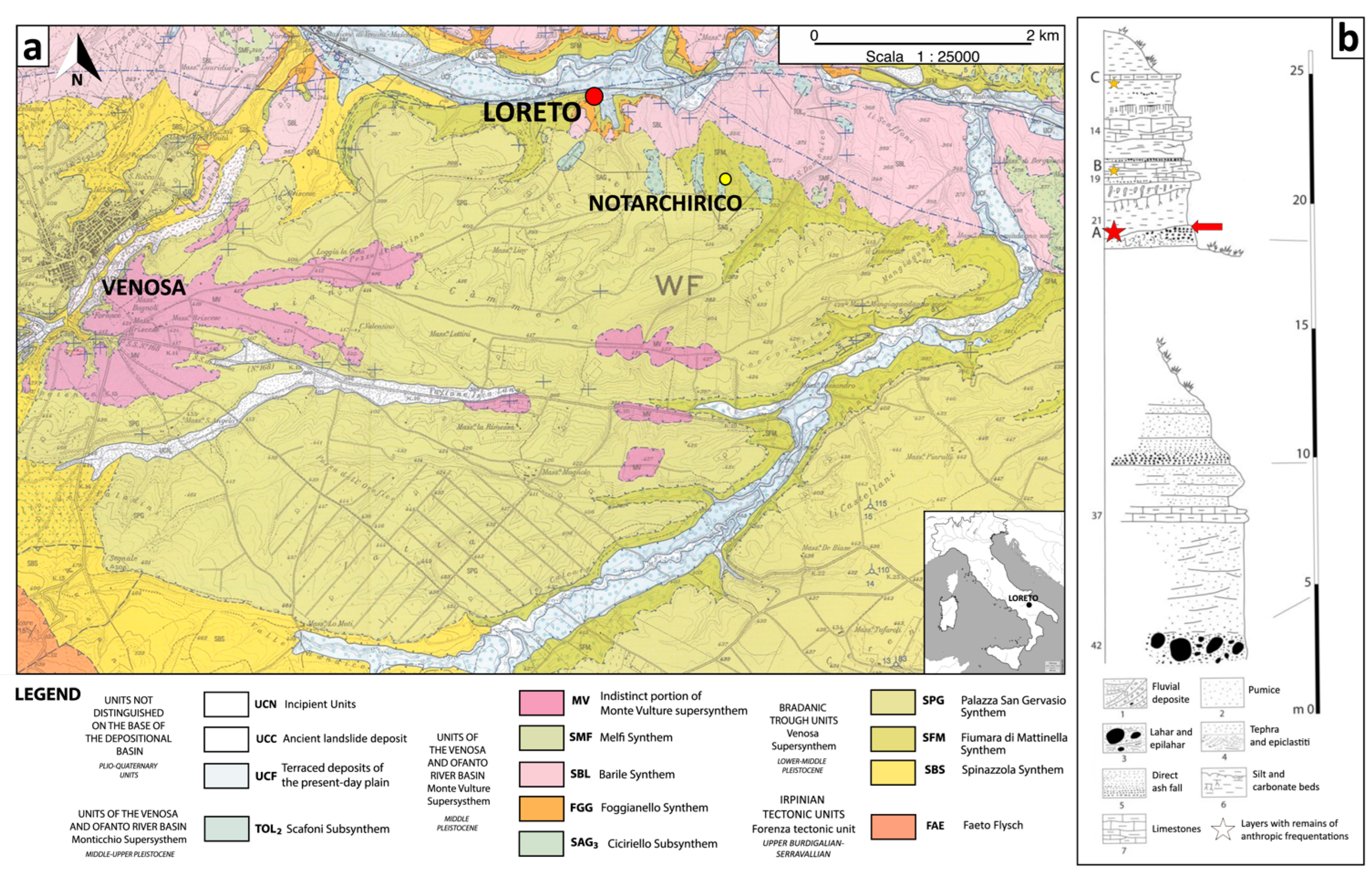
1.2. Geological Background
2. Materials
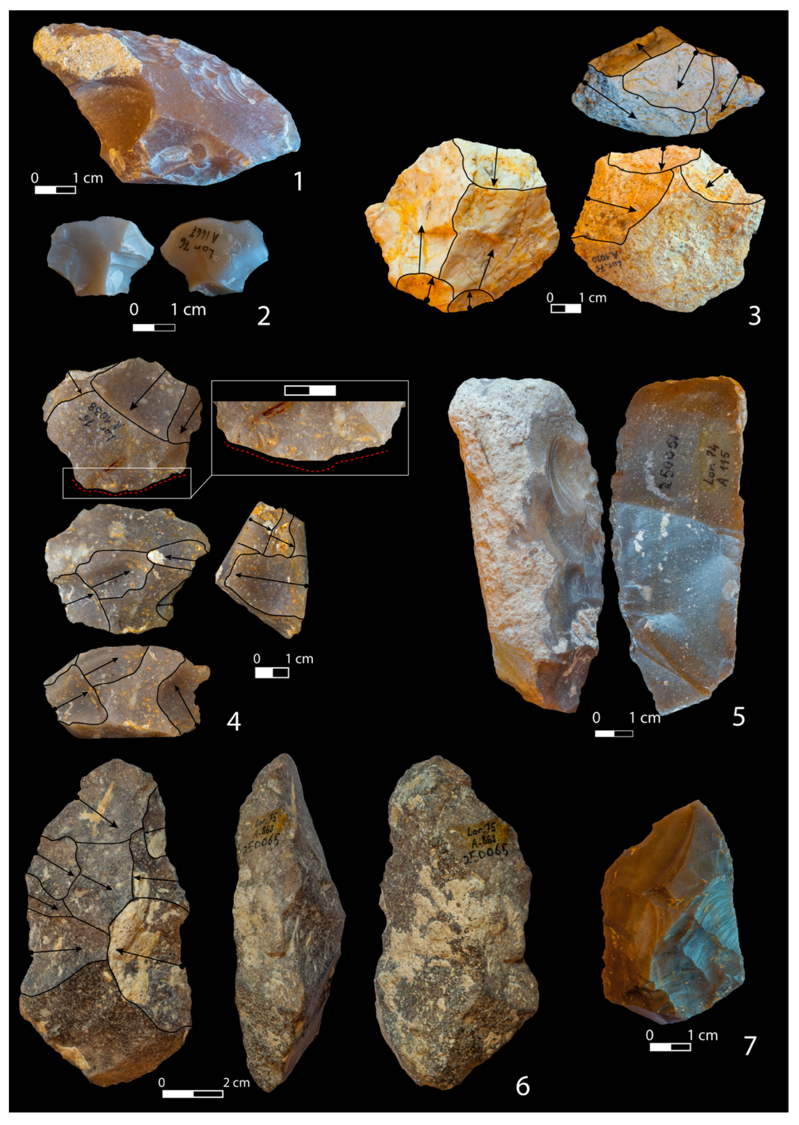
2.1. Artifacts
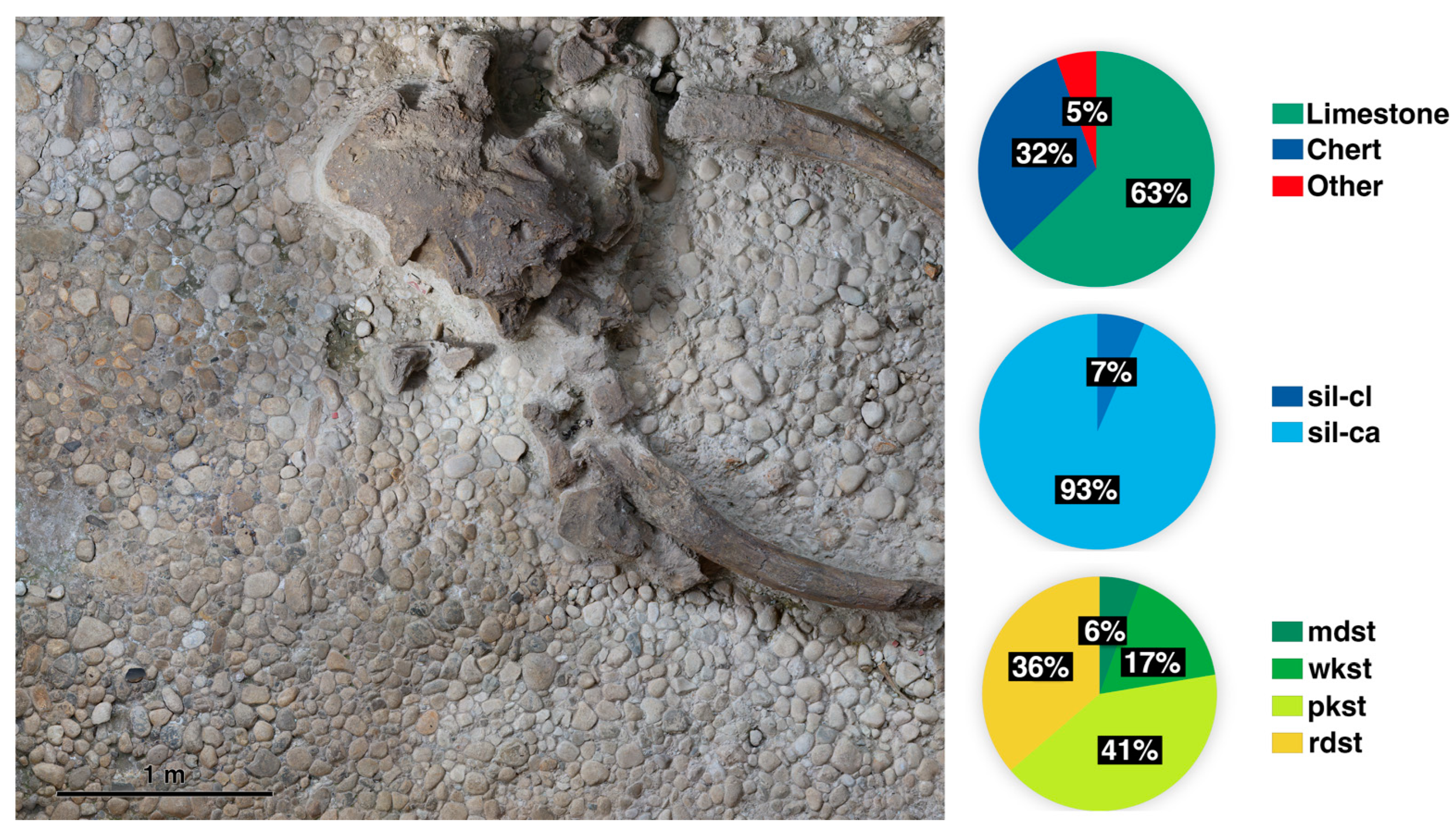
2.2. Geological Samples from Layer B of Notarchirico
2.3. SiLiBA Lithoheque Samples
3. Methods
4. Results
4.1. Petrography
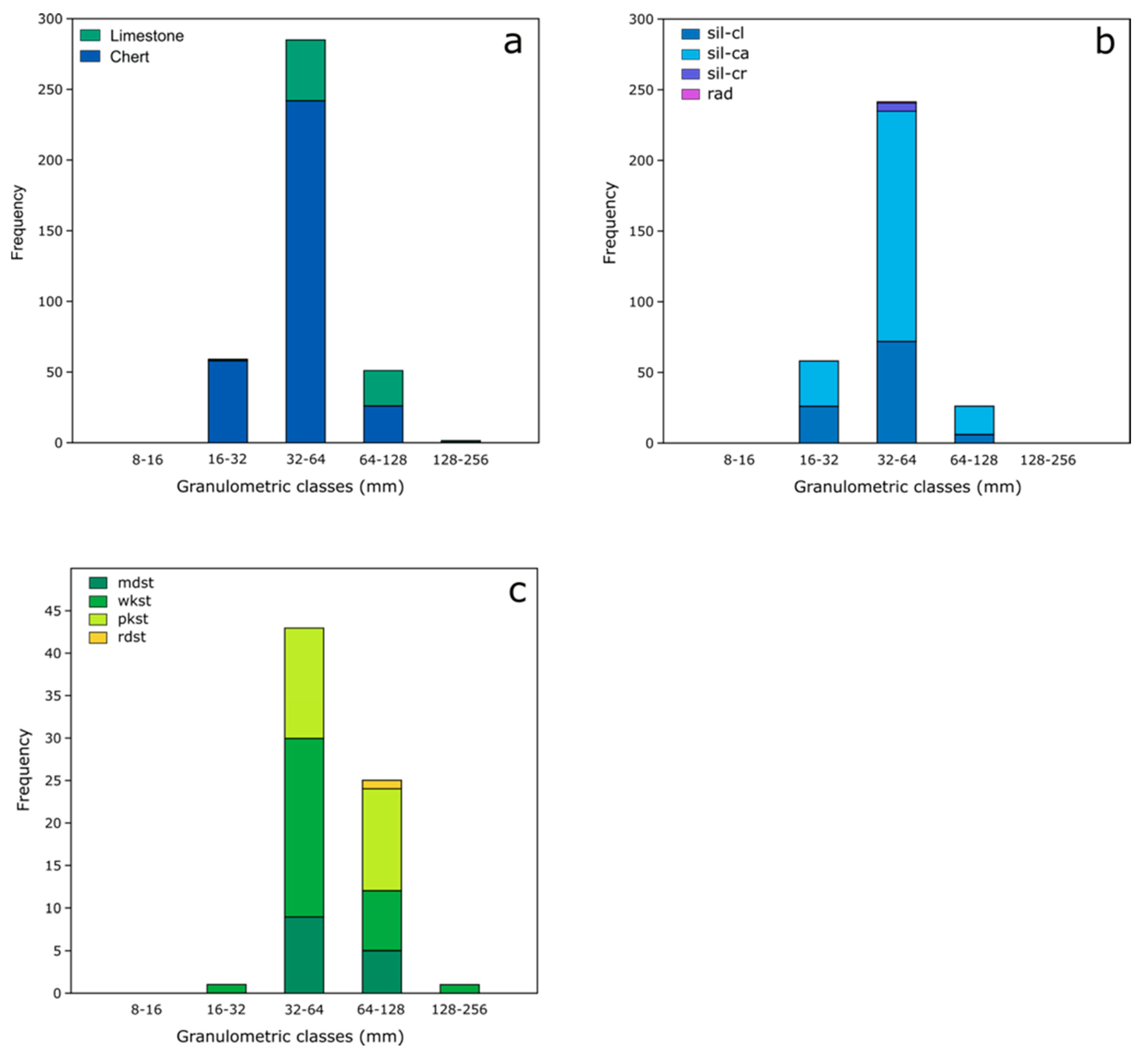
4.2. Size Analysis
5. Discussion
6. Conclusions
Supplementary Materials
Author Contributions
Funding
Data Availability Statement
Acknowledgments
Conflicts of Interest
References
- Inizan, M.; Tixier, J.; Roche, H.; Reduron-Ballinger, M. Technologie de La Pierre Taillée; Préhistoire de la Pierre Taillée; CREP: Meudon, France, 1994; Volume 4. [Google Scholar]
- Luedtke, B.E. An Archaeologist’s Guide to Chert and Flint; Archaeological Research Tools; Institute of Archaeology, University of California: Los Angeles, CA, USA, 1992. [Google Scholar]
- D’Angelo, E.; Mussi, M. Galets et Lamelles de l’Aurignacien Du Latium (Italie Centrale): Le Cas de Grotta Barbara. In Production Lamellaires Attribees A L’aurignacien: Chaines Operatoires et Perspectives Technoculturelles; e Brun-Ricalens, F., Bordes, J.G., Bon, F., Eds.; Musée National d’Histoire et d’Art du Luxembourg: Luxembourg, 2005; pp. 313–322. [Google Scholar]
- Guyodo, J.-N.; Marchand, G. La percussion bipolaire sur enclume dans l’Ouest de la France de la fin du Paléolithique au Chalcolithique: Une lecture économique et sociale. Bull. Soc. Préhist. Fr. 2005, 102, 539–549. [Google Scholar] [CrossRef]
- Bietti, A.; Cancellieri, E.; Corinaldesi, C.; Grimaldi, S.; Spinapolice, E. La Percussion Sur Enclume En Italie Centrale Tyrrhénienne. Paléo 2010, 143–180. [Google Scholar] [CrossRef]
- Furestier, R. La Percussion Directe Dure Au Campaniforme: Modalités d’application et Difficultés d’interprétation. Paléo 2010, 189–200. [Google Scholar] [CrossRef]
- Kaczanowksa, M.; Kozlowski, J.K.; Sobczyk, K. Upper Palaeolithic Human Occupations and Material Culture at Klisoura Cave i. Eurasian Prehistory 2010, 7, 133–285. [Google Scholar]
- Osipowicz, G.; Piličiauskas, G. The Processing and Use of Flint in the Metal Ages: A Few Cases from the Kernavė and Naudvaris Sites in Lithuania. Archaeol. Balt. 2010, 13, 110–124. [Google Scholar]
- Tomasso, A. Territoire de mobilité et territoire social: Structuration du territoire d’approvisionnement en matières premières lithiques dans l’Épigravettien récent au nord-ouest de l’Italie. Bull. Soc. Préhist. Fr. 2018, 115, 677–700. [Google Scholar] [CrossRef]
- Collina, C. Le Néolithique Ancien en Italie Du Sud: Evolution Des Industries Lithiques Entre VIIe et VIe Millénaire; Archaeopress Publishing Ltd.: Bicester, UK, 2016. [Google Scholar] [CrossRef]
- Van Kolfschoten, T.; Parfitt, S.A.; Serangeli, J.; Bello, S.M. Lower Paleolithic Bone Tools from the ‘Spear Horizon’ at Schöningen (Germany). J. Hum. Evol. 2015, 89, 226–263. [Google Scholar] [CrossRef] [PubMed]
- Arzarello, M.; De Weyer, L.; Peretto, C. The First European Peopling and the Italian Case: Peculiarities and “Opportunism”. Quat. Int. 2016, 393, 41–50. [Google Scholar] [CrossRef]
- Peresani, M.; Bertola, S.; Delpiano, D.; Benazzi, S.; Romandini, M. The Uluzzian in the North of Italy: Insights around the New Evidence at Riparo Broion. Archaeol. Anthropol. Sci. 2019, 11, 3503–3536. [Google Scholar] [CrossRef]
- Roebroeks, W.; Gaudzinski-Windheuser, S.; Baales, M.; Kahlke, R.-D. Uneven Data Quality and the Earliest Occupation of Europe—The Case of Untermassfeld (Germany). J. Paleolit. Archaeol. 2018, 1, 5–31. [Google Scholar] [CrossRef]
- Ricci, G.; Vadillo Conesa, M.; Martini, F. Through Diachronic Discontinuities and Regionalization: The Contribution of the Analysis of the Lithic Industries from Grotta Della Serratura (Strata 10-9) in the Definition of Epigravettian in the Southern Italian Peninsula. J. Archaeol. Sci. Rep. 2019, 24, 175–191. [Google Scholar] [CrossRef]
- Gallotti, R.; Mohib, A.; Fernandes, P.; El Graoui, M.; Lefèvre, D.; Raynal, J.-P. Dedicated Core-on-Anvil Production of Bladelet-like Flakes in the Acheulean at Thomas Quarry I-L1 (Casablanca, Morocco). Sci. Rep. 2020, 10, 9225. [Google Scholar] [CrossRef] [PubMed]
- Moncel, M.-H.; Santagata, C.; Pereira, A.; Nomade, S.; Voinchet, P.; Bahain, J.-J.; Daujeard, C.; Curci, A.; Lemorini, C.; Hardy, B.; et al. The Origin of Early Acheulean Expansion in Europe 700 Ka Ago: New Findings at Notarchirico (Italy). Sci. Rep. 2020, 10, 13802. [Google Scholar] [CrossRef] [PubMed]
- Moncel, M.-H.; Lemorini, C.; Eramo, G.; Fioretti, G.; Daujeard, C.; Curci, A.; Berto, C.; Hardy, B.; Pineda, A.; Rineau, V.; et al. A Taphonomic and Spatial Distribution Study of the New Levels of the Middle Pleistocene Site of Notarchirico (670–695 Ka, Venosa, Basilicata, Italy). Archaeol. Anthropol. Sci. 2023, 15, 106. [Google Scholar] [CrossRef]
- Muntoni, I.M.; Delluniversità, E.; Allegretta, I.; Terzano, R.; Eramo, G. Chert Sources and Early to Middle Neolithic Exploitation in the Tavoliere (Northern Apulia, Italy). Quat. Int. 2022, 615, 43–65. [Google Scholar] [CrossRef]
- Ranaldo, F.; Massafra, D.; Kitagawa, K. Neanderthals of Porto Selvaggio in Southern Italy: Lithic Industry of Grotta Torre Dell’Alto (Nardò, Lecce). J. Quat. Sci. 2022, 37, 257–267. [Google Scholar] [CrossRef]
- Rossini, M.; Marciani, G.; Arrighi, S.; Pereira Santos, M.C.; Spagnolo, V.; Ronchitelli, A.; Benazzi, S.; Moroni, A. Less Is More! Uluzzian Technical Behaviour at the Cave Site of Castelcivita (Southern Italy). J. Archaeol. Sci. Rep. 2022, 44, 103494. [Google Scholar] [CrossRef]
- Moscone, D.; D’Errico, D.; Pellegrini, D.; Pellegrini, A.; Nobile, E.; Lemorini, C. Arslantepe in the Foreground: The Economic and Social Role of the Large Blades at the End of the 4th Millennium BC. J. Archaeol. Sci. Rep. 2024, 56, 104544. [Google Scholar] [CrossRef]
- Moyano, I.T.; Barsky, D.; Cauche, D.; Celiberti, V.; Grégoire, S.; Lebegue, F.; Moncel, M.H.; De Lumley, H. The Archaic Stone Tool Industry from Barranco León and Fuente Nueva 3, (Orce, Spain): Evidence of the Earliest Hominin Presence in Southern Europe. Quat. Int. 2011, 243, 80–91. [Google Scholar] [CrossRef]
- Garcia, J.; Martínez, K.; Carbonell, E. The Early Pleistocene Stone Tools from Vallparadís (Barcelona, Spain): Rethinking the European Mode 1. Quat. Int. 2013, 316, 94–114. [Google Scholar] [CrossRef]
- Arzarello, M.; Bertola, S.; Fontana, F.; Guerreschi, A.; Liagre, J.; Peretto, C. Modalità Di Approvvigionamento Delle Materie Prime Nel Sito Di Riparo Tagliente (Stallavena Di Grezzane, Verona). In Quali Differenze Nei Comportamenti Tecno-Economici Tra Musteriano Ed Epigravettiano; Cocchi Genick, D., Ed.; Università Degli Studi Di Ferrara: Ferrara, Italy, 2006; pp. 357–361. [Google Scholar]
- Breuil, H. Le Gisement à Sinanthropus de Chou-Kou-Tien (Chine) et Ses Vestiges de Feu et d’industrie. Anthropos 1932, 27, 58–65. [Google Scholar] [CrossRef]
- Mourre, V. Le Débitage Sur Enclume Au Paléolithique Inferieur et Moyen; Techniques Methodes at Schemas Conceptuels; Paris Nanterre University: Nanterre, France, 1996; pp. 1–55. [Google Scholar]
- Mourre, V.; Jarry, M.; Colonge, D.; Lelouvier, L.-A. Le Débitage Sur Enclume Aux Bosses (Lamagdelaine, Lot, France). Paléo 2010, 49–62. [Google Scholar] [CrossRef]
- De Lumley, H.; Nioradzé, M.; Barsky, D.; Cauche, D.; Celiberti, V.; Nioradzé, G.; Notter, O.; Zvania, D.; Lordkipanidze, D. Les industries lithiques préoldowayennes du début du Pléistocène inférieur du site de Dmanissi en Géorgie. L’Anthropologie 2005, 109, 1–182. [Google Scholar] [CrossRef]
- Diez-Martín, F.; Sánchez, P.; Domínguez-Rodrigo, M.; Mabulla, A.; Barba, R. Were Olduvai Hominins Making Butchering Tools or Battering Tools? Analysis of a Recently Excavated Lithic Assemblage from BK (Bed II, Olduvai Gorge, Tanzania). J. Anthropol. Archaeol. 2009, 28, 274–289. [Google Scholar] [CrossRef]
- Prous, A.; Alonso, M.; Souza, G.N.D.; Lima, A.P.; Amoreli, F. La Place et Les Caractéristiques Du Débitage Sur Enclume (« bipolaire ») Dans Les Industries Brésiliennes. Paléo 2010, 201–219. [Google Scholar] [CrossRef]
- Barsky, D.; Chapon-Sao, C.; Bahain, J.-J.; Beyene, Y.; Cauche, D.; Celiberti, V.; Desclaux, E.; De Lumley, H.; De Lumley, M.-A.; Marchal, F.; et al. The Early Oldowan Stone-Tool Assemblage from Fejej FJ-1A, Ethiopia. J. Afr. Archaeol. 2011, 9, 207–224. [Google Scholar] [CrossRef]
- Gurtov, A.N.; Eren, M.I. Lower Paleolithic Bipolar Reduction and Hominin Selection of Quartz at Olduvai Gorge, Tanzania: What’s the Connection? Quat. Int. 2014, 322–323, 285–291. [Google Scholar] [CrossRef]
- Wang, W.; Bae, C.J.; Huang, S.; Huang, X.; Tian, F.; Mo, J.; Huang, Z.; Huang, C.; Xie, S.; Li, D. Middle Pleistocene Bifaces from Fengshudao (Bose Basin, Guangxi, China). J. Hum. Evol. 2014, 69, 110–122. [Google Scholar] [CrossRef] [PubMed]
- Li, F. An Experimental Study of Bipolar Reduction at Zhoukoudian Locality 1, North China. Quat. Int. 2016, 400, 23–29. [Google Scholar] [CrossRef]
- De Lombera-Hermida, A.; Rodríguez-Álvarez, X.P.; Peña, L.; Sala-Ramos, R.; Despriée, J.; Moncel, M.-H.; Gourcimault, G.; Voinchet, P.; Falguères, C. The Lithic Assemblage from Pont-de-Lavaud (Indre, France) and the Role of the Bipolar-on-Anvil Technique in the Lower and Early Middle Pleistocene Technology. J. Anthropol. Archaeol. 2016, 41, 159–184. [Google Scholar] [CrossRef]
- Yang, S.-X.; Hou, Y.-M.; Yue, J.-P.; Petraglia, M.D.; Deng, C.-L.; Zhu, R.-X. The Lithic Assemblages of Xiaochangliang, Nihewan Basin: Implications for Early Pleistocene Hominin Behaviour in North China. PLoS ONE 2016, 11, e0155793. [Google Scholar] [CrossRef] [PubMed]
- Villa, P.; Pollarolo, L.; Conforti, J.; Marra, F.; Biagioni, C.; Degano, I.; Lucejko, J.J.; Tozzi, C.; Pennacchioni, M.; Zanchetta, G.; et al. From Neandertals to Modern Humans: New Data on the Uluzzian. PLoS ONE 2018, 13, e0196786. [Google Scholar] [CrossRef] [PubMed]
- Ollé, A.; Mosquera, M.; Rodríguez, X.P.; De Lombera-Hermida, A.; García-Antón, M.D.; García-Medrano, P.; Peña, L.; Menéndez, L.; Navazo, M.; Terradillos, M.; et al. The Early and Middle Pleistocene Technological Record from Sierra de Atapuerca (Burgos, Spain). Quat. Int. 2013, 295, 138–167. [Google Scholar] [CrossRef]
- Caruana, M.V. Lithic Production Strategies in the Oldowan Assemblages from Sterkfontein Member 5 and Swartkrans Member 1, Gauteng Province, South Africa. J. Afr. Archaeol. 2017, 15, 1–19. [Google Scholar] [CrossRef]
- Chauhan, P.R. Soanian Cores and Core-Tools from Toka, Northern India: Towards a New Typo-Technological Organization. J. Anthropol. Archaeol. 2007, 26, 412–441. [Google Scholar] [CrossRef]
- Garcia, A.M.; Da Silva, B.G. Arqueologia experimental aplicada ao estudo das boleadeiras pré-coloniais da região platina. Cad. Do LEPAARQ 2013, 10, 89–120. [Google Scholar] [CrossRef]
- De La Torre, I.; Mora, R. Technological Behaviour in the Early Acheulean of EF-HR (Olduvai Gorge, Tanzania). J. Hum. Evol. 2018, 120, 329–377. [Google Scholar] [CrossRef]
- Slimak, L. The Neronian and the Historical Structure of Cultural Shifts from Middle to Upper Palaeolithic in Mediterranean France. J. Archaeol. Sci. 2008, 35, 2204–2214. [Google Scholar] [CrossRef]
- Mussi, M.; Altamura, F.; Macchiarelli, R.; Melis, R.T.; Spinapolice, E.E. Garba III (Melka Kunture, Ethiopia): A MSA Site with Archaic Homo Sapiens Remains Revisited. Quat. Int. 2014, 343, 28–39. [Google Scholar] [CrossRef]
- Kuman, K.; Gibbon, R.J. The Rietputs 15 Site and Early Acheulean in South Africa. Quat. Int. 2018, 480, 4–15. [Google Scholar] [CrossRef]
- Güleç, E.; White, T.; Kuhn, S.; Özer, I.; Saǧır, M.; Yılmaz, H.; Howell, F.C. The Lower Pleistocene Lithic Assemblage from Dursunlu (Konya), Central Anatolia, Turkey. Antiquity 2009, 83, 11–22. [Google Scholar] [CrossRef]
- Geneste, J.M. L’approvisionnement En Matière Première Dans Les Systèmes de Production Lithique: La Dimension Spatiale de La Technologie. Technol. Cadenas Oper. Liticas Treb. D’Archeol. 1992, 1, 1–36. [Google Scholar]
- Porraz, G.; Negrino, F. Espaces Économiques et Approvisionnement Minéral Au Paléolithique Moyen Dans l’aire Liguro-Provençale. Bull. Mus. D’anthropol. Préhist. Monaco 2008, (Suppl. S1), 29–39. Available online: https://www.google.com/url?sa=t&source=web&rct=j&opi=89978449&url=https://shs.hal.science/halshs-02517837/document&ved=2ahUKEwjRtrGEpPCNAxVE1TgGHRmdIE4QFnoECBcQAQ&usg=AOvVaw2YytXdzdglS5jE-HCyTQv5 (accessed on 6 May 2025).
- Maier, A. Population and Settlement Dynamics from the Gravettian to the Magdalenian. Mitteilungen Ges. Für Urgesch. 2017, 26, 83–101. [Google Scholar]
- Bressy, C. Caractérisation et Gestion Du Silex Des Sites Mésolithiques et Néolithiques Du Nord-Ouest de l’Arc Alpin. Une Approche Pétrographique et Géochimique: Résumé de Thèse Par l’auteur. Université de Provence, Juin 2002, t. I, 341 p. Préhistoires Méditerr. 2002, 10–11, 231–235. [Google Scholar] [CrossRef]
- Fernandes, P.; Raynal, J.-P. Pétroarchéologie du silex: Un retour aux sources. Comptes Rendus Palevol 2006, 5, 829–837. [Google Scholar] [CrossRef]
- Fernandez, R.; Martirena, F.; Scrivener, K.L. The Origin of the Pozzolanic Activity of Calcined Clay Minerals: A Comparison between Kaolinite, Illite and Montmorillonite. Cem. Concr. Res. 2011, 41, 113–122. [Google Scholar] [CrossRef]
- Delluniversità, E.; Allegretta, I.; Muntoni, I.M.; Tarantini, M.; Terzano, R.; Eramo, G. Distribution and Compositional Fingerprints of Primary and Secondary Chert Sources in Northern Apulia (Italy). J. Cult. Herit. 2020, 42, 213–225. [Google Scholar] [CrossRef]
- Delluniversità, E.; Muntoni, I.M.; Allegretta, I.; Tarantini, M.; Monno, A.; Maiorano, P.; Girone, A.; Morsilli, M.; Terzano, R.; Eramo, G. Development of a Multiparametric Characterisation Protocol for Chert Investigation and Application on the Gargano Promontory Mines. Archaeol. Anthropol. Sci. 2019, 11, 6037–6063. [Google Scholar] [CrossRef]
- Moscone, D.; Eramo, G.; Caggiani, M.C.; Morandi Bonacossi, D.; Conati Barbaro, C. Compositional Features of Cherts from the Jebel Zawa Mines (Dohuk, Kurdistan Region of Iraq) and Implications for Exploitation Strategies during the Late Chalcolithic/Early Bronze Age. J. Archaeol. Sci. Rep. 2020, 29, 102086. [Google Scholar] [CrossRef]
- Fernandes, P. Itinéraires et Transformations Du Silex: Une Pétroarchéologie Refondée, Application Au Paléolithique Moyen; Université de Bordeaux: Bordeaux, France, 2012. [Google Scholar]
- Sieveking, G.D.G.; Bush, P.; Ferguson, J.; Craddock, P.T.; Hughes, M.J.; Cowell, M.R. Prehistoric flint mines and their identification as sources of raw material. Archaeometry 1972, 14, 151–176. [Google Scholar] [CrossRef]
- Luedtke, B.E. Chert Sources and Trace-Element Analysis. Am. Antiq. 1978, 43, 413–423. [Google Scholar] [CrossRef]
- Luedtke, B.E. The Identification of Sources of Chert Artifacts. Am. Antiq. 1979, 44, 744–757. [Google Scholar] [CrossRef]
- Selivanova, N. The Methods of Source Determination of Flint for Archaeological Sites. In Reports, III Seminar in Petro-Archaeology. Bulgarian Academy of Science; Kunchev, K.S., Nachev, I.K., Eds.; Bulgarian Academy of Science: Plovdiv, Bulgaria, 1984; pp. 93–102. [Google Scholar]
- Seronie-Vivien, M.; Seronie-Vivien, M.R. Les Silex Du Mésozoïque Nord-Aquitain. Approche Géologique de l’étude Des Silex Pour Servir à La Recherche Préhistorique. Suppl. Au Tome Bull. Soc. Linn. 1987, VI, 129–132. [Google Scholar]
- Tarantini, M.; Eramo, G.; Monno, A.; Muntoni, I.M. Gargano Promontory Chert: Mining Practices and Archaeometric Characterisation. Séances Soc. Préhist. Fr. 2016, 5, 249–267. [Google Scholar]
- Masson, A. Pétroarchéologie Des Roches Siliceuses; Université Lyon: Lyon, France, 1981. [Google Scholar]
- Dunham, R.J. Classification of carbonate rocks according to depositional texture. In Classification of Carbonate Rocks; Ham, W.E., Ed.; American Association of Petroleum Geologists: Tulsa, OK, USA, 1962; p. 108. [Google Scholar]
- Hess, S.C. Chert Provenance Analysis at the Mack Canyon Site, Sherman County, Oregon: An Evaluative Study. Geoarchaeology 1996, 11, 51–81. [Google Scholar] [CrossRef]
- Malyk-Selivanova, N.; Ashley, G.M.; Gal, R.; Glascock, M.D.; Neff, H. Geological–Geochemical Approach to “Sourcing” of Prehistoric Chert Artifacts, Northwestern Alaska. Geoarchaeology 1998, 13, 673–708. [Google Scholar] [CrossRef]
- Bertola, S. Approccio Micropaleontologico Discriminante per Riconoscere La Provenienza Alpina o Appenninica Delle Selci Della Scaglia Rossa (Italia Centro-Settentrionale). Bull. Mus. Anthropol. Préhist. Monaco 2012, 52, 17–27. [Google Scholar]
- Bertola, S.; Lo Vetro, D.; Schirolli, P.; Confortini, F.; Malzanni, M.; Pallecchi, P. Le Risorse Litiche Scheggiabili Delle Prealpi Della Lombardia Centro-Orientale: Primi Dati per Una Caratterizzazione Degli Areali Di Approvvigionamento Delle Materie Prime Usate Durante La Preistoria. Riv. Di Sci. Preist. 2022, 52, 217–237. [Google Scholar]
- Bertola, S. The Flints of Southern Alps (Non Valley, Italy) Provenance Found in the Mesolithic Site of Ullafelsen (Sellrain, Tyrol). In Das Mesolithikum-Projekt Ullafelsen (Teil 1). Mensch und Umwelt im Holozän Tirols, 1; Schäfer, D., Ed.; Philipp von Zabern: Innsbruck, Austria, 2011; pp. 463–505. [Google Scholar]
- Bertola, S.; Fontana, F.; Visentin, D. Lithic Raw Material Circulation and Settlement Dynamics in the Upper Palaeolithic of the Venetian Prealps (NE Italy). A Key-Role for Palaeoclimatic and Landscape Changes across the LGM. In Palaeolithic Italy. Advanced Studies on Early Human Adaptations in the Apennine Peninsula; Borgia, V., Cristiani, E., Eds.; Sidestone Press: Leiden, The Netherlands, 2018; pp. 219–246. [Google Scholar]
- D’Erasmo, G. La Faune Di Grotta Di Loretello Presso Venosa. Atti Accad. Delle Sci. Fis. E Mat. 1932, 4, 1–17. [Google Scholar]
- Blanc, L. Venosa, Gisement à Industrie Tayacienne et Micoquienne de Loreto. In Proceedings of the IV Congress Internationale INQUA, Livret Guide, Rome, Italy; 1953; pp. 63–68. Available online: https://en.wikipedia.org/wiki/International_Union_for_Quaternary_Research (accessed on 6 May 2025).
- Chiappella, G. Il Paleolitico Inferiore Di Venosa. Boll. Paletnologia Ital. 1964, 73, 7–23. [Google Scholar]
- Bonifay, M.F. Liste Préliminaire de La Grande Faune Du Gisement Préhistorique de Venosa (Basilicata, Italie): Fouilles 1974-76. Bull. Mus. D’Anthropol. Préhist. Monaco 1977, 21, 116–125. [Google Scholar]
- Barral, L.; Chiappella, G.; Simone, S. Datazione Relativa Del Giacimento Di Loreto (Venosa, Basilicata). In Atti della XX Riunione Scientifica in Basilicata 16–20 Ottobre 1976; Istituto Italiano di Preistoria e Protostoria: Firenze, France, 1978; pp. 125–132. [Google Scholar]
- Barral, L.; Simone, S. Le Bassin Fluvio-Lacustre de Venosa (Basilicata, Italie). Bull. Mus. D’anthropol. Préhist. Monaco 1983, 27, 5–19. [Google Scholar]
- Pereira, A.; Moncel, M.-H.; Nomade, S.; Voinchet, P.; Shao, Q.; Falguères, C.; Lefèvre, D.; Raynal, J.P.; Scao, V.; Piperno, M.; et al. Update and Synthesis of the Available Archaeological and Geochronological Data for the Lower Paleolithic Site of Loreto at Venosa (Basilicata, Italy). Quat. Res. 2024, 119, 12–27. [Google Scholar] [CrossRef]
- Crovetto, C. Le Paleolithique Inferieur de Loreto. Bull. Mus. D’anthropol. Prehist. Monaco 1993, 36, 31–57. [Google Scholar]
- Angelelli, F.; Caloi, L.; Palombo, M.R. Fauna Quaternaria Di Venosa: Cenni Preliminari. In Atti della XX Riunione Scientifica in Basilicata 16–20 Ottobre 1976; Istituto Italiano di Preistoria e Protostoria: Firenze, France, 1978; pp. 133–140. [Google Scholar]
- Alberdi, M.; Caloi, L.; Palombo, M.R. The Quaternary Fauna of Venosa: Equids. Bull. Mus. D’anthropol. Préhist. Monaco 1988, 31, 1–39. [Google Scholar]
- Pineda, A.; Mecozzi, B.; Iannucci, A.; Carpentieri, M.; Sardella, R.; Simone, S.; Moncel, M.H. Hominin and carnivore roles during the early Middle Pleistocene: New data from Loreto (Venosa Basin, southern Italy). Hist. Biol. 2025; submitted. [Google Scholar]
- Durante, S.; Settepassi, F. Nota Sulle Associazioni Malacologiche Del Giacimento Fluviolacustre Di Loreto, Venosa. In Atti XX Riunione Scientifica dell’Istituto Italiano di Preistoria e Protostoria (1978); Istituto Italiano di Preistoria e Protostoria: Firenze, Italy, 1978; pp. 141–145. [Google Scholar]
- Giannandrea, P. Evoluzione Sedimentaria Della Successione Alluvionale e Lacustre Quaternaria Del Bacino Di Venosa (Italia Meridionale). Alp. Mediterr. Quat. 2009, 22, 269–290. [Google Scholar]
- Bonadonna, F.P.; Brocchini, D.; Laurenzi, M.A.; Principe, C.; Ferrara, G. Stratigraphical and chronological correlations between monte vulture volcanics and sedimentary deposits of the venosa basin. Quat. Int. 1998, 47–48, 87–96. [Google Scholar] [CrossRef]
- Giannandrea, P.; Marino, M.; Romeo, M.; Schiattarella, M. Pliocene to Quaternary Evolution of the Ofanto Basin in Southern Italy: An Approach Based on the Unconformity-Bounded Stratigraphic Units. Ital. J. Geosci. 2014, 133, 27–44. [Google Scholar] [CrossRef]
- Patacca, E.; Scandone, P. Geology of the Southern Apennines. Boll. Della Soc. Geol. Ital. 2007, 7, 75–119. [Google Scholar]
- Casnedi, R. La Fossa Bradanica: Origine, Sedimentazione e Migrazione. Mem. Soc. Geol. Ital. 1988, 41, 439–448. [Google Scholar]
- Patacca, E.; Scandone, P. Late Thrust Propagation and Sedimentary Response in the Thrust-Belt—Foredeep System of the Southern Apennines (Pliocene-Pleistocene). In Anatomy of an Orogen: The Apennines and Adjacent Mediterranean Basins; Vai, G.B., Martini, I.P., Eds.; Springer: Dordrecht, The Netherlands, 2001; pp. 401–440. [Google Scholar] [CrossRef]
- Tropeano, M.; Sabato, L.; Pieri, P. Filling and Cannibalization of a Foredeep: The Bradanic Trough, Southern Italy. Geol. Soc. Lond. Spec. Publ. 2002, 191, 55–79. [Google Scholar] [CrossRef]
- Catalano, S.; Monaco, C.; Tortorici, L.; Paltrinieri, W.; Steel, N. Neogene-Quaternary Tectonic Evolution of the Southern Apennines. Tectonics 2004, 23, 2003TC001512. [Google Scholar] [CrossRef]
- Pieri, P.; Sabato, L.; Tropeano, M. Significato Geodinamico Dei Caratteri Deposizionali e Strutturali Della Fossa Bradanica Nel Pleistocene. Mem. Soc. Geol. Ital. 1996, 51, 501–515. [Google Scholar]
- Ciaranfi, N.; Pieri, P.; Ricchetti, G. Note Alla Carta Geologica Delle Murge e Del Salento (Puglia Centromeridionale). Mem. Soc. Geol. Ital. 1988, 41, 449–460. [Google Scholar]
- Doglioni, C.; Tropeano, M.; Mongelli, F.; Pieri, P. Middle-Late Pleistocene Uplift of Puglia: An “Anomaly” in the Apenninic Foreland. Mem. Soc. Geol. It. 1996, 51, 101–117. [Google Scholar]
- Azzillonna, V.; Contillo, L.; Corrado, G.; Dimola, G.; Giaccari, E.; Giannandrea, P.; Gioia, D.; Schiattarella, M. Multistadial Physiographic Evolution of the Bradano River Catchment in Southern Italy. Geogr. Fis. Din. Quat. 2023, 46, 125–134. [Google Scholar] [CrossRef]
- Colella, A.; Giannandrea, P.; Lazzari, M.; Longhitano, S.; Schiattarella, M. Note Illustrative Della Carta Geologica d’Italia Alla Scala 1:50.000, Foglio 254, Rionero in Vulture; APAT, Dipartimento Difesa del Suolo, Servizio Geologico d’Italia: Roma, Italy, 2014; p. 96. [Google Scholar]
- Raynal, J.P.; Lefèvre, D.; Vernet, G.; Pilleyre, T.; Sanzelle, S.; Fain, J.; Miallier, D.; Montret, M. Sedimentary dynamics and tecto-volcanism in the venosa basin (basilicata, italia). Quat. Int. 1998, 47–48, 97–105. [Google Scholar] [CrossRef]
- Pereira, A.; Nomade, S.; Voinchet, P.; Bahain, J.J.; Falguères, C.; Garon, H.; Lefèvre, D.; Raynal, J.P.; Scao, V.; Piperno, M. The Earliest Securely Dated Hominin Fossil in Italy and Evidence of Acheulian Occupation during Glacial MIS 16 at Notarchirico (Venosa, Basilicata, Italy). J. Quat. Sci. 2015, 30, 639–650. [Google Scholar] [CrossRef]
- Baissas, P. Données Paléomagnétiques et Sédimentologiques Sur Les Dépôts de La Coupe de Loreto, Venosa. Bull. Mus. D’Anthropol. Préhist. Monaco 1980, 24, 13–56. [Google Scholar]
- Lefèvre, D.; Raynald, J.P.; Vernet, G. Enregistrements Plehistocenes Dans Le Bassin de Venosa. In Notarchirico. Un sito del Pleistocene Medio Iniziale Nel Bacino Di Venosa; Piperno, M., Ed.; Edizioni Osanna Venosa: Venosa, Italy, 1999; pp. 134–174. [Google Scholar]
- Lefèvre, D.; Raynal, J.-P.; Vernet, G.; Kieffer, G.; Piperno, M. Tephro-Stratigraphy and the Age of Ancient Southern Italian Acheulean Settlements: The Sites of Loreto and Notarchirico (Venosa, Basilicata, Italy). Quat. Int. 2010, 223–224, 360–368. [Google Scholar] [CrossRef]
- Gagnepain, J. Etude Magnétostratigraphique de Sites Du Pléistocène Inférieur et Moyen Des Alpes-Maritimes et d’Italie: Grotte Du Vallonet, Marina Airport, Ca’Belvedere Di Monte Poggiolo, Isernia La Pineta, Venosa Loreto; Muséum National d’Histoire Naturelle: Paris, France, 1996. [Google Scholar]
- Singer, B.S. A Quaternary Geomagnetic Instability Time Scale. Quat. Geochronol. 2014, 21, 29–52. [Google Scholar] [CrossRef]
- Villa, I.M.; Buettner, A. Chronostratigraphy of Monte Vulture Volcano (Southern Italy): Secondary Mineral Microtextures and 39Ar-40Ar Systematics. Bull. Volcanol. 2009, 71, 1195–1208. [Google Scholar] [CrossRef]
- Brocchini, D. Il Vulcano Vulture (Basilicata). Master’s Thesis, Cronología Radiometrica Ed Evoluzione, Università di Pisa, Pisa, Italy, 1993. [Google Scholar]
- Piperno, M.; Lefèvre, D.; Raynald, J.P.; Tagliacozzo, A. Conclusioni Generali. In Notarchirico. Un Sito Del Pleistocene Medio-Antico Nel Bacino Di Venosa (Basilicata); Osanna: Venosa, Italy, 1999; pp. 537–543. [Google Scholar]
- Carpentieri, M.; Fioretti, G.; Pineda, A.; Mecozzi, B.; Iannucci, A.; Eramo, G.; Arzarello, M.; Simone, S.; Moncel, M.H. The Lithic Legacy of Loreto: A Technological Perspective on Early Hominin Toolmaking during Lower Palaeolithic. Hist. Biol. 2025; submitted. [Google Scholar]
- Leroi-Gourhan, A. Le Geste et la parole.2, La Mémoire et les rythmes; Sciences d’aujourd’hui; Albin Michel: Paris, France, 1988. [Google Scholar]
- Goodale, N.; Andrefsky, W. Lithic Technological Systems and Evolutionary Theory; Cambridge University Press: New York, NY, USA, 2015. [Google Scholar]
- Fioretti, G.; Carpentieri, M.; Moncel, M.H.; Eramo, G. Evidence of raw material selection in Acheulean lithic tools of Notarchirico (MIS 15, Southern Italy). Archaeol. Antropol. Sci. 2025; submitted. [Google Scholar]
- Fioretti, G.; Eramo, G.; Muntoni, I.M.; Monno, A.; Galiberti, A.; Tarantini, M. SiLiBA: Building the Geological Chert Lithotheque. J. Lithic Stud. 2023, 10. [Google Scholar] [CrossRef]
- Pescatore, T.; Renda, P.; Tramutoli, M. “Tufiti Di Tusa” e Flysch Numidico Nella Lucania Centrale (Appennino Meridionale). Rendiconto Dell’Accad. Sci. Napoli 1992, 59, 57–72. [Google Scholar]
- Scandone, P. Studi Di Geologia Lucana: Carta Dei Terreni Della Serie Calcareo-Silico-Marnosa e Note Illustrative. Boll. Soc. Nat. Napoli. 1967, 81, 225–300. [Google Scholar]
- Pagliaro, S.; Renda, P.; Tavarnelli, E.; Tramuntoli, M. Note Illustrative Della Carta Geologica d’Italia Alla Scala 1:50.000 Foglio 490 Stigliano; Istituto Superiore per la Protezione e la Ricerca Ambientale Servizio Geologico d’italia Organo Cartografico dello Stato: Rome, Italy, 2014; p. 138. [Google Scholar]
- Lucini, P. Alcune Osservazioni Sui Rapporti Tra La Formazione Del ìFlyschî e Quella Degli ìScisti Siliceiî Nel Territorio Di Lagonegro in Basilicata. Boll. Soc. Geol. It. 1956, 75, 16–23. [Google Scholar]
- Scandone, P. Studi Di Geologia Lucana: La Serie Calcareo-Silico-Marnosa Ed i Suoi Rapporti Con líAppennino Calcareo. Boll. Soc. Nat. Napoli. 1967, 76, 301–469. [Google Scholar]
- Amodeo, F. Il Triassico Terminale—Giurassico Del Bacino Lagonegrese. Studi Stratigrafici Sugli Scisti Silicei Della Basilicata (Italia Meridionale). Mém. Géol. Lausanne 1999, 33, 160. [Google Scholar]
- Wentworth, C.K. A Scale of Grade and Class Terms for Clastic Sediments. J. Geol. 1922, 30, 377–392. [Google Scholar] [CrossRef]
- Stow, D.; Smillie, Z. Distinguishing between Deep-Water Sediment Facies: Turbidites, Contourites and Hemipelagites. Geosciences 2020, 10, 68. [Google Scholar] [CrossRef]
- Jeffares, B. The co-evolution of tools and minds: Cognition and material culture in the hominin lineage. Phenom. Cogn. Sci. 2010, 9, 503–520. [Google Scholar] [CrossRef]
- Suddendorf, T.; Busby, J. Making decisions with the future in mind: Developmental and comparative identification of mental time travel. Learn. Motiv. 2005, 36, 110–125. [Google Scholar] [CrossRef]
- Suddendorf, T.; Corballis, M.C. The evolution of foresight: What is mental time travel, and is it unique to humans? Behav. Brain Sci. 2007, 30, 299–313. [Google Scholar] [CrossRef] [PubMed]
- Moncel, M.H.; Landais, A.; Lebreton, V.; Combourieu-Nebout, N.; Nomade, S.; Bazin, L. Linking environmental changes with human occupations between 900 and 400 ka in Western Europe. Quat. Int. 2018, 480, 78–84. [Google Scholar] [CrossRef]
- Moncel, M.H.; Ashton, N. From 800 to 500 ka in Western Europe. The Oldest Evidence of Acheuleans in Their Technological, Chronological, and Geographical Framework. In The Emergence of the Acheulean in East Africa and Beyond. Vertebrate Paleobiology and Paleoanthropology; Gallotti, R., Mussi, M., Eds.; Springer: Cham, Switzerland, 2018. [Google Scholar] [CrossRef]
- Ashton, N.; Davis, R. Cultural mosaics, social structure, and identity: The Acheulean threshold in Europe. J. Hum. Evol. 2021, 156, 103011. [Google Scholar] [CrossRef] [PubMed]
- Barsky, D. The Caune de l’Arago stone industries in their stratigraphical context. Comptes Rendus-Palevol 2013, 12, 305–325. [Google Scholar] [CrossRef]
- Aydın, Y.; Brandl, M. Raw Material Analyses of the Lower Paleolithic Chipped Stone Industry of Karain Cave: Preliminary Results. J. Fac. Lett. Hist. Geogr. 2019, 59, 646–661. [Google Scholar] [CrossRef]
- Brumm, A.; McLaren, A. Scraper reduction and imposed form at the Lower Palaeolithic site of High Lodge, England. J. Hum. Evol. 2011, 60, 185–204. [Google Scholar] [CrossRef]
- Hiscock, P.; Attenbrow, V. Reduction Continuums and Tool Use. In Lithics “Down Under”: Australian Perspectives on Lithic Reduction, Use and Classification; Archaeopress: Oxford, UK, 2005. [Google Scholar]


Disclaimer/Publisher’s Note: The statements, opinions and data contained in all publications are solely those of the individual author(s) and contributor(s) and not of MDPI and/or the editor(s). MDPI and/or the editor(s) disclaim responsibility for any injury to people or property resulting from any ideas, methods, instructions or products referred to in the content. |
© 2025 by the authors. Licensee MDPI, Basel, Switzerland. This article is an open access article distributed under the terms and conditions of the Creative Commons Attribution (CC BY) license (https://creativecommons.org/licenses/by/4.0/).
Share and Cite
Eramo, G.; Fioretti, G.; Conforti, J.; Carpentieri, M.; Moncel, M.-H. Petrographic and Size Analysis of Lithic Artifacts of Loreto (Early Middle Pleistocene, Basilicata, Italy) to Support Insight on the Site Lithic Industry and Human Behavior. Heritage 2025, 8, 228. https://doi.org/10.3390/heritage8060228
Eramo G, Fioretti G, Conforti J, Carpentieri M, Moncel M-H. Petrographic and Size Analysis of Lithic Artifacts of Loreto (Early Middle Pleistocene, Basilicata, Italy) to Support Insight on the Site Lithic Industry and Human Behavior. Heritage. 2025; 8(6):228. https://doi.org/10.3390/heritage8060228
Chicago/Turabian StyleEramo, Giacomo, Giovanna Fioretti, Jacopo Conforti, Marco Carpentieri, and Marie-Hélène Moncel. 2025. "Petrographic and Size Analysis of Lithic Artifacts of Loreto (Early Middle Pleistocene, Basilicata, Italy) to Support Insight on the Site Lithic Industry and Human Behavior" Heritage 8, no. 6: 228. https://doi.org/10.3390/heritage8060228
APA StyleEramo, G., Fioretti, G., Conforti, J., Carpentieri, M., & Moncel, M.-H. (2025). Petrographic and Size Analysis of Lithic Artifacts of Loreto (Early Middle Pleistocene, Basilicata, Italy) to Support Insight on the Site Lithic Industry and Human Behavior. Heritage, 8(6), 228. https://doi.org/10.3390/heritage8060228