Abstract
Geoparks, via the ABC geotourism concept, represent ideal places to effectively combine natural and cultural heritage, allowing visitors to better understand the country’s history and development. In this way, the sustainable development of local communities is promoted and contributes to the protection of the unique natural and cultural values of the region. Proper presentation of natural and cultural heritage in a geopark is key to developing soft forms of tourism, e.g., geotourism or ecotourism. The paper focuses on Slovak geoparks with a special emphasis on analysing the information availability and presentation of both natural and cultural heritage in these areas from the perspective of potential geopark visitors. Based on the analysis and evaluation of defined categories, including websites, social media platforms, mobile applications, information centres, brochures, educational trails, information panels, and guided tours, results show that, in general, existing geoparks’ promotional materials can be considered the best source of information on heritage and its presentation. On the other hand, the most significant identified shortcomings include insufficient use of mobile applications, a lack of educational activities, and the relatively low quality of existing educational trails. However, considerable differences exist in information access and heritage presentation in Slovak geoparks. Based on the findings, specific measures are suggested as potential solutions to enable the appropriate and correct presentation of heritage in the territories of Slovak geoparks. Their practical application will contribute to the development of Slovak geoparks, increase awareness of heritage located in the areas of individual geoparks, and provide a better understanding of the values of this heritage by the wider public.
1. Introduction
Geotourism, a relatively new but rapidly growing phenomenon, is gaining popularity worldwide [1,2,3]. This emerging form of tourism, based on specific principles defined by Dowling [1,4], holds great promise for the future. These principles, rooted in geology, sustainability, education, tourist satisfaction, and benefits for local residents, form the essence of geotourism. As a sustainable form of tourism, geotourism offers visitors the opportunity to explore diverse regions and landscapes to learn about and appreciate the Earth’s heritage. Its versatile concept makes it applicable in various areas, including national parks [5]. At present, geotourism can be considered a global phenomenon [1,6,7]. This is evident from the increasing number of geoparks, where geotourism is most effectively implemented, and the growing body of scientific literature on this topic, including research papers and books.
Geoparks are areas where a modern form of tourism is implemented, attracting many visitors and drawing attention to the natural environment with a primary interest in the geological heritage of the Earth and its many forms. These territories are characterised by well-defined borders, where emphasis is placed on geological heritage and its international importance in the context of various archaeological, historical, cultural, and ecological elements [8,9].
Geoparks realise their visions and missions through a three-pronged strategy: geological protection, geotourism, and geosciences education (geoeducation). By safeguarding the geological heritage, geoparks aim to preserve unique geological components, research and develop procedures to protect these elements for future generations, and establish a platform for geoeducation. In the realm of education, they design programmes to impart knowledge in the field of geosciences. Geotourism, a key economic stimulant, ensures the sustainable development of the territory, leading to the creation of new infrastructure such as accommodation and catering facilities, tourist or visitor centres, etc. [8,10,11,12]. This emphasis on sustainability is a source of inspiration for the potential impact of geoparks.
The correct presentation of the natural and cultural heritage is pivotal in shaping the overall image and awareness of the geopark. An appropriate presentation of heritage is not just a means to an end but a way to achieve the goals and functions of a geopark. According to individual definitions [8,13], a geopark should present its territory’s geological, natural, and cultural heritage, which aligns with the ABC geotourism concept [11,14]. At the same time, its essential function is to provide education. Potential visitors and non-interested parties play a crucial role in this process, as they should be able to obtain information about the geopark. On the other hand, it is also essential for the geopark to understand its target group and what motivates them to visit the area. The motives for visiting the geopark can be diverse, from leisure activities to school excursions or research activities for professionals. However, the geopark’s success in attracting tourists hinges on the availability of proper access, basic information, and heritage presentation.
This paper aims to critically assess the information on natural and cultural heritage provided in Slovak geoparks, as well as its presentation methods, both online and onsite, identifying their strengths and weaknesses. By focusing on online and onsite methods, the research will provide a comprehensive understanding of the current state of heritage information dissemination within the geoparks.
Based on the paper’s aim, the following research question is defined: ‘What are the strengths and weaknesses of online and onsite heritage information and its presentation employed in Slovak geoparks?’. To answer the question, the following aspects are considered:
- Characteristics of the heritage information provided;
- Online and onsite methods used to present heritage information;
- Differences in approaches to heritage information and presentation;
- Assessment of online and onsite information on heritage and its presentation.
Research in this field is important from the perspective of managing a geopark’s heritage, and its preservation, presentation, and interpretation to the general public, as well as raising awareness of values and their acknowledgement in a specific territory.
2. Materials and Methods
2.1. Heritage and Its Presentation
One of the predominant motivations for tourist travel can be attributed to the pursuit of unique experiences at unique destinations and attractions [15,16,17]. Such visits can include a broader range of activities, such as visiting exhibits, national parks, or monuments, or completing guided tours. During these activities, visitors can often read information or explanations provided on information boards and panels, interact with guides, or directly engage with information at tourist information centres. Thanks to this type of visit, social interaction between employees in the area and visitors [18] is also supported. Visiting and getting to know different places can evoke emotions in visitors, bring experiences and understanding, educate, and create other positive values, depending on what kind of attraction it is and what expectations the tourists have. The correct presentation and interpretation of heritage is a way to help understand the nature of an area or a particular element, clarify the meaning, and create experiences. Effective presentation and interpretation aim to inspire tourists to search for more information about the presented heritage [19,20].
Kubíková [21] distinguishes two types of interpretation: the personal type and the impersonal type. The personal form of interpretation includes, for example, expert commentary with a guide, arranging transport for an excursion in the area, presenting traditions and customs in the region, and retelling stories, whether real or fictitious. The impersonal form of interpretation includes, for example, information boards, professional publications, brochures, posters and leaflets, various projections (3D, 4D, or 5D), QR codes, augmented and virtual reality, and holograms [21].
Natural heritage represents natural elements and forms, geological formations, and defined areas, such as habitats of endangered species of plants and animals, as well as natural areas that are important from the point of view of science and research, nature conservation, and its elements. Natural heritage can be found, for example, in protected areas, reserves, habitats, ecosystems, geoparks, areas with endemic species, and water bodies [21,22].
Cultural heritage represents artefacts, monuments, museums, buildings, and areas characterised by diverse values in history, art, anthropology, science, ethnology, and aesthetics. Cultural heritage includes tangible and intangible heritage and the area of culture, including festivals, events, and other festivities [22,23].
2.2. Interpretation of Heritage in Geoparks
The basis of correct interpretation consists of three components: perception, understanding, and meaning. Tilden [19] defined heritage interpretation as ‘an educational activity which aims to reveal meanings and relationships through the use of original objects, by firsthand experience, and by illustrative media, rather than simply to communicate factual information’. The main aspect is the interconnection of these elements to achieve the most effective presentation of knowledge and its values [24,25,26]. In addition to gaining knowledge, the goal is to create a unique and memorable experience for tourists that can hold their attention and motivate them to think [27].
According to Hose [28], geointerpretation is the art or science of determining and then mediating the meaning or importance of a geological phenomenon, event, or place. How a geopark presents and interprets its heritage is crucial for creating and improving the overall image of the geopark and in achieving the goals of geotourism, which represents a support system for tourists in conveying the specifications of the geopark and in the field of education [29,30]. The geopark plays an essential role in developing geotourism itself [31]. The European Geoparks Network (EGN) [32], whose recommendations and vision should serve as guiding principles for all Slovak geoparks, emphasises that geoparks play a crucial role in stimulating the economic growth of their territories. This is achieved by enhancing the regional image through the valorisation of geological heritage and the promotion of geotourism. The combination of innovative geointerpretation and geotourism plays a leading role in sustainable tourism. Protected landscape areas, territories, and geoparks are currently the driving force of geointerpretation, where a responsible management approach influences appropriate behaviour in geotourism and its understanding [33,34,35]. Breg Valjavec et al. [26] mentioned that geotourism and innovative geointerpretation can be essential in promoting the landscape.
Migoń [27] divided the ways of interpreting heritage into four groups:
- Permanently installed interpretation equipment in the field of (geo)objects, which are available to visitors at any time, e.g., information boards.
- Portable devices, e.g., mobile applications, promotional and educational materials.
- Built infrastructure outside of (geo)locations, e.g., tourist visitor centres, museums.
- Direct contact with the guide.
Began [36] pointed out that tourist, information, and visitor centres must be designed to be in harmony with the natural environment and should not stand out. These centres aim to adapt their characteristics and nature to each geolocation to enrich tourists with geotourist experiences and knowledge. Interpretation centres need to find an intersection between functionality, aesthetics, and the effectiveness of knowledge sharing. This will promote a holistic approach to unifying cultural and geological values [37].
The quality of the presentation and interpretation of geological and cultural heritage in the territory of geoparks is an essential element in ensuring a deeper understanding and respect for the given heritage. Effective planning of heritage interpretation involves several stages, during which the basic questions will be clarified: how we present the heritage and to whom, who is our target group, what will be the content of the interpretation, how will each heritage site be interpreted by different target groups, how can we engage the audience, what innovative technologies will be used in the presentation, what educational programmes will be created, how many guides will be involved, what supporting infrastructure will be built (tourist visitor centres, nature trails, museums, etc.), and who will monitor and evaluate the effectiveness? An integral part of the correct presentation and interpretation of the geopark area is educated guides and geopark employees. Guides must be trained in such a way as to ensure a high level of quality of guide services while also being able to explain complicated geological processes to all ages. The guide can arouse enthusiasm and curiosity to learn more about individual locations, apply their acquired knowledge in practice, and motivate tourists to discover more knowledge [38,39].
Examples of effective interpretation include the following [38]:
- Information boards supplemented with interesting graphic elements, pictures, and maps with an adequate amount of information;
- Linking hard-to-understand information with real-life facts and examples;
- Involving children in heritage presentation processes;
- Use of interactive elements;
- Active visitor involvement;
- Linking several methods of interpretation and personal and impersonal presentation.
2.3. Geoparks in Slovakia
According to the Geoparks Network of the Slovak Republic [40], there are currently four operating geoparks in the Slovak Republic (Figure 1): Novohrad-Nógrád UNESCO Global Geopark, Banská Štiavnica Geopark, Banská Bystrica Geopark, and Malé Karpaty Geopark.
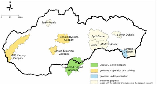
Figure 1.
Map of geoparks in Slovakia [41,42].
2.3.1. Banská Štiavnica Geopark
The first geopark that was established in Slovakia is located in the historical town of Banská Štiavnica and its surroundings, covering most of the area of the Štiavnické Vrchy Mountains. Thanks to the rich geological history closely associated with Neogene volcanic activity [43,44] and the influence of mining activity and mining, the area of Banská Štiavnica has become a unique place not only in Slovakia but also the world. Thanks to the mineral wealth and the development of mining, the Bergakademie—the first technical university in the world—was established here in 1786 based on a decree of Maria Theresa. Considering the values offered by the town of Banská Štiavnica, located in the vicinity of technical monuments, it has been added to the UNESCO World Heritage List, specifically as a cultural heritage site. The mentioned values were the impetus for the establishment of the Banská Štiavnica Geopark [45,46,47].
According to the Site Passport [48], we can find 156 sites in the geopark. Of these, 82 are mining sites with the largest representation, followed by cultural and historical sites with 34, and montanistic and recreational sites with 17. Then, we can find nine montanistic and geological sites, seven natural sites, three geological and natural sites, and one site each in the montanistic and archaeological, geological and archaeological, geological, cultural–historical, and archaeological domains. Konečný and Pachinger [49] describe 103 geosites in the territory of the geopark. Within the territory of the Banská Štiavnica Geopark, there are two information centres, one located directly in Banská Štiavnica and the other in Štiavnické Bane. However, the availability of information centres does not necessarily mean that they are geopark-oriented and provide information about the geopark.
The most important heritage sites of this geopark include Old All Saints Mine, tajchs, and an open-air museum. The significant importance of the Old All Saints Mine site is evidenced by its more than 700 years of mining history. Currently, the mine offers the opportunity to discover the mining environment, whether in the form of an underground space, hammer excavation, or an exhibition with more than 3500 mineral samples.
The existence of tajchs in the vicinity of Banská Štiavnica contributed to the inclusion of this town in the UNESCO World Heritage List. Tajch Klinger is one of the most important locations in the geopark. To this day, it has educational, cultural, and recreational value.
The open-air museum in Banská Štiavnica is one of the most important locations in the Banská Štiavnica Geopark from the visitor’s perspective, providing a unique experience in mining areas. It represents the oldest and most extensive mining exhibition in Slovakia. It also includes the Bartolomej adit, a horse-powered Gápel, and a water-column towing machine.
2.3.2. Banská Bystrica Geopark
The primary impetus for the establishment of the Banská Bystrica Geopark was the presence and possibility of using many geosites, mining heritage sites, and unique ecological phenomena, as well as cultural and historical monuments located in the territory of Banská Bystrica City and its surroundings [45]. The most significant of them include a unique historic water pipeline built in the 16th century, Harmanecká Cave with a high abundance of moonmilk, as well as a large number of wintering bats, Ľubietová Village, and Ľupča Castle.
The historic water pipeline in Špania dolina is a unique technical work that has been flowing for almost 400 years and powered, for example, towing machines. In its era, it was one of the most important elements in the development of mining and metallurgy in Banská Bystrica Town.
The village of Ľubietová is considered an area of European importance and is characterised as a geological, mineralogical, natural, archaeological, montanistic, and historical site. It was once a royal mining town from which we can find remains.
The national cultural monument Ľupča Castle, the first mention of which is older than 650 years, is one of the best-preserved castles in Slovakia. The complex includes the upper Gothic castle, the lower Renaissance castle, Gizela’s house, and a well ending in a tunnel.
The plan for establishing the geopark was implemented within the framework of partnerships created between local and regional institutions, educational professional bodies, and private-sector representatives [45,47]. According to the Locality Passport [50], there are a total of 292 sites in the territory of the geopark. In the case of this geopark, the largest representation of cultural and historical sites is as many as 81. The geopark has 55 geological and montanistic sites, 47 exclusively geological sites, 43 geological and natural sites, 34 sites related to historical mining, and 6 archaeological sites.
2.3.3. Novohrad-Nógrád UNESCO Global Geopark
The only UNESCO Global Geopark (UGGp) which is partly located in Slovakia is the cross-border Novohrad-Nógrád UGGp. The Slovak part of the geopark covers one-third of the geopark’s territory [51,52]. Only the Slovak part of this geopark was considered for an objective assessment of information about heritage and its presentation in Slovak geoparks.
A total of 53 sites are located on the Slovak side of the geopark [53]. The most frequent type of locality is geological, with 15 sites. In addition to these sites, the geopark also encounters eleven cultural–historical sites, nine geological and montanistic sites, six geological and natural sites, three purely montanistic sites, three archaeological sites, two natural sites, two geological and archaeological sites, one relaxation and geological site, and one natural and cultural–historical site. The tourist information centre of the Novohrad Geopark is located in the town of Fiľakovo [54]. The most important sites in this geopark include the stone waterfall Šomoška with its castle, the Čakanovce profile, the Sandstones of Lipovany, and the Mučín Cave.
The importance of connecting geological and cultural heritage within the site of Šomoška is evidenced by the fact that the stone waterfall and the castle are depicted on the official logo of the Novohrad-Nógrád UGGp. They are supposed to symbolise the unlimited borders and scope—the boundlessness of the geopark.
The Čakanovce Profile i a natural monument presenting an important geological profile of the sediments of the Lower Miocene Sea. River sediments, as well as terrestrial lake sediments, can be found at the site. Traces of later volcanic activity are also visible [55].
The Sandstones of Lipovany site is a scientifically significant geological profile with grey and brown sandstones and fossils visible [55]. This site, the so-called ‘Sandpit’, is an important educational geological and fossil site within the Novohrad-Nógrád UGGp.
Mučin Cave is not a ’classical’ cave. It was formed by the erosion of a charred tree trunk [56].
2.3.4. Malé Karpaty Geopark
The youngest member that has been included in the National Network of Geoparks in Slovakia is the Malé Karpaty Geopark. It is divided into six geomontane areas. The geopark has many prominent areas in the field of mining and geology, which prompted the establishment of this geopark. The geopark does not have a published passport of sites, so the total number of geopark sites is unavailable. However, according to the Project Plan of the geopark [57], the estimated number of sites is 102. The most important sites promoted by the geopark include natural and montanistic sites such as the Ferninad adit, the Mining and Natural Open-Air Museum, and the Geological Museum, as well as the important geological site, Sandberg, which has more than 250 species of fossils [58].
2.4. Methods
Three consecutive phases were implemented for the research (Figure 2). The first phase involved collecting relevant publications for the primary purpose of processing a theoretical analysis of the topic. The content of the resources is represented by professional books and publications in the form of scientific articles. However, relevant internet sources were also taken into account.
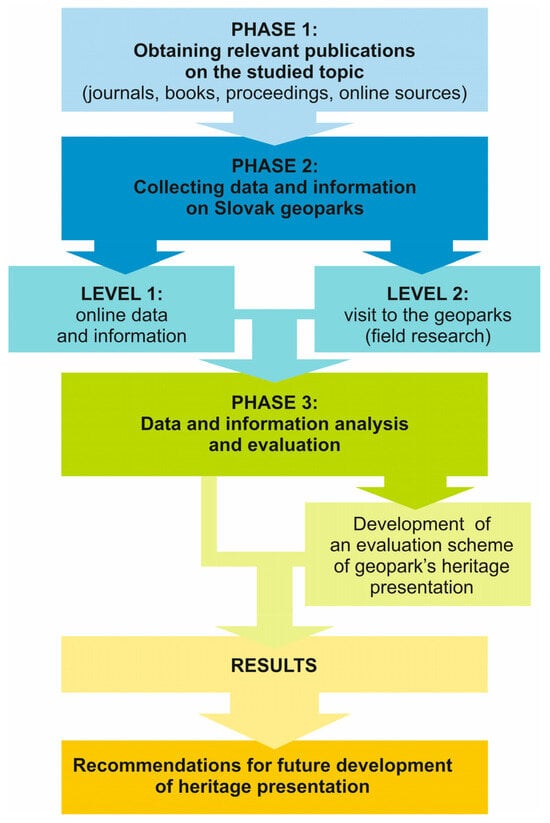
Figure 2.
Flowchart of the research.
In the second phase, relevant data on the four Slovak geoparks were collected. This phase was realised on two levels. On the first level, information was drawn from online sources, including the official website of the Slovak geoparks (https://www.geopark.sk/, accessed on 4 September 2024) the official website of each geopark, and the geoparks’ social media platforms. The second level consisted of data collection based on physical visits to individual geoparks. These visits, which took place during the second half of 2023 and in spring 2024, also included interactions with geopark staff, e.g., in the tourist information centres, to find out the current situation. The visits allowed us to obtain information and data from the territory of geoparks and their specific (most attractive) locations, information boards installed at sites, or educational trails, for further analysis. Sites visited in individual geoparks were selected to cover the geological, cultural, and historical aspects of the geopark’s heritage.
The last phase consisted of a detailed analysis of the data obtained from the previous two phases. In addition to the basic facts about geoparks, the detailed analysis focused on the methods of heritage presentation in each Slovak geopark. After a separate analysis of all geoparks, a comparison and evaluation were performed based on the results of the analysis results.
The proposed assessment method, defined based on previously published studies on a similar topic [59,60,61,62], utilises a six-point scoring system (0–5) to evaluate the quality and effectiveness of online and onsite geopark heritage information and its presentation in nine categories based on the key given in Table 1, covering the following four aspects:

Table 1.
Assessment methodology for the online and onsite heritage information and presentation in geoparks.
- Content quality: accuracy, completeness, depth, and relevance of information;
- Presentation quality: clarity, readability, visual appeal, and user-friendliness;
- Accessibility: availability in different languages, accessibility for people with disabilities, and/or different visitor groups;
- Innovation: use of interactive elements, multimedia, and innovative presentation techniques.
3. Results
The first option through which potential visitors of geoparks can engage with the information is the official national website, which contains information about Slovak geoparks (geopark.sk). Using a local version of the Google search engine, this website will appear as the first suggestion in any browser after entering terms such as ‘geoparks in Slovakia’, ‘Slovak geoparks’, and ‘geopark’. The website ‘geopark.sk’ provides basic information about geoparks and external links to other individual geoparks, except for the Banská Štiavnica Geopark, as it does not have an official website. However, this website does not provide any relevant information about the natural or cultural heritage of Slovak geoparks. A potential visitor cannot find information about specific locations in the geoparks themselves. In the section ‘Promotion and Edification‘, a few sites are described in brochures but these are not distributed evenly for each geopark [63]. However, most available documents are only in Slovak (Figure 3), making them relatively inaccessible to international visitors. The Slovak version of the website includes 55 accessible documents (e.g., brochures, maps), the English version includes 11 documents, and the German version only includes 6. Some of the information presented on the site is outdated and several years old. Much of the information about Slovak geoparks is incomplete; it is written, in general, without much detail or written using professional terminology and without informative value for the general public. In terms of reports in the media, through which Slovak geoparks could be shown in more detail and promoted, we could not find any examples.
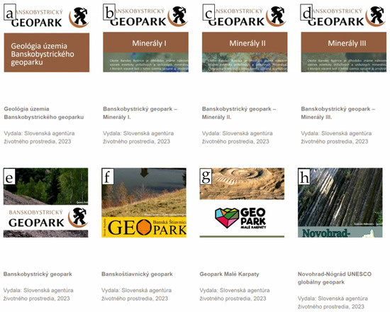
Figure 3.
Examples of available information materials in Slovak language downloadable from the website geopark.sk (www.geopark.sk), (a) Geology of the Banská Bystrica Geopark, (b) Banská Bystrica Geopark—Minerals I, (c) Banská Bystrica Geopark—Minerals II, (d) Banská Bystrica Geopark—Minerals III, (e) Banská Bystrica Geopark, (f) Banská Štiavnica Geopark, (g) Malé Karpaty Geopark, (h) Novohrad-Nógrád UNESCO Global Geopark (all materials issued by the Slovak Environment Agency) [63].
3.1. Banská Štiavnica Geopark
Potential visitors of Banská Štiavnica Geopark cannot easily obtain even basic information about the geopark. Brief information is published on the Slovak Geoparks Network (SGN) website, but since the Banská Štiavnica Geopark does not have an official website, even the most minimal information is not publicly available without a detailed search. Similar findings were discussed by Palgutová et al. [64]. Also, social network accounts are not managed. The contact listed on the SGN web is ‘Region Sitno’. Using the Google search engine, the first search result links to a relatively complex online multimedia geotourism guide for the area of Banská Štiavnica and its surroundings (regionsitno.sk) which is available in the Slovak language only. However, one needs to be aware of specific information about what to search to find the site. For an unaware person, Region Sinto does not refer to Banská Štiavnica Geopark at all.
The same is true for the geopark’s territory itself. Field research in this geopark covers the following sites in the city of Banská Štiavnica: Old Castle, Klopačka, Piarg Gate, New Castle, Glazenberg educational trail, and the Open-Air Mining Museum. It also includes sites from Hodruša-Hámre: Hodrušské jazero lake, Zlatý stôl adit (‘Golden Table Adit’), Baňa Starovšechsvätých Mine (‘Old All Saints Mine’), and mining and geological exposition site. In most cases, information panels and maps do not have the logo or name of the Banská Štiavnica Geopark (Figure 4 and Figure 5). A comprehensive map of the area with marked locations that are part of the geopark is not available anywhere. Moreover, the onsite heritage presentation provided by the geopark is minimal. Although the tourist information centre is active, it does not promote the geopark or its geosites, mining history, or cultural monuments. Even though this geopark was the first geopark established in Slovakia, there is almost no awareness of its functioning or presentation among the public. Based on this, it can be stated that the Banská Štiavnica Geopark does not use its full undeniable potential. In most cases, information about the sites is presented at least by information panels or basic leaflets or brochures, but without any connection or reference to the geopark in most cases. The Banská Štiavnica Geopark minimally interprets its heritage. In principle, it can be stated that this geopark exists ‘only on paper’, and its real operation is more than questionable. As such, these findings indicate that the visitor has very limited or no knowledge that they are in the territory of the geopark.
Figure 4.
Information panel with a map of important sites with no reference to the geopark (photo by Kristína Pramuková).
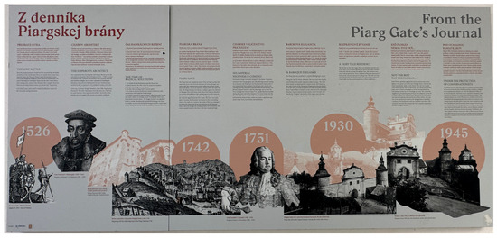
Figure 5.
Educational board at the Piarg Gate cultural monument with no reference to the geopark (photo by Kristína Pramuková).
3.2. Banská Bystrica Geopark
The Banská Bystrica Geopark has an official website (https://www.geoparkbb.sk/, accessed on 4 September 2024) with basic information about the geopark, tourist information centres, educational trails, and basic descriptions of its geological, mining, and cultural heritage. Unfortunately, the full version of the website is only available in Slovak. The English version of the website includes very limited information, so potential foreign visitors cannot obtain proper information about the geopark’s heritage. The only option is an automatic translation tool, which may provide incorrect information. The website also lacks a complete list of locations within the geopark and detailed information about these areas. The map does not indicate all the locations, making it difficult for visitors to navigate. While there are some videos of the locations, news about events, seminars, and workshops is outdated.
The geopark attempts to interpret natural and cultural heritage through the social network Facebook. While the geopark account regularly posts about workshops and exhibitions, it does not use any other platform like Instagram, X, or TikTok, which could reach a wider audience. The promotional materials, such as brochures and leaflets, are unavailable online on the official website. Many available materials related to this geopark use technical or scientific language that is difficult for the general public to understand. The materials also lack QR codes for quick access to additional information.
For the purpose of this study, the following locations were visited in the Banská Bystrica Geopark: in Ľubietová, the minigeopark, Ľubietová educational trail, and Ľubor Mining Tower; in Slovenská Ľupča, the tourist information centre, Ľupča Castle, and Ľupča Rock Mushroom; in Špania dolina, Maximilián heap, Ferdinand Shaft, Klopačka, the Church of the Transfiguration of Our Lord, St. John’s Chapel, the Mining Astronomical Clock, and the Barbora Route; and in Banská Bystrica, the tourist information centre and Barbakan Town Castle. Field research revealed that the geopark has limited information panels and maps. Some locations are not marked, and others have information boards that do not mention the geopark. Although they present and interpret the geopark’s heritage, the educational trails do not mention the geopark itself. Similarly, there is a lack of guided tour services provided by the geopark staff or under the geopark’s umbrella. So, visitors must rely on various websites to find information about guided tours.
In general, Banská Bystrica Geopark lacks a cohesive identity. The information boards, maps, and educational trails seem to be managed by other entities (Figure 6) and not by the geopark. Visitors can only find a comprehensive list of geopark sites on the website of the State Geological Institute of Dionyz Štúr within a special section of educational geology digital maps [65] (available at: https://app.geology.sk/bbgparkg/, accessed on 4 September 2024). However, this site is unknown to the general public. Onsite visits revealed that tourist information centres also lack information about the geopark.
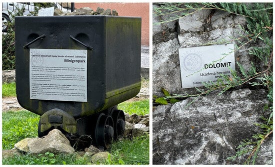
Figure 6.
Examples of exposition in the minigeopark in Ľubietová with no reference to the Banská Bystrica Geopark (photo by Kristína Pramuková).
3.3. Novohrad-Nógrád UNESCO Global Geopark
Novohrad-Nógrád UNESCO Global Geopark uses all of the basic ways to present the geopark itself, its heritage, and the values it represents. The official website of the geopark (https://www.nogradgeopark.eu/en, accessed on 5 September 2024) provides a good general overview. However, there are a few broken links, and some information remains in Hungarian on both the Slovak and English versions. The website presents only the main information about the geopark, heritage, and sites without the possibility of obtaining more detailed information or determining the mutual interconnections or relationships of various heritage types. The presentation of natural and cultural heritage is connected to an interactive map, where the visitor can choose a specific site they are interested in and, after clicking on the location, is redirected to facts about it. However, information about sites, especially in the case of natural heritage, is provided in professional jargon, and the lay public may not understand it. We did not find any promotional videos or entertaining and educational elements interpreting the geopark and its heritage on the website.
The geopark has social media accounts on four platforms. However, it does not use these platforms’ potential for presenting natural and cultural heritage. The Facebook page is the most used, but only reshared posts by someone else are usually added. Other social networks are hardly used at all, even though, for example, videos posted on TikTok have been relatively successful, as evidenced by the reach of the videos as well as the audience engagement through comments under the videos.
A mobile app is also available. However, since it is not exclusively dedicated to the geopark, it is necessary to know its specific name (Bukk Nemzeti Park Igazgatosag) or the abbreviation (BNPI park) through which this application is searchable. Similarly to the website, the application also contains the same professional description of the sites, which can be difficult for the general public to understand. At the same time, we did not find any information other than that published on the website. Although the application does not bring any new information compared to the official website of the geopark, its active use can help visitors to understand and learn about the heritage of the geopark effectively. Its existence must, therefore, be perceived positively.
In the Slovak part of the geopark territory, visitors have access to a wide range of materials presenting natural and cultural heritage, from introductory leaflets, maps, and brochures to paper guides and publications. However, as with the website, in the case of promotional material related to the description of sites, technical terms are used in many cases, which can be more difficult to understand or may even discourage visitors from studying such materials.
We conducted onsite visits in the Slovak part of the Novohrad-Nógrád UNESCO Global Geopark at the following locations: Šomoška educational trail, the Profile of Čakanovce, Fiľakovo City, Čamovce quarry, Owl Castle in Šurice, and Hajnáčka (castle hill). The characteristics of individual sites are mostly supplemented by an information board and, for larger areas, also by a map. However, we can find localities for which almost no information is available (Figure 7), as they are not marked on the map or do not even have an information panel (Figure 8). Many information boards are usually part of educational trails, which tourists often learn about on the spot. However, some locations are difficult to find, and there is a possibility that they cannot be accessed at all. In this case, the application mentioned above is useful, especially when the user has stable signal coverage.
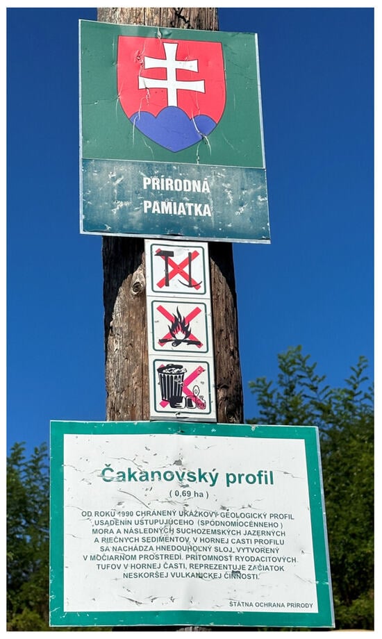
Figure 7.
Information panel at the important geological site and nature monument, the Čakanovce Profile (Čakanovský profil) (photo by Kristína Pramuková).
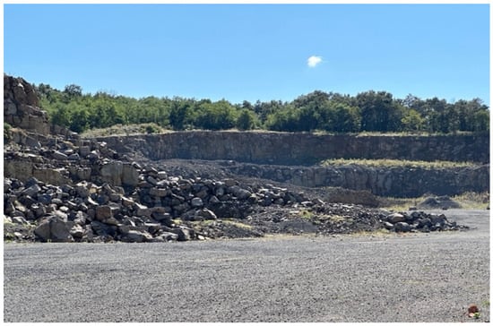
Figure 8.
Stone quarry located in Čamovce in the area of Novohrad-Nógrád UGGp with no information or designation (photo by Kristína Pramuková).
Overall, the presentation of natural and cultural heritage is not well balanced, and it is not implemented in such a way as to attract visitors, motivate them to visit for a longer time, or attract their attention. The geopark has various promotional materials and information boards and, to a lesser extent, uses various online channels to present the geopark and its heritage. But it seems that there is no recent activity aimed at developing it further. Many times, tourists who come to see a certain location do not even know that they are in the territory of a geopark. In this regard, awareness of the geopark and its heritage is not as high as expected for a UNESCO Global Geopark.
3.4. Malé Karpaty Geopark
The official website of the Malé Karpaty Geopark (https://geoparkmalekarpaty.sk/, accessed on 9 September 2024) is up to date, events to be held in the future are still being added, and some projects are underway. The geopark organises educational programmes, workshops, and teambuilding activities. The territory of the geopark is represented by videos and sound exhibitions that tell a story and may also attract children. A significant limitation is the lack of language versions other than Slovak for the website, forcing foreign visitors to rely on automated translation tools. We also could not find any information about all the locations that are part of the geopark and where they are located. It seems the geopark website only draws attention to the most important sites. There is also no information about the tourist information centre, and promotional materials are not available in an online form. Overall, despite the mentioned shortcomings, it can be stated that the geopark pays attention to the website and its content and tries to present what the geopark has to offer. The same applies to social networks, where the Malé Karpaty Geopark presents upcoming events in the geopark and its territory, as well as educational and promotional material, through its Facebook page. The geopark has no active account on any other social network. In this regard, creating accounts on other platforms, e.g., Instagram, which is currently widely used to add short videos to reach the largest possible audience, should significantly contribute to awareness of the geopark, its heritage, and geopark’s offer.
Malé Karpaty Geopark has also directed its attention to creating promotional materials. Simple leaflets with general information about the geopark are available in four languages. However, brochures specifically focused, for example, on geology are unfortunately provided only in Slovak. Educational materials, which also introduces the heritage of the geopark, have also been made for children to bring them closer to the geopark in a playful way. A negative element within the promotional materials is that there is no material focused solely on the geopark sites. Therefore, it is not possible to identify how many and which sites are located in the geopark either through the website or the promotional material. From the perspective of foreign visitors, there is also a lack of presentation or information materials in foreign languages.
The website and social networks provide an overview of educational activities. Several educational programmes are available, and an individual approach is also possible by appointment. The programmes are designed for all ages. The problem arises when trying to obtain information about the geopark in the tourist information centre, as there is no information about which TIC falls under the Malé Karpaty Geopark or with which TIC the geopark actively cooperates. After looking at the individual websites of the tourist information centres and contacting them, no connection with the geopark was found.
Sites visited during the field research in the area of Malé Karpaty Geopark include the mining educational trail in Pezinok, the Budúcnosť Open-Air Museum (including a visit to the Budúcnosť adit), Svätý Jur (city and vineyards), Sandberg, Devínska Kobyla, Devín Castle and castle hill, Bratislava Castle and castle hill, the black shale adit in Marianka, and the shale quarry in Marianka. There is also a problem with information boards and maps in the presentation of natural and cultural heritage in a language other than Slovak, as, for example, in the case of panels installed in the Budúcnosť Open-Air Museum (Figure 8). In addition, the sites and their heritage are described using educational panels. Some have added interactive elements such as working QR codes or rock samples. Fossil models have been installed in the Dubová locality, which can be considered a unique element within all four analysed areas of Slovak geoparks. At the site of the Budúcnosť Nature and Mining Open-Air Museum, several information panels are installed, which inform in a relatively comprehensive way about the heritage of the geopark (Figure 9). From the geopark visitor’s perspective, it may be somewhat confusing that some information panels at some sites contain the name of the non-existent Sandberg-Pajštún Geopark (Figure 10). These are the original information boards installed at the beginning of activities related to the effort to establish a geopark and the development of geotourism in this area. To this day, they have not been updated.
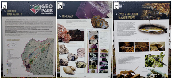
Figure 9.
Examples of information panels from the locality of the Budúcnosť Open-Air Museum, (a) Geopark Malé Karpaty, (b) Minerals, (c) Life in creeks of Malé Karpaty Mountains (photo by Ľubomír Štrba).
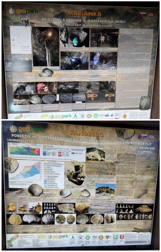
Figure 10.
Information panels from the Marianka and Sandberg sites referring to the non-existent Sandberg-Pajštún Geopark (photo by Ľubomír Štrba).
3.5. Assessment Results and Comparison of Geoparks
Table 2 and Table 3 compare the presentation of heritage in individual Slovak geoparks. Table 2 summarises the online availability of promotional and educational materials. Comparison results show that all geoparks have their promotional material available online. However, it is surprising that these materials are not accessible via the geoparks’ websites but only via the Geoparks Network of the Slovak Republic’s website.
Table 2.
Comparison of the availability of information and presentation of heritage in Slovak geoparks.
Table 3.
Evaluation of the presentation of heritage in individual Slovak geoparks.
Score values in Table 2 were assigned according to the analysis results. Several factors were taken into account, such as the availability of information, foreign language translations, the amount and content of promotional material, the content of information boards, expertise, or the scope of guide services and services provided in the TIC. The total number of points that could be obtained was 45, with higher scores indicating a better heritage presentation.
Table 3 and Figure 11 show that the Banská Štiavnica Geopark received the fewest points, only 7, followed by the Banská Bystrica Geopark with 14 points. The best overall score in terms of providing information and presenting the geopark’s heritage was achieved by the Malé Karpaty Geopark. However, it still has some considerable shortcomings. Interestingly, the Novohrad-Nógrád UNESCO Global Geopark did not take first place in the evaluation, even though it is included in the UNESCO Global Geoparks Network. Such a result clearly shows that even the membership of a geopark in the global network does not automatically mean that the geopark presents its heritage in the best possible way on its territory, as some may expect.
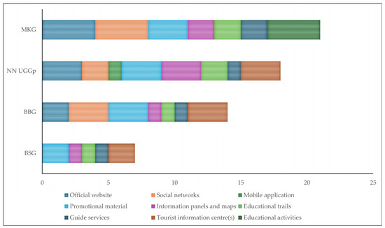
Figure 11.
Results of the evaluation of the presentation of heritage in Slovak geoparks.
Evaluation results indicate that Malé Karpaty Geopark has a relatively comprehensive and well-developed approach to heritage information presentation. With moderate scores, Novohrad-Nógrád UNESCO Global Geopark and Banská Bystrica Geopark have a moderate level of development in their current heritage presentation activities. Banská Štiavnica Geopark’s lowest score reveals significant space for improvement in its online presence, social media engagement, and overall heritage communication strategies.
Considering the online presence of Slovak geoparks, Malé Karpaty Geopark reaches high scores in the categories ‘official website’ and ‘social networks’, suggesting a comprehensive and well-maintained website with various kinds of information and interactive elements and an active social media account. The absence of an official website, as in the case of the Banská Štiavnica Geopark, significantly impacts its online visibility and ability to reach potential visitors. The social media accounts of Banská Bystrica Geopark and Novohrad-Nógrád UNESCO Global Geopark demonstrate a relatively good presence, with active accounts and some audience engagement.
Regarding the onsite heritage presentation, Novohrad-Nógrád UNESCO Global Geopark’s score of 3 shows the best performance among the Slovak geoparks, indicating it has well-placed and informative panels and maps. Male Karpaty Geopark and Novohrad-Nógrád UNESCO Global Geopark have relatively well-developed educational trails, while the other two geoparks have room for improvement in trail maintenance, presentation, and accessibility. The results also revealed that Malé Karpaty Geopark offers a broader range of guide services, which might be related to a higher level of experience and professionalism in this area.
All geoparks have some level of promotional material, but the quality and comprehensiveness vary. While Malé Karpaty Geopark stands out in terms of educational activities, offering a diverse range of programmes for different age groups, it lacks a tourist information centre unlike other Slovak geoparks.
Based on the analysis, a key strength across all Slovak geoparks is the existence of promotional materials. This traditional approach effectively disseminates information and attracts visitors. Individual Slovak geoparks demonstrate specific strengths:
- Relatively strong online presence of Malé Karpaty Geopark.
- Active social media use of the majority of Slovak geoparks.
- Good onsite use of information panels and maps, providing visitors with relatively straightforward and informative guidance in the Novohrad-Nógrád UNESCO Global Geopark.
- Well-developed educational trails and a variety of guided tours in the Novohrad-Nógrád UNESCO Global Geopark and Malé Karpaty Geopark.
The most significant weaknesses in the online and onsite heritage information and its presentation in Slovak Geoparks include the following:
- Most online and onsite information is primarily available in Slovak, hindering accessibility for international visitors.
- The absence of mobile applications for most geoparks significantly limits accessibility and the ability to provide interactive or location-based experiences.
- Most Slovak geoparks offer limited educational activities and guide services for visitors. This presents a missed opportunity to engage audiences and contribute to a deeper understanding and appreciation of the natural and cultural heritage located in the geopark’s territory.
- Lack of modern interactive elements and digital storytelling using virtual reality, augmented reality, digital timelines, or 360-degree videos.
These findings suggest a need for significant improvement in the educational activities, guide services, and digital and interactive aspects of heritage presentation in Slovak geoparks to enhance visitor experiences, attract a wider audience, and effectively communicate the unique value of these areas.
4. Discussion
Field research revealed that the general awareness of geoparks in Slovakia is very low. In many cases, although a certain site is located in the territory of a geopark, it is not marked in such a way that it is unambiguous that it is a geopark. Overall, the availability of information is not consistent across all geopark sites. Some locations have detailed descriptions, often using professional terminology that may be difficult for the general public to understand. Other locations lack basic information or any indication that they are part of a geopark. Currently, most Slovak geoparks primarily focus on the domestic market, with limited information available for potential international visitors. The presentation of natural and cultural heritage varies significantly between different Slovak geoparks. The results obtained in the detailed analysis showed that the Malé Karpaty Geopark makes a relatively strong effort to present its heritage, although its focus on international visitors is currently limited. The Banská Štiavnica Geopark has limited heritage presentation, which may give the impression that it is not fully operational as a geopark.
Through a detailed analysis, several issues were identified and pointed out, which, to a certain extent, also affect the overall awareness about geoparks in Slovakia. The most important issues from the visitor’s perspective, as discussed below, include a website, mobile application, information and interpretable materials (including panels), and cooperation.
4.1. Website
The websites of Slovak geoparks lack several key aspects. To enhance the overall visitor experience, it would be beneficial to publish predesigned hiking trails and itineraries. For those discovering a geopark for the first time, a prepared itinerary with a specific theme and duration could be very helpful. If visitors are unsure of their goals or what to focus on, such suggested trips with designated stops could provide clear guidance. These itineraries could be categorised by theme (e.g., geology, nature, culture) and duration. They could represent one-day trips, excursions, or multi-day tours with recommended accommodation and dining options. This would help potential visitors navigate the park more easily, allowing them to choose a theme that interests them and learn more about it.
In addition to easy navigation and accessible information, the website should provide all necessary details without requiring visitors to search for them elsewhere. This means that the geopark’s website should allow visitors to view accommodation and dining options within the geopark, with the possibility of direct booking. Accessibility is one of the most important factors influencing visitation. Therefore, in addition to accommodation and dining options, it is advisable to include information on how to reach the area and individual locations. It is also useful to mention parking availability and focus on public transport accessibility. If locations or a target area are further from the nearest parking lot or public transport stop, it is necessary to provide detailed route descriptions to those places.
The Bohemian Paradise UNESCO Global Geopark utilises a fraction of the proposed suggestions. Through its official website, visitors can find tips for trips within the geopark (Figure 12), including duration and detailed descriptions of the included sites. The trips vary depending on activity preference, such as hiking trails, educational paths, or cycling routes [66]. Another UNESCO Global Geopark, the Bergstrasse-Odenwald Geo-Naturpark (Germany), offers hiking tips on its website, as well as various suggested hiking routes according to length and focus, and several routes that can be completed by bicycle [67].
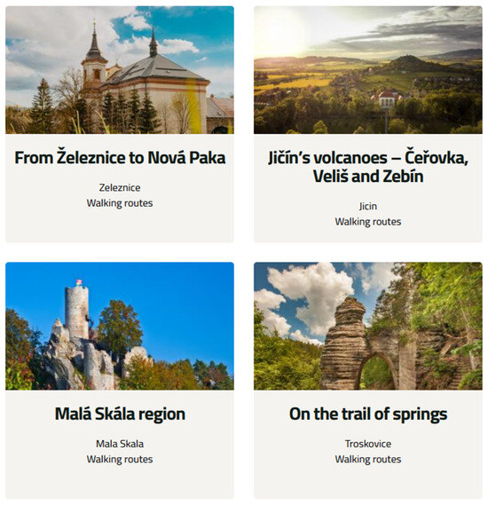
Figure 12.
An example of the implemented itinerary method from the website of the Bohemian Paradise UNESCO Global Geopark [66].
Further enhancement of the visitor experience could be achieved by developing an interactive map encompassing geopark locations, tourist information centres, educational trails, accommodation, restaurants, galleries, museums, exhibitions, and attractions. Visitors could filter the map based on their interests, such as a specific location, and view nearby points of interest. Additionally, they could create a customised visit to the geopark based on their preferred themes and goals.
To make the geopark more accessible to everyone, the map should include filters for different visitor needs. For example, filters could indicate whether locations suit children or if the visit involves cycling or hiking options. The map should also allow users to select their mode of transportation, such as car, public transport, or organised tours. In practice, this means that a potential visitor could input a desire to visit ten different types of locations and spend two days in the geopark with children. The map would then suggest suitable locations, considering family-friendly options, and provide alternatives for further exploration. It also suggests a visiting order, nearby accommodations, and dining options, complemented by additional attractions such as outdoor exhibitions or museums. This would eliminate the need for visitors to plan their itinerary independently. Of course, the map would merely serve as a guide, with the final decisions being made by the visitor.
The Psiloritis UNESCO Global Geopark in Greece and North Pennines AONB UNESCO Global Geopark in Great Britain have successfully implemented a similar approach. Their websites feature an interactive geopark map (Figure 13), including geological sites, activities, cultural heritage, and tourist information centres [68,69]. This serves as a real-life testament to the effectiveness of the proposed features, providing a tangible example for the reader and instilling confidence in the proposed approach.
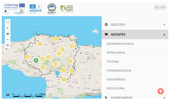
Figure 13.
Interactive map from the website of the Psiloritis UNESCO Global Geopark [68].
Virtual tours present an exciting and attractive way to interpret natural or cultural heritage. Imagine the thrill of exploring specific locations or landmarks, such as parts of a castle for cultural heritage sites or underground mine sections for mining heritage. The same approach can be applied to natural sites, presenting the area and its surroundings. Virtual tours can also be implemented on educational trails. This method is highly effective for promoting an area and providing visitors with an engaging way to explore a location.
Drone photography can be incorporated to enhance natural and cultural heritage presentation. This offers visitors a broader perspective of the area. To illustrate the effectiveness of this method, we can refer to the Lesvos UNESCO Global Geopark in Greece, which offers 3D models and animations on its website to showcase the geopark’s territory and geological sites [70]. A similar tool for heritage presentation can be found on the website of the Langkawi UNESCO Global Geopark (Malaysia), which offers a 360-degree virtual tour of the geopark (Figure 14) [71]. Another example is the Copper Coast UNESCO Global Geopark (Ireland) website, where a 3D tour is available [72].
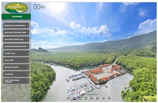
Figure 14.
Virtual reality on the website of the Langkawi UNESCO Global Geopark [71].
Offering products for sale on the geopark’s website through an e-shop would be beneficial to support the economic development of Slovak geoparks while showcasing the region. This could include local handicraft products or rocks, minerals, fossils, and publications.
4.2. Social Networks
Photos and videos posted on social media should be branded with the geopark logo. This means adding the geopark logo to each image or video. It is recommended to place the logo in a corner so as not to obscure the content but to ensure that it is still clearly visible, allowing viewers to identify the geopark. This also protects the content if someone takes and uses the image or video without permission. It creates a cohesive visual identity and makes it easy to identify the location.
To foster engagement with the audience, involving the public directly in social media activities is effective. This can be achieved by sharing and tagging their photos and videos taken within the geopark. Involving the public in social media activities increases the likelihood that their friends will see the content through their social networks and raises awareness of the geopark. It also creates a sense of community and belonging among the visitors. This strategy is particularly effective among younger generations, who are more likely to participate in contests. Creating contests, which are particularly popular among younger generations, can also be beneficial. Prizes could include geopark products, such as fossils, rocks, or a guided tour. Active engagement with the audience can positively contribute to the development of the geopark.
The impact of social media on the overall destination image of the Ciletuh-Palabuhantaru UNESCO Global Geopark, as demonstrated by the work of Mauladi et al. [73], is a testament to the power of digital marketing. Social media plays a significant role in decision-making and creating interest in visiting a geopark. This underlines the importance of our social media strategy in promoting the geopark and actively engaging with the audience. It is not just a tool for sharing content but a powerful means of shaping the perception of the geopark and fostering a sense of community among its visitors. An example is the Cuilcagh Lakelands Geopark, which actively uses social media to present its heritage [74].
4.3. Mobile Application
The development of a mobile application presents another engaging method of heritage presentation. Currently, the Novohrad-Nógrád UNESCO Global Geopark, in cooperation with the Hungarian Bukk National Park, offers a mobile application. However, awareness of this app is low, and it contains incomplete information. The potential of a well-developed mobile application, whether independently for each geopark or as a collaboration between all geoparks, is vast. Under the auspices of the Slovak Geoparks Network, a single main application could be developed, allowing users to select a specific geopark with the option to switch to another easily. This application has the potential to revolutionise how visitors interact with the geopark.
The application should include a list of all locations within the geopark, along with descriptions, photos, and accessibility information. This should be indicated for locations with available virtual tours. The application should also include helpful links to the website, social media, contacts, and practical information like opening hours. It should also include a news section to inform users about upcoming events or developments in the geopark.
A key element of the mobile application is an interactive map, functioning similarly to the proposed web-based map. The interactive map provides easy orientation and a visual overview of the area. It should display individual locations, tourist information centres, museums, galleries, exhibitions, and attractions. Adding an option to ’learn more’ would be beneficial for each entity, linking to more detailed information. It should also offer the possibility of displaying nature trails and planning custom routes. The route planner would allow users to select locations of interest and suggest an optimal visiting order, provide the total route length and difficulty level, and recommend nearby attractions and services. It would also provide navigation within the entire geopark to locations and objects. In addition to offline map downloads, this option should also be available for individual location information.
The mobile application can serve as a comprehensive guide to the geopark, offering engaging and easy access to information and onsite orientation. To reach an international audience, the mobile application should be available in at least one foreign language. Examples of geoparks that have developed and successfully implemented the use of mobile applications to increase awareness include the Cliffs of Fundy UNESCO Global Geopark in Nova Scotia, the Magma UNESCO Global Geopark in Norway, and the Nisyros Geopark in Greece. While these mobile applications are not as developed as the proposed concept, they offer offline maps, useful links, information about individual geological sites, and photos [75,76,77,78].
4.4. Information Panels
To make information panels more engaging for visitors, in addition to basic information, it is beneficial to supplement them with interactive elements. The Malé Karpaty Geopark has implemented the creation of fossil casts in one location. This presentation and interpretation method can also be applied in other geoparks and at multiple locations. It does not have to be limited to fossils but can also include casts of fauna, flora, or mining tools. This represents an effective tool for creating a new attraction for visitors.
Another alternative is the creation of 3D models for better visual and interpretive understanding. In the field of cultural heritage, this could represent, for example, a vanished archaeological site or the original footprint of a cultural monument. Natural heritage could focus on 3D models of inaccessible parts of caves or other geomorphological features. In addition to being placed directly on or near information boards, 3D models can be displayed using QR codes on individual boards. Three-dimensional models can be dedicated to, for example, rocks and minerals found in the area or to representations of mines and tunnels. The Hong Kong UNESCO Global Geopark has supplemented information boards about rocks with 3D miniature models and models demonstrating cross-sections of various geological processes to facilitate understanding for visitors [79].
In areas where they are unavailable, guided tours can be replaced by interesting presentations and interpretations of the heritage via QR codes. After scanning, an audiovisual guide is played, explaining the specific location. This element offers an opportunity to create engaging storytelling for children, such as a fairy tale about the area or a local legend. Some information panels can be supplemented with sound elements like sound buttons. These can approximate various types of fauna or extinct animals like dinosaurs and mammoths. In addition to providing a different experiential presentation for visitors, people with visual impairments can access information about the location through audio guides or sound buttons. As part of a Waitaki Whitestone UNESCO Global Geopark grant project, QR codes were created that transport users into a 90 s history of the geopark [80]. A similar approach was introduced by the Central Catalonia UNESCO Global Geopark and Conca de Tremp–Montsec UNESCO Global Geopark (Spain), which supplemented the presentation of heritage with audiovisual panels [81,82].
4.5. Presentation of Natural and Cultural Heritage Focusing on Children
Given that geoparks should strive to introduce heritage to all age groups, including families with children, it is advisable to adapt activities and related presentations or interpretations accordingly. While a mobile application is suggested for older visitors, a mobile game could be created to engage children. The game could be a quiz, with questions based on information boards at various locations. A 3D model of a mineral or animal would appear upon answering questions correctly. After completing all stations and collecting 3D models, a small reward could be offered, such as colouring books or promotional materials at the tourist information centre or a discount on a product they can choose. This would encourage visitors to visit the tourist information centre and increase the likelihood of purchasing additional products. The mobile game would combine fun with education and interactively motivate visits to the geopark. A paper version of the game could also be provided, and it should be made available for download on the website. Visitors could print out the questions linked to the individual information boards. However, they would not be able to see the 3D models. They would still be eligible for the chosen reward at the tourist information centre.
Evidence of the effectiveness of this method can be found in the Terra Vita UNESCO Global Geopark in Germany, which introduced the mobile game ‘Lost Collection’. By completing various mini-games, players unlock different plants or animals [83]. The Central Catalonia UNESCO Global Geopark has developed an application that introduces the geopark territory through various quizzes, such as identifying rocks and natural features. In case of correct response to the questions, the visitor will receive a reward, for example, a virtual mineral [84].
A ‘kids’ geological park’ could be created at important geological sites. A geological park focused on children could offer activities such as gold panning, finding rocks in sand, uncovering fossils, a climbing wall with various relief features, an obstacle course made of stalagmite replicas, and a simulated cave for writing and drawing on the walls with chalk. A playground themed to the area could also be created, such as a wooden climbing frame shaped like a dinosaur or a slide shaped like a volcano. The children’s geological park would be complemented by plants typical of the area. A similar idea was partially successfully implemented in the Železné Hory Geopark in the Czech Republic, where an interactive visitor centre, including an exhibition for children, was built in 2015. It features, for example, a dinosaur skeleton that can be uncovered from the sand [85]. This idea was implemented on a larger scale in the English Riviera UNESCO Global Geopark, where a park called ‘Geoplay Park Paignton’ plays a key role in the entire geopark. The park was designed according to the area’s geological history, ranging from the Devonian period for toddlers to the Carboniferous period (junior zone) and the Quaternary period for teenagers [86].
Some promotional materials should be engaging and educational for children. Interpreting natural and cultural heritage can be achieved engagingly through riddles, matching pictures to descriptions, puzzles, jigsaw puzzles, colouring books, or crosswords. Creating a brochure presented in a playful, illustrated form is also advisable, primarily featuring photos of the location and area for better understanding. An example of this type of presentation can be found in the Famenne-Ardenne UNESCO Global Geopark in Belgium and the Swabian Alb UNESCO Global Geopark (Germany), which have developed educational games for children in the form of various riddles, colouring books, maps, and puzzles [87,88]. A similar solution was implemented in the Idrija UNESCO Global Geopark in Slovenia, where two fictional explorer characters were created to accompany children in the geopark, supplemented by educational promotional materials [89].
4.6. Cooperation
Strengthening partnerships could have a positive impact on the geopark itself. Incorporating accommodation and dining facilities into the website would facilitate visitors’ experience. Establishing partnerships between the geopark, accommodation, and dining facilities could result in mutual promotion and support. When visitors seek information about the geopark on its website, they are directly directed to relevant dining and accommodation facilities. The same would apply in the opposite case, where a visitor without information about the geopark would be referred to the geopark’s website or promotional materials by the accommodation or dining facility. This technique is applied, for example, by the Rokua UNESCO Global Geopark in Finland, which offers accommodation within the geopark directly through its official website with links to the websites and contacts for accommodation facilities [90]. We can also mention the Hong Kong UNESCO Global Geopark and the Burren and Cliffs of Moher UNESCO Global Geopark (Ireland), where, in addition to accommodation facilities, we can find dining establishments that thematically present geofood [91,92].
It would also be beneficial to establish partnerships with educational institutions, both universities and primary schools. Universities could conduct field trips within the geopark, while primary schools could use the geopark as an optimal destination for field trips and outdoor learning. This also applies to secondary schools, where the area can be used as an educational space, offering expert lectures or excursions. An example of the successful implementation of this method is the Villuercas-Ibores-Jara UNESCO Global Geopark in Spain, which created its own educational project called ‘Geo-Schools’, where the geopark is used as a central point. A total of 81 educational activities for primary and secondary schools have been organised in the geopark. On average, up to 2500 students use the opportunity to learn in the geopark annually [93]. Luberon UNESCO Global Geopark (France) also provides educational programmes for schools [94].
Similarly, UNESCO Global Geoparks in Portugal have introduced educational programmes following the Portuguese Ministry of Education standards. An educational programme called ‘GEA-Mother Earth’ was created to engage local schools, international schools, and all educational institutions, from kindergartens to universities [95].
To support the overall growth and development of the geopark, it is beneficial to establish cooperation with foreign geoparks, as this opens up opportunities for the exchange of knowledge in geopark management. For Slovak geoparks, this can be an opportunity to benefit in several areas, such as management, promotion, and the operation of the area itself. An example of this is the cooperation between the Lesvos UNESCO Global Geopark and the San’in Kaigan UNESCO Global Geopark, which, through shared values, mutually support local development and geotourism and preserve heritage for present and future generations [96]. To support the development of geotourism and sustainable economic and cultural tourism, the European Atlantic Geotourism Route was created, connecting nine European geoparks, two aspiring geoparks, and two universities. It connects the countries of Portugal, Ireland, Great Britain, and Spain [97]. Another example is the project ‘Danube Geotour Plus’, which is based on the cooperation of nine geoparks. The project aims to work together on the development of geoparks and sustainable tourism and the creation of valuable products for visitors [98].
5. Conclusions
The tourism industry is growing rapidly at present, despite the significant downturn caused by the COVID-19 pandemic. A considerable part of sustainable tourism territories can be made up of geoparks, which connect tourism, recreation, education, and nature conservation. In general, geoparks contribute to the development of tourism and sustainability. However, awareness of geoparks in Slovakia is mainly absent. In this paper, based on our analysis, several issues with the presentation of heritage from the visitor’s perspective in the territories of Slovak geoparks were pointed out. A multifaceted approach is imperative to elevate the standing and impact of Slovak geoparks. By prioritising digital innovation, effective heritage presentation, strategic partnerships, and sustainable practices, geoparks can significantly enhance the visitor experience and contribute to local economic and sustainable development.
A robust digital presence, encompassing user-friendly websites, interactive maps, and mobile applications, is crucial. These digital tools can provide comprehensive information, virtual tours, and personalised itineraries, enhancing visitor engagement. Engaging presentation and interpretation through interactive exhibits, audiovisual guides, and educational programmes can captivate visitors of all ages, fostering a deeper understanding and appreciation of the geopark’s heritage. Strategic partnerships with local businesses, schools, and other geoparks can facilitate resource sharing, joint initiatives, and mutual promotion. Prioritising sustainability, including eco-friendly operations and conservation efforts, is essential for the long-term viability of geoparks and their surrounding environments. By implementing these recommendations, Slovak geoparks can position themselves as competitive destinations, attracting visitors and contributing to the region’s economic and cultural prosperity.
The research presented in this paper provides a comprehensive inventory of the different online and onsite heritage information presentation methods currently employed in Slovak geoparks. This inventory can be used for future research and development. By identifying and analysing existing heritage presentations, more effective and engaging communication strategies can be developed to reach wider audiences and thus promote the values of heritage located in geoparks.
The methodological approach and findings presented in this paper can serve as a foundation for future studies devoted to the research of presentation methods, assessment of visitor experiences, and the impact of these methods on public understanding and appreciation of the geopark’s heritage. However, the following limitations of this study should be acknowledged:
- The research primarily focuses on the existence of information and its presentation, not its effectiveness or impact on visitors.
- Despite the relatively complex definition of the assessment scoring system within individual categories, some degree of subjectivity is still present. Different researchers may assign slightly different scores for the same category. Additionally, research focused on the importance of individual assessment categories may result in different results if weights are applied. However, this would require input from visitors, which was not the subject of this study.
- The results of this study reflect publicly available information and data collected during geopark visits. Thus, some aspects of heritage presentation within the geoparks might be overlooked and not taken into account.
Future research should focus on the quality and effectiveness of heritage presentation and interpretation. For this purpose, visitor studies (questionaries and interviews) are required to assess visitor perceptions of the existing presentation methods, their effectiveness in communicating and interpreting heritage values, and overall satisfaction with the visitor experience.
Author Contributions
Conceptualisation, K.P. and Ľ.Š.; methodology, Ľ.Š.; validation, K.P. and Ľ.Š.; formal analysis, K.P. and Ľ.Š.; investigation, K.P. and Ľ.Š.; resources, K.P. and Ľ.Š.; data curation, K.P. and Ľ.Š.; writing—original draft preparation, K.P.; writing—review and editing, Ľ.Š.; visualisation, Ľ.Š.; supervision, Ľ.Š.; project administration, K.P. and Ľ.Š.; funding acquisition, K.P. and Ľ.Š. All authors have read and agreed to the published version of the manuscript.
Funding
This research received no external funding.
Data Availability Statement
The data that support the findings of this study are available from the corresponding author upon reasonable request.
Conflicts of Interest
The authors declare no conflicts of interest.
References
- Dowling, R.; Newsome, D. Geotourism: The Tourism of Geology and Landscape; Goodfellow Publishers: Oxford, UK, 2010. [Google Scholar]
- Farsani, N.T. (Ed.) Geoparks and Geotourism: New Approaches to Sustainability for the 21st Century; BrownWalker Press: Boca Raton, FL, USA, 2012. [Google Scholar]
- Ólafsdóttir, R. Geotourism. Geosciences 2019, 9, 48. [Google Scholar] [CrossRef]
- Dowling, R.K. Geotourism’s Global Growth. Geoheritage 2010, 3, 1–13. [Google Scholar] [CrossRef]
- Štrba, Ľ.; Kolačkovská, J.; Kudelas, D.; Kršák, B.; Sidor, C. Geoheritage and Geotourism Contribution to Tourism Development in Protected Areas of Slovakia—Theoretical Considerations. Sustainability 2020, 12, 2979. [Google Scholar] [CrossRef]
- Štrba, Ľ.; Kršák, B.; Baláž, B.; Kolačkovská, J.; Lukáč, M.; Molokáč, M. Geoturizmus; Technická Univerzita v Košiciach—FBERG: Košice, Slovakia, 2021; 220p, ISBN 978-80-553-3822-8. [Google Scholar]
- Jones, C. History of Geoparks; Geological Society, London, Special Publications: London, UK, 2008; pp. 273–277. [Google Scholar] [CrossRef]
- UNESCO Global Geoparks. Available online: https://www.unesco.org/en/iggp/geoparks/about (accessed on 26 May 2024).
- Guerini, M.; Khoso, R.B.; Negri, A.; Mantovani, A.; Storta, E. Integrating Cultural Sites into the Sesia Val Grande UNESCO Global Geopark (North-West Italy): Methodologies for Monitoring and Enhancing Cultural Heritage. Heritage 2023, 6, 6132–6152. [Google Scholar] [CrossRef]
- Xu, K.; Wu, W. Geoparks and Geotourism in China: A Sustainable Approach to Geoheritage Conservation and Local Development—A Review. Land 2022, 11, 1493. [Google Scholar] [CrossRef]
- Dowling, R.K. Global Geoturism: An Emerging Form of Sustainable Tourism. Czech J. Tour. 2013, 2, 59–79. [Google Scholar]
- Khoshraftar, R. Geoparks: Research and Pedagogical Values. Available online: https://www.researchgate.net/publication/280231988_GeoparksResearch_and_Pedagogical_Values (accessed on 10 May 2024).
- Patzak, M.; Eder, W. “UNESCO GEOPARK” A new Programme—A new UNESCO label. Geol. Balc. 1998, 28, 33–35. [Google Scholar] [CrossRef]
- Pásková, M.; Zelenka, J.; Ogasawara, T.; Zavala, B.; Astete, I. The ABC Concept—Value Added to the Earth Heritage Interpretation? Geoheritage 2021, 13, 38. [Google Scholar] [CrossRef]
- Mansfeld, Y. From motivation to actual travel. Ann. Tour. Res. 1992, 19, 399–419. [Google Scholar] [CrossRef]
- Yoo, C.-K.; Yoon, D.; Park, E. Tourist motivation: An integral approach to destination choices. Tour. Rev. 2018, 73, 169–185. [Google Scholar] [CrossRef]
- Yousaf, A.; Amin, I.; Santos, J.A.C. Tourist’s motivations to travel: A theoretical perspective on the existing literature. Tour. Hosp. Manag. 2018, 24, 197–211. [Google Scholar] [CrossRef]
- Kim, M.S.; Baker, M.A. Sustainable tourism employment: A comprehensive overview of tourism employees’ experience from a tourist-employee interaction perspective. J. Hosp. Tour. Manag. 2024, 60, 228–238. [Google Scholar] [CrossRef]
- Tilden, F. Interpreting Our Heritage; University of North Carolina Press: Chapel Hill, NC, USA, 1957. [Google Scholar]
- Nowacki, M. Heritage Interpretation and Sustainable Development: A Systematic Literature Review. Sustainability 2021, 13, 4383. [Google Scholar] [CrossRef]
- Kubíková, M. Interpretácia kultúrneho a prírodného dedičstva: Teória a prax. In Kultúrne Dedičstvo 2020: KULTÚRNA Pamäť ako Výzva vo Vzdelávaní; Košútová Guillaume, M., Ed.; Združenie Historických Miest a Obcí Slovenskej Republiky: Banská Štiavnica, Slovakia; pp. 39–50.
- UNESCO Institute for Statistics. The 2009 UNESCO Framewrok For Cultural Statistics (FCS). Available online: https://uis.unesco.org/sites/default/files/documents/unesco-framework-for-cultural-statistics-2009-en_0.pdf (accessed on 4 September 2024).
- Cooper, M. The Lake Akan Area: A Future Geopark? In Natural Heritage of Japan; Chakraborty, A., Mokudai, K., Cooper, M., Watanabe, M., Chakraborty, S., Eds.; Springer International Publishing: Cham, Switzerland, 2018; pp. 153–159. [Google Scholar]
- Farsani, N.T.; de Carvalho, C.N.; Xu, K. Education as a key tenet of geotourism. In Handbook of Geotourism; Dowling, R., Newsome, D., Eds.; Edward Elgar Publishing: Cheltenham, UK, 2018; pp. 234–243. [Google Scholar] [CrossRef]
- Štrba, Ľ.; Palgutová, S. Geoheritage Interpretation Panels in UNESCO Global Geoparks: Recommendations and Assessment. Geoheritage 2024, 16, 96. [Google Scholar] [CrossRef]
- Breg Valjavec, M.; Dunato Pejnović, N.; Draženović, M.; Čonč, Š.; Polajnar Horvat, K. The Transboundary Approach to Landscape Geointerpretation: Challenges in Interpretive Planning and Geoconservation. Geoheritage 2022, 14, 116. [Google Scholar] [CrossRef]
- Migoń, P. Geo-interpretation: How and for whom? In Handbook of Geotourism; Dowling, R.K., Newsome, D., Eds.; Edward Elgar Publishing: Cheltenham, UK, 2018; pp. 224–233. [Google Scholar] [CrossRef]
- Hose, T.A. 3G’s for Modern Geotourism. Geoheritage 2012, 4, 7–24. [Google Scholar] [CrossRef]
- Yan, W.A.N.G. A Study on Tourism Interpretation System FORCOM of Geo-park. J. Iuzhou Vocat. Tech. Coll. 2010, 10, 19–24. [Google Scholar]
- Pijet-Migoń, E.; Migoń, P. New Geo- and Mining Heritage-Based Tourist Destinations in the Sudetes (SW Poland)—Towards More Effective Resilience of Local Communities. Sustainability 2024, 16, 5626. [Google Scholar] [CrossRef]
- Ren, F.; Simson, L.; Pan, Z. Interpretation of Geoheritage for Geotourism—A Comparison of Chinese geoparks and National Parks in the United States. Czech J. Tour. 2013, 2, 105–125. [Google Scholar] [CrossRef]
- What Is a Geopark. Available online: https://www.europeangeoparks.org/?page_id=165 (accessed on 4 January 2025).
- Bissix, G.; Rive, K.; Krusselbrink, D. Identifying key messages to encourage minimal impact on cape splits trail. Leis. Loisir 2009, 33, 615–636. [Google Scholar] [CrossRef]
- Dowling, R.K.; Newsome, D. Geotourism destinations—Visitor impacts and site management considerations. Czech J. Tour. 2017, 6, 111–129. [Google Scholar] [CrossRef][Green Version]
- Kchikach, N.; Ibouh, H.; Benali, A.; Charbaoui, A.; El Fels, A.E.A. Digital Promotion of Geoheritage along a Tourist Route in M’Goun UNESCO Geopark (Central High Atlas, Morocco) and Visitor Typology Analysis. Geosciences 2024, 14, 141. [Google Scholar] [CrossRef]
- Began, M.; Višnić, T.; Djokić, M.; Vasiljevic, D.A. Interpretation Possibilites of Geoheritage in Southeastern Serbia—Gorge and Canyon Study. Geoheritage 2017, 9, 237–249. [Google Scholar] [CrossRef]
- Rubira-Gómez, G.; Malavé-Hernández, J.; Jaya-Montalvo, M.; Candell-Soto, J.; Caicedo-Potosí, J.; Merchán-Sanmartín, B.; Aguilar-Aguilar, M.; Morante-Carballo, F. Sustainable Design for Geotourism Interpretation Centres: Enhancing the Santa Elena Peninsula Geopark Project Experience. Heritage 2024, 7, 499–516. [Google Scholar] [CrossRef]
- Modrej, D.; Štrucl, S.F.; Hartmann, G. Results of the geointerpretation research in the frame of the Danube GeoTour project. Geologija 2018, 61, 101–110. [Google Scholar] [CrossRef]
- Frey, M.L.; Schmitz, P.; Weber, J. Messel Pit UNESCO World Heritage Fossil Site in the UNESCO Global Geopark Bergstrasse-Odenwald, Germany—Challenges of Geoscience Popularisation in a Complex Geoheritage Context. Geoconservation Res. 2021, 4, 524–546. [Google Scholar] [CrossRef]
- Geoparks in Slovakia. Slovakia Currently Has Four Geoparks. Available online: https://www.geopark.sk/en/slovakia-currently-has-four-geoparks/ (accessed on 12 September 2024).
- Geoparks of the Slovak Republic. Available online: http://geopark.sk/wp-content/uploads/2018/12/priloha_2.pdf (accessed on 22 March 2020).
- Novohrad-Nograd Geopark. Available online: https://www.europeangeoparks.org/?page_id=548 (accessed on 3 January 2025).
- Konečný, V. Evolutionary stages of the Banská Stiavnica caldera and its post-volcanic structure. Bull. Volcanol. 1971, 35, 95–116. [Google Scholar] [CrossRef]
- Chernyshev, I.V.; Konečný, V.; Lexa, J.; Kovalenker, V.A.; Jeleň, S.; Lebedev, V.A.; Goltsman, Y.V. K-Ar and Rb-Sr geochronology and evolution of the Štiavnica Stratovolcano (Central Slovakia). Geol. Carpathica 2013, 64, 327–351. [Google Scholar] [CrossRef]
- Návrh Koncepcie Geoparkov v SR. Available online: https://www.geopark.sk/wp-content/uploads/2018/12/03-vlastnymat.pdf (accessed on 12 September 2024).
- Banská Štiavnica Geopark. Available online: https://www.geopark.sk/en/banskostiavnicky_geopark-en/ (accessed on 12 September 2024).
- Lukáč, M.; Štrba, Ľ.; Černega, A.; Khouri, S. Recent State Policy and Its Impact on Geopark Establishment and Operation in Slovakia. Land 2021, 10, 1069. [Google Scholar] [CrossRef]
- Pasport Lokalít Banskoštiavnického Geoparku. Available online: https://www.geopark.sk/wp-content/uploads/2018/12/priloha_8.pdf (accessed on 13 September 2024).
- Konečný, V.; Pachiner, P. Geotopes of the Banska Stiavnica Geopark—Volcanism and the Construction of the Territory; Slovak Environment Agency: Banská Bystrica, Slovakia, 2023. [Google Scholar]
- Pasport Lokalít Banskobystrického Geoparku. Available online: https://www.geopark.sk/wp-content/uploads/2018/12/priloha_6.pdf (accessed on 12 May 2024).
- Novohrad-Nógrád UNESCO Global Geopark. Available online: https://www.geopark.sk/en/novohrad-nograd-geopark-en/ (accessed on 12 May 2024).
- Horváth, G.; Csüllög, G. A New Slovakian-Hungarian Cross-Border Geopark in Central Europe—Possibility for Promoting Better Connections Between the Two Countries. Eur. Countrys. 2013, 5, 146–162. [Google Scholar] [CrossRef]
- Pasport Lokalít Geoparku Novohrad-Nógrád. Available online: https://www.geopark.sk/wp-content/uploads/2018/12/priloha_4.pdf (accessed on 3 April 2024).
- Fiľakovo. Available online: https://www.filakovo.sk/novohradske-turisticko-informacne-centrum.html (accessed on 10 November 2024).
- Important Geological Sites. Available online: https://apl.geology.sk/g_vgl/?jazyk=SK (accessed on 5 December 2024).
- Novohrad-Nógrád Geopark. The Cave of Mucin. Available online: https://www.nogradgeopark.eu/en/sights/the-cave-of-mucin (accessed on 2 May 2024).
- Projektový zámer. „Geopark Malé Karpaty”. Available online: https://geopark.sk/wp-content/uploads/2018/12/Projektovy-zamer_Geopark-Male-Karpaty.pdf (accessed on 10 October 2024).
- Mišík, M. Geologické Exkurzie po Slovensku; Slovenské Pedagogické Nakladateľstvo: Bratislava, Slovakia, 1976. [Google Scholar]
- Mikhailenko, A.V.; Zorina, S.O.; Yashalova, N.N.; Ruban, D.A. Promoting Geosites on Web-Pages: An Assessment of the Quality and Quantity of Information in Real Cases. Resources 2023, 12, 61. [Google Scholar] [CrossRef]
- Molokáč, M.; Kornecká, E.; Pavolová, H.; Bakalár, T.; Jesenský, M. Online Marketing of European Geoparks as a Landscape Promotion Tool. Land 2023, 12, 803. [Google Scholar] [CrossRef]
- Carrión-Mero, P.; Dueñas-Tovar, J.; Jaya-Montalvo, M.; Herrera-Franco, G.; Berrezueta, E.; Morante-Carballo, F. Assessment of UNESCO Global Geoparks websites for a public geocommunication. Int. J. Geoheritage Parks 2024, 12, 223–240. [Google Scholar] [CrossRef]
- Xanthakis, M.; Simatou, A.; Antonopoulos, N.; Kanavos, A.; Mylonas, N. Alternative Forms of Tourism: A Comparative Study of Website Effectiveness in Promoting UNESCO Global Geoparks and International Dark Sky Parks. Sustainability 2024, 16, 864. [Google Scholar] [CrossRef]
- Geoparks in Slovakia. Promotional and Presentation Materials. Available online: https://www.geopark.sk/en/promotional-and-presentation-materials/ (accessed on 2 September 2024).
- Palgutová, S.; Štrba, Ľ.; Vravcová, A. Interpretation of geological heritage on nature trails and geotrails in Geopark Banská Štiavnica and their online information availability. Acta Montan. Slovaca 2024, 29, 393–404. [Google Scholar]
- Educational Geology. Available online: https://www.geology.sk/maps-and-data/mapovy-portal/educational-geology/?lang=en (accessed on 2 May 2024).
- The Bohemian Paradise UNESCO Global Geopark. Tour Tips. Available online: https://www.geoparkceskyraj.cz/en/geotourism/tour-tips.html (accessed on 10 November 2024).
- Geo-Naturpark Bergstrassse-Odenwald. Bike Routes. Available online: https://geo-naturpark.net/en/experience/bike-routes/ (accessed on 9 January 2025).
- Psiloritis UNESCO Global Geopark. New Virtual Reality Tour for Nida Geosite. Available online: https://www.psiloritisgeopark.gr/en/fysiko-parko-psiloriti-pagkosmio-gewparko-unesco/ (accessed on 10 November 2024).
- North Pennines. Explore Map. Available online: https://northpennines.org.uk/visit-explore/explore-map/ (accessed on 9 January 2025).
- Lesvos UNESCO Global Geopark. 3D Models. Available online: https://www.lesvosgeopark.gr/en/3d-models-animations/ (accessed on 10 November 2024).
- Langkawi UNESCO Global Geopark. 360 Virtual Tour. Available online: https://langkawigeopark.com.my (accessed on 10 November 2024).
- Copper Coast. Tankarsdown 3D Tours. Available online: https://coppercoastgeopark.com/tankardstown-3d-tour/ (accessed on 9 January 2025).
- Mauladi, A.; Rahayu, A.; Wibowo, L.A. The Role of Social Media and Destination Image in Increasing Tourist Visits to UNESCO Global Geopark in West Java. In Proceedings of the 7th Global Conference on Business, Management, and Entrepreneurship (GCBME 2022), Bandung, Indonesia, 8 August 2022; Atlantis Press International BV: Dordrecht, The Netherlands, 2024; Volume 255, pp. 584–592. [Google Scholar] [CrossRef]
- Cuilcagh Lakelands Geopark. Available online: https://cuilcaghlakelands.org/contact-us/ (accessed on 3 January 2025).
- How GeoParks Are Using Locatify to Enhance Visitor Experiences. Available online: https://locatify.com/blog/geoparks-location-based-apps-to-enhance-visitor-experiences/ (accessed on 10 November 2024).
- Cliffs of Fundy Geopark. Research. Available online: https://fundygeopark.ca/research/ (accessed on 10 November 2024).
- Magma UNESCO Global Geopark. Available online: https://magmageopark.no/en/geopark/ (accessed on 10 November 2024).
- Nisyros Geopark. Discover the Nisyros Geopark. Available online: https://nisyrosgeopark.gr/ (accessed on 9 January 2025).
- The Government of the Hong Kong Special Administrative Region. New look for Hong Kong UNESCO Global Geopark Visitor Centre (with Photos). Available online: https://www.info.gov.hk/gia/general/201902/01/P2019020100690.htm (accessed on 10 November 2024).
- Our Grantees—Project Aware and Care Waitaki Whistestone Geopark. Available online: https://hail.to/otago-community-trust/publication/rhbK8Z9/article/7CqJEqE (accessed on 19 September 2024).
- GeoParc Catalunya Central. Centre D’interpretació del Deoparc. Available online: https://www.geoparc.cat/socol/centre-de-visitants-del-geoparc/ (accessed on 19 September 2024).
- Van Greet, F. In situ interpretation and ex situ museum display of geology. New opportunities for a geoheritage based dialogue? Int. J. Geoheritage Parks 2019, 7, 129–144. [Google Scholar] [CrossRef]
- Nature and Geopark TERRA.vita. Geopark Game App “The Lost Collection”. Available online: https://www.geopark-terravita.de/en/geopark-game-app- (accessed on 10 November 2024).
- GeoParc Catalunya Central. The Geopark Game. Available online: https://www.geoparc.cat/en/socol/the-geopark-game/ (accessed on 9 January 2025).
- Doucek, J.; Zelenka, J. New Trends in Geoproducts Development: Železné Hory National Geopark Case Study. Czech J. Tour. 2018, 7, 179–195. [Google Scholar] [CrossRef]
- Geoplay Park Paignton. Available online: https://www.englishriviera.co.uk/things-to-do/geoplay-park-paignton-p1306393 (accessed on 10 November 2024).
- Geopark Famenne-Ardenne. Fammenne-Ardenne for Kids. Available online: https://www.geoparcfamenneardenne.be/en/downloads/fammenne-ardenne-for-kids.html (accessed on 10 November 2024).
- Geopark Alb. Brochures and PDFs. Available online: https://www.geopark-alb.de/en/info-und-service/brochures/ (accessed on 9 January 2025).
- Education for the Youngest. Available online: https://www.geopark-idrija.si/en/for-the-youngest/ (accessed on 10 November 2024).
- Accommodation in Rokua Geopark. Available online: https://rokuageopark.fi/en/services/accommodation/ (accessed on 12 November 2024).
- Hong Kong UNESCO Global Geopark. Geopark Hotels. Available online: https://www.geopark.gov.hk/en/discover/geopark_hotels/ (accessed on 12 November 2024).
- Burren and Cliffs of Moher Geopark. GEOfood. Available online: https://www.burrengeopark.ie/geofood-old/ (accessed on 9 January 2025).
- Fernández Álvarez, R. Geoparks and Education: UNESCO Global Geopark Villuercas-Ibores-Jara as a Case Study in Spain. Geosciences 2020, 10, 27. [Google Scholar] [CrossRef]
- Parc Naturel Regional du Luberon. Environmental Education. Available online: https://www.parcduluberon.fr/en/education-au-territoire-2/ (accessed on 9 January 2025).
- Silva, E.; Sá, A.A. Educational Challenges in the Portuguese UNESCO Global Geoparks: Contributing for the Implementation of the SDG 4. Int. J. Geoheritage Parks 2018, 6, 95–106. [Google Scholar] [CrossRef]
- Zouros, N.; Valiakos, I.; Mpentana, K.; Sakiyama, T. Lesvos and San’in Kaigan Global Geoparks collaboration. In Proceedings of the 4th Asian Pacific Geopark Network San’in Kaigan Symposium 2015, Kyotango, Japan, 16–20 September 2015. [Google Scholar]
- European Atlantic Geoparks Route. Available online: https://geotourismroute.eu/route/ (accessed on 12 November 2024).
- Geopark Idrija. Danube Geotur Plus. Available online: https://www.geopark-idrija.si/en/projects/ (accessed on 9 January 2025).


Disclaimer/Publisher’s Note: The statements, opinions and data contained in all publications are solely those of the individual author(s) and contributor(s) and not of MDPI and/or the editor(s). MDPI and/or the editor(s) disclaim responsibility for any injury to people or property resulting from any ideas, methods, instructions or products referred to in the content. |
© 2025 by the authors. Licensee MDPI, Basel, Switzerland. This article is an open access article distributed under the terms and conditions of the Creative Commons Attribution (CC BY) license (https://creativecommons.org/licenses/by/4.0/).