Article

Pottery as an Indicator of Mountain Landscape Exploitation: An Example from the Northern Pindos Range of Western Macedonia (Greece)

1
Department of Historical Studies, University of Turin, via S. Ottavio 20, 10124 Torino, Italy
2
Department of Asian and North African Studies, Ca’ Foscari University of Venice, Ca’ Cappello, San Polo 2035, 30125 Venezia, Italy
3
Department of Civilizations and Forms of Knowledge, University of Pisa, via dei Mille 19, 56126 Pisa, Italy
4
Department of Archaeology, Faculty of Philosophy, Aristotle University of Thessaloniki, 54006 Thessaloniki, Greece
*
Authors to whom correspondence should be addressed.
Heritage 2025, 8(12), 500; https://doi.org/10.3390/heritage8120500
Submission received: 26 August 2025 / Revised: 18 November 2025 / Accepted: 20 November 2025 / Published: 24 November 2025
(This article belongs to the Section Archaeological Heritage)

Abstract

Surveys and excavations carried out between 2004 and 2019 around the Vlach town of Samarina, in the Pindos Mountains of Western Macedonia (Greece), have yielded potsherds that can be attributed to different historical periods. The data collected so far suggest a long human presence in this region of the northern Pindos spanning from the Middle Pleistocene to the late Middle Ages. The ceramic fragments from the Historical Camp (HC), Kirkouri (KRK), the Holy Cross Church (SMC), Mt. Anitsa (Anitsa), Avgo (VGO), the Mirminda Pass (VLC), Mt. Vasilitsa (VSL), and the saddle between Mts. Bogdhani and Gurguliu have been studied in detail. Despite their fragmentary state, a database has been created with the morphological and typological characteristics of the potsherds and the sites from which they were retrieved. Coarse and fine ware potsherds have been identified. According to their manufacturing characteristics, they can be attributed to different Roman and medieval periods. A diassarion of the Larissa mint shows that connections between the mountain highlands and the lowlands were already active during the period of Emperor Augustus. The Samarina potsherds are probably related to the movements of Vlach shepherds, who spent long periods in these mountains with their flocks. This impression is confirmed by the presence of one vessel wall fragment which was directly in contact with fire and a few small vessel bases. The presence of ceramic vases is closely linked to the transportation of primary or secondary food supplies in a pre-cooked form or as liquids. We know that Vlach shepherds, as many other groups of Eurasian shepherds, never manufactured ceramic vessels even in their villages. Instead, they used different types of wooden and metal containers for cooking, drinking, and other tasks associated with pastoral activities, such as keeping milk and making cheese and butter, for example. Following these observations, our aim has been to define the vessel types used by the Vlach shepherds, which exhibit some kind of uniformity from the Roman to the Middle Ages.

1. Introduction

The scope of this paper is to present and discuss the ceramic finds recovered during several years of surveys and fieldwork carried out in the mountains around the Vlach town of Samarina in Western Macedonia (Greece), which covered ca 5% of the territory of the National Park of the northern Pindos created in 2005. Besides a considerable number of prehistoric stone artefacts of differing ages recovered on the surface of the mountain landscape, a smaller number of potsherds were also retrieved, most of which can be attributed to other historical periods. Samarina is located on an eastern spur of Mt. Smolikas, the highest peak of the Pindos Range and the second-highest mountain in Greece (Figure 1).
At an altitude of 1380–1515 m a.s.l., Samarina is the highest town in Greece and one of the highest in the Balkans. We know that groups of Vlach shepherds seasonally settled the highland zones of the Pindos Range after the Roman period. Activities such as milking, cheese processing, wool procurement, and the manufacture of wool items were central to the economic and cultural life of these transhumant herding communities. While direct archeological evidence of dairy products or wool processing is often scarce, the broader archeological record, combined with ethnographic data, suggests a long history of pastoralism in these highlands, with these practices continuing to shape the Vlach (also known as Vlah or Arômani) culture today [1]. One still poorly known topic is the production and use of ceramic vessels by these communities. It is well known that transhumant shepherds rarely use, and even more rarely manufacture, ceramics because they consider them obsolete or useless due to their inconvenience. We know that transhumant shepherds and nomads of Eurasia rarely produced pottery items for their everyday activities, such as cooking, milking, or cheese making. Instead, they systematically utilized wooden and metal containers in their daily life ([2], p. 256). Pottery is often intrusive and acquired from different sources [3]. This is due to several factors including fragility and weight, a lengthy production cycle, and complex technological requirements which reflect different exploitation areas [4]. This is why the discoveries made in the northern Pindos Mountains of Western Macedonia are important not only regarding the presence of prehistoric assemblages of various ages but also due to the discovery of ceramic fragments. Despite their small number and poor state of preservation, efforts have been made to understand their shape, function, and chronology using this material as a proxy for human activity and presence in the mountain landscape. Ceramic potsherds have never been systematically or sporadically collected from the study area before, making their occurrence even more significant for the archeology of the region. They can help interpret certain activities that have been rarely considered in the archaeological record and are seldom studied by archeologists.

1.1. History of Research

Interest in the prehistoric exploitation of the highland zones of Southeastern Europe began to increase in the 1990s when conferences and symposia were organized in Western Europe, though the southern part of the Balkan Peninsula was rarely considered due to the scarcity of research and quality of data [5]. As for Greece, little archeological information was available from the Rhodope Mountains in Thrace [6], while the Pindos Range of Western Macedonia was Terra Incognita in those years. Surveys have been conducted around Grevena extending to the village of Polyneri, during which many sites of various historical and prehistoric periods were discovered by the “Grevena Project” conducted by the Carleton College (USA) between 1986 and 1994 [7,8]. The project was continued by the Spanish Ministry of Science, Innovation, and Universities in the 2020s [9]. The surveys in the highland zones above Polyneri and around the Vlach town of Samarina began in 2003. They were promoted and organized by Aristotle University, Thessaloniki (Greece) [10]. Initially, the scope of the Samarina surveys was to identify Mesolithic stations in the surrounding mountains of Mt. Smolikas contributing to the interpretation of the problems related to the Holocene hunter-gatherers who seasonally inhabited the high altitudes of this region in the northern Pindos Range. Very scarce evidence of Mesolithic occupation was discovered in the Samarina highlands. Despite the favorable characteristics of the territory [11], numerous other sites and findspots of differing ages, most of which were attributed to the Middle Paleolithic, were discovered between 2004 and 2022. Many of them were published in international and local journals [12,13]. Due to the accuracy of the surveys, the recording of all the archeological artefacts from every prehistoric and historical period, and the opening of a few small trenches in key areas, Roman and medieval potsherds were recovered, whose study is the main scope of this paper. Although the potsherds of these ages are few, fragmented, and often atypical, they are expected to contribute to the study of the Roman and medieval exploitation of the Pindos Mountains, the origin and establishment of Vlach communities in the area, and the early history of the small town of Samarina [14]. The territory traversed by the Via Egnatia, a significant Roman road ([14,15], p. 226, [16], p. 82), has been inhabited for centuries by Vlach communities in both Western Macedonia and Epirus. This road links the Greek Ionian coast with Anatolia. Along its axis, localities with typical Latin names, among which is Imperatore, are well known and still in use ([17,18], pp. 336–337).
They demonstrate the significance of the Latin tradition in the region, the complexity of the mixed Macedonian community, and its troubled relationships with the Roman Empire ([18], p. 341, [19,20]).
The discovery of ceramic potsherds during the Samarina surveys is important in this respect. For the first time it documents the movements of Vlach shepherds and perhaps Slavic agriculturalists in the area during certain medieval periods, as well as the use of pottery by these communities, the techno-typological characteristics of which are almost unknown, with a few exceptions [21].
As reported above, the ceramic assemblages presented and discussed in this paper come from surveys conducted between 2004 and 2019 in the territory around the Vlach town of Samarina in the northern Pindos Range of Western Macedonia (Greece). They have been studied as a proxy of the human exploitation of the mountain landscape. Samarina lies in a valley surrounded by high mountains crossed by passes whose location and characteristics have favored the exploitation of the landscape and its resources since prehistory [7,9]. We believe that, despite their limited number and state of fragmentation, they can contribute to the study of this territory which is very poorly understood from an archaeological perspective of the classical and post-classical times.

1.2. Archeological Background

The studies conducted so far in the region have highlighted the complexity of the local history and underscored the need for increasingly in-depth research. Little is known about the early history of Samarina. Thanks to the data acquired over the last few decades, we know that the small town was built in an area that had already been settled during various periods of the Holocene from the Mesolithic to the Neolithic, Bronze Age, Roman, Byzantine, and Ottoman Empires and up to the present [12]. We know very little about the first settlement of Vlach communities in the northern Pindos territory and the foundation of Samarina. However, most authors suggest that its original location was where the Aghia Paraskevi monastery is located (ca 1250 m a.s.l.) and the first Vlach hamlets were built ([14], p. 145).
Vlach groups have been reported to exist in Western Macedonia since 976 AD around Kastoria, fighting on the Byzantine side ([22], p. 115).
During the same period, their presence is reported around Larissa ([23], p. 280), a city where the Samarina Vlachs transhume today to spend the winter months in the lowlands of Thessaly. During the historical period, following the decline of the Roman Empire, two significant waves of Slavic migration occurred in the 6th and 8th centuries AD. These events led the Romans to relocate from their urban centers to new mountain settlements, which, according to some authors, until then were typical landscapes inhabited by local communities ([23], p. 284). Furthermore, toponymic research has identified the Pindos highlands west of Grevena, in particular Samarina, Smixi, Perivoli, and Avdella ([23], pp. 226–232), as traditionally settled by different Vlach groups, whose economy was based almost exclusively on transhumant pastoralism [24,25], though when they began to be transhumant is still disputed [26]. These facts were a consequence of a series of climatic and epidemic events and the income of Slavic tribes that colonized the fertile lowlands, forcing other communities to move up to the mountains where they began to practice stockbreeding ([25], p. 213). Apart from transhumant pastoralism ([27], p. 368), the Vlachs of Samarina are known for being skillful craftsmen and traders of textile products ([14], pp. 80–83). However, the use of ceramic vessels and ceramic workmanship is not reported in any paper concerning these communities [28,29]. This is most probably because “pots are heavy relative to other containers and are taxing to carry around during seasonal movements” ([30], p. 309). This contrasts with the well-known utilization of several types of metal and wooden vessels for cooking and making cheese. Their presence was crucial to the development of certain local economies and was supported by the Ottoman Empire’s authorities in exchange for maintaining trade routes across the Balkans [31,32]. As far as we know, the Samarina Vlachs are not strictly territorial shepherds. Grazing is free throughout the entire zone covered by their pastoral activities, which differentiates them from other Eurasian pastoral communities [33].

1.3. Research Aims

Although ceramics are typical indicators for settlement identification and human activities, defining their chronology and functional attribution can be difficult [30]. It is often challenging to recover sufficient, diagnostically significant pottery assemblages in a mountain environment and attribute them to well-defined periods, owing to their typologically diagnostic characteristics and limitations of radiocarbon dating. Regarding the potsherds discussed in this paper, despite their state of fragmentation and the limited data provided by the local literature, efforts have been made to gather information regarding the historical settlement chronology, along with possible clues about the ways of life in this high-altitude region. A similar though not identical approach has been followed by the 2020s Grevena Project conducted in the neighboring lowlands, from which the distribution pattern, sites function, and extent of habitation have been considered in a landscape that is partly complementary to that considered in this study [9]. The ultimate goal of this study is to shed light on the more recent traces of human exploitation in the mountain environment, complementing the data concerning the prehistoric presence so far acquired [10,11].

2. Materials and Methods

2.1. The Surveys and the Sites
The surveys conducted by the Greek–Italian mission were aimed at reconstructing high altitude human peopling in prehistory [12]. However, evidence of human settlement during the historical period has also been discovered and recorded. All data have been documented within the framework of “global” landscape archeology for the study of the territory [34,35]. Global archeology methods include surveys, artifact analysis, radiocarbon dating, and landscape studies. Their scope is to interpret human interactions across time and space. Global archeology, in particular, focuses on the study of these interactions over a broad timescale, seeking to identify patterns and processes that transcend geographic and temporal boundaries.
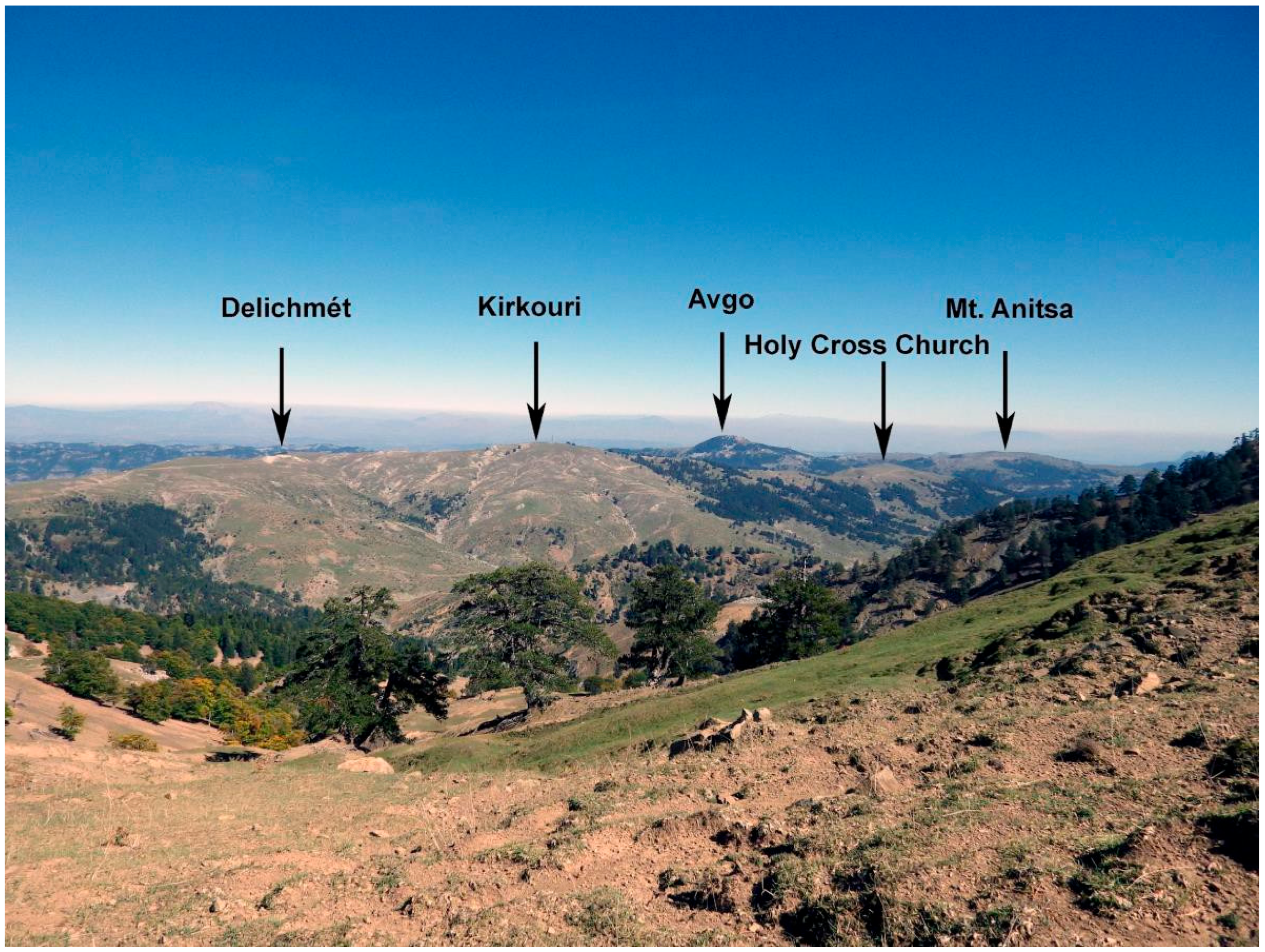
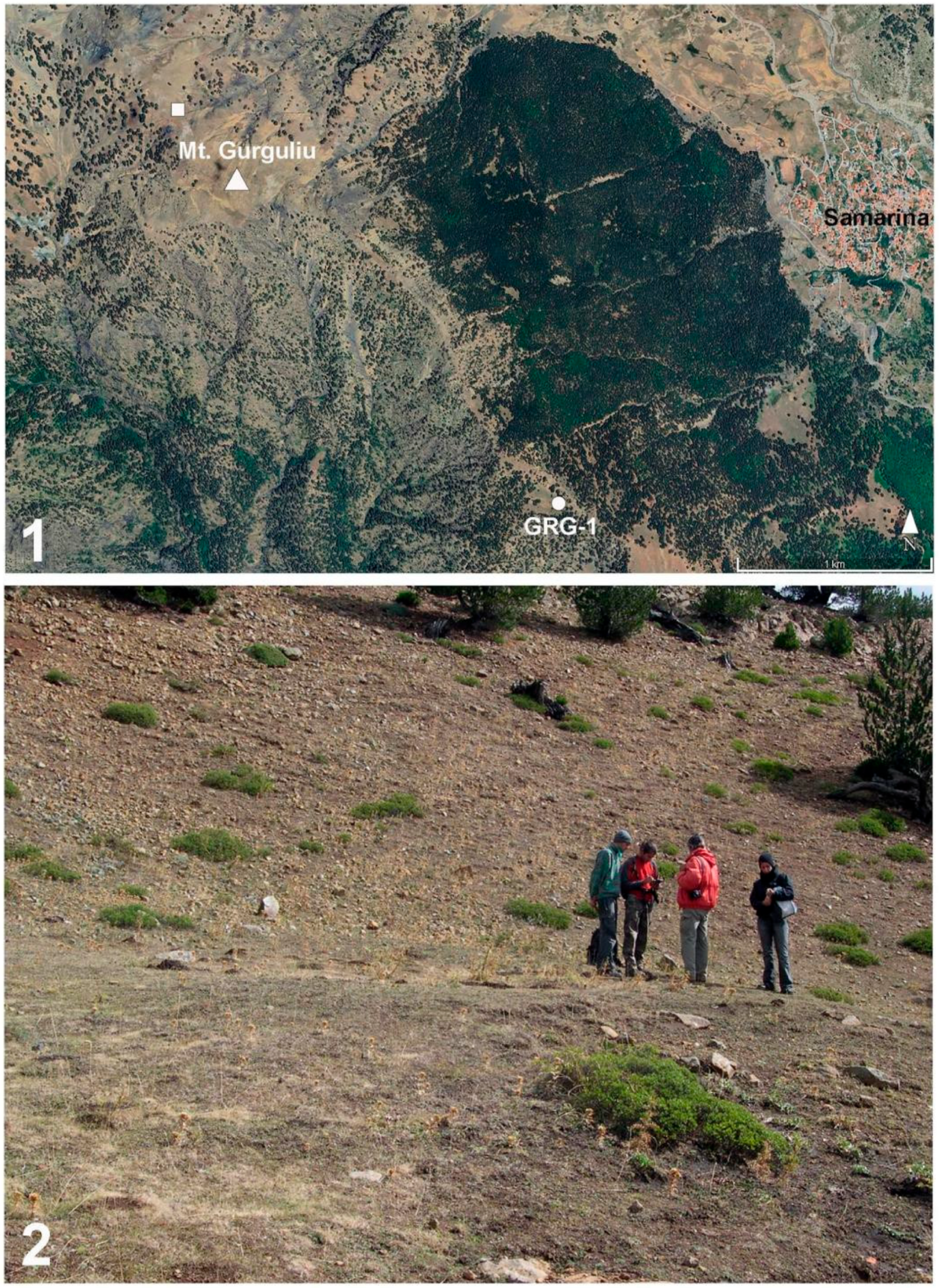
Following these premises, potsherds were collected on the surface in the highlands that surround Samarina during surveys conducted within a territory that spans approximately 80 square kilometers. The surveyed landscape is delimited, in the north, by La Greklu Saddle (1742 m a.s.l.), which separates Western Macedonia from Epirus ([14], p. 204); the Mirminda Pass in the south (1566 m a.s.l.); the Vasilitsa Pass (1774 m a.s.l.), Mt. Bogdhani (2238 m a.s.l.), and Gurguliu (2253 m a.s.l.) watershed in the west; and the ridge that extends from La Greklu across Delichmét (1776 m a.s.l.) and Mt. Kirkouri (1850 m a.s.l.) to Mt. Anitsa in the southeast (1706 m a.s.l.) (Figure 1). Each survey season lasted between 2 and 4 weeks. The fieldwork was conducted on foot by 3 to 5 persons between the end of August and the beginning of October each year. Soviet Military Maps (sheet K-34-139-3 and K-34-138-4) were used in the fieldwork to define the original names of the different localities reported in this paper. The coordinates and altitudes of all the archeological finds were recorded using a Garmin GPS device.
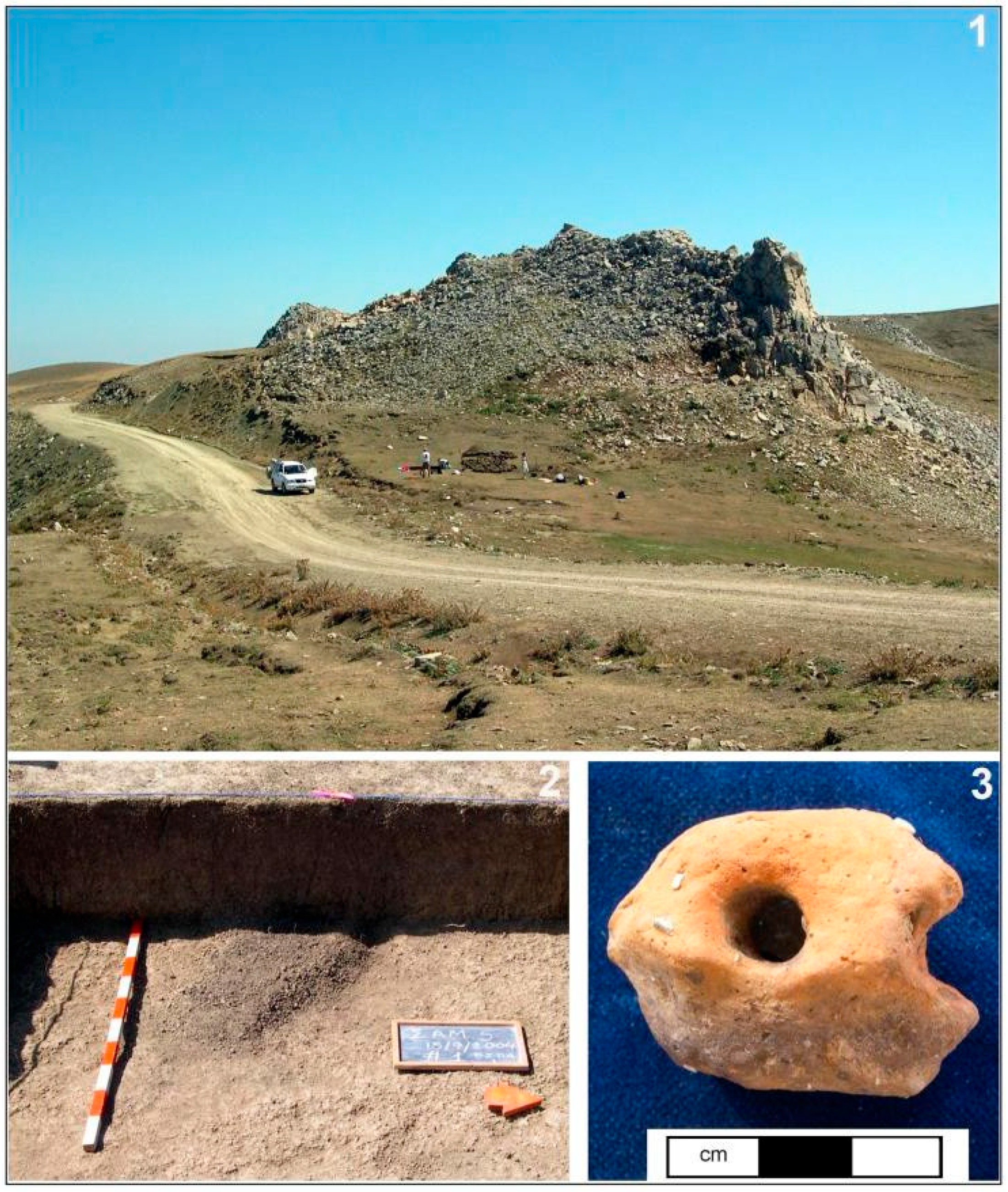
Small trial trenches were opened in some well-defined areas, including Delichmét (Sam-5) and the Historical Camp (HC), located northwest of Samarina. These two sites are discussed in this paper because they yielded ceramic potsherds and archeological radiocarbon-dated features attributed to the Byzantine and later historical periods. Sam-5 is located at Delichmét, just west of the earthen road that moves along the ridge. A trial trench was opened in September 2004 in a sheltered zone east of the limestone outcrop that characterizes the area (40°06′41.9′′ N–21°00′31.3′′ E: 1778 m a.s.l.). A small, oval hearth was uncovered in the northern part of the trench ca 50 cm below the surface. Two unidentified charcoal samples were AMS radiocarbon dated to 1127 ± 25 BP (DEM-1918/OxA-16623) and 1129 ± 26 BP (DEM-1917/OxA-16222), which attribute the structure to the Early Byzantine period (8th–9th centuries AD) [36]. Close to the hearth, the fragment of a weathered two-holed ceramic lug was recovered (Figure 2).
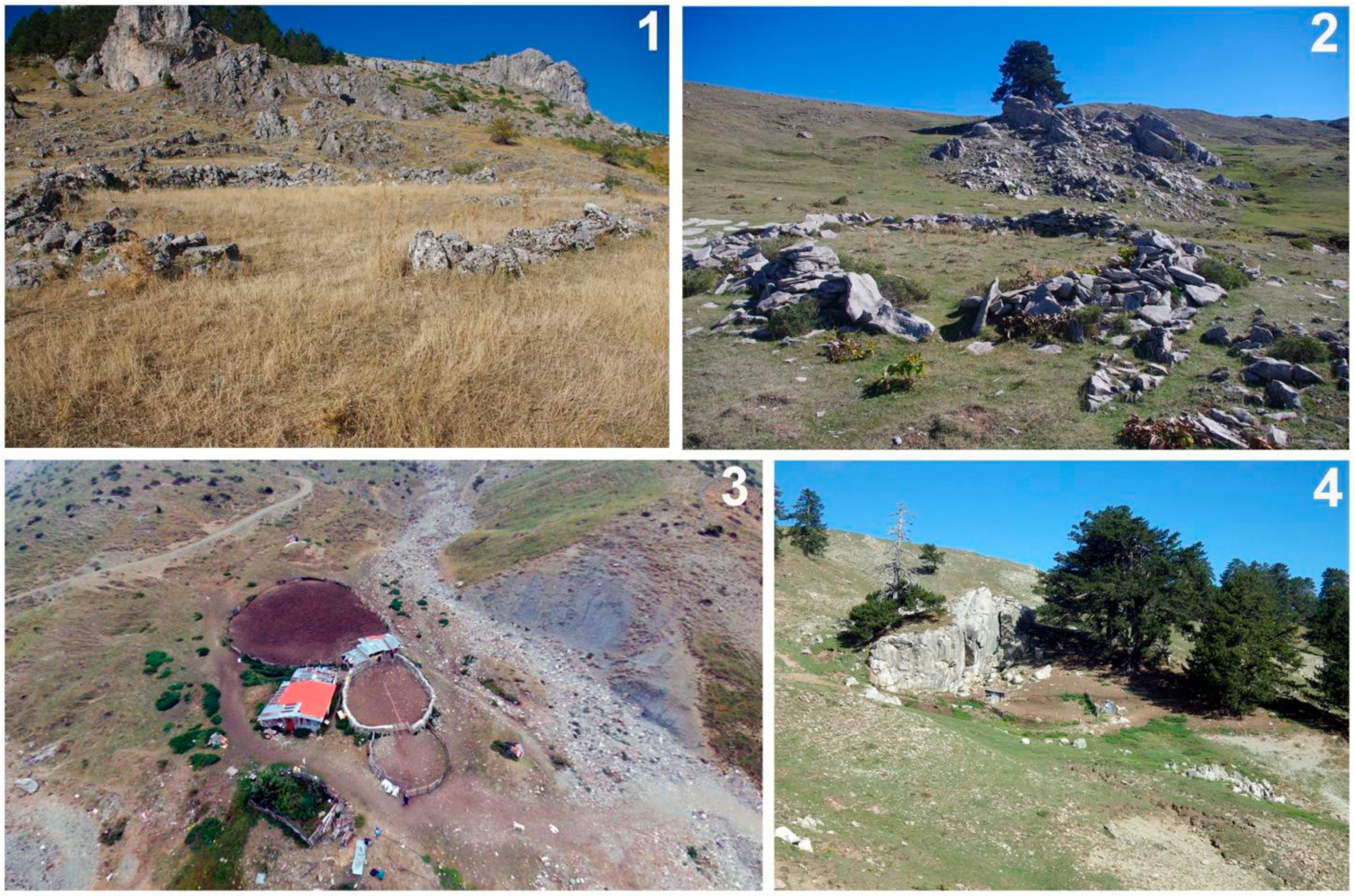
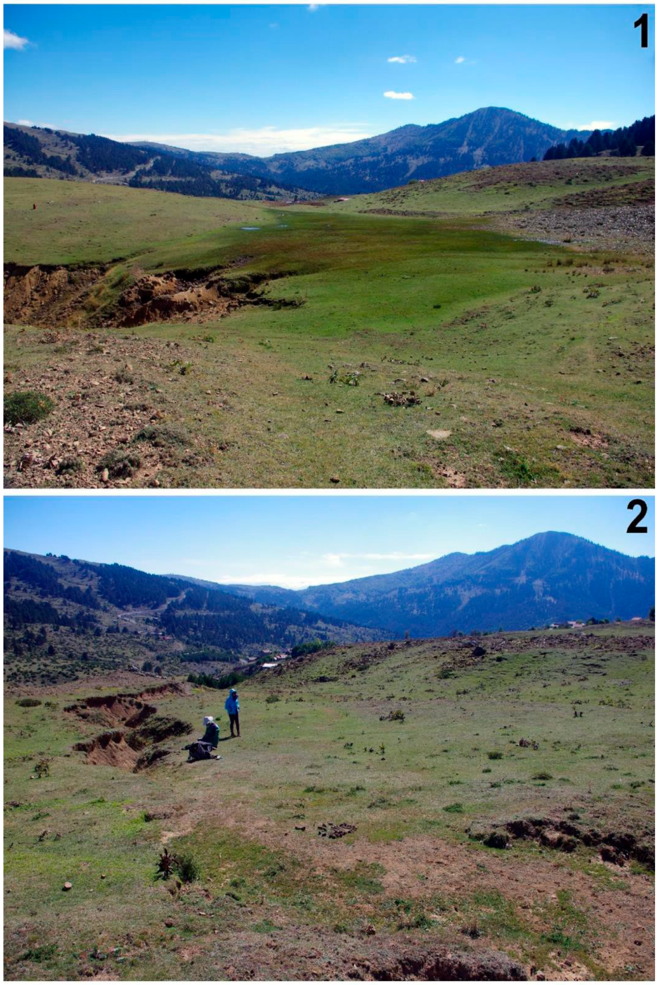
The Historical Camp (HC) is located immediately northwest of Samarina, along the lowermost eastern slopes of Mt. Gurguliu. The area consists of a vast, morainic, deforested region between approximately 1500 and 1570 m a.s.l., marked by several small ponds and incised by numerous seasonal streams. HC is a grazing area with a few recent (wooden) and old (stone-walled) corrals (stâni), some of which have been restored and are still in use (Figure 3).
Describing the northern outskirts of Samarina, Wace and Thompson remarked “were there no woods above the village to protect it from the torrents formed by snow and rain” ([14], p. 39), and the hillside of the town is not on firm ground. This was due to intensive deforestation, the traces of which have been recorded in archeological research [13]. The area was called Historical Camp (HC) following the discoveries made in 2006. One 2 × 3 m trench was opened at 40°06′41.3′′ N–21°00′33.9′′ E (1567 m a.s.l.) close to a deep gully with evidence of a thick charcoal deposit. The excavation did not yield material culture remains (Figure 4).
However, important archeological features, among which are postholes, shallow pits filled with charred juniper twigs, and a surface reddened by heat, were uncovered during excavation, suggesting the presence of a hut or a tent (?). A juniper charcoal sample collected from one of the burning pits yielded a date of 1414 ± 18 BP (DEM-2586). The date shows that the area was settled in the Early Byzantine 7th century AD. Radiocarbon dates obtained from 8 of the many tree-pits mapped in the area ([13], Figure 25 [37]) suggest that the upland was systematically and repeatedly deforested, most probably to open pastures for grazing sheep and goats throughout a long period between the Roman Empire and the 15th–16th centuries AD ([13], Table 1). A few ceramic potsherds have been collected from the surface of this important archeological area (see below).
Figure 4. Historical Camp (HC). The northernmost part (1) and the gully where excavations were carried out in 2006 (2). Mt. Vasilitsa is visible in the background (photographs by P. Biagi, 2018).
Heritage 08 00500 g004
Potsherds have been collected from the surface of Mt. Kirkouri (KRK), the Holy Cross Church (SMC), Mt. Anitsa (Anitsa), Avgo (VGO), the Mirminda Pass (VLC), Mt. Vasilitsa (VLS), and the saddle that separates Mt. Bogdhani from Mt. Gurguliu. Mt. Kirkouri is located along the watershed that extends from the La Greklu Pass in the north as far as Mt. Anitsa (Delichmét Watershed) in the south. Most potsherds were collected along the southern slope of Mt. Kirkouri near the earthen road that leads to the Holy Cross Church. A few more potsherds were collected from the surface of the hillock on the top of which the small church was built. Mt. Anitsa is significant due to its strategic location. The surrounding territory can be easily controlled from the top of the mountain. The strategic importance of Mt. Anitsa is confirmed by its role during the Italian invasion of Greece in 1940–1941 and the Battle of Pindos [38] (Figure 5).
The top of Mt. Anitsa was settled during the Middle Bronze Age. Excavations carried out at Sam-23 yielded potsherds typical of this period. A juniper charcoal sample collected during excavation was radiocarbon dated to 4005 ± 35 BP (GrA-59661) ([13], Table 1). Moreover, a bronze coin was found near a spring that Vlach shepherds still utilize to water their flocks along the northwestern upper slope of the mountain at 1664 m a.s.l. (40°05′44.66′′ N–21°04′53.08′′ E).
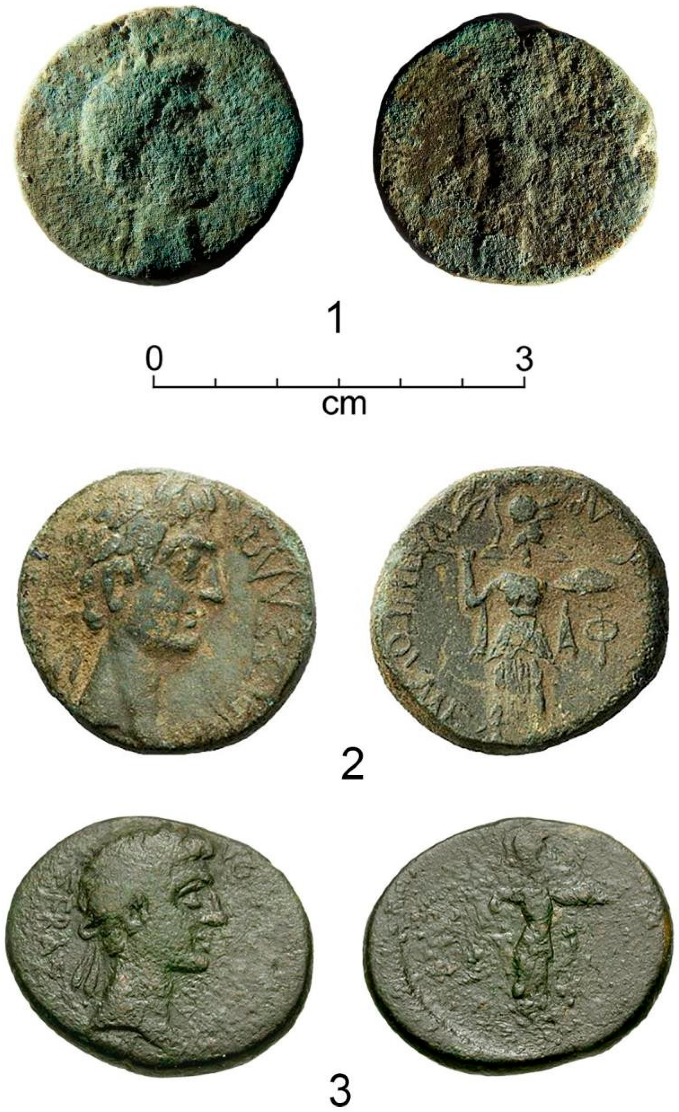
The coin is not in very good condition. However, it is possible to identify it with a diassarion, issued by the Thessalian League during the period of the Emperor Augustus (27 BC-AD 14, RPC I, 1428). The mint is that of Larissa. The presence of this coin in the mountains around Samarina suggests that the practice of pastoral transhumance from the Thessalian Plain to the mountain pastures of the Pindus Range likely dates back to the Roman Imperial era (Figure 6).
Description of the identified coin
Augustus (27 BC-AD 14). Koinon of Thessaly
Emperors’ issuers: Augustus and Tiberius
Date: 27 BC–AD 14
Obverse legend and description: ΣΕΒAΣΤHΩΝ ΘΕΣΣAΛΩΝ, laureate head of Augustus right
Reverse legend and description: ΣTPATHΓOΥ MEΓAΛOΚΛΕOYΣ API, Athena Itonia standing right, brandishing spear and shield with ΦY to right
Diameter: 23 mm
Thickness: 3 mm
Weight: 9.54 g
Axis: 6 h
Mint: Larissa
Metal: Bronze
Denomination: diassarion
Struck/Cast: struck
References: RPC I 1428 [39], Burrer 98 [40], Rogers 66-7 [41], McClean 4993 [42]
Avgo is an impressive, almost circular rock outcrop (1574 m a.s.l.) located ca 2 km northeast of Mt. Anitsa. Along its southern slope, a still well-preserved stone-walled stâni ([43], Figure 2, n. 2) was built. A few historical potsherds have been found in this area.
Of unique importance is the Mirminda (Morminda) Pass (VLC: 1554 m a.s.l.), which separates the Samariniotikos Valley in the north from the slopes that gently move towards the Grevena lowlands in the south. Here are located the springs that flow down into the Morminda stream, an affluent of the Samariniotikos, a perennial watercourse, which south of Samarina takes the name of Greko and then turns to the west to enter a steep, narrow valley where its name changes to Vijosë, as it is often reported by classical authors ([19], p. 265).
The Mirminda Pass is a crucial geopolitical point that divides two main river networks: those that flow into the Ionian and those that flow into the Aegean. Consequently, the Mirminda Pass is a significant point crossed by people moving from different regions, which can help interpret the origins of prehistoric and historical communities.
Some 10 km east of it, the strategic Hellenistic city of Kastrì is located on the top of a hillock at 1033 m a.s.l. along the course of the Smixiotikos [44]. Here, the river crosses a narrow gorge before entering the Venetikos/Aliakmon fluvial network, which flows into the Aegean (Figure 7).
The ridge that leads from the Mirminda Pass to Mt. Anitsa yielded a great variety of archeological finds of different ages, among which are historical potsherds. Additional ceramic fragments were collected from a locality near to the Vasilitsa Pass, which separates Western Macedonia from Epirus.
The distribution of the potsherds reported above extends mainly along the watershed that runs from La Greklu, in the north, to Mt. Anitsa and the Mirminda Pass, in the south. This ridge, locally called Delichmét Watershed (see above), is still nowadays exploited by Vlach shepherds to feed their flocks during the good season, roughly from June to mid-October [14]. The watershed is deforested and easy to walk through. It is punctuated by several springs and small ponds where sheep and goats water, old and recent corrals (stânis), and small churches, a few of which have collapsed in the recent times, most likely during the Civil War, such as the Mt. Kirkouri one. The presence of archeological finds of differing ages, among which are those reported in this paper, is not surprising. Together with the Historical Camp, this is one of the most important grazing areas exploited by the Samarina shepherds.
Figure 7. (1) The fortified Hellenistic city of Kastrì, near Polyneri (black arrow); (2) the Smixiotikos River which flows below the city and the open valley west of it (photographs by P. Biagi, 2014 and 2015).
Heritage 08 00500 g007
The situation is very different along the steep ridge that extends from the Vasilitsa Pass, in the south, to La Greklu, in the north, crossing the mountains of Bogdhani (2253 m a.s.l.) and Gurguliu (2238 m a.s.l.). Apart from the Vasilitsa finds reported above, two “Slavic Ware” potsherds chronologically attributed to the 9th century AD were collected on the surface of the saddle that separates the two mountain peaks. Following a footpath, the saddle extends to Mt. Mosia and then Mt. Smolikas (2647 m a.s.l.) and across them down to the steep valleys of Epirus. We know little about human activities in the region during the recent past. A small ore smelting area was discovered in 2008 at an elevation of 1939 m a.s.l. along the upper western slope of Mt. Bogdhani (GRG-1: 40°05′33.4′′ N–20°59′55.1′′ E). The site was AMS-radiocarbon dated to 1755 ± 30 BP (GrA-59658), corresponding to the 3rd–4th centuries AD, during the Roman conquest ([13], Table 1) (Figure 8). These data confirm that different communities moved across this ridge and temporarily settled to carry out some kind of activity in this difficult challenging mountain zone at least in two distinct historical periods.
Along the upper slopes of Valia Kalda, south of Mt. Smolikas, Wace and Thompson [14] and also Hammond [19] reported stone-walled structures, traces of ancient mining, and an area covered with slags near Perivoli and Avdela, where the presence of native copper was first reported in 1954. Unfortunately, all these sites are undated. We do not know when and why they were abandoned, which may have occurred for various reasons ([45] p. 192). These data document the complexity of human activities that took place in the area during some specific periods of the 1st millennium AD.

2.2. The Pottery Assemblages

The pottery assemblage analyzed in this study comprises 150 potsherds, 27 of which were considered diagnostic (Table 1).
Table 1. Summary of the principal characteristics of the ceramic assemblage collected at the different sites.
SiteSample NameTot. n. of PotsherdsDiagnostic SherdsRepresented GroupsChronology
Historical CampHC659C2, G4, G5, G66th c. AD?
KirkouriKRK393A2, G3, G4, G54th–7th c. AD
Mts. Gurguliu/Bogdhani-22“Slavic Ware”9th c. AD
Mt. AnitsaNTS62F1, G3Undefined
Holy Cross ChurchSMC93G2, G4Undefined
AvgoVGO83A3, A4, G2, G3Undefined
Aspra PetraSPR11A1Undefined
Mt. VasilitsaVSL193G16th–12th c. AD
Mirminda PassVLC11G3Undefined
TOTAL 15027
The remaining 123 are body sherds or small fragments of various fabric types attributable to different functional categories. All the available data, including provenance, GPS coordinates, and altitude of the findings are reported in the database (see Supplementary Table S1). Whenever possible, the suggested chronological attribution or the radiocarbon date of the site have been reported.

Methodology

The ceramics were classified according to distinctive parameters such as type, body, firing, shape, and decoration, which are considered indicators for chronological attribution and production identification. A distinction was made between coarse pottery, which features clearly visible mineral inclusions and is unglazed, and fine pottery (with refined bodies), classified based on the porosity of the body (porous or compact) and the presence of glaze [46,47].
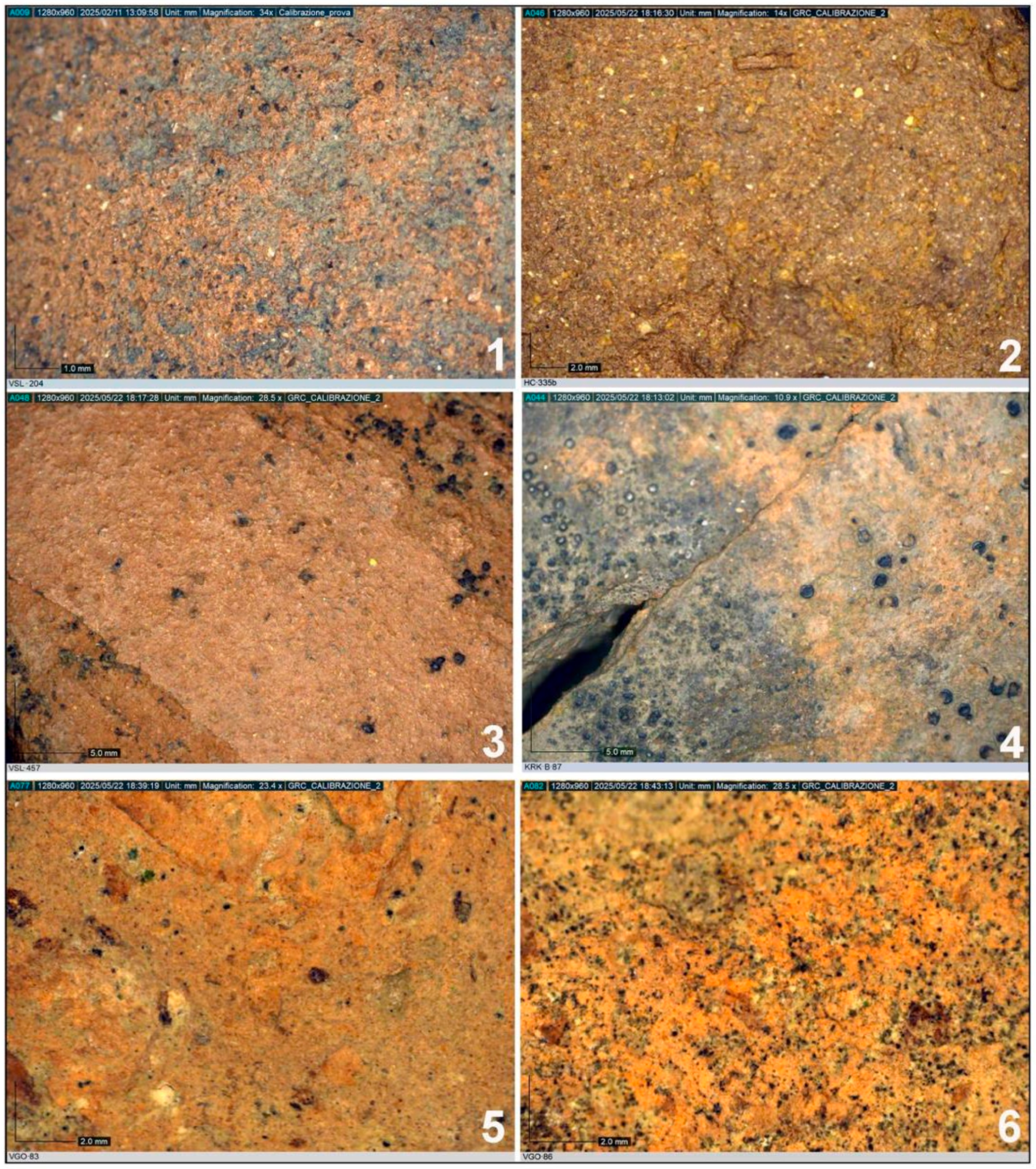
A detailed description of the ceramic fragments includes the macroscopic characteristics of both fabrics and surfaces and their color assessed using a Munsell Soil Color Chart, 2009. Inclusions were reported mainly through direct observation, in some cases with the help of a 20× hand lens. The fabrics were examined with a Dino-Lite digital microscope, which allows for accuracy in identifying inclusions and surface treatment marks on the vessels’ surfaces [48]. The samples were classified according to the characteristics of the fabrics (hardness, porosity, inclusion quantity and distribution, grain size) following the parameters suggested by N. Cuomo di Caprio [48], and were subdivided into different categories according to vessel shape.

3. Results

3.1. Typology

The nomenclature used to describe each potsherd and the parameters employed for classifying their characteristics are those proposed in the Handbook for Archeological Ceramics written by N. Cuomo di Caprio [48]. Morphological and typological comparisons were made through bibliographic references, which helped to interpret the vessels’ function and use.
Although small, this database is the first pottery corpus ever published from the Pindos Region of Western Macedonia.
The ceramics were typologically described as classes (see the following paragraphs), and within them, the fabric groups identified with the aid of a Dino-Lite microscope were observed and described. The ceramic class was identified based on the production technique, function, typology, or, when possible, dating. The production technique is primarily defined by the shaping technique, surface finishing (smoothing, engobe, glaze, etc.), and firing. Functional criteria fundamentally distinguish ceramics for the consumption, preparation, firing, storage, and transportation of food, as well as all terracotta items for non-food purposes. Typology is understood in the sense that a ceramic class may include one or more typologies. The fabric groups refer to the clay raw materials and inclusions, since fabric type depends on the desired final product and its properties, such as strength and porosity.

3.1.1. Coarse Ware

Cooking Pots
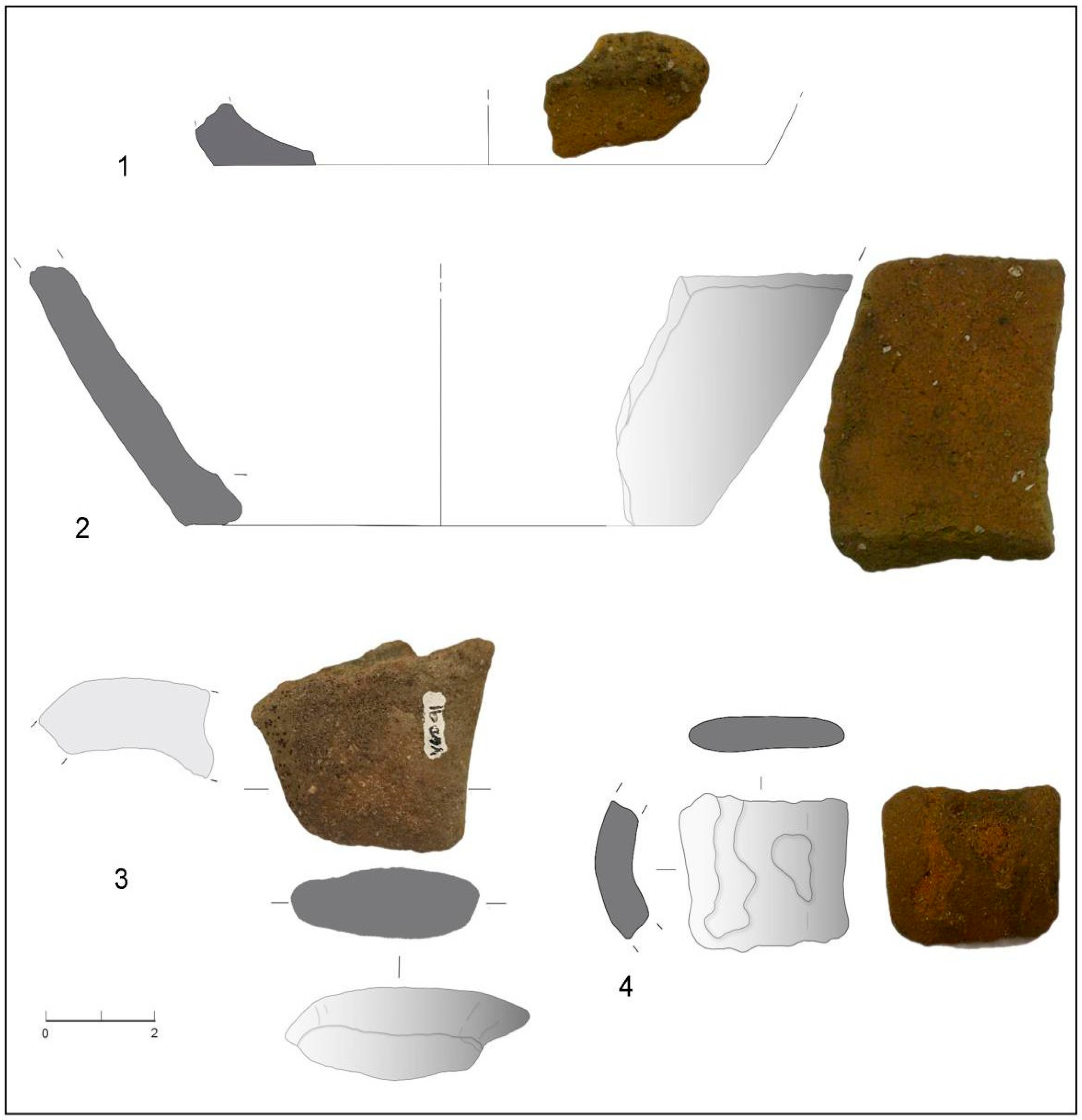
HC-271 (Figure 9, n. 1)
Provenance: Historical Camp
Suggested chronology: 6th century AD?
Ceramic Group: G4
Description: Rim fragment with a triangular cross-section set on the neck.
Semi-hard, compact, slightly porous fabric of 7.5YR 5/4 light brown color. The inner and outer surfaces are rough and dusty from 5/4 yellowish red to 7.5YR 6/6 reddish brown. Visible inclusions are white, grey (quartz), and red (chamotte), abundant in distribution and medium in grain size (visible to the naked eye).
White and black post-depositional traces are present on the surface.
Rim ⌀ ca 21.0 cm
Remaining height: 1.4 cm
KRK-B-75 (Figure 9, nn. 2 and 3)
Provenance: Kirkouri
Suggested chronology: 4th–7th centuries AD
Ceramic Group: G4
Description: Rim fragment with a triangular cross-section, flattened at the top with a double groove on the outer wall just below the lip and flat base.
Semi-hard, compact, and slightly porous fabric of color 7.5YR 5/4 light brown. The inner and outer surfaces are rough and dusty, with a 5YR 5/6 reddish yellow hue. Visible inclusions are white, grey (quartz), and red (chamotte), abundant in distribution and medium in grain size. Wheel-throwing marks and surface blackening from use are present.
Rim ⌀ ca 6.0 cm
Base ⌀ ca 13.4 cm
Rim remaining height: 2.1 cm
Base remaining height: 1.9 cm
Saddle between Mts. Gurguliu and Bogdhani-a (Figure 9, n. 4)
Provenance: Mts. Gurguliu/Bogdhani
Suggested chronology: 9th century AD
Production: “Slavic Ware”
Description: Rim fragment with rounded, everted lip.
Fabric and surface are 10YR 5/4 yellowish-brown color. White inclusions, moderately distributed and medium in grain size, are visible. Traces of smoothing tool marks on the surface.
Remaining height: ca 6.0 cm
Wall thickness: 0.7 cm
HC-272 (Figure 9, n. 5)
Provenance: Historical Camp
Suggested chronology: Undefined
Ceramic Group: G4
Description: Flat base fragment.
Semi-hard, compact, slightly porous fabric of 7.5YR 5/4 light brown color. The inner and outer surfaces are rough, ranging from 5/4 yellowish red to 7.5YR 6/6 reddish brown. Inclusions are white, grey (quartz), and red (chamotte), with a medium distribution and grain size. White and black post-depositional traces are present.
⌀ ca 6.0 cm
Remaining height: 1.6 cm
Wall thickness: 0.2 cm
HC-254 (Figure 9, nn. 6 and 7)
Provenance: Historical Camp
Suggested chronology: Undefined
Ceramic Group: G4
Description: Two flat base fragments of a cooking pot.
Semi-hard, compact, slightly porous fabric of 7.5YR 5/4 light brown color. The surface is rough and dusty, internal color is 5YR 5/4 yellowish red, external is 5YR 6/4 light reddish brown. One fragment shows a possible trace of a vitreous coating inside. Inclusions are white, grey (quartz), and red (chamotte), abundant and large-grained.
⌀ 9.8 cm and 11.4 cm
Remaining height: 2.5 cm and 1.2 cm
Anitsa-218 (Figure 10, n. 1)
Provenance: Mt. Anitsa
Suggested chronology: Undefined
Ceramic Group: G3
Description: Flat base fragment of a cooking pot.
Semi-hard, porous fabric of 5YR 6/6 reddish yellow color. Surface is rough and dusty; internal color is 5YR 5/6 yellowish red, external is 10YR 4/2 dark greyish brown. Inclusions: white, grey (quartz), red (chamotte), black, and micaceous, abundant and coarse-grained. Wheel-throwing marks are visible on the internal wall; external blackening is likely due to fire exposure.
⌀ 9.6 cm
Remaining height: 1.0 cm
SMC-366 (Figure 10, n. 2)
Provenance: Holy Cross Church
Suggested chronology: Undefined
Ceramic Group: G2
Description: Flat base fragment.
Semi-hard, porous, slightly lamellar fabric of 10YR 6/3 pale brown color. The surface is rough, the internal color is 10YR 6/3 pale brown, and the external color is 2.5YR 4/6 red. Inclusions: white, grey (quartz), red (chamotte), and black, abundant and medium-grained. Wheel-throwing marks and slight external blackening are visible.
⌀ ca 9.2 cm
Remaining height: 4.2 cm
VGO-91 (Figure 10, n. 3)
Provenance: Avgo, north of Anitsa
Suggested chronology: Undefined
Ceramic Group: G2
Description: Handle fragment.
Hard, compact, slightly porous sandwich fabric, with color ranging from 2.5YR 5/8 red to 7.5YR 5/1 grey. The surface is rough, dark grey (10YR 4/1). Inclusions: white, grey (quartz), red (chamotte), and black, abundant with fine to medium grain size. Wheel throwing marks inside; slight blackening outside.
Remaining height: 1.5 cm
HC-447 (Figure 10, n. 4)
Provenance: Historical Camp
Suggested chronology: Undefined
Ceramic Group: G4
Description: Handle fragment.
Semi-hard, compact, slightly porous fabric of 5YR 5/6 red color. Rough surface; internal color is 2.5YR 5/6 red, external is 7.5YR 4/3 brown. Inclusions are white, grey (quartz), and red (chamotte), abundant and medium-grained. Slight blackening on the outer surface.
Remaining height: 2.7 cm
Cooking Pots with Decoration
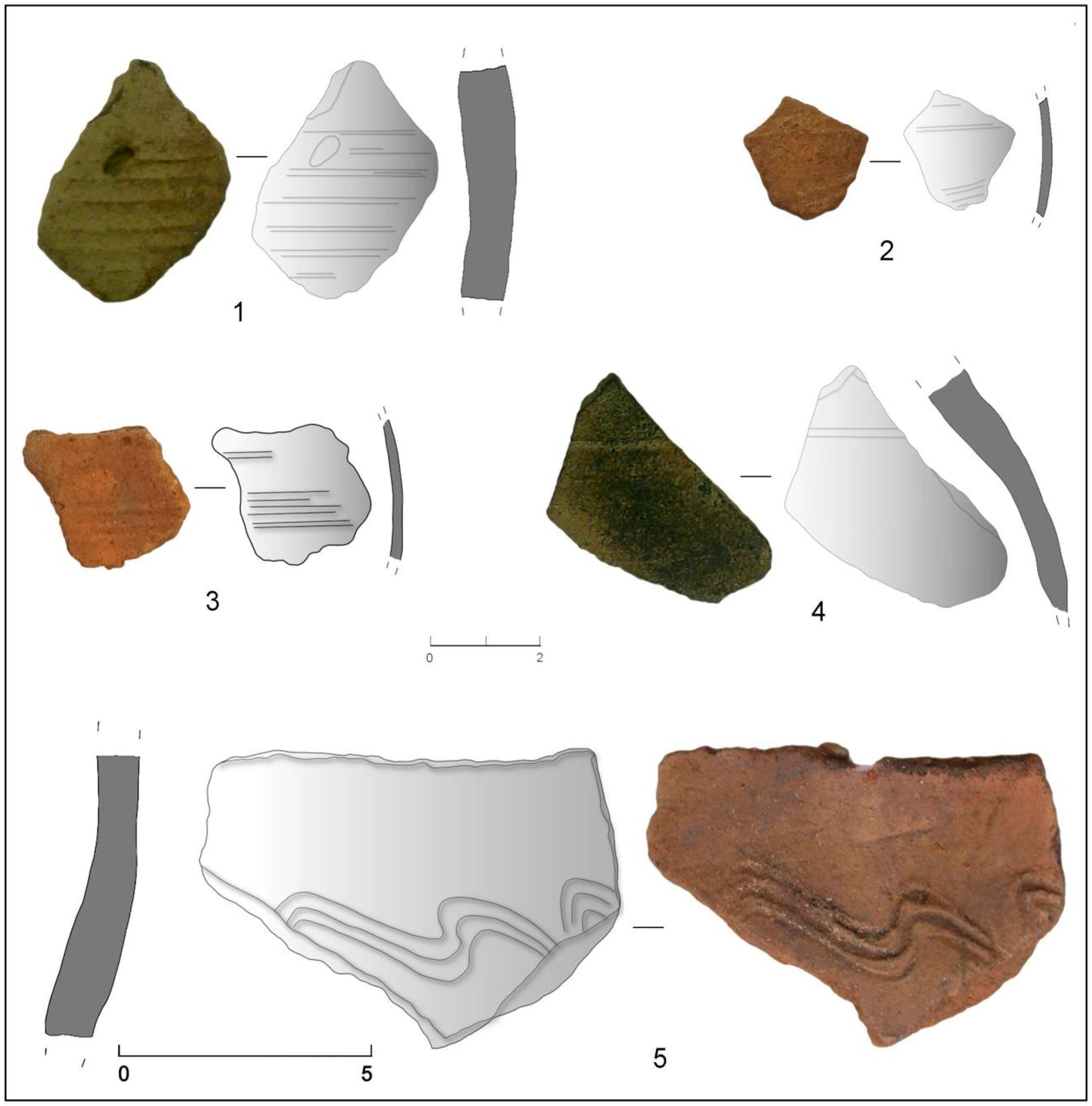
SMC-379 (Figure 11, n. 1)
Provenance: Holy Cross Church
Suggested chronology: Undefined
Ceramic Group: G2
Description: Wall sherd decorated with spatula incised bands.
The fabric is soft, with a 2.5YR 5/8 red hue. Both internal and external surfaces are smooth and powdery with a uniform 7.5YR 5/3 brown color. The visible inclusions are white, grey (quartz), red (chamotte), and black, with abundant distribution and medium grain size. A large void (ca 6 mm long) is visible on the external surface.
Preserved height: 3.9 cm
Wall thickness: 1.1 cm
HC-272 (Figure 11, n. 2)
Provenance: Historical Camp
Suggested chronology: Undefined
Ceramic Group: G4
Description: Wall sherd decorated with comb-incised bands.
The fabric is semi-hard, compact, and slightly porous, with a 7.5YR 5/4 light brown color. The internal and external surfaces are rough, with a color range from 7.5YR 5/4 yellowish red to 7.5YR 6/6 reddish brown. Visible inclusions include white, grey (quartz), and red (chamotte), with medium distribution and grain size (visible to the naked eye). White and black diagenetic deposits are present on the surface.
Estimated diameter: ca 6.0 cm
Preserved height: 1.6 cm
Wall thickness: 0.2 cm
Figure 9. Coarse ware fragments of cooking pots. Historical Camp: rim fragment with triangular cross-section set on the neck (HC-271, (1)); flat base of a jar (HC-272, (5)); two flat base fragments of a cooking pot (HC-254, (6,7)). Kirkouri: rim fragment with triangular cross-section, flattened at the top with a double groove on the outer wall just below the lip (KRK-B-75, (2)); flat base fragment of a cooking pot (KRK-B-75, (3)). Mts. Gurguliu/Bogdhani: rim fragment with rounded, everted lip recognizable as “Slavic Ware” (Saddle between Mts. Gurguliu and Bogdhani-b, (4)) (drawings and photographs by V. Merlini).
Heritage 08 00500 g009
Figure 10. Coarse ware fragments of cooking pots. Mt. Anitsa: flat base fragment of a cooking pot (Anitsa-218, (1)). Holy Cross Church: flat base fragment of a cooking pot (SMC-366, (2)). Avgo: handle fragment (VGO-91, (3)). Historical Camp: flat handle fragment (HC-447, (4)) (drawings and photographs by V. Merlini).
Heritage 08 00500 g010
SMC-416 (Figure 11 n. 3)
Provenance: Holy Cross Church
Suggested chronology: Undefined
Ceramic Group: G2
Description: Wall sherd decorated with spatula incised bands.
The fabric is semi-hard, compact, and slightly porous with 7.5YR 5/6 yellowish red color. The internal and external surfaces are slightly rough and powdery with variable colors (5YR 4/3 reddish brown, internal, and 2.5YR 5/6 red, external). Inclusions are white, grey (quartz), red (chamotte), and black, with abundant distribution and coarse grain size. Post-depositional concretions are visible on the internal surface, extending into the break.
Preserved height: 2.4 cm
Wall thickness: 0.7 cm
VLC-61 (Figure 11, n. 4)
Provenance: Mirminda Pass
Suggested chronology: Undefined
Ceramic Group: G3
Description: Wall sherd decorated with a single spatula incised band.
The fabric is semi-hard and porous with a 2.5Y 4/1 dark greyish-brown color. The internal and external surfaces are rough and differ in color: 7.5YR 5/4 brown (internal) and 7.5YR 3/1 very dark grey (external). Visible inclusions include white, grey (quartz), red (chamotte), black, and mica, with abundant distribution and medium grain size. Traces of fast-wheel turning are evident on the internal surface. A blackening on the internal wall may indicate use near a heat source.
Preserved height: 4.1 cm
Wall thickness: 0.5 cm
Saddle between Mts. Gurguliu and Bogdhani-a (Figure 11, n. 5)
Provenance: Mts. Gurguliu/Bogdhani saddle
Suggested chronology: 9th century AD
Production: “Slavic Ware”
Description: Wall fragment bearing a wavy incised decoration on the external surface. The fabric color is 7.5YR 5/6 strong brown. Visible inclusions include white, grey, and red particles, with a medium distribution and medium grain size, except for a few large grey fragments visible in fracture. The outer surface exhibits areas of blackening, possibly resulting from proximity to a heat source.
Wall thickness: 0.4 cm
Preserved height: ca. 5.0 cm

3.1.2. Fine Common Ware: Ollae

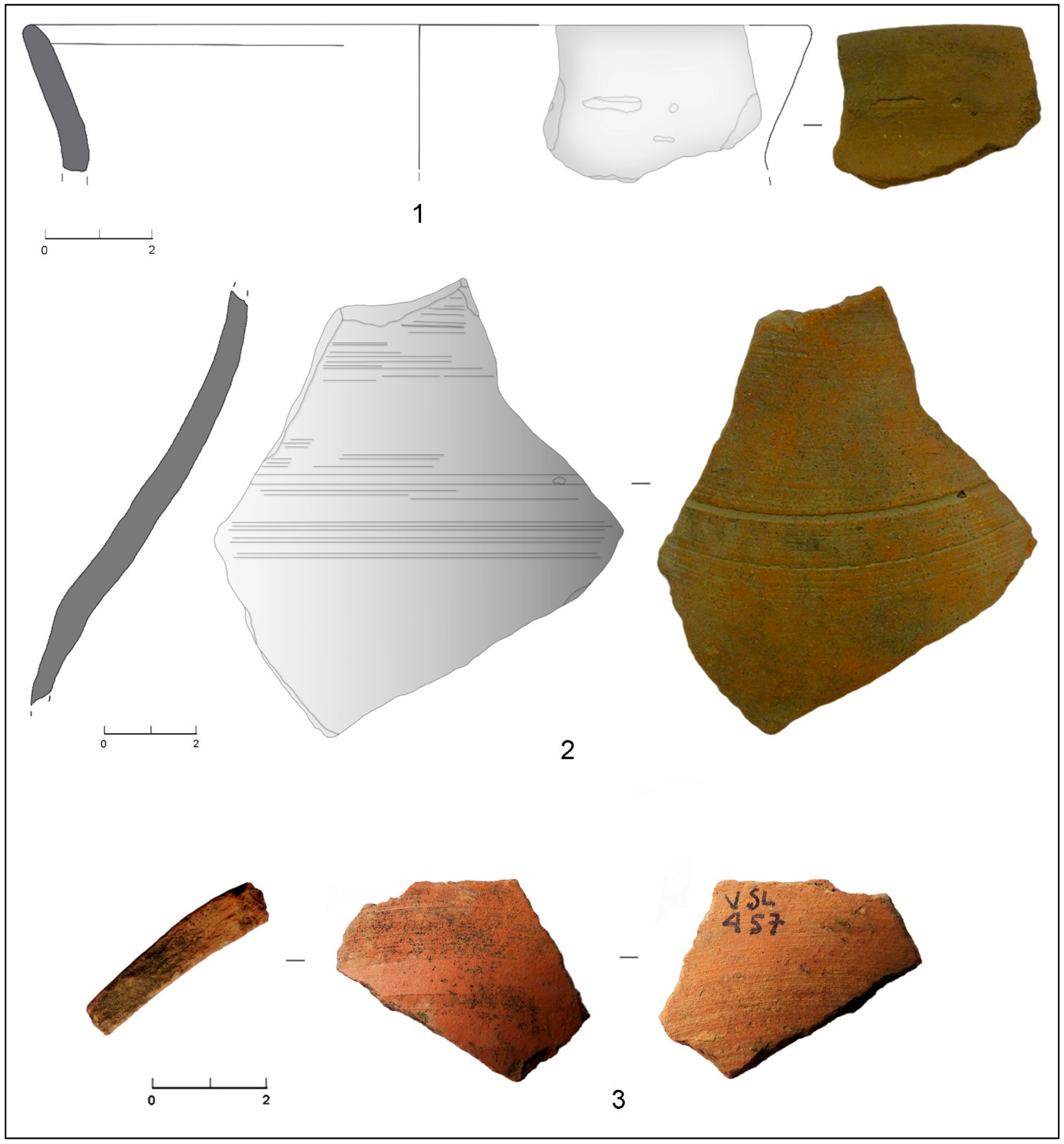
HC-335a (Figure 12, n. 1)
Provenance: Historical Camp
Suggested chronology: Undefined
Ceramic Group: C3
Description: Rim fragment with slightly everted and rounded upper edge; two incised decorations are present on the wall: a horizontal notch and a circular impression. The fabric is semi-hard and compact, with a color of 5YR 5/6 yellowish red. The surface is smooth, with variable colors transitioning between the interior (5YR 5/6 yellowish red) and the exterior (7.5YR 5/3 brown). Inclusions are white, grey, and micaceous, with rare distribution and fine grain size. Traces of fast wheel throwing are visible on the interior surface.
⌀ ca 14.4 cm
Preserved height: 2.2 cm
Figure 11. Coarse ware fragments of cooking pots. Holy Cross Church: wall sherd decorated with spatula incised bands (SMC-379, (1)); wall sherd decorated with spatula incised bands (SMC-416, (3)). Historical Camp: wall sherd decorated with comb-incised bands (HC-272, (2)). Mirminda Pass: wall sherd decorated with one single spatula incised band (VLC-61, (4)). Mts. Gurguliu/Bogdhani saddle: wall fragment with wavy incised decoration on the external surface interpreted as “Slavic Ware” (saddle between Mts. Gurguliu and Bogdhani-a, (5)) (drawings and photographs by V. Merlini).
Heritage 08 00500 g011
Figure 12. Fine common ware fragments: Olla from the Historical Camp: rim fragment with a slightly everted and rounded upper edge and two incised decorations on the wall (HC-335a, (1)). Globular vessel from Mt. Vasilitsa: neck sherds from a jug with incised decoration (VSL-204, (2); wall sherd with banded slip VSL-457, (3)) (drawings and photographs by V. Merlini and E. Starnini).
Heritage 08 00500 g012

3.1.3. Globular Vessel

VSL-204 (Figure 12, n. 2)
Provenance: Mt. Vasilitsa
Suggested chronology: Undefined
Ceramic Group: C1
Description: Neck sherds from a jug with applied spatula incised decoration.
The fabric is semi-hard, vacuolated with 10YR 7/3 very pale brown color. The surface is rough and powdery with 5YR 6/6 yellowish-red color. Visible inclusions include white, grey, red (chamotte), and micaceous particles, with abundant distribution and medium grain size. Traces of fast wheel throwing are visible on the surface.
Wall thickness: 0.5–0.7 cm
Preserved height: 9.9 cm
VSL-457 (Figure 12, n. 3)
Provenance: Mt. Vasilitsa
Suggested chronology: 6th–12th c. AD
Ceramic Group: V1
Description: Wall sherd belonging to a globular vessel with a smooth surface, with a color matching 2.5YR 5/8 red. The exterior is coated with a glossy, banded slip and varnish in the color 2.5YR 5/6 red. Semi-hard and compact fabric; matrix color is 2.5YR 5/6 red; dominant inclusions (20× hand lens observation) in white, black, and mica; sparse distribution; fine grain size.
Preserved height: 3.3 cm
Wall thickness: Average 7 mm.
Production indicators: presence of fast wheel throwing marks and surface scraping traces.

3.1.4. Transport Containers: Amphorae

SPR-7 (Figure 13, n. 1)
Provenance: Stâni Aspra Petra, Historical Camp
Suggested chronology: Subrecent?
Ceramic Group: A1
Description: Wall sherd from a transport container.
The fabric is hard, compact, and lamellar with a 2.5YR 5/4 reddish-brown color. The surface is smooth and shows chromatic distinctions between the internal, 7.5YR 5/4 brown, and the external, 5YR 5/4 reddish brown. White and black rare inclusions with a fine grain size are visible.
Wall thickness: ca 1.0 cm
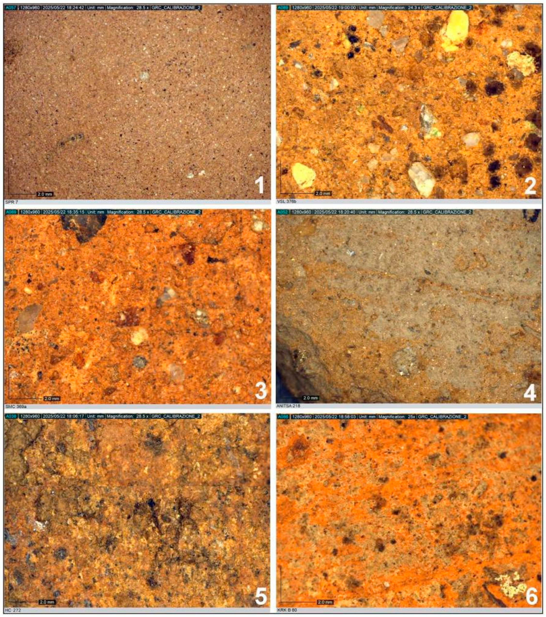
Figure 13. Specimens of ceramic fabric using Dino-Lite microscope: Amphorae: Group A1 (SPR-7, (1); magnification 28.5×). Coarse ware: Group G1 (VSL-376b, (2): magnification 24.3×); Group G2 (SMC-369a, (3): magnification 28.5×); Group G3 (Anitsa-218, (4): magnification 28.5×); Group G4 (HC-272, (5); magnification 28.5×); Group G5 (KRK-B-80, (6): magnification 25×) (photographs by V. Merlini).
Heritage 08 00500 g013

3.2. Ceramic Fabric Groups

3.2.1. Coarse Ware

Group 1 (G1)
Sample: VSL-376b (Figure 13, n. 2)
Macroscopic description: Hard, compact, and vacuolar fabric; matrix color is 7.5YR 4/4 brown. Rough surface of 7.5YR 5/6 strong brown color. No slip or glaze observed.
Inclusions: Dominant inclusions (macroscopic observation, 20x) in white, grey, red (chamotte), and mica; abundant, coarse grain size.
Fracture: Regular.
Wall thickness: Average 7 mm.
Group 2 (G2)
Sample: SMC-369a (Figure 13, n. 3)
Macroscopic description: The fabric is semi-hard, vacuolar, and slightly laminated; the matrix color is 10YR 5/3 brown. Surface is smooth and soapy to the touch; internal surface color is 10YR 6/3 pale brown, external surface is 2.5YR 5/6 red. No slip or glaze observed.
Inclusions: Dominant inclusions (macroscopic observation, 20×) in white, grey, red (chamotte), and black; abundant distribution with coarse grain size.
Fracture: Regular.
Wall thickness: Average 6 mm.
Group 3 (G3)
Sample: Anitsa-218 (Figure 13, n. 4)
Macroscopic description: The fabric is semi-hard and vacuolar; the matrix color is 5YR 6/6 reddish yellow. Rough surfaces with an internal color of 5YR 5/6 yellowish red, external surface color of 10YR 4/2 dark greyish brown. No slip or glaze observed.
Inclusions: Dominant inclusions (macroscopic observation, 20×) in grey, white, black, red (chamotte), and mica; abundant distribution with coarse grain size.
Fracture: Regular.
Wall thickness: Average 5 mm.
Production indicators: Fast wheel throwing marks on the internal surface of the wall; blackening visible on the external surface.
Group 4 (G4)
Sample: HC-272 (Figure 13, n. 5)
Macroscopic description: The fabric is semi-hard, compact, and slightly vacuolar; the matrix color is 7.5YR 5/4 brown. Rough surface color from 5YR 5/4 yellowish red to 7.5YR 6/6 reddish yellow. No slip or glaze observed.
Inclusions: Dominant inclusions (macroscopic observation, 20×) in white, grey, and red (chamotte); medium distribution with medium grain size.
Fracture: Regular.
Wall thickness: Average 5 mm.
Group 5 (G5)
Sample: KRK-B-80 (Figure 13, n. 6)
Macroscopic description: Hard, compact, slightly vacuolar fabric; matrix color is 2.5YR 6/6 light red. Slightly rough surface of 2.5YR 5/6 red color. No slip or glaze observed.
Inclusions: Dominant inclusions (macroscopic observation, 20×) in white, grey, and mica; medium distribution with fine grain size.
Fracture: Regular.
Wall thickness: Average 5 mm.
Production indicators: Traces of fast wheel throwing.

3.2.2. Fine Common Ware Fabrics

Group 1 (C1)
Sample: VSL-204 (Figure 14, n. 1)
Macroscopic description: Hard and vacuolar fabric; matrix color is 10YR 7/3 very pale brown; rough and powdery surface; surface color is 5YR 6/6 yellowish red. No slip or glaze observed.
Inclusions: Dominant inclusions (20× hand lens observation) in white, grey, red, and mica; medium distribution and medium grain size.
Fracture: Regular.
Wall thickness: Average 6 mm.
Production indicators: Fast wheel throwing marks on the interior surface.
Group 2 (C2)
Sample: HC-335b (Figure 14, n. 2)
Macroscopic description: Semi-hard and compact fabric; matrix color is 5YR 5/6 yellowish red; smooth surface; internal surface color is 5YR 5/6 yellowish red; external surface color is 7.5YR 5/3 brown. No slip or glaze observed.
Inclusions: Dominant inclusions (20× hand lens observation) in grey, white, and mica; sparse distribution; fine grain size.
Fracture: Regular.
Wall thickness: Average 5 mm.
Production indicators: Fast wheel throwing marks.
Figure 14. Specimens of ceramic fabric using Dino-Lite microscope: Refined common ware: Group C1 (VSL- 204, (1); magnification 34×); Group C2 (HC-335b, (2): magnification 14×). Fine tableware: Group V1 (VSL-457, (3): magnification 28.5×). Amphorae: Group A2 (KRK-B-87, (4): magnification 10.9×); Group A3 (VGO-83, (5): magnification 23.4×); Group A4 (VGO-86, (6): magnification 28.5×) (photographs by V. Merlini).
Heritage 08 00500 g014

3.2.3. Fine Tableware Fabrics

Group 1 (V1)
Sample: VSL-457 (Figure 14, n. 3)
Macroscopic description: Semi-hard and compact fabric; matrix color is 2.5YR 5/6 red. The surface is smooth, with a color matching 2.5YR 5/8 red.
Inclusions: Dominant inclusions (20× hand lens observation) in white, black, and mica; sparse distribution; fine grain size.
Fracture: Regular.
Wall thickness: Average 7 mm.
Production indicators: Presence of fast wheel throwing marks and surface-scraping traces.

3.2.4. Amphorae Fabrics

Group 1 (A1)
Sample: SPR-7 (Figure 13, n. 1)
Macroscopic description: Hard, compact, and laminated fabric; matrix color is 2.5YR 5/4 reddish brown. Surface is smooth; internal surface color is 7.5YR 5/4 brown, external surface is 5YR 5/4 reddish brown. No slip or glaze observed.
Inclusions: Dominant inclusions (20× hand lens observation) in white and black; sparse distribution; fine grain size.
Fracture: Regular.
Wall thickness: Average 10 mm.
Group 2 (A2)
Sample: KRK-B-87 (Figure 14, n. 4)
Macroscopic description: Hard and compact fabric; matrix color is 2.5YR 6/6 light red. Surface slightly rough; surface color is 2.5YR 5/6 red. No slip or glaze observed.
Inclusions: Dominant inclusions (20× hand lens observation) in grey and mica; medium distribution; medium grain size.
Fracture: Regular.
Wall thickness: Average 7 mm.
Production indicators: Fast wheel throwing marks observed.
Group 3 (A3)
Sample: VGO-83 (Figure 14, n. 5)
Macroscopic description: Hard, compact, and laminated fabric; matrix color is 2.5Y 6/1 grey. The surface is smooth and powdery; the surface color is 5YR 7/8 reddish yellow. No slip or glaze observed.
Inclusions: Dominant inclusions (20× hand lens observation) in white and red (chamotte); sparse distribution; fine grain size.
Fracture: Regular.
Wall thickness: Average 11 mm.
Production indicators: Possible overfiring (stracotto).
Group 4 (A4)
Sample: VGO-86 (Figure 14, n. 6)
Macroscopic description: Hard, compact, and laminated fabric; matrix color is 10YR 6/2 light brownish grey. Surface slightly smooth and powdery; surface color varies between 10YR 6/3 pale brown (internal) and 2.5YR 7/8 light red (external). No slip or glaze observed. Inclusions: Dominant inclusions (20× hand lens observation) in white and red (chamotte); sparse distribution; fine grain size.
Fracture: Irregular.
Wall thickness: Average 10 mm.
Production indicators: Possible overfiring (stracotto). Black post-depositional concretions are present on the outer surface and fracture.

4. Discussion

Regarding the pottery in this study, the fabric composition and vessel shapes of the analyzed assemblage varied. The scarcity of diagnostic features and comparative data from the study region made the chronological attribution and the identification of the workshop provenance of many fragments problematic, which is not surprising given the mountain location of the study region [4]. However, the available data show that the ridges and passes surrounding Samarina were frequented during various historical periods, which is confirmed by a substantial number of radiocarbon dates [13]. Previous archeological, ethnographic, and topographic research has highlighted the presence of various communities settling in this Pindos highland zone [49,50]. The transhumant nature of these groups, particularly the Vlachs, is confirmed mainly by the presence of typical stone-walled pastoral structures or corrals (stâni). The well-established presence of Vlach shepherds raises some issues regarding the chronology of their arrival in Samarina, which is generally placed sometimes before the Late Byzantine 14th century AD. However, this topic is still intensely debated due to the scarcity of reliable data. During the centuries that followed, and especially during the Ottoman Empire, the territory was intensively exploited, giving way to a significant process of deforestation to open new pastures [14,19,28,37].
The case of the Slavic groups is different. The circumstances of their arrival are better understood following migration waves that took place since the late 6th century AD ([51], pp. 108–126) marking their first movements south of the Danube into the Balkan Peninsula ([52], p. 283, [53,54]). However, some aspects of their settlements and material culture remain ambiguous, and the identification of their presence needs to be correlated with toponymic studies [24]. In this respect, the discovery of two characteristic potsherds on the surface of the saddle located at 2141 m a.s.l. between Mt. Gurguliu and Mt. Bogdhani is noteworthy.
They consist of one rounded, outflaring rim jar (Figure 9, n. 4) and one wall sherd decorated with parallel, incised wavy lines (Figure 11, n. 5). The latter, in particular, finds comparisons in the so-called “Slavic Ware”, which is characterized by waving incised line patterns on the vessel shoulder. These ceramics were first identified in three different settlements of this period located around Grevena, where they were most probably produced [24]. These are the best examples currently available from the territory near Samarina as well as from other sites across Greece, including Olympia and Argos [55,56]. The two potsherds are the first ever recovered from the Pindos Mountains. In this territory, the Slavs have always been suggested to have never practiced high-altitude and long-distance pastoralism ([24], p. 285). Moreover, we cannot necessarily assume that they were brought up there by Slav herders, a topic that is still a matter of debate [54]. In contrast, we know that Slav communities settled in significant numbers in the Grevena lowlands, where “Slavic Ware” vessels have always been recorded within a 3 km radius of the many villages where Slavs settled ([24], pp. 283–284) and are suggested to have been produced locally ([24], p. 282). The two typical coarse potsherds reported above belong to jars featuring an internal glaze, typically in olive green or brown hues. Although in limited quantities, a similar glaze is also found on the internal surfaces of other fragments in the examined group, especially HC-254 (Figure 9, nn. 6 and 7) and HC-431.
Another small rim fragment (HC-271: Figure 9, n. 1) has been included in this group. It shows morphological characteristics comparable to those of cooking vessels attributed to the Slavic occupation from various Balkan and Greek sites [49,55,56]. The rounded and slightly everted rim profile is typical of early medieval functional types associated with rural settlement sites [57,58]. These containers are chronologically attributed to the 9th century AD and are generally interpreted as local products used for agricultural storage, often associated with semi-permanent settlements [24,59]. Their presence in high-altitude passes or highland zones fits into the suggested distribution of the “Slavic Wares”, corresponding to the agricultural and pastoral lifestyle of the Slavic communities. Thus, these fragments relate to the new wave of Slavic occupation that characterized the region in the medieval period. The remaining coarse ware potsherds provide less chronological information. However, they inform us about the types of ceramic vessels utilized by local communities, most likely the Vlachs, even though, as already pointed out, transhumant communities very rarely manufacture ceramic vessels for their everyday needs, including milking and making dairy products [1,3,4].
Other pieces show features related to their function, such as the flat bases of cooking pots or ollae, e.g., SMC-366 (Figure 10, n. 2) and Anitsa-218 (Figure 10, n. 1). The blackening observed on their outer surface may indicate proximity to a hearth and suggests they were used for cooking. Direct exposure to fire could have caused the body to crack, which explains the widespread preference in antiquity and the medieval period for dishes that were cooked for a long time. In contrast, three flat bases (two fragments HC-254: Figure 9, nn. 6 and 7; HC-272: b Figure 9, n. 5) do not show such traces, suggesting they may have been used as pantry containers or belonged to part of the vessel that was not in contact with fire.
Two small handle fragments (VGO-91: Figure 10, n. 3 and HC-447: Figure 10, n. 4) exhibit a surface treatment that parallels that of the mid-13th century AD cooking vessels [60].
Traces of use or manufacturing marks can be observed on some wall sherds. These fragments vary not only in fabric but also in decoration. They often consist of parallel or single bands spaced at regular intervals, suggesting the use of a comb-like tool during fast wheel throwing to achieve an orderly effect. Fragment SMC-379 (Figure 11, n. 1) is the only one with wide grooves, likely made with a rib tool, on the entire outer surface. It also features a depression 0.6 cm wide, possibly an air bubble or void that formed during firing, perhaps due to excess water in the fabric or burning off of organic material.
Fragment VLC-61 (Figure 11, n. 4) has one single incised band made with a rib tool and external blackening; some areas also show additional decoration. It may have functioned as a cooking vessel, similar to SMC-366 and Anitsa-218. Conversely, the decorated wall fragments HC-272 (Figure 11, n. 2) and SMC-416 (Figure 11, n. 3) may have been employed as storage vessels. The blackening on HC-272 may be due to the production or firing process rather than fire use. SMC-416 does not show such marks. Another noteworthy coarse ware rim fragment features a triangular section with a flattened upper surface and a double decorative groove below the lip. In some Italian contexts, this shape is attributed to a period after the 4th century AD ([61], p. 181). The absence of use-wear supports a tableware or storage function.
The fine, depurated common ware consists of 23 potsherds. This class is characterized by a more refined production technique, both in fabric preparation and ceramic body, and is associated with storage or table use rather than cooking.
The rim fragment HC-335a (Figure 12, n. 1) shows high-quality craftsmanship. The outer wall bears two distinct incised decorations: a horizontal notch (1.0 cm long) and a small circular mark. Smoothing marks made with a rib tool are also visible, contributing to the wall’s uniform thickness. A group of 17 fragments from Mt. Vasilitsa belongs to the same ceramic group (C1), characterized by a bright orange, highly friable fabric. Nine are small undiagnostic sherds, while eight consist of decorated wall fragments or sherds with fine fast wheel turning marks which may belong to the same vessel or a single production unit. However, the initial preparation of the clay matrix looks less refined given the presence of many voids. The wall fragment VSL-204 (Figure 12, n. 2) is the best-preserved specimen. It features two grooves, one thicker than the other, alongside thin parallel incisions across the surface, likely created by a comb tool. Similar to SMC-379 (Figure 11, n. 1), it exhibits a visible void (~0.2 cm) on the outer surface. This may be the neck of a jug or, more likely, a globular serving vessel.
One fragment has been attributed to the category of fine ceramic tableware. The first (VSL-457: Figure 14, n. 3) is a body sherd with traces of light red painted stripes on the external surface, attributable to an early medieval, red-striped ware production. The high-quality manufacture and technical expertise suggest either an early medieval or an Imperial Roman production.
According to their macroscopic characteristics and wall thickness, three body sherds have been classified as transport or storage vessels. VGO-83 (Figure 14, n. 5) and VGO-86 (Figure 14, n. 6) show a dense, grey hard fabric perhaps due to overfiring during the manufacturing process. The similarity of their physical characteristics suggests a common, though as yet unidentified, provenance.
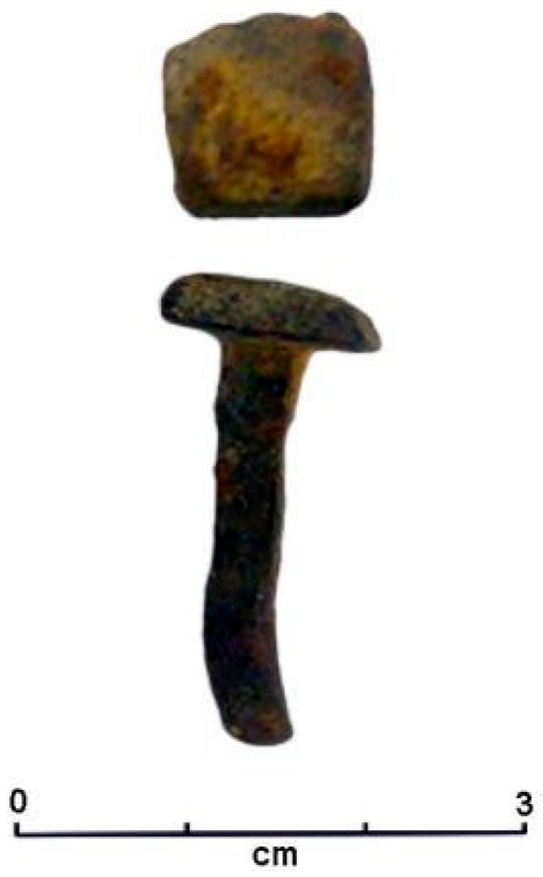
Among the other finds, an iron nail from the Vasilitsa Pass can be attributed to a contemporary context. It shows the continuity of frequentation of these highland zones up to the present (Figure 15).

5. Conclusions

The different potsherds from various historical periods recovered during the surveys carried out in the Samarina highlands exhibit a variety of fabrics and techno-typological characteristics that may contribute to the reconstruction of the lifestyle of communities that seasonally settled in the highlands of this region.
The analysis of the pottery assemblage from the Samarina region reveals a significant diversity in fabric composition and vessel shapes, which reflect the complex history of settlement in the area. While the lack of diagnostic features and comparative data presents challenges in establishing precise chronologies and workshop origins for many of the fragments, the available evidence nonetheless offers valuable insights into the region’s historical development.
Attributing the assemblage with precision, typologically and chronologically, is challenging, as most of the sherds are too small and lack diagnostic features. Moreover, they have been collected during surface surveys and lack stratigraphic data except for the case of site Sam-5. We must consider that the transhumant pastoralist mountain lifestyle relies on the seasonal exploitation of natural resources, including wood, flint chert, minerals, and plants, leaving behind few archeological traces ([62], p. 100, [63]). A comprehensive understanding requires the integration of historical, ethnographic, and archeobotanical data as well as radiocarbon dating. However, combining the results of the present study with other data obtained from previous research, we can infer human presence in these mountains with oscillating population density, from prehistory to the present [64], though for different purposes.
The few diagnostic vessel fragments fit into the characteristics of the typical highland zone economy based on pastoral activities. They were designed for long-term, multipurpose use, particularly for storing and consumption of regional goods in sturdy, non-perishable containers [53,60,61]. Moreover, the predominance of cooking vessels is consistent with the limited need of fine ware vessels among the Vlachs, particularly during the period preceding their more permanent settlement ([25], pp. 266–267). Until a few decades ago, the Vlachs were primarily engaged in managing sheep and goat flocks, from which they obtained milk, cheese, and wool for textile products ([14], pp. 164–165).
Archeobotanical research conducted in the area, combined with radiocarbon dating, has favored the identification of prolonged phases of pastoral land use. In particular, during the Late Roman and Early Byzantine periods, in the 3rd, 5th, and 7th centuries AD, deforestation was carried out in some areas, reshaping the landscape and making open spaces suitable for grazing ([43], p. 585). The Vlachs practiced and still practice spring and autumn transhumance, moving from the northern Pindos Mountains around Samarina to the Thessalian Plain and vice-versa, bringing their flocks and consuming the products that they had stored during the summer months [14,32,49].
Our chronological frame is based on a good series of radiocarbon dates obtained from many tree-ring features uncovered in the Historical Camp [13], the Early Byzantine hearth excavated at Sam-5 and its related potsherd (Figure 2), and the recovery of “Slavic Ware” fragments in the highland zone of Mt. Gurguliu (Figure 9, n. 4). Regarding the Roman period, the presence of a Larissa diassarion is a very robust proxy not only from a chronological but also from a provenance point of view (Figure 6). It was found near a spring on Mt. Anitsa which Vlach shepherds currently use to water their flocks. It can be considered a proxy for the exploitation of these pastures by shepherds as early as the Roman Imperial age.
These data and the material culture assemblages recovered from the Samarina historical sites confirm the presence of humans in the region during well-defined periods, contributing to the interpretation of the chronology of the Vlach settlement in the area. Despite the fragmentary state of the pottery, some potsherds derive from typical vessel forms, while others are typologically diagnostic of specific vessel forms. Their presence reinforces the existence of contacts with the neighboring Grevena lowlands.
However, we have to point out that the data collected from the Grevena lowlands and the Samarina highlands reveal a contrasting pattern. This is due to the low presence of prehistoric sites in the lowlands and the systematically increasing number of historical sites discovered in the Grevena region [9]. This pattern contrasts with that available from Samarina, where the number of prehistoric, mainly Pleistocene, findspots and concentrations of knapped stone artefacts are overwhelming in comparison to sites of later periods.
These data are fascinating and should also be considered from an altitudinal perspective to combine the information between the two aforementioned adjacent zones and interpret how people moved from one region to another, why, and when. The results obtained from the study of historical ceramic fragments and the radiocarbon results obtained so far from the Samarina highland sites are significant, as they come from an unknown region of the mountains of northwestern Greece and can be considered innovative.
Data available from the Grevena lowlands [26,65] suggest that “Slavic Ware” pottery manufacture likely began with the arrival of new peoples.
In conclusion, the Samarina highlands have yielded important archeological finds which inform us of the area’s frequentation since the Middle Paleolithic [10,12,13]. The historical artifacts consist of potsherds, structural remains, and traces of tree-pit deforestation features which have been AMS radiocarbon dated to provide a robust picture of the activities conducted in the area and the reason for these activities. As expected, the ceramic finds are relatively few, considering that they were collected over the course of 15 years of archeological surveys. However, their limited number is realistic. This is due to the scarcity of ceramic containers used by transhumant communities in general and the absence of pottery workshops in the area, which is attributable to Vlach groups. The Samarina highlands began to be frequented during the time of Emperor Augustus some 2000 years ago. How sporadically or more systematically they continued to be exploited, we do not know yet. We know that ores were discovered and exploited in the area a few centuries later, during the Roman conquest ([19] p. 265). It is not known with certainty when the Vlach shepherds started to live in the area. Sites radiocarbon dated to the Byzantine period, along with the presence of typical “Slavic Ware” potsherds attributed to the 9th century AD, are very helpful in this respect. They not only testify to the presence of shepherds in the area and the importance of pastoralism [66] but also inform us of their relationships with communities that settled in the neighboring Grevena lowlands. Finally, fine ceramics, which include a few finely crafted tableware and storage vessels, suggest a level of technological refinement and social complexity, likely tied to elite or specialized use. The variations in fabric quality and decoration reflect different production techniques, possibly linked to other workshops or communities whose sources are most likely to be found in the Grevena lowlands as already suggested. This diversity in ceramic forms, combined with the evidence of changing land-use patterns and settlement structures, highlights the multifaceted nature of the Samarina region’s historical and cultural development over the centuries.

Supplementary Materials

The following supporting information can be downloaded at: https://www.mdpi.com/article/10.3390/heritage8120500/s1, Table S1. Discovery location and most important characteristics of the ceramic potsherds discussed in this paper.

Author Contributions

Conceptualization, P.d.V.; methodology, P.d.V. and V.M.; software, P.d.V. and V.M.; writing, original draft preparation, P.d.V., V.M., and P.B.; writing, review, and editing, P.d.V., V.M., P.B., E.S., and N.E.; funding acquisition, N.E., P.B., and E.S. All authors have read and agreed to the published version of the manuscript.

Funding

This research was jointly supported by funds from the Aristotle University, Thessaloniki (Greece), Ca’ Foscari University of Venice (Italy), the University of Pisa (Italy — PRA 2022-17, Pratiche artigiane tra Mediterraneo ed Oriente. Studi interdisciplinari dalla Preistoria al Medioevo, P.I.: S. Menchelli), the Prefecture of Western Macedonia (Greece), and the Institute for Aegean Prehistory (INSTAP).

Data Availability Statement

All data used in this study are presented in the article.

Acknowledgments

The authors are very grateful to T.M. Lucchelli of Ca’ Foscari University of Venice for the identification of the coin and the revision of its description and to all the participants in the surveys and excavations conducted during many years of fieldwork in the Samarina highland zone. The authors are grateful to the three reviewers who contributed significantly to improving the quality of the paper. Special thanks are due to C. Bonsall of Edinburgh University (UK) for the revision of the English text and to F. Curta (Florida University, USA) for bibliographic advice and the useful discussions.

Conflicts of Interest

The authors declare no conflicts of interest.

References

  1. Chang, C. Pastoral Transhumance in the Southern Balkans as a Social Ideology: Ethnoarcheological Research in Northern Greece. Am. Anthropol. 1993, 95, 687–703. [Google Scholar] [CrossRef]
  2. Nandris, J.G. The Stina and the Katun: Foundations of a Research Design in European Highland Zone Ethnoarchaeology. World Archaeol. 1985, 17, 256–268. [Google Scholar] [CrossRef]
  3. Cribb, R. Nomads in Archaeology; Cambridge University Press: Cambridge, UK, 1991. [Google Scholar]
  4. Fragnoli, P. Pottery production in pastoral communities: Archaeometric analysis on the LC3-EBA1 Handmade Burnished. Ware from Arslantepe (in the Anatolian Upper Euphrates). J. Archaeol. Sci. Rep. 2018, 18, 318–332. [Google Scholar] [CrossRef]
  5. Biagi, P.; Nandris, J. (Eds.) Highland Zone Exploitation in Southern Europe; Monografie di Natura Bresciana; Museo Civico di Scienze Naturali di Brescia: Brescia, Italy, 1994; Volume 20, pp. 7–338. [Google Scholar]
  6. Ammerman, A.J.; Efstratiou, N.; Adam, E. First evidence for the Palaeolithic in Aegean Thrace. In The Palaeolithic Archaeology of Greece and Adjacent Areas. Proceedings of the ICOPAG Conference, Ioannina; Bailey, G.N., Adam, E., Panagopoulou, E., Perlès, C., Zachos, K., Eds.; British School at Athens Studies 3: London, UK, 1999; pp. 211–214. [Google Scholar]
  7. Wilkie, N.C.; Savina, M.E. The Earliest Farmers in Macedonia. Antiquity 1997, 71, 201–207. [Google Scholar] [CrossRef]
  8. Wilkie, N.C. Some Aspects of the Prehistoric Occupation of Grevena. In Ancient Macedonia VI. Papers Read at the Sixth International Symposium Held in Thessaloniki, October 15–19, 1996; Institute of Balkan Studies: Thessaloniki, Greece, 1999; Volume 2, pp. 1345–1357. [Google Scholar]
  9. Apostolou, G.; Venieri, K.; Mayoral, A.; Dimaki, S.; Garcia-Molsosa, A.; Georgiadis, M.; Orengo, H.A. Integrating Legacy Survey Data into GIS-Based Analysis: The Rediscovery of the Archaeological Landscapes in Grevena (Western Macedonia, Greece). Archaeol. Prospect. 2024, 31, 37–52. [Google Scholar] [CrossRef]
  10. Efstratiou, N.; Biagi, P.; Elefanti, P.; Karkanas, P.; Ntinou, M. Prehistoric exploitation in Grevena highland zones: Hunter andherders along the Pindus chain of Western Macedonia (Greece). Word Archaeol. 2006, 38, 415–453. [Google Scholar] [CrossRef]
  11. Biagi, P.; Efstratiou, N.; Starnini, E.; Nisbet, R. Traces of Mesolithic occupation in the Pindos Mountains of western Macedonia (Greece). Mesolith. Misc. 2023, 30, 3–11. [Google Scholar]
  12. Biagi, P.; Nisbet, R.; Starnini, E.; Efstratiou, N.; Michniak, R. Where mountains and Neanderthals meet: The Middle Palaeolithic settlement of Samarina in the Northern Pindus (Western Macedonia, Greece). Eurasian Prehistory 2016, 13, 3–76. [Google Scholar]
  13. Biagi, P.; Starnini, E.; Efstratiou, N.; Nisbet, R.; Hughes, P.D.; Woodward, J.C. Mountain Landscape and Human Settlement in the Pindus Range: The Samarina Highland Zones of Western Macedonia, Greece. Land 2023, 12, 96. [Google Scholar] [CrossRef]
  14. Wace, A.J.B.; Thompson, M.S. The Nomads of the Balkans. In An Account of Life and Customs among the Vlachs of Northern Pindus; Methuen & Co.: London, UK, 1914. [Google Scholar]
  15. Morrisson, C. Popolamento, economia e società dell’Oriente bizantino. In Il Mondo Bizantino. L’Impero Romano d’Oriente (330-641); Morrisson, C., Ed.; Giulio Einaudi Editore: Torino, Italy, 2007; pp. 197–235. [Google Scholar]
  16. McCormick, M. Le Origini Dell’economia Europea: Comunicazioni e Commercio 300-900 d.C; Vita & Pensiero: Milano, Italy, 2008. [Google Scholar]
  17. Fasolo, M. La Via Egnatia, I. Da Apollonia e Dyrrachium ad Herakleia Lynkestidos; Istituto Grafico Editoriale: Roma, Italy, 2003. [Google Scholar]
  18. Bavant, B. L’Illirico. In Il Mondo Bizantino. L’Impero Romano d’Oriente (330-641); Morrisson, C., Ed.; Giulio Einaudi Editore: Torino, Italy, 2007; pp. 325–375. [Google Scholar]
  19. Hammond, N.G.L. Epirus. The Geography, the Ancient Remains, the History and the Topography of Epirus and Adjacent Areas; Oxford University Press: London, UK, 1967. [Google Scholar]
  20. Nigdelis, P. Roman Macedonia (168 BC–AD 284). In The History of Macedonia; Koliopoulos, I., Ed.; Museum of the Macedonian Struggle Foundation: Thessaloniki, Greece, 2007; pp. 51–87. [Google Scholar]
  21. Ryder, M.R. Observations on Vlach sheep-milking and milk-processing in south-east Europe. Anthropozoologica 1995, 20, 3–10. [Google Scholar]
  22. Winnifrith, T.J. Vlachs. In Minorities in Greece. Aspects of a Plural Society; Clogg, R., Ed.; Hurst & Company: London, UK, 2002; pp. 112–121. [Google Scholar]
  23. Curta, F. Southeastern Europe in the Middle Ages 500–1250; Cambridge University Press: Cambridge, UK, 2006. [Google Scholar]
  24. Rosser, J.H. Dark age settlements in Grevena, Greece (southwestern Macedonia). In Les Villages Dans l’Empire Byzantin; Lefort, J., Morrisson, C., Sodini, J.-P., Eds.; IVe–XIVe Siècle; Lethielleux: Paris, France, 2005; pp. 279–287. [Google Scholar]
  25. Koukoudis, A.I. The Vlachs. Metropolis and Diaspora; Studies on the Vlachs II; Zitros: Thessaloniki, Greece, 2003. [Google Scholar]
  26. Curta, F. Medieval Vlach Transhumance: Re-assessing the Evidence. In Naţiuni, Naţionalism Şi Perspective Interetnice în Transilvania: In honorem Sorin Mitu la 60 de Ani; Bărbulescu, C., Cârja, I., Eppel, M., Fehér, A., Popovici, V., Sima, A.V., Turcu, L., Eds.; MEGA: Cluj-Napoca, Romania, 2025; pp. 83–92. [Google Scholar]
  27. Frachetti, M.D. Variability and Dynamic Landscapes of Mobile Pastoralism in Ethnography and Prehistory. In The Archaeology of Mobility. Old and New World Nomadism; Barnard, H., Wedendrich, W., Eds.; Cotsen Advanced Seminars, Institute of Archaeology, UCLA: Los Angeles, CA, USA, 2008; Volume 4, pp. 366–396. [Google Scholar]
  28. Kocój, E. Artifacts of the Past as Traces of Memory. The Aromanian Cultural Heritage in the Balkans. Res. Hist. 2016, 41, 159–195. [Google Scholar] [CrossRef]
  29. Trimmis, K.P.; Marini, C.; Katsilerou, Z.; Marinou, M.; Kapsali, K.; Perdikopoulou, M.; Soumintoub, V.; Drnić, K.B.; Drnić, I.; Theodoroudi, E.; et al. A study of creative object biographies. Can creative arts be a medium for understanding object-human interaction? Archaeol. Dialogues 2023, 30, 168–185. [Google Scholar] [CrossRef]
  30. Eerkens, J.W. Nomadic potters. Relationships between Ceramic Technologies and Mobility Strategies. In The Archaeology of Mobility. Old and New World Nomadism; Barnard, H., Wendrich, W., Eds.; Cotsen Advanced Seminars, Institute of Archaeology, UCLA: Los Angeles, CA, USA, 2008; Volume 4, pp. 307–326. [Google Scholar]
  31. Halstead, P. Present to past in the Pindhos: Diversification and specialisation in mountain economies. In Archeologia della Pastorizia Nell’Europa meridionale I, Atti Della Tavola Rotonda Internazionale Chiavari, 22–24 Settembre 1989; Maggi, R.; Nisbet, R.; Barker, G., Eds. Riv. di Studi Liguri 1991, 56, 61–80. [Google Scholar]
  32. Ntassiou, K.; Doukas, D. Recording and mapping traditional transhumance routes in the South-Western Macedonia, Greece. GeoJournal 2019, 84, 161–181. [Google Scholar] [CrossRef]
  33. Bradburd, D. Territoriality and Iranian Pastoralism: Looking out from Kerman. In Mobility and Territoriality. Social and Spatial Boundaries among Foragers, Fishers, Pastoralists and Peripatetics; Casimir, M.J., Rao, A., Eds.; Berg: New York, NY, USA; Oxford, UK, 1992; pp. 309–327. [Google Scholar]
  34. Cambi, F. Archeologia (Globale) Dei Paesaggi (Antichi). Metodologie, procedure, tecnologie. In Geografie Del Popolamento: Casi di Studio, Metodi e Teorie; Macchi Jánica, G., Ed.; Università Degli Studi di Siena: Siena, Italy, 2009; pp. 349–357. [Google Scholar]
  35. Milanese, M. La lezione dell’archeologia globale. Retrospettive e prospettive di una metodologia della ricerca storica. In Attualità e Sviluppi di Metodi e Idee I; Mannoni, T., Ed.; All’Insegna del Giglio: Firenze, Italy, 2021; pp. 88–92. [Google Scholar]
  36. Vroom, J. After Antiquity: Ceramics and Society in the Aegean from the 7th to the 20th Century A.C. A Case Study from Boeotia, Central Greece; Archaeological Studies Leiden University: Leiden, The Netherlands, 2003; Volume 10. [Google Scholar]
  37. Langhor, R. Types of tree windthrow. Their impact on the environment and their importance for the understanding of archaeological excavation data. Helinium 1993, 33, 36–49. [Google Scholar]
  38. Gedeon, D. An Abridged History of the Greek-Italian and Greek-German War, 1940–1941: (Land Operations); Hellenic Army General Staff, Army History Directorate: Athens, Greece, 1997. [Google Scholar]
  39. Roman Provincial Coinage I online. From the Death of Caesar to the Death of Vitellius (44 BC–AD 69). Available online: https://rpc.ashmus.ox.ac.uk/coins/1/1428 (accessed on 12 October 2025).
  40. Burrer, F. Münzprägung und Geschichte des Thessalischen Bundes in der Römischen Kaiserzeit bis auf Hadrian (31 v. Chr.–138 n.Chr.); Saarbrücker Druckerei und Verlag: Saarbrücken, Germany, 1993. [Google Scholar]
  41. Catalogue of the Very Celebrated Collection of Works of Art, the Property of Samuel Rogers, Esq., Deceased: Comprising Ancient and Modern Pictures, Drawings and Engravings, Egyptian, Greek and Roman Antiquities, Greek Vases, Marbles, Bronzes, and Terra-Cottas, and Coins; also, the Extensive Library; Copies of Rogers’s Poems, Illustrated; the Small Service of Plate and Wine; Christie and Manson’s Offices: London, UK, 1856.
  42. Grose, S. Catalogue of the McClean Collection of Greek Coins, Fitzwilliam Museum; Cambridge University Press: Cambridge, UK, 1926; Volume II. [Google Scholar]
  43. Biagi, P.; Nisbet, R. Archeologia della pastorizia dei Vlah di Samarina (Macedonia Occidentale, Grecia). In Un Accademico Impaziente. Studi in Onore di Glauco Sanga; Ligi, G., Pedrini, G., Tamisari, F., Eds.; Edizioni dell’Orso: Alessandria, Italy, 2018; pp. 581–593. [Google Scholar]
  44. Drougou, S.; Kallini, C. Kastri Near Polyneri. Grevena prefecture, 2001. Arxaiologiko Ergo Sti Makedonia Kai Thrak. 2001, 15, 587–593. [Google Scholar]
  45. Tomka, S.A.; Stevenson, M.G. Understanding abandonment processes: Summary and remaining concerns. In Abandonment of Settlements and Regions. Ethnoarchaeological and Archaeological Approaches; Cameron, M.C., Tomka, S.A., Eds.; Cambridge University Press: Cambridge, UK, 1993; pp. 191–195. [Google Scholar]
  46. Milanese, M. Le classi ceramiche nell’archeologia medievale, tra terminologie, archeometria e tecnologia. In Le Classi Ceramiche. Situazione Degli Studi. Atti Della 10 Giornata di Archeometria Della Ceramica (Roma, 5–7 Aprile 2006); Fabbri, B., Bandini, G., Gualtieri, S., Eds.; Edipuglia: Bari, Italy, 2009; pp. 47–55. [Google Scholar]
  47. Orton, C.; Hughes, M. Pottery in Archaeology, 2nd ed.; Cambridge University Press: Cambridge, UK, 2013. [Google Scholar]
  48. Cuomo di Caprio, N. Ceramica in Archeologia 2: Antiche Tecniche di Lavorazione e Moderni Metodi di Indagine; L’Erma di Bretschneider: Roma, Italy, 2007. [Google Scholar]
  49. Winnifrith, T.J. The Vlachs: The History of a Balkan People; Duckworth: London, UK, 1987. [Google Scholar]
  50. Chang, C.; Tourtellotte, A. The ethnological survey of pastoral transhumant sites in the Grevena region, Greece. J. Field Archeol. 1993, 20, 249–264. [Google Scholar] [CrossRef]
  51. Curta, F. Medieval Europe from Another Angle. Volume I: The People; Routledge: London, UK; New York, NY, USA, 2025. [Google Scholar]
  52. Curta, F. The Making of the Slavs. History and Archeology of the Lower Danube Region, c. 500–700; Cambridge University Press: Cambridge, UK, 2001. [Google Scholar]
  53. Curta, F. The early Slavs in the northern and eastern Adriatic region. A critical approach. Archeol. Mediev. 2010, 37, 307–329. [Google Scholar]
  54. Charanis, P. Ethnic Changes in the Byzantine Empire in the Seventh Century. Dumbart. Oaks Pap. 1959, 13, 23–44. Available online: http://www.jstor.org/stable/1291127 (accessed on 1 June 2025). [CrossRef]
  55. Vryonis, S., Jr. The Slavic Pottery (jars) from Olympia, Greece. In Byzantine Studies. Essays on the Slavic World and the Eleventh Century; Vryonis, S., Jr., Ed.; Aristide, D. Caratzas: New Rochelle, NY, USA, 1992; pp. 15–42. [Google Scholar]
  56. Vida, T.; Völling, T. Das slawische Brandgräberfeld von Olympia; Archäologie in Eurasien 9, Deutsches Archäologisches Institut, Berlin / Eurasien-Abteilung; Rahden/Westf: Leidorf, Germany, 2000. [Google Scholar]
  57. Vasileiou, T.K.; Vionis, A.K. A petrographic contribution to the study of handmade vessels from Early medieval Greece: A case-study from Boeotia and Achaea. J. Archaeol. Sci. Rep. 2025, 65, 105226. [Google Scholar] [CrossRef]
  58. Aupert, P. Céramique slave à Argos (585 ap. J.-C.). Bull. De Corresp. Hellénique. Supplément 1980, 6, 373–394. [Google Scholar] [CrossRef]
  59. Gregory, T.E. An early Byzantine (Dark Age) settlement at Isthmia: A preliminary report. J. Rom. Archaeol. Suppl. Ser. 1993, 8, 149–160. [Google Scholar]
  60. Sanders, G.D.R. Excavations at Sparta: The Roman Stoa, 1988–1991 Preliminary Report, Part 1: (C) Medieval Pottery. Annu. Br. Sch. Athens 1993, 88, 251–286. [Google Scholar] [CrossRef]
  61. Ratto, S. Il vasellame ceramico da mensa e da cucina: Vita quotidiana e indicatori commerciali. In Augusta Bagiennorum. Storia e Archeologia di una Città Augustea; Preacco, M.C., Ed.; Celid: Torino, Italy, 2014; pp. 157–200. [Google Scholar]
  62. Nandris, J. The Balkan dimension of Highland zone in pastoralism. In Archeologia della Pastorizia Nell’Europa meridionale I, Atti Della Tavola Rotonda Internazionale Chiavari, 22–24 Settembre 1989; Maggi, R.; Nisbet, R.; Barker, G., Eds. Riv. di Studi Liguri 1991, 56, 99–108. [Google Scholar]
  63. Voytek, B. Resource use and the inference of a pastoral economy. In Archeologia della Pastorizia Nell’Europa meridionale I, Atti Della Tavola Rotonda Internazionale Chiavari, 22–24 Settembre 1989; Maggi, R.; Nisbet, R.; Barker, G., Eds. Riv. di Studi Liguri 1991, 56, 47–60. [Google Scholar]
  64. Hersberger, S.; Ganz, K.; Kiener, L.; Gobet, E.; van Vugt, L.; Giagkoulis, T.; Breu, S.; Heiri, O.; Vogel, H.; Zahajská, P.; et al. 6000 years of vegetation and fire history at the timberline ecotone site Drakolimni Smolikas in the Pindos Mountains, northwestern Greece. Arct. Antart. Alp. Res. 2025, 57, 2545038. [Google Scholar] [CrossRef]
  65. Curta, F. Were there any Slavs in the seventh-century Macedonia? Istorija 2012, XLVII, 61–74. [Google Scholar]
  66. Curta, F. Pastoralism and Nomadism: An Archaeological Bifurcation. Mediev. Archaeol. 2025, 69, 35–55. [Google Scholar] [CrossRef]
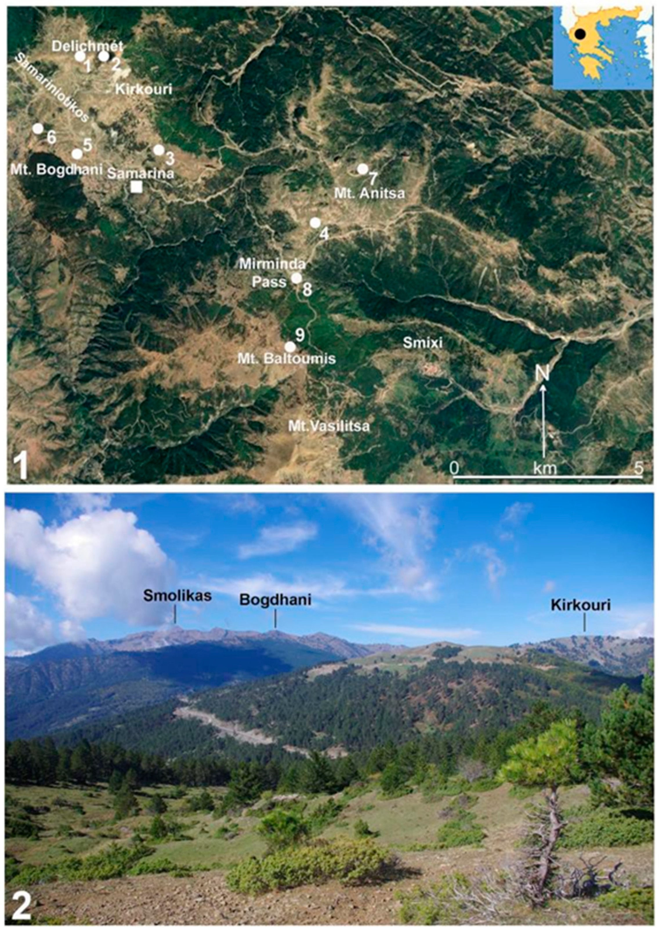
Figure 1. (1) Distribution map of the sites and some of the important localities reported in this paper: Delichmét (Sam-.5: n. 1), Kirkouri (KRK: n. 2), Holy Cross Church (SMC: n. 3), Avgo (VGO: n. 4), Historical Camp (HC: n. 5), saddle between Mts. Bogdhani and Gurguliu (n. 6), Mt. Anitsa (Anitsa: n. 7), Mirminda Pass (VLC: n. 8), and Mt. Vasilitsa (VSL: n. 9); (2) the watershed west of Samarina taken from the east close to the Mirminda Pass (map by E. Starnini; photograph by P. Biagi, 2014).
Heritage 08 00500 g001
Figure 2. Sam-5: Location of the trial trench opened below Mt. Delichmét (1), the small Byzantine hearth during excavation (2), and the double-pierced ceramic lug (3) (photographs by P. Biagi, 2004).
Heritage 08 00500 g002
Figure 3. Corrals (stânis) around Samarina, some of which are old stone-walled constructions (Avgo, (1) and Umbrela, (2)), one of which is somewhat old and partly still in use (Armaki, (3)), and one of which is a new wooden structure (Kirkouri, (4)) (photographs by P. Biagi, 2017 and 2018, nn. 1, 2 and 4 and R. Nisbet, 2014, n. 3).
Heritage 08 00500 g003
Figure 5. The Delichmét Watershed, east of the Samariniotikos River Valley and Samarina, with some of the locations discussed in the text. Note the treeless landscape due to intensive human activity, hundreds of years of deforestation, and seasonal grazing (photographs by P. Biagi, 2014).
Heritage 08 00500 g005
Figure 6. Roman Imperial age bronze coin (diassarion) from Mt. Anitsa (1) and two better preserved examples of diassarion as parallels for our specimen (2,3) (photographs by E. Starnini).
Heritage 08 00500 g006
Figure 8. (1) Mt. Gurguliu: Location of the ore melting site GRG-1 (white dot) and of the 9th century AD “Slavic Ware” potsherds (white square); (2) the GRG-1 site (photograph by P. Biagi, 2008).
Heritage 08 00500 g008
Figure 15. Vasilitsa Pass: Subrecent iron nail with flat, rectangular head and squared cross-section shaft, 270 mm long (photograph by V. Merlini).
Heritage 08 00500 g015
Disclaimer/Publisher’s Note: The statements, opinions and data contained in all publications are solely those of the individual author(s) and contributor(s) and not of MDPI and/or the editor(s). MDPI and/or the editor(s) disclaim responsibility for any injury to people or property resulting from any ideas, methods, instructions or products referred to in the content.