Article

Spatial, Functional, and Constructive Analysis of the Water Resource at the Archaeological Center of Tipon, Cusco, Peru, 2023

1
Faculty of Architecture and Urbanism, Ricardo Palma University (URP), Santiago de Surco, Lima 15039, Peru
2
Research Laboratory for Formative Investigation and Architectural Innovation (LABIFIARQ), Ricardo Palma University (URP), Santiago de Surco, Lima 15039, Peru
3
Faculty of Geographical, Environmental and Ecotourism Engineering, Federico Villarreal National University UNFV, Cercado de Lima, Lima 15082, Peru
4
Faculty of Architecture, Federico Villarreal National University UNFV, Jesus Maria, Lima 15072, Peru
5
Faculty of Obstetrics, National University San Luis Gonzaga (UNICA), Ica 11001, Peru
*
Author to whom correspondence should be addressed.
Heritage 2024, 7(12), 6629-6656; https://doi.org/10.3390/heritage7120307
Submission received: 9 September 2024 / Revised: 4 November 2024 / Accepted: 6 November 2024 / Published: 26 November 2024
(This article belongs to the Section Archaeological Heritage)

Abstract

The objective of this research is to analyze the spatial, functional, and constructive aspects of the water resource at the Archaeological Center of Tipon, given the lack of awareness towards the timely preservation of archaeological heritage, the deterioration of the terraces, and the contamination of the rivers adjacent to the archaeological site due to the discharge of waste into the water bodies. The methodology employed consists of a site study analysis, considering data on terrain, environment, climate, and water flow in the spatial, functional, and constructive aspects, supported by digital tools (Google Earth Pro 2024, AutoCAD 2024, SketchUP 2024, Sun Path 3D 2024, Photoshop 2024, and Twinmotion 2024). The results yielded a spatial–functional–constructive hydrological analysis; the water flow, constructed underground through a masonry system with an approximate angle of 60° in stone or pink granite, also maintained a negative slope, generally between 1% and 3%, which facilitated a rapid and direct distribution, presenting a greater flow with a width and depth of 30 cm, in addition to a vertical drop of 240 cm. The efficient use of water in agriculture through interconnected terraces ensured the population’s sustenance by approximately 80%. In conclusion, the analysis not only provides information on the infrastructure and water management but also addresses current issues.

1. Introduction

Water has played a fundamental role throughout the history of humanity, being essential for the survival and development of civilizations. It is one of the most important resources, along with soil, air, minerals, and energy, serving multiple vital roles in various aspects, from daily and domestic use to environmental balance and industrial applications [1].
Since ancient times, different cultures have understood the vital importance of water, establishing their settlements near abundant water sources, such as rivers and lakes, which provided water for irrigation and consumption [2,3] by civilizations, such as the Sumerians, Egyptians, and Romans, based their socio-economic evolution on the intelligent use of water, creating canal systems, reservoirs, and advanced hydraulic techniques that influenced their development [3]. Moreover, water has been a significant cultural element, influencing daily life, architecture, art, and literature in societies throughout history [4,5].
In more recent times, the relationship between water and humanity has evolved, with an increasing focus on preservation, sustainable use, and proper management of this vital resource [6]. Water scarcity, pollution of clean water sources, and climate change have elevated the value of water, leading it to be referred to as “blue gold”. Some propose the commercialization of water and even its trading on exchanges, reflecting the growing awareness of the strategic importance of this resource. History shows that water has been a decisive factor in the evolution of civilizations and remains a crucial issue today for ensuring sustainability and the well-being of humanity [7].
Figure 1 shows the most important rivers in the world, such as the Amazon (A), located in South America; the Mississippi (C), which is in the United States and flows from north to south through the country; the Nile (F), located in northeastern Africa and flowing into the Mediterranean Sea; the Yenisei (H), which originates in Mongolia, crosses Russia, and empties into the Kara Sea; and, lastly, the Yangtze (I), situated in the eastern part of Asia, primarily within China [8]. These rivers hold significant cultural, economic, and ecological importance, providing water, agricultural, and energy resources to the communities living along their banks. They are areas of incredible biodiversity, hosting a wide variety of flora and fauna, and are also among the longest and most voluminous rivers in the world [8].
Historically, hydraulic centers covered large areas with irrigation systems, often combined with dryland agriculture, which relied solely on rainwater and did not involve human intervention [9]. Water resources are fundamental for developing societies, as they are essential for human survival, agricultural production, hydroelectric energy, sanitation, industry, tourism, mining, culture and tradition, the economy, and sustainable development. However, hydraulic stagnation has been observed, leading to regression in some societies [9]. This phenomenon was seen on a large scale in the Old World. These societies impacted the efficiency of hydraulic systems over long periods, especially during the first millennium AD, and significantly impacted the management and efficiency of hydraulic systems, which may have led to difficulties in the operation and maintenance of these infrastructures over time [10,11]. Hydraulic centers in antiquity offered significant advantages in terms of efficient water management, increased agricultural productivity, mechanical energy generation, and demonstrated sustainability and durability over time [12]. Rivers are essential for biodiversity, the economy, and the history of the communities that have settled along their courses. South America has the highest number of major rivers, among which the Amazon River stands out, bordering six countries, including Peru [13].
Peru has a wide variety of water resources, with the Amazon Basin standing out for having the largest water availability in the world. Within its territory, there are more than 1000 rivers of varying lengths and water volumes (discharge), but 107 are the most representative basins [14].
Figure 2 shows the rivers in Peru and their respective lengths. This map shows that the longest rivers in Peru are the Amazon, Maranon (Marañón), and Ucayali [15]. (F) shows the Amazon River, which originates in Peru. It is the most voluminous river in the country and the world, with a length of 6400 km. Its tributaries include the Maranon River (G), with a height of 1737 km, and the Ucayali River (H), with a height of 1791 km, the latter being the primary headwater of the Amazon River [15]. Similarly, the main tributaries of the Ucayali River are the Urubamba River and the Tambo-Ene-Apurimac, whose headwaters are located above 5000 m.a.s.l. [16]. Meanwhile, (I) shows the Apurimac River, which is situated in the canyon of the same name, 166 km from the city of Cusco, and is considered the source of the Amazon River [17].
The Apurimac River has a length of 731 km. It is an important water source for the hydraulic system of Tipon, as it emerges from an underground spring in the mountains that feeds the channel and aqueduct system of the archaeological site [18]. This irrigation system is an example of Inca hydraulic engineering, as it can transport water from natural springs to the terraces and platforms of the archaeological site. Moreover, the irrigation system of Tipon represents a symbiotic relationship between humans and water in the Inca culture, as the water was revered as a sacred element and used in ceremonial rituals [18], as shown in Figure 3.
In Cusco, the ancient hydraulic systems of sites like Ollantaytambo, Moray, and Tipon stand out for their sophistication in water resource management and their direct relationship with terrace agriculture. In Ollantaytambo, the hydraulic system ensured efficient irrigation for agricultural terraces, which were fed by the Patakancha River, while also preventing soil erosion, thereby securing long-term agricultural sustainability. The terraces, located on the mountainsides, were designed to take advantage of the natural slopes of the terrain, allowing water to flow smoothly from springs to different levels, maximizing the use of space and water in challenging geographical conditions [19].
In Moray, the Incas implemented ingenious techniques for capturing and storing rainwater and snowmelt, which supplied the circular terraces arranged in an amphitheater-like layout. These terraces, built at different depths and heights, created unique microclimates where the temperature could vary significantly between the upper and lower levels. This design allowed the Incas to cultivate a wide variety of crops, such as maize, quinoa, and tubers, under controlled conditions that replicated different climates from across the empire. The terraces not only served an agricultural function but also acted as a natural laboratory for experimenting with crops, optimizing the adaptation of plants to various environmental conditions. This clever adaptation ensured agricultural productivity in a region with marked climatic fluctuations, enabling the Incas to maximize production and efficiently manage water and agricultural resources in the area [20], as shown in Figure 4.
The ancestral archaeological center of Tipon, located in the District of Oropesa, Province of Quispicanchis, Department of Cusco, at an altitude of 3400 m.a.s.l., is a prominent example of advanced Inca hydraulic engineering [21]. The name “Tipón” in Quechua, likely derived from tipuy (“boiling”) and timpuy (“to travel”), reflects the continuous movement and vitality of water, central elements in Inca culture and spirituality [22]. This archaeological site is notable for its intricate systems of channels and fountains, where water flows in a controlled manner, giving the impression of having its own “life”. In Tipon, water was not only used for agricultural irrigation but also for ceremonies that honored its sacred role as a source of fertility and as a link between humans and Pachamama or Mother Earth. For the Incas, water was much more than a resource; it was a symbol of continuity and a sacred element that deserved respect and veneration. Tipon, in its design, unifies the functional with the symbolic, showcasing how the Incas combined their technical skills with a deep spirituality, reflected in the way they directed and celebrated water as a vital and divine resource. This complex has been recognized by the American Society of Civil Engineers as a marvel of civil engineering, highlighting the technical prowess of the Incas in water management [23].
Tipon is characterized by its sophisticated network of channels, terraces, and platforms designed to optimize water use in agriculture. These structures facilitate efficient water distribution across the terrain, transporting it from natural springs to cultivated areas [18]. This ingenious system reflects not only the engineering capabilities of the Incas but also their profound respect for the natural environment.
Water, in addition to being a vital resource, held a sacred role in Inca culture and was utilized in ceremonial rituals at the fountains of Tipon [24]. In these spaces, water was revered, symbolizing its importance in agriculture and the spiritual life of the Incas. Thus, water was not only essential for agricultural production but also integrated into their beliefs and daily practices.
The hydraulic infrastructure of Tipon stands as a model of sustainable engineering, combining functionality with respect for natural resources. This legacy underscores the interconnection between the technical skills of the Incas and their Andean worldview, demonstrating how they harmonized their practical knowledge with the surrounding environment.
Figure 5 shows the elements of the Tipon hydraulic center. In Figure 5A, the thirteen terraces around the complex are generally visible, which likely served as an agricultural experimentation center, utilizing the different ecological levels. Similarly, in Figure 5B, the main spring with four slopes and water channels is shown, demonstrating the advanced hydraulic technology of the Incas, showing the head of Tipon: gathering pool, aerators, and rectangular screen spillway [25,26]. It can also be seen in Figure 5C, which shows one of the stone-carved channels that are precisely engineered and are an essential part of the advanced hydraulic technology of the Incas at Tipon [27]. Finally, in Figure 5D, the protruding stairs are shown, allowing movement between the terraces and platforms. These stairs can be single or double-flight, and some are perimeter.
Similarly, the site is significant for its terraces bordered by stone walls [21]. At the top of the Tipon terraces, there is an underground well that feeds the intricate system of waterways. All the terraces have an ingenious system of channels that directs water to different levels during the dry seasons and is an efficient drainage system during heavy rains [18].
However, the Tipon Hydraulic Center is facing the effects of the high number of tourists it receives, leading to the erosion of paths and surrounding areas due to the constant foot traffic of visitors. Additionally, the services provided around tourism by travel agencies cause surface soil erosion, deforestation, air pollution, and alteration of visual quality [21].
In Figure 6, Figure 6A illustrates how the paved road providing access to the Tipon Archaeological Park was completely blocked due to a landslide of earth and rocks [28]. Meanwhile, Figure 6B displays the restoration of a 2 km section of the Inca Trail, where retaining walls have been implemented to stabilize the terrain, which presents fractured rocks at risk of falling [29]. These landslides and the necessity for retaining walls are primarily attributed to the intense rainfall in the region, which erodes the mortar of the masonry structures and impacts the stability of the walls. The accumulation of rainwater, without adequate drainage, leads to soil erosion and increases the risk of landslides [18].
Additionally, the contamination of the rivers adjacent to the Tipon archaeological site, such as the Huatanay River, poses a significant problem. This contamination occurs as a result of the discharge of liquid, solid, or gaseous waste into the water bodies, which can alter their optimal state and affect their quality and availability [30].
Therefore, this research aims to analyze the spatial, functional, and constructive aspects of the water resources at the Archaeological Center of Tipon, Cusco, Peru, 2023.

2. Materials and Methods

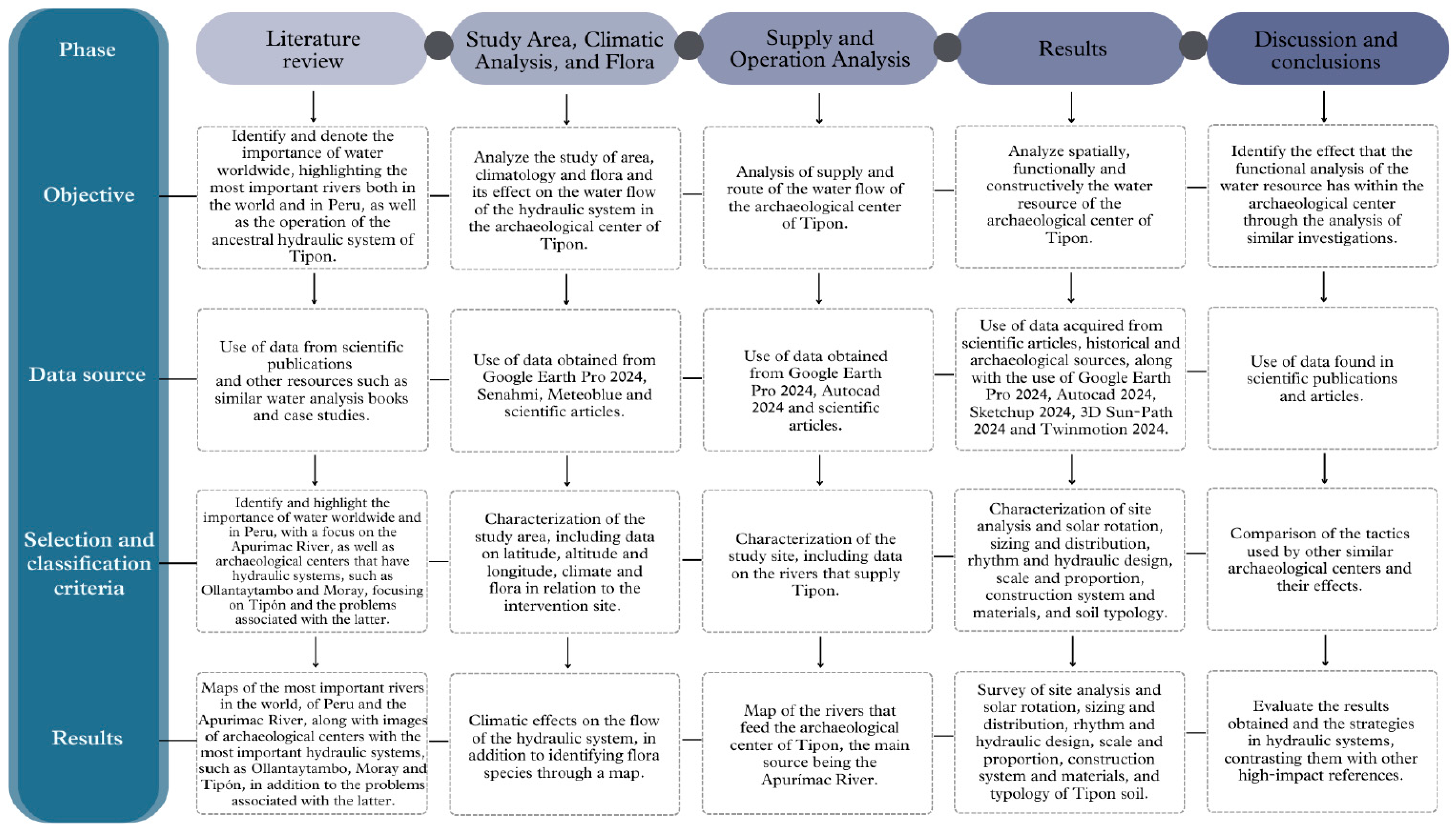
2.1. Methodological Scheme

The study was divided into five phases, as shown in Figure 7, and was conducted according to the following sections.

2.1.1. Literature Review

In the first phase of the study, a comprehensive review of the literature was conducted to contextualize the spatial, functional, and constructive analysis of the hydraulic center of Tipon. This process allows for the gathering of key information regarding Inca hydraulic architecture, water resource management, and community and ritual practices associated with these systems. The reviewed sources include academic research on Inca hydraulic engineering, archaeological studies examining the Inca worldview regarding water, and scientific publications from national and international organizations specialized in cultural heritage conservation. This review was crucial as it enabled the identification of design and construction principles applied by the Incas in Tipon, the geological and climatic aspects influencing its planning, and the significance of spatial and communal functions. It also helped establish parameters for understanding architecture, water management, and the integration of the natural landscape within the Andean context.

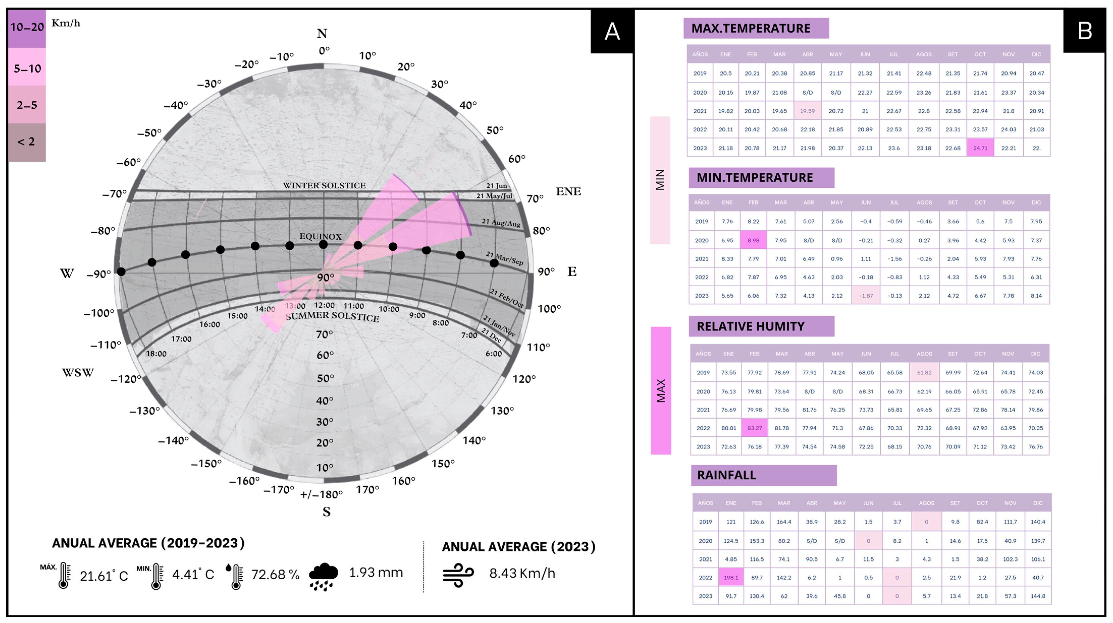
2.1.2. Study Area, Climatic Analysis, and Flora

Site analysis is a fundamental tool for identifying site characteristics, as it allows for the determination of the location, latitude, and longitude of the intervention area, which, in turn, helps to understand the natural environment [31].
Tools like Google Earth Pro 2024, which allows for the precise location of the archaeological center, detailed exploration of specific areas, distance and area measurements, and coordinate calculations, can help one better understand space. Academic documents, archaeological research, and engineering studies provide detailed data on location, history, architectural features, hydraulic systems, and construction materials.
Climatic analysis is essential for assessing groundwater quality and providing information on aquifer recharge and its quality and availability [32]. This is useful for evaluating the system’s sustainability, understanding the impacts of climate change, and providing historical context on the management of ancient communities under different conditions [32].
This procedure involves a climatological study encompassing maximum and minimum temperature, wind speed, relative humidity, and precipitation. The process is detailed as follows:
  • Collection of hydrometeorological data from SENAMHI for the Granja Kayra meteorological station for the past five years (2019–2023), including maximum and minimum temperatures (°C), relative humidity (%), and precipitation (mm);
  • Gathering meteorological data from MeteoBlue EPW for the year 2024, including wind (Kmh);
  • Thorough statistical analysis of the collected data;
  • Creation of graphs displaying data for the parameters outlined in points 1 and 2.
The analysis of flora in ancient times provides valuable information about the environment, hydraulic systems, soil, and groundwater of the area. This helps to understand the agricultural history of the region, historical crops, ancient cultivation practices, and water adaptation and management.

2.1.3. Supply and Operation Analysis

The initial stage of hydrographic analysis involves accurately identifying the location of the study area, supported by detailed cartographic maps. This offers a comprehensive view of the geographical arrangement of the rivers in each region and their connection to the ancient hydraulic system of Tipon. Following this, a thorough analysis of the hydrographic basins in each area is conducted, focusing on critical elements such as their length and flow direction and the geological characteristics that define them. Additionally, an in-depth examination of the river flow that supplies the Tipon archaeological site is performed, which aids in better understanding its impact on the local water supply and, ultimately, the operation and significance of the ancestral hydraulic system within its geographical context.

2.1.4. Results

Site Analysis and Solar Rotation: This stage involves a detailed evaluation of the interaction between radiation and the intervention area, considering factors such as geographic location, topography, and the orientation of structures. This analysis is essential for architectural planning and energy resource management.
Spatial Analysis: This stage involves gathering historical and archaeological information through a study of the terrain using topographical analysis to understand the area and process the data obtained on the slopes of the terrace levels. Additionally, a detailed analysis of the water distribution in 2D is conducted, using plan and section views of the study area; at the same time, the dimensions of the system in elevations are determined through a 3D survey to understand its spatial functionality. An analysis of the rhythm and hydraulic design of the channels in the site is also carried out, along with observing their scale and proportion. The information obtained is crucial in assessing the efficiency and capacity of the water supply through an evaluation of the study area, which is essential for understanding the structure and functioning of the hydraulic system and evaluating its capacity and efficiency in water distribution. Moreover, it allows for identifying the geographical and archaeological characteristics of the terrain, which is fundamental for planning interventions and ensuring the proper water supply in the study area.
Functional Analysis: In this stage, the functionality of the water system is investigated through a study of the distribution area and flow rate sizing using Google Earth Pro 2024, considering factors such as storage capacity, terrain slope, and the specific water needs of the region. Additionally, the possible water sources, the effects of precipitation, and the efficiency of collection and distribution systems are examined. To better understand the environment and its carrying capacity, the hierarchy of channels is detailed through an analysis of the activities conducted in the area. This method helps determine how water resources were distributed and how they affected the social and economic structure of the region, following a carefully designed route through channels and aqueducts that are part of a hydraulic system, allowing for efficient and precise water distribution and management on the site.
Constructive Analysis: This analysis studies the components, materials, and construction techniques used in the ancient hydraulic system. This includes identifying and describing elements such as channels and aqueducts, analyzing the materials used, such as stone, adobe, and others, investigating the construction techniques employed, and evaluating the durability of the structures. It also involves studying the different types of soils in the area to understand their influence on the hydraulic system’s design, construction, and functioning. This includes analyzing texture and structure, evaluating infiltration capacity, and conducting erosion studies. The information obtained helps to understand how the soil influences water distribution, the stability of structures, and other crucial aspects of water management in the historical context of Tipon.
The process of modeling the Tipon archaeological center includes detailing its geographic location and relief, which is represented in the three-dimensional model. Additionally, an analysis of its solar orientation is performed, supported by digital tools. The primary objective of this analysis is to consolidate information to identify how this hydraulic system is supplied and its functioning. This process involves essential steps to achieve a comprehensive analysis of the environment and water flow. The first step involves acquiring terrain data using Google Earth Pro 2024. This provides important information on three-dimensional visualizations and cross-sections of the environment. In Step 2, an in-depth study of the terrain is conducted using AutoCAD 2024, resulting in the delineation of the hydrographic networks. This stage also defines the boundaries of the study center. Step 3 updates a complex 3D model of the hydraulic system of the archaeological site using SketchUP 2024. Finally, in Step 4, a comprehensive 3D Sun-Path 2024 analysis is performed to assess the effects of sunlight on the terraces, walls, and channels of the system, as shown in Figure 8.

2.1.5. Discussion and Conclusions
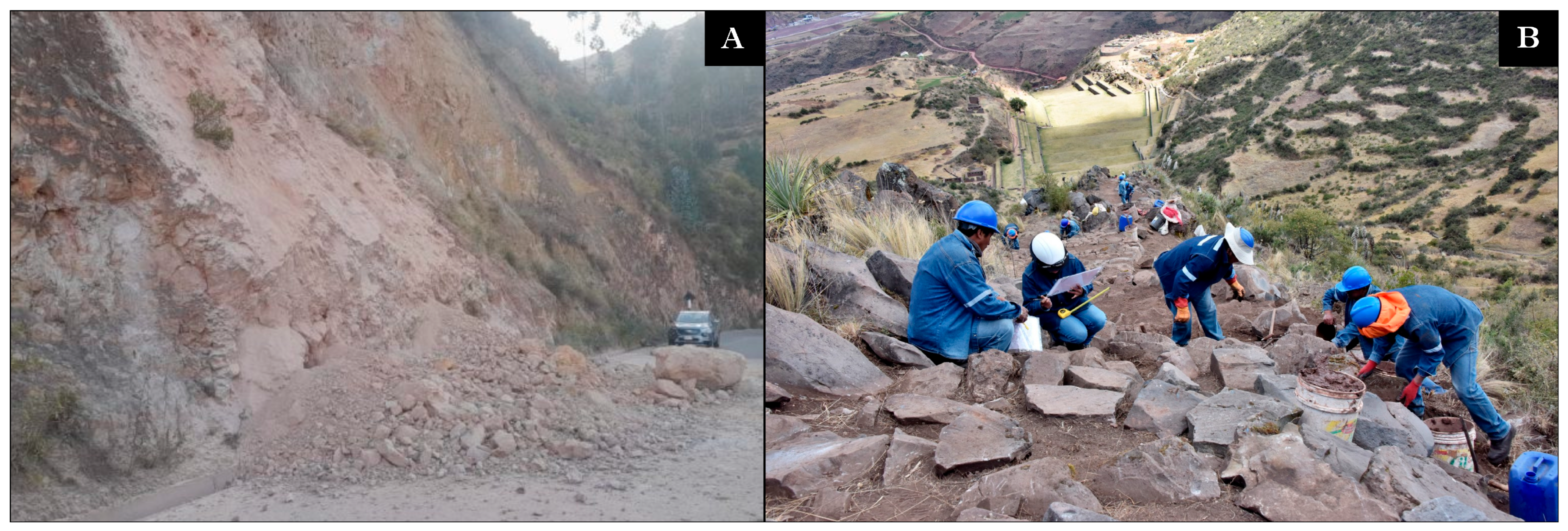
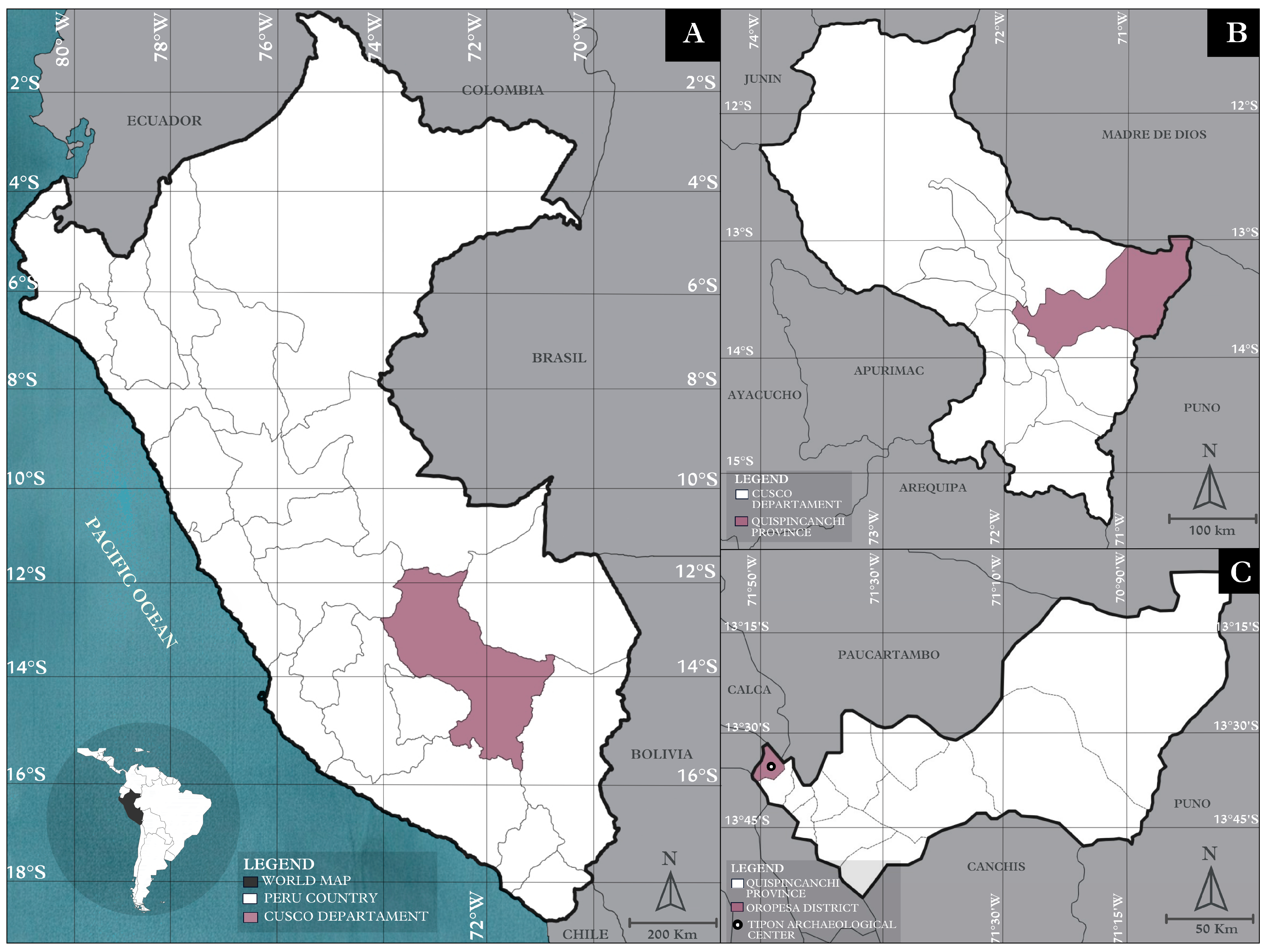
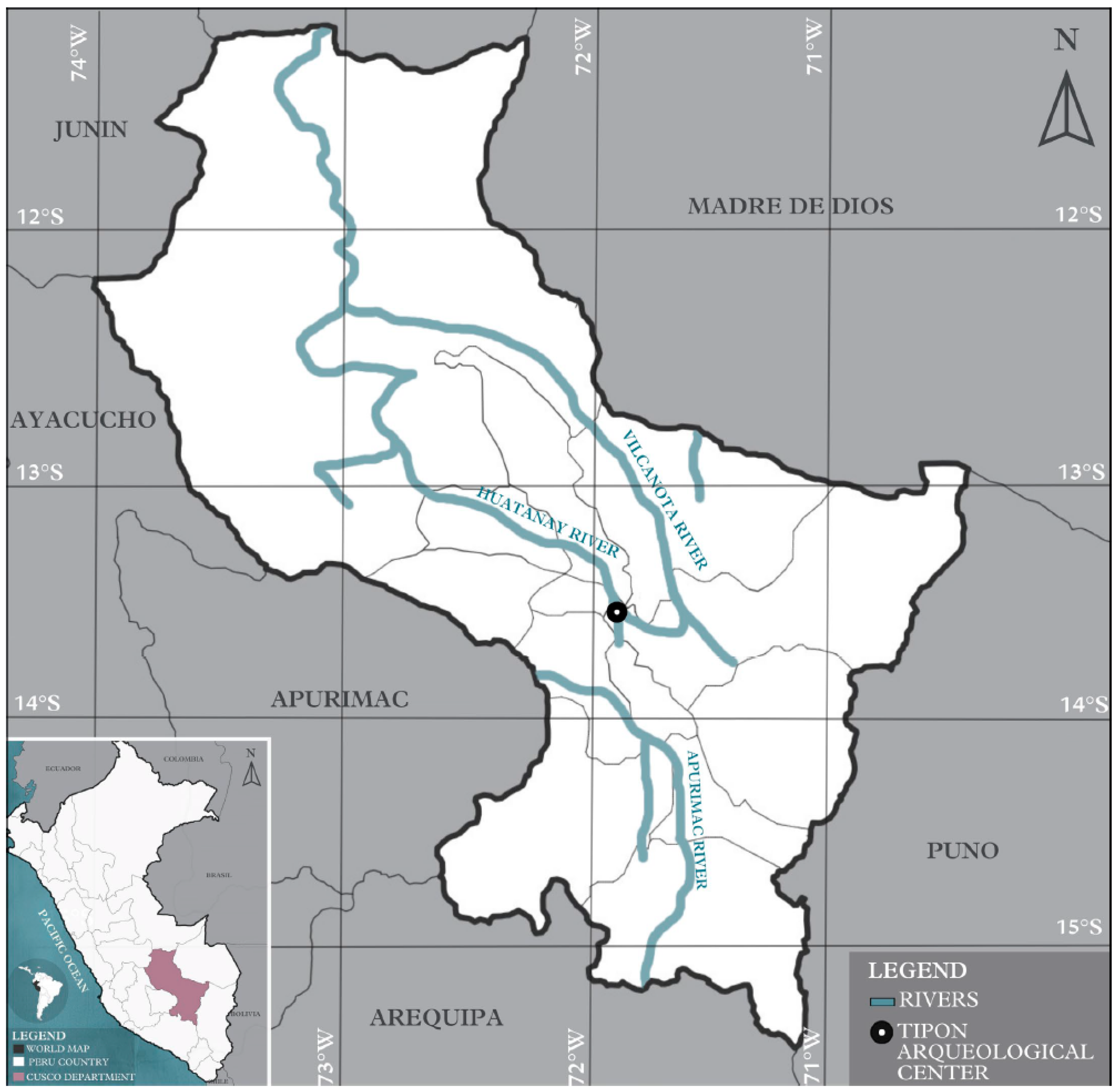
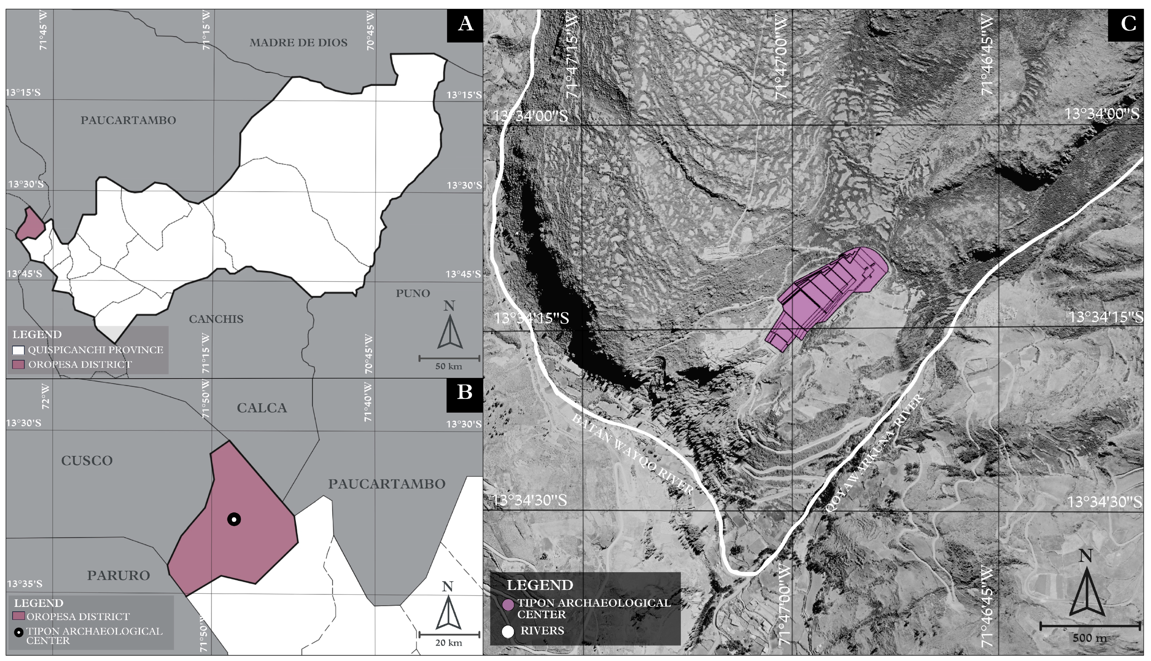
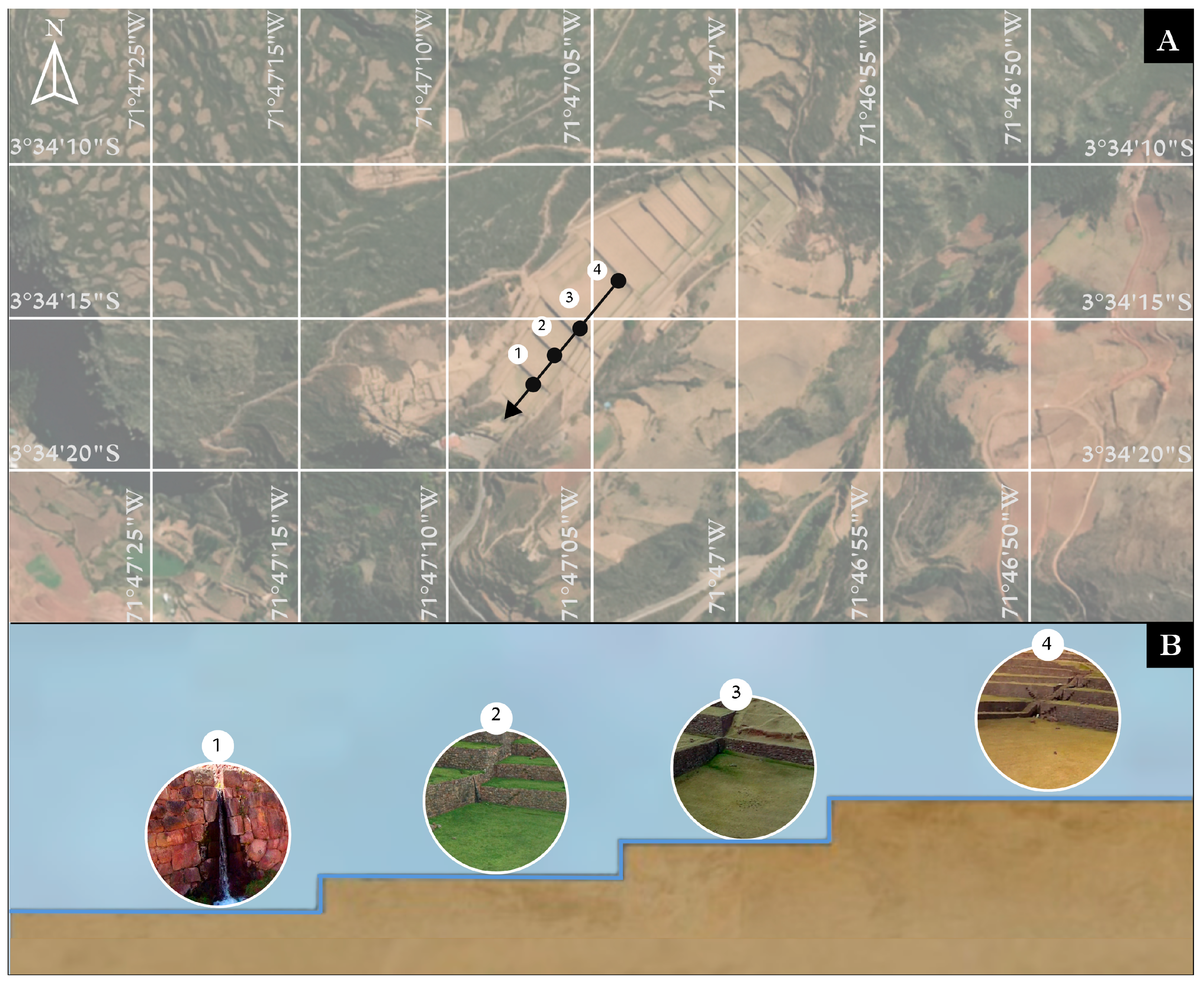
Finally, in the last stage of the study on Tipon, the findings are compared with previous references from other Inca archaeological sites, such as Ollantaytambo and Moray. This comparison allows for the evaluation of similarities and differences in design strategies and water management, highlighting the Incas’ capacity to adapt their hydraulic systems to diverse geographical and climatic conditions.

2.2. Study Area

In Figure 9, the location of the Tipon archaeological center is shown, which is situated in the Oropesa District, Quispicanchi Province, Cusco Region, Peru [33]. It is located approximately 17 km east of the city of Cusco, one of the country’s major cities and the former capital of the Inca Empire. This hydraulic center is part of the Sacred Valley of the Incas, a region rich in history and cultural heritage [33]. It is primarily fed by the nearby Huatanay, Vilcanota, and Apurimac rivers [21].

2.3. Climate Analysis

According to the climate classification by SENAMHI, Tipon exhibits a very temperate and semi-arid climate, C (o, i) B’, semi-arid with dry autumn and winter. Additionally, it is located in Zone 4, Mesoandino, according to the classification by the Ministry of Housing [34].
Cusco’s solar chart is shown in Figure 10. Tipon has a temperate and cool climate in the Andean landscape characterized by dry winters and mild summers. The annual average maximum temperature reaches up to 22.61 °C, while in the colder months from June to August, temperatures drop to −1 °C. The highest temperature recorded was in October 2023, reaching 24.71 °C, while the lowest maximum temperature occurred in April 2021. In 2023, the highest temperatures of the last five years were recorded, whereas 2022 experienced the lowest average temperatures at 4.15 °C. The highest minimum temperature was registered in February 2020, while the lowest minimum temperature was reached in June 2023. The temperature in the area provides an environment that supports the growth of native flora such as Puya herrerae, Polylepis incana, and Tecoma sambucifolia.
On the other hand, the annual average relative humidity is 72.86%, peaking around 79% and decreasing to an average of 67% between July and September. The minimum relative humidity was recorded in August 2019, while the maximum relative humidity was reached in February 2022. Precipitation increases significantly from December to March, with February experiencing the highest levels at 616.5 mm. However, due to climate change, precipitation markedly reduces from June to August, with an average of approximately 14 mm recorded [35].
Predominant winds come from the north, varying from NE to NW, with an average speed of 8.43 km/h. [36]. The maximum precipitation was recorded in 2022, while minimum precipitation was observed in all studied years during the months of June, July, and August.

2.4. Flora

The flora near the archaeological center of Tipon is observed. There is a variety of endemic plant species that demonstrate the diversity present at the site [37]. The site’s vegetation features a diverse range of native wild plants, including Puya herrera, Cantua buxifolia (kantu), Colletia spinosa (rocke), and Polylepis incana (quena), as well as seasonal crops such as potatoes, wheat, and barley [37]. However, it faces serious challenges such as the overexploitation of plant resources, intensive grazing, frequent burning practices carried out by local inhabitants, habitat degradation, and the effects of climate change. These practices and phenomena threaten biodiversity and compromise the stability of ecosystems in the area [38], as shown in Figure 11.

2.5. Supply and Operation Analysis
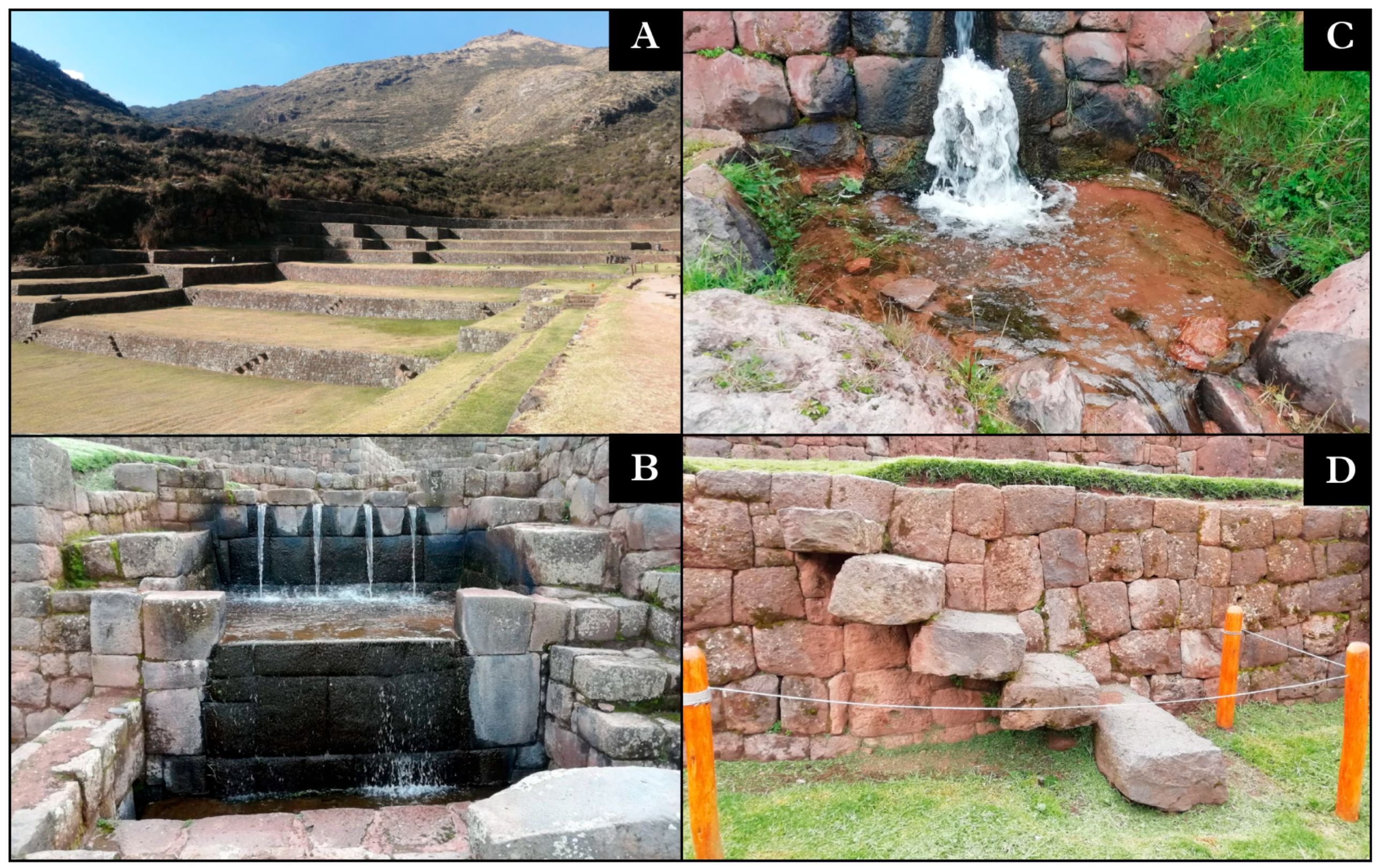
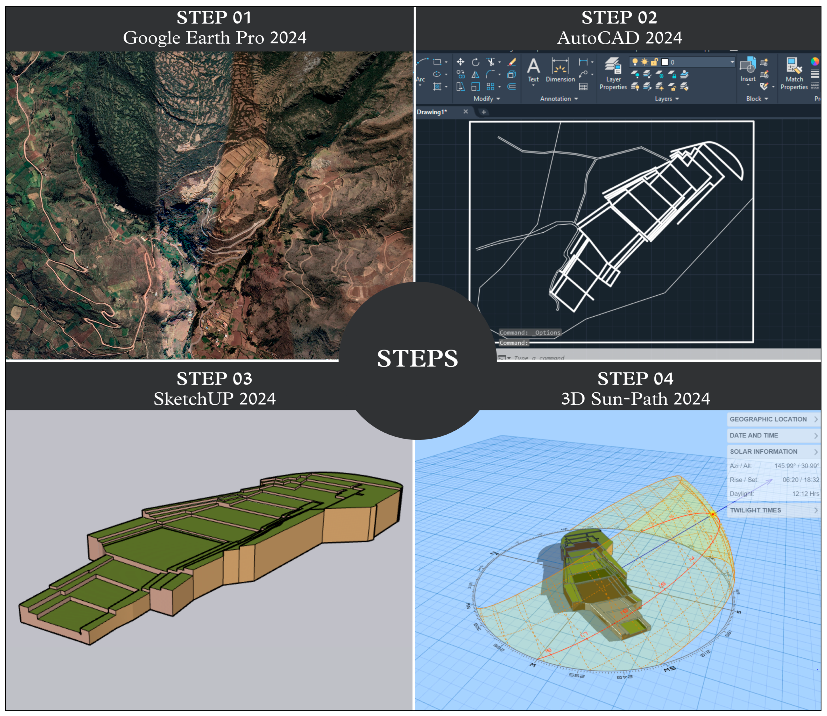
Tipon is primarily fed by the Huatanay River, with its tributaries Vilcanota and Apurimac, a significant water source that supplies the channel and aqueduct system of the study site [18]. It is crucial to note that there is a contamination sequence in the Huatanay River due to the discharge of waste, which subsequently affects the Vilcanota River. This situation poses a significant risk to water quality, impacting local flora and fauna, as well as agricultural activities and water supply. Furthermore, it jeopardizes the ecological balance that the Incas sought to maintain within their hydraulic system [30]. The Huatanay River has a length of 38 km and a flow rate of 100 m3/s [30], flows through the inter-Andean valley, and supplies the city of Cusco before flowing into the Vilcanota [30], as shown in Figure 12.
The Vilcanota River, extending 862 km with a flow rate of 2330 m3/s, originates in the Vilcanota mountain range and flows northwest. As it descends, it takes the name Urubamba and eventually joins the Tambo River to form the Ucayali River [39]. For its part, the Apurimac River, another important watercourse in the region, originates in the Vilcabamba mountain range at an elevation of 5597 m.a.s.l. and flows north and northwest through the Peruvian Andes. With an approximate length of 42 km and a flow rate of around 318.13 m3/s, the Apurimac is vital for water supply in the south-central region of Peru. Additionally, its underground origin in certain sections makes it a crucial source for hydraulic systems such as that of Tipon, where its waters feed a network of channels and aqueducts designed by the Incas for agricultural irrigation [17].
Tipon, with its network of channels and agricultural terraces, efficiently harnesses water for agriculture. This ability to control and direct water flow allowed the Incas to thrive in the steep mountainous region, ensuring the sustenance of the population and contributing to the development of their civilization [18].

3. Results

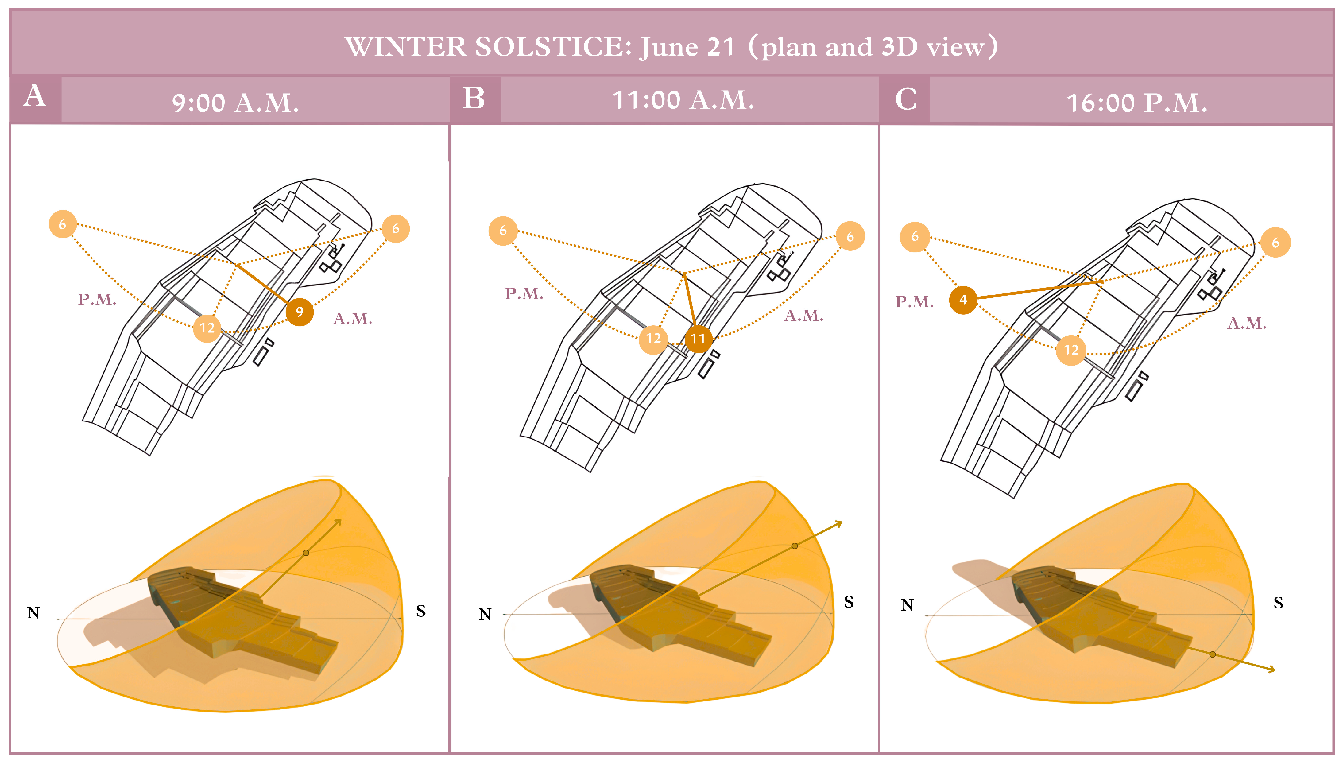
3.1. Site Analysis and Solar Rotation

The Tipon hydraulic system is located in the Sacred Valley of the Incas, 23 km southeast of Cusco, at an altitude of 3560 m.a.s.l., with coordinates of latitude −13.57083333 and longitude −71.78305556 [40], as shown in Figure 13.
Tipon stands as an exemplary illustration of how the Incas integrated their astronomical knowledge with hydraulic engineering and agriculture. This understanding enabled them to maintain an accurate calendar, which was essential not only for the celebration of ceremonies such as Inti Raymi but also for determining the optimal moments for planting and harvesting essential crops [41].
In Tipon, the water channels are designed not only for the efficient distribution of this vital resource but also to align with astronomical events such as the winter solstice. During this event, the sun reaches its lowest position in the sky, and its light directly strikes specific points of the channel system, reflecting meticulous planning by Inca engineers [25]. The winter solstice marked the shortest day of the year and the beginning of a new solar cycle, coinciding with the celebration of Inti Raymi, a festival honoring the sun god, Inti [42].
This design demonstrates the Incas’ ability to harmonize functional and symbolic aspects in the construction of hydraulic systems, creating enduring structures that addressed both practical needs and astronomical principles [25].
In Figure 14, Figure 14A illustrates the sun at 9 a.m.; during the summer solstice in the Southern Hemisphere, the sun is positioned relatively high in the sky, casting short shadows directed towards the west–southwest. This phenomenon not only influenced the projection of shadows but also enabled the Incas to optimize solar exposure on agricultural terraces and irrigation channels. In Figure 14B, the sun’s direct incidence at 11 a.m. generates shadows extending westward, suggesting that this knowledge was instrumental in designing their structures and irrigation systems efficiently, ensuring that both terraces and channels received the optimal amount of sunlight necessary for agriculture and water management. Lastly, Figure 14C depicts the sun’s proximity to the horizon, resulting in elongated shadows that impact soil and plant temperatures, as well as the quantity of light received across various sections of the terraces. This astronomical knowledge empowered the Incas to manage water and sunlight effectively, creating microclimates within the terraces that fostered the growth of diverse crop types.

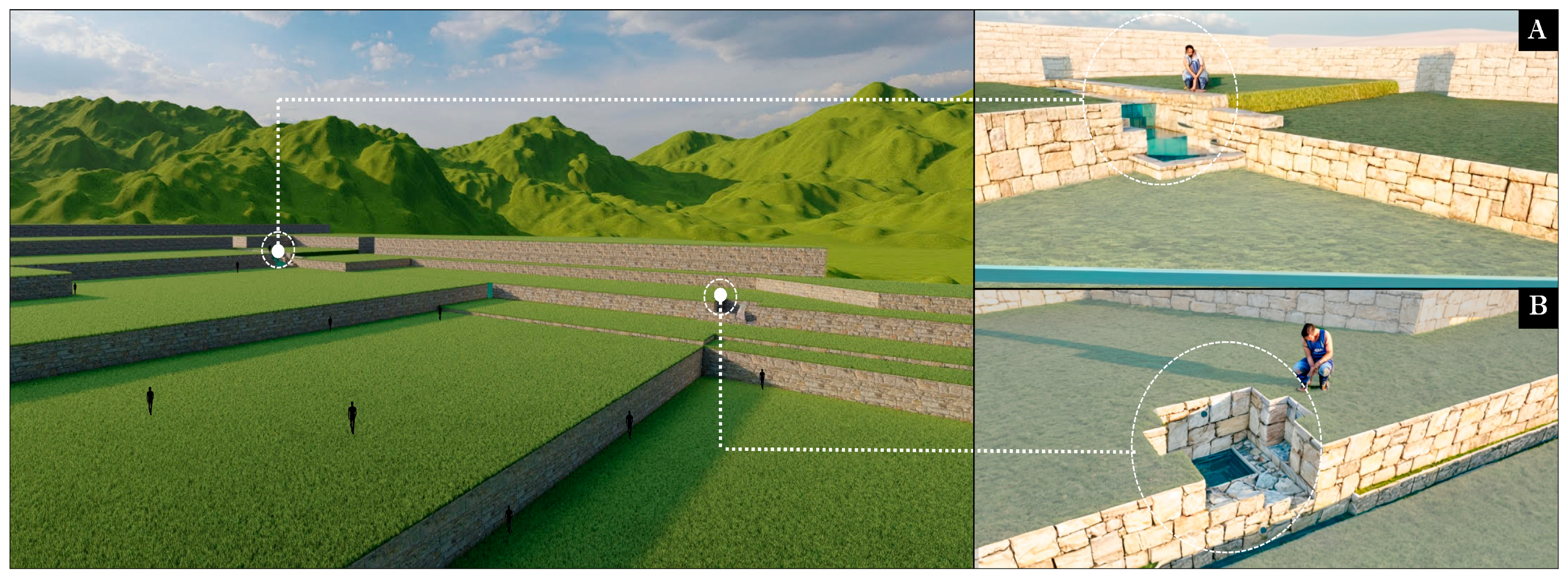
3.2. Spatial Analysis

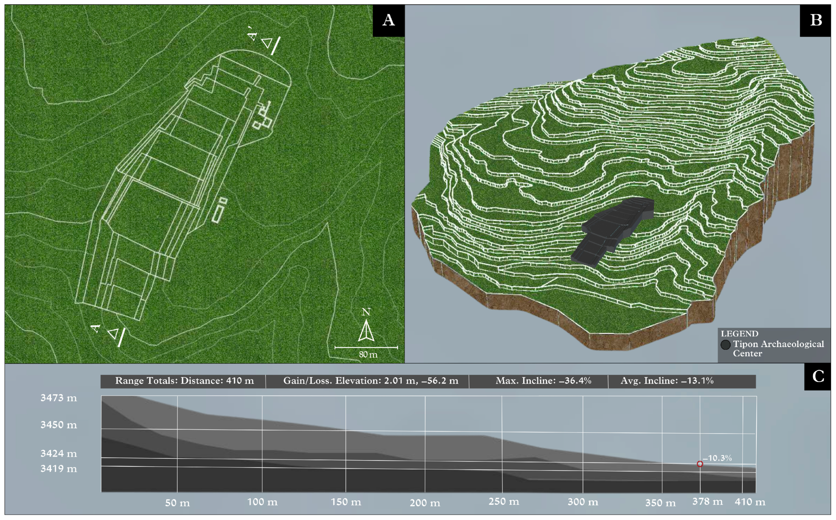
3.2.1. Topographic Analysis

The archaeological center of Tipon is characterized by its impressive topography, as it is built on steep slopes with a system of terraces and hydraulic channels that make the most of the rugged terrain [43]. The symmetry and precision of the stone construction are standout features of Inca engineering at this remarkable archaeological site [18].
Tipon was considered a connectivity route, as this archaeological center is located alongside the Inca Trail, facilitating access and transportation [44]. Additionally, it is directly related to agriculture and solar energy. The site’s position also determines the orientation of the water; since it is on a continuous slope, the sequence of water flow maintains a clear direction, fully supplying the archaeological complex [22].
Figure 15A shows the archaeological center of Tipon on a topographic map, providing a detailed view of the contour lines in the rugged terrain. Figure 15B displays the site in three dimensions, offering a better appreciation of the reliefs, elevations, and slopes. Finally, Figure 15C presents a topographic section that provides a detailed view of the terrain structure and composition, with the highest point at 3473 m and the lowest point at 3419 m, covering a total distance of 410 m. This section shows an elevation gain/loss of 2.01 m and −56.2 m, respectively, as well as a maximum slope of −36.4% and an average slope of −13.1% [40].

3.2.2. Sizing and Distribution of Flows

Figure 16A shows the distribution of the channels at the study site, their flow through the complex, and their strategic positioning for the correct supply to each area. Meanwhile, Figure 16B,C cross-sections illustrate the dimensions of a channel located on the second terrace, with a length of 30 cm, a width of 30 cm, a depth of 30 cm, and a drop of 243 cm. Channels in Tipon vary in size but typically have a width ranging from 30 to 60 cm [45]. They are designed with a gentle slope to ensure controlled water flow. The typical slope is about 1 to 3%, which prevents erosion and ensures uniform water distribution [45]. These structures served for water distribution and had ritual and aesthetic significance [23].

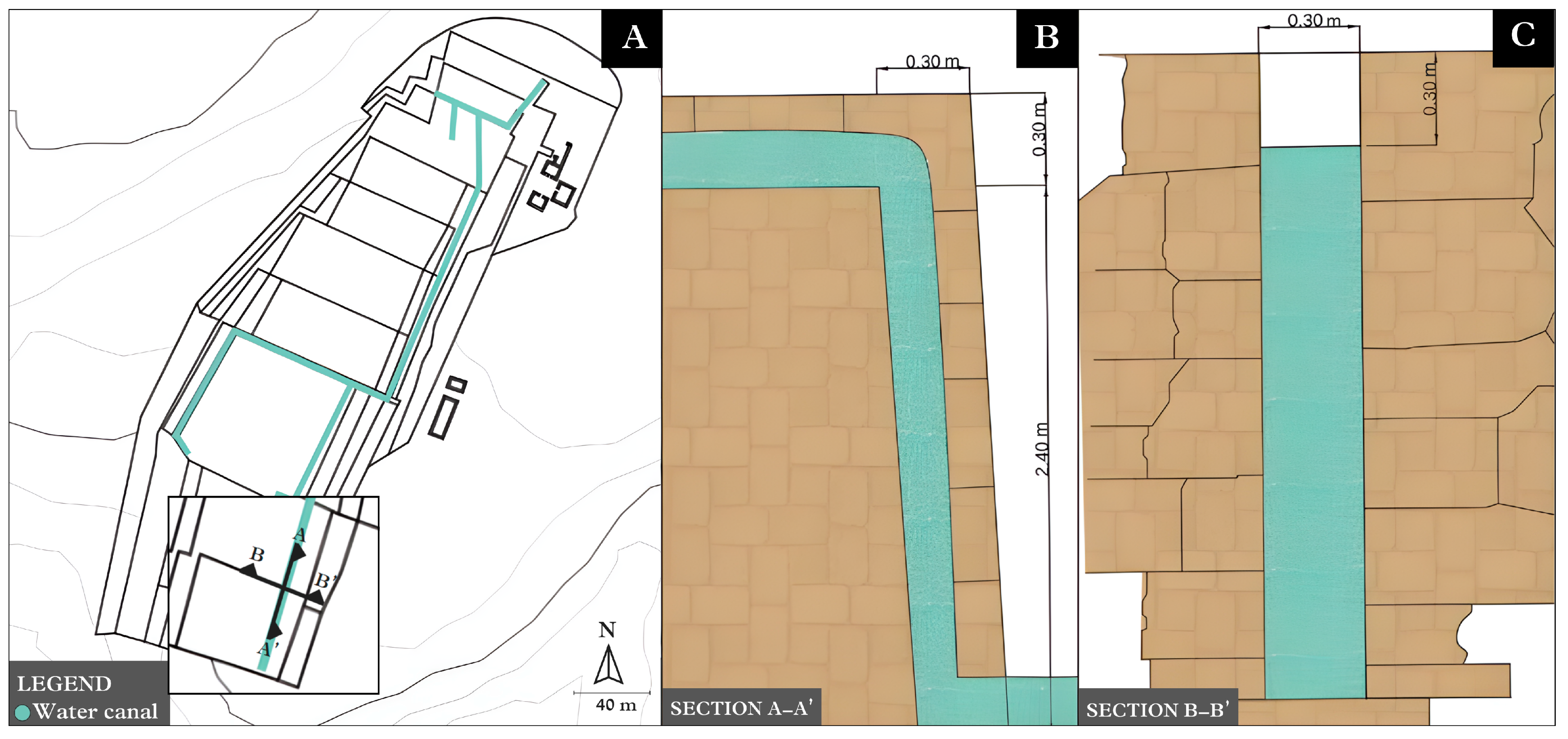
3.2.3. Hydraulic Rhythm and Design

The channels of Tipon are meticulously designed to facilitate a constant and uninterrupted flow of water. This is achieved through the construction of channels with precise inclinations tailored to the natural topography of the terrain, thereby enabling the continuous movement of water [18]. The circulation of water through the terraces follows a linear pattern, establishing it as a fundamental organizing element of the agricultural structure [46]. Furthermore, this linear design allows for the branching of channels, ensuring that water is not only distributed evenly across the terraces but also reaches additional areas, thereby optimizing irrigation throughout the region and contributing to successful agricultural production [33].
Moreover, the channels and terraces of Tipon adhere to a rhythmic repetition, organized in a reiterative manner with regular intervals adapted to the terrain’s topography, generating a visual and functional rhythm that guarantees the efficiency of the hydraulic system [46].
In Figure 17A presents the principal fountain, characterized by four springs. Numerous interpretations exist regarding these springs; they may symbolize the four suyos or the four Ayar brothers, who are recognized as the founders of the empire. It is noteworthy how these four springs maintained an equal velocity and rhythm for nearly 500 years following the conquest of the Inca Empire [47].
Transitioning to Figure 17B, the second principal fountain is illustrated, functioning as a secondary point for water evacuation while preserving an aura of authority, as it is framed by a clear entrance on its right side. As water progresses through the aqueducts, one arrives at Figure 17C, which showcases the water flow adjacent to the vertical circulation present on the fourth terrace. This exemplifies how the linear pattern of water flow facilitates the branching of channels, thereby optimizing irrigation for the terrace.

3.2.4. Scale and Proportion

The height of the terraces and fountains at Tipon was designed with consideration for accessibility and functionality for the people of that era, efficiently adapting to the topography of the terrain. However, upon conducting an analysis based on experiential insights, it can be concluded that individuals would reach approximately half the height of the terrace walls, which measure between 1 and 5 m, averaging around 2.5 to 3 m [45].
In this context, various research studies conducted over decades have provided greater precision regarding the average height of individuals during the Inca Empire. According to Maria Inés Barreto, men measured around 1.58 m, and women measured around 1.48 m in this period [48].
This 2:1 ratio between the height of the terraces and the average stature of the Incas generates a sense of shelter and security, allowing users to experience the space as inviting [46]. This proportion also enhances the perception of protection within the terrace area, reflecting a concern that is not only functional but also emotional in Inca architecture.
In Figure 18, Figure 18A,B show the proportion of a person standing next to the main fountain and the second central fountain, respectively. It is evident that the human figures reach approximately half the height of each terrace, highlighting not only the monumental scale of Inca architecture but also its intentional design.

3.3. Functional Analysis

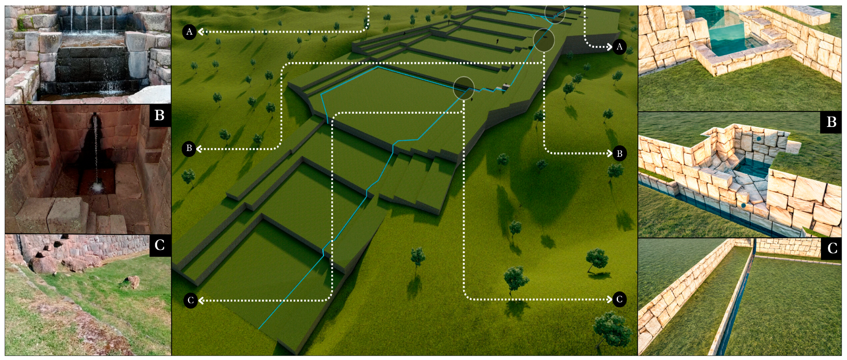
3.3.1. Analysis of Water Distribution and Sizing

The distribution of elements within the hydraulic system is specific and arranged in a pattern of terraces and channels that integrate harmoniously with the natural environment [49]. Sizing the components of the hydraulic system is crucial for understanding its operation and sustainability [26].
The hydraulic system of Tipon includes underground components such as springs and channels located beneath the surface. The spring on Terrace 13 produces an average flow rate of 15 L/s [45]. This spring is an underground water source emerging on the thirteenth terrace of the irrigation system at an altitude of 3450 m.a.s.l. and the surface source of the system is constituted by the Pukara River, which contributes an estimated flow rate of 21.5 L/s in the catchment area at 3690 m.a.s.l. [45].
Nonetheless, the pollution of rivers in proximity to the archaeological center of Tipon, such as the Huatanay, represents a significant concern [30]. The discharge of contaminating waste has the potential to degrade both the quality and availability of water, thereby threatening the integrity of the ecosystem as well as the preservation of cultural heritage. This situation undermines the effective functioning of the hydraulic system, which is essential for the maintenance of agricultural infrastructure.
Figure 19, in Figure 19A, shows an aerial view of the study site and its surroundings. Four areas of the archaeological site are identified as points of analysis, each highlighting the water drop present in them. In Figure 19B (1–4), the cross-section of the terrain is shown, illustrating the water flow path through the previously established areas.

3.3.2. Hierarchy

The hydraulic system of Tipon exhibits a hierarchical organization concerning the function of each channel, primarily due to the linear structure of water flow [46]. This organizational framework allows for the distribution of channels throughout the site’s expanse, assigning each a specific role within the overall system. As a result of this strategic arrangement, Tipon demonstrates precise and efficient control over water resources, optimizing crop growth and ensuring the food security of the Inca society. This highlights the intrinsic connection between hydraulic infrastructure and agriculture in sustaining the prosperity of the Inca civilization [18].
Furthermore, certain channels may have held ceremonial significance, as water was not only essential for agriculture but also played a pivotal role in rituals and religious ceremonies. This suggests that the hierarchy of channels in Tipon might have been conceived with symbolic purposes in mind, reflecting the importance of water in Inca cosmology [25].
In Figure 20, the hierarchy of Tipton’s channels is depicted. In Figure 20A, the main channels carry water from the primary sources and springs to the various terraces and sectors of the archaeological complex; these channels have a higher flow rate and a steeper gradient to ensure a constant water flow [33]. In Figure 20B, secondary channels distribute water to agricultural terraces and gardens; these channels have a lower flow rate and a gentler slope for more controlled irrigation [45]. Additionally, in Figure 20C, distribution channels within each terrace deliver water to different crops and irrigation areas; these channels have a more detailed design and an even gentler slope to ensure uniform water distribution [33]. Furthermore, Figure 20D shows irrigation channels constructed on slopes, which are infiltration trenches without gradients designed to capture runoff water and reduce erosion. These channels enable aquifer recharge and soil stabilization [18]; in the same way, Figure 20(1) shows a view from the second terrace, highlighting the constant hydric flow in an irrigation channel. Finally, Figure 20E presents drainage channels that prevent flooding and erosion; they collect excess water and direct it out of the complex. These channels have a steeper gradient to facilitate water flow [33]; Figure 20(2) shows a view from the fifth terrace towards the drainage channel.

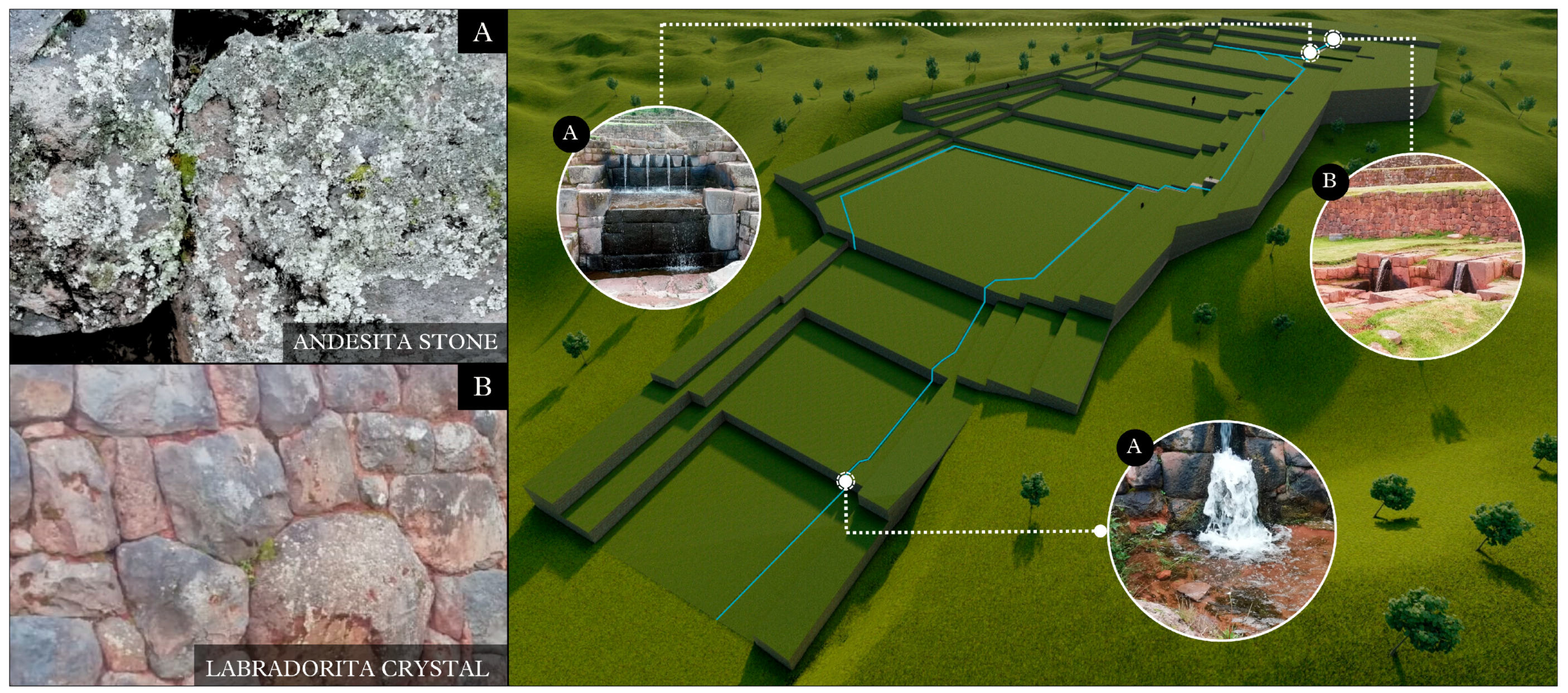
3.4. Constructive Analysis

3.4.1. Construction System and Materials

The construction system employed at the archaeological center of Tipon is characterized by masonry techniques featuring types of polygonal, quadrangular, and rectangular masonry, although in some instances, the walls consist of simple masonry [18]. The Incas primarily utilized volcanic rocks for the construction of their terraces and enclosures [25], employing large stones with diameters of up to 0.70 m, as well as medium-sized stones ranging from 0.35 to 0.40 m in diameter. The interlocking of these stones is accomplished through both concerted and simple masonry techniques [18].
These rocks, predominantly andesites, exhibit a composition rich in fine crystals of andesite and labradorite, indicating that the region is abundant in this type of volcanic material [25]. The presence of such rocks is attributed to the nearby Cruzmoqo hill, which is associated with an ancient monogenic volcano similar to the adjacent volcanoes of Rumicolca, Huacoto, Pinagua, Tongobamba, and Torrekunka [50]. Furthermore, the construction of the enclosures is closely linked to community practices such as the Mita and Minka. The Mita was a system of forced labor organized by the state, while the Minka promoted voluntary collaboration and community support. Both systems reflect fundamental aspects of Andean culture, emphasizing cooperation and collective well-being [51].
These construction systems and materials not only reflect the advanced engineering of the Incas in water management but also hold deep cultural and ceremonial significance [10]. Tipon stands as a testament to the skill and knowledge of this civilization in hydraulic architecture [10], as shown in Figure 21.

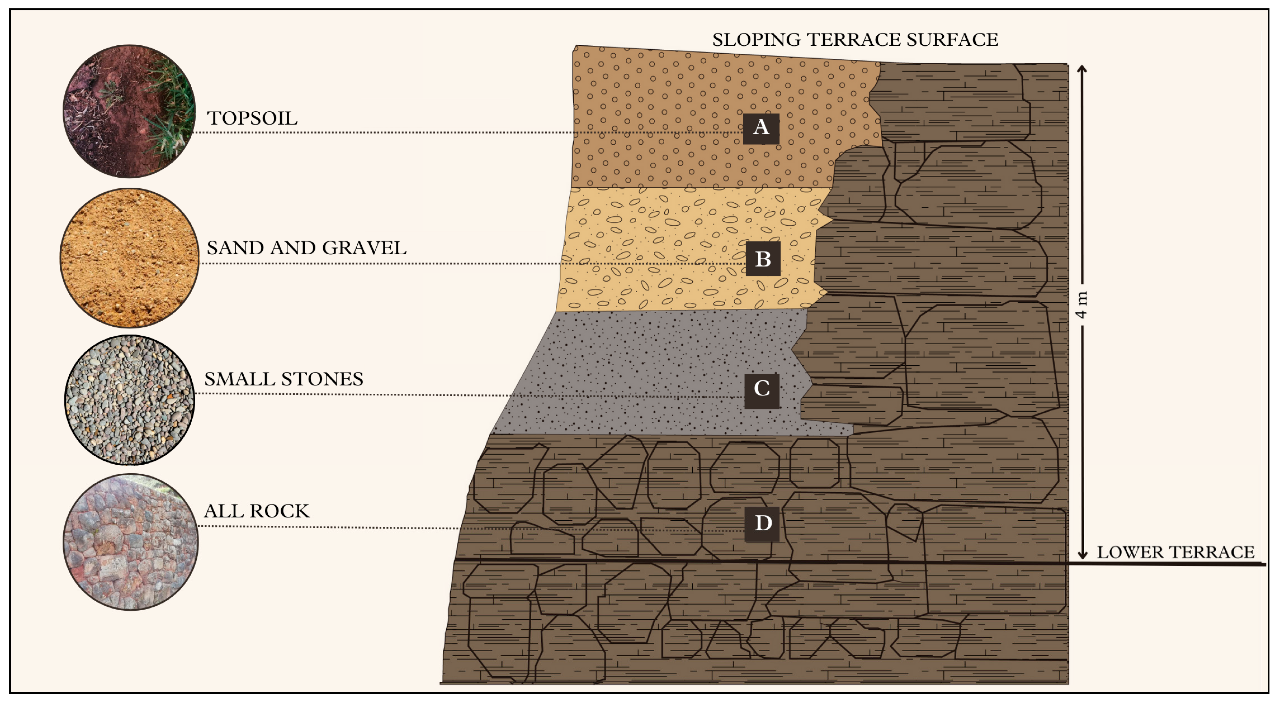
3.4.2. Soil Typology

Tipon features a range of soils that impact the installation and durability of ancient hydraulic systems, including sandy soils, which are prevalent in this region and are characterized by their delicate and smooth texture. Although they have low water retention, their high infiltration capacity facilitates water movement through the soil [51]. However, their high erosion can negatively affect the stability of ancestral hydraulic systems. Silty soils, with a medium and smooth texture, exhibit medium water retention and infiltration capacity, allowing them to absorb water without difficulty; their erosion is moderate, potentially impacting system stability [52]. Loamy soils are also present, characterized by a medium and firm texture. They have high water retention, allowing them to retain water on the surface, but their low infiltration capacity can affect water mobility through the soil. However, their low erosion benefits the site’s stability [53]. Finally, with a rugged and compact texture, clayey soils retain high water, allowing them to hold water on the surface. However, their low infiltration capacity might affect water mobility through the soil, though their low erosion provides an advantage for the stability of hydraulic systems [54], as shown in Table 1.
In Figure 22, a cross-section of a terrace is shown, revealing the layers of existing soils, including the presence of rich topsoil (A), sand and gravel (B), small rocks (C), and rocks (D).

4. Discussion

Ancestral hydraulic systems have been fundamental in ensuring water supply across various regions, crucial for human consumption and agriculture, and essential in these areas. These systems are notable for efficiently utilizing available water resources, including the capture and storage of groundwater. Furthermore, they are responsible for equitably distributing water among community members, ensuring everyone can access this vital resource [10].
The existence of archaeological centers such as Tipon, Moray, and Ollantaytambo highlights the ability of Inca societies to implement hydraulic systems that supplied their communities, each with a distinctive focus on the spatial, functional, and constructive aspects. The work at these sites had a strong communal objective, reflecting the importance of collaboration in Inca social organization [50].
In the spatial analysis, Tipon is characterized by its advanced hydraulic engineering, which includes a sophisticated network of channels, terraces up to 5 m high, and platforms designed not only to optimize water use in agriculture but also to efficiently distribute it across mountainous terrain. The proportion and symmetry of its terraces follow a repetitive rhythm, organized in regular intervals adapted to the topography of the land. Moray, in contrast, is distinguished by its circular terraces, which reach depths of up to 30 m and create a remarkable contrast with conventional terraces. In addition to their agricultural function, these terraces were likely used in ceremonies related to crop cycles. Their radial symmetry and concentric design create a natural rhythm, optimizing water capture and storage [20]. Each level forms microclimates due to temperature changes, allowing for outstanding agricultural adaptation, and the natural depressions in the topography facilitate efficient management of rainwater and snowmelt. Meanwhile, Ollantaytambo combines defensive and functional aspects in its design, with agricultural terraces that rise between 3 and 4 m on the mountainsides; the stone walls, arranged rhythmically, ensure the stability of these terraces, while a sophisticated system of channels and aqueducts manages water from nearby springs. The water flows downward efficiently through different levels of the complex, providing constant irrigation. The area’s abrupt topography requires meticulous planning to ensure that both the upper and lower terraces receive balanced amounts of water [19].
Regarding the functional analysis, water in Tipon not only facilitated irrigation but also held profound spiritual significance. The channels and fountains housed spaces for rituals related to fertility and agriculture, underscoring their importance in the daily lives of the Incas. Moray also demonstrates a close relationship between the natural environment and ritual practices, where the circular terraces not only served for agricultural experimentation but also facilitated ceremonies related to crop cycles. These terraces represent an ingenious adaptation to climatic conditions, allowing the creation of microclimates [20]. Additionally, the use of advanced techniques for water collection and storage ensured agricultural sustainability over time, guaranteeing continued production in challenging terrain. In Ollantaytambo, festivities were held in honor of agricultural deities, reflecting the central role of water in Inca life and spirituality. It also reveals a multifunctional design, ensuring an adequate water supply for agriculture [19].
Finally, the constructive analysis shows that Tipon, Moray, and Ollantaytambo share significant similarities in their construction systems, particularly in the use of masonry techniques with andesite stone, which ensured the sustainability of Inca society. This locally sourced material was used for its durability and resistance, perfectly adapting to the climatic and geological conditions of the region. The Incas’ ability to adapt to their specific environments and meet the needs of their communities underscores the sophistication of this civilization, cementing their legacy as exceptional engineers and farmers [18].

5. Conclusions

The hydrological system of Tipon is not only an engineering achievement of the Incas but also crucial for its maintenance. The interconnection of channels and the efficient distribution of water minimize erosion and waste, ensuring a clean flow and reducing the risks of sediment accumulation and contamination that affect water quality in the area. However, pollution from adjacent rivers poses a serious challenge to the integrity of the system and the health of ecosystems, highlighting the urgent need to implement effective conservation and cleaning strategies to preserve both the historical resources and the water quality in the region.
The spatial, functional, and constructive analysis of the hydraulic system at the archaeological site of Tipon demonstrates the Incas’ ability to harmoniously integrate architecture with the natural environment. In terms of spatial design, the channels were crafted to adapt to the site’s topography, respecting the natural landforms and efficiently distributing water without altering the landscape, thus achieving a balance between functionality and environmental preservation [43].
From a functional perspective, the channels of the hydraulic system not only served the purpose of agricultural irrigation and water supply but also formed part of a sustainable system that ensures the constant and controlled use of water resources for various activities [49]. This approach highlights the advanced hydraulic engineering of the Incas, demonstrating how the water systems of Tipon reflect an Andean worldview that integrates the natural and the sacred. The regulation of water flow is vital for preserving agricultural land and natural resources. Through sustainable management techniques, the system becomes a key tool for agricultural practices and environmental conservation. Its capacity for self-sustainability through efficient water control and management underscores the need for a proactive approach to ensure its conservation and current relevance.
Furthermore, the channels were not only practical infrastructures but also symbolic expressions of the relationship between the natural environment and the spiritual beliefs of the Incas, evidencing their deep respect for nature and their connection to the environment as a manifestation of the divine.
In terms of construction, advanced techniques are evident, with channels designed with great precision, using local materials such as labradorite crystal and stones from the area. The natural slopes optimized water flow, creating a robust and efficient system that has endured to this day [21].
The spatial and functional symmetry is also evident in the arrangement of overlapping trapezoidal terraces, whose geometry better-distributed loads and supported the weight of the structures and water, preventing collapses. This underlying principle in Inca architecture and hydraulic engineering was key to ensuring a constant and accessible water flow throughout the site, demonstrating that the sustainable use of natural resources allows for a better quality of life [55].

Author Contributions

Conceptualization, J.V.C.; methodology, D.E. and J.V.C.; software, J.L., C.V.B., C.A. and R.R.R.; validation, B.C. and N.T. and J.V.C.; formal analysis, J.L., C.V.B., C.A. and R.R.R.; investigation, B.C., N.T. and J.V.C.; resources, J.L., C.V.B., C.A. and R.R.R.; data curation, J.V.C.; writing—original draft preparation, B.C., N.T. and J.V.C.; writing—review and editing, B.C., N.T. and J.V.C.; visualization, B.C. and N.T.; supervision, D.E. and J.V.C.; project administration, D.E.; funding acquisition, D.E., J.L., C.V.B., C.A. and R.R.R. All authors have read and agreed to the published version of the manuscript.

Funding

This research received no external funding.

Data Availability Statement

All the data is in the manuscript.

Acknowledgments

We would like to express our special thanks and appreciation to the colleagues who gave us the invaluable opportunity to conduct this spatial, functional, and constructive analysis of the water resource at the archaeological center of Tipon, Cusco-Peru, 2023.

Conflicts of Interest

The authors declare no conflicts of interest.

References

  1. Leone, A. SED: Disputas Por el Agua. Edu.ar. Available online: http://centrougarte.unla.edu.ar/geopolitica-de-recursos-estrategicos/agua (accessed on 12 April 2024).
  2. Roig, S. El Uso Del Agua en la Antigüedad: De Jericó a Los Romanos. National Geographic. 2023. Available online: https://historia.nationalgeographic.com.es/a/uso-agua-antiguedad-jerico-a-romanos_19894 (accessed on 12 April 2024).
  3. Vásquez, A.M. La importancia del agua en las civilizaciones antiguas. Grecia. Tecnol. Agua 2006, 26, 92–106. [Google Scholar]
  4. García, J.J.A. La gestión del agua en diferentes civilizaciones: De Grecia a la actualidad. Energ. Minas 2019, 15, 60–75. [Google Scholar]
  5. Martos-López, Á. La importancia del agua para nuestro planeta. University of Jaén; 2015. Available online: https://crea.ujaen.es/bitstream/10953.1/2374/1/MARTOS%20L%c3%93PEZ%2c%20%c3%81NGEL.pdf (accessed on 14 April 2024).
  6. Bari, T.A.; Rimsha, J.; Adeel, M.; Abdullah, Y. Chapter 9—Equitable water uses and environmental sustainability. In Current Directions in Water Scarcity Research; Elsevier: Amsterdam, The Netherlands, 2024; Volume 8, pp. 135–148. [Google Scholar] [CrossRef]
  7. Carrasco, J.P.B. Water and Its Reflection in the Historical Sources of the Modern Era. In Landscapes Shaped by Water: Between Art and Engineering; Kluiving, S.J., Guttmann-Bond, E., Eds.; De Gruyter, Amsterdam University Press: Amsterdam, The Netherlands, 2012; pp. 27–40. Available online: https://dialnet.unirioja.es/servlet/articulo?codigo=4521971 (accessed on 18 April 2024).
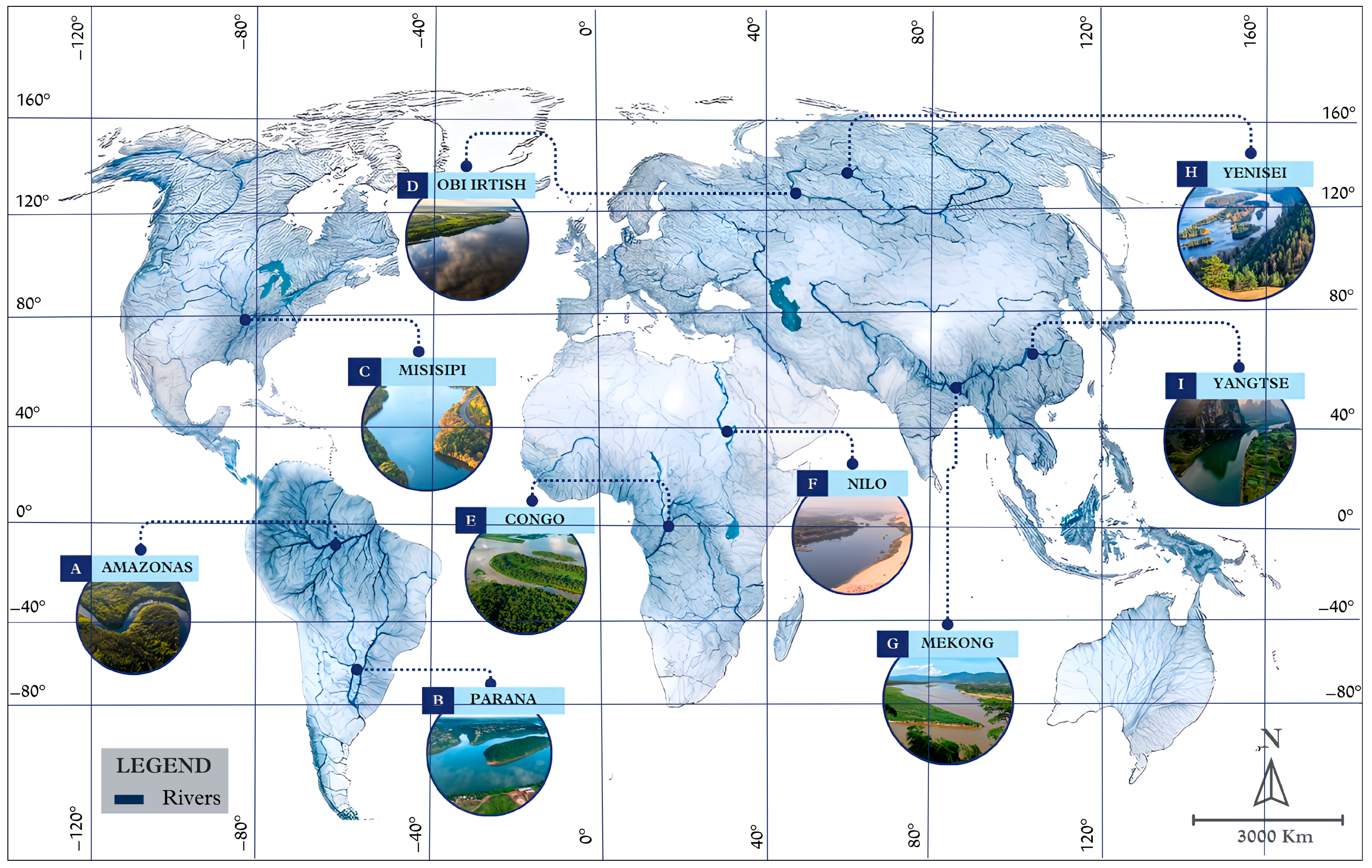
  8. Los Ríos Más Importantes del Mundo. Fundación Aquae. 2015. Available online: https://www.fundacionaquae.org/wiki/los-rios-mas-importantes-del-mundo/amp/ (accessed on 2 May 2024).
  9. Rost, S. Water management in Mesopotamia from the sixth till the first millennium B.C. Wiley Interdiscip. Rev. Water 2017, 5, e1230. [Google Scholar] [CrossRef]
  10. Ancajima Ojeda, R. Tecnologías Ancestrales-Sistemas Hidráulicos Pre-Incas e Incas. In En Conferencia Magistral en el Día Nacional de la Diversidad Biológica; Ministry of the Environment: Magdalena del Mar, Peru, 2013; Available online: https://www.minam.gob.pe/diadiversidad/wp-content/uploads/sites/63/2015/01/resumen1.pdf (accessed on 5 May 2024).
  11. Estallo, I.G.I.; Gómez, C.P. La importancia del agua en las civilizaciones antiguas: Los íberos. Tecnol. Agua 2008, 28, 80–88. [Google Scholar]
  12. Rost, S. (Ed.) Irrigation in Early States: New Directions; The Oriental Institute of the University of Chicago; Oriental Institute Seminars of Chicago: Chicago, IL, USA, 2011; Available online: https://isac.uchicago.edu/research/publications/ois/ois-13-irrigation-early-states-new-directions (accessed on 7 May 2024).
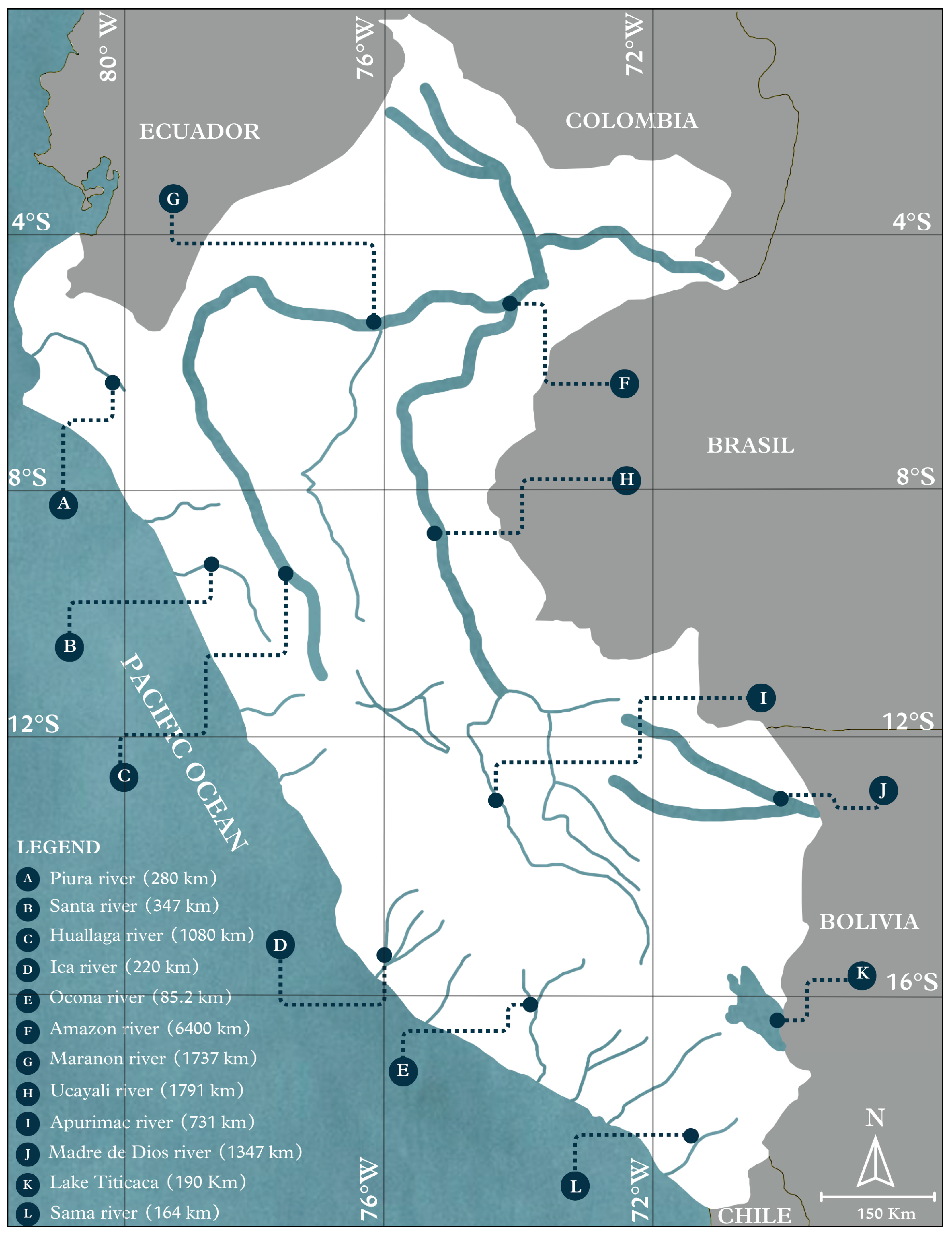
  13. Principales Ríos de América. Fundación Aquae. 2016. Available online: https://www.fundacionaquae.org/wiki/rios-del-continente-americano/amp/ (accessed on 12 May 2024).
  14. Gob.pe. Available online: https://www.midagri.gob.pe/portal/42-sector-agrario/recurso-agua/325-rios (accessed on 10 May 2024).
  15. Estación Biológica Ucayali. Network of Biological Stations. Available online: https://www.biostations.net/estaciones/ucayali/ (accessed on 13 May 2024).
  16. Ucayali. Aguas Amazónicas Alianza, 2022. Available online: https://aguasamazonicas.org/cuencas/cuencas-principales/ucayali (accessed on 15 May 2024).
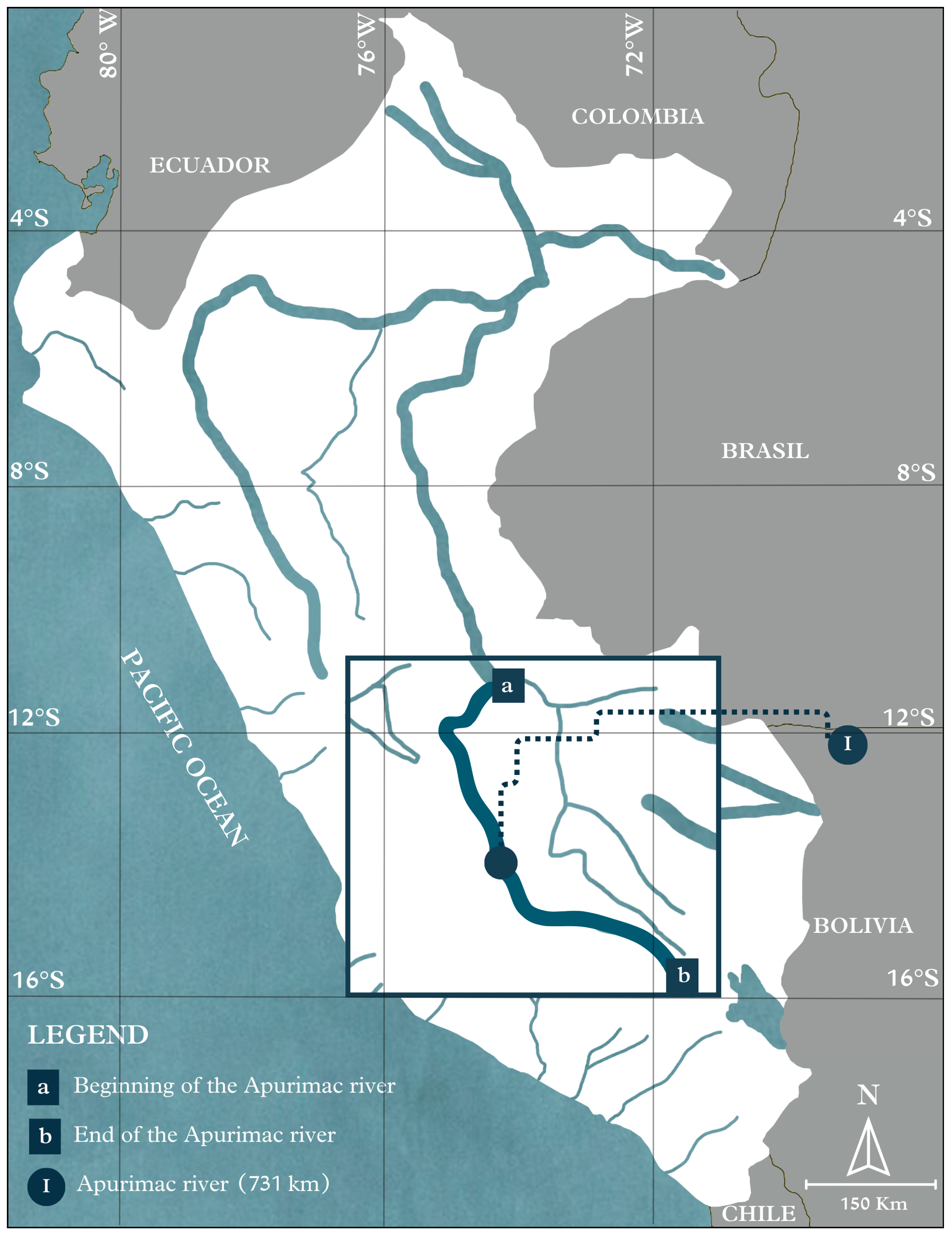
  17. Castro, W. Mesozonificación Ecológica y Económica para el Desarrollo Sostenible del Valle del Río Apurímac-VRA; Geología, Informe temático; VRA: Iquitos, Perú, 2010; Available online: http://terra.iiap.gob.pe/assets/files/meso/10_zee_vra/02_Geologia.pdf (accessed on 15 May 2024).
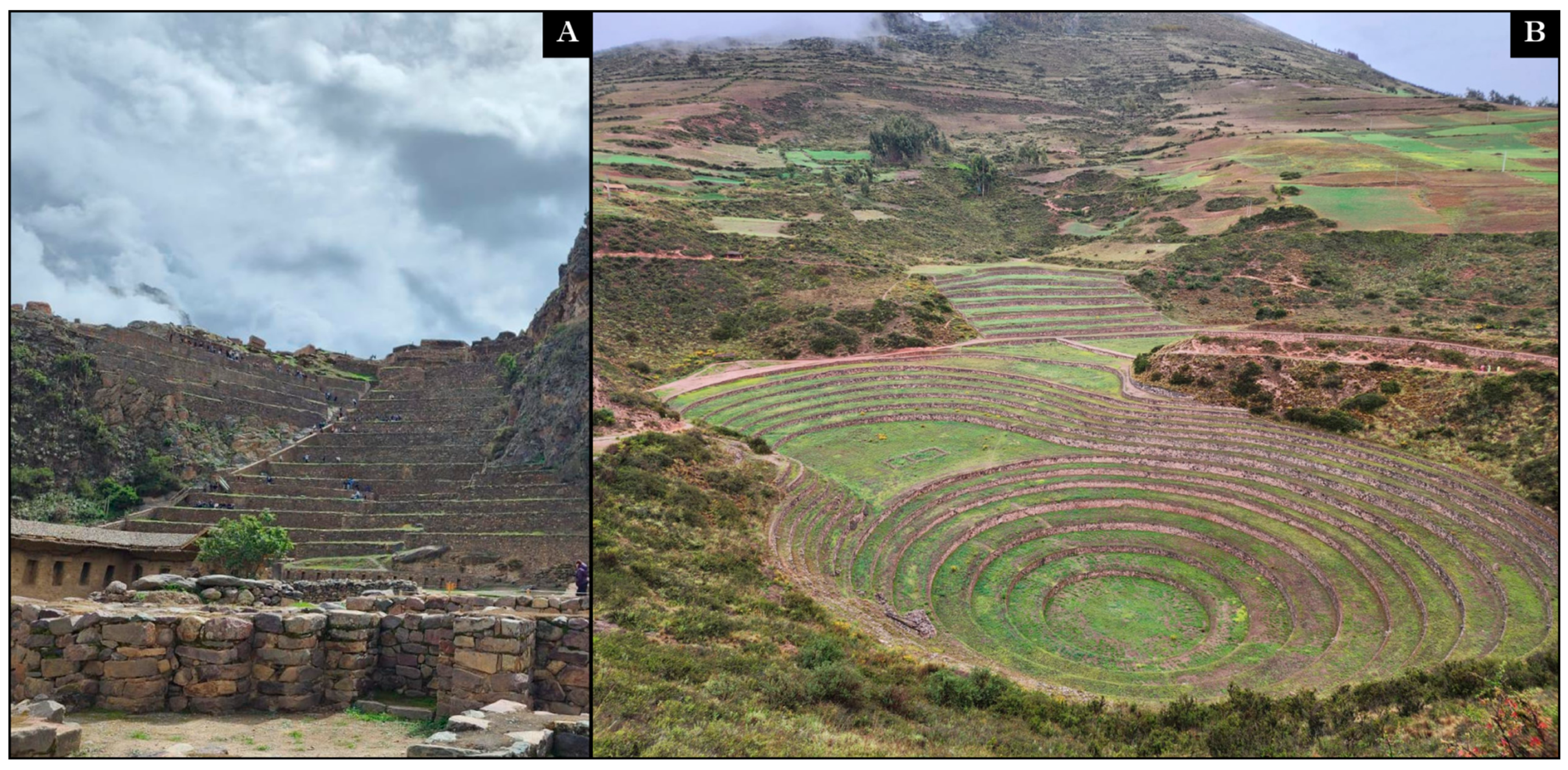
  18. Condori Llamacchima, J. Restauración y Puesta en valor del Monumento Prehispánico del Parque Arqueológico de Tipón Sector Pukara Alto Componente de Infraestructura; Ministry of Culture Cusco: Cusco, Perú, 2016; Available online: http://181.176.220.76:8080/bitstream/ddccusco/803/1/Pukara%20Alto%202015.pdf (accessed on 15 May 2024).
  19. Protzen, J.-P. Arquitectura y Construcción Incas en Ollantaytambo; Pontificia Universidad Catolica del Peru: Lima, Perú, 2005; Available online: https://www.fondoeditorial.pucp.edu.pe/arte-y-arquitectura/161-arquitectura-yconstruccion-incas-en-ollantaytambo.html (accessed on 30 May 2024).
  20. Wright, K.R.; Wright, R.M.; Valencia Zegarra, A.; McEwan, G.F. Moray: Inca Engineering Mystery; American Society of Civil Engineers: Reston, VA, USA, 2011. [Google Scholar]
  21. Ruth, P.F. Impacto Ambiental y Social Generado por el Desarrollo del Turismo en la Comunidad de Choquepata, Estudio de Caso: Parque Arqueológico de Tipón en el Distrito de la Región Oropesa-Cusco; Repository of the University of Madre de Dios: Madre de Dios, Perú, 2012; Available online: https://repositorio.unamad.edu.pe/handle/20.500.14070/180 (accessed on 11 June 2024).
  22. Carreño-Collatupa, R.; Hostnig, R. Manifestaciones Rupestres en el Parque Arqueológico de Tipón (Cusco-Perú). Rev. Cuad. Arte Prehist. 2023, 16, 1–47. [Google Scholar] [CrossRef]
  23. Tipon. Inca Hydraulics. 2011. Available online: https://hidraulicainca.com/cusco/tipon/ (accessed on 11 June 2024).
  24. Hostnig; Rainer; Raúl, C. The petroglyphs and lithographs of Cruzmoqo–Tipón. In Magazine of el Museo de Arqueología, Antropología e Historia No. 10; National University of Trujillo: Trujillo, Perú, 2008; Available online: https://www.academia.edu/3180953/Petroglifos_y_litograbados_de_Cruz_Moqo_Tip%C3%B3n (accessed on 20 June 2024).
  25. Rosa; Giuseppe, R. El Complejo Arqueológico de Tipón, Cusco, con el sector de Pukará Alto y su Kallanka. Academia.edu. 2022. Available online: https://www.academia.edu/104503255/El_Complejo_Arqueol%C3%B3gico_de_Tip%C3%B3n_Cusco_con_el_sector_de_Pukar%C3%A1_Alto_y_su_Kallanka_Raffaello_Giuesppe_Rosa (accessed on 28 June 2024).
  26. Sharps, C.I.; Linares, C.G. El arte de las obras hidraúlicas prehispánicas. Paradigmas 2010, 2, 93–108. [Google Scholar] [CrossRef]
  27. Valdivia, A.; Manuel, V. Eficiencia Hídrica del Sistema de Riego Tipón Inka, Considerando la Concepción del Sistema y sus Obras de Infraestructura Hidráulica Cusco-2020; Repository of the Andean University of Cusco: Cusco, Perú, 2022; Available online: https://repositorio.uandina.edu.pe/item/2cbf40d9-a170-42bc-aa6a-aaf7a9d2ea20 (accessed on 18 July 2024).
  28. Deslizamiento Bloquea Vía de Acceso al Parque Arqueológico de Tipon–Cusco Decentralized Directorate of Culture. Gob.pe. Available online: https://www.culturacusco.gob.pe/noticia/imagen/derrumbe-bloquea-pista-de-acceso-al-parque-arqueologico-de-tipon/ (accessed on 18 July 2024).
  29. En Tipon Dirección de Cultura Restaura Más de 2 Kilómetros De Camino Inka–Deconcentrated Directorate of Culture of Cusco. Gob.pe. Available online: https://www.culturacusco.gob.pe/noticia/patrimonio-cultural/en-tipon-direction-de-cultura-restaura-mas-de-2-kilometros-de-camino-inka/ (accessed on 7 August 2024).
  30. Prada, J.C. Gestión del Agua en la Cuenca del Rio Hua-Tanay y la Concertacion Para el Tratamien-to de Problemas Ambientales; Instituto de Manejo de Agua y Medio Ambiente–IMA: Cusco, Peru, 2022; Available online: https://www.ima.org.pe/publicaciones/experiencias/PUB_huatanay.pdf (accessed on 7 August 2024).
  31. Cuya, N.; Estrada, P.; Esenarro, D.; Vega, V.; Vilchez Cairo, J.; Mancilla-Bravo, D.C. Comfort for users of the educational center applying sustainable design strategies, Carabayllo-Peru-2023. Buildings 2024, 14, 2143. [Google Scholar] [CrossRef]
  32. Esenarro, D.; Vilchez, J.; Adrianzen, M.; Raymundo, V.; Gómez, A.; Cobeñas, P. Management Techniques of Ancestral Hydraulic Systems, Nasca, Peru; Marrakech, Morocco; and Tabriz, Iran in Different Civilizations with Arid Climates. Water 2023, 15, 3407. [Google Scholar] [CrossRef]
  33. Ortloff, C.R. Inka hydraulic engineering at the Tipon royal compound (Peru). Water 2022, 14, 102. [Google Scholar] [CrossRef]
  34. Senamhi–Stations. Gob.pe. Available online: https://www.senamhi.gob.pe/?&p=estaciones (accessed on 14 August 2024).
  35. Tafur Anzualdo, V.I.; Aguirre Chavez, F.; Vega-Guevara, M.; Esenarro, D.; Vilchez Cairo, J. Causes and Effects of Climate Change 2001 to 2021, Peru. Sustainability 2024, 16, 2863. [Google Scholar] [CrossRef]
  36. Datos Climáticos y Meteorológicos Históricos Simulados Para Cuzc. Meteoblue. Available online: https://www.meteoblue.com/es/tiempo/historyclimate/climatemodelled/cuzco_per%c3%ba_3941584 (accessed on 20 August 2024).
  37. Flora y Fauna en Tipón. CuscoMania. Admin. 2010. Available online: https://www.cuscomania.com/contributors/flora-y-fauna-en-tipon.html (accessed on 20 August 2024).
  38. Caucha, C.; Luz, M. Conocimiento Sobre el Calentamiento Global de la Tierra, Según los Alumnos de 5° de Educación Secundaria en el Cusco, 2012. Edu.Pe. Available online: https://repositorio.ucsm.edu.pe/server/api/core/bitstreams/d061d739-40a5-4ec7-847d-c0fa77a8ecb7/content (accessed on 20 August 2024).
  39. De Canchis ERV-UR las P.Río Vilcanota-Urubamba 2007. Gob.pe. Available online: http://www.digesa.minsa.gob.pe/DEPA/rios/2007/vilcanota_07.pdf (accessed on 20 August 2024).
  40. Google Earth. Available online: https://earth.google.com/web/search/TIPON/@-13.5653737,-71.78135861,3572.21005146a,4424.9644067d,35y,0h,0t,0r/data=CnAaR-hJACiUweDkxNmU3ZDNlNDMwZGI4MmQ6MHhmN2JkY2JhZjUxY2NiYzE4Gb4o5sUuIivAIVbjtscc8lHAKgVUSVBPThgCIAEiJgokCeuUbGtDFCvAEZ8GRBe0LivAGb3S3GVX7lHAIV4xitSt9VHAOgMKATA (accessed on 11 June 2024).
  41. Ortiz García, E. Los Incas y el Sol: Métodos de Observación Solar y Calendario Incaicos; Revista Española de Antropología Americana: Madrid, Spain, 2012; Available online: https://pdfs.semanticscholar.org/ae64/41ad38737f20a705e805d4e84f52fa4812bd.pdf (accessed on 9 September 2024).
  42. Greshk, M. ¿Qué es el Solsticio de Invierno? Esto es Todo lo Que Necesitas Saber; National Geographic: Washington, DC, USA, 2020; Available online: https://www.nationalgeographic.es/ciencia/2020/12/que-es-el-solsticio-de-invierno-esto-es-todo-lo-que-necesitas-saber (accessed on 9 September 2024).
  43. Saloma, T.D. Repository of the Andean University of Cusco. Available online: https://es.slideshare.net/slideshow/tesis-diego-saloma-u-andina-cusco/57330113 (accessed on 9 September 2024).
  44. Wikipedia Contributors. Tipon. Wikipedia, The Free Encyclopedia. Available online: https://es.wikipedia.org/w/index.php?title=Tip%C3%B3n&oldid=159823566 (accessed on 21 September 2024).
  45. Wright, K.R.; Mcewan, G.F.; Wright, R. Tipón: Masterpiece of Hydraulic Engineering from the Inca Empire; EDUNI: Lima, Perú, 2008. [Google Scholar]
  46. Francis, C.D. Arquitectura. Forma, Espacio y Orden; Editorial GG: Barcelona, Spain, 2016; Available online: https://elateoriaarq.wordpress.com/wp-content/uploads/2016/12/arquitectura-forma-espacio-y-orden-francis-d-k-ching_redacted.pdf (accessed on 21 September 2024).
  47. Zeballos, C.; Completo, V.P. Tipon, el Agua y Los Incas. Available online: https://moleskinearquitectonico.blogspot.com/2009/07/tipon-el-agua-y-los-incas.html (accessed on 21 September 2024).
  48. Barreto, M.I.B. Condiciones de Salud de los Antiguos Pobladores del Complejo Maranga: Una Visión General Desde el Intermedio Temprano hasta la Colonia. In Arqueología; Catorce años de Investigaciones en Maranga; Municipalidad Metropolitana de Lima: Lima, Peru, 2014; pp. 211–224. Available online: https://www.academia.edu/78613294/Condiciones_de_salud_Antiguos_Pobladores_de_Maranga_una_visi%C3%B3n_general_desde_el_intermedio_temprano_hasta_la_colonia (accessed on 9 October 2024).
  49. Abarca Ancori, A. Estudio de los Conocimientos Geotécnicos en el Periodo Inca, Casos, Llagtas Incas de Machupis. shu Ollantaytambo, Pisaq, Ragchi, Tipón y Sagsaxwaman, en el Departamento de Cusco, 2017; Institutional Repository-UNSAAC: Lima, Peru, 2018; Available online: https://repositorio.unsaac.edu.pe/handle/20.500.12918/3800 (accessed on 9 October 2024).
  50. Amico, J.C. El Imperio Inka: La Integración Macrorregional Andina y el Apogeo de la Planificación; PUCP Institutional Repository: Lima, Peru, 2006; Available online: https://repositorio.pucp.edu.pe/index/handle/123456789/28680 (accessed on 9 October 2024).
  51. FAO. Manejo de Suelos Arenosos. Fao.org. Available online: https://www.fao.org/soils-portal/soil-management/manejo-de-suelos-problematicos/suelos-arenosos/es/ (accessed on 2 November 2024).
  52. Zapata, R. Tipos de Suelos: Caracterización de Suelos Arcillosos y Limosos; Universidad Nacional de Rosario: Maipú, Chile, 2018; Volume 27, Available online: https://www.fceia.unr.edu.ar/geologiaygeotecnia/TIPOS%20DE%20SUELO.pdf (accessed on 2 November 2024).
  53. Rucks, L.; García, F.; Kaplán, A.; de León, J.P.; Hill, M. Propiedades Físicas del Suelo; Facultad de Agronomía, Universidad de la República: Montevideo, Uruguay, 2004; Available online: https://bibliofagro.pbworks.com/f/propie-dades-fisicas-del-suelo.pdf (accessed on 2 November 2024).
  54. Programa de Geología y Geotecnia. Edu.ar. Available online: https://www.fceia.unr.edu.ar/geologiaygeotecnia/Geologia%20y%20Geotecnia%202014.pdf (accessed on 2 November 2024).
  55. Esenarro, D.; Rodriguez, C.; Arteaga, J.; Garcia, G.; Flores, F. Aprovechamiento sostenible de los recursos naturales para mejorar la calidad de vida en el centro poblado alto palcazu, iscozazin-peru. Rev. Int. Cienc. Ambient. Desarro. 2021, 12, 146–150. [Google Scholar] [CrossRef]
Figure 1. World map of the most important rivers.
Heritage 07 00307 g001
Figure 2. Map of rivers in Peru.
Heritage 07 00307 g002
Figure 3. Approach of the start and end of the Apurimac River.
Heritage 07 00307 g003
Figure 4. (A) Ollantaytambo Archaeological Center; and (B) Moray Archaeological Center.
Heritage 07 00307 g004
Figure 5. (A) Thirteen terraces; (B) Main spring; (C) Water channels; and (D) Stairs.
Heritage 07 00307 g005
Figure 6. (A) Landslide blocks access road to the Tipon Archaeological Park reprinted with permission from Ref. [28]. 2023, Carlos Poma; and (B) In Tipon, the Department of Culture restores over 2 km of Inca road, reprinted with permission from Ref. [29]. 2018, Carlos Poma.
Heritage 07 00307 g006
Figure 7. Methodology.
Heritage 07 00307 g007
Figure 8. Steps for developing the analysis.
Heritage 07 00307 g008
Figure 9. (A) Map of South America, Cusco Department; (B) Map of Cusco, Quispicanchi Province; and (C) Map of Oropesa District.
Heritage 07 00307 g009
Figure 10. (A) Annual average of the climate analysis for Tipon; and (B) Statistical data.
Heritage 07 00307 g010
Figure 11. Flora of the Tipon Hydraulic Center.
Heritage 07 00307 g011
Figure 12. Map of rivers in the Tipon Hydraulic Center.
Heritage 07 00307 g012
Figure 13. (A) Map of the province of Quispicanchi; (B) Map of the district of Oropesa; and (C) Map of the Tipon Hydraulic System.
Heritage 07 00307 g013
Figure 14. (A) Solar rotation analysis at 9:00 a.m.; (B) Solar rotation analysis at 11:00 a.m.; and (C) Solar rotation analysis at 4:00 p.m.
Heritage 07 00307 g014
Figure 15. (A) Topographic map; (B) 3D topography; and (C) Topographic section.
Heritage 07 00307 g015
Figure 16. (A) Flows present at the archaeological center of Tipon; (B) Longitudinal section A–A’; and (C) Cross-section B–B’.
Heritage 07 00307 g016
Figure 17. Water points: (A) Principal fountain, (B) Second principal fountain, and (C) Water flow adjacent to the vertical circulation present on the fourth terrace.
Heritage 07 00307 g017
Figure 18. (A) Main fountain; and (B) Second main fountain.
Heritage 07 00307 g018
Figure 19. (A) Location plan of Tipon; and (B) Diagram of the water system on a slope.
Heritage 07 00307 g019
Figure 20. Hierarchy of water channels. (A) Main channel, (B) Secondary channel, (C) Distribution channel, (D) Irrigation channel, and (E) Drainage channel. Views: (1) View from the second terrace, and (2) View from the fifth terrace.
Heritage 07 00307 g020
Figure 21. Construction materials: (A) Andesita stone, and (B) Labradorita crysta.
Heritage 07 00307 g021
Figure 22. Stratum present in the Archaeological Center of Tipon. Channels.
Heritage 07 00307 g022
Table 1. Specific characteristics of the Strata at the Archaeological Center of Tipon.
StratumSiltSandClayLoam
TextureMedium [53]Medium [51]Fine soil [52,54]Medium [52]
Water retentionMedium height [53]Medium height [51]High [52,54]Medium [52]
Water infiltrationHigh [53]Low [51]Low [52,54]Medium [52]
ErosionMedium-low [53]Medium-low [51]High [52,54]Medium [52]
Disclaimer/Publisher’s Note: The statements, opinions and data contained in all publications are solely those of the individual author(s) and contributor(s) and not of MDPI and/or the editor(s). MDPI and/or the editor(s) disclaim responsibility for any injury to people or property resulting from any ideas, methods, instructions or products referred to in the content.

