Article

The WAS Project—Waterscape Archaeology in Sicily at Isola delle Femmine (PA, Italy): Submerged and Emerged Heritage

Cultural Heritage Department, University of Padova, 35129 Padova, Italy
Heritage 2022, 5(3), 2773-2803; https://doi.org/10.3390/heritage5030144
Submission received: 25 August 2022 / Revised: 6 September 2022 / Accepted: 8 September 2022 / Published: 19 September 2022
(This article belongs to the Special Issue 3D Modeling for Cultural Heritage and Applications)

Abstract

:
The WAS—Waterscape Archaeology in Sicily—project is dedicated to underwater cultural heritage mapping, knowledge and awareness of the cultural heritage, dissemination, and analysis of the submerged environment concerning the coast. The prototype investigation site presented here is Isola delle Femmine (PA, Italy). This paper highlights the archaeological discovery with a description of the main finds, across a multidisciplinary approach, carried out with low-cost technology, increasing sustainable diving, and underlining the relationship between submerged and open-air historical evidence. Our studies address the realization of new underwater archaeological itineraries connected to local history. This text provides a historical-archaeological introduction to understanding the context of the site and, with some geological notes, illustrates the phases of the research with a presentation of the main artifacts, with a focus on the methodology and the techniques of the surveys and the usefulness of underwater photogrammetry and 3D modeling with a particular focus on the tourism application in the diving centers. Our work has allowed for the creation of two new underwater archaeological itineraries of Sicily. The innovative aspects of our project are linked to a new holistic approach in the context of the scientific synergy between multiple disciplines.

1. Introduction

1.1. The WAS Project
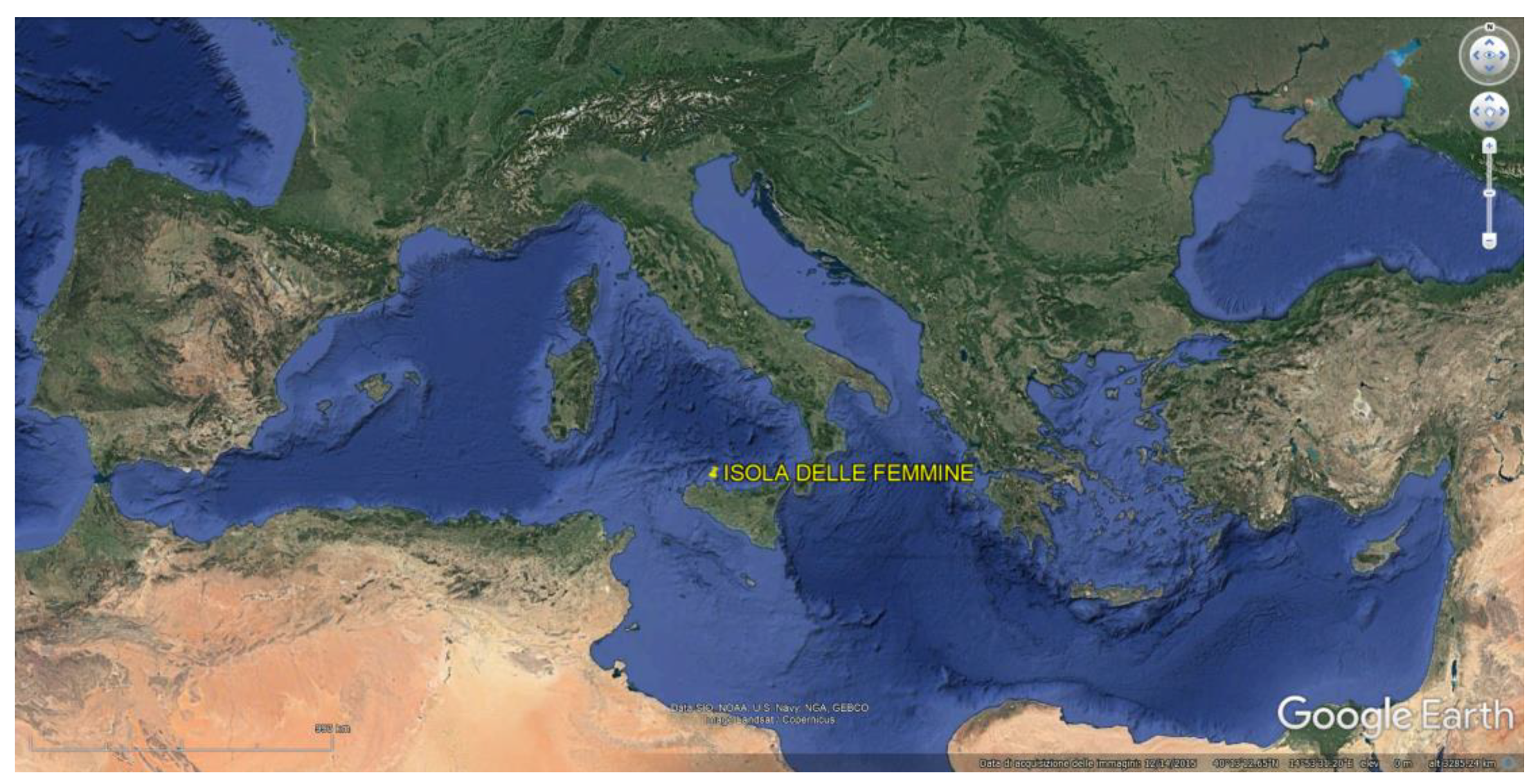
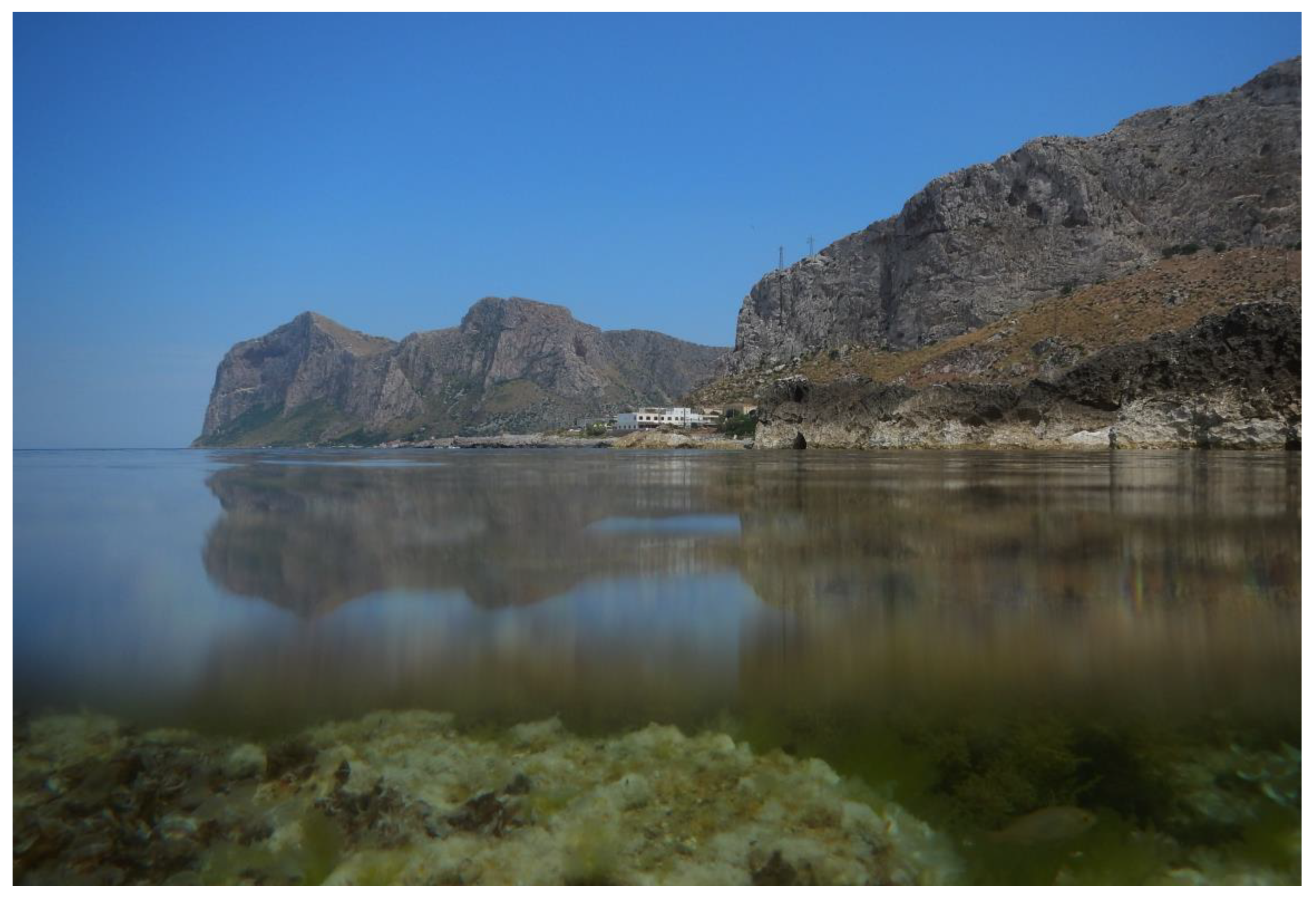
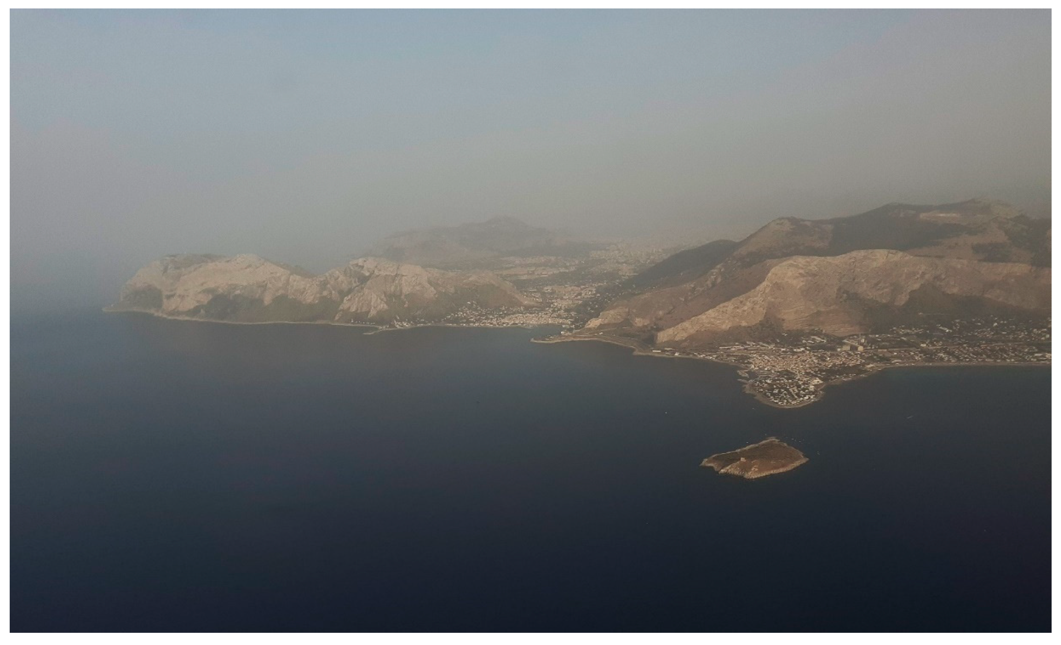
WAS (Waterscape Archaeology in Sicily) is a didactic and research project of the Federation ITA F07 CDCI, CMAS Diving Center Italia-Confédération Mondiale des Activités Subaquatiques, coordinated by who is writing. It takes place with the patronage, scientific direction, and collaboration of the Superintendence of the Sea, Sicilian Region, Department of Cultural Heritage and Sicilian Identity, Department of Cultural Heritage and Sicilian Identity, of the Underwater Archaeology Laboratory, Department of Cultural Heritage-Archaeology, History of Art, Cinema and Music of the University of Padua, with the patronage of the Municipality of Isola delle Femmine and Sealine-Center for coastal studies of the Department of Architecture of the University of Ferrara, with the collaboration of the Aeronautical Operations Department of the Guardia di Finanza of Palermo (2016). The project works with the technical collaboration of ASD J. Cousteau, Progetto Mare (2016–2018), and Diving Saracen Isola delle Femmine (2021).
The project is dedicated to research, teaching, studying, conservation, and protecting coastal and underwater cultural heritage through an eco-sustainable approach to the marine world, using the best practices for scientific diving in the perspective of Waterscape Archaeology, as a multidisciplinary science dedicated to the study of the interaction between man and aquatic environment, underlying the relationship between emerged and submerged landscape, and connecting land and water [1].
The prototype site of the project is Isola delle Femmine (Palermo, Italy—Figure 1), a place where a significant coastline and a rich maritime heritage provide great opportunities for archaeological research and tourism planning (Figure 2).
Within the project, four underwater archaeology courses were carried out, during which scientific surveys were completed with pre-cataloging of the main findings. The artifacts have been photographed, measured, and georeferenced. An additional 3D survey has been completed for some remarkable archaeological artifacts, including the surrounding geomorphological context, a key point of the submerged area.
The project, through the organization of three European events, Satellite Event partner of the EU Green Week, EU Energy Week, and EU Maritime Days, is dedicated to the synergy between scientific disciplines studying the submerged environment and has developed the dissemination with satellite events, organized with the Environmental European Commission, the Energy European Commission, and the European Commission of Maritime Affairs (S4—Scuba Scientific Synergy Energy Saving, 2016; UAW—Underwater Archaeology Work, a green/blue job, 2017; WiC—Water is Culture, 2018; EMD In My Country Events G4G—Guide for guides surveys and realization of underwater archaeological itineraries, 2020; S.UND.A.I.—Sustainable Underwater Archaeological Itineraries Project, 2021; EMD Day Progetto A-mare 2021; all the events are available on the Twitter page https://twitter.com/CDCI_Scientific (accessed on 9 September 2022).
The first purpose of the research was the mapping of the seabed of Isola delle Femmine, as a contribution to the Archaeological Map of the Submerged Heritage of Sicily.
The second purpose was the planning and the construction of some new underwater archaeological itineraries in accordance with the European Sustainable Development Goals, 14 Life below water and 15 Life on land in the governance of the global ambition “zero pollution”, an underwater environment free of toxic substances, a circular economy aimed at the conservation of the sea, and sustainable cultural tourism.
To complete the systematic archaeological investigations performed with the students, the team also worked on photogrammetry, video-mapping, 3D modeling, and surveys, under the guidance of the specialists of the Superintendence of Sea, the Archaeologist Fabrizio Sgroi, and the Honorary Inspector for the maritime cultural heritage of the province of Palermo Engineer Gaetano Lino.
The project’s innovative aspects are linked not only to the creation of new eco-sustainable underwater archaeological itineraries but also to the use of geomatics with an educational and informative aspect related to the diving experience, especially pre-diving briefings and didactics.
This is a multidisciplinary study, connecting historical and archaeological data, toponymy, ancient sources, and sphragistics, attesting to a new approach with a systematic methodology.
In the ambit of cultural heritage, several works have been conducted on photogrammetry and 3D models, but most of them are dedicated to wrecks with a cargo of amphora, columns, and marbles [2]; up till now, no study has dealt with the relationships between built cultural heritage and underwater finds in the vicinity of the structures in the ambit of waterscape archaeology (some comparative methodologies are presented by Menna and Nocerino [3,4], but in different archaeological and environmental contexts).
In this work, the first photogrammetric survey of a very rare, preserved instrument for coral fishing is presented (unpublished instrument), together with the first 3D model of the ingenium, ascribable to the Late Antiquity-Middle Ages. The data collected constitute a new point of reference for future studies on this type of ancient tool. Currently, we are engaged in a specific study on the ingenia by addressing the aspects relating to ancient literary sources and documentation, comparing the artifacts found in Sicily and Sardinia that are unpublished or only partially known tools. The details of our research will, therefore, be useful for all the archaeologists dealing with maritime tangible and intangible cultural heritage (see Section 4 and Section 5).

1.2. The Location

The Municipality of Isola delle Femmine is situated in the geographical context of northwestern Sicily, in the province of Palermo; it occupies a part of the coastal land and a small island located in the Capo Gallo–Isola delle Femmine Marine Protected Area (http://www.ampcapogallo-isola.gov.it) (accessed on 9 September 2022) with natural reserve http://www.lipu.it/riserva-naturale-isola-delle-femmine-pa (accessed on 9 September 2022) (Figure 3).
The geomorphological context of the Marine Protected Area is characterized by the outcrop of the carbonate rocky substratum, structured in the form of cliffs, steps, abrasion platforms, and caves with vermetid trottoire, the prairie of Posidonia, pre-coralligenous, coralligenous, and ancient coastlines—palaeoshores [5]. The study of the geological and biological characterization was the base for the correct planning of the dives that reached a maximum depth of −30 m (with the students), in correspondence with the first beach rocks, and −54 m together with professional underwater archaeologists and marine biologists to complete autoptic surveys on some deep sectors.
Regarding the marine biology studies, the morphological and bathymetric surveys, and biocoenosis map, the most important studies have been published by Antonioli et al. [6] and Pititto et al. [7]; we refer to these studies for further details on marine biology.

1.3. Archaeological and Historical Framework

From an archaeological point of view, the site is located near the axis of the Via Valeria from Traghetto to Lilibeo, between Carini and Sferracavallo [8] (pp. 145–146) [9]; it is indicated in the cartography of al Idrīsī as al-Ĝazîrat [10]. Cluverius, in his work Sicilia Antiqua, II, 415–416.40–50, identifies Isola delle Femmine with Paconia: Paconia insula Ptole-maeo ponitour inter Osteoden e Bathys fluminis ostium, si medio fere tractu inter Panormum ac Drepanum. Quo tractu quum nulla alia sit insula, putatour esse ea, quae, haud ita procul antiquis Hyccaris, I ƆCCC circiter passus a litore distans, vulgo hodie adpellantur lIsola di Fimi, sive delle Femmine.
The toponym Isola delle Femmine, according to the writings of Carlo Castone Conte della Torre di Rezzonico Viaggio della Sicilia, published in Palermo in 1828, would derive from Insula Fimi, from the corruption of fimi, a word that in nineteenth-century Sicilian means mud. Another hypothesis can be traced back to the Arabic term fim—embouchure [11] (p. 42). The most probable origin of the toponym is connected to Insula Euphemi, from the name of the Byzantine Turmarca Euphemius, usurper of the imperial power [12], named basileus, known for falling in love with a girl and for kidnapping her [13], [14] (pp. 279–317), [15] (pp. 47–48), [16] (pp. 48–49), as reported by the late sources published in the Corpus Scriptorum Historiae Bizantinae, Theophanes Continuatus (Chronographia 27), and Georgius Coedrenus (Historiarum Compendio 512.10).
There are archaeological testimonies in the ambit of sphragistics and numismatics relating to the presence of the Turmarca in Sicily in the 9th century AD: the seal ring of Euphemius (Figure 4a), preserved at the A. Salinas Regional Archaeological Museum in Palermo [17] (p. 22), known through the Amari correspondence (IV, 1566, letter of 16 May 1884 (see [18], pp. 92–93), and a seal published by V. Prigent (catalog of the Museo Salinas n. 38233), with the Virgin and the child on the obverse, and the inscription on the reverse Euphemios es theou pistos basileus romaion [14] (pp. 375–380) (Figure 4b,c).
Isola delle Femmine is already known for its historical interest due to the presence of the so-called Land Tower (Figure 5a) and Sea Tower (Figure 5b), attributable to Renaissance phases [19,20,21].
The island has been studied since the mid-1980s with research conducted by G. Purpura, who reported the presence of African amphorae and inscribed lead anchor stocks (preserved in Palermo at the Archaeological Museum) [22,23]. Then, S. Tusa published fragments of amphorae, heterogeneous in terms of chronology and size, together with a three-hole lithic anchor [24]; the research continued with the work of R. La Rocca who studied the ancient fishing systems and fishery, attested during the Proto Imperial Period and the Late Antiquity [25,26,27]. The structures on the eastern side of the island are still visible on site: some tanks made with breccia, pebbles, and cement mixture and coated on the inside with hydraulic mortar are preserved (Figure 6a–c).
Some very recent explorations (November 2021) of the Superintendency of the Sea, assisted by Arpa Sicilia, University of Malta, Diving Center Saracen, Diving Marenostrum, and Messina Coast Guard, detected a “new” Roman shipwreck, or rather a very well-preserved cargo of amphoras, dating to the 2nd century BC [28] (Figure 7 and Figure 8).

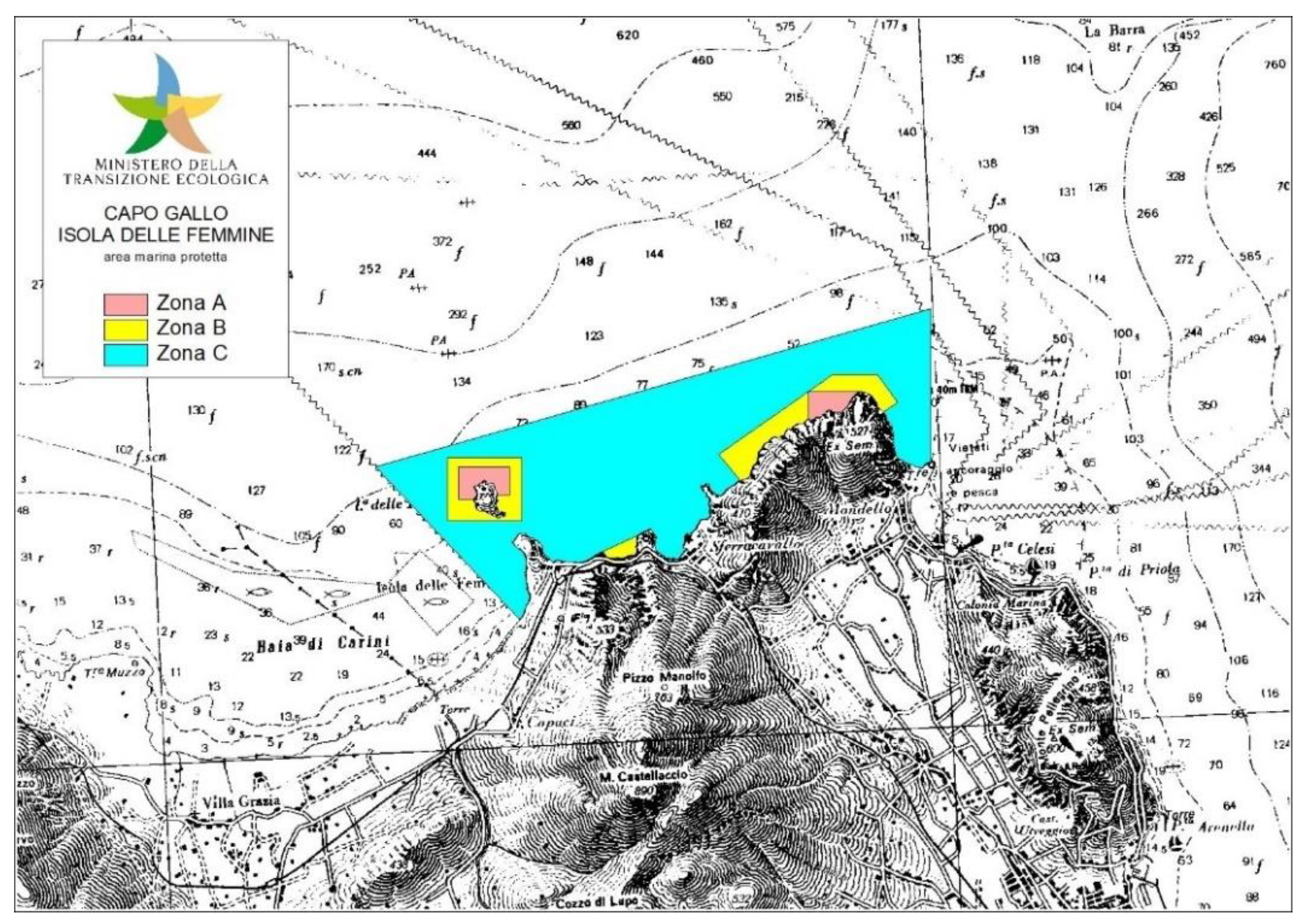
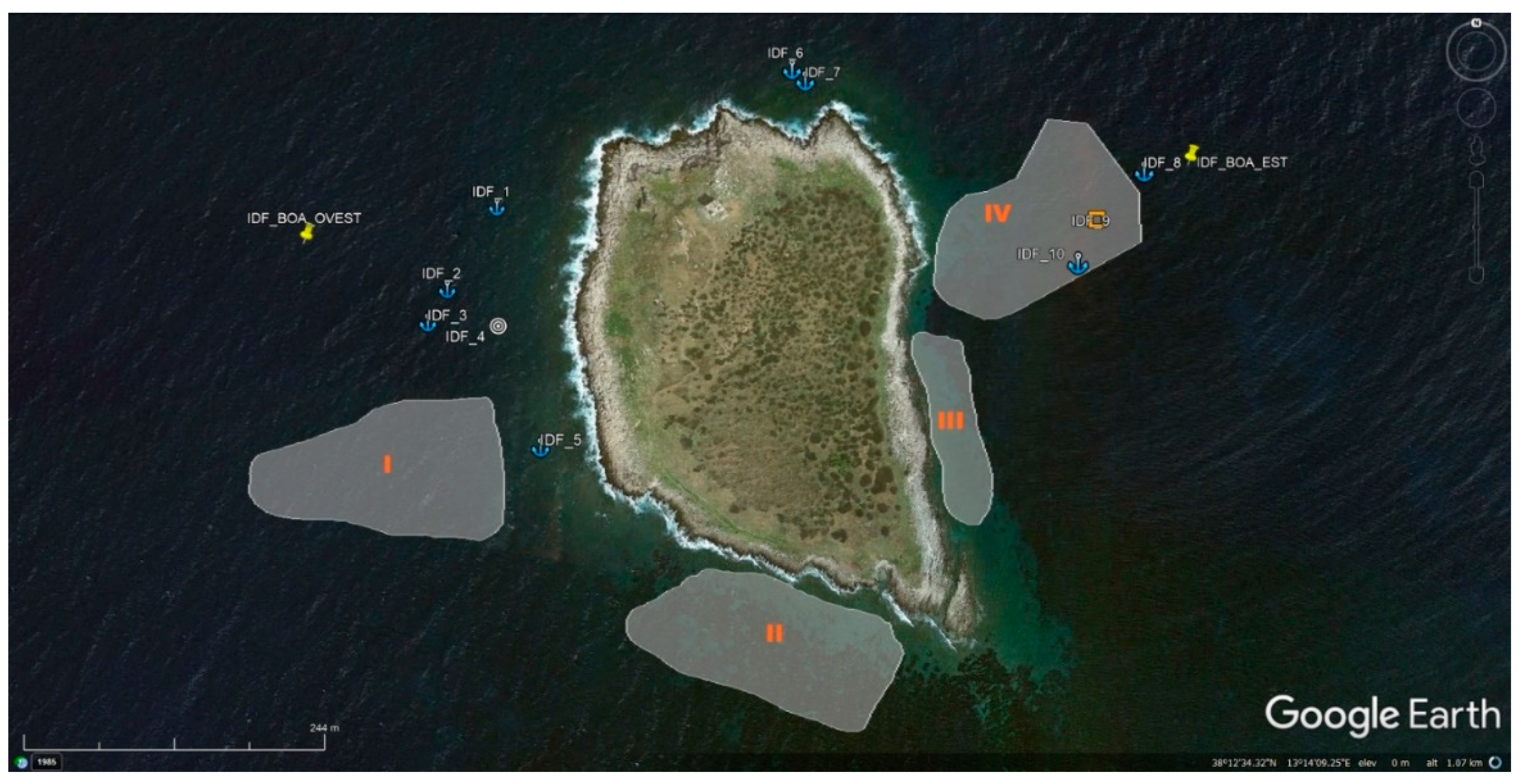
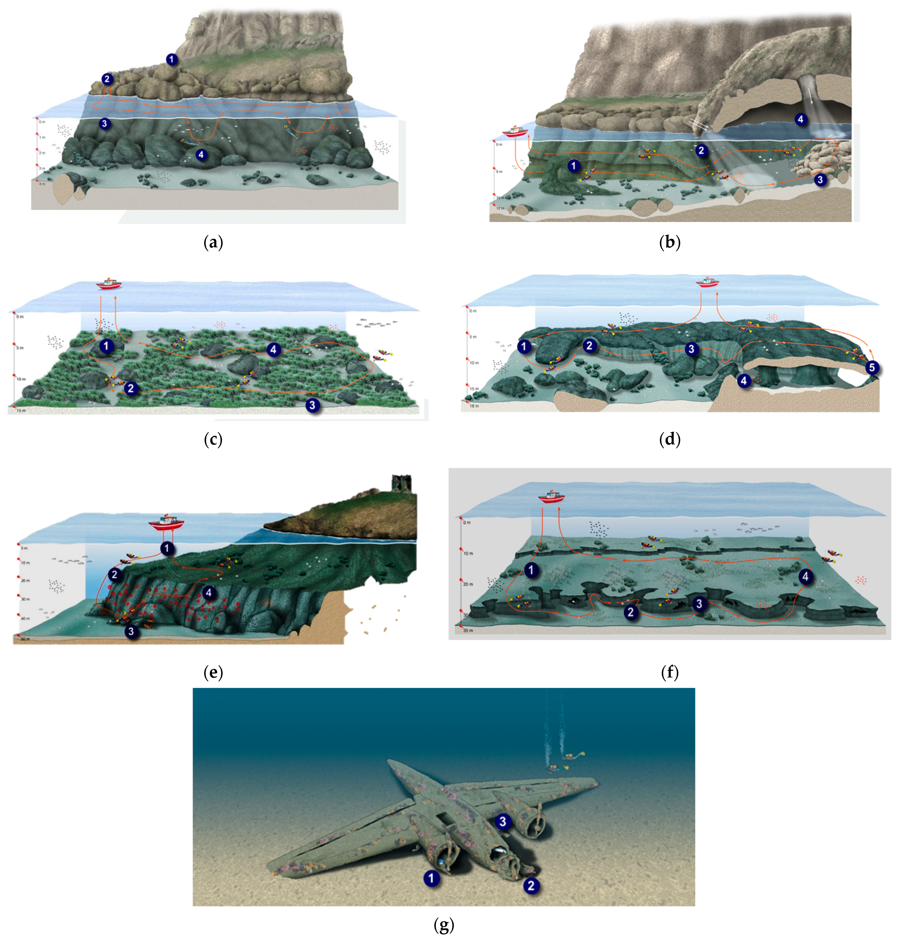
1.4. Diving in the Marine Protected Area Capo Gallo–Isola delle Femmine

The AMP Capo Gallo–Isola delle Femmine is divided into three main areas: A, B, and C concerning the different levels of protection; there are two areas of maximum protection: the northwestern and northeastern sectors of Isola delle Femmine, and in the sector of sea west of Capo Gallo, the area between Puntazza and the Capo Gallo lighthouse (Figure 9 and Figure 10).
The place already offers naturalistic and historical underwater sites: the so-called “living step” east of the lighthouse, the Grotta dell’Olio, the Posidonia prairie, the submerged tunnel, the palaeoshores, the coralligenous, and the Junkers wreck (Figure 11).
The deep seabed in front of Isola is also characterized by the presence of historical wrecks, including the Loreto, an English steamship, made in 1912 by Sunderlands S.B. Co.; the torpedo boat Chinotto; and the Junkers 52 already studied and published by the Superintendency of the Sea [32].

2. Materials and Methods

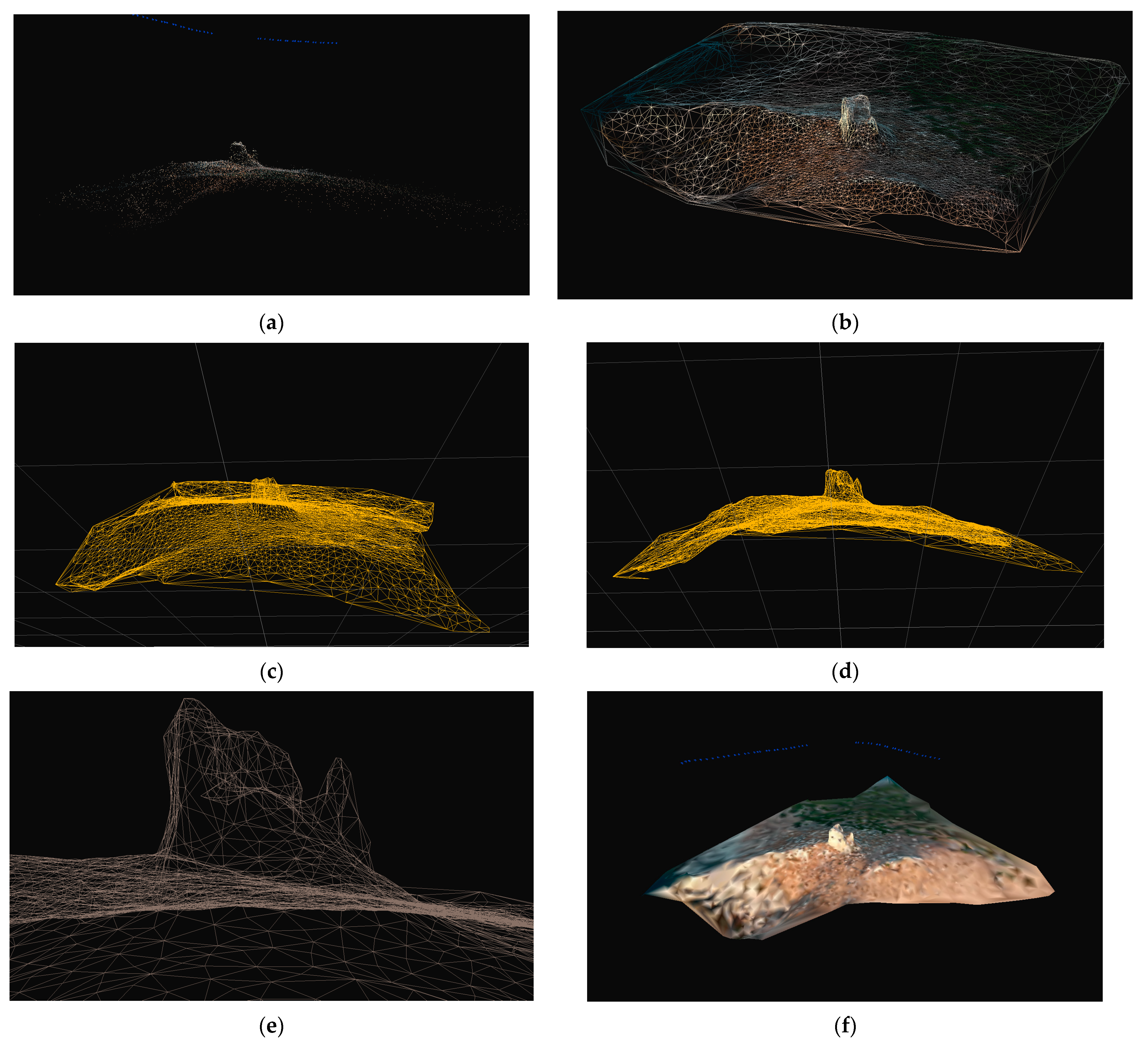
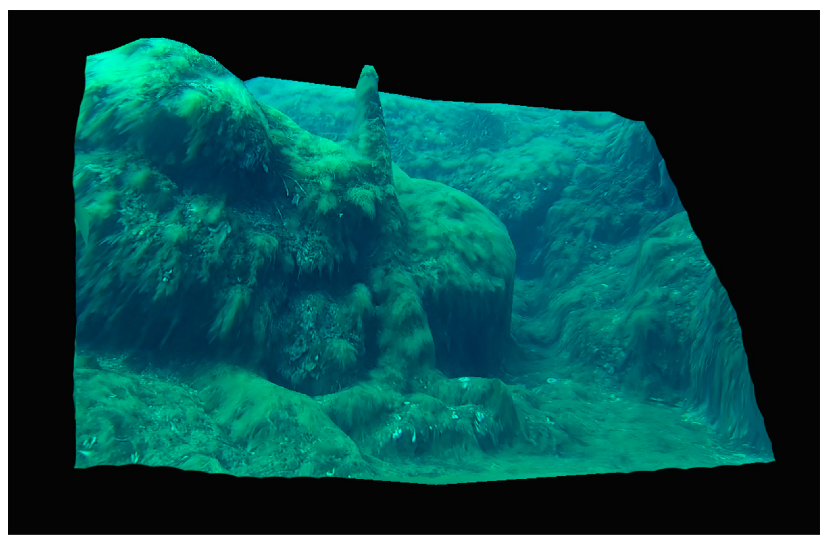
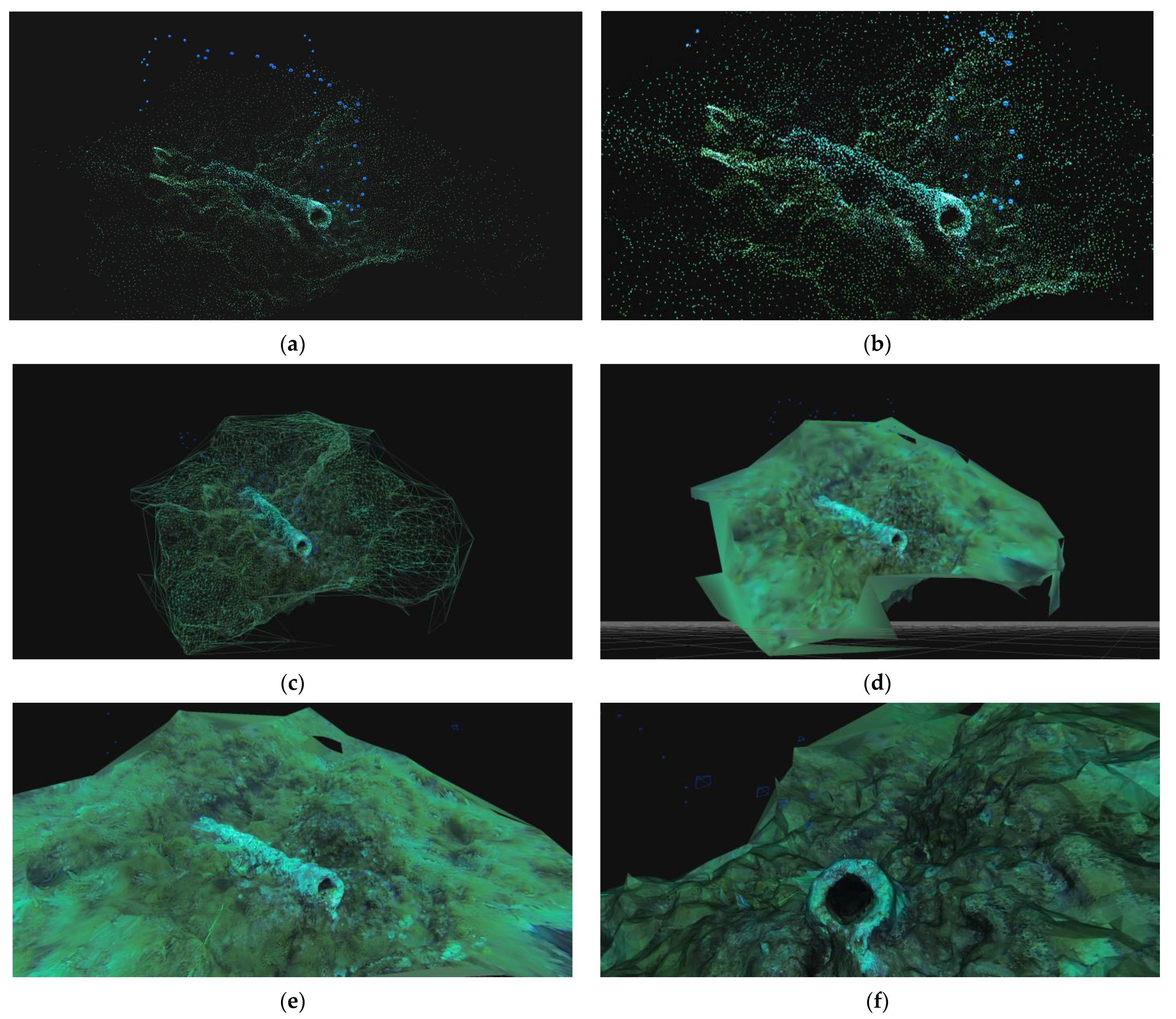
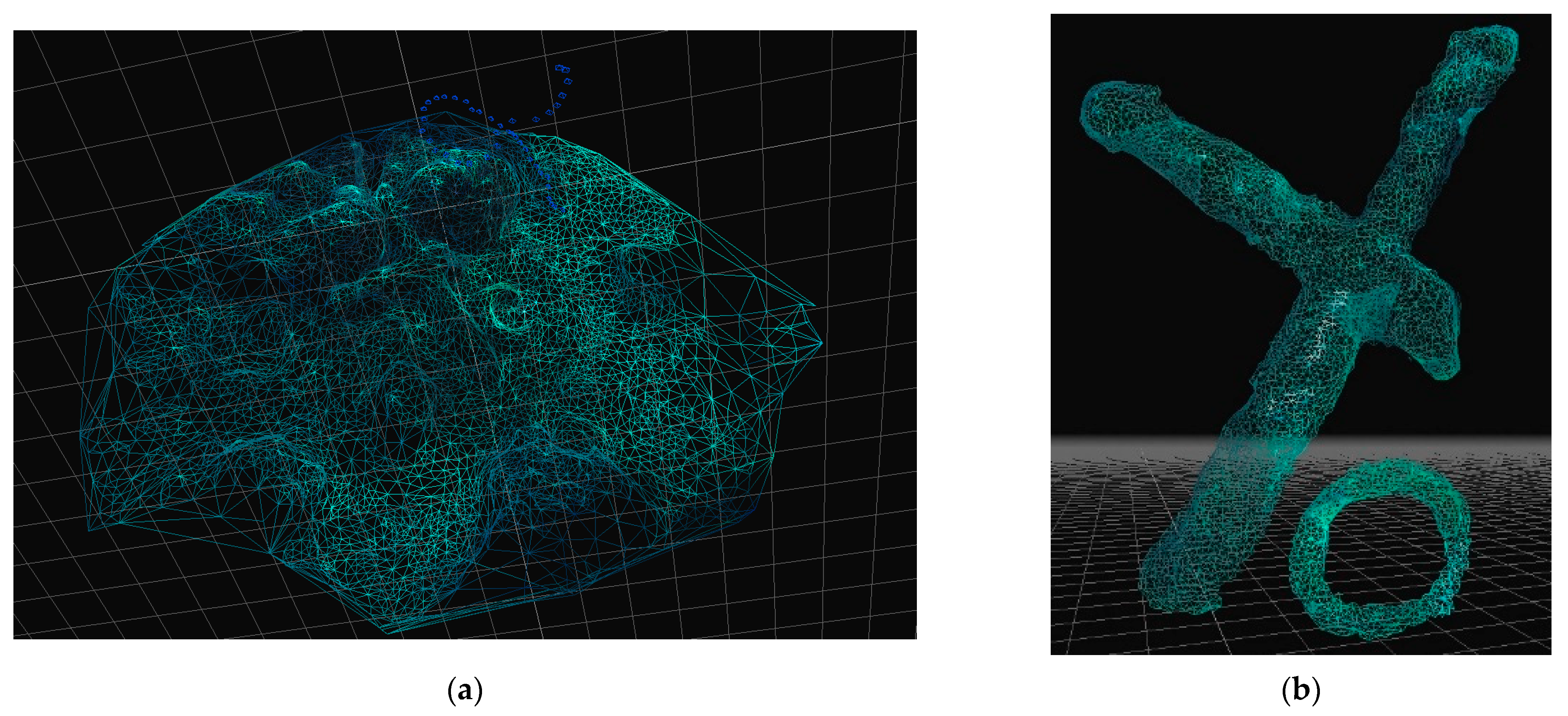
2.1. Methodology and Main Instruments

The activities of the project have been divided into four main phases.
Task 1—survey: underwater investigations, on-site documentation (georeferencing, photos with and without metric references, photographic and video documentation, photogrammetry for 3D modeling, and scale drawings, integrated with a DSM measurement of a net of control points, which has also allowed the team to compare the situation over the years), pre-cataloging of the artifacts, identification of conspicuous points for itinerary planning, creation of closed underwater polygonal lines, linear measurements, relief, and surface georeferencing, with the numbering of the findings.
Task 2—data fusion and elaboration: data processing, bibliography research and cataloging of finds, and creation of 3D models to be deposited also at the diving centers to allow a detailed and immersive scientific briefing, as well as small diving information sheets containing the name of the institution, no. of the itinerary, no. of the conspicuous point/find/stage of the itinerary, the definition of the object, material, dating, n. of inventory collocated on each artifact (Italian and English version).
Task 3—set up and presentation: positioning of the didactic labels with a chosen sequence following diving safety curve models, removal of the provisional bottom polygonal track, photos and video surveys, live presentation of the underwater itinerary from the seabed with underwater communicators, and updating of web pages and social network with follow-up of activities and preview of the itineraries (ongoing work).
Task 4—promotion and dissemination: the creation of a detailed photographic video archive about the underwater archaeological itinerary, formulation of a European visibility plan with partner events dedicated to environmental sustainability in the field of scientific research applied to the territory through conferences, workshops, courses, and guided underwater tours (work in progress).

2.2. Instruments and Geomatic

Fifty-six scientific immersions were carried out between 2016 and 2018 with technical assistance from the ASD Jacques Cousteau group, and twenty underwater scientific surveys were completed with Saracen Diving between 2020 and 2021 under the scientific supervision of the Superintendence of Sea.
The diving equipment used was made up of 15-liter cylinders filled with air equipped with double taps and instruments for diving such as computers, compass, tables for drawing, surface GPS, cameras and video cameras, portable measuring instruments, and metric references. All the equipment and safety systems were organized according to current legislation. The video cameras used for documentation were Nikon Coolpix AW110 and GoPro Hero 3 Black. The dimension of the photos is 4600 × 3400 pixels with a Nikon camera and 1100 × 750 pixels with GoPro. The accuracy of our measurements is 0.5 cm for the objects and 2 cm for the open-air structures. The software for the management of the documentation and the photogrammetry belong to the Microsoft package, meanwhile for 3D modeling with photogrammetric elaboration, we used Metashape 1.7.0 standard edition, Cloud Compare 2021, Zephyr Free 6.505.
From a methodological point of view regarding the underwater research at sea, the work included first a series of systematic surveys, developed on parallel alignments with overlapping swathes, with a width of 3 m and a length of 50 m and with north–south south–north courses, depending on the current. We found 31 points of strategic archaeological importance for the creation of the underwater cultural itineraries; based on an initial classification of the finds, we opted for a specific choice of historical interest (also connected to the local built heritage) and the possible touristic cultural attraction. Beginning with this analysis, we carried out specific photogrammetry and video mapping activities, with the aim not only of documenting the finds from a metric point of view but also of creating 3D models useful for studying, as well as for dissemination. For this purpose, we have chosen some conspicuous points relating to a four-fluke anchor, a cannon, and a coral fishing tool, which are great focus points for public attraction (for a detailed description, see Results). Once the finds were identified and positioned with Garmin GPS MAP 5, we completed dives dedicated to specific photogrammetric documentation.
For each artifact, a minimum of 20 photographs and a maximum of 50 images were taken (50 images is the maximum number that the Zephir Free software can allow at this time with the free version) while performing a dive with constant buoyancy at a fixed distance from the focus of the object, circumnavigating the artifacts; the distance from the finds was maintained for 360 degrees at 3 m away from the central part of the artifact, with an optical diagonal between 30 and 60 degrees, making sure to have a full stereoscopic view of the object and its geological context, regardless of the depth at which the artifact lay.
As an alternative to photos, we also made short videos which were subsequently divided into multi-shot sequences by the software Zephyr Free, thus providing a continuous video feed ensuring overlap, making the datasets much easier to acquire. Once the images were selected, which included the complete vision necessary to carry out the 3D mapping, we proceeded with the realization of the models. The functions were developed according to the following sequence, giving the forward input to project elaboration: the software extracts the external parameters of the camera, positions, and orientations, and the internal parameters, the focal length, and camera properties. After the cameras have been oriented, we proceed and generate the 3D models, completing two main phases: extracting a dense reconstruction from a simple points cloud and creating triangular meshes, starting with a dense reconstruction. We opted for an automatic stereo setting. The SFM, Structure from Motion, phase worked automatically with the default setting. With the selection and editing functions, we provide the details of the coral fishing instrument; manual selection allows us to select points for sparse clouds and dense clouds or triangles (for mesh and textured mesh) through polygon selection mode, creating a 3D model of the single object in a 3D space. The 3D models were made using a photographic scan with a metric reference, consisting of a triode for the representation of the three vector measures (x, y, z) placed next to the object itself (Figure 12).
The collected photos were processed with Metashape version 1.7.0, Standard Edition, creating the points cloud and the consequential 3D model. The file generated by this software was then further reworked with Cloud Compare, an open-source program that allowed us to process, manage, and modify big clouds of points. Through the command “Cloud/Cloud dist” it was possible to compute the distance between the points, after setting the metric reference values with the “Cross Section” command; this made it possible to select every single part of the cloud by changing the dimensions and the position of the box selection. In this way, we can check and investigate any part of the object, including its layering. With the “Point picking” command, after having chosen three points for each section, we measured the distance between the points of the cloud: the model is entirely measurable with centimeter precision (see Results above)
The first elaboration concerns the four-fluke anchor on the west side of the anchor (Figure 13).
The second modeling regarded the iron cannon, which probably has the same chronology as the anchor (see Section 3).
The three-dimensional relief of the rocky context within which the anchor got stuck, and for this reason was lost, also allows us to understand the reason why the instrument is mutilated on the upper part and is evidently broken, while the flukes remained stuck holding a good part of the stem.
With Zephyr Free, we conducted parallel work testing the difference between the software and evaluating the possible use in the ambit of the didactic for the underwater archaeology courses. Twenty students took part in the experimentation, processing and elaborating data (Figure 14).
The third 3D model is dedicated to the coral fishing tool, the ingenium, set on a stretch of the rocky seabed. The global context was elaborated using Metashape and Cloud Compare (Figure 15). With Zephyr Free, we created the TIN models: the first one with a triangulated irregular network including the geological framework (Figure 16a), and the second model cut and modulated to highlight the exact morphology of the object (Figure 16b).
For the modeling of the structures on the island and on the coast, the towers, and the geomorphological context, the images were obtained from an aerial drone video survey; the procedure of creating the points cloud, meshes, TIN models, and 3D model was the same as the underwater finds; the substantial difference between the underwater and the aerial surveys was the altitude and the distance from the detected object; the towers needed images acquired at a minimum altitude (about 5 m; see descriptions of the artifacts and structure with related geomatic elaboration).

2.3. Education

For educational purposes, three training areas were identified that would be useful for understanding the work dynamics in the archaeological scientific immersion, preceded by historical, archaeological, geological, and biological studies, associated with archive and bibliographic analysis, examination of satellite photography (useful also to verify, before the immersions, the presence of Posidonia meadows), and planning bottom times and survey methods.
Area 1 is located east of the port of Isola delle Femmine, near the shore, with a depth of between −2.50 and −4.00 m; it is characterized by a sandy bottom for the demonstrations of staking and survey of polygonal lines; Area 2 is in the southeastern sector of the island, with a rocky bottom and sporadic small ceramic fragments (depth −1.80–5.00 m), which is useful for survey tests and transepts; Area 3 is occupied by a modern steel wreck which lies on a sandy bottom (depth −4.50 m) and is particularly suitable for the methodological approach to surveys on wrecks.
The teaching activity was carried out by the CMAS standards [33], updated and completed by the National Scientific Commission. The students took part in the research on all diving and land activities. Participation in the course allowed for the acquisition of university training credits. The method applied in the laboratory was defined as RWT = Researching While Training.

3. Results

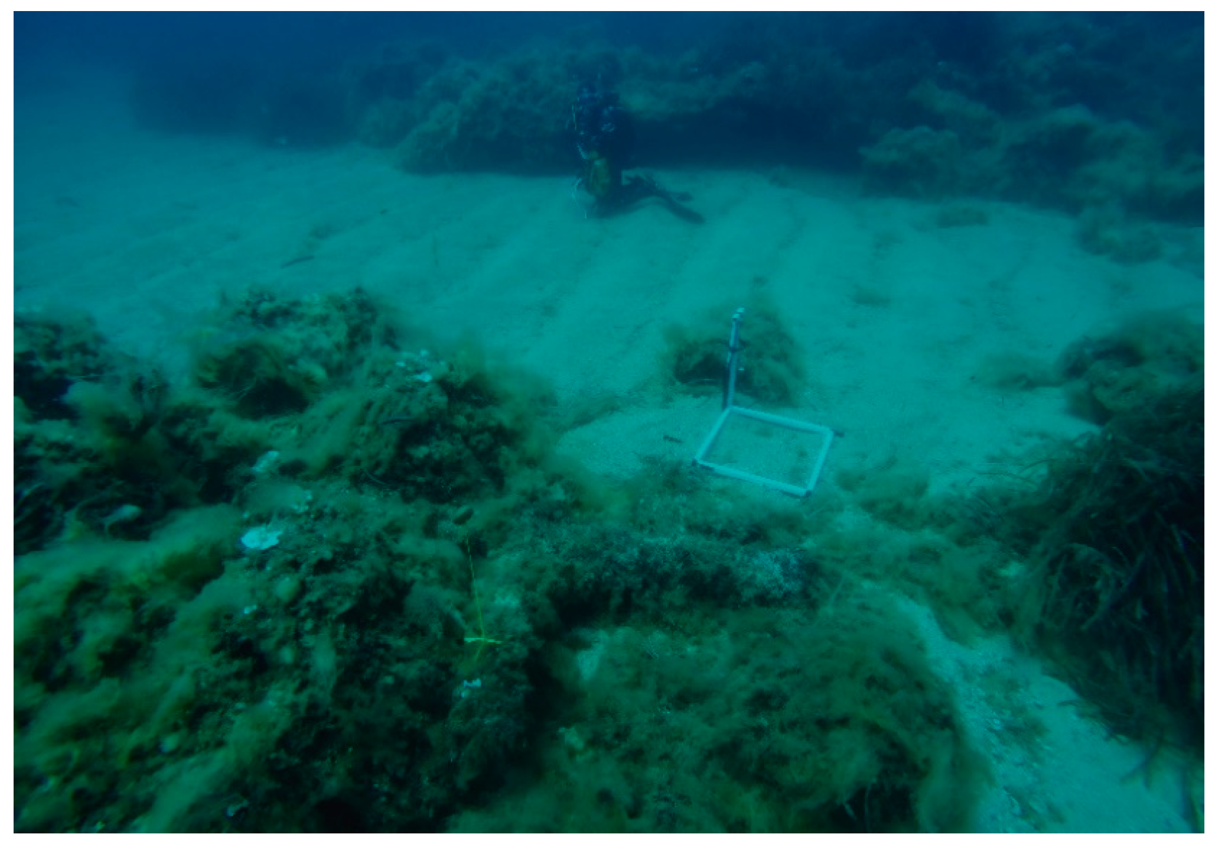
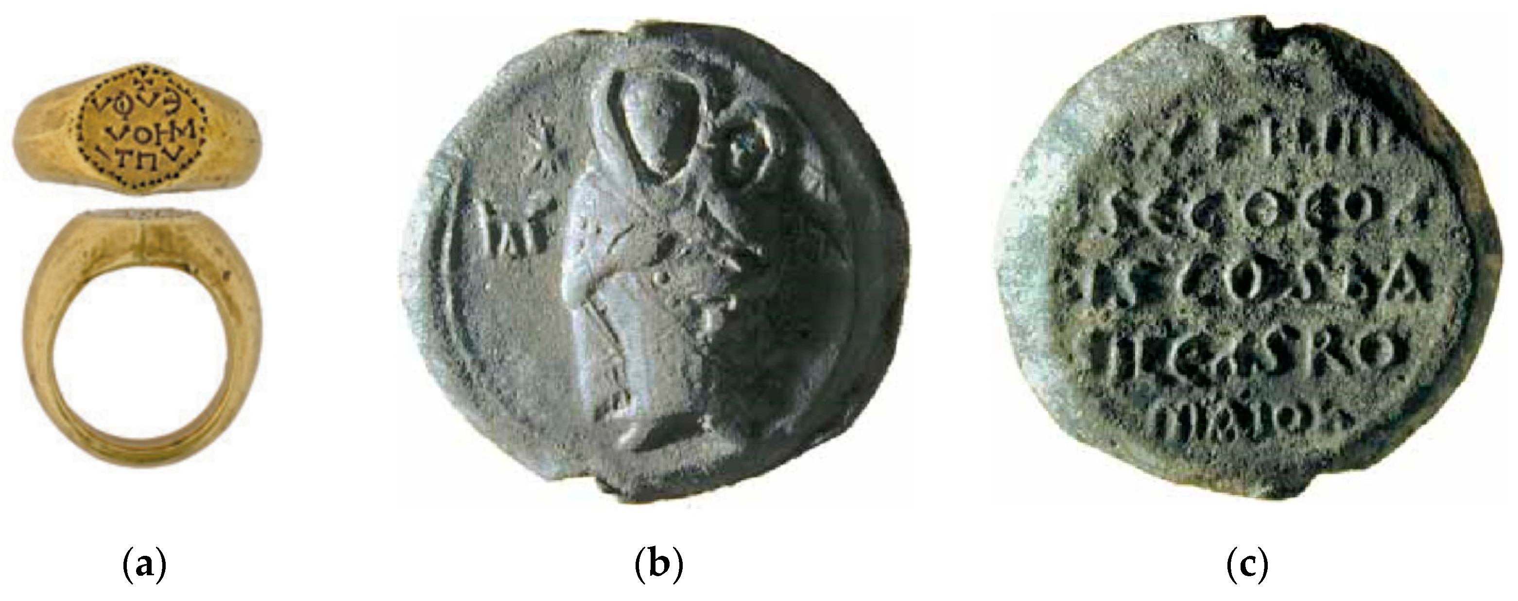
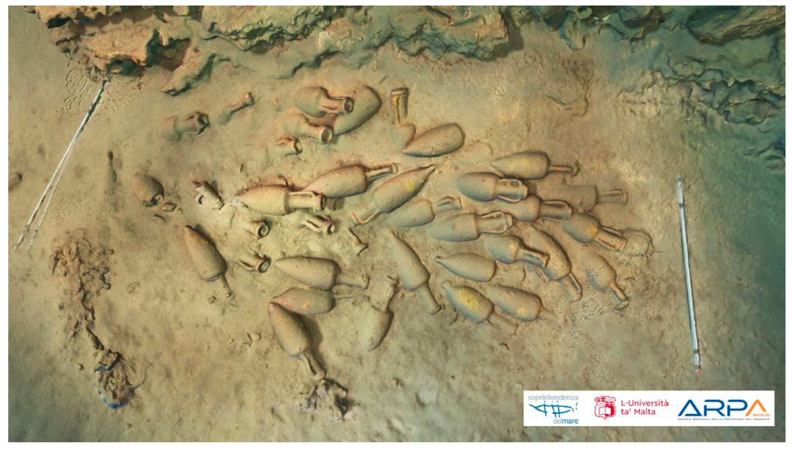
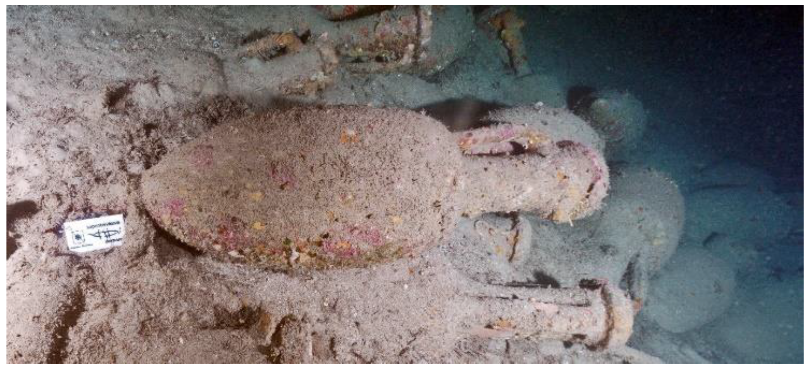
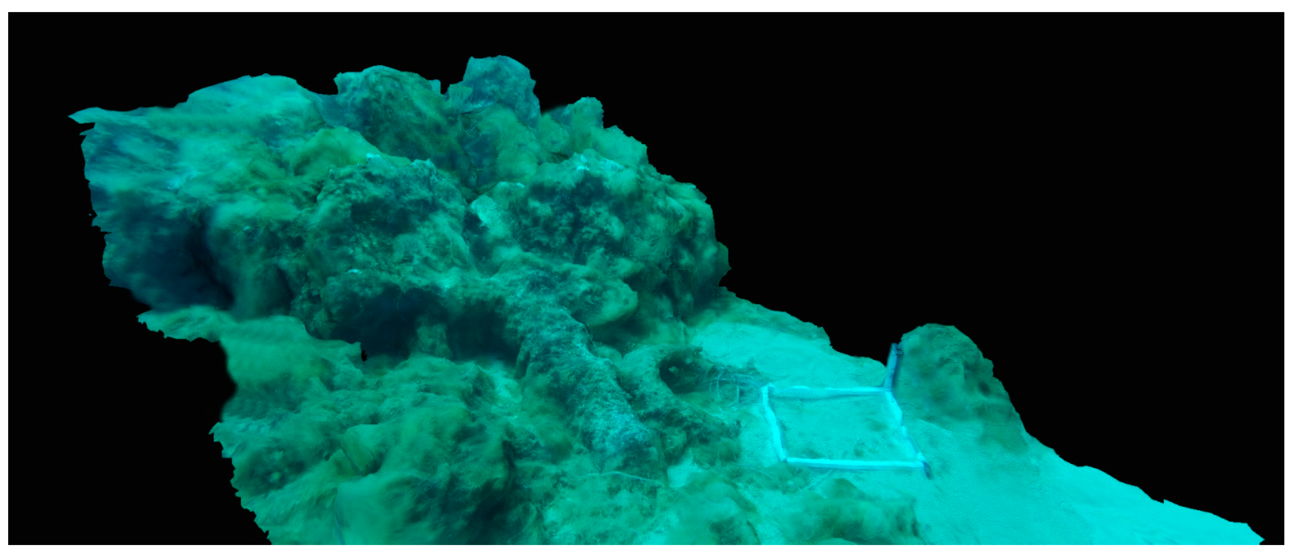
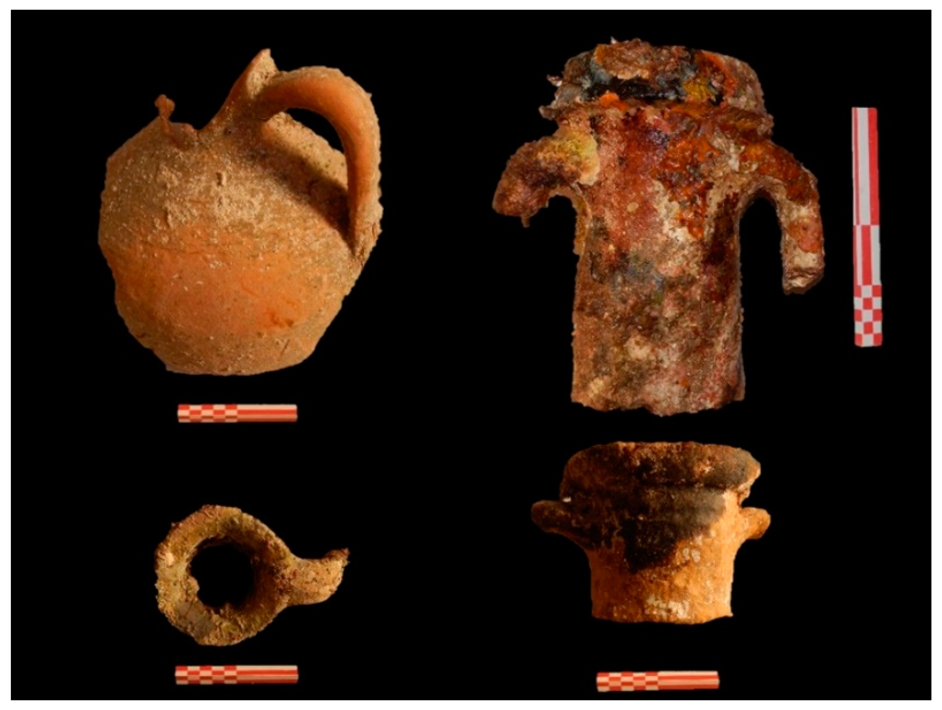
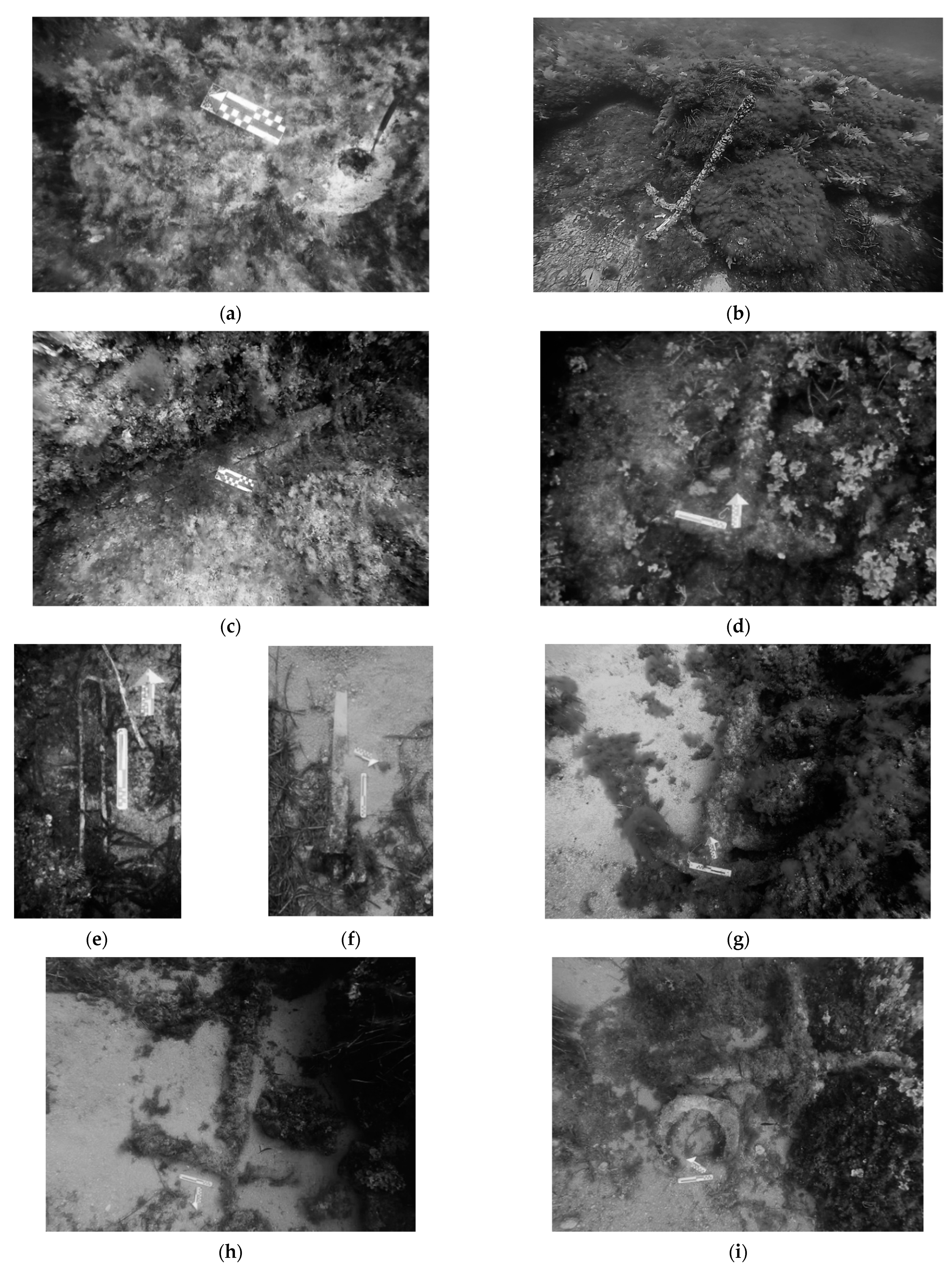
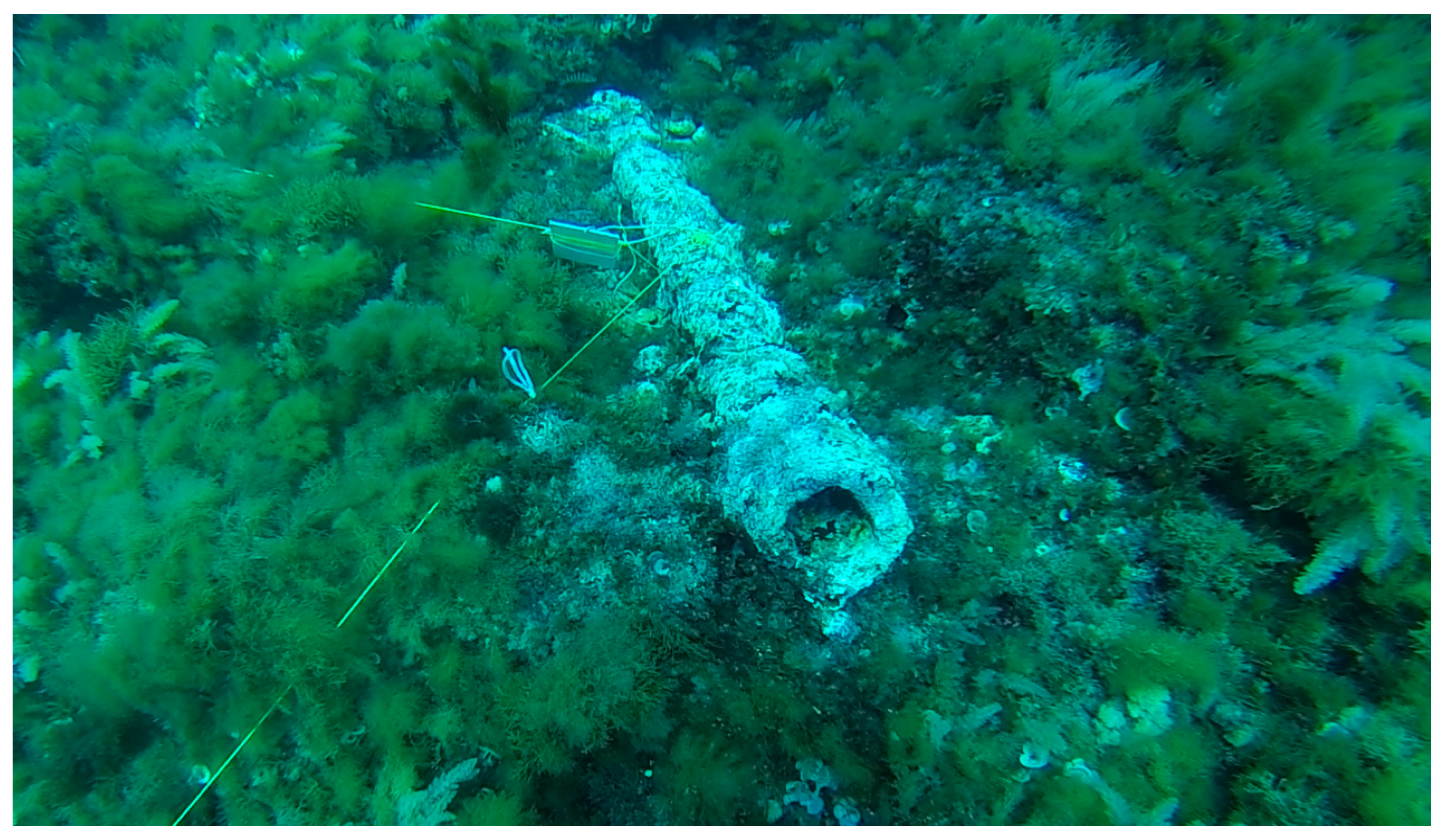
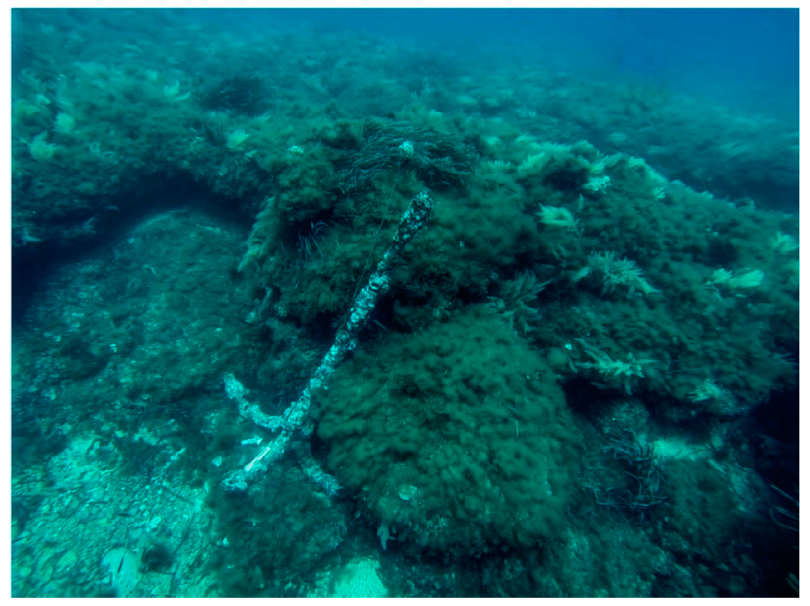
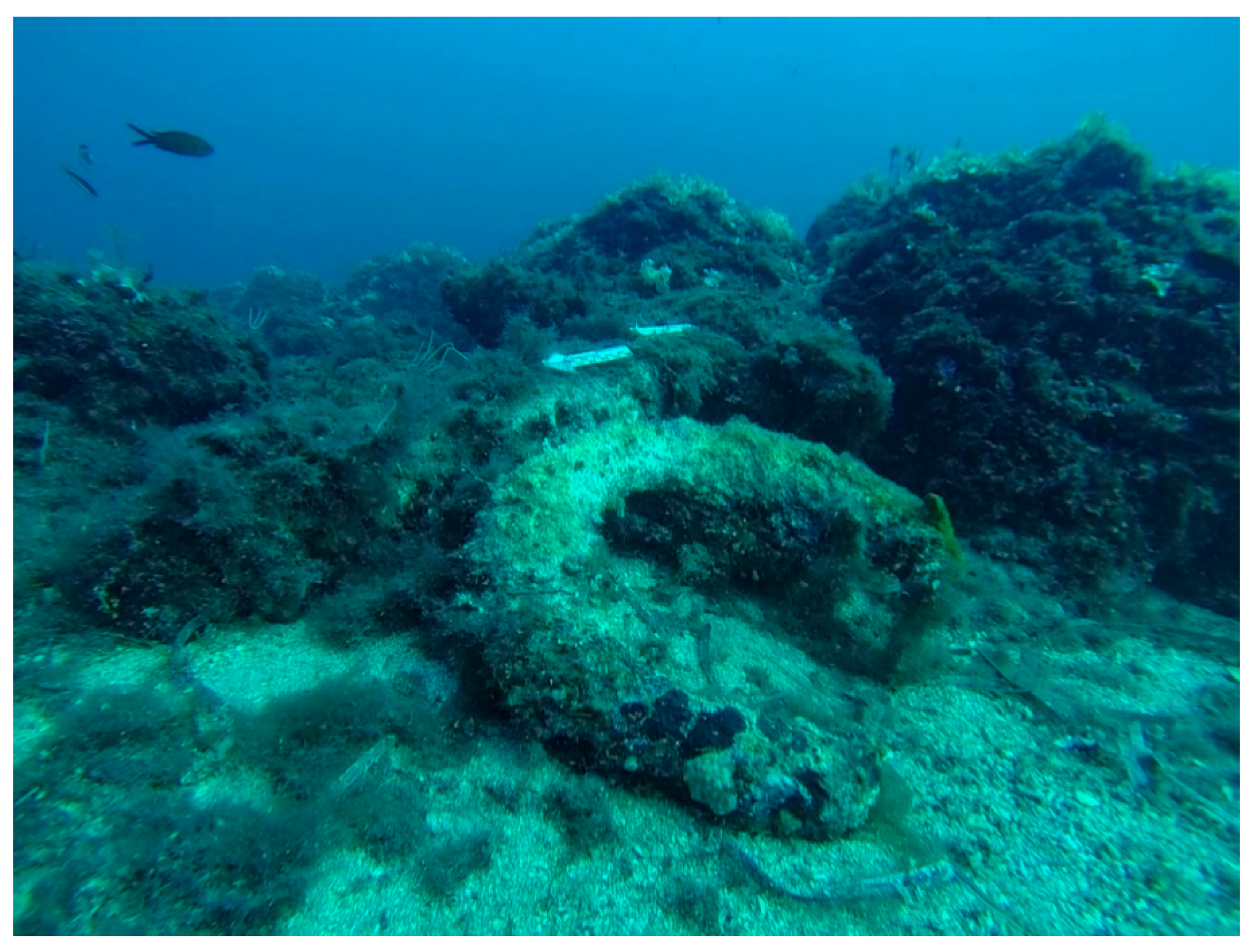
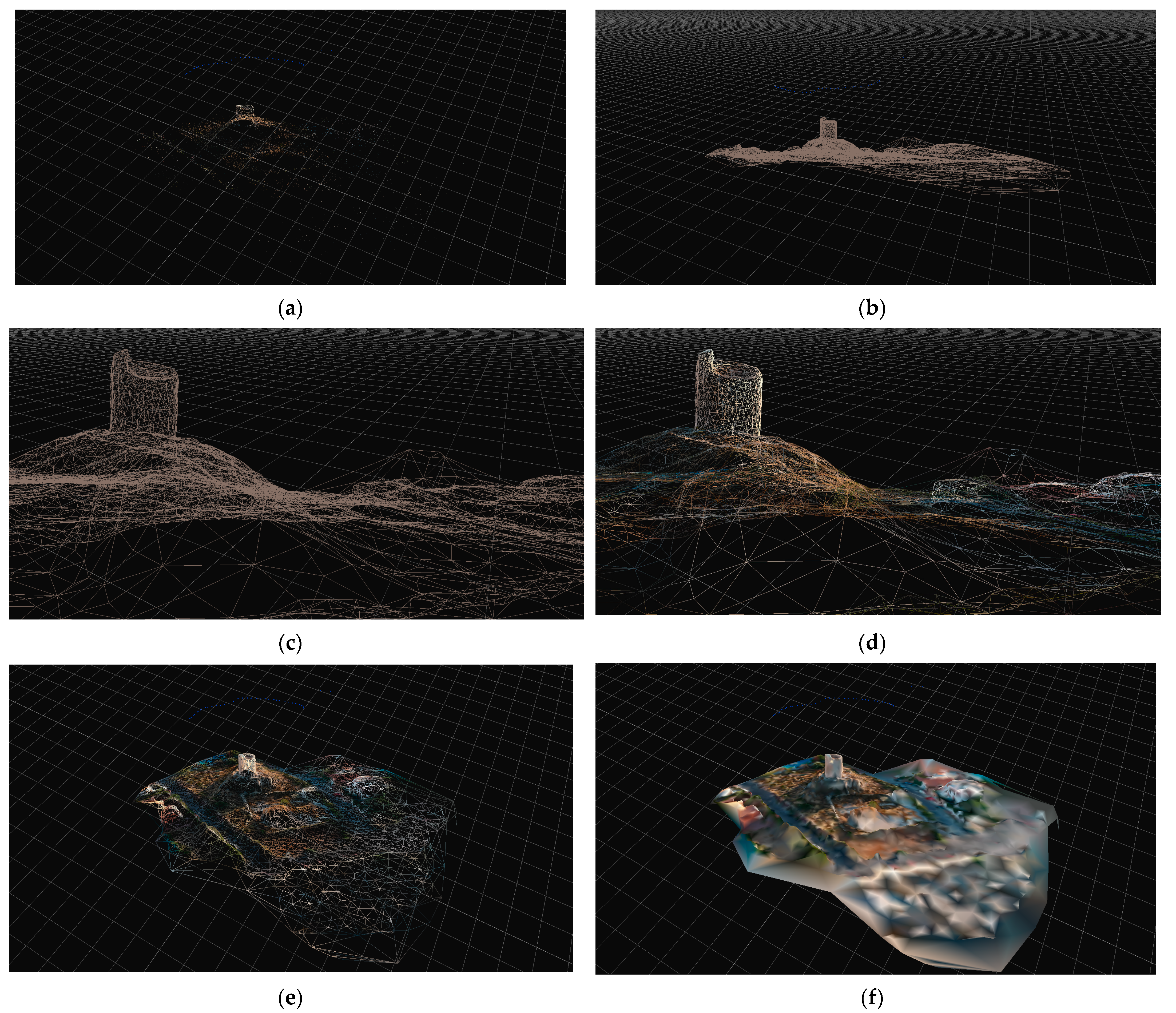
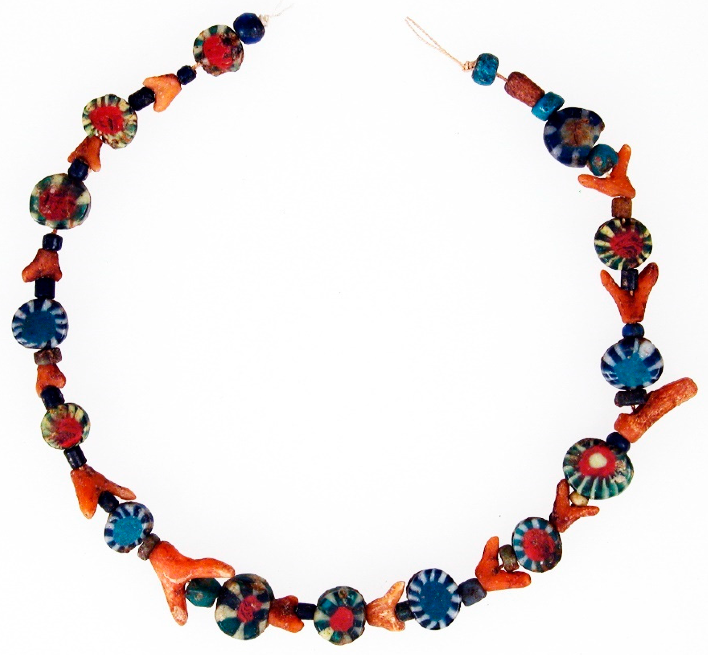
3.1. Underwater Cultural Heritage Surveys and Archaeological Finds
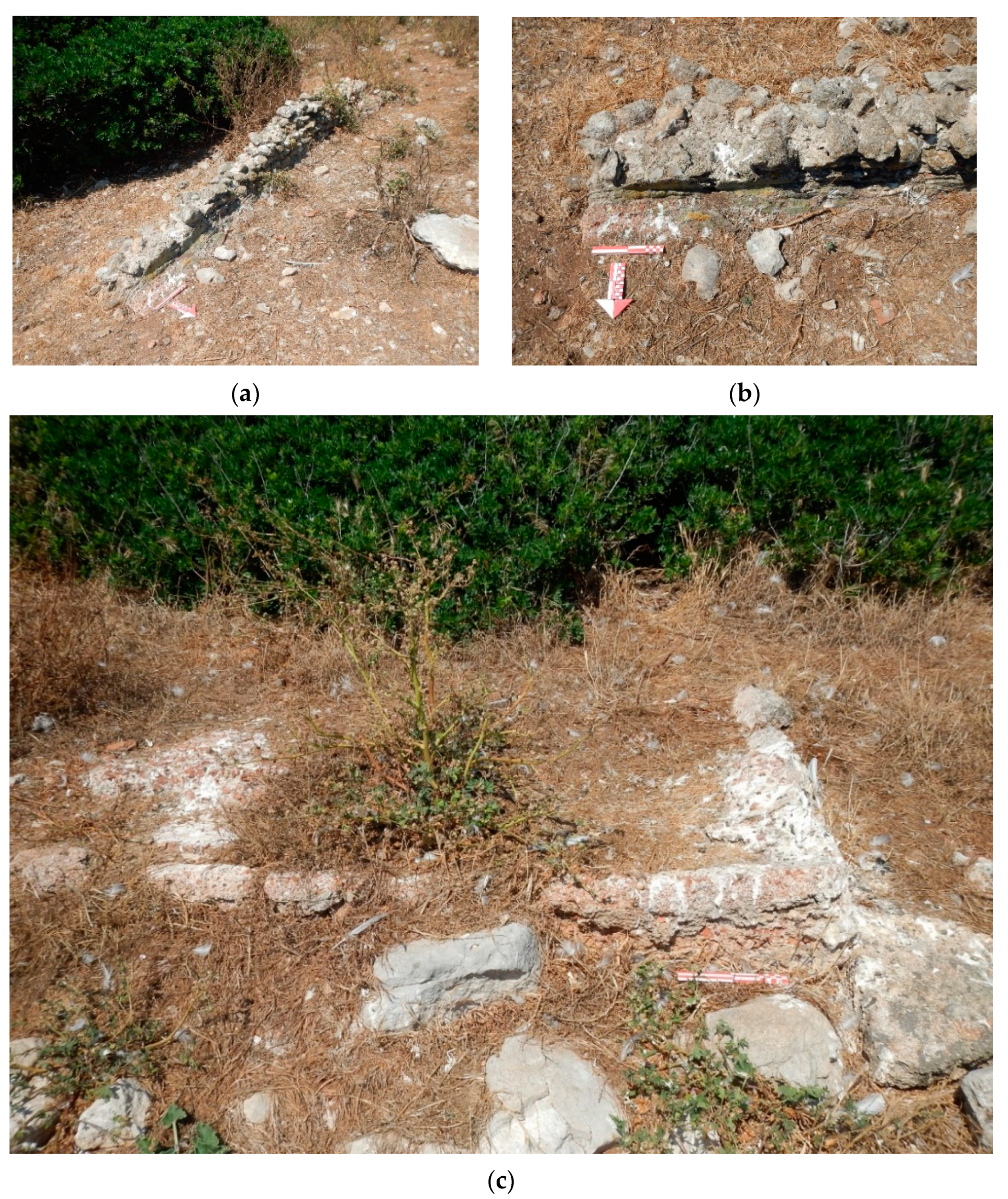
The first underwater survey campaign (June 2016) led to a first approach to the submerged waterscape of the island, from a geomorphological and archaeological point of view. Scattered and fragmentary ceramic finds were documented, belonging to different chronologies and productions. Four macro areas of an outcrop of pottery were identified (Figure 17).
Sector I, west of the island with depths between −5 and −18 m, contains pantry and kitchen containers; among the diagnostic fragments, there is a rim with a handle attachment and a medieval cooking jar with an ear handle. In Sector II, south of the is-land, close to the area of the ancient port, which exploits a small natural bay, there are fragments of Dressel 1A amphorae, which has been documented even a little further offshore, towards the channel that separates the mainland and the island. An ovoid basalt mortar pestle was found in the scattered material. Sector III, characterized by shallow water (between −1.80 and 5.00 m), reveals small, scattered fragments of tableware (mainly walls and edges), more frequent in the area in front of the fish processing tanks; the fragments, although small, seem to be attributable to the late imperial period, which is therefore in phase with the fisheries structures (see [22]). Sector IV shows scattered amphora fragments, and most portions of walls belong to at least three different types: globular, Phoenician-Punic, and Greek-Italic amphoras; together with some ribbon and rod handles, they are between −8.8 and −20.7 m in depth; two portions of a Byzantine amphora with striped interior, slightly wavy interior, and ribbon handle are in deeper water (Figure 18).
More relevant data emerged from the finds in their original position and not moved by waves or currents because of their weight: seven anchors, a cannon, and an instrument for coral fishing. Analyzing the seabed from the northwest side, on the rocky bottom we find a lead weighting bar, an iron anchor with four flukes, one anchor with two arms, a lead bar, a piece of cannon, and a lithic anchor. To the north, there are two iron anchors with two seams; to the northeast, there is a half anchor stump made of lead, the ingenium, and an iron anchor with two seams.
The metal bar (IDF_1) was found in a rock crack, northwest of the island at a depth of 10.5 m; it is a lead artifact, 150 cm long, 5 cm wide, with a thickness ranging between 5 and 8 cm; it has a convex profile and trapezoidal central section, tapered towards the ends: it is a weighting strain belonging to an anchor Kapitän 4/2a type [34] (p. 37), ascribable to the Roman period. Not far away, a metal ring for sails was found, close to an anchor with four flukes (IDF_2), identified at 18 m depth; this artifact, in a vertical position, with a tapered shaft and mutilation of the upper ring, is located against the northern wall of a sandy hole; it is equipped with four heart-shaped palms with pointed ends (height: 175 cm; stem diameter: 14–16 cm; nails of the sides: 12 cm). The object is standing about 30 m away from a bronze naval cannon (IDF_4), found at a depth of 11.3 m to the west of the island, lying down with a north–south orientation. It is in a very poor condition of conservation, broken at the extremities, and covered with calcareous encrustations and organisms (length: 158.00 cm; external diameter: 17.00 cm; internal: 10.00 cm; in the center: about 12.00 cm; thickness: 7 cm); the typology seems to be ascribable to the falconetto or emery type (comparisons in [35] and [36]) (Figure n. 14 ). The portion of the cannon, the four-fluke anchor, and the sail ring are all attributable to Renaissance or post-Renaissance galleys of medium size, whose presence in Isola delle Femmine is evidenced by some graffiti preserved on the internal wall of the Land Tower, where a boat with a square sail and vertical slits is depicted.
On the south side of this group of findings, there is a Late Antique anchor (IDF_3) with a stem preserved for a length of 100 cm (mutilated in the upper portion), a diameter of about 10 cm, perpendicular to the stem (total length: 95 cm; thickness: 15 cm; orientation: 20° N). The object is ascribable to the type Kapitän C-D [26] (p. 43). On the same side, there is also a lead anchor collar (IDF 3a—54 cm long, 8 cm wide, 1.2 cm thick) belonging to a Roman wooden anchor of which no traces remain. Along the coast, there is also a monolithic anchor (IDF_5) with an ovoid shape, at a depth of 8.6 m west of the island. The artifact is made of limestone; it has a length of 48 cm, while the width and thickness measure approximately 25 cm, a single hole with a diameter of 5 cm characterizes the artifact; this typological characteristic dates the anchor approximately between the 6th and the 3rd century BC, possibly attributable to the type Kapitän 8/3-4 [26] (p.34) or Ciabatti 16/a2 [37] (p. 46).
To the north side of the island, on a crag of the rocky bottom near MPA A Zone, there are two other Late Antique anchors. One is located at a depth of 25.7 m with an orientation of 15° N and with intact arms (IDF_6); the stem has a diameter of 16 cm, and it is 150 cm long; the maximum distance between the nails of the palms is 168 cm. A second anchor is on the seabed with an orientation of 340° N at 24.8 m depth, and it is colonized by marine organisms; it has a metal log that is 180 cm long, with a diameter of 14 cm (IDF_7). It is not excluded that the two elements probably belong to a single anchor with a fixed stock, which is documented starting from the second half of the 2nd century AD but became more widespread during Late Antiquity [38] (pp. 81–84).
The exceptional visibility in 2020 made it possible to document other important finds on the eastern side of the island: a mutilated lead anchor stock (IDF_8), an instrument for coral fishing (IDF_9—ingenium), and another proto-Byzantine anchor (IDF_10), oriented 250° N. The ingenium lies on the bottom of the sea, mutilated on one of the arms; the intact east–west body measures 165 cm, and the southwestern arm is mutilated and measures 80 cm (thickness between 15 and 20 cm); it was equipped with a recovery ring (diameter: 43 cm; crown thickness: between 5 and 7 cm). The instrument is attested at a short distance from a large anchor Kapitän 8/d type, oriented 180° N, with a shaft 120 cm long. The shaft has a diameter of 12 cm, and the flukes are 15 cm. The artifacts do not necessarily belong to the same phase; however, the great cruciform tool could be ascribable to ancient epochs.
A photographic conspectus of the finds is reported below (Figure 19).
The survey and the documentation let us plan and realize two new underwater archaeological itineraries: one for “open divers” at a basic level, and one for advanced, respectively, on the west and east side of the island. In the first itinerary, starting from the cannon, at a depth of 12 m, we swim towards the anchor with four palms in a north-northwest direction, and then return to the south side, near the late Roman anchor at −18 m, observing Islamic and Late Roman pottery fragments, together with remarkable elements of geological and biological interest. The track, provisionally marked with 14 stages and about 200 m long, closes on the initial cannon and can be completed in 40 minutes in the safety curve. The second itinerary is deeper and dedicated to medium expert divers at a depth of 25 m where we find Roman and Late Roman anchors, the ingenium, and some fragments of the amphora.
At the current state of research, the maximum concentration of the finds is between −10.00 and −25.00 m in depth, corresponding to the so-called second and third geomorphological cliff. The study of the percentage breakdown by the chronology of the diagnostic findings shows how the Late Antiquity-Proto-Byzantine phase seems to be one of the most attested historical periods. The finds must be linked to anchoring and mooring activities near the island, used as shelter from bad sea weather conditions; the artifacts also suggest commercial exchanges related to the local fisheries industry. The systematic continuation of the investigations will certainly clarify the archaeological framework.
In this extraordinary context, we decided to concentrate our detection on two main artifacts to be related to historical Built Heritage (the towers).
On the bottom of the sea, we focused our attention on two finds on the west side of the island: the cannon (Figure 20) and the four-fluke anchor wedged in the rocks (Figure 21), and on the east side of the island, the extraordinary tool for coral fishing—the ingenium (Figure 22).
The photogrammetric survey allows us to measure the findings even at university, without returning to the underwater site; the process of investigation and analysis of the artifacts can continue indirectly even after diving, giving us the possibility to verify the data and size of all the artifacts, including geological and biological measures, working on comparison with a similar object, individuating the right chronology.

3.2. Built Heritage

Waterscape archaeology studies, as mentioned, associate geomorphological data with historical evidence, both on land and on the seabed, for a better understanding of the environmental context and full comprehension of historical evolution.
We have already analyzed the geomorphological profile through the Google Earth “show elevation” function. This simple process allowed us to verify the large gap in relation to the heights of the two towers, placed on lookout points (Figure 23a,b).
In the ambit of our geomatic studies on coastal landscape, we were aided by a video published two years ago by A. Minneci [39], reporting the flight of a Dji Spark aerial drone. We have transformed the film into images and processed the images through the software Zephyr Free. This allowed us to extract geomatic surveys relating to the two buildings still on site: the Land Tower and the Sea Tower. Thanks to the 360° views and zenith overflight, it was possible to complete the photogrammetry and some 3D models of the structures.
The study of the differences in altitudes, and the analysis of the perspectives of visibility from the coast and from the island, confirms some previous studies relating to coastal towers carried out by F. Maurici [40,41], who analyzed the towers from a historical-architectural point of view, including construction methodologies and techniques.
Our contribution to the 3D survey gave the possibility of some checks on the state of conservation and the planning of restorations. The Sea Tower is in a very poor, precarious condition: it is partially collapsed, and as can be seen from the photos and the 3D model, there is no maintenance.

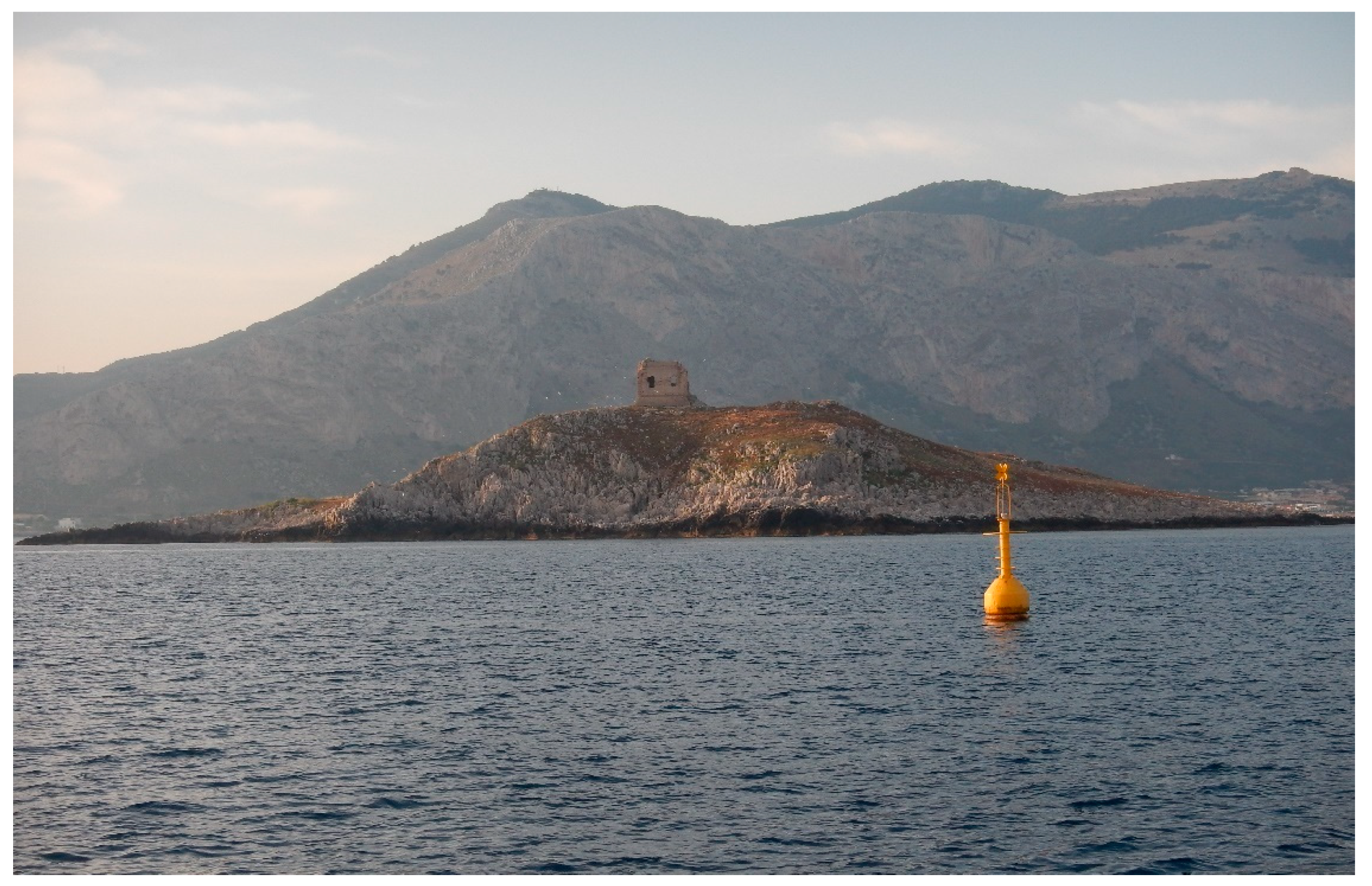
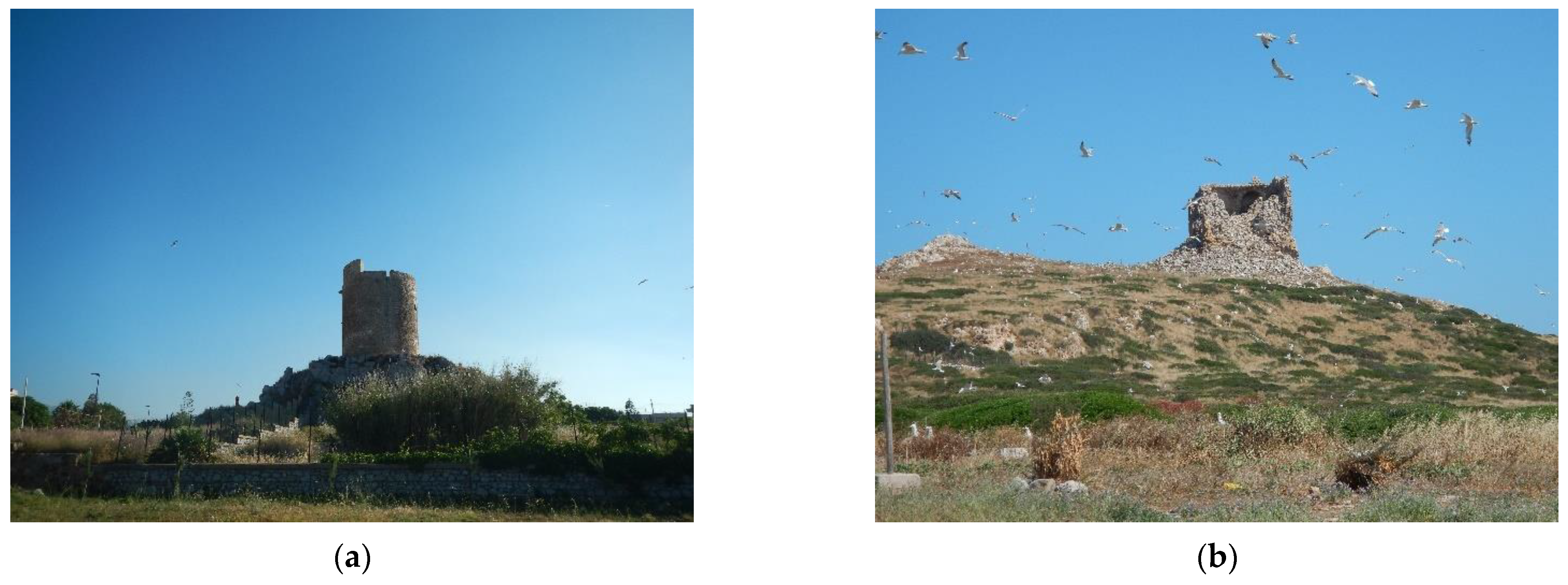
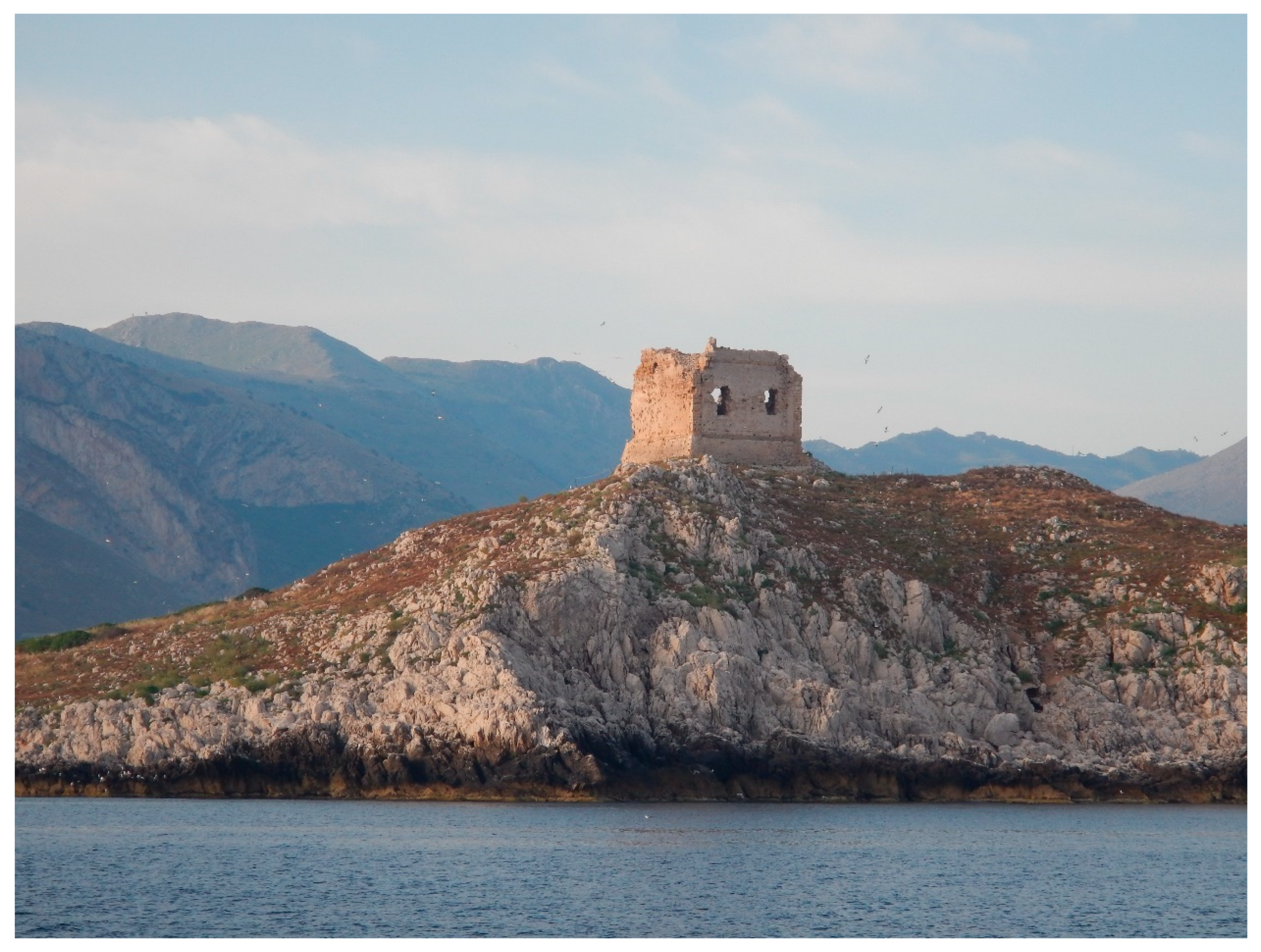
3.2.1. The Sea Tower

The Sea Tower stands on one of the two highest points of the small island, about 35 m above sea level; this position, strategic also due to the natural slope of the island, allowed the garrison of the tower to effectively monitor all the surrounding sea space and to maintain visual contact with the other nearby coastal towers. The structure seems to date back to 1584, the result of a restoration by the architect Camillo Camilliani of a tower already mentioned by Tiburzio Spannocchi, a military architect during the Late Renaissance; the fortified structure was built by the end of the 16th century (Figure 24).
The “camillane” type of tower is characterized by a pseudo-quadrangular plan, a base up to 2.50 m high, a ground floor with a slope of about 3 m, and an upper floor with a terrace with a canopy. The structure is made of blocks and molded elements of limestone as regards architraves, jambs, string courses, cantonal, and vaults; the masonry masses are instead made up of barely hewn ashlars of the same material. The tower had to have an original height of about 18 m from the ground level, while the longest side measured 16.50 m in the wider base sector. The access door opened on the first floor and was served by a retractable wooden flying staircase; only later was an external masonry staircase added (visible in some photos from the 1920s). This south side is completely collapsed and covers the ground floor with its rubble; in watercolor by Camilliani, however, it is visible how the door was protected by two machicolations, one at three-quarters of the wall and the second on the terrace. On the opposite side of the building, towards the north, the facade is still partially preserved, and it has two openings at the level of the first floor; the superior frame, part of the parapet, and two corbels on the north corner are still visible. On the same side, the ground floor has a base with a vertical profile, an inclined shoe, a frame, and eaves. The northeast side, less preserved than the previous one, has the same architectural elements except for the windows. The southeast side is instead in complete ruin; the external walls of the upper floors are collapsed, and the first-floor shoe is covered with debris.
The ground floor was divided into four vaulted rooms, which could be accessed from hatches on the floor of the first level; three rooms were used for the storage of food, while another one was used as a cistern for the rainwater. The first floor was divided into three rooms: two smaller with two large windows for housing the garrison, and a larger one, that served as a common area and entrance. All the openings of the building, both internal and external, were surmounted by arches with three centers, and all the rooms were covered by barrel vaults arranged in such a way as to distribute the static loads. On the western side of the first floor, just above the cistern, there was a wood stove, and above it, a window; in front, supported by a rampant arch, rose a flight of stairs that led to a wooden mezzanine. The same staircase also led to two other ramps which were instead carved into the thickness of the perimeter walls leading to the terrace. The terrace was divided into two parts: one with a roof, towards the ground, and the other uncovered towards the sea. The first was used to repair artillery pieces, ammunition, and gunpowder, kept under lock; the other half was accessible from the part with a canopy through a large door with a round vault and constituted the area of the tower where the guards were carried out. The original structure of the tower was heavily distorted by additions and changes made at the end of its military function or, in any case, after the end of the long period of the barbarian raids. These changes consist of the construction of an external brick entrance staircase and two openings on the ground floor, respectively, to the south and west, both with their access stairs. In a more recent period, perhaps towards the end of the 18th century, the entrance staircase was enlarged, and a parapet was also built [40,41]. The remains of the tower still standing were the subject of our indirect survey.
The video made with the aerial drone gave us the chance to detect the remains of the external part, the collapse of the interior architectural features, and the collapse of the elevated part, located mostly on the south side of the tower, as we can see from the photos and the models (Figure 25).

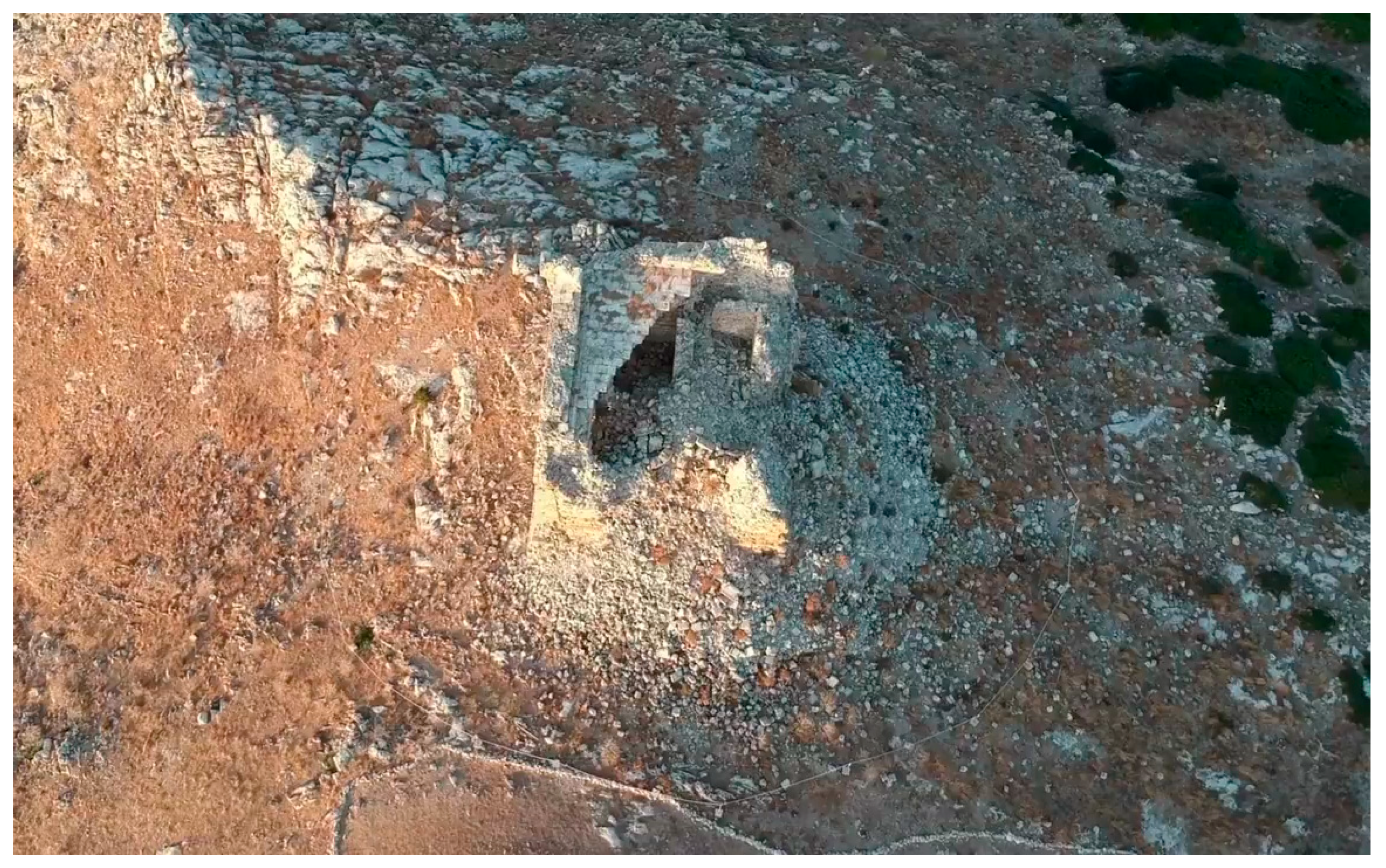
3.2.2. The Land Tower

The Land Tower has undergone recent conservation activities and can be visited if accompanied by the local officers. For the completeness of the studies, we have included in our geomatic survey the tower with the portion of rock on which it is built (Figure 26).
The tower has a cylindrical shape, devoid of shoe and recesses; the internal walls are made of limestone and strong sandstone ashlars, covered externally with small, squared blocks of the same material; this wall texture has also been exposed by recent restorations. The ground floor is characterized by 2.20 m thick walls enclosing a single compartment, originally used as a cistern; the rainwater was collected here directly from the upper terrace through a terracotta conduit embedded in the wall. The upper floor is accessible from a small door which was reached by a flying staircase originally defended by a machicolation which recent restorations have definitively removed; today, the flying staircase has been replaced with a fixed wooden staircase for visitors. The only room on the upper floor is covered by a domed ceiling with an oculus at the top; it has a window with jambs and architrave in freestone, surmounted by an unloading arch. This opening is located on the northern side of the tower, fronting the access to the floor on which it is located, allowing control of a large stretch of sea and the small island just in front of it. Next to the window there is still a graffiti drawing depicting a small galley under a full sail. A narrow stairwell (70 cm) obtained in the wall thickness leads to the top terrace; it is crowned by a parapet on which there are three compartments probably used for small caliber 8 guns [40,41].
The three-dimensional geomatic model allows us to appreciate the restored structure in its proportions in relation to the landscape context, showing its important location on the highest topographical point of the promontory, the Punta del Passaggio, certainly a strategic site for sightings (Figure 27).

4. Discussion

Thanks to our work, we completed a cultural heritage database of the Isola delle Femmine district, connecting terrestrial and underwater data.
The geomatic surveys, combining diving and flights, created the prerequisite for the realization of new underwater itineraries with a close connection to the surrounding landscape. To understand anthropic development and seafaring activities, we started with diving surveys, then conducted preliminary bibliographic studies and examination of the geological context, to arrive at the documentation of the submerged heritage with standard and innovative methodologies.
Our new approach to involving students in research through teaching, even with diving, has been successful for the large amount of data collected.
The 3D models of some remarkable finds and areas of particular interest were also chosen to create an environmental reconstruction that could be useful for beginner divers, as well as experts, in approaching the site. Three-dimensional models with animation and video can be adopted in the didactic of underwater archaeology to understand exactly the geomorphological context in which they will swim, for example, offering useful data to plan the dive in detail. Therefore, even the diving guide can define a visit path that is congruent with the abilities of the divers accompanying them; the 3D modeling is also useful for evaluating with clients and customer immersions, with the kind of visit depending on archaeological, geological, biological or photographical interest.
The photogrammetry and 3D geomatic documentation is a multifunctional tool, preserving the measurements of all the findings: they let us detect and verify in the future the corrosion, the possible damage of the structures, and the findings, deriving from the storms, the wind and water erosion, and the bio-organogenesis. The geomatic survey allows us to program and plan interventions of protection and maintenance, monitoring the objects and the structure across the years. Built heritage and submerged heritage coexist on different levels, but they can easily interact. Underwater tourism and land tourism are indeed compatible. A visit to the natural oasis on land is compatible with a freediving itinerary, as well as scuba immersion.
The waterscape archaeology concept and our integrated multidisciplinary approach generated a model of studies with a new perspective directed also to public archaeology and citizen science.

5. Conclusions

5.1. Historical and Technical Considerations

The findings detected on the west side of the island can be traced back probably to a galley armed with a falconet-type cannon, equipped with a four-fluke anchor, and sails supported by cables with passing rings. Relevant iconographic evidence is found inside the Land Tower on the wall: the graffito depicting a small galley with a mainsail and foredeck made with vertical sailcloth, highlighting the relationship between built cultural heritage and submerged cultural heritage, the witness of the boat which moored on the western side of the island (Figure 28).
The comparison of the 3D models between the two towers highlights the different methodologies and construction techniques across history, showing continuity of life on site, from antiquity to the present day. With the documentation of the collapse of the structures of the Sea Tower detected with the 3D model, it will be possible to quantify the material available for planning the reconstruction of the building with the same stones that made up the tower in the past; in this sense, it represents the possibility of having a metric calculation of the availability of stones useful for the restoration of the structure, with original elements (Figure 29).
The photogrammetry and 3D model of the anchor and the cannon allow the studies regarding the measurements and proportions of the reconstruction of the galley to be completed by nautical archaeologists specializing in the study of boats (work in progress at the Underwater Archaeology Laboratory).
Regarding the tool for coral fishing, the ingenium, found on the east side, is today a unique exemplar almost in its entirety, which could be attributable to some economic aspects important for local history by relating the submerged, material, and immaterial cultural heritage in the ambit of customs and traditions. Together with the halieutic industry, coral fishing was also one of the attested activities at Isola delle Femmine during the Late Antiquity (biological data also confirms the actual presence of coral at about 54 m depth).
Coral has been known since ancient times, as well as during the Imperial Period, the Late Antiquity, and Middle Ages, for its apotropaic and therapeutic properties (see Isidore of Seville, Etymologiae, XVI, VIII.1); it was used in the production of jewels, as we know from the literary sources and the archaeological finds (Figure 30), an element that is well suited to the history of Turmarca Euphemius and his passion for women, as the literary sources report.

5.2. Implementation for Sustainable Archaeological Diving

The great work of integrated surveys, documentation, and 3D modeling will allow for greater development of coastal tourism; the constantly updated database will provide didactic support for diving and will facilitate scientific and educational briefings.
Therefore, before each dive, it will be possible to experience a virtual immersion in a three-dimensional environment, to receive all the useful instructions for a correct visit both from a technical and a scientific point of view, with maximum respect for the environment and the cultural heritage, following the principle of the UNESCO Convention, first “conservation on-site” [42]. Sharing the ideas of the European Blue Growth Strategy, supporting sustainable growth in the marine and maritime sectors, drawing attention to the operation of Accessible Underwater Cultural Heritage Sites (AUCHS), and promoting sustainable protection, the project will plan new activities in all the MPA with innovative solutions and best practices developed and adopted by local, regional, national, or transnational actors, following their respective regulatory frameworks concerning the protection of UCH, including the ratification of the 2001 UNESCO Convention on the Protection of the Underwater Cultural Heritage (see [43,44,45,46,47,48]).
The project, always following the theme of zero pollution, aims to develop archaeo-snorkeling and archaeo-freediving in shallow water, as good practices for an excellent approach to the sea and the surrounding environment. Implementing sustainability practices in underwater itineraries and diving centers, this new approach can be applied and replicated anywhere, promoting maximum visibility and knowledge of the archaeological submerged and open-air heritage.
The great opposrtunity of Isola delle Femmine is the possibility to have an overall view of history just with a swim. We are completing the project with a series of videos relating to the underwater documentation, 3D animations of the main diving points, and synoptic sheets containing the main useful data for archaeological dives and guided tours.
The scientific synergy between the Superintendence of the Sea, the Underwater laboratory of the Cultural Heritage Department of the University of Padua, and the CMAS Federation ITAF07 has shown how it is possible to carry out an exhaustive investigation of the submerged areas through classics studies, associated with modern techniques such as digital photogrammetry and 3D modeling; the project has favored the training of young students who are now able to appreciate how the study of the classical disciplines can be extraordinarily combined with contemporary instruments and software and can be open source or low cost without neglecting the training for scientific diving developed in safety conditions. This underlines how classical studies lend themselves to scientific interaction and still constitute the basis of archaeological research, developing and deepening through geomatics.
All the participating students continued their studies through degree theses, and they are working on processing all the acquired data. In the following months, the updates of the results will be published with the completion of the photogrammetric and three-dimensional models of the entire research area.
A holistic approach to waterscape archaeology, connecting underwater archaeology with coastal built heritage, has experimented with successful results, gathering, storing, processing, and delivering spatially referenced information. Beyond the didactic aspect which saw the participation of a total of over one hundred students, we underline that the systematic collection of data will make it possible to take samples to analyze the state of conservation and work for a better in situ preservation of the artifacts and the structures, as the UNESCO Convention requires.

Funding

The project took place thanks to the signing of 2 memoranda of understanding: the first between the Superintendence of the Sea (Palermo, Italy) and the Federation ITA F 07 (Bologna, Italy), signed on 9 October 2015, renewed with Prot.3320, 30 December 2020; the second between the Federation and the Cultural Heritage Department of the University of Padova, Rep. n. 53/2017, Prot. no. 419, 28 March 2017, renewed with Prot. no. 718, 6 April 2020.

Data Availability Statement

Isola delle Femmine MPA, Ministero della Transizione Ecologica: https://www.mite.gov.it/pagina/area-marina-protetta-capo-gallo-isola-delle-femmine (accessed on 9 September 2022); Geological Map, Istituto Superiore per la Protezione e la Ricerca Ambientale: https://www.isprambiente.gov.it/Media/carg/note_illustrative/585_594_Partinico.pdf (accessed on 9 September 2022); Deep water research at Isola delle Femmine (PA), Italy, Regione Siciliana, Assessorato regionale dei Beni culturali e dell’Identità siciliana, Dipartimento dei Beni culturali e dell’Identità siciliana, Soprintendenza del Mare: https://www2.regione.sicilia.it/beniculturali/archeologiasottomarina/; https://www.facebook.com/sopmare (accessed on 9 September 2022).

Acknowledgments

Our greatest gratitude to the Superintendents Sebastiano Tusa †, Valeria Li Vigni, and Ferdinando Maurici, together with the functionaries Roberto La Rocca, Antonella Testa, Pietro Selvaggio, Fabrizio Sgroi, and Salvo Emma, the Honorary Inspector Gaetano Lino, the biologists and diving instructors Vincenzo Raimondi, Carmelo D’Avola, Dario Sanfilippo, Mauro Assenzo, Gian Pietro Geraci, Tony Scontrino, and Alberto Scontrino, and to the students who have been working with us Alberto Nicolè, Mirta Schievano, Antonio Duccoli †, Claudia De Giorgi, Giorgio Pighi, Salvatore Agizza, Lucio Andrioli, and Gabriele Spano.

Conflicts of Interest

The authors declare no conflict of interest.

References

  1. Bucci, G. Coastal Zone Culture: Towards a hermeneutic of Waterscape Archaeology. In Proceedings of the International Conference on Coastal Ecosystem and Management, Expert Opinion on Environmental Biology, Amsterdam, The Netherlands, 16–17 September 2019; p. 15. [Google Scholar]
  2. Balletti, C.; Beltrame, C.; Costa, E.; Guerra, F.; Vernier, P. Underwater photogrammetry and 3D reconstruction of marble cargos shipwreck. In Proceedings of the International Archives of the Photogrammetry, Remote Sensing and Spatial Information Sciences, Underwater 3D Recording and Modeling, Piano di Sorrento, Italy, 16–17 April 2015; pp. 7–13. [Google Scholar] [CrossRef]
  3. Menna, F.; Nocerino, E. Hybrid survey method for 3D digital recording and documentation of maritime heritage. Appl. Geomat. 2014, 6, 81–93. [Google Scholar] [CrossRef]
  4. Nocerino, E.; Menna, F. Photogrammetry: Linking the World Across the Water Surface. J. Mar. Sci. Eng. 2020, 8, 128. [Google Scholar] [CrossRef]
  5. Catalano, R.; Basilone, L.; Maggio, C.D.; Morticelli, M.G.; Agate, M.; Avellone, G.; Contino, A.; Valenti, V.; Vaccaro, F.; Lena, G.; et al. Note illustrative della Carta Geologica d’Italia alla scala 1: 50.000, foglio 594–585, Partinico-Mondello Progetto CARG-ISPRA Ambiente; 2013. Available online: https://www.isprambiente.gov.it/Media/carg/note_illustrative/585_594_Partinico.pdf (accessed on 9 September 2022).
  6. Antonioli, F.; Chemello, R.; Improta, S.; Riggio b, S. Dendropoma lower intertidal reef formations and their palaeoclimatological significance, NW Sicily. Mar. Geol. 1999, 161, 155–170. [Google Scholar] [CrossRef]
  7. Pititto, F.; Torchia, G.; Catalano, D.; Greco, R.; Pelusi, P. Cartografia biocenotica di dettaglio delle “zone a” di un’area marina protetta mediante strumenti tecnologicamente avanzati. Biol. Marittima Mediterr. 2006, 13, 413–422. [Google Scholar]
  8. Uggeri, G. La viabilità della Sicilia in età romana. J. Anc. Topogr. Suppl. 2004, 144–148. [Google Scholar]
  9. Uggeri, G. Proposta di Inquadramento Diacronico dei castra bizantini della Sicilia. In La Sicilia Bizantina Storia, Città, Territorio. Triskeles. Caltanissetta; Feltrinelli: Milano, Italy, 2010; pp. 189–205. [Google Scholar]
  10. Mercadante, F. Da Balarm Palermo a Giazîrah isola: Il Porto di Gallo Ritrovato: Analisi Storico Ambientale Degli Approdi del Medioevo Arabo-Normanno Nel Territorio ad Occidente di Palermo Dall’itinerario Geografico di al-Idrīsī: Barqa, Marsà ạt-ṭīn, Ghālah, Giazîrah; Edizioni del Mirto: Palermo, Italy, 2001. [Google Scholar]
  11. Milanesi, L. Dizionario Etimologico della Lingua Siciliana, s.v. Isola delle Femmine; Mnamon: Trapani-Milano, Italy, 2012; pp. 5–6. [Google Scholar]
  12. Patitucci, S. Per una periodizzazione dell’insediamento bizantino nella Sicilia Orientale V Congresso Nazionale di Archeologia Medievale; All’Insegna del Giglio: Firenze, Italy, 2009; pp. 272–278. [Google Scholar]
  13. Maurici, F. Breve storia degli arabi in Sicilia; Flaccovio: Palermo, italy, 2006. [Google Scholar]
  14. Prigent, V. Pour en finir avec Euphèmios, basileus des Romains. Mélanges de l’École française de Rome. Moyen-Age tome 2006, 118, 375–380. [Google Scholar]
  15. Drocourt, N. Christian-Muslim diplomatic relations. In Christian-Muslim Relations, A Bibliographical History Volume 2 (900-1050); Thomas, D., Mallett, A., Roggema, B., Eds.; Brill: Leiden, The Netherlands, 2010; Volume 14, pp. 29–72. [Google Scholar]
  16. Wortley, J. John Skylitzes: A Synopsis of Byzantine History, 811–1057: Translation and Notes; Cambridge University Press: Cambridge, UK, 2010; pp. 811–1057. [Google Scholar]
  17. Spatafora, F.; Gandolfo, L. Il Salinas ricorda Salinas 1914–2014, Museo Archeologico Regionale “Antonino Salinas”, Palermo 8-07/4-11/2014. Assessorato dei Beni Culturali e dell’Identità Siciliana, Dipartimento dei Beni Culturali e dell’Identità Siciliana; Regione Siciliana: Palermo, Italy, 2014. [Google Scholar]
  18. Cosentino, G.C. L’architetto e l’arabista. Un Carteggio Inedito: Francesco Saverio Cavallari a Michele Amari (1843–1889) Trascrizione e Note di Giuseppina Sinagra; Regione Siciliana: Plaermo, Italy, 2012. [Google Scholar]
  19. Maurici, F. Sicilia bizantina: Gli insediamenti del palermitano. Arch. Stor. Sicili. 1994, 20, 27–94. [Google Scholar]
  20. Maurici, F.; Fresina, A.; Militello, F. Le Torri Nei Paesaggi Costieri Siciliani (Secoli XIII–XIX) Vol. 1–3; Regione Siciliana: Palermo, Italy, 2008. [Google Scholar]
  21. Lo Faro, A.; Rodríguez-Navarro, P.; Santagati, C.; Mangani, M. Coastal towers in the Mediterranean of XVI century: A comparison between Sicilian and Valencian cases. In Defensive Architecture of the Mediterranean. XV to XVIII Centuries/ Vol VI: 329–336; Avilés, G., Ed.; Editorial Publicacions Universitat d’Alacant: Alicante, Spain, 2017. [Google Scholar]
  22. Purpura, G. Pesca e stabilimenti antichi per la lavorazione del pesce in Sicilia: II-Isola delle Femmine (Palermo), Punta Molinazzo (Punta Rais), Tonnara del Cofano (Trapani), San Nicola (Favignana). Sicil. Archeol. 1985, 18, 59–96. [Google Scholar]
  23. Purpura, G. Rinvenimenti sottomarini nella Sicilia Occidentale. Archeol. Subacquea3, Supplemento al n. 37-38/1986 del Boll. d’Arte del Minist. per i Beni C. e Ambient.i 1986, 139–160. [Google Scholar]
  24. Tusa, S. Rinvenimenti archeologici subacquei presso Isola delle Femmine. Archeol. Subacquea 1997, 2, 65–73. [Google Scholar]
  25. Roberto, L.R. Isola delle Femmine: Un’ipotesi di insediamento economico polifunzionale e autosufficiente per la lavorazione del pescato. Sicil. Archeol. Anno XXXVII 2004, 102, 171–185. [Google Scholar]
  26. La Rocca, R. Evoluzione storica dell’alieutica in Sicilia modelli produttivi, organizzazione strutturale e dinamiche commerciali. In Maria, Lacus et Flumina-Studi di Storia, Archeologia e Antropologia “in Acqua” dedicati a Claudio Mocchegiani Carpano; Marazzi, M., Pecoraro, G., Tusa, S., Eds.; Bagatto Libri: Rome, Italy, 2016; pp. 254–321. [Google Scholar]
  27. La Rocca, R.; Bazzano, C. Impianti alieutici siciliani e atelier ceramici in età Imperiale. In Atti delle Giornate Gregoriane, Agrigento, X edizione (10-11 dicembre 2016); Caminneci, V., Parello, M.C., Rizzo, M.S., Eds.; Bibl. Archaeol. 50 Edipuglia: Bari, Italy, 2016; pp. 1–6. [Google Scholar]
  28. Available online: https://www2.regione.sicilia.it/beniculturali/archeologiasottomarina/sez_news/news_18_19_20_21.htm (accessed on 12 June 2022).
  29. Available online: https://www.facebook.com/sopmare/photos (accessed on 6 November 2021).
  30. Available online: https://www.mite.gov.it/pagina/area-marina-protetta-capo-gallo-isola-delle-femmine (accessed on 12 June 2022).
  31. Available online: http://www.ampcapogallo-isola.gov.it/istituzionale/la-fruizione/percorsi-naturalistici/ (accessed on 9 October 2019).
  32. Nobili, A.; Palmisano, M.E. Il Patrimonio Ritrovato Navi, Sottomarini e Aerei dei Nostri Fondali; Regione Sicilia: Palermo, Italy, 2010. [Google Scholar]
  33. Available online: https://www.cmas.org/science/standards (accessed on 12 June 2022).
  34. Kapitan, G. Ancient anchors—Technology and classification. Int. J. Naut. Archaeol. Underw. Explor. 1984, 13, 33–44. [Google Scholar] [CrossRef]
  35. Ridella, R.G. General descritione del’artiglieria che si ritrova nel regno di Corsica e isola di Capraia-bocche da fuoco nelle fortificazioni costiere genovesi. In Politiche e Sistemi di Difesa Degli Stati Della Corona di Spagna in Età Moderna-Corsica tra Cinque e Seicento-Convegno Internazionale di Studi (Villasimius-Baunei, 20-24/09/2005). CNR; Anatra, B., Mele, M.G., Murgia, G., Serreli, G., Eds.; Contra Moros Y Turcos: Cagliari–Milano, Italy, 2008; pp. 289–314. [Google Scholar]
  36. Beltrame, C. Ancore antiche dai litorali di Venezia e Caorle. Riv. Di Archeol. 1993, 17, 42–45. [Google Scholar]
  37. Ciabatti, E. L’archeologo subacqueo-Manuale di ricerca e scavo. Nistri-Listri. Pisa, 1984. Archeol. Subacquea 1984, 41, 142. [Google Scholar]
  38. Avilia, F. La Storia Delle Ancore; Ireco: Formello (RM), Italy, 2007. [Google Scholar]
  39. Minneci, A. Isola Delle Femmine (PA). Isolotto Visto da Un Drone Dji Spark. 2017. Available online: https://www.youtube.com/watch?v=tPfoSV1iI3o (accessed on 23 March 2020).
  40. Maurici, F. Torre in Terra di Isola Delle Femmine. In Le Torri Nei Paesaggi Costieri Siciliani (Secoli XIII–XIX): Torri del Val Mazara; Maurici, F., Fresina, A., Militello, F., Eds.; Regione Siciliana, Assessorato dei Beni Culturali, Ambientali e Della Pubblica Istruzione, Dipartimento Dei Beni Culturali, Ambientali e Dell’educazione Permanente: Palermo, Italy, 2008; Volume II, pp. 170–175. [Google Scholar]
  41. Maurici, F.; Lucido, A. Torre di fuori di Isola delle Femmine. In Le Torri nei Paesaggi Costieri Siciliani (Secoli XIII–XIX): Torri del Val Mazara; Maurici, F., Fresina, A., Militello, F., Eds.; Regione Siciliana, Assessorato dei Beni Culturali, Ambientali e Della Pubblica Istruzione, Dipartimento dei Beni Culturali, Ambientali e Dell’educazione Permanente: Palermo, Italy, 2008; Volume II, pp. 176–184. [Google Scholar]
  42. Available online: https://en.unesco.org/underwater-heritage (accessed on 12 June 2022).
  43. Manglis, A.; Fourkiotou, A.; Papadopoulou, D. A Roadmap for the Sustainable Valorization of Accessible Underwater Cultural Heritage Sites. Heritage 2021, 4, 4700–4715. [Google Scholar] [CrossRef]
  44. Mañas, C.P.-R.P.-R.; Andreo, F.C.; Osorio, P.L.L.; Gallero, R.G.G.; Mariscal, L.; González, A.A. Underwater Cultural Heritage as an Engine for Social, Economic and Cultural Development. State of Research at the University of Cadiz (Andalusia, Spain). Heritage 2021, 4, 2676–2690. [Google Scholar] [CrossRef]
  45. Manglis, A.; Giatsiatsou, P.; Papadopoulou, D.; Drouga, V.; Fourkiotou, A. Implementing Multi-Criteria Analysis in the Selection of AUCHS for the Integration of Digital Technologies into the Tourism Offering: The Case of MeDryDive. Heritage 2021, 4, 4460–4472. [Google Scholar] [CrossRef]
  46. Koutsi, D.; Stratigea, A. Sustainable and Resilient Management of Underwater Cultural Heritage (UCH) in Remote Mediterranean Islands: A Methodological Framework. Heritage 2021, 4, 3469–3496. [Google Scholar] [CrossRef]
  47. Gambin, T.; Sausmekat, M.; Kovacevic, D. The Innovative and State of the Art Public Access Management of Malta’s Underwater Cultural Heritage. Heritage 2021, 4, 3365–3381. [Google Scholar] [CrossRef]
  48. Gambin, T.; Bravo-Morata Rodríguez, A.; Sausmekat, M. From Discovery to Public Consumption: The Process of Mapping and Evaluating Underwater Cultural Heritage in Malta. Heritage 2021, 4, 2732–2745. [Google Scholar] [CrossRef]
Figure 1. Google Earth satellite image: geographical position of Isola delle Femmine (accessed on 11 June 2022).
Heritage 05 00144 g001
Figure 2. Isola delle Femmine (PA, Italy): aerial view from the north side (photo G. Bucci).
Heritage 05 00144 g002
Figure 3. Isola delle Femmine (PA, Italy): the island with the Renaissance tower, view from northwest (photo G. Bucci).
Heritage 05 00144 g003
Figure 4. (a) Golden ring of Euphemius (from Spatafora, Gandolfo 2014, p. 33 [17]; (b,c) Euphemius bronze seal, (b) obverse and (c) reverse (form Prigent 2006 figures 1a, p. 375, 1b, p. 376 [14]).
Heritage 05 00144 g004
Figure 5. Isola delle Femmine (PA, Italy): (a) the Land Tower; (b) the Sea Tower (photo G. Bucci).
Heritage 05 00144 g005
Figure 6. Isola delle Femmine (PA), a small island, east sector, fisheries structures: (a) wall north–south; (b) detail of the wall with hydraulic mortar; (c) tank for processing the conservation of fish (photo G. Bucci).
Heritage 05 00144 g006
Figure 7. Isola delle Femmine (PA): Roman wreck 3D (image Soprintendenza del Mare, from [29]).
Heritage 05 00144 g007
Figure 8. Isola delle Femmine (PA): Roman wreck, detail of the amphoras (photo Soprintendenza del Mare, from [29]).
Heritage 05 00144 g008
Figure 9. Marine Protected Area Capo Gallo–Isola delle Femmine, panorama (photo G. Bucci).
Heritage 05 00144 g009
Figure 10. Marine Protected Area Capo Gallo–Isola delle Femmine [30].
Heritage 05 00144 g010
Figure 11. Isola delle Femmine naturalistic and historical underwater itineraries: (a) the so-called “living step” east of the lighthouse, (b) the Grotta dell’Olio, (c) the Posidonia prairie, (d) the submerged tunnel, (e) the palaeoshores, (f) the coralligenous, and (g) the Junkers wreck (image from [31]).
Heritage 05 00144 g011
Figure 12. Isola delle Femmine (PA), east side of the island: triode with a square base close to the ingenium, and G. Bucci working on measures and checkpoints (photo G. Lino).
Heritage 05 00144 g012
Figure 13. Isola delle Femmine (PA), west side of the island: four-fluke anchor in context—3D elaboration (G. Lino, F. Sgroi).
Heritage 05 00144 g013
Figure 14. Isola delle Femmine (PA), Zephyr Free 3D elaboration of the cannon in its original position: (a,b) natural color point cloud; (c) TIN model; (d,e) textured mesh; (f) textured mesh frontal view (G. Bucci).
Heritage 05 00144 g014
Figure 15. Ingenium in context: 3D elaboration (G. Lino, F. Sgroi).
Heritage 05 00144 g015
Figure 16. Isola delle Femmine, ingenium. Zephyr Free data elaboration: TIN models of the instrument in the geomorphological context (a), and the selection of the ingenium for the identification and reconstruction of the object (b) (G. Bucci).
Heritage 05 00144 g016
Figure 17. Isola delle Femmine (PA). Google Earth satellite image (accessed on 9 July 2022): GIS with the position of the main findings and the four sectors of the pottery concentration areas. On the north side of the island, the Sea Tower.
Heritage 05 00144 g017
Figure 18. Isola delle Femmine (PA). Samples of some remarkable amphora portions collected during the surveys (Photo G. Bucci).
Heritage 05 00144 g018
Figure 19. The main metal artifacts found between 2016 and 2021: (a) lithic anchor; (b) anchor with four flukes; (c) lead wight balance; (d) Late Roman anchor; (e) lead bar; (f) lead anchor log; (g) Late Roman anchor; (h) Byzantine anchor; (i) coral fishing instrument—ingenium (Photos G. Bucci).
Heritage 05 00144 g019
Figure 20. Isola delle Femmine (PA), west side of the island: cannon (Photo G Bucci).
Heritage 05 00144 g020
Figure 21. Isola delle Femmine (PA), west side of the island: four-palm anchor (Photo G. Bucci).
Heritage 05 00144 g021
Figure 22. Isola delle Femmine (PA), east side of the island: ingenium, detail (Photo G. Bucci).
Heritage 05 00144 g022
Figure 23. Isola delle Femmine (PA): (a) Google Earth satellite image with elevation profile (accessed on 9 July 2022): the Sea Tower to the left, the Land Tower to the right; (b) online cartography Vincoli in rete, in the yellow-green circles from north to south, the archaeological-architectonical heritage: the Sea Tower, the Land Tower, and the church of Santa Maria delle Grazie (accessed on 5 September 2022).
Heritage 05 00144 g023
Figure 24. Isola delle Femmine (PA): the Sea Tower, view from north (Photo G. Bucci).
Heritage 05 00144 g024
Figure 25. Isola delle Femmine Zephyr Free Sea Tower data elaboration: (a) dense point cloud 3D; (b) TIN model (naturalistic colors); (c) TIN model, general view; (d) TIN model, profile; (e) TIN model with details of the remains of the tower; (f) 3D image of the tower in the environmental context (G. Bucci).
Heritage 05 00144 g025
Figure 26. Isola delle Femmine (PA): the Land Tower, view from northeast (Photo G. Bucci).
Heritage 05 00144 g026
Figure 27. Isola delle Femmine (PA), Land Tower, Zephyr Free 3D elaboration: (a) dense point cloud; (b) TIN model, profile view; (c) monochromatic TIN model of the tower with the hill; (d) multicolor TIN model of the tower with the hill; (e) TIN model of the tower with the environmental context; (f) textured 3D general view (G. Bucci).
Heritage 05 00144 g027
Figure 28. Isola delle Femmine (PA), inner wall of the Land Tower with galley graffito (screen shot from Il Giornale di Isola online, accessed 12 June 2022).
Heritage 05 00144 g028
Figure 29. Isola delle Femmine (PA), the Sea Tower, aerial view from drone (elaboration of a snapshot from [39].)
Heritage 05 00144 g029
Figure 30. Mediaeval strand of beads of coral and glass, from Egypt Metropolitan Museum, New York (Public Domain Met’s Open Access, accessed on 9 July 2022).
Heritage 05 00144 g030
Publisher’s Note: MDPI stays neutral with regard to jurisdictional claims in published maps and institutional affiliations.

