1. Introduction
Kathmandu, capital of Nepal, is one of the main three districts of the Kathmandu Valley, often called the Bagmati civilization. The Bagmati River is one of the largest rivers in the valley. The Bagmati River also delineates the boundary between two districts viz. Kathmandu and Lalitpur at certain sections. The Kathmandu valley hosts seven world heritage monument zones listed in 1979, which include the Durbar Squares of Hanuman Dhoka (Kathmandu), Patan and Bhaktapur, the Buddhist stupas of Swayambhu and Bauddhanath and the Hindu temples of Pashupati and Changu Narayan [
1].
The Bagmati River and abundant religious and social structures built along this auspicious and sacred river bank over various time periods are the expressions of the consecration of the people for their society and mankind. From birth to death, early morning bathing to the last ritual bathe after death, these edifices are the dynamic portrait of association of Bagmati with the people of the valley. The river not only irrigates the soil of the valley making it highly fertile; not only does it provide the boon of life by its pure water for drinking and daily chores but it is also the blessing for civilization of the valley which could be truly discernable through the social, religious, spiritual and cultural bonds between the people and the river.
Ghats are places at the river bank where last rite cremation takes place and are provided with a platform for cremation: flights of steps down to river, a brahmanaal-slope stone platform placed parallel on stone steps, and Bhakari a cylindrical structure. Uttar Gaya, Gokarna, Gauri Ghat at Guheswori, Arya Ghat at Pashupatinath, Sankhamul Ghat, Kalmochan Ghat, Chandra Ghat, Juddha Ghat, Aryal Ghat, Purohit Ghat, Kali Ghat, Kaji Ghat, Punya Ghat, Kaidi Ghat, Hanuman Ghat, Pachali Ghat, Panchanari Ghat, Munsi Ghat, Chintamani Tirth Ghat, Sundari Ghat, Chobhar Ghat are major Ghats built along the river. Along these Ghats, numerous venerated edifices in the form of temples, shrines sattals (rest house for pilgrims and traveler built by devotees; normally of two storey with attic floor), Dharmashalas (rest house for tourists), Devalayas (temples only having a small room to house an idol of a deity), Shivalayas (Shiva temples only having a small room housing a Shiva lingam) and Buddhist monasteries are built. These were built by the royals, noblemen and commoners specifically for the facilitation during the performance of the last rite of cremation, performing rituals such as “Shraddha” of the deceased person in the family. These river ghats are the cultural space where the nature and culture amalgamates. Along with the construction of these structures, the builder also established Guthis and lands for the income which could be used for periodic maintenance and repairs.
Amongst these
ghats Kalmochan
Ghat, Chandra
Ghat, Juddha
Ghat, Aryal
Ghat, Purohit
Ghat, Kali
Ghat, Kaji
Ghat, Punya
Ghat, Kaidi
Ghat, Hanuman
Ghat, Pachali
Ghat, Panchanari
Ghat, Munsi
Ghat, Chintamani Tirth
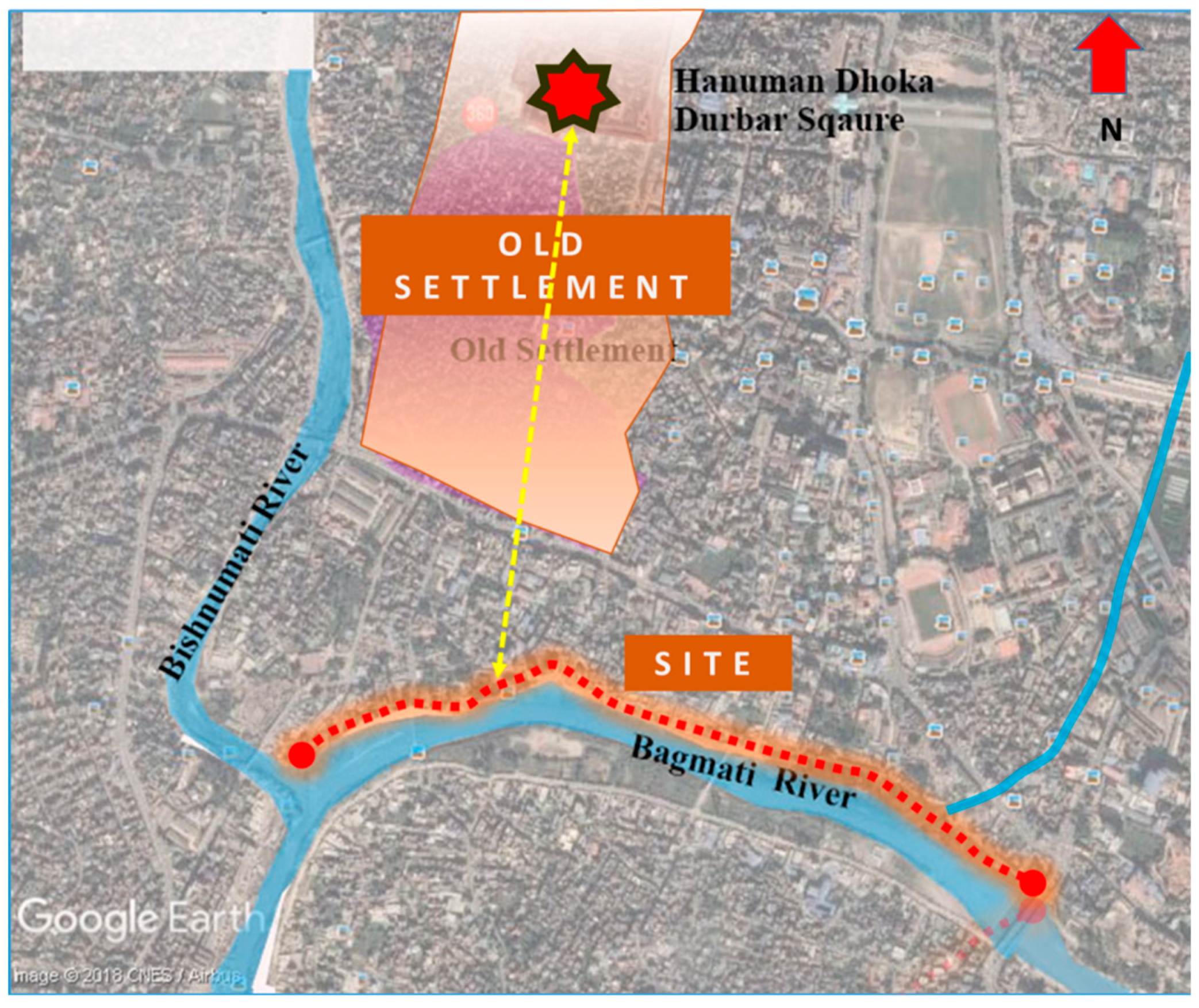
Ghat are located along the 1.5 km stretching from Thapathali to Teku
Dobhan. The location of the site is shown in
Figure 1 with coordinates, while
Figure 2 shows the major monumental structures along the river side with the timeline of its construction. More than 100 historic structures including a three storied tiered temples complex (temple within the courtyards surrounded four sides by
sattals and
Pujari Ghar (house)), the shikhara temples complex (temple within the courtyards surrounded by the
sattals at all four sides), the dome and bell-shaped roof temples complex,
Sattals for hermitage and
Sadhus,
Sattals for people who visit the place for the cremation events of their deceased family member, cremation platforms,
Brahmanaal,
Bhakari, the wall with niche for changing cloths after bath are present. Moreover, this stretch hosts shrines, small temples, chaityas, and a monastery; most of which were constructed in the 19th Century. However, the significance of this stretch dates back to the Lichhavi era (beginning of Christian era to 9th century CE). The confluence of the Bagmati and Bishnumati, and the Pachali Bhairab has been considered by far the greatest from the days of the Lichhavis or the beginning of the Christian era [
2]. Recently, the Department of Archaeology has been working towards the announcement of preserved/protected monument, which would then be preserved by the guide of a preservation act [
3].
Unfortunately, once pristine and established with full glory, this stretch has transformed into the open dumping ground and urban slum. Uncontrolled growth in Kathmandu, lack of proper and appropriate infrastructure for the growing population, this stretch of the River Bagmati once became the landfill site. As a result, the new river bank ended up disintegrating the original river
ghats from the river [
4]. The cremation platforms are slowly turning defunct;
Sattals built especially for the facilitation of performing last rite are occupied by people who migrated to the valley in search of employment. Almost all of the sattals are rented out to generate income; few were sold out, and a lack of periodic maintenance and repair of these structures left them gradually dilapidated. The massive earthquake in April 2015 acted as the catalyst to transfigure these structures which are more vulnerable and risk leading to decay and collapse [
5,
6,
7,
8]. Many are in a ruined condition and still inhabited; few have collapsed, waiting for the restoration and reconstruction, few are reconstructed in reinforced cement concrete. Out of these, two prominent temples are under reconstruction. There were several festivals, campaigns conducted for the conservation of river, water and historicity along the Bagmati in the past and some continue until now but are not in sufficient shape to do so in the right way [
9].
This study focuses on where the conservation lacks from its principles. The state of all major principles of heritage conservation, significance and values, documentation, participation and sharing of heritage are studied [
10]. The study methodology includes literature reviews from the various sources, mainly previous reports related to the site. A site visit was done for the study and documentation was identified on the architectural heritage of the site area and present condition. Interviews have been done with the various stakeholders and locals to understand the site and issues very clearly. Meetings were undertaken with the Department of Archaeology, Guthi Sansthan, Ward office and heritage division of Kathmandu metropolitan office regarding the issues of this area.
2. Historical Background and Significance
The Bagmati, the principal river of Bagmati Basin of Central Nepal, originates from Baghdwar at Shivapuri Hills at an elevation of 2732 m. It flows down to various parts of the valley and finally exits from Katuwal Daha at the elevation of 1140 m. The total catchment area of Bagmati within Kathmandu valley is about 157 km
2, with the length of 44 km in the valley itself. It further flows down to the Terai reason of Nepal and finally to the Gangetic Plain [
11]. The river is characterized as medium and dry basin fed by springs and monsoon rainfall [
12] and a number of tributaries originating at Mahabharat and the Chure Range before it reaches Terai at Karmaiya. Within the valley, Bishnumati, Rudramati, Icchumati, Manohara, Godawari, Kondu, Manamati, Balkhu, Nakkhu meet the Bagmati at various points.
Since the earliest records, the Bagmati and its tributaries have played an important role in the development of the valley. The importance of the Bagmati River has also been mentioned in many ancient religious texts where Bagmati was supposed to be borne out of the laughter of Lord Shiva [
13].
According to a famous legend, King Gunakama Deva established a city on the bank of river Bagmati at the conglomeration of the Bishnumati River in the 10th century CE. The king then installed shrine of
Pancha Lingeshwor Bhairab, which later became popular as
Pachali Bhairab. The oldest evidence is the inscription of
Nepal Sambat 803 (BS 1740, 1683 CE) [
2].
The conglomeration of two sacred rivers, Bagmati and Bishnumati, one of the 12 Tirtha of the valley Chintamani Tirtha (in some text Gyan Tirtha), has been the holiest site for both Buddhists and Hindus since the earliest time recorded. Teku Dobhan Ghat is believed to have the earliest temples built on this sacred site at the time when Ne Muni used to meditate there.
These ghats are built for performing the last rite: the cremation of the people. In earlier days to almost the beginning of the Panchayat system (1958 CE), sick and dying people were brought to the Ghat and stayed in the Sattal with the belief of the water of Bagmati having curative power. Interestingly, some sick people would sometimes be cured and return back to their home. It is the ritual that the deceased, placed over the slope stone platform with the Narayan idol carved on it (called as Brahmanaal) so that the feet of the deceased would touch the river water. The belief behind this is that it would fulfill the last wish of the deceased and allow the spirit to pass out effortlessly. Prior to the cremation, water from the river is poured into the mouth of the deceased and after the cremation, their ashes are washed away into the River. The families take bathe after cremation is over in the river and one who put the funeral lamp be Kriya putri for 13 days. Bhakari, circular shaped stone platforms are also used to do “Shraddha” of deceased every year on the day of death as per lunar calendar.
Another confluence along this stretch from Thapathali to Teku is at Kalmochan
Ghat where Icchumati (commonly known as Tukucha) and Bagmati meet. This
ghat is considered as one of the earliest periods because of the presence of statue of Uma Maheshwor and the Lichhavi Votive
Chaitya. Including these two river
ghats, there are fourteen
ghats along this stretch from Thapathali to Teku which were built at different historical periods. These ghats are Kalmochan
Ghat, Chandra
Ghat, Juddha
Ghat, Aryal
Ghat, Purohit
Ghat, Kali
Ghat, Kaji
Ghat (Bagabhakewor
Ghat), Punya
Ghat, Kaidi
Ghat, Hanuman
Ghat, Pachali
Ghat, Panchanari
Ghat, Munsi
Ghat and Chintamani
Tirtha Ghat. Each
ghat has its own significance as each is for a different caste of people. Moreover, this river bank precinct is adorned with the numerous different types of temples complexes,
sattals,
pati,
Dharamshala,
Akhada and shrines.
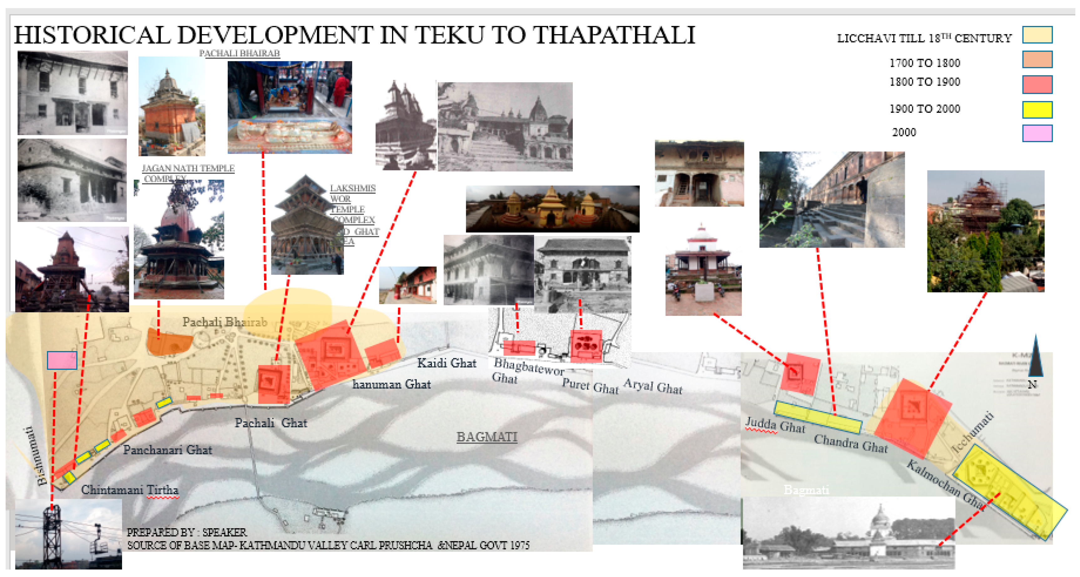
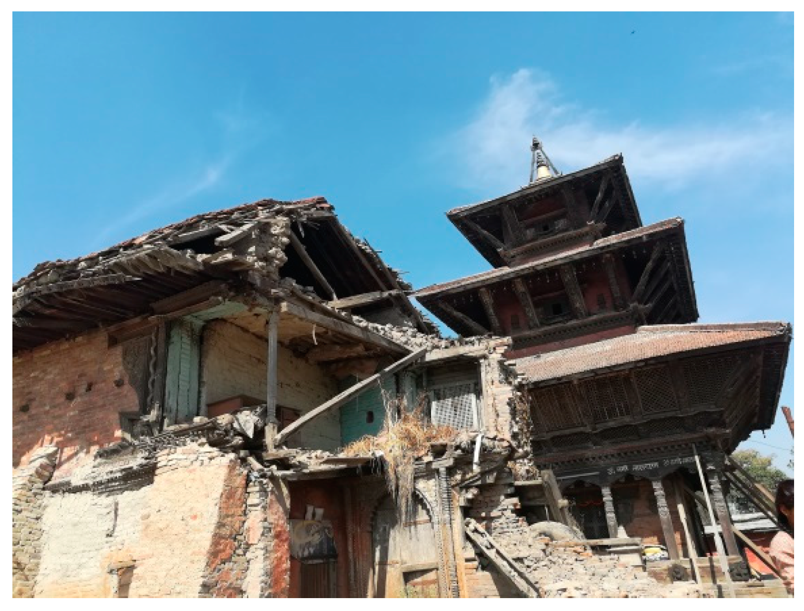
Figure 3 and
Figure 4 show the
akhada near the Thapathali Bridge which provides a residence for
sadhus and the typical
sattal.
Figure 5 and
Figure 6 show the multi-layered temple with damaged
sattal and
Shikhara style temple in the area.
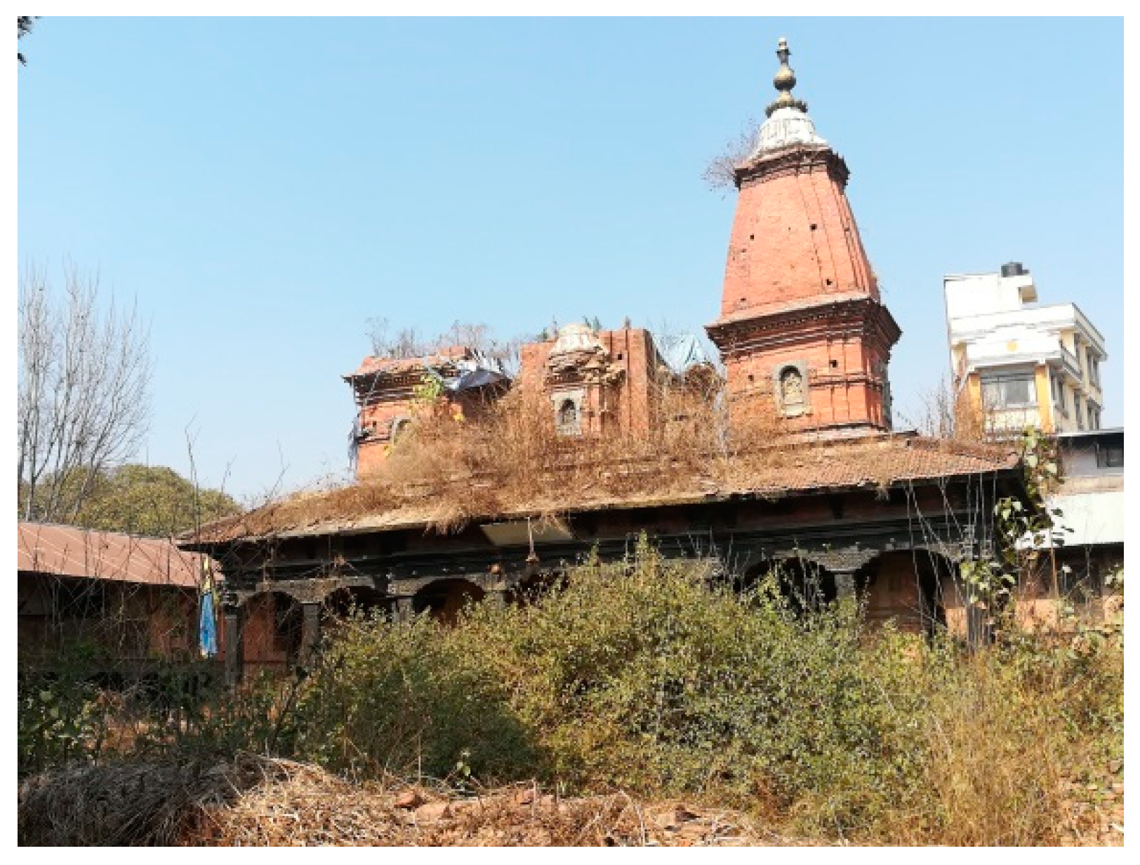
Tripureshwor Mahadev Temple complex, built by Lalita Tripura, Queen of Rana Bahadur Shaha in 1818 CE, and Lakshmishwor Mahadev Temple complex, built by third queen of Rana Bahadur Shan in 1813 CE, are two iconic temple complexes built in the Newari traditional style. Square in the plan, built over the multiple layers of the podium with brick in mud mortar and the wooden posts and joists, beams, elaborately carved windows and doors, located at the center of the courtyard surrounded four sides by the
Chau Ghera Sattals. These temples are an excellent example of Early Shah—19th century heritage built in the traditional Newari Style. The temples are mainly entered via south from the Bagmati side. While undertaking the
Nitya Puja and other
Puja, the water is fetched from the River Bagmati.
Table 1 shows the list of major monumental buildings in the study area with old and recent photographs.
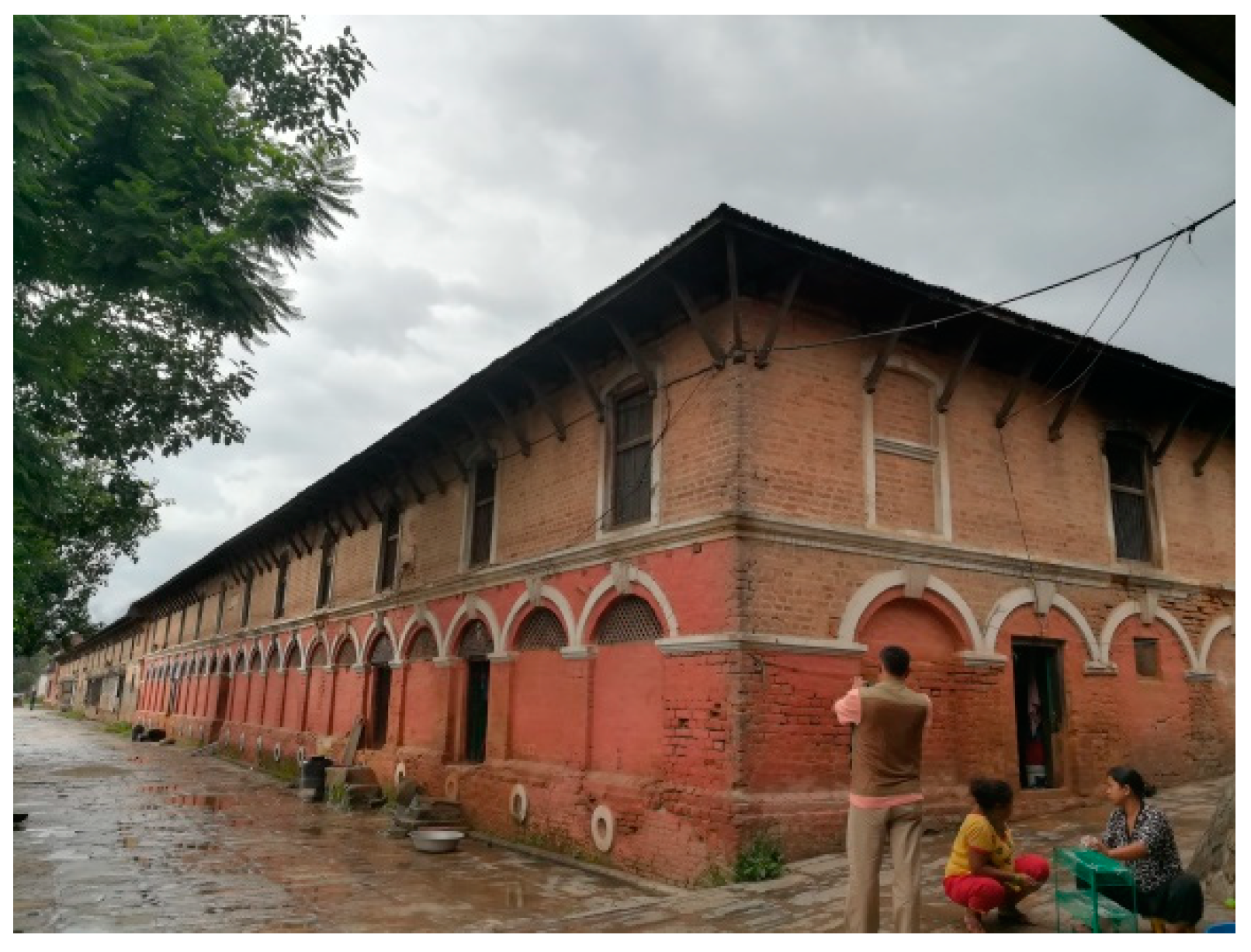
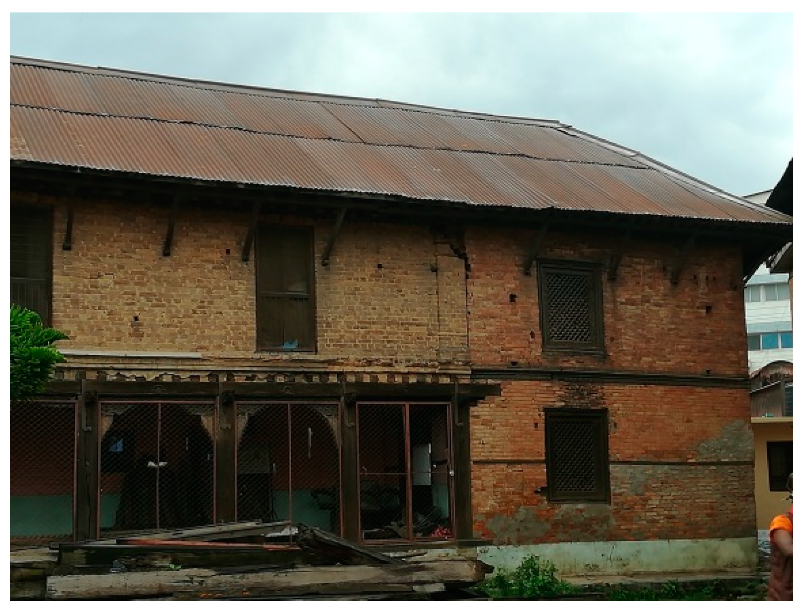
One of the largest temples is Jagannath temple complex built by Bharo Bhava Singh Pradhan in 1792 CE. This temple is built over the octagonal plinth and the plan of the temple is also octagonal. The Shikhara Style temple is built with terracotta in mud mortar with intricately carved windows. Teen Dewal temple complex, also famous as Bambikateshwor temple, was built by the commander-in-chief and acting prime minister Bam Bahadur Kunwar Rana in 1850 CE. Rectangular in plan, built over the multi-layered platform, this temple has three Shikhara styles extended structures, hence named as Teen (three in Nepali Dialect) Dewal. The temple is surrounded four sides by the Sattals. The boundary wall at the south aligning Bagmati River Ghat is provided with niches for changing cloths after the bath. Another monumental temple is Jang Hiranya Hem Narayan Temple, built by Prime Minister Jung Bahadur Rana, which is square in plan with dome shaped roof. While building the temple complexes, Ghat are also built along with them. Other structures in this area are the temples with dome and bell shaped roof and square in plan. There are more than 15 temples of this kind in this precinct. The Sattals are another important components of the precincts, built mostly during Rana Period in neoclassic and Newari style. Sattal, built by then Prime Minster Chandra Samsher Jung Bahadur Rana, is an excellent example of the neoclassic style in this precinct. Puret Ghat Sattal, Mathema Sattal, Manadhar Sattals are also the best examples of the 19th century heritage.
Three Akhada complexes (around the Jang Hiranya Hem Narayana Temple complex) were built by Prime Minister Jung Bahadur Rana for the Sadhus of three sects of Hinduism. These complexes are the hermitage for the Sadhus. During the Shiva Ratri, and these sattals were occupied by the Baba or Sadhus who came to valley for the pilgrimage.
The original use of the Sattal as a temporary shelter for the pilgrims; for those who come for the funeral procession; and for performing rituals during the cremation has been altered in many sattals. Many of them are now used as the rented out for residential purposes: Juddha Sattal has been adapted into the school building, old age home, orphanage, Guthi Sansthan office, Chandra Sattal has been adapted as the barracks of the Nepal Police. In the Udasi Akhada, the Sattal complex was built by Junga Bahadur Rana, Udasi sect was established by Guru Nanak Dev’s Son Shri Chandra. Guru Grantha Saheb is also established in this Akhada, now turned into Guru Nanak Museum.
Pachali Bhairab Jatra, ritual bath on the day of Dashain, ritual bath by the ladies on the Rishi Panchami, Nitya Puja and Puja on the Shiva Ratri; Khata (palanquin) Jatra festival of Pachali Bhairab and Jagannath temple are the festivals observed in this precinct. Hymning of Shiv Bhajan on every Monday and Friday marks this cultural space more spiritual and religious.
Agricultural land in this area used to be mostly owned by the respective temple or Sattal Guthi for the maintenance and repair. However, the establishment of Teku Hospital in 1951 CE and later in 1970 CE expansion, the ropeway linking Terai and valley in 1963 CE, Transport Cooperation in 1964 CE and National Trading Limited in 1967 CE have gradually affected the tranquility and integrity of the site. In the last three decades, this area is highly crowded with ribbon development.
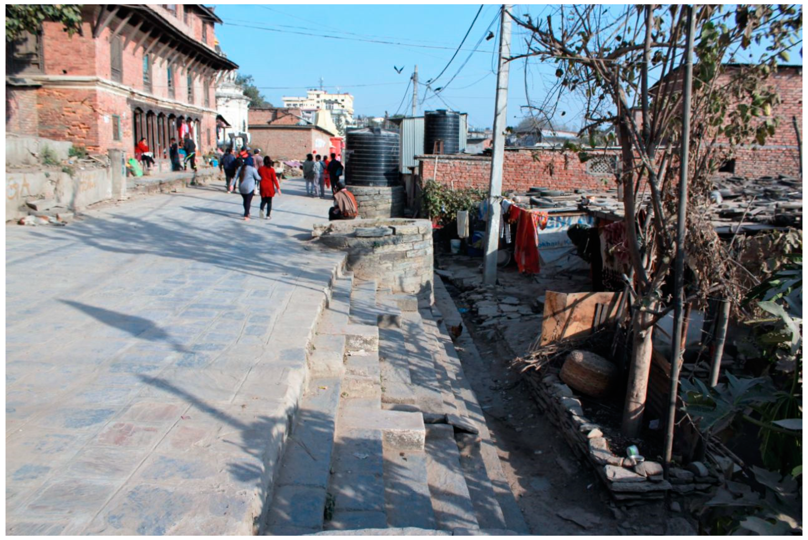
3. Present Condition
Encroachment and disintegration between the river and original cultural river
Ghat by the degraded space have existed for two decades.
Figure 7 shows the encroached area in Puret
ghat area, where the
ghat area is totally occupied by slums. Due to the unmanaged rapid growth and the urban development in Kathmandu, the Bagmati River has been highly polluted due to the encroachment of its bank with the direct disposal of waste and sewage in the river. The process of waste and sewage disposal has led to the
Ghat steps being buried, resulting in the cultural space connecting the river with the people being degraded. The encroachment is at its highest when these dumping site turns into the slum dwellers, which has again affected both the river and temples,
Ghats, and
sattals of the area. None of the stretches from Thapathali to Teku Dobhan have been protected from the encroachments. The Kalmochan area, these lands have been used for washing and daily cleaning chores by the people staying in the
Sattal. The scenario of stretch after crossing the Tukucha stream is similar to the encroachment of dumped land. The open manhole and drains, the construction of the temporary huts, the construction of the wells and water bodies without the consent from the municipal body makes these spaces ugly and leads to the destruction of the natural riverbank environment. Unfortunately, the area along the Puret
Ghat area been more degraded state as most of the
Ghat steps and
Bhakari been buried and the slum has come up. The growth of the slum is increasing day by day. The stretch at the Pachali too has similar stories, with alteration of the original Ghats to new concrete
Ghat steps, the dilapidated condition of the original existing
Ghats. The Teku Dobhan
Ghat stretch is more vulnerable as the
Ghat steps and
Bhakari have been completely covered, and the dumped site has been turned into a modern garden with a tall fenced railing, which not only impacts the cultural space negatively but also makes the space exposed to flooding.
The earthquake in April 2015 impacted the area massively. Almost all of the heritage structures were in dilapidated conditions, some were completely collapsed, some were standing but in a ruined and dilapidated condition. Cracks on the cross wall, and the joint between the cross and longitudinal walls, damage in gable walls, holes on the attic floor are the most common issues. In many of the buildings, especially Sattals, cracks have appeared in between the front longitudinal wall and the floor. Roofs are mostly damaged and water leakages are observed. Vegetation growth and damp wooden joists are common problems observed.
4. State of Conservation Measures
For the conservation, protection, rehabilitation of the Bagmati River Basin, its adjoining
Ghats and the heritage edifices, numerous attempts have been made by various sectors. A few pieces of research have been done for such heritage structures aiming at vulnerability assessment and greater resilience [
17,
18] from an engineering perspective. Along with the national level plans, reports, preparation of the inventories, numerous clean-up campaigns, awareness programs have been executed over the past years.
4.1. Kathmandu Valley Plan
For the overall development of the Kathmandu Valley, then His Majesty’s Government of Nepal has prepared the report and published “Kathmandu Valley Plan” in 1969 [
19]. The first integrated plan formulated, this has come up with one of the objectives as to preserve the historic and present image of the valley and to prepare the land use map and zoning map. This provides the elaboration of
ghats along Bagmati River (Tripureshwor to Teku Dobhan) and the significance of these
ghats in the cultural background (p. 51). The existing land use map shows the site area as the recreational zone (p. 133). The proposed land use map tried to back the region into the Rana Period Development phase (p. 134). This plan seems to have never been implemented.
4.2. Kathmandu Valley: The Preservation of the Physical Environment and Cultural Heritage, a Protective Inventory 1975
A Protective Inventory prepared during 1970 to 1975 [
14] was published by the then Government of Nepal in collaboration with the United Nations, and UNESCO was one of the elaborated and invaluable resources of the cultural heritage of Kathmandu Valley. A comprehensive inventory of more than 800 monuments and the historic settlements recommended the physical development plan for the valley, including the study area. The book has further recommended the designing of the Monument Sites, Monument Zones, Preservation Districts and Natural Preservation District. The book has described the monument zone as a “topographical area which has a concentration of monuments or is important as the connecting setting for individual monuments”.
The book listed the Thapathali Teku river bank temple complexes and the temples as one of the 49 monument zones named as K-MZ2.
Proposed protective measures recommended as it will be necessary to restore the rather dilapidated structures and ghats along the Bagmati River in their total setting, including embankments, paths and plazas as well as the actual monuments together with the attached profane buildings, such as Dharmashalas and patis, and to return then to their traditional uses. Whenever this is no longer possible, new uses related to their setting and environment are to be found. As for the relationship of this strip of river shore to the adjacent hinterland, a greenbelt is recommended surrounding the Monument Zone and protecting it from the service industry-oriented area between the zone and the Kalimati Road city area.
The proposed protection also includes the opposite river shore with the Raj Tirth site and recommends the green belt to guarantee the harmonious vista and frame for the entire area with legal character and a controlling, self-governing body. Unfortunately, the recommendations prescribed in this book were never implemented.
4.3. Kathmandu Nagar Chhetra ka Inventories
The Government has published the inventories of Sattals, Pati, Chaur (open space), Pokhari (ponds) of the Kathmandu. This inventory has listed the Sattals along the Thapathali Teku Bagmati River Ghat in 1982.
4.4. Bagmati Rehabilitation Fund Trust
For the protection and rehabilitation of the Bagmati River, the Bagmati Rehabilitation Fund Trust was established as non-governmental organization (NGO) in 1993. The trust recommended that the zone should be created as the “Riverine Heritage Zone” linking all six major temple sites along the Bagmati River Banks. The overall objectives are to support towards legalization of the river bank demarcations, outlines for the future Riverine Heritage Zone in general, and status in the project area specifically, re-evaluation of all public works, projects planned within the proposed zone, the implementation of channeling and weirs along Bagmati, demarcation of public playgrounds and “urban forests” and rehabilitation of the electric crematorium. The trust supported researching and publishing the book “A Monument Guide—The Bagmati between Thapathali and Teku” [
20].
4.5. Teku Thapathali Research Group
Teku Thapathali Research Group [
21] was established in 1993 to carry out a preliminary research project with the goal of assisting local efforts in a long-term rehabilitation program with in the Teku Thapathali Project Area. This research took the comprehensive assessments and social and physical survey of four main temple complexes. Research recommendations from this group have also the same outcome as the others, as they were never implemented.
4.6. Post-Earthquake Conservation Measures
The Bagmati River Bank Improvement Project (BRBIP) Phase II is an ambitious vision for revitalization of the river corridor of Bagmati River; it involves a number of initiatives working towards improvement of water management and restoration of the health of the Bagmati River. Phase II also focuses on the revitalization of the cultural heritage sites within the river corridor. This includes the following:
Revitalization of Uttar Gaya Temple Area and of Gokarna Temple Area
Revitalization of 1.5 km of river corridor from Guheswori to Tilganga Bridge
Revitalization of 1.5 km of river corridor from Thapathali to Teku on the right bank, including the temples and heritage structures.
Recent work has been done in coordination with governmental organizations, UNESCO and local community with aim to prepare the detailed study report, retrofitting/reconstruction of structures along with management plan and further process for the establishment of Protected Monument Zone.
The restoration of Tripureshwor Mahadev Temple and reconstruction of Jang Hiranya Hem Narayan Temple at Kalmochan are being carried out. Both temples were damaged (the second completely collapsed) due to the massive earthquake in April 2015. Other community and government initiatives continuing in the care of Bagmati River and its banks are as follows:
The Bagmati Heritage Walkway by Kathmandu Metropolitan City
The UN Park Master plan on the bank of Bagmati river
The Bagmati Cleaning Campaigns
Various awareness programs; Save Bagmati Campaigns through exhibitions
Meetings with stakeholders show signs of hope that these dilapidated structures will be restored. A BRBIP initiative with funding support of Asian Development Bank (ADB) provides momentum in restoration of heritage structures; however, the management issues have to be solved for the sustainability of this heritage site.
5. Discussion on Challenges and Issues
This precinct site hosts a number of holy places which connect a diversified community with their culture and heritage. Proper management of the structures, use and periodic maintenance could help to bring back the heritage site to its original condition. Such precious places have to be well maintained, which not only saves the culture and heritage but also attracts tourists. Four of the major specific points found during the study are mentioned here, in heritage conservation management.
5.1. Significance and Recognition
Even though the need for conservation and protection of the site have been recognized in documents since the beginning of the new Government of the Panchayat System (1958–1990 CE) and then series of new democratic governments in Nepal, it is unfortunate that there was lack of recognition of the significance of the site. That adjourned the declaration of site as a Protected Monument Zone which further delayed in proper conservation initiation. Unprotected river ghats have been used as the dumping sites. The area nearby has witnessed uncontrolled ribbon development. A hospital, tall apartment buildings, commercial buildings, private residential dwellings have appeared without any proper planning. Many river ghats have been dumped and some disappeared. With the haphazard development and change in land use in and around the site, a once integrated site is now fragmented. The demarcation of the boundary as the Protected Monument Zone is more challenging in the current scenario.
5.2. Co-ordination between the Stakeholders
Almost all of the edifices, except a few under the Private Guthi, are with the owner ship of Guthi Sansthan. As per the Ancient Monuments and Preservation Act 1956, article 3, Department of Archeology shall conserve the ancient monuments and archeological sites which are important from national and international perspective. The lack of effective coordination observed amongst Guthi Sansthan, Department of Archaeology, municipal wards and community in the site. It has left many properties as unattained or misused by unauthorized persons.
5.3. Material Originality and Authenticity
Under the process of reconstruction and restoration, it is in practice to use lime surkhi mortar, replacing the original mud mortar. The process is replacing traditional skills and material. We should focus on how the authenticity can be protected during reconstruction and restoration.
5.4. Slums
The slum settlement at the river bank enchroaching the historic ghat area is a major issue found to restore the historic precincts. Once the temporary sheds are now then converting into the permanent structures.


