1. Introduction
The purpose of this work is to discuss the rationale and the objectives of the training program of the Architectural Conservation Laboratory, University of West Attica on the conservation of rubble architecture, focusing primarily on the aspects of condition assessment and documentation. The methodology and the preliminary results of the condition survey undertaken at the Bronze Age site of Pseira are reported.
The main scope of the program, besides the training of students and professionals, is the development of protocols for rapid condition assessment and documentation of rubble architecture with the scope of establishing the conservation priorities. Furthermore, the program aspires to create a methodology for systematic monitoring of remote archaeological sites by utilizing user-friendly and cost-effective tools. In the course of the program, an interdisciplinary approach has been adopted which aims at the examination of the physical condition of the ancient fabric; the assessment of the rate of deterioration and the identification of current and potential threats. The data acquired are used to determine the conservation priorities, taking into account the values which are assigned to the site and the vulnerability of the architectural remains.
The program is entitled ‘Conserving Sites at the Islets of Lasithi’ with the acronym CSI-LA and is implemented in collaboration with the Archaeological Ephorate of Lasithi, East Crete and the Institute of Aegean Prehistory (INSTAP)—Study Center for East Crete, with the generous support of the J.M. Kaplan Fund (2015) and the Global Heritage Fund (2016–2018). The fieldwork has so far focused on the Minoan sites of Mochlos and Pseira, which are located on two small islets on the north-east coast of Crete that are currently uninhabited (
Figure 1). In its first four cycles, the program has trained more than 40 people, including postgraduate students and mid-career professionals. Documentation, condition survey, and mapping, have been completed at both sites, the conservation needs have been determined and the final conservation master plans are currently being reviewed and finalized.
2. Conservation of Archaeological Sites: Where Does it Stand?
Amongst the major achievements of the heritage conservation discipline over the last century, was the maturing of its philosophies and principles and the growth of international consensus on the conservation and management of cultural heritage in its entirety. These are reflected in the doctrine documents, which were developed and adopted by several nations and cultures around the world. The principles of minimal intervention and in situ preservation as well as the need for interdisciplinary work and international collaboration were endorsed in the earliest doctrine documents; the renowned Athens (1931) and Venice (1964) Charters. It was gradually acknowledged that excavation is a destructive and irreversible process, which deconstructs the archaeological context and exposes the natural fabric of the sites to inevitable deterioration, which begins upon excavation [
1].
While the acquired data, artifacts, and ecofacts are presented and interpreted in detailed reports, publications, and exhibitions, the presentation of architectural remains requires rather complex, time-consuming, and costly procedures. Conservation and management master plans have to be drafted and implemented on site, through interdisciplinary work and involvement of the key stakeholders [
1,
2]. The decision to conserve and manage an excavated site is subject to a series of considerations, such as the assessment of a wide range and often-conflicting values, its overall state of preservation, as well as issues of future sustainability [
3,
4,
5].
Over the past century, there was a significant movement towards the preservation and management of built heritage; however, efforts and funds were largely devoted to monumental architecture, the value of which is considered self-evident, while vernacular architecture or rural sites, where the assessment of values is often biased, depending on various contextual factors, remained in the shadows [
6]. This is reflected in the aforementioned early doctrine documents (Athens and Venice Charters), which emphasize the historic and aesthetic value and primarily address outstanding/monumental architecture [
7]. Subsequent doctrinal guidelines and charters on cultural heritage preservation focused on the scientific and social values and the importance of the conservation and protection of heritage in its entirety. The European Charter of the Architectural Heritage, adopted by the Council of Europe in 1975, draws attention to vernacular architecture at its very first article, where it proclaims that “The European architectural heritage consists not only of our most important monuments; it also includes the groups of lesser buildings in our old towns and characteristic villages in their natural or manmade settings”. In 1979, the Burra Charter referred to ‘places’ instead of ‘buildings’ or ‘sites’ and considers cultural significance as a major decision-making criterion for the planning of conservation programs [
1,
8].
Since the 90s, the challenging and complex issue of values was extensively addressed in both the conservation and the archaeological literature, proposing methodologies for the identification and assessment of values and promoting value-based approaches in heritage conservation and management [
3,
4,
6].
Carver (1996) extensively discussed the debate on the monumental value versus the archaeological/scientific value of heritage sites [
9]. He argued that cultural heritage sites are valued for their ‘monumental value’ rather than their potential ‘research value’ and pointed out that in many countries legislation favors the concept of monumentality. Carver’s argument extends beyond the known sites and urges the protection of the unexplored archeological resources in favor of future research and acquisition of new knowledge and the adoption of ‘research-friendly’ conservation system.
Today, legislation for the protection of unexplored areas of archaeological interest exists in many countries; however, its enactment is often subject to political agendas. Governments have also introduced legislation that targets the conservation and protection of the sites upon excavation and compels excavators to take on responsibility of conserving and protecting their sites [
10].
In Greece, the most recent revision of the Archaeological Law, in 2002, declares the director of the excavation responsible for the protection of the site, the stabilization and conservation of the finds, in-situ if possible, and the restoration of the architecture when necessary (Law 3028/2002, on the Protection of Antiquities and of the Cultural Heritage as a Whole, Article 36.8). According to the law, excavators are further expected to contribute to the management of the site and its presentation to the public where possible. Excavation permits can be granted for a maximum of five-year programs and excavators are requested to submit detailed reports on the outcome of their research as well as their actions and future plans for the conservation of the site. Permit applications also have to include an analysis of their budget, where sufficient funds should be allocated to excavation, conservation of the site, and publication of both movable and immovable finds.
In recent years, there has been a slow transition in the enactment of this legislation in varying degrees, depending on the determination of the local archaeological services to urge excavators to take action. Meanwhile, the problem of the preservation of built heritage has not yet reached sustainable solutions and the majority of the archaeological sites in the Mediterranean region continue to be threatened by the cumulative effects of weathering. It also appears that internationally acclaimed monuments continue to be favored against sites which lack ‘monumental value’, despite their undeniable archaeological significance and their designation as cultural heritage sites. As a result, many of these sites, which best represent the socio-anthropological dimension of human civilization, are today increasingly threatened with extinction just as many endangered species. Preventive conservation measures, such as complete or partial reburial, are increasingly appreciated and often proposed; however, survey and assessment of the condition of archaeological resources are still not systematically implemented [
11]. Moreover, the documentation of the sites, which were excavated in the early and mid 20th century, is often inadequate, difficult to access or nonexistent; therefore, sites are often being lost even before we record them.
Conservation and management master plans, value-based approaches, and sustainable strategies remain at the level of philosophical discussion or in the best cases are implemented in pilot programs at privileged sites that are identified as landmarks, national symbols or major tourism attractions. In reality, the theories and the scientific advancements of the conservation discipline have merely reached the daily reality of archaeological conservators in Greece and most of the Mediterranean countries.
It is apparent that despite the recognition of the conservation profession by the state and the aforementioned legislation, excavators have rarely felt the need to include professional conservators in the initial phase of the project planning, as recommended in the literature and the doctrinal guidelines [
11]. They rarely recognize the philosophical, scientific, and managerial aspects of conservation and the role of conservators in the decision-making process for the use management of archaeological sites. Archaeological excavations continue to operate, in their great majority, without professional conservators on site and conservation continues to be a post excavation action. Object conservators who may participate in the program are often called on site to offer first aid or to lift delicate objects and to treat fragile architectural features and decorated architectural surfaces such as mosaics or wall paintings.
The conservation of architectural remains is rarely included in the initial budget and the time and funds allowed for the conservation of the excavated architecture are limited; thus, only the most endangered parts of the architecture can be dealt with. The problem is not new, nor specific to Greece or to the Mediterranean region. The absence of professional conservators from archaeological programs and the disregard of the conservation discipline has been a long-standing issue that is often discussed in the literature. Amongst other scholars, Matero [
1,
12] has stressed archaeology’s neglect of the long history of conservation theory and practice and the absence of conservators from the discourse on the meaning, use and ownership of heritage.
Commonly, architecture that lacks monumental characteristics, such as the rubble structures, are entrusted in the hands of workmen, with some experience in construction or the conservation of historic/traditional buildings, who are usually not familiar with the principles and the methods of archaeological conservation, or the properties of the materials under treatment. Seasonal conservation may take place in the following years, but is almost never based on the assessment of the overall condition of the site, nor is it incorporated in a master conservation that aims at the long-term preservation of the site.
3. Condition Surveys and Documentation
The necessity for the systematic survey, documentation, and monitoring of the architectural remains derives from the need of conservation professionals to understand the weathering phenomena, to trace the evolution of change, to estimate the rate of deterioration, and to identify the factors which affect it. Agnew [
13] discusses the holistic perspective of archaeological site preservation and stresses the importance of surveys and inventories of cultural resources as a first step towards a holistic approach. He suggests that in order to be effective in preserving our heritage, we first need to know and understand the extent of the resources as well as the threats, their effects, and the rate of deterioration of the sites; in other words, how quickly or slowly the sites are being damaged or lost. The examination and systematic recording of the latter comprises the ‘documentation’ an essential tool for the preservation of a site, which as Matero states is the ‘
cornerstone of conservation practice’ [
14].
Documentation can be perceived as means of preservation by itself; while the physical conservation of cultural assets is a time-consuming and complex procedure, detailed and accurate documentation can be employed as an alternative to mitigate against the compete loss of heritage resources. Natural disasters and extreme environmental conditions are occurring at an alarming rate, while humans create their own disasters such as war fair, pressure of development, and overexploitation of resources. Heritage professionals struggle to preserve as much as possible; however, it is unlikely they are able to save everything. Our mission is to slow down the rate of loss through preventive measures, wise use, appropriate interventions, monitoring, and management. In order to do so, we first need to understand the needs of cultural resources and to prioritize our efforts towards the protection of the most endangered sites, taking into account their significance as perceived today by the various groups of stakeholders, with emphasis to the local communities. While the task of the physical preservation of all excavated sites does not seem to be a realistic task, one of the options available to conservators, heritage managers, and decision makers is to document the heritage sites before they are lost. The degree to which the losses of architectural remains can be recovered depends on the consistency and accuracy of documentation.
Documentation embraces bibliographic and archival research, the application of nondestructive diagnostic techniques on site, laboratory analyses, and testing of materials and all the studies undertaken in order to understand the physical properties of the sites’ constituent materials, the deterioration factors and processes in play and the state of preservation of the site in its entirety. It includes annual condition surveys, which provide a systematic record of the evolution of decay over time, as well as vulnerability and risk assessment studies, which allow us to better understand the treats and the risks and to identify the urgent conservation priorities on site.
Conservators aspire the development of digital tools, which will be user-friendly, fast, low-cost, will not require specific knowledge and intensive training, and which will support the conservation process during all its phases. Ideally, such a tool should allow the accurate documentation of the condition of a site or a monument, including all its features and components, the history of past interventions, and the record of current treatment. It should be able to hold plans and high-resolution images bound with spatial data, and any information that derives from visual examination or laboratory analyses. Therefore, conservators seek an integrated tool, which will allow them to evaluate the condition and vulnerability of sites, to prioritize the conservation tasks, to plan the conservation program, to estimate the cost of it, to document its implementation and to monitor the site after treatment. It should also facilitate the dissemination of information, the communication between the conservation team and the stakeholders, and the transfer of the acquired knowledge and experience to future generations. Finally, the identification and assessment of the major risk factors need to be added to the attributes of our documentation tool in order to facilitate effective risk mitigation strategies.
Digital tools are commonly used in conservation to map the condition of sites and monuments in 2D. Illustration programs are considered standard in 2D documentation, while in recent years GIS programs are being increasingly incorporated in land surveys and in the documentation of the archaeological context and its surroundings, but are not yet widely utilized in the conservation and the postconservation condition monitoring of the sites. A relatively large number of 3D applications, usually airborne and terrestrial LASER scanning and photogrammetric methods have also been recently used in the field of cultural heritage, mostly oriented towards visual reconstructions and augmented reality. There are only a few cases where combined 2D and 3D applications are employed in conservation programs for condition surveys and assessment of archaeological sites in the Mediterranean region [
15,
16]. However, over the last few years, 3D documentation methods are being rapidly introduced in the routine of archaeological excavations and provide information, which can be used for the development of conservation master plans and can provide a base for the systematic monitoring of the sites [
17].
4. Background and Rationale of the CSI-LA Training Program on East Crete
The expansion of archaeological research and the increase of the corpus of archaeological sites at the provinces of Greece are linked to the socio-anthropological orientation of archaeology and the increasing interest in the investigation of habitation patterns, tracing movement and exchange of population. Archaeological research reached to numerous sites across the Greek countryside and often to the most isolated and remote areas on the mainland and the islands of Greece. By the end of the 20th century, a dense network of archaeological sites was excavated, most of which were poorly consolidated or not conserved at all and were thereafter left unprotected, and often neglected and forgotten.
Over the last decades, we have witnessed the severe degradation of these sites, which are comprised mostly of subtle, and quite vulnerable, rubble architecture. Amongst them are the Bronze Age settlements of Crete, which constitute the history of the Minoan Civilization. Several Minoan sites were excavated in the first decade of the 20th century and were then abandoned, without any provision for their protection, until the end of the century when many of these sites were revisited with new research questions and new methodological approaches. The majority of these sites today suffer severe deterioration that is attributed primarily to natural and human factors. Exposure to natural elements, lack of conservation and protection measures, mismanagement, and neglect are the main factors which have led to irreversible damage or complete loss of those small sites, which comprise the archaeological landscape and demonstrate the evolution of human civilization beyond the urban centers and the monumental architecture of the ruling elite.
The CSI-LA Program aims to raise awareness amongst archaeologists who work in the Aegean and to provide a methodology for the systematic documentation and monitoring of those sites through the examination and documentation of two Minoan sites on the north cost of East Crete, which exhibit architectural remains excavated in two different periods, in the beginning and the end of the 20th century.
The training program is running on an annual basis since 2015 and addresses the most pressing issue for the conservation of prehistoric sites in the Aegean: the need to rethink the planning, organization, training, and application of preservation practices. It takes place in two remote Minoan settlements located on small islands along the north coast of East Crete and provides on-the-job training opportunities to conservation students, archaeologists, engineers, and early and mid-career conservators to undertake systematic condition surveys and vulnerability assessment studies for archaeological sites; to test and evaluate traditional versus digital methodologies of documentation; and to apply and test selected materials and methods for the conservation of the architectural remains. The trainees are confronted with the problems of the real and challenging issues of site conservation. Their major task is to survey and document the condition of the architectural remains, to identify the major weathering factors, to establish the urgent conservation priorities of individual structures within the sites and finally to use this information for the development of a conservation master plan.
The first training course was implemented at the Minoan site of Mochlos, addressing both theoretical and practical aspects of site conservation. It was funded by the generous grant of the J. M. Kaplan Fund and was the offshoot of the two-year program (2014–2015) of the INSTAP Study Center for East Crete entitled ‘New paradigm for the documentation and conservation of rubble/earth architecture in prehistoric sites in Greece’, also funded by the J. M. Kaplan Fund. The program targeted the major problem in current conservation strategies for prehistoric architectural remains in the Aegean that is the absence of ‘Conservation Master Plans’ for the ongoing and past excavations. A review of the current conservation practices of Greek and foreign archaeological missions has shown that site conservation involves annual wall conservation at sites where excavation has been completed or preventive measures at ongoing excavations, in the best cases. In all cases, there is an expectation that site conservation will go on for many years; however, the goals of this work and its completion are not concepts that are well understood by the archaeological community.
Therefore, the key to the program was to build a new paradigm for the conservation of prehistoric rubble and earthen architecture, which involves systematic documentation, monitoring and the preparation and execution of a conservation master plans, including postconservation monitoring and maintenance programs. The program further intended to serve as a model for other sites in Greece, to begin assessing the rates of various stresses to the antiquities and to provide the empirical data needed to measure the scale and pace of work required for remedial and preventive conservation measures. This blueprint begins with extensive documentation of existing architecture in photos and drawings and a condition report including the pathology, past conservation treatments, as well as current and future priorities for preservation.
During the first year, members of the scientific team of the Architectural Conservation Laboratory of the University of West Attica (Technological Educational Institute of Athens at the time), the Institute of Aegean Prehistory for East Crete and the Hellenic Ministry of Culture together with ten mid-career professional conservators from various archaeological services of Greece participated in the training program. They examined and discussed conservation issues on site through an interdisciplinary dialogue with the archaeologists, conservators, engineers, and technicians who are involved in the program. The condition and vulnerability maps that were produced at the site of Mochlos in the framework of the two-year INSTAP-Kaplan program were updated and the conservation plan was adjusted in order to include new observations and priorities identified on site.
The following training courses (2016–2018) utilized the tools and the methodology that were developed at Mochlos in 2015, in a second survey at the Minoan site of Pseira, aiming to validate and improve the methodology, and to work towards the development of a conservation master plan for the site.
5. The Project’s Target Sites
The archaeological sites of Mochlos and Pseira are located on the north coast of East Crete, on two small rocky islets. Both sites were excavated in the first decade of the 20th Century by the American Archaeologist Richard Seager and were revisited in the late 80s by American archaeological missions.
The first islet is located only a few hundred meters away from the coast of the modern village of Mochlos. The settlement dates from the Early Bronze I period, (ca3100 BC), to the Hellenistic Age, (1st century BC). Recent excavations, (1989–2012), have revealed well-stratified remains for each of these periods.
There is evidence that the area was first settled in the Final Neolithic-Early Minoan I period. The settlement expanded and flourished in the following periods probably due to an influx of settlers from central Crete. The islet was connected to the land though a narrow isthmus which is still clearly visible in aerial images. The harbors situated on either side of the isthmus, joining Mochlos to the mainland and the large coastal plain, that would have been suitable for agriculture, were probably the main advantages for the new settlers. It seems certain that Mochlos had become the focus for new industries including the manufacture of gold jewelry, stone vases, and faience. The presence of workshops which make use of raw materials such as gold, implies that trading relations beyond the island of Crete were already in place from the Early Minoan period. The settlement continued to flourish until the Late Minoan IB period when it was destroyed by fire and although the cause is not known, Seager suggested that the presence of human bones in the destruction levels points out a violent attack rather than an earthquake as being responsible for its destruction. The main remains to be seen on the island today date from the LM I town (
Figure 2) [
18,
19,
20].
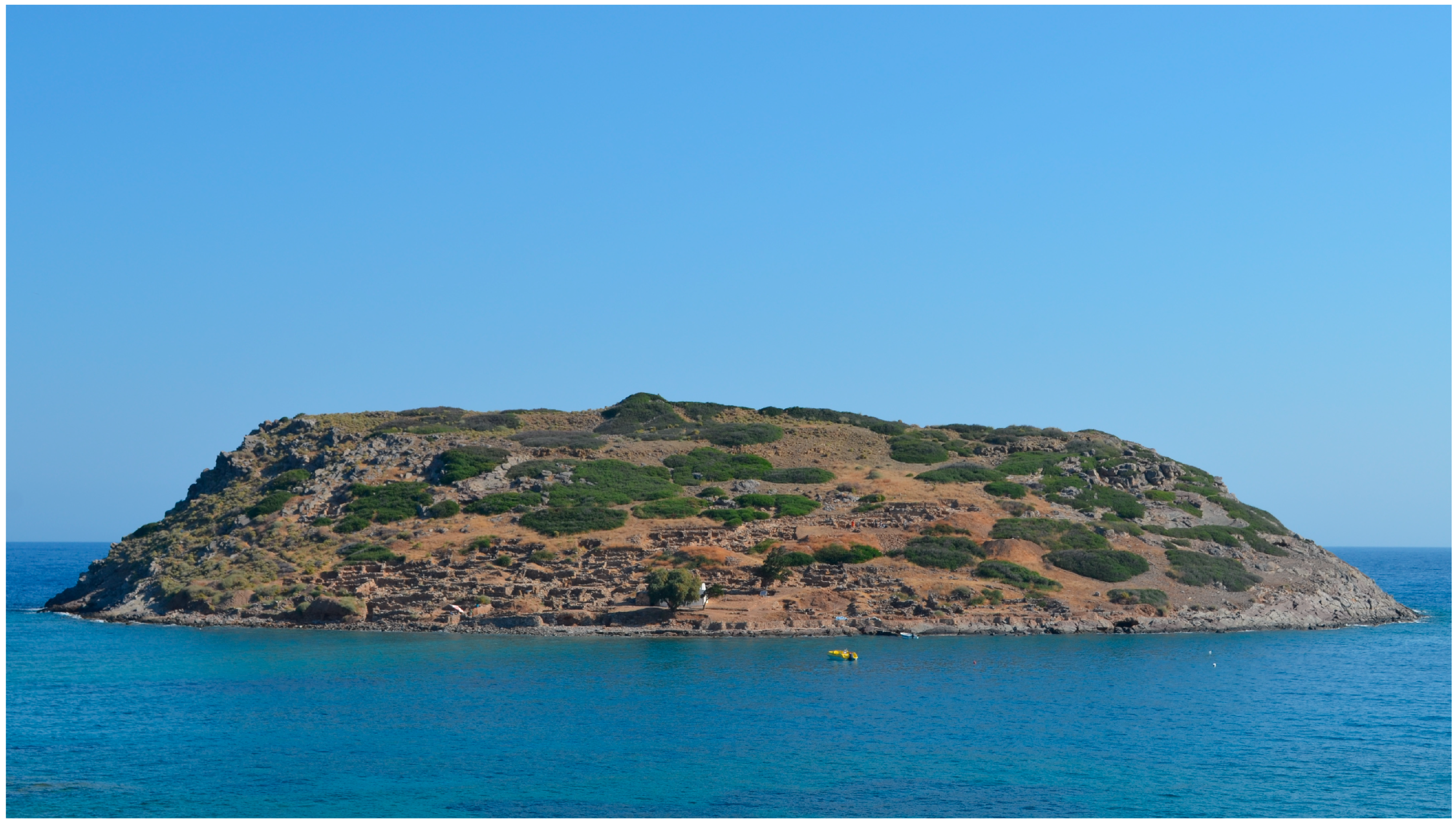
The second site under study is located on the islet Pseira, a couple of kilometers off the North coast of East Crete. The earliest human presence on the islet dates back to as early as the third millennium BCE and as a settlement reached its peak during the Late Minoan IB period (Neopalatial Period of Minoan Crete). Archaeological remains in this seaport are located above its natural harbor, to which it was connected by cliffside stairs. During the Neopalatial Period of Minoan Crete, a prosperous town of some 60 buildings was arranged around it’s the open square (plateia), with a single large building that occupied one side. Like many contemporary Late Minoan IB sites, it was destroyed, ca. 1550–1450 BC. Some of its population cleared spaces in the rubble and for a time continued to dwell in the ruined town. The site was again used in the Byzantine Period as attested by the remains of a monastic complex of the 9th century, built above the Minoan ruins (
Figure 3) [
21,
22].
Large parts of these sites have been exposed to a quite aggressive marine environment for over a century (110 years approx.), while others have been exposed for 20–30 years. Significant losses can be traced at both sites and the rate of deterioration is being assessed though comparative study of archival or published images from the excavation campaigns. Archival research is currently in progress and has pointed out that, in both cases under study, with few exceptions, the existing documentation of architecture does not provide adequate information for the recovery of damage or loss, nor facilitates the identification, assessment, and understanding of the changes which have occurred over time. We have come to realize that in the case of a major natural disaster, such as an earthquake, which may cause the collapse of vulnerable structures, we would not be able to conduct a recovery program, as the existing images do not allow stone-by-stone identification. It was therefore established that systematic and detailed documentation that can serve the purposes of conservation was an urgent need for both sites.
6. Condition Survey and Documentation: Tools and Methodology
Nowadays, sustainability has become an important concept that affects, and to a certain extent governs, our perceptions and interactions with the world. While the word “
sustainability” has mainly been connoted with our concerns and relationship with the environment, it also raises questions on how we undertake research and how we manage cultural heritage resources [
23,
24].
The rapid technological improvements in imaging technology and computer processing capabilities have led to an ever-increasing interest on the application of digital documentation techniques in cultural heritage. This interest has mainly been the result of the many advantages of digital survey and analytical techniques that provide cost-effective, rapid, and reliable data, both in documentation and noninvasive analysis. In this view, the promising correlation between more sustainable cultural heritage practices and digital documentation techniques is a promising area of investigation.
Digital documentation has become the norm in cultural heritage practices [
22,
25,
26,
27]. The recording of the physical features of archaeological remains and structures as well as historic landscapes constitute an important stage in their overall conservation [
25], since virtual records can potentially affect future decision-making processes and may end up being the primary data sources should the artifacts, structures, or landscapes undergo degradation or destruction. Therefore, depending on the conservation needs of a given cultural heritage entity, the researchers utilize data collection techniques such as aerial surveys, unmanned aerial vehicle (UAV) surveys, geophysics, marine surveys, laser scanning, and close-range photogrammetry.
In the case of architectural structures and archaeological sites in general, close range photogrammetry and laser scanners offer great potentialities for the accurate and metric recording of buildings and sites [
23,
27]. However, at a time when the mass digitization of cultural heritage is taking place, interpretation and actual use of the created datasets have arisen as two areas that must be considered. In other words, while the photogrammetric reconstructions have a certain “eye-candy” effect, their actual integration within conservation practices, especially during documentation and monitoring processes is a crucial point that the research team pondered upon.
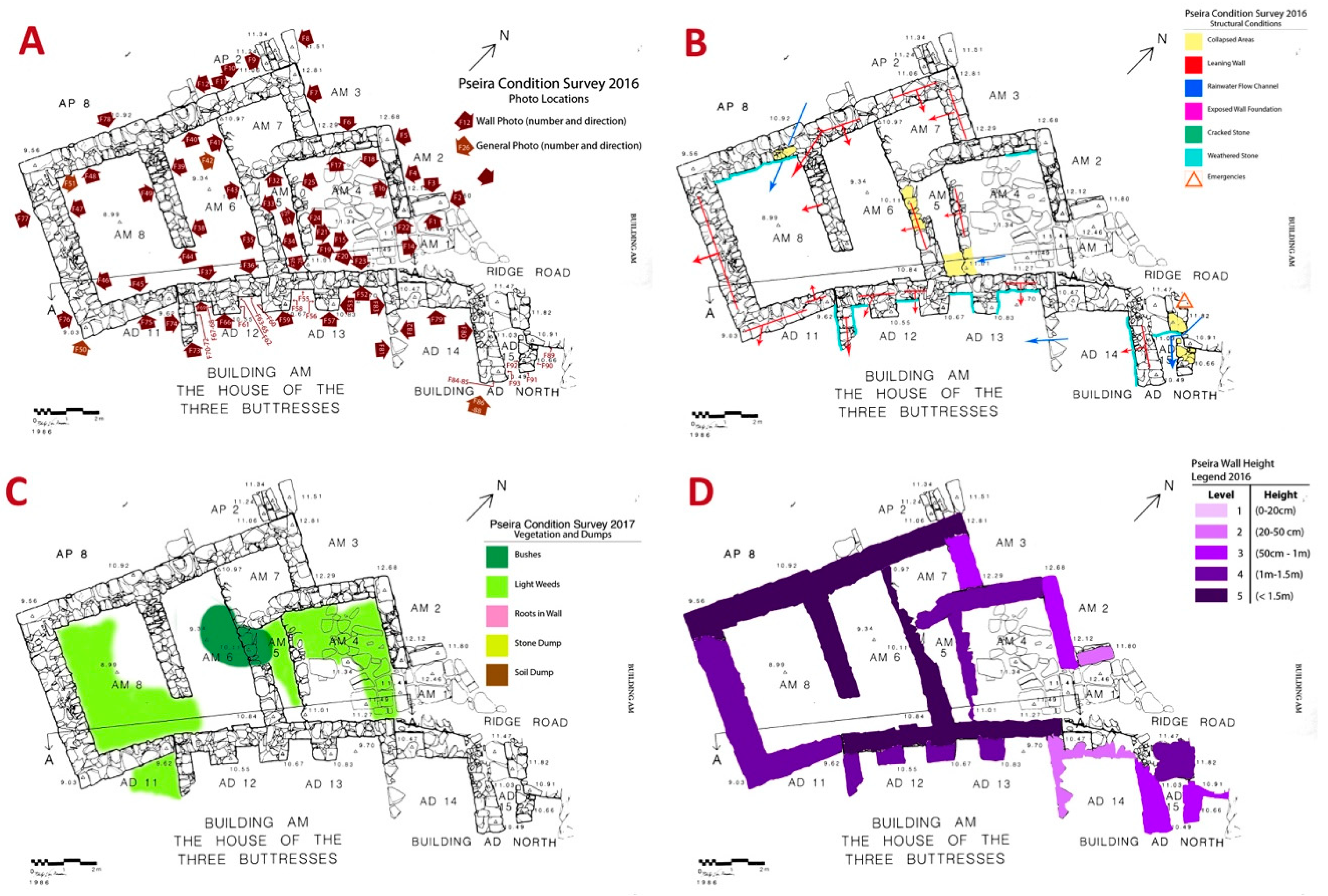
In the case of the training program organised by the Architectural Conservation Laboratory of University of West Attica, the survey of both sites was initially carried out using the traditional tools, which are easily available to conservators, namely plans, digital cameras, pencils, and illustration software (
Figure 4).
A first screening of the whole site was undertaken in order to identify the types of weathering, which are occur on site and to define the evaluation criteria for the condition survey. A weathering glossary was prepared, which included all the types of weathering that can be identified on site by visual inspection, and was used as a manual to guide the trainees during the survey. It included terms, descriptions and photographs of characteristic examples of all wreathing types, as well as a color code or sign, and a numerical weighting factor assigned to each type of weathering, ranging from 1 to 5 numerical points.
The data were recorded in stone-by-stone state plans by means of color coding and mapping. The base plans used for the mapping were provided by the directors of the excavation campaigns that were undertaken in the late 20th century and include the majority of the buildings that were excavated in the first decade of the 20th century.
Photographic documentation (
Figure 4A): detailed photographic documentation was undertaken which included images of all the built structures, captured from all sides with a scale (top and side views). Extra images were captured when necessary, in order to document specific features of the construction materials and techniques or weathering details. The photographic records were registered in the plans, indicating the number of the photo and the direction of image capture. All photos were renamed and archived in drives, while contact sheets were printed and included in the hard copy folders.
Condition map (
Figure 4B): the major types of weathering were mapped on the plan of each building using the designated color-coding.
Vegetation and Dumps (
Figure 4C): the vegetation and the dumps were recorded in the same map, as the growth of bushes is associated with excavation spoil. Different colors were used to distinguish between the weeds, with shallow and less intrusive rooting and the bushes, which present a serious threat and need to be monitored and controlled. Two different colors were also used to distinguish between soil and rock dumps.
Preserved height of walls (
Figure 4D): this information was mapped for first time in Pseira in 2016, in order to trace possible trends in the varying degrees of preservation and to investigate possible correlations between the degree of preservation, the specific characteristics of the walls (i.e., building materials and techniques used) and the environmental conditions that are prevailing in different localities at the site (i.e., costal zone versus the hilltop, north versus the south slope etc.). This data is being currently processed and is expected to provide insights on the effects of the various weathering factors on rate of damage or loss.
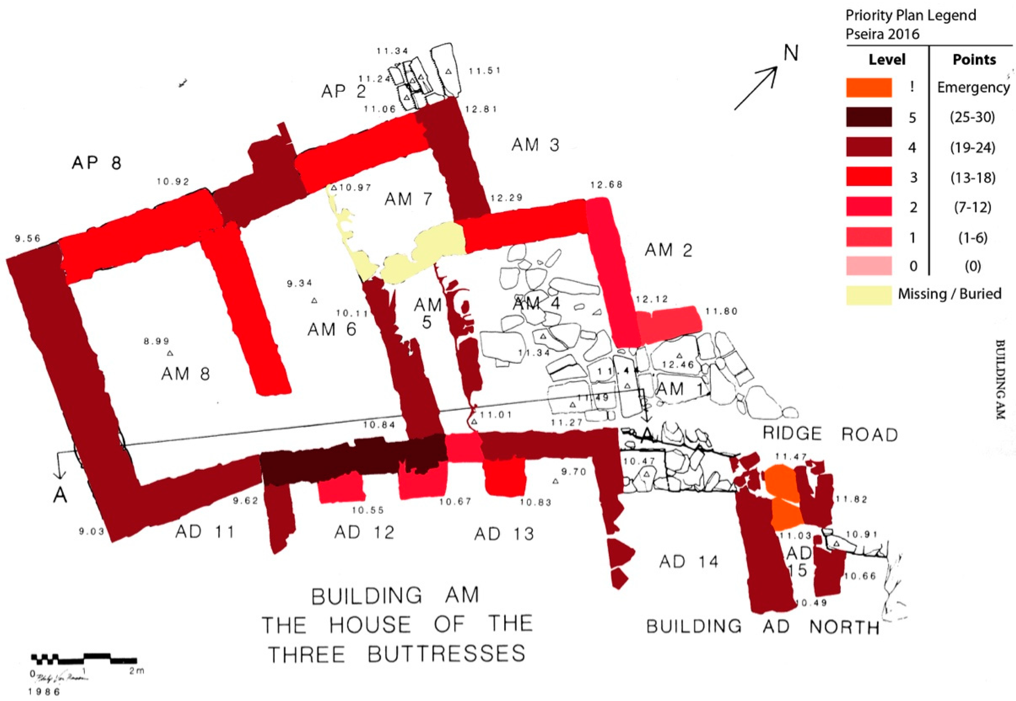
Priority Plan (
Figure 5): the priorities were established on the basis of the vulnerability assessment of each structure and thereafter, of the site as a whole. Vulnerability was calculated by adding the weighting factors (numerical point system) that were assigned to the weathering types identified in each structure (i.e., on each wall, staircase, bench, etc.). Seven levels of priority were established according to the total score of vulnerability. The highest level of priority included the structures, which scored more than 30 points and were marked as emergencies. The lowest level of priority, (level 0), included structures that did not score any points (score=0), which means that none of the types of weathering, that are included in the glossary, were identified. In addition, structures that were illustrated in the state plans but were missing or were buried were marked in the plans without numerical weighting factor. Finally, the archaeological significance of the buildings or specific structures/features within the sites, were also taken into account after consultation with the excavators and the relevant publications. The significance of individual features was added as an extra weighting factor (5 extra points) to the grade of vulnerability. Therefore, features such as the Grand Staircase and the pier-and-door partition (polythiron) of Pseira, or complete buildings such as the shrine of Pseira, were included in the highest priorities due to their archaeological significance although their vulnerability was not at the highest level.
The processing of the data that was acquired from the Minoan settlement of Pseira is still in progress, while at Mochlos, most of the emergencies have already been dealt with during the conservation campaigns of 2015 and 2016. Reassessment of the sites in the following years is considered essential in order to verify the data that were recorded by the trainees and to evaluate the methodology employed. Although the conclusive results of the surveys are not yet finalized for publication, a brief account of the major preservation issues, occurring in both old and new excavations, can be summarized as follows:
- -
Loss of binder in wall masonries and subsequent collapse (complete or partial)
- -
Deterioration of building stone (especially phyllites and metacarbonate at Pseira)
- -
Intrusion of roots into the walls
- -
Washing off / Deterioration of wall foundation, especially at hilltop sites or where excavation extends to earlier occupation phases below the foundation of the walls
- -
Leaning walls
- -
Dislocation of floor slabs, thresholds and other low structures (either by visitors or water flows)
- -
Damages caused by uncontrolled visitation/paths running over low walls
The primary factors, which affect the condition of the sites the following:
- -
Direct exposure to the marine environment: waves reaching the lower parts of the sites and see spray allover the sites
- -
Rain water
- -
Vegetation
- -
Mechanical pressure imposed by excavation dumps deposited over unexcavated areas or next to the excavation trenches
- -
Uncontrolled visitation
- -
Lack of adequate funds for conservation
- -
Inappropriate conservation materials and methods
- -
Lack of post-treatment monitoring and maintenance plan
At the next phase of the program, in addition to the usual 2D mapping and photographic documentation, image-based 3D modeling of the entire archaeological sites and selected individual buildings was carried out. Photogrammetric techniques were tested on site in 2016 as means of digital preservation and monitoring. During the last season we introduced GIS to our program and worked towards the integration of image-based 3D models into the documentation system in order to meet the needs of remote examination and further manipulation of our data.
The potentialities of using photogrammetry in combination with the previously mentioned traditional survey techniques have been tested on two occasions, namely, during the 2016 and 2017 campaigns. The main goals behind the photogrammetric recording was the: (a) documentation, (b) periodic monitoring (c) ex-situ access to the data and, (d) dissemination at the academic and public levels.
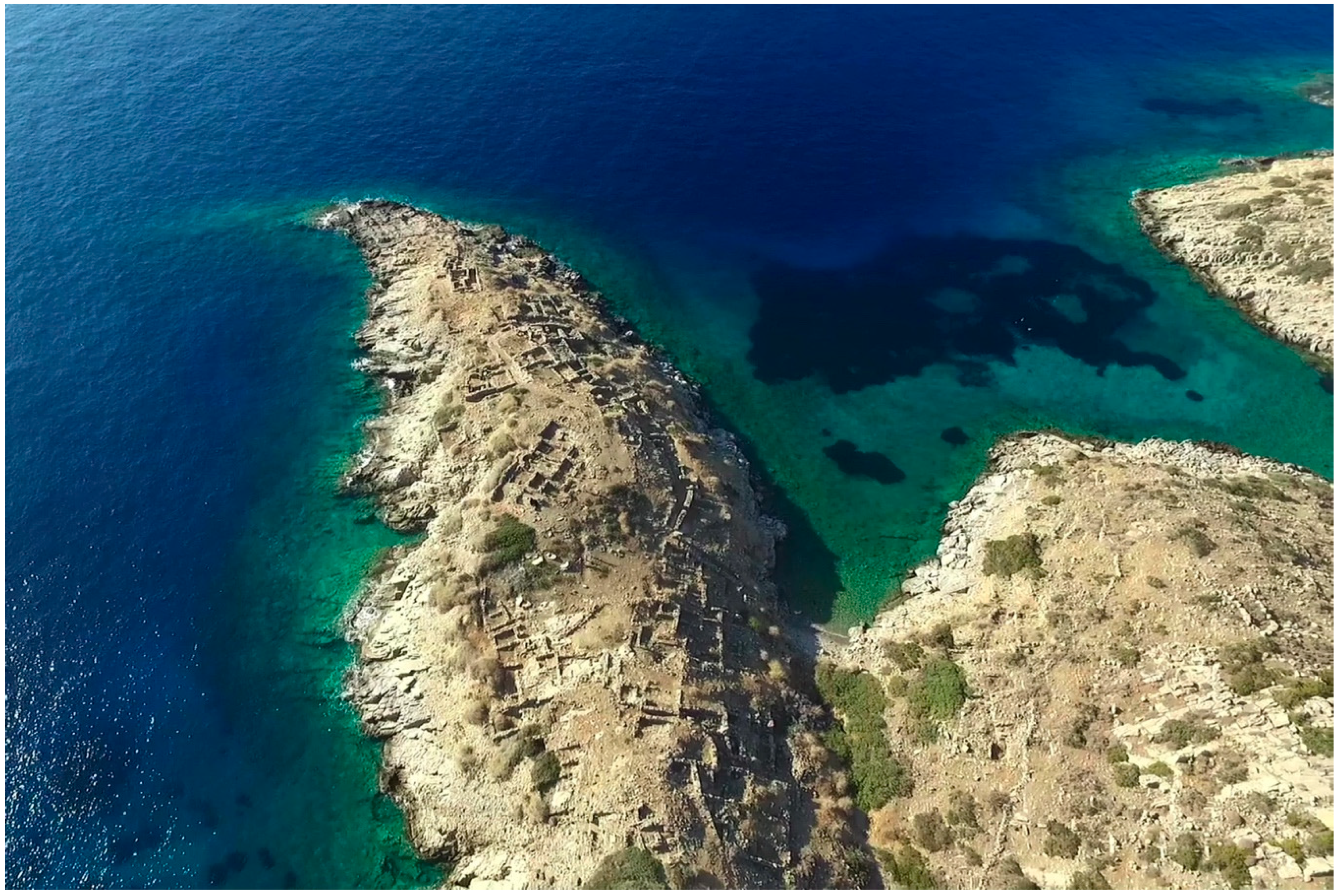
In this quest, aerial images of the entire site of Pseira were acquired through a DJI Phantom drone equipped with a 1/2.3 CMOS 12 Mpx digital camera using video and image capture modes (4000 × 3000 px size images were acquired with F/2.8, ISO: 100 and shutter speed 1/1250). Furthermore, digital single lens reflex cameras were used to photograph building and architectural elements both at Pseira and Mochlos. The rubrics of model reconstruction involved the data acquisition, i.e., photographing (following the rules of the structure from motion technique), a minimal possible preprocessing of the images to preserve original image properties, model building process and, finally the postprocessing of the model. Model building phase of the work was carried out using Agisoft Photoscan. In this initial phase of the photogrammetric documentation, the digital images acquired with the drone camera and DSLR cameras have allowed a successful 3D reconstruction of the sites and archaeological remains. On the other hand, for the purposes of acquiring metric data from these models and their georeferencing, further work is planned during the upcoming campaigns. In this process, the future models will be created with metadata containing “Ground Sampling Distance (GSD) and GIS registration.
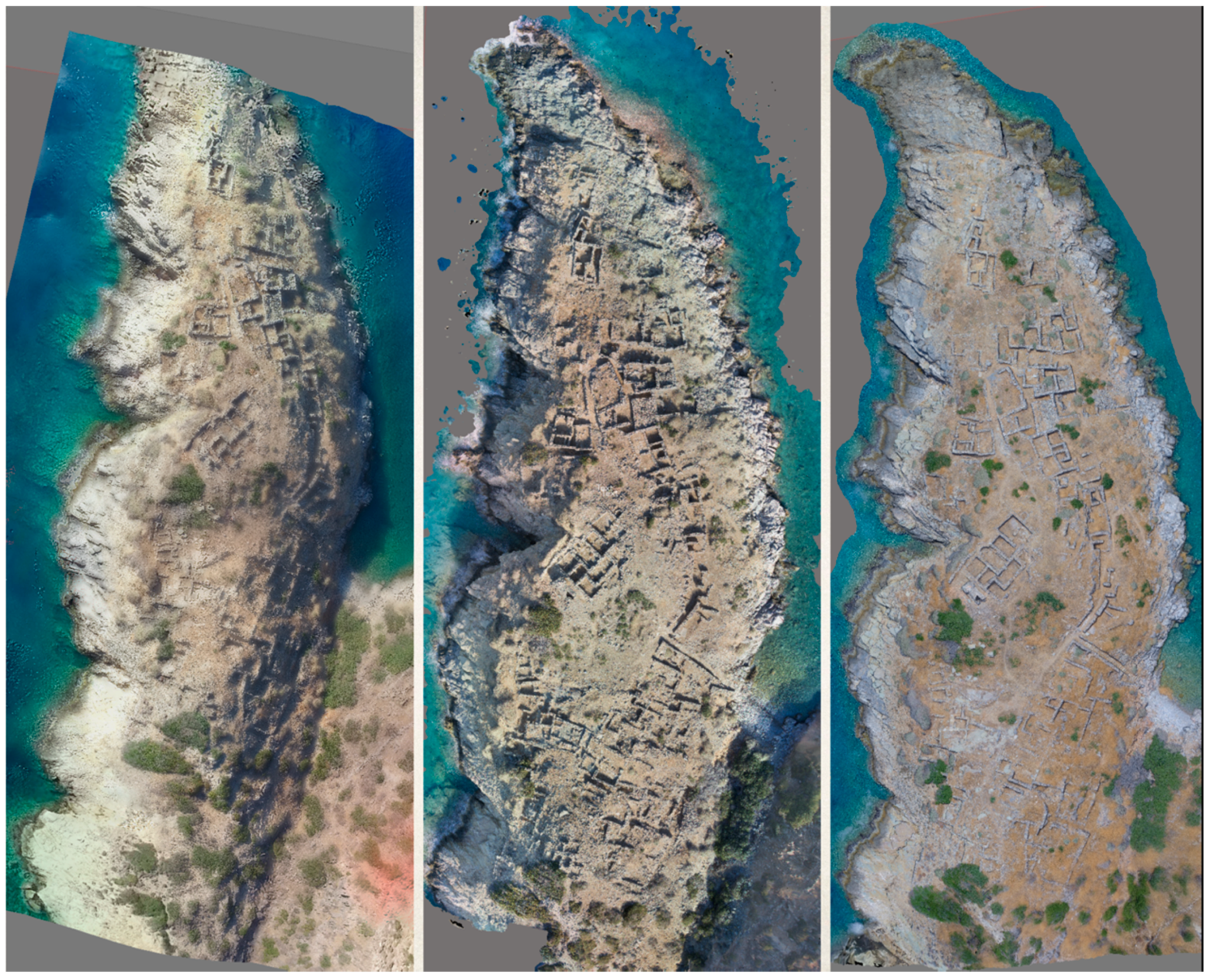
The photogrammetric survey of the Pseira and Mochlos sites was undertaken at three different levels: The first level targeted the capture of the widest area possible, focusing on the entirety of the peninsula where the majority of architectural structures of Pseira are currently visible (
Figure 6). At the second level, the participants of the training program worked on the capture of individual buildings that were surveyed (
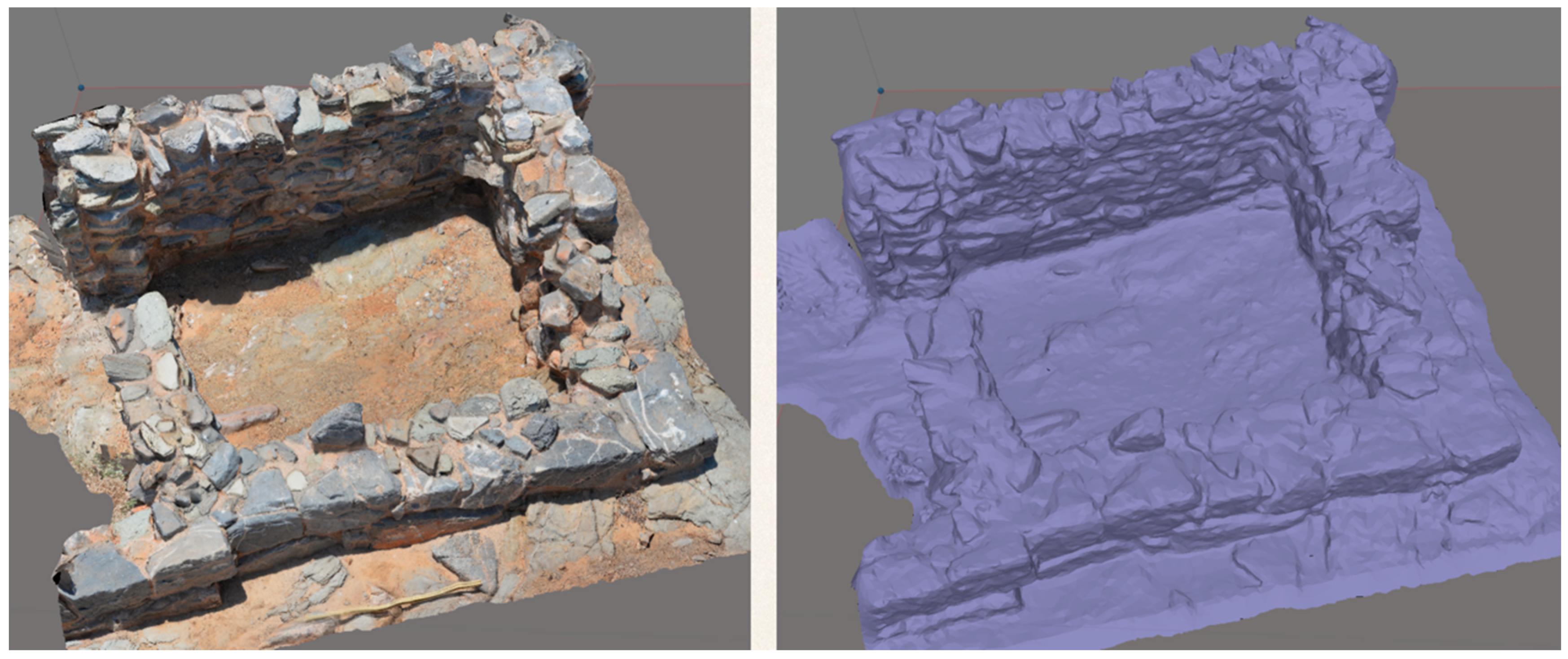
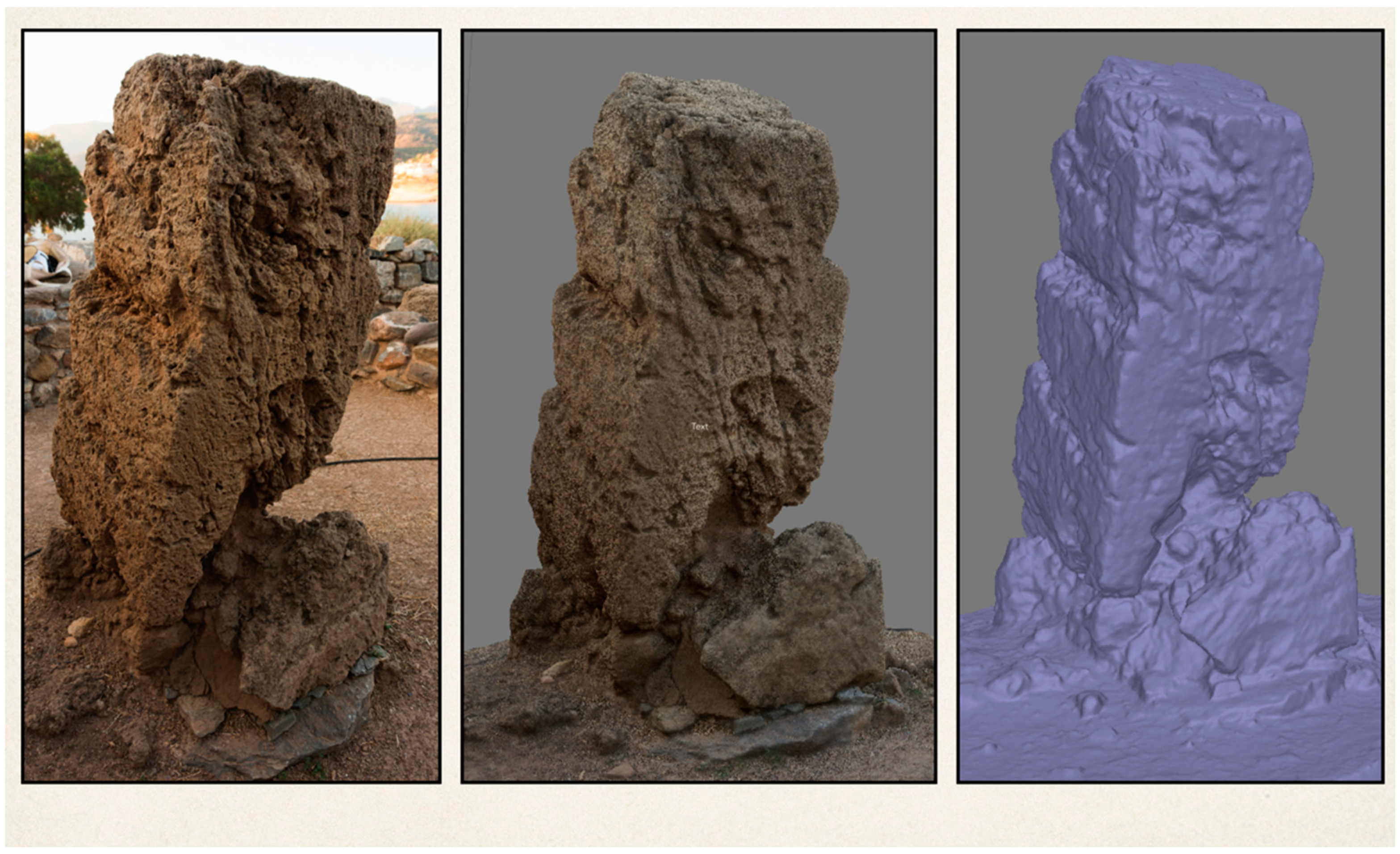
Figure 7). At the third level, selected architectural components, such as walls, pillars, and stairs, were recorded (
Figure 8,
Figure 9 and
Figure 10, respectively). Higher priority was given to architectural elements under risk, to acquire their visual 3D records that could outlast the actual component itself (
Figure 9 and
Figure 10).
The two photogrammetric recording campaigns have culminated in the 3D recording of the archaeological site of Pseira almost in its entirety, as well as the models of individual buildings, which could be used in the future for analysis, monitoring, and corroboration of the survey data. Furthermore, the large amount of raw data acquired as photographs can serve as an auxiliary database for close monitoring of architectural elements and integrity of the structures. In this view, in addition to photogrammetric documentation’s integration to GIS, another future perspective would be the utilization of computer vision technology and to detect degradation and physical alteration phenomena through automated image processing.
The next phase of the program is to determine the techniques and the workflow that will best serve the needs of the sites under examination and to finalize a methodology, which can be easily adapted and applied to sites with similar characteristics. We still have a long way to go as any procedures and methodologies we may develop will still have to be tested in the field by those who are actually called to undertake the real task of the conservation and management of the numerous rural and remote sites of Greece.
7. Conclusions and Future Research
The consequences of inadequate conservation in archaeological sites and the need to integrate conservation into archaeology, are increasingly acknowledged, as the cumulative effects of weathering are being attested at sites that were excavated in the past century. It is further recognized that numerous rural archaeological sites, which lack monumental value, have been overlooked in the past and are in urgent need for conservation. While the conservation of these sites in their entirety, and especially of those in remote locations, is a difficult and often impossible task, an alternative option, which we have to put forward, is the systematic survey, documentation, and prioritization of their needs. The condition surveys that were implemented at the archaeological sites of Mochlos and Pseira have shown that vulnerability assessment studies can point out the urgent problems that have to be dealt with in priority, in order to prolong the life of the ruins until radical solutions become feasible. Given that there are rarely adequate resources for the conservation of the archaeological context as a whole, ‘rapid condition surveys’ are critical in the establishment of priorities for the effective management of the sites and the wise investment of funds in cost-effective interventions. Moreover, the numerous digital tools and ‘smart applications’, which have been developed over the last years, offer an opportunity to digitally preserve heritage, especially in high-risk countries facing conflict, socio-political unrest, or a prolonged economic recession that usually halts the investment of funds in heritage preservation.
Condition assessment surveys and systematic documentation can also provide insights on the deterioration processes that are taking place, the weathering factors in play, and the degree to which they affect the rate of deterioration, thus expanding our knowledge and understanding of site deterioration. The information that is acquired through surveys and documentation can be utilized in establishing conservation priorities, developing strategies for the long-term sustainability of cultural assets, communicating the problems to the key stakeholders and raising awareness in the local community and the wider public. In conclusion, conducting inventories of archaeological resources, identifying the problems through surveys and condition assessment studies, establishing priorities, and introducing post-treatment monitoring and maintenance programs are fundamental in developing sustainable site preservation practices.
The case studies of the Minoan settlements of Mochlos and Pseira have demonstrated that the involvement of conservation professionals, (conservators, conservation scientists, and engineers), in the early phase of planning and in the decision making process is critical in developing appropriate conservation strategies, while the contribution of humanities is also fundamental in the assessment of the values that have to be taken into account in the establishment of conservation priorities. Moreover, the case studies have affirmed the need for a holistic approach that integrates the contribution of all the disciplines involved in heritage preservation, in order to reach sustainable solutions for the management and protection of archaeological sites. We further need to understand sites as part of a cultural landscape, which is affected by weather, development, tourism, vandalism, and the surrounding biosphere and to seek the relationships which can lead to sustainable conservation strategies for both the cultural and natural worlds.
Future work plan in the framework of the CSI-LA program includes the employment of Geographic Information Systems (GIS) for the integration of all the information that has been recorded so far, and the development of survey and documentation protocols that can be applied in other cases with similar characteristics. Furthermore, our vision for the future is to preserve the architectural remains to a legible state and to create a network of the coastal and island sites of East Crete that can be reached by boat, highlighting the Minoan ports and sea routes and providing an alternative experience to the visitor.

 ,
, 