Reconsidering Sustainable Mobility Patterns in Cultural Route Planning: Andreas Syngrou Avenue, Greece


Abstract
:1. Introduction
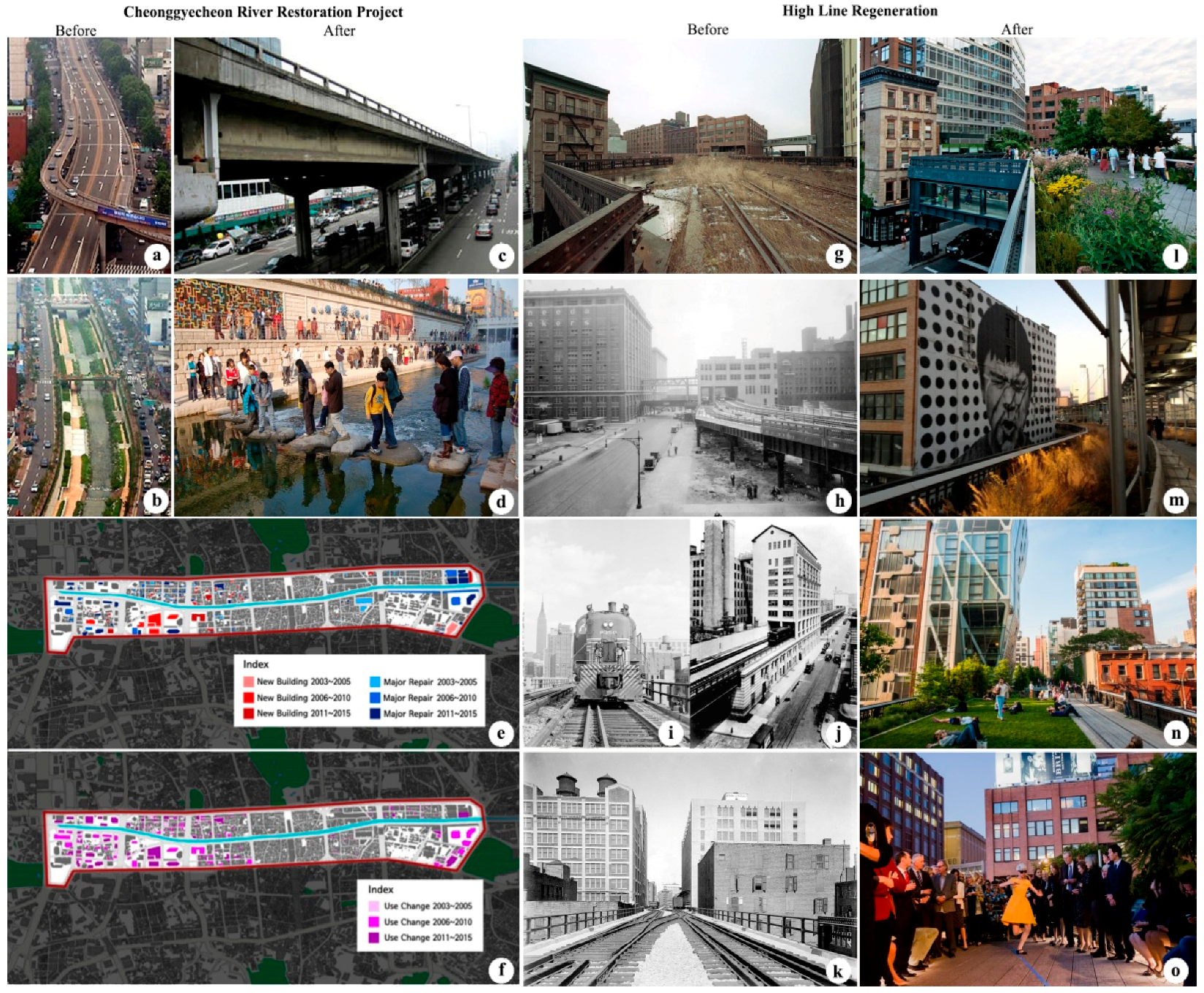
2. Review of Cultural Regeneration Case Studies
3. Case Study Research
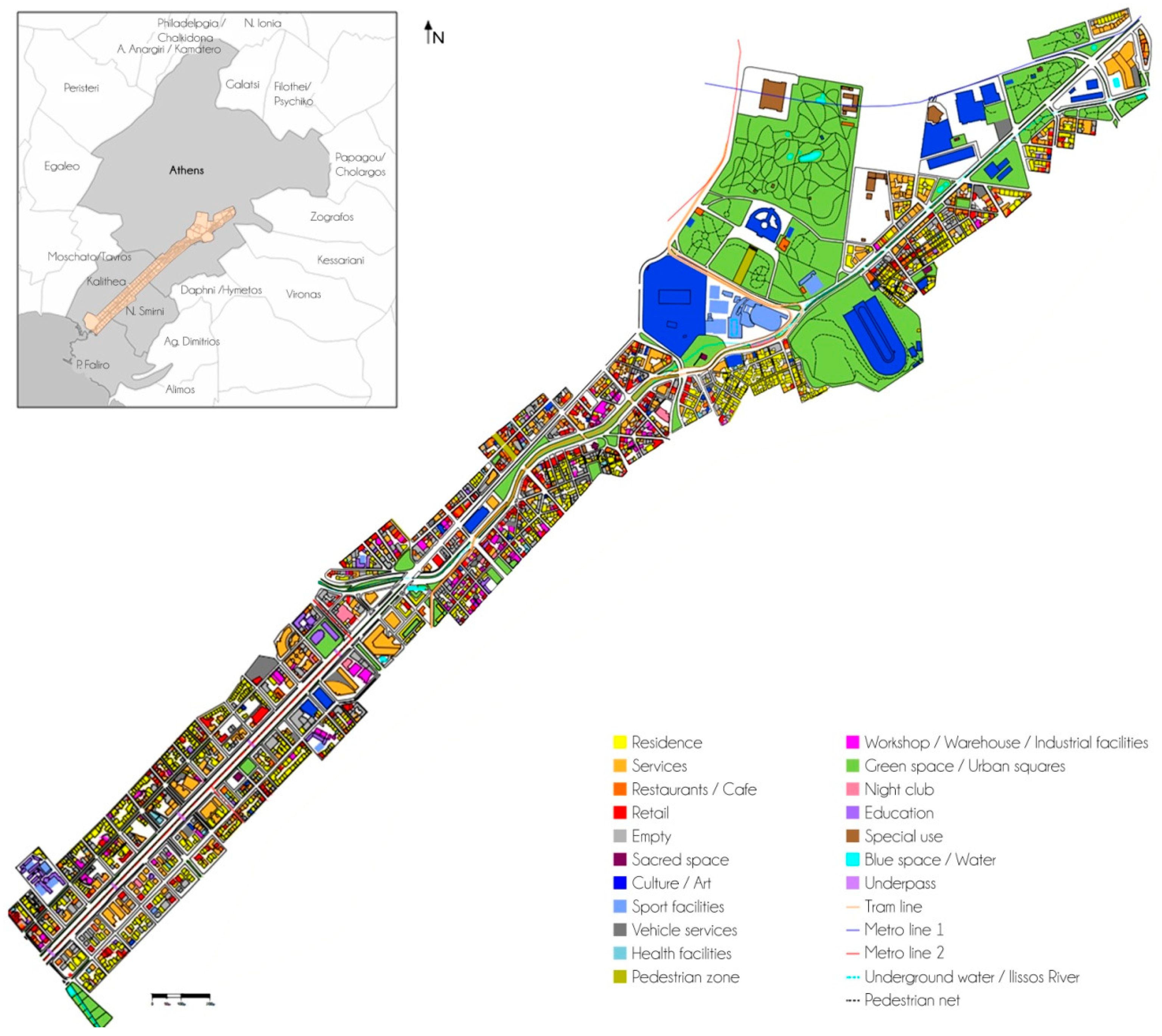
3.1. The Case Study Area
3.2. Methodology
- Analysis of the current state: At this stage, the analysis aims at shedding light on the: (a) Geometric and functional characteristics of the examined road axis; and (b) the land uses and other urban features in a 150 m zone, on either side of the axis. Field research was carried out in 2017. At first, the research team focused on recording the current geometric characteristics of this complex and vital cultural axis of Athens and developed several cross sections. Crossings and public transport stations were also identified. Secondly, land uses were recorded, taking into consideration the ground and upper floors of the built environment, as well as the architectural features for buildings within the 150 m zone. In both cases, photographic documentation was also used to capture the urban and social characteristics along the axis [75].
- Having assessed the most critical issues in the study area at hand and the suitable practices identified by the two case studies in Seoul and New York that could eventually be transferred to the study region, alternative plan proposals were drafted. More specifically, three alternative scenarios were structured, which were diversified on the basis of the extent of interventions introduced by them and their cost (zero, conservative, and visionary). The focus of all three scenarios was on the promotion of sustainable mobility and ITS in order for the cultural character of the area to be enhanced. The reason why those issues formed the basis of the scenarios’ evaluation was related to the character of the project as well as with the suggestions derived by the planning policy documents.
- The proposed scenarios were evaluated by use of multicriteria analysis in order for a decision to be made as to the most relevant one, taking into consideration specific evaluation criteria properly rated as to their importance (criteria weights) [80]. Although the quantification of data was not a priority and qualitative data may be treated as superior, in the context of multicriteria analysis, quantification was also attempted.
3.3. Study of the Current State
- There is a lack of proper management and coordination of existing cultural infrastructure/landmarks as a whole. Also, efforts to host cultural events or coordinated action to inform visitors about cultural activities in the area (e.g., museums or theaters) are missing. There is also currently no concern for a coherent mapping of the aforementioned landmarks as parts of a culturally vibrant axis or for branding of the place as such in a systematic way.
- Urban plans of neighborhood municipalities do not grasp or take steps to address the cultural prospects of the axis. Each municipality plan perceives this axis as a “border”, i.e., an obstacle and not an opportunity. Although, in the Spatial Plan of the Athens Metropolitan Area, a provision for the enhancement of the axis as a cultural route is stated [18].
- Moreover, the existence of derelict buildings and several nightclubs, combined with the documented shadow economy activities, create a sense of insecurity for all road users during the late evening hours. The new national policy for upgrading all municipal plans stands as a great opportunity for the area. Future planning should identify land use conflicts in order to mitigate them.
- The poor quality of the public space and the fragmentation of existing free spaces affects the overall recognition and operation of the area as a cultural route. Many parks are neither related nor connected to each other. Urban furniture is worn out, sculptures are vandalized, and inadequate lighting welcomes delinquent groups. Public spaces do not coexist with cultural facilities. The National Gallery and the National Museum of Contemporary Art are known for their absence of provision for a public reception area and for their inability to host outdoor events.
- The whole road axis is not considered a pedestrian-friendly one. Table 1 summarizes the individual characteristics of each road section. Findings show that it is a highway road link with intense traffic volume at all times. Sidewalks are narrow and below the legal standards [89]. In relation to the drive lane width, it is worth mentioning that sidewalks occupy no more than 16% of the overall section. Very few crosswalks and street obstacles prove further that the axis operates exclusively as a car traffic channel and also as a barrier, according to the Lynch [90] approach, thus resulting in a functional separation of the areas. Due to the high vehicle speeds and the lack of exclusive bicycle infrastructure, the axis is also unfriendly for cyclists.
3.4. Proposals
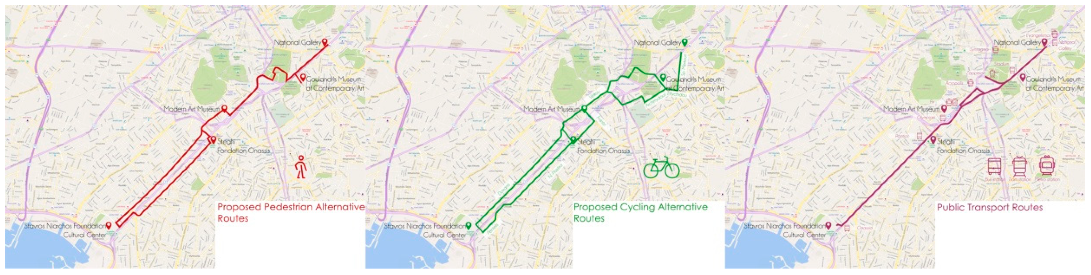
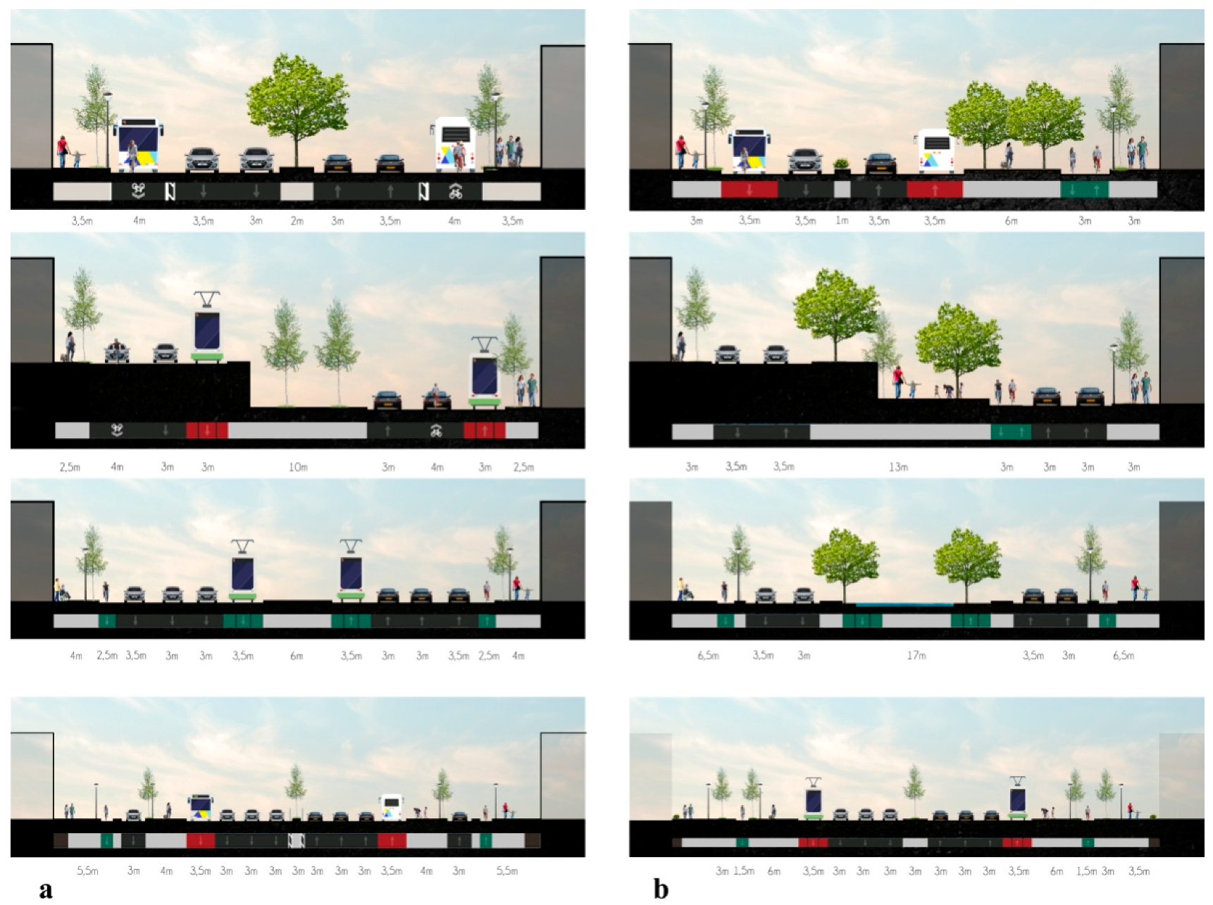
- Do nothing scenario: This considers the current austerity policies and proposes no intervention in transportation and urban planning terms. It attempts solely to assist anyone commuting in the area as a pedestrian or a cyclist, providing alternative routes located in parallel roads with more relevant geometric features and less traffic, such as the Doiranis and Plastira Street. Information on these routes (Figure 4) can be communicated to citizens through information signs in front of points of interest, such as cultural landmarks. At the same time, information regarding the closest public transport station and links to all cultural sites are proposed. In a more refined version of this scenario, a dedicated website of this area is created, which provides information on commuting options and cultural landmarks, while these data can also be uploaded to existing information portals.
- Conservative scenario: This scenario focuses on the implementation of a series of interventions that include the deployment of walking and cycling pathways alongside public transport routes. In this context, widening of the sidewalks along the whole axis is predicted, with a minimum width of 2.5 m, in order to ensure the minimum unobscured pedestrian corridor width (Figure 5). Bike lanes along Kallirois Street and Syngrou Avenue are also incorporated in this scenario. Ardittou Street and Vasileos Konstantinos Avenue are turned into cycle streets and in parts of them cyclists move along an exclusively shared bus–bike lane. In that way, safety for bikers is increased. Driving lanes are reduced to one per direction in Syngrou Avenue in order to leave aside exclusive bus lanes. Service roads also face a similar road change to include bike lanes and wider sidewalks. “Smart boards” are to be installed around the study area in order to provide information about nearby cultural landmarks and recreational facilities and events along the axis.
- Visionary scenario—progressive: This scenario imposes radical and more visionary nature interventions that result in the modification of traffic flows and priorities, while they significantly increase sustainable mobility infrastructures. This scenario is in alignment with the proposal from Anaplasi Athinas S.A. (the “Regeneration of Athens”) that has recently come to the forefront as a means for Ilissos’ revelation and the creation of a linear park [81], which will unite half of the cultural landmarks in the studied cultural axis (Figure 6). It is crucial that such a plan is also supported by the existing problem concerning the function of the tram line. By appropriating this idea, the high cost of the repair works is eliminated while the soil erosion problem is finally solved by promoting an environmental friendly proposal.
- (a)
- The development of a smart parking system for informing drivers via electronic variable message signs and smartphones about the available parking spaces, reducing the time needed to find a parking space, improving traffic and environmental conditions, and increasing road safety levels ([96]).
- (b)
- Installation in the area of smart lighting connected to traffic counters, which adapt their operation to further promote walkability. Bicycle traffic lights can further enhance bike circulation. Moreover, flashing Light-Emitting Diodes (LED) strips complement the safety aspects of pedestrians.
- (c)
- Sustainable mobility in the overall area of the cultural axis area is also promoted through the development of a smart bicycle and e-scooter system for the enhancement of small scale mobility. This action can be implemented either with the cooperation of all neighboring municipalities or by a potential managerial body, who can handle all relevant activities within the cultural axis area.
- (d)
- The placement of “smart boards” is incorporated in this scenario in order to inform the public about all activities in the overall area of the cultural axis.
- (e)
- A network of Wi-Fi nodes is also deployed along the axis, which will allow the area to be identified as a broadband environment, supporting various e-services and enhancing urban intelligence [97].
- (f)
- A smart city application that rewards people for sustainable commuting choices in daily travel. Commuters who use means of public transport, walk, or bike earn points. In exchange, they can participate in challenges and accumulate points redeemable for gifts and discounts. Most of the rewards could be associated with cultural activities in the emerging cultural axis, such as a free admission to a museum or a cultural event. Moreover, through such an application, ticket packages can be developed. Such ticket packages can provide access to the Athens public transport system along with several deals (discounted admission) on some museums in and around the emerging cultural axis.
- Promotion of sustainable mobility: It refers to the performance of scenarios as to the promotion of alternative means of transportation (walking, cycling, public transport). A qualitative scale (−/+) was used for assessing scenarios’ performance with respect to this criterion. The do nothing scenario retains the problems, discouraging the promotion of sustainable mobility; it gets a negative score (−). The conservative scenario creates certain opportunities and it gets a positive, yet contained score (+). The visionary scenario reforms the transportation network, pushing people to try alternative transportation habits; the scores is strongly positive (+3). Upgrade of the environment: It is related to the impact of the proposed interventions on the overall urban environment of the area. A qualitative scale was also used for this criterion. The do nothing scenario will degrade the urban fabric; it gets a negative score (−). This negative score is also supported by the fact that existing planning policy documents suggest specific interventions that might not be implemented in the case that a spatially focused plan does not include them. The conservative scenario gets a positive, yet contained score (+). The visionary scenario greatly enhances the urban space; the scores is strongly positive (+3). The positive score is related to the direct correlation between this proposal and the existing planning policy.
- Overall cost of interventions: Related to the costs involved in the implementation of the proposed scenarios. The do nothing scenario does not require significant funds so the score is 0. The conservative scenario has many expenses and it gets a negative score (−2.5). In those expenses, the cost for repairing the tram line function is also included. In fact, the cost of repair works is so high that there will be a possibility that the works may not be completed. In case that happens, the tram line will be interrupted from the Neos Kosmos to Syntagma stops and the provision of the Regulatory Plan of Athens that the tram line will be extended until Patisia is canceled. The visionary scenario demands great interventions, plantations, and other amenities; the score is strongly negative (−3).
- Traffic service level: This is aimed at studying the impact of interventions on traffic flows and delays on the road axis. In this case, the interval quantitative scale was used. The do nothing scenario does not affect the vehicle space, so the score is 0. The conservative scenario has a few vehicle lanes cut off and it gets a negative score of −1.5. The visionary scenario instructs that some of the vehicle lanes must be removed; the score is −2.
4. Discussion
5. Conclusions
- The emergence and regeneration of cultural areas is a practice that can enhance the social and economic life of Greek cities, especially during this recession period. This can alter the character of regions or cities and even the citizens’ culture. Long-term effects also include the strengthening of tourists’ attraction in previously neglected downgraded zones, thus leading to their cultural and economic revitalization.
- Citizens’ presence in public places is essential. Although Greece had a tradition regarding lively cities and vivid squares, contemporary lifestyle and consumerism have altered its physiognomy, thus breaking down the relationship between people and space. Austerity policies can be identified as an opportunity for re-inventing and further investing in public spaces as well as for shifting to alternative costless means of transport, which is at the heart of SUMPs.
- The use of smart tools and intelligent transport systems (ITSs) can further attract visitors (residents and tourists) and extend their presence in the proposed culturally regenerated area, while also going hand in hand with sustainable urban mobility policies towards the establishment of synergies that improve urban qualities. Both can also steer the entrepreneurial attractiveness of the study area.
- Both research fields, i.e., cultural regeneration and SUMPs, have common goals and create positive developmental motivation wherever they are applied, as depicted by culturally regenerated areas around the world, which are commonly surrounded by pedestrian pathways and linked to neighboring centralities through public transport.
- Both cultural regeneration and sustainable mobility policies have a common target: The operational and conceptual unification of city spaces. Exploring and understanding the desirable role and function of public spaces in a city can be investigated in two ways: The recording of land uses and activities that take place across the city/study area as well understanding people’s needs (use of public transport, resting areas, playgrounds, etc.) that are expressed through specific behaviors. Thus, it seems necessary for urban planners to use not only conventional methods to analyze the existing situation of an area but also modern innovative tools.
- An innovative method was used in the case study presented above: Crowdsourcing. This technique is related to public engagement in order for data to be collected. In the case study examined above, the obtained data were related to the form and function of the study area and they were derived without any involvement of volunteers (Google maps and Open Street Map platforms). However, in case urban planners are interested in collecting additional quantitative (i.e., noise levels) or qualitative data (i.e., main problems or solutions proposed by users, interest in arts/culture, motives for using public transport), this technique could be useful in the primary data collection process.
- Applying good practices means learning from and through the experience of others, in Greece or abroad. It is a technique that has proven to reliably lead to a desired result concerning action plan preparation and an ex-ante evaluation of the proposed interventions. Indeed, through comparison with similar plans, a risk analysis as well as the outcome of such interventions both in mobility as well as cultural terms could be estimated.
- As far as the action plan is concerned, it should focus not only on the physical design of an area but also on its management. Taking into consideration that Greeks prefer to travel around cities by car, sustainable mobility interventions may not have a clearly positive impact with regard to social acceptance at the initial stage of their implementation. Thus, to encourage the use of public transportation, incentives may be offered to potential users. This paper developed such a mixed motivation: A reward system for citizens and tourists that use public transportation. Users of public transport were awarded free admissions to museums and cultural sites across the emerging cultural axis, by using a mobile application. This could be a typical example of an intensive method that can be used in order for sustainable mobility to be promoted and citizens and tourists to be attracted in cultural clusters.
- Technology should be an important component of such a proposal. Only in that way is it possible for a reward policy to be applied. At the same time, when innovative installations are placed in an area, it is easily perceived as a special district.
- The key to a proposal evaluation and an optimal scenario choice is having in mind the common goal of the promotion of sustainable mobility and the development of a successful cultural district. Evaluations focused more on one direction should not be accepted. Dysfunctions may emerge in the near future.
Author Contributions
Funding
Conflicts of Interest
References
- McGreal, S.; Adair, A.; Berry, J.; Deddis, B.; Hirst, S. Accessing private sector finance in urban regeneration: Investor and non-investor perspectives. J. Prop. Res. 2000, 17, 109–131. [Google Scholar] [CrossRef]
- Davies, J. The governance of urban regeneration: A critiques of the “governing without government” thesis. Public Adm. 2002, 80, 301–322. [Google Scholar] [CrossRef]
- Kyriakidis, C.; Siolas, A. Leisure and cultural clusters as a means of growth. The case study of the Commercial Triangle in Athens. In Proceedings of the 11th Tactical Scientific Conference ERSA-GR, Patras, Greece, 14–15 June 2013. [Google Scholar]
- Nobre, E. Urban regeneration experiences in Brazil: Historical preservation, tourism development and gentrification in Salvador da Bahia. Urban Des. Int. 2002, 7, 109–124. [Google Scholar] [CrossRef]
- Dabinett, G. Realizing regeneration benefits from urban infrastructure investment: Lessons from Sheffield in the 1990s. Town Plan. Rev. 1998, 69, 171–189. [Google Scholar] [CrossRef]
- Plaza, B.; Haarich, S. Museums for urban regeneration? Exploring conditions for their effectiveness. J. Urban Regen. Renew. 2009, 2, 259–271. [Google Scholar]
- Montgomery, J. Cultural quarters as mechanisms for urban regeneration. Part 1: Conceptualizing cultural quarters. Plan. Pract. Res. 2003, 18, 293–306. [Google Scholar] [CrossRef]
- McCarthy, J. Regeneration of cultural quarters: Public art for lace image or place identity? J. Urban Des. 2006, 11, 243–262. [Google Scholar] [CrossRef]
- Gospodini, A. Shaping, interpreting and classifying the new landscapes of the post-city. In The New Urban Landscapes and the GREEK City; Gospodini, A., Beriatos, E., Eds.; Kritiki Publishing: Athens, Greece, 2006; pp. 26–51. [Google Scholar]
- Smith, M. Introduction. In Tourism, Culture and Regeneration; Smith, M., Ed.; CAB International: Oxfordshire/Cambridge, UK, 2007. [Google Scholar]
- Bianchini, F. Remaking European cities: The role of cultural policies. In Cultural Policy and Urban Regeneration. The West European Experience; Bianchini, F., Parkinson, M., Eds.; Manchester University Press: Manchester, UK, 1993; pp. 1–20. [Google Scholar]
- Souliotis, N. Cultural strategies and urban regeneration in the historic centre of Athens: Local conditions and global trends. In Proceedings of the 2nd Pan-Hellenic Conference of Urban Planning and Regional Development, Volos, Greece, 24–27 September 2009. [Google Scholar]
- Yelinek, A. Culture as a Tool for Urban Regeneration. 2009. Available online: http://www.jiis.org/.upload/publications/culture%20and%20urban%20regeneration.pdf (accessed on 28 August 2011).
- Gospodini, A. European cities in competition and the new uses of urban design. J. Urban Des. 2002, 1, 59–74. [Google Scholar] [CrossRef]
- Martone, A.; Sepe, M. Creativity, urban regeneration and sustainability/The Bordeaux case study. J. Urban Regen. Renew. 2012, 5, 164–183. [Google Scholar]
- Mommaas, H. Cultural clusters and the post-industrial city: Towards the remapping of urban cultural policy. Urban Stud. 2004, 41, 507–532. [Google Scholar] [CrossRef]
- Bakogiannis, E.; Kyriakidis, C.; Siti, M.; Koumparakis, G.; Athanasoglou, C. Identifying sustainable measures in medium-sized Greek cities. Urban. Inf. Spec. Issue 2018, 278, 8–12. [Google Scholar]
- Act 4277/2014 (FEK –Official Gazette A’ 156/1-8-2014). Available online: https://www.e-nomothesia.gr/kat-periballon/skhedia-poleon/n-4277-2014.html (accessed on 30 May 2019).
- Act 4599/2019 (FEK –Official Gazette 40/A/4-3-2019). Available online: https://www.e-nomothesia.gr/kat-aytokinita/adeies-odegeses/nomos-4599-2019-phek-40a-4-3-2019.html (accessed on 30 May 2019).
- Evans, G. Hard-branding the cultural city from Prado to Parada. Int. J. Urban Reg. Res. 2003, 27, 417–440. [Google Scholar] [CrossRef]
- Miles, S.; Paddison, R. Introduction: The rise and rise of culture-led urban regeneration. Urban Stud. 2005, 42, 833–839. [Google Scholar] [CrossRef]
- Lin, C.Y.; Hsing, W.C. Culture-led urban regeneration and community mobilization: The case of the Taipei Bao-An Temple AREA, Taiwan. Urban Stud. 2009, 46, 1317–1342. [Google Scholar] [CrossRef]
- Rodriguez, A.; Martinez, E. Restructuring cities. Miracles and mirages in urban revitalization in Bilbao. In The Globalized City. Economic Restructuring and Social Polarization in European Cities; Moulaert, F., Rodriguez, A., Swyngedouw, E., Eds.; Oxford University Press: New York, NY, USA, 2003. [Google Scholar]
- Shin, J.H.; Lee, I.K. Cheong Gye Cheon restoration in Seoul, Korea. Proc. Inst. Civ. Eng. Civ. Eng. 2006, 159, 162–170. [Google Scholar] [CrossRef]
- Park, K.D. Cheonggyecheon Restoration Project. In Proceedings of the JFES-WFEO Joint International Symposium on River Restoration, Hiroshima, Japan, 13 September 2007; pp. 9–20. [Google Scholar]
- Lee, I.K. Cheong Gye Cheon Restoration Project. 2006. Available online: https://www.irbnet.de/daten/iconda/CIB7972.pdf (accessed on 23 March 2019).
- Institute for Transportation and Development Policy and EMBARQ. The Life and Death of Urban Highways. 2012. Available online: https://3gozaa3xxbpb499ejp30lxc8-wpengine.netdna-ssl.com/wp-content/uploads/2014/07/42.-LifeandDeathofUrbanHighways_031312.pdf (accessed on 22 March 2019).
- Reig, I.B.; Roig, L.B.; Marcenac, V.; Lujan, N.S. Linear parks understood as vertebration instruments of the city. In Proceedings of the 24th ISUF International Conference: City and Territory in the Globalization Age, Valencia, Spain, 27–29 September 2017; pp. 983–993. [Google Scholar]
- Kang, J. AR Teleport: Digitan Reconstruction of historical and cultural-heritage sites for mobile phones via movement-based interactions. Wirel. Pers. Commun. 2013, 70, 1443–1462. [Google Scholar] [CrossRef]
- Ryu, C.; Kwon, Y. How do mega projects alter the city to be more sustainable? Spatial changes following the Seoul Cheonggyecheon restoration project in South Korea. Sustainability 2016, 8, 1178. [Google Scholar] [CrossRef]
- Rukmana, D. Rapid urbanization and the need for sustainable transportation policies in Jakarta. IOP Conf. Ser. Earth Environ. Sci. 2018, 124, 12017–12025. [Google Scholar] [CrossRef]
- Cervero, R. Urban reclamation and regeneration in Seoul, South Korea. In Physical Infrastructure Development: Balancing the Growth, Equity and Environmental Imperatives; Ascher, W., Krupp, C., Eds.; Palgrave Macmillan: New York, NY, USA, 2010; pp. 187–201. [Google Scholar]
- Shin, J.; Park, H.; Seo, J.; Lee, J.; Park, H. Analysis of local and periodical transition in Cheong-Gye-Cheon to harmonize locality for urban green growth. J. Civ. Eng. 2014, 19, 2005–2016. [Google Scholar] [CrossRef]
- Park, H.; Shin, J. Localities and Urban Green Growth: Half century’s revitalization of Cheon-Gye-Cheon (CGC) in Seoul. Korea World Econ. 2017, 18, 167–203. [Google Scholar]
- Khanal, P.; Gurung, A.; Chand, P.B. Road expansion and urban highways: Consequences outweigh benefits in Kathmadu. HIMALAYA J. Assoc. Nepal Himal. Stud. 2017, 37, 107–116. [Google Scholar]
- Kriznik, B. Selling global Seoul: Competitive urban policy and symbolic reconstruction of cities. Rev. Za Sociol. 2011, 41, 291–313. [Google Scholar] [CrossRef]
- Shafray, E.; Kim, S. A study of walkable spaces with natural elements for urban regeneration: A focus on cases in Seoul, South Korea. Sustainability 2017, 9, 587. [Google Scholar] [CrossRef]
- Winifred, C.; Hamilton, T. Forward. In Just Green Enough. Urban Development and Environmental Certification; Winifred, C., Hamilton, T., Eds.; Routledge: Abingdon, UK; New York, NY, USA, 2017. [Google Scholar]
- UN HABITAT. Urban Patterns for a Green Economy. Working with Nature; UN-HABITAT: Nairobi, Kenya, 2012. [Google Scholar]
- Yoon, Y. Cheonggyecheon Restoration Project: The politics and implications of globalization and gentrification. Dartm. Undergrad. J. Politics Econ. World Aff. 2018, 1, 8. [Google Scholar]
- Ipingbemi, O. Green transport for Nigerian cities. In Building Clean Cities in Nigeria; Wahab, B., Atebije, N., Yunusa, I., Eds.; NITP and TOPREC: Abuja, Nigeria, 2014. [Google Scholar]
- Lee, J.Y.; Anderson, C.D. The restored Cheonggyecheon and the quality of life in Seoul. J. Urban Technol. 2014, 20, 3–22. [Google Scholar] [CrossRef]
- Ascher, K.; Uffer, S. The High Line Effect; Council on Tall Buildings; Urban Habitata: New York, NY, USA, 2015; Available online: http://global.ctbuh.org/resources/papers/download/2463-the-high-line-effect.pdf (accessed on 24 March 2019).
- Porter, A.; Ashton, A. Highline Park. 2003. Available online: http://ashtonporter.com/all-projects/cultural/highline/ (accessed on 24 March 2019).
- Aitani, K.; Sathaye, V.K. New York High Line as urban catalyst: Impact to neighborhood. In Proceedings of the 24th ISUF International Conference: City and Territory in the Globalization Age, Valencia, Spain, 27–29 September 2017; pp. 1665–1672. [Google Scholar]
- Harrison, R. Transformation of Urban Public Space. Master’s Thesis, University of Massachusetts Amherst, Massachusetts, MA, USA, 2012. Available online: https://scholarworks.umass.edu/ cgi/viewcontent.cgi?article=1972&context=theses (accessed on 22 March 2019).
- Toni, A.; Abdollahi, S. Kilometro Zero Tower. 2014. Available online: https://www.politesi.polimi.it/bitstream/10589/90444/1/2014_04_Toni_Abdollahi_01.pdf (accessed on 24 March 2019).
- Mayer, P.; Saunders, M.J. Regenerating the core—Or is it periphery? Reclaiming waterfronts in US cities. In The Routledge Companion to Urban Regeneration; Leary, M., McCarthy, J., Eds.; Routledge: London, UK; New York, NY, USA, 2013; pp. 179–189. [Google Scholar]
- Bakogiannis, E. Good Practices for Promoting Sustainable Urban Mobility, 1st ed.; Gregoris Publications: Athens, Greece, 2018. [Google Scholar]
- Foster, J. Off Track, In Nature: Constructing ecology on old rail lines in Paris and New York. Nat. Cult. 2010, 5, 316–337. [Google Scholar] [CrossRef]
- Anon. Cheonggyecheon Stream The Restoration Project. Available online: http://blogtalkwithejay.blogspot.com/2014/10/cheonggyecheon-stream-restoration.html (accessed on 29 March 2019).
- Tran, C. Seoul/Cheonggyecheon, the Symbol of the Modernity. 2014. Available online: http://fac.arch.hku.hk/asian-cities-research/seoul-cheonggyecheon-the-symbol-of-the-modernity/ (accessed on 29 March 2019).
- Herwing, O. Go with the Flow. 2016. Available online: https://www.smart-magazine.com/restoring-cheonggyecheon-river/ (accessed on 29 March 2019).
- The New York Times. Before and After Bloomberg. 2016. Available online: https://archive.nytimes.com/www.nytimes.com/interactive/2013/08/18/nyregion/before-and-after-bloomberg.html (accessed on 29 March 2019).
- Anon. Go for Walk and Discover the High Line in New York. 2018. Available online: https://www.new-york-city-travel-tips.com/go-walk-discover-high-line-new-york/ (accessed on 29 March 2019).
- Wikipedia. High Line. 2019. Available online: https://en.wikipedia.org/wiki/High_Line (accessed on 29 March 2019).
- Columbia University. High Line Construction. Available online: http://ccnmtl.columbia.edu/projects/caseconsortium/casestudies/128/casestudy/www/layout/case_id_128_id_903.html (accessed on 29 March 2019).
- Kid101. The Highline. Available online: https://kid101.com/15-unique-ideas-for-parent-date-in-nyc/the-highline-630x420/ (accessed on 29 March 2019).
- CIRCARQ. High Line. 2013. Available online: https://circarq.wordpress.com/2013/05/22/high-line/ (accessed on 29 March 2019).
- The Highline.org. High Line Art Dinner. 2018. Available online: https://www.thehighline.org/art-dinner/? (accessed on 29 March 2019).
- Moss, J. Disney World on the Hudson. 2012. Available online: http://www.nytimes.com/2012/08/22/opinion/in-the-shadows-of-the-high-line.html (accessed on 24 March 2019).
- Nonko, E. Ten Development Changing the New York City Landscape. 2014. Available online: http://www.newyork.com/articles/real-estate/10-developments-changing-the-new-york-city-landscape-60742 / (accessed on 24 March 2019).
- Shafray, E.; Kim, S. Approaching the issues of urban waterstreams organization as a new city landscape: Focused on Case Studied in Seoul, South Korea. J. Eng. Technol. 2016, 4, 53–58. [Google Scholar]
- Kyriakidis, C. The function of urban public space in relation to local parameters: Comparative study between Larisa and Nottingham. Aeichoros 2016, 24, 67–85. [Google Scholar]
- Vlastos, T.H.; Milakis, D. Urban Planning vs Transportation. From Divergence to Convergence; ORSA; NTUA: Athens, Greece, 2006. [Google Scholar]
- Vlastos, T.H.; Chatzidouros, A. Cutting-edge technologies in the service of a new philosophy for public transport. In Proceedings of the Conference: Public Transportation in the Athens Metropolitan Area, Athens, Greece, 15–16 June 1998; pp. 185–193. [Google Scholar]
- Thomas, G. A Typology for the Case Study in Social Science Following a Review of Definition, Discourse and Structure, Qualitative Inquiry. 2011. Available online: http://qix.sagepub.com/content/17/6/511 (accessed on 4 June 2014).
- Yin, R.K. Case Study Research: Design and Methods; Sage: Newbury Park, CA, USA, 1984. [Google Scholar]
- Zainal, Z. Case study as a research method. J. Kemanus. 2007, 5, 1–6. [Google Scholar]
- Hammersley, M.; Gomm, R. Introduction. In Case Study Method. Key Issues, Key Texts; Gomm, E., Hammersley, M., Foster, P., Eds.; Sage Publications: Thousand Oaks, CA, USA, 2000. [Google Scholar]
- Bakogiannis, E.; Siti, M.; Vassi, A.; Christodoulopoulou, G.; Kyriakidis, C. Case studies and sustainable urban mobility research schemes: A communication channel among researchers and interdisciplinary community groups. Int. J. Serv. Sci. Manag. Eng. 2014, 1, 42–51. [Google Scholar]
- Cervero, R. The Traznsit Metropolis: A Global Inquiry; Island Press: Washington, DC, USA, 1998. [Google Scholar]
- Meyer, M.D.; Miller, E.J. Urban Transportation Planning: A Decision-Oriented Approach; McGraw-Hill: New York, NY, USA, 2001. [Google Scholar]
- Banister, D. Unsustainable Transport: City Transport in the New Century; Routledge: London, UK, 2005. [Google Scholar]
- Kyriakidis, C.; Bakogiannis, E. How the physical characteristics may affect the social life of streets in Athens, Greece? Eur. J. Soc. Sci. Educ. Res. 2018, 12, 15–23. [Google Scholar] [CrossRef]
- Mourafetis, G.; Apostolopoulos, K.; Potsiou, C.; Ioannidis, C. Enhancing cadastral surveys by facilitating the participation of owners. Surv. Rev. 2015, 47, 316–324. [Google Scholar] [CrossRef]
- Basiouka, S.; Potsiou, C.; Bakogiannis, E. Open Street Map for cadastral purposes: An application using VGI for official processes in urban areas. Surv. Rev. 2015, 47, 333–341. [Google Scholar] [CrossRef]
- Bakogiannis, E.; Kyriakidis, C.; Siti, M.; Milioni, T.; Potsiou, C. Increasing urban resilience of Athens’ Historic Center. In Proceedings of the FIG Working Week 2017, Helsinki, Finland, 29 May–2 June 2017. [Google Scholar]
- Kyriakidis, C.; Bakogiannis, E.; Siolas, A. Identifying environmental affordances in Kypseli Square in Athens, Greece. In Proceedings of the International Conference on Social Sciences (ICONSOS) 2018, New York, NY, USA, 17–19 September 2017. [Google Scholar]
- Giaoutzi, M.; Stratigea, A. Rural Planning: Theory and Practice; Kritiki Publications: Athens, Greece, 2011. [Google Scholar]
- Lialios, G. Creating a Green Trail in Ilisos River. 2019. Available online: http://www.kathimerini.gr/1010757/gallery/epikairothta/ellada/diadromh-prasinoy-me-fonto-ton-iliso (accessed on 26 March 2019).
- Ypodomes. Syngrou Ave. The Avenue Where Large Hotel Names Are Located in 2019. Available online: https://www.ypodomes.com/index.php/alles-ypodomes/touristikes-ypodomes-tourismos/item/52134-syggroy-i-leoforos-ton-megalon-ksenodoxeiakon-ependyseon (accessed on 28 March 2019).
- Aixmi. Free Open-Air Cinema Every Friday in SNCC. 2016. Available online: https://www.aixmi.gr/index.php/dvrean-uerino-sinema-kaue-paraskeyh-sto-stayros-niarxos/ (accessed on 28 March 2019).
- Nikolopoulos, E. Europe says “YES” in Steghi Onasis Cultural Center. 2015. Available online: https://m.eirinika.gr/article/116787/nai-stin-eyropi-leei-i-stegi-grammaton-kai-tehnon-o-politismos-mas-enonei-agkaliazei (accessed on 28 March 2019).
- Museum Finder. National Museum of Contemporary Art. Available online: https://museumfinder.gr/item/ethniko-mousio-sygchronis-technis/ (accessed on 28 March 2019).
- Skyscrapercity. Goulandri Museum of Modern Art. Available online: https://www.skyscrapercity.com/showthread.php?p=157248754 (accessed on 28 March 2019).
- Museum Finder. National Gallery. Available online: https://museumfinder.gr/item/ethniki-pinakothiki/ (accessed on 28 March 2019).
- Andro. Editorial. Available online: http://www.andro.gr/apopsi/snfcc-smoking/ (accessed on 28 March 2019).
- Ministerial Decision No 52488/2002 (FEK—Official Gazette 18B/2002): Special Arrangements for Serving the Disabled. Available online: http://www.elinyae.gr/el/lib_file_upload/b18_02.1129800988436.pdf (accessed on 30 May 2019).
- Lynch, K. The Image of the City; MIT Press: Cambridge, MA, USA, 1960. [Google Scholar]
- Bakogiannis, E.; Kyriakidis, C.; Siti, M.; Kourmpa, E. Support accessibility in Stavros Niarchos Foundation Cultural Center in Kallithea. In Proceedings of the 5th Pan-hellenic Conference on Planning and Regional Development, Volos, Greece, 27–30 September 2018. [Google Scholar]
- Strategic Plan for Transportation and Sustainable Mobility in Athens. Available online: http://www.cityofathens.gr/node/19684 (accessed on 9 June 2019).
- Operational Program of the Municipality of Athens (2015–2019). Available online: http://www.cityofathens.gr/node/22020 (accessed on 9 June 2019).
- Vlastos, T.H. Tram: Feasible to function in Athens? Seven Days: Tram interventions in the past and nowadays. 2005; 16–19. [Google Scholar]
- Stratigea, A. The concept of “smart cities”. Towards community development? Netcom Netw. Commun. Stud. 2012, 26, 375–388. [Google Scholar] [CrossRef]
- Spiropoulou, I.; Yannis, G.; Golias, J.; Karlautis, M. Impact of the Use of Developed Information Systems for Road Transport. 2016. Available online: http://library.tee.gr/digital/m2070/m2070_spiropoulou.pdf (accessed on 27 March 2019).
- Komninos, N.; Tsarchopoulos, P. Toward intelligent Thessaloniki: From an agglomeration of Apps to smart districts. J. Knowl. Econ. 2012, 4, 149–168. [Google Scholar] [CrossRef]
- Kang, C.D.; Cervero, R. From elevated freeway to urban greenway: Land value impacts of the CGC project in Seoul, Korea. Urban Stud. 2009, 46, 2771–2794. [Google Scholar] [CrossRef]
- Gore, T.; Eadson, W.; Ozdemiroglu, E.; Gianferrara, E.; Phang, Z. Green Infrastructure’s Contribution to Economic Growth: A Review. Project Report; Sheffield Hallam University: London, UK, 2013; Available online: http://shura.shu.ac.uk/22114/1/11406_GI_Economic_Catalyst_Final_Report_July2013.pdf (accessed on 27 March 2019).
- Zisopoulou, A.; Kazdaglis, M. Addressing the urban heat island effect through strategic planning for promoting sustainable development in Greek cities. In Proceedings of the National Conference on Architecture, Energy and Environment of Buildings and Cities, Athens, Greece, 3–4 May 2011. [Google Scholar]
- Huffpost. Five Most Deadly Storms That Have Taken Place in Attica. Greece Since 1895. All of Them Have Taken Place in November 2017. Available online: https://www.huffingtonpost.gr/2017/11/15/kataigides-attiki-fonikoteres-noemvrio_n_18564200.html (accessed on 27 March 2019).
- Chung, J.H.; Hwang, K.Y.; Bae, Y.K. The loss of road capacity and self-compliance: Lessons from the Cheonggyecheon stream restoration. Transp. Policy 2012, 21, 165–178. [Google Scholar] [CrossRef]
- NACTO. Global Street Design Guide; Island Press: New York, NY, USA, 2016. [Google Scholar]
- Vlastos, T.H.; Barbopoulos, N.; Athanasopoulos, K. Comparative analysis of tram infrastructure in Strasburg and Athens: Initial conclusions on future implementations in Greece. In Proceedings of the 2003 International Conference on Contemporary Tram and LRT Systems, Patras, Greece, 19–20 May 2003. [Google Scholar]
- Loughran, K. Parks for profit: Public space and inequality in New York City. City Community 2014, 13, 49–68. [Google Scholar] [CrossRef]
- Beatley, T. Biophilic Cities. Integrating Nature into Urban Design and Planning; Island Press: Washington, DC, USA, 2011. [Google Scholar]
- Gibson, J. An Ecological Approach to Visual Perception; Houghton Mifflin: Boston, MA, USA, 1979. [Google Scholar]
- Tillas, A.; Vosgerau, G.; Seuchter, T.; Zipoli Caiani, S. Can Affordances Explain Behavior? Rev. Philos. Psychol. 2017, 8, 295–315. [Google Scholar] [CrossRef]
- Whyte, W. The Social Life of Small Urban Spaces; Conservation Foundation: Washington, DC, USA, 1980. [Google Scholar]
- Jacobs, J. The Death and Life of Great American Cities; Random House: New York, NY, USA, 1961. [Google Scholar]
- Vlastos, T.H. Public transportation and sustainable ways of commuting. In Proceedings of the Conference: Effective Traffic Interventions That Promote the Function of Cities, Athens, Greece, 20 June 1997; pp. 33–42. [Google Scholar]


| Street/Avenue | Syngrou Avenue | Kallirois Street | Ardittou Street | V. Konstantinos Avenue |
|---|---|---|---|---|
| Length (km) | 5 | 1.2 | 0.5 | 1.3 |
| Width (m) | 65–70 | 40–53 | 35–38 | 30–40 |
| Lanes/Direction | 4–5 (extra 2) | 3 | 2 | 2 |
| Bus lanes/Direction | 0 | 0 | 0 | 1 |
| Tram Lane | No | Yes | Yes | No |
| Traffic Island | Yes | Yes | Yes | Yes |
| Sidewalks’ width (m.) | 1.7–6.1 | 1.9–5.2 | 2–3.4 | 2.5–5.0 |
| Pedestrian Crossings | 9 underground (every 500 m.) | 5 (Max: every 300 m.) | 3 (Not a specific pattern) | 12 (Max: every 200 m.) |
| Do Nothing Scenario | Conservative Scenario | Visionary Scenario | |
|---|---|---|---|
| Promotion of sustainable mobility | −1 | +1 | +3 |
| Upgrade of the environment | −1 | +1 | +3 |
| Overall cost of interventions | 0 | −2.5 | −3 |
| Traffic service level | 0 | −1.5 | −2 |
| Total | −2 | −2 | +1 |
© 2019 by the authors. Licensee MDPI, Basel, Switzerland. This article is an open access article distributed under the terms and conditions of the Creative Commons Attribution (CC BY) license (http://creativecommons.org/licenses/by/4.0/).
Share and Cite
Bakogiannis, E.; Kyriakidis, C.; Siti, M.; Floropoulou, E. Reconsidering Sustainable Mobility Patterns in Cultural Route Planning: Andreas Syngrou Avenue, Greece. Heritage 2019, 2, 1702-1723. https://doi.org/10.3390/heritage2020104
Bakogiannis E, Kyriakidis C, Siti M, Floropoulou E. Reconsidering Sustainable Mobility Patterns in Cultural Route Planning: Andreas Syngrou Avenue, Greece. Heritage. 2019; 2(2):1702-1723. https://doi.org/10.3390/heritage2020104
Chicago/Turabian StyleBakogiannis, Efthimios, Charalampos Kyriakidis, Maria Siti, and Eleni Floropoulou. 2019. "Reconsidering Sustainable Mobility Patterns in Cultural Route Planning: Andreas Syngrou Avenue, Greece" Heritage 2, no. 2: 1702-1723. https://doi.org/10.3390/heritage2020104
APA StyleBakogiannis, E., Kyriakidis, C., Siti, M., & Floropoulou, E. (2019). Reconsidering Sustainable Mobility Patterns in Cultural Route Planning: Andreas Syngrou Avenue, Greece. Heritage, 2(2), 1702-1723. https://doi.org/10.3390/heritage2020104