Article

Estimating Tree Height and Volume Using Unmanned Aerial Vehicle Photography and SfM Technology, with Verification of Result Accuracy

by
Shohei Kameyama
1 and
Katsuaki Sugiura
2,*
1
Graduate School of Bioresource Sciences, Nihon University, 1866 Kameino, Fujisawa, Kanagawa 252-0880, Japan
2
College of Bioresource Sciences, Nihon University, 1866 Kameino, Fujisawa, Kanagawa 252-0880, Japan
*
Author to whom correspondence should be addressed.
Drones 2020, 4(2), 19; https://doi.org/10.3390/drones4020019
Submission received: 18 March 2020 / Revised: 7 May 2020 / Accepted: 9 May 2020 / Published: 11 May 2020

Abstract

:
This study aimed to investigate the effects of differences in shooting and flight conditions for an unmanned aerial vehicle (UAV) on the processing method and estimated results of aerial images. Forest images were acquired under 80 different conditions, combining various aerial photography methods and flight conditions. We verified errors in values measured by the UAV and the measurement accuracy with respect to tree height and volume. Our results showed that aerial images could be processed under all the studied flight conditions. However, although tree height and crown were decipherable in the created 3D model in 64 conditions, they were undecipherable in 16. The standard deviation (SD) in crown area values for each target tree was 0.08 to 0.68 m2. UAV measurements of tree height tended to be lower than the actual values, and the RMSE (root mean square error) was high (5.2 to 7.1 m) through all the 64 modeled conditions. With the estimated volume being lower than the actual volume, the RMSE volume measurements for each flight condition were from 0.31 to 0.4 m3. Therefore, irrespective of flight conditions for UAV measurements, accuracy was low with respect to the actual values.

Graphical Abstract

1. Introduction

An unmanned aerial vehicle (UAV), also called a drone, is the name for any aircraft that can be operated remotely. Presently, there are various small to large models of drones, and these are being utilized for various applications, including pesticide application, disaster damage surveying, logistics, and media. In Japan, the Ministry of Agriculture, Forestry and Fisheries has prepared the “UAV Stand Inventory Manual” [1] for use in forest surveys, which summarizes specific procedures and key points for stand inventory methods using UAV, and provides a formula to estimate the diameter at breast height (DBH) of trees.
Examples of previous studies that use UAV in the field of forests and forestry include surveys of forest information, such as the number of standing trees, tree height, and single tree volume obtained using structure from motion (SfM) technology. SfM calculates the position of the camera and the shape and position of objects based on multiple aerial photography images captured with a UAV [2,3,4,5,6,7,8,9,10,11,12,13,14,15]. Chen et al. developed and evaluated a method of estimating vegetation height on linear disturbances in the Boreal Forest using point clouds derived from UAV photogrammetry and assessed the accuracy and cost of various application scenarios [16]. Moreover, oblique images were used to prepare a digital surface model (DSM) [17] and estimate the aboveground tree biomass [18]. Huang et al. demonstrated that tree canopy structure factors, especially foliar amount or volume, can have a substantial effect on tree height estimation using UAV images [19]. Teng et al. examined an effective method to reconstruct color images measured using a UAV-borne camera with different focal length lenses [20]. These previous surveys were conducted under differing flight conditions, such as using different models of UAV, flight altitude, and the degree of overlap in aerial photographs. When capturing images using a UAV, flight conditions such as flight altitude and degree of overlap in aerial images (overlap and side overlap) cause notable differences in the number and interval of images.
Therefore, the present study focused on the effect of using images of the same site, taken under different flight conditions, on image processing and measurement accuracy. Several other studies have examined the measured values using UAV aerial images taken under different flight conditions. For example, Torres-Sánchez et al. [21] studied the processing time required for the different overlaps that were recorded, and the accuracy was assessed by analyzing tree detection, reconstructed tree volume, and tree height. Domingo et al. [22] analyzed the effects of camera type, image resolution, side overlap, and some practical considerations that often have to be made in operational surveys on the accuracy of biomass model predictions in a tropical woodland using an unmanned aerial system (UAS). Dandois et al. [23] performed, at a single site, a replicated set of image acquisitions that were carried out under cross treatments of lighting, flight altitude, and image overlap. Seifert et al. [24] provide scientific evidence of the influence of altitude, image overlap, and image resolution on a multiview geometry (MVG) reconstruction of a forest from video-based drone imagery. Ni et al. [25] systematically investigated the impact of forward overlaps and image resolutions on the measurements of forest 3D structures using UAV-based stereo imagery over broader ranges of image resolutions (8.6, 17.2, 34.4, 68.8, and 137.6 cm) and forward overlaps (90%, 80%, 70%, and 60%).
The determination of flight conditions varies based on the UAV model, flight application, and the size of the imaging area; thus, preparing a manual for flight conditions is extremely difficult. There are many issues to consider for UAV utilization, such as various flight conditions and differences in tree species. Therefore, in order to utilize UAV in forest management, it is important to accumulate basic data related to estimates of tree height and volume using UAV, for verification of accuracy.
The objective of the present study was to examine the effect of different flight conditions of a UAV on estimations of tree height and volume using aerial image processing and estimates of tree height and volume at a small survey site. A short-term investigation over a small area was conducted in order to reduce the impact of the investigation period. We collected aerial images with a UAV under multiple flight conditions that combined several flight altitude and degrees of overlap in the aerial images. From the analysis of these aerial images and the estimates of tree height and volume, we verified the errors in such estimations made with the use of a UAV and compared the accuracy of these estimations to the results of a tree survey. In addition to this, based on the results of this study, we discuss issues concerning the use of UAV in this paper. In this study, more flight conditions were set than in previous studies [21,22,23,24,25]. Additionally, although this study uses only one case in Japan, the UAV and flight applications used were made by DJI. DJI is a large company that makes a variety of drone and aerial photography products. Therefore, the use of one of their products is important as it expands knowledge of UAV utilization.

2. Materials and Methods

The present study was conducted in the following sequence: (1) aerial photography was conducted with a UAV; (2) aerial images, measurements, and estimates were processed; and (3) the accuracy of measured and estimated values was verified. Details of the conditions for each step and the analytical methods used are provided below.

2.1. Survey Site

The study was set up in a 0.16 ha test site within 144 compartments and 23 subcompartments of the Yakumo Practice Forests of Nihon University located in Yakumo-cho, Futami-gun, Hokkaido (Figure 1). On the four corners of the survey site, we installed aerial targets to make confirmation of the survey area easier in the aerial images captured by the UAV (Figure 1). Aerial photography of the site was performed during November and December 2018. The terrain of the survey site was generally flat, and the stand was a 46-year-old Sakhalin fir plantation. We also conducted a tree survey in the survey site during the same time period as the aerial photography. Parameters of the tree survey were tree height, DBH (1.2 m height), and position of the trees within the survey site. Tree height was measured using Vertex III (Haglof), and DBH was measured with a caliper. Height was measured three times for each tree, and the mean was calculated and used as the measurement of tree height. The tree survey showed that there were 72 target trees with a mean height of 25.2 m/tree and mean volume of 1.09 m3/tree. We ensured the weather was sunny with a wind speed of 0 to 3 m/s and that the UAV flights and aerial photography occurred between 9 am and 11 am.

2.2. Flight Conditions of the UAV

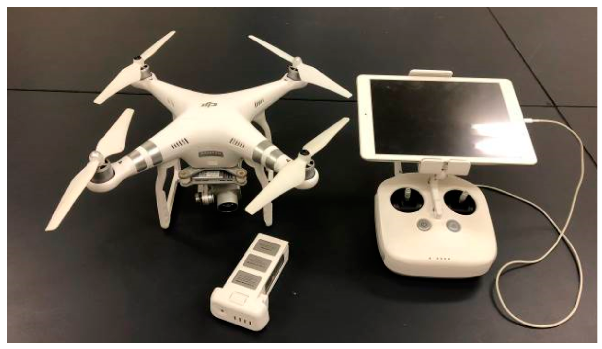
The UAV used was a Phantom3 Advanced (Figure 2) produced by DJI in China. The camera that is a standard feature of the Phantom3 Advanced was used for aerial photography. Specifications of the Phantom3 Advanced and the camera are provided in Table 1 [26]. The DJI drone used in this study was a consumer grade equipment.
The flight altitude of the UAV was to be 150 m above ground level or lower, according to the guideline of the Ministry of Land, Infrastructure, Transport, and Tourism [27]. The survey site provided generally flat areas for takeoff, flight, and landing; thus, as long as the flight altitude of the UAV was 150 m or lower, there were no concerns. However, if the flight altitude was too low, the UAV could come into contact with trees and crash. Therefore, flight altitudes were set at 60, 80, 100, 120, and 140 m (Table 2). Furthermore, the ground sample distances (GSD, i.e., image resolution) were 2.6 cm (when flight altitude = 60 m), 3.5 cm (flight altitude = 80 m), 4.3 cm (flight altitude = 100 m), 5.2 cm (flight altitude = 120 m), and 6.1 cm (flight altitude = 140 m).
In terms of the degree of overlap in aerial images (overlap: degree of overlap in aerial images along the flight path; side overlap: degree of overlap in aerial images between flight paths), the user manual provided for the Terra Mapper Desktop version from TerraDrone [28] used for the SfM processing recommends that the overlap should be 90% or higher and that the side overlap should be 60% or higher. The Manual for Public Survey Using UAV [29] recommends an overlap of 80% or higher and a side overlap of 60% or higher. Therefore, we set the overlap to be 80%, 85%, 90%, and 95% (Table 2). Although a 60% or higher side overlap is recommended, as the flight area of the survey area was small, aerial photography could not be taken between multiple flight paths when the side overlap ratio was low and flight altitude was high. Thus, we set the side overlap to be 80%, 85%, 90%, and 95% (Table 2), where aerial photography between multiple flight paths was possible at the flight altitude of 140 m.
We also set the flight speed and photography method. The flight speed was set at 15.0 m/s (Table 2), which was the maximum speed for the DJI GS PRO flight application [30], in order to shorten the flight time. Photography methods using DJI GS PRO are hovering, equal-time-interval, and equal-distances. However, even-equal-time-interval and equal-distances are performed while the UAV is moving, which may cause blurring of the photos and inaccuracies in the degree of overlap in the photography. Therefore, the photography method selected was hovering to minimize the effect of distortions and blurs on measurement accuracy (Table 2). All aerial images were taken using vertical orientation. In other words, the flight speed and photography method were consistent for all flight conditions. We have not examined oblique images since there are many previous studies by vertical images. The use of an oblique image in a part may improve the processing accuracy of SfM [17]. However, since the vertical shooting is automatic, partial oblique images are not shot.
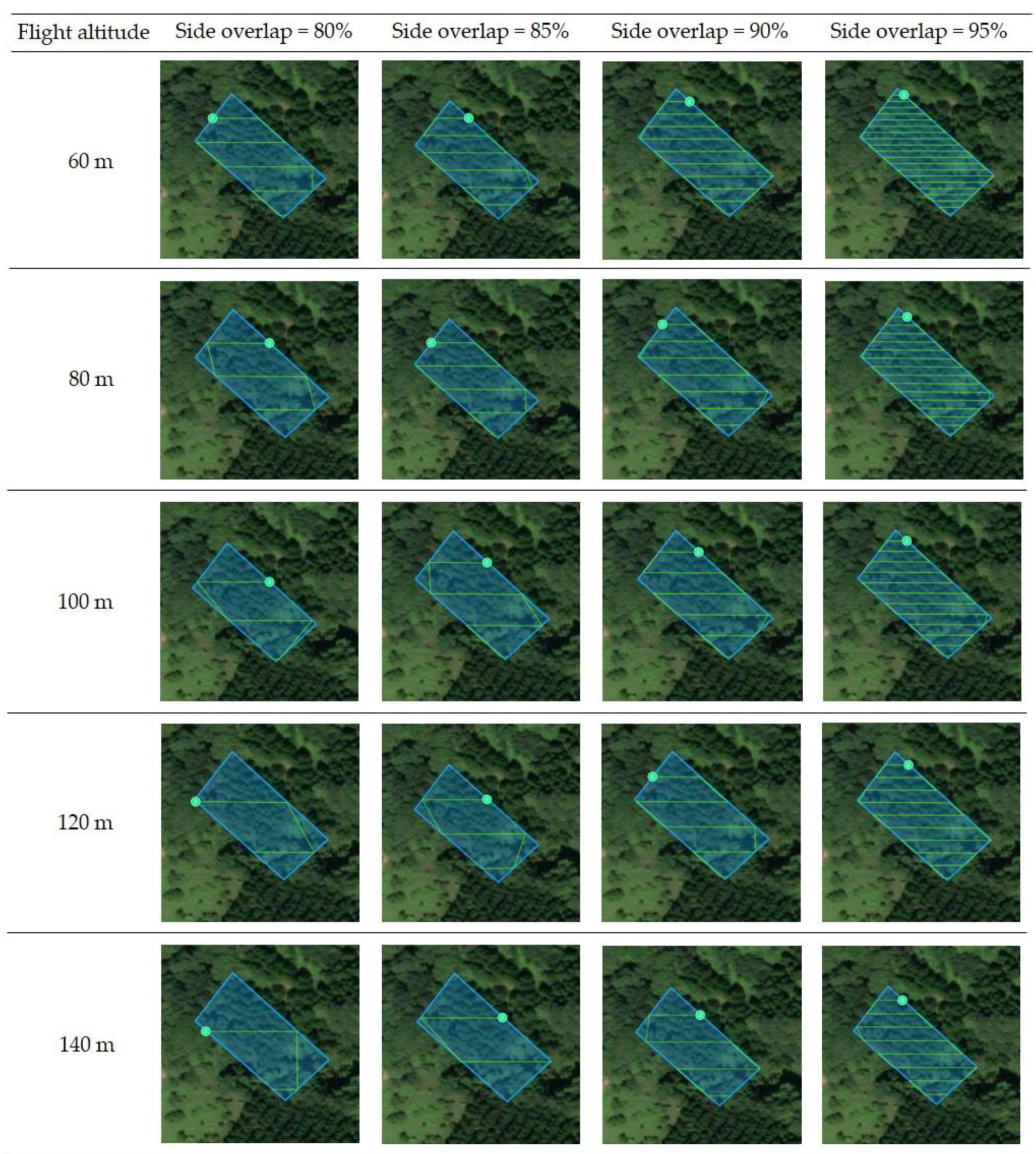
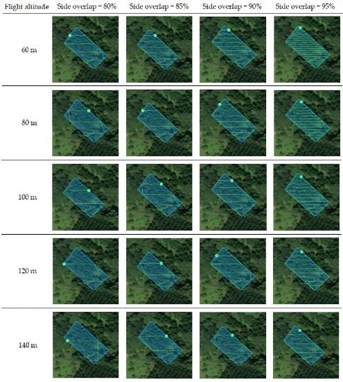
A total of 80 flight conditions were used, wherein five flight altitudes, four different degrees of overlap, and four different degrees of side overlap were combined (Table 2). There is a relationship of base to height ratio (B/H) between flight altitude and overlap (photography interval) (Table 3). The bigger the value of B/H, the more exaggerated the SfM processing. Images acquired on multiple flight paths are required for SfM processing. Therefore, the flight path was set oblique to the rectangular target area in order to increase the number of flight paths of the target area with a small area (Figure 3). In addition, the arrangement of trees in the survey site planted at the time of shooting was irregular. The flight altitude and side overlap determine the flight path. Therefore, the 20 flight paths in this study are shown in Figure 3. However, it is possible to set multiple flight paths under one flight condition (for example, right angle or oblique to the survey site). The flight paths setting affects the number of shots. However, this study is to examine the effects of flight altitude, overlap, and side overlap. Therefore, we do not consider changing the flight paths. In addition, the flight paths are carried out with the default value of the application.
We used the DJI GS PRO to set these flight conditions and operate the UAV. Aerial photography was performed via the automatic flight setting with DJI GS PRO. However, as takeoff and landing were performed from a logging road, there was a possibility of collision with trees and crashing during ascent and descent. Therefore, operation from takeoff to the start of automatic flight and from the end of automatic flight to landing were performed manually by an operator.

2.3. Processing of Aerial Images and Measurements/Estimate Methods

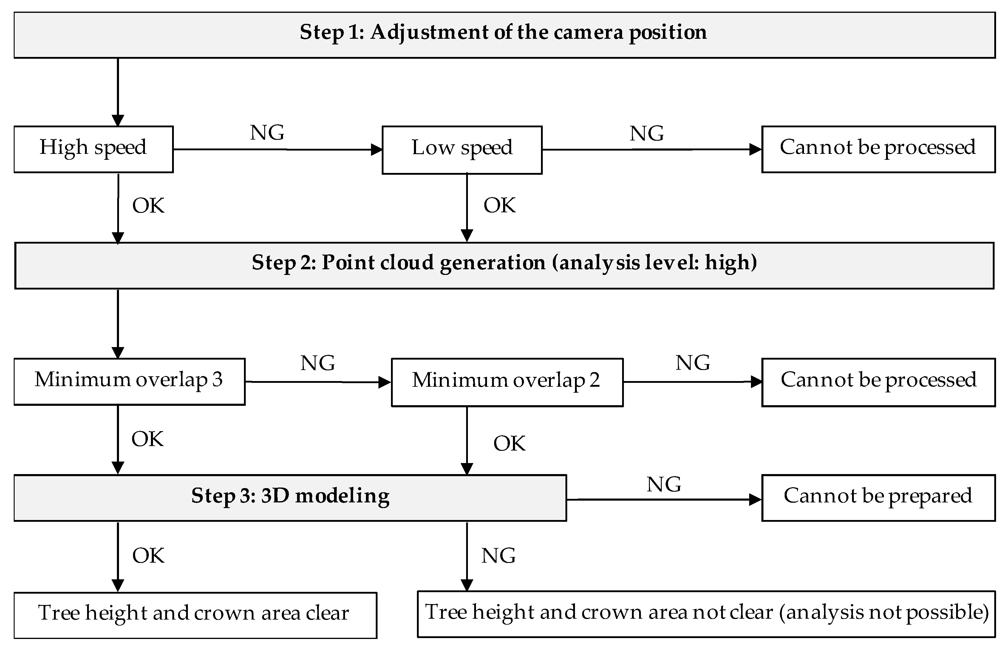
Terra Mapper was used for SfM analysis. The specifications of the computer used are as follows: Windows 10 Home, 64 bytes with 32 GB memory, and an Intel Core i7-7700HQ processor. Processing of aerial images was performed according to the manual after uploading aerial images to Terra Mapper. The procedure was as follows: Step (1) adjustment of the camera position (flight altitude was entered, the “high speed” mode was selected, and if this could not be processed, then the “low speed” mode was selected); Step (2) generation of the point cloud (the point cloud level was set as “high” and the minimum number of overlaps was set as “3”; if this could not be processed, the minimum number of overlaps was changed to “2”); and Step (3) 3D modeling (Figure 4). In Step 1, the most important aspect is the processing speed. The Terra Mapper manual recommends that a “high speed” mode is used when the data volume is large and that a “low speed” mode is used when the shooting site is long and the side overlap is small [28]. The most significant factor for Step 2 is the number of laps required for point cloud generation. When the minimum number of overlaps is “3”, no point cloud is created for the point with two laps. The manual recommends that a minimum number of overlaps “3” is used [28]. However, if the minimum number of overlaps is “3” and it cannot be performed, it will be performed with “2”. Furthermore, the process NG (incomplete) in Steps 1 and 2 is when an error is displayed in the software.
Under flight conditions in which Step 3 (3D modeling) was able to render the images properly and provide complete and satisfactory outputs, we prepared the DSM and orthographic images. For flight conditions where 3D modeling of the majority or part of the survey site was insufficient, we did not take any further measurements or perform verification for accuracy.
Measurements and estimates with the UAV were performed based on the prepared 3D model, DSM images, and orthographic images. Measurements of tree height and crown area were performed using Terra Mapper. For tree height, we used the Z value of point cloud data from Terra Mapper. Furthermore, we used the area calculation function of Terra Mapper to determine the measured value for the area of the crown. To estimate the volume, we obtained a correlation formula from the crown area measured with the UAV and the actual measurements of diameters at breast height according to the method described by the Ministry of Agriculture, Forestry and Fisheries [31]. We then estimated DBH and volume from the tree height measured with the UAV.

2.4. Verification of Accuracy of Measured and Estimated Values

We used the standard deviation (SD) to examine variations in the values measured and estimated with the UAV. In case true values (actual values) were obtained from the tree survey, the difference, i.e., root mean square error (RMSE) and relative root mean square error (RMSE%), between the values measured and estimated with the UAV and the actual values was used [7,12]. The equations are as follows:
RMSE = i = 1 n ( y i y ´ i ) 2 n  
RMSE [ % ] = R M S E y ¯ * 100
where n is the total number or samples, y i is the predicted values, y ´ i is the observed values, and y ¯ is the mean of n observed values.
A Kolmogorov–Smirnov goodness of fit test was performed to determine whether data were normally distributed. The statistical difference was determined by a two-sided paired t test. A difference with p < 0.05 was considered significant. These statistical analyses were performed using Reviewer by the Data Science Institute, Japan.

3. Results

3.1. Aerial Images and Their Clarity

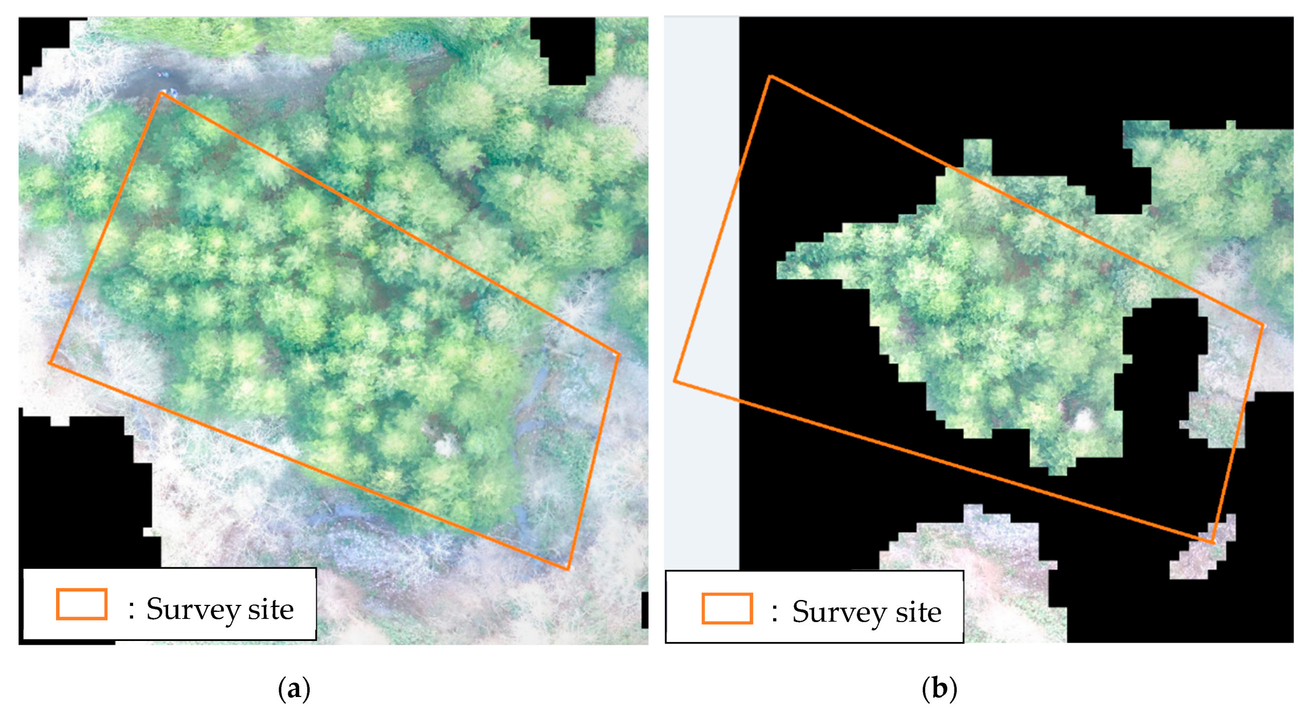
In Step 1 (i.e., the adjustment of the camera position for the 80 flight conditions), we processed images with the “high speed” mode for 36 conditions and the “low speed” mode for 44. In Step 2 (point cloud generation), we processed 48 flight conditions with the minimum number of overlaps being “3” and 32 flight conditions with “2”. In Steps 1 and 2, there were no flight conditions that made processing impossible. Step 3 (3D modeling) was possible under all flight conditions and aerial images could be processed under all conditions. Under 64 flight conditions, we were able to read the tree height and crown area from the 3D model (Figure 5a). Under the remaining 16 flight conditions (Table 4), 3D modeling was incomplete, and tree height and crown area could not be read for any of the trees (Figure 5b).
For flight conditions where processed aerial images could not be read, many flight conditions had degrees of overlap and side overlap of 80% and 85%, respectively. When the camera position was set to “low speed” and the minimum number of overlaps for the point cloud generation was “2”, the reading of tree height and crown area was often impossible. In contrast, when the camera position was set at “high speed” and the minimum number of overlaps for the point cloud generation was set at “3”, the tree height and area of crown could be read under all flight conditions.
The majority of the survey area was incomplete because of an insufficient degree of overlap in the photographs, thereby making analysis insufficient. In the preparation of the DSM, points may be missing owing to wind and shadow [5]. Light conditions are also an important factor that may have caused a certain amount of error [32]. Imagery quality is strongly impacted by variation in illumination due to season, weather, and shading [13]. Therefore, there might have been an effect from wind-shaken treetops and sunlight causing insufficient SfM processing for part of the survey site. Additionally, SfM requires the overlapping of nine or more images, and missing parts may increase due to a lack of images [20]. In this study, the study area was small, and the number of pictures taken were less, resulting in insufficient 3D modeling with gaps.
Flight conditions with normal 3D modeling included conditions that had an overlap and side overlap of 80% and 85%, respectively. However, considering that processing could be insufficient, and UAV aerial imaging need to be performed again in the field, overlap and side overlap should have a high degree of overlap in photography, i.e., 90% or higher.

3.2. Crown Area Measurement

Figure 6 shows the measurement results of crown area for each tree, and the SD from 64 flight conditions for which tree height and crown measurements were clear. The SD for each tree ranged from 0.08 to 0.68 m2. Forty-eight trees had an SD of either 0.08–0.2 m2 or 0.2–0.32 m2 accounting for more than half of the sampled trees. Trees with higher SD were found near the edge of the forest, and the SD was lower in areas where the tree stand was dense or away from the edge. The actual value of the crown area was not measured. The comparison of UAV measurement values shows that even if measurements were taken under different flight conditions, when image processing and measurements were possible, the error in the measured values among trees was small.
Based on the density of trees from the survey, this was a relatively sparse stand. As the actual area of the crown was not obtained, we are unable to make a comparison; however, measurement values for the crown area in the present survey may be overestimated. Orthographic images after SfM processing indicated that the edges of the forest experienced a larger overestimation. Overestimation around the edge of the forest may be a common problem and not limited to the present survey site. The present survey site utilized the area calculation function of Terra Mapper and identified the area in order to measure the crown area; however, such a calculation is difficult in dense stands and measurement results may be underestimated.

3.3. Tree Height

The normality of the measured and measured values of tree height was calculated using a Kolmogorov–Smirnov goodness of fit test (P > 0.05). Normality was confirmed under all flight conditions (Table 5). Statistical differences were confirmed by two-sided paired t tests. As a result, a significant difference was observed in all cases (P < 0.05) (Table 6).
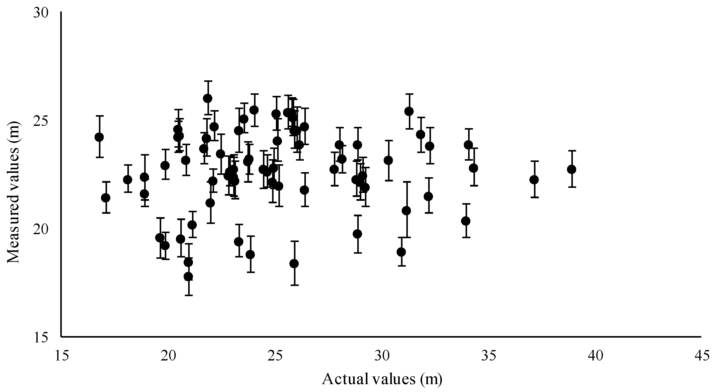
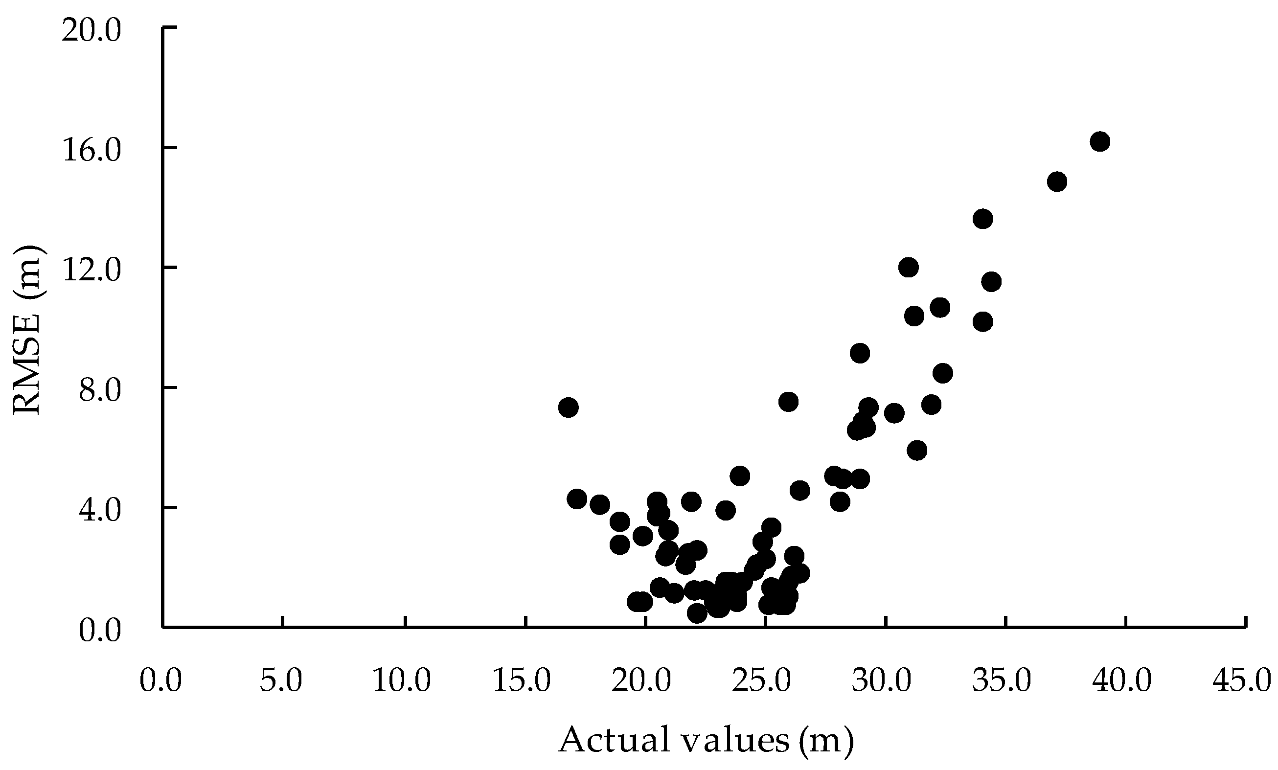
Figure 7 shows the comparison of mean tree height calculated using the UAV for each tree under different flight conditions, as well as the actual tree heights. Figure 8 shows the comparison of the RMSE of target trees calculated using the UAV for each tree under different flight conditions and the actual tree heights. The SD of tree height measured with the UAV for each tree (Figure 7) ranged between 0.5 and 1.2 m. Therefore, the effect of different flight conditions on errors in tree height measurement for each tree was negligible. In addition, tree height measured with the UAV tended to be lower than the actual values. Measured tree heights in the present study were underestimated; however, analysis with the SfM analytical software, PhotoScan Professional (Agisoft), tended to overestimate tree height [2,4]. Thus, our results were inconsistent with previous studies. The RMSE for each tree (Figure 8) ranged between 0.54 (2%) and 16.22 m (77%). For 47 trees, the RMSE% was 5% or lower. The relationship between the RMSE and the actual values is that most of the target trees have a RMSE of 4 m or less, when the actual value is about 26 m or less. Therefore, the accuracy of the target tree up to around 26 m was relatively good. However, when the actual value exceeds 26 m, the RMSE value tends to increase (representing decreased accuracy). The higher the tree height, the more remarkable the decrease in accuracy. Measurement error is likely because the UAV-measured values under all flight conditions were underestimated compared to the actual values.
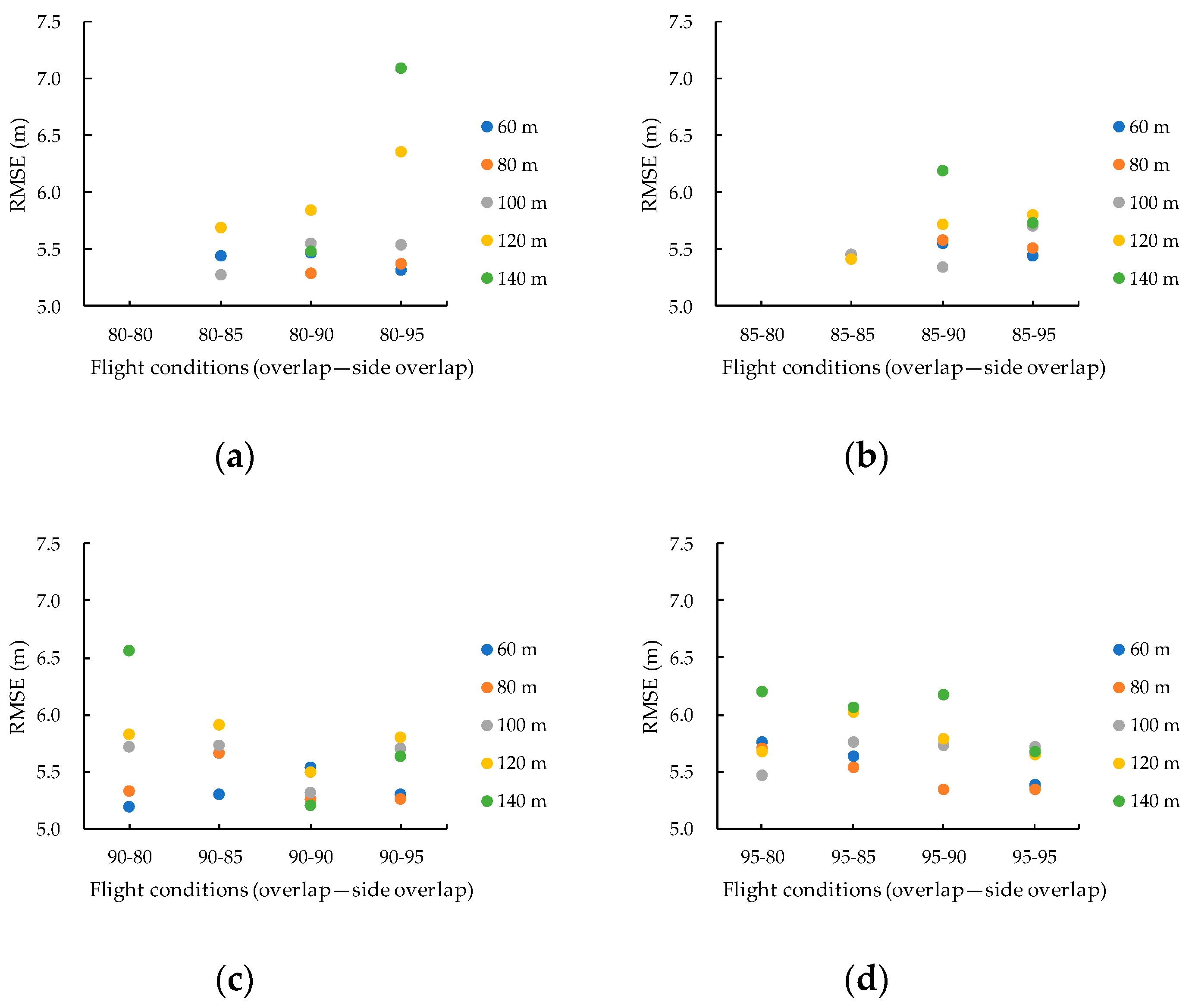
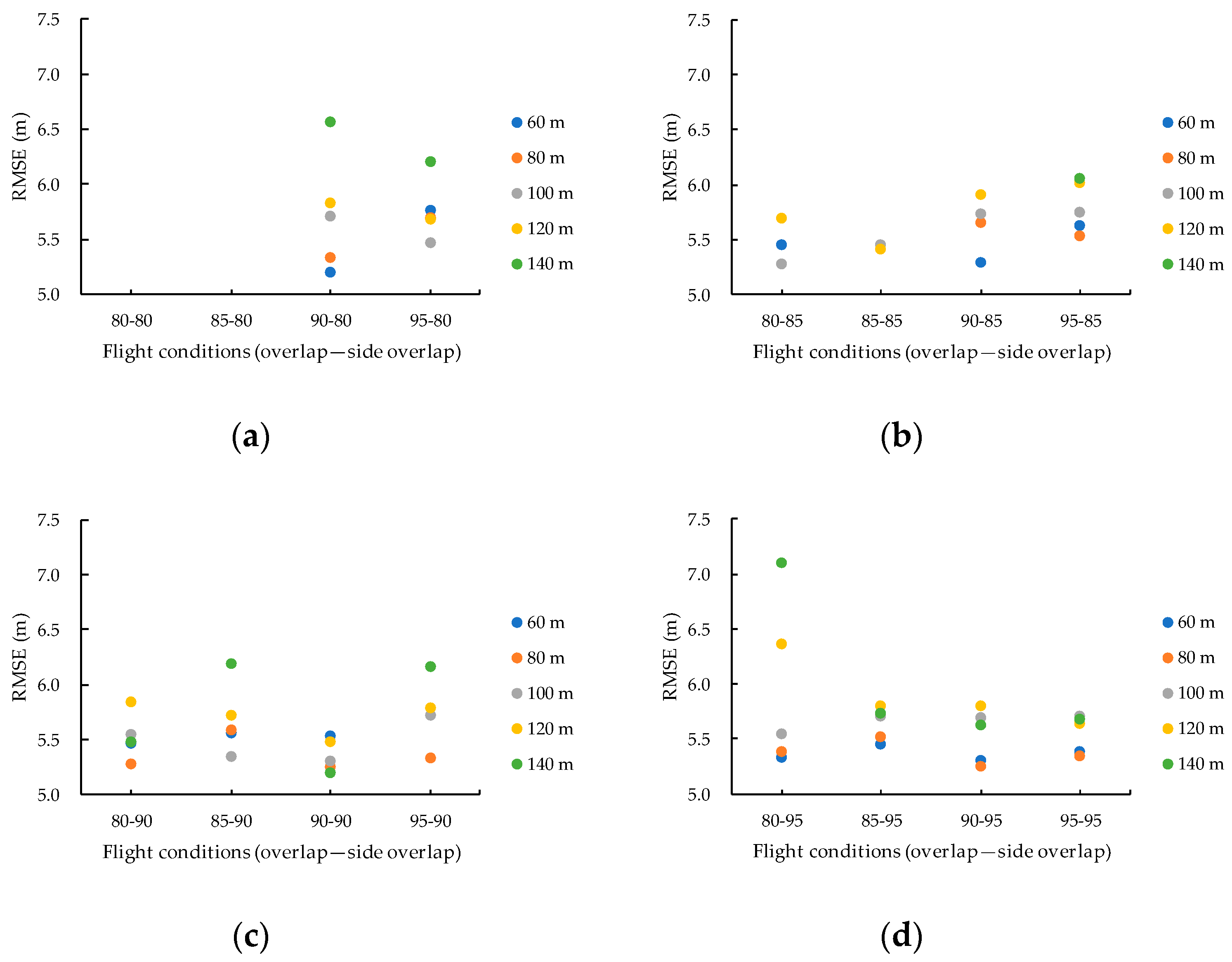
Figure 9 shows the RMSE for the measured results of tree height under different flight conditions (flight altitude); Figure 10 and Figure 11 show the RMSE for the measurement results of tree height for each flight condition (overlap and side overlap, respectively). RMSE ranged from 5.2 (21.9%) to 7.1 m (34.8%). The RMSE at a flight altitude of 60 m was between 5.20 (21.9%) and 5.76 m (25.7%); at a flight altitude of 80 m it was between 5.26 (22.3%) and 5.7 m (25.3%); at 100 m it was from 5.28 (22.5%) to 5.67 m (25.9%); at 120 m it was from 5.42 (23.3%) to 6.36 m (30.0%); and the RMSE at a flight altitude of 140 m was between 5.21 (21.8%) and 7.1 m (34.8%). According to Figure 10 and Figure 11, there is no tendency to improve the measurement accuracy, even if the degree of overlap in photography (overlap and side overlap) of the photographs is increased. However, increasing both the overlap and the side overlap tends to reduce the possibility that measurement due to loss of the 3D model becomes impossible. The present result shows that flight conditions with good RMSE and accurate tree height tended to have a low flight altitude. Under all flight conditions, measurement accuracy was 20% or more, but since variation in RMSE was small in low flight altitude conditions, the difference in flight conditions had little effect on errors in the measurements of tree height. Therefore, it is shown from the tree height measurement results that flight altitude has a large effect on measurement accuracy, and the degree of overlap in photography has a large effect on SfM processing. It is necessary for the flight altitude to be low and the degree of overlap in photography to be high.
In this study, the analytical software methodology used resulted in small variations in the measured values of tree height calculated for each tree under different flight conditions; however, compared to actual values, accuracy was low and the errors were large. It can be suggested that accuracy was low because there was also a significant difference in the results of the two-sided paired t tests. The results show that the accuracy for tree height for any of the flight conditions was low.

3.4. Tree Volume

The relationship coefficient between canopy area and DBH was between R2 = 0.21 and 0.63. A positive correlation was observed in many flight conditions. The normality of the estimated and measured values of the volume was confirmed by a Kolmogorov–Smirnov goodness of fit test (P > 0.05). Normality was confirmed under all flight conditions (Table 7). Statistical differences were confirmed by two-sided paired t tests. Significant differences were found under many conditions (P < 0.05) (Table 8).
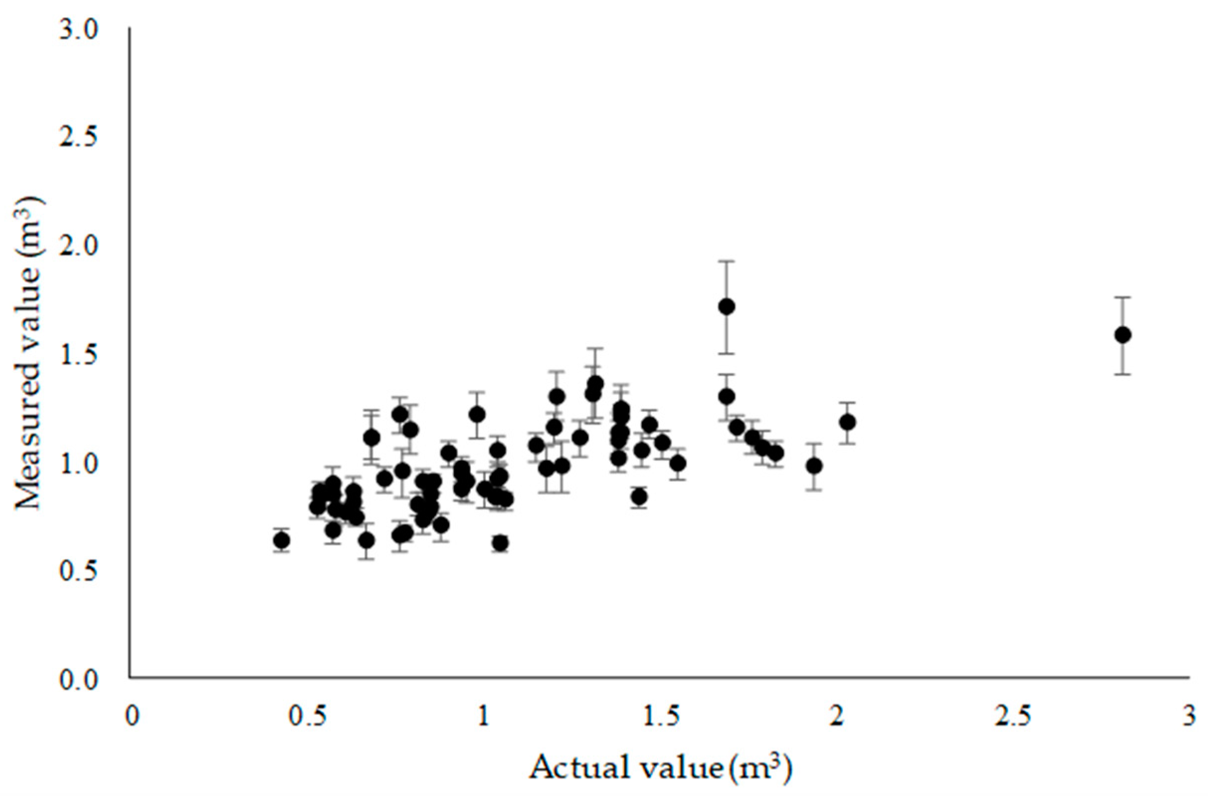
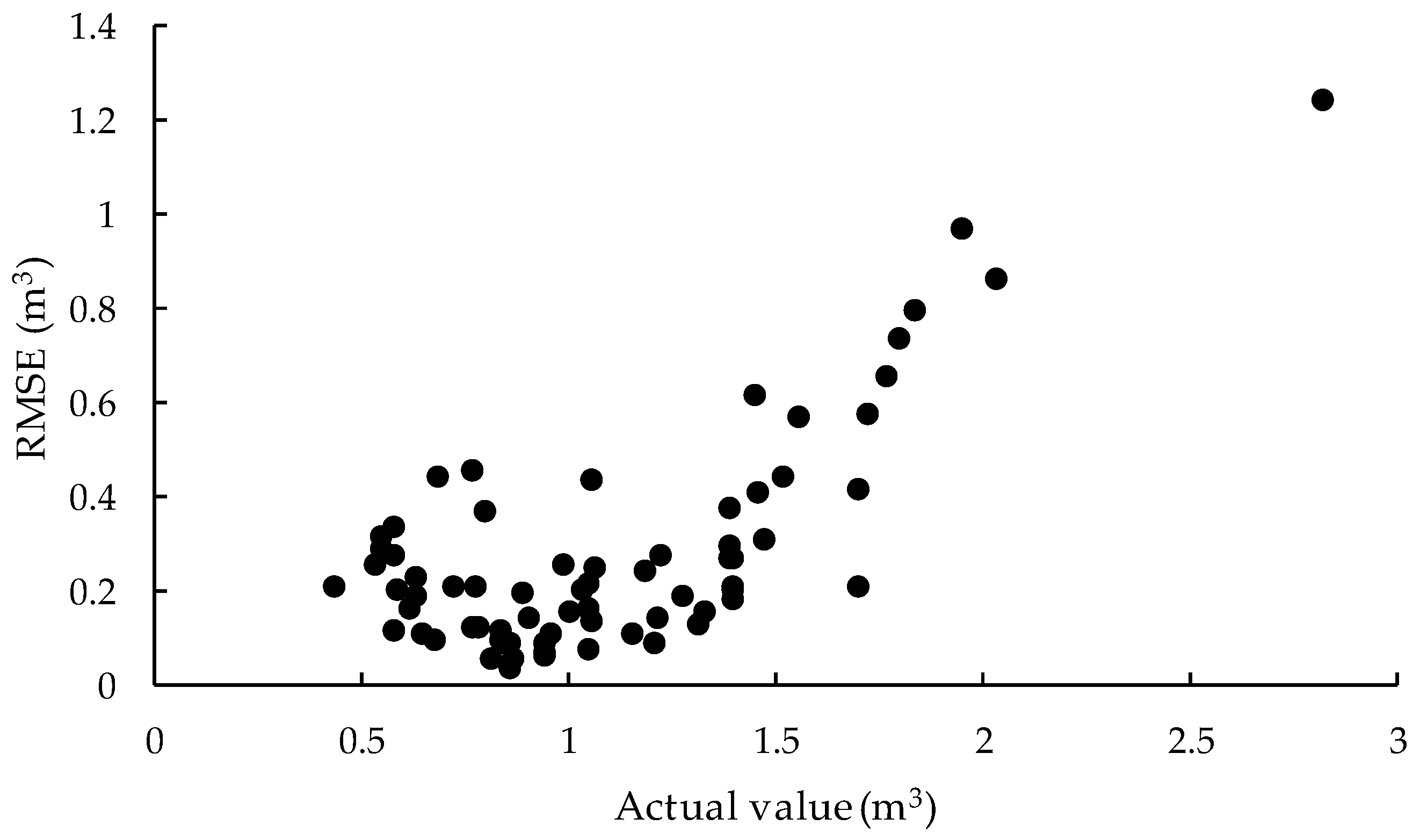
Figure 12 provides a comparison between the mean volume estimated from UAV measurements for each tree under different flight conditions and the actual values. Figure 13 shows the relationship between volume and RMSE for each target tree. The SD for each tree ranged between 0.04 and 0.21 m3. Volumes estimated from UAV measurements were underestimated compared to the actual volumes. The RMSE for each tree volume ranged between 0.04 (5%) and 1.94 m3 (99%). Only 32 trees had a RMSE of 0.2% or less (RMSE% = 20%). Ten trees with RMSE% = 50% or more were found. In addition, most of the target trees with an actual measurement value of 1.5 m3 or less had a RMSE = 0.2 m3 (RMSE% = 20%) or less. However, the RMSE value was extremely degraded when the measured tree was 1.5 mm or more. The reason for the loss of accuracy is related to the underestimation of tree height, as discussed in Section 3.3.
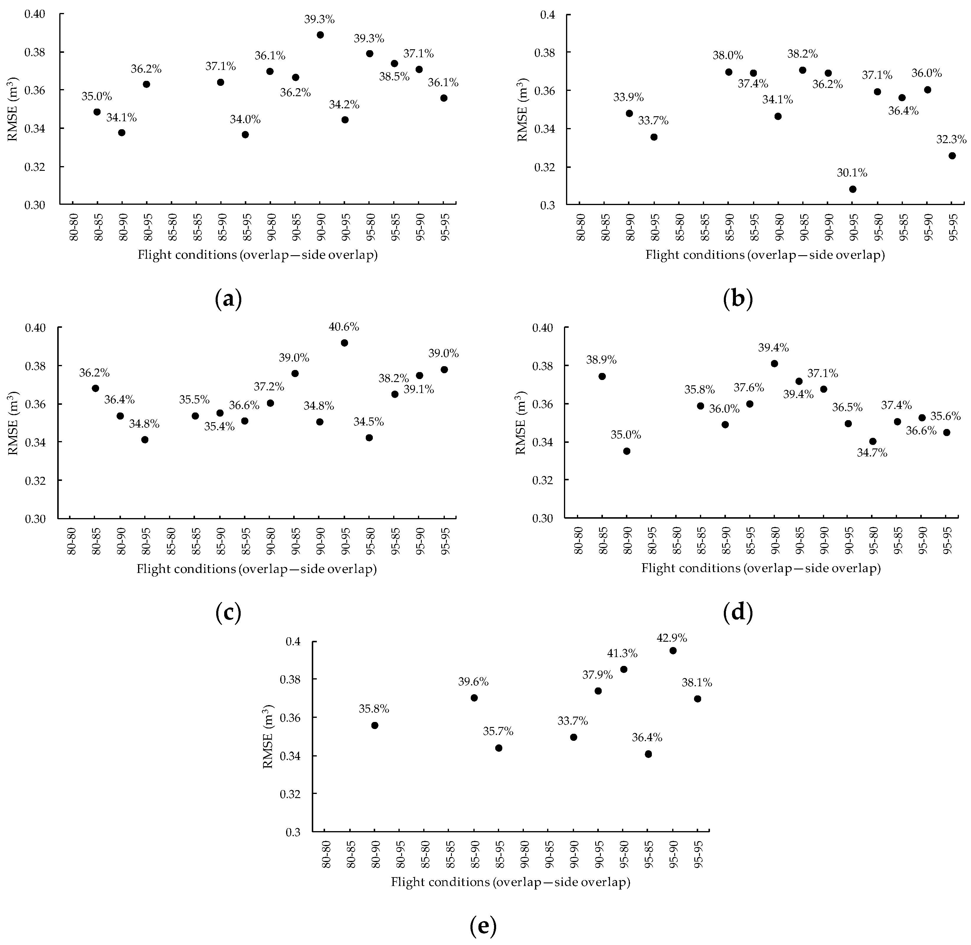
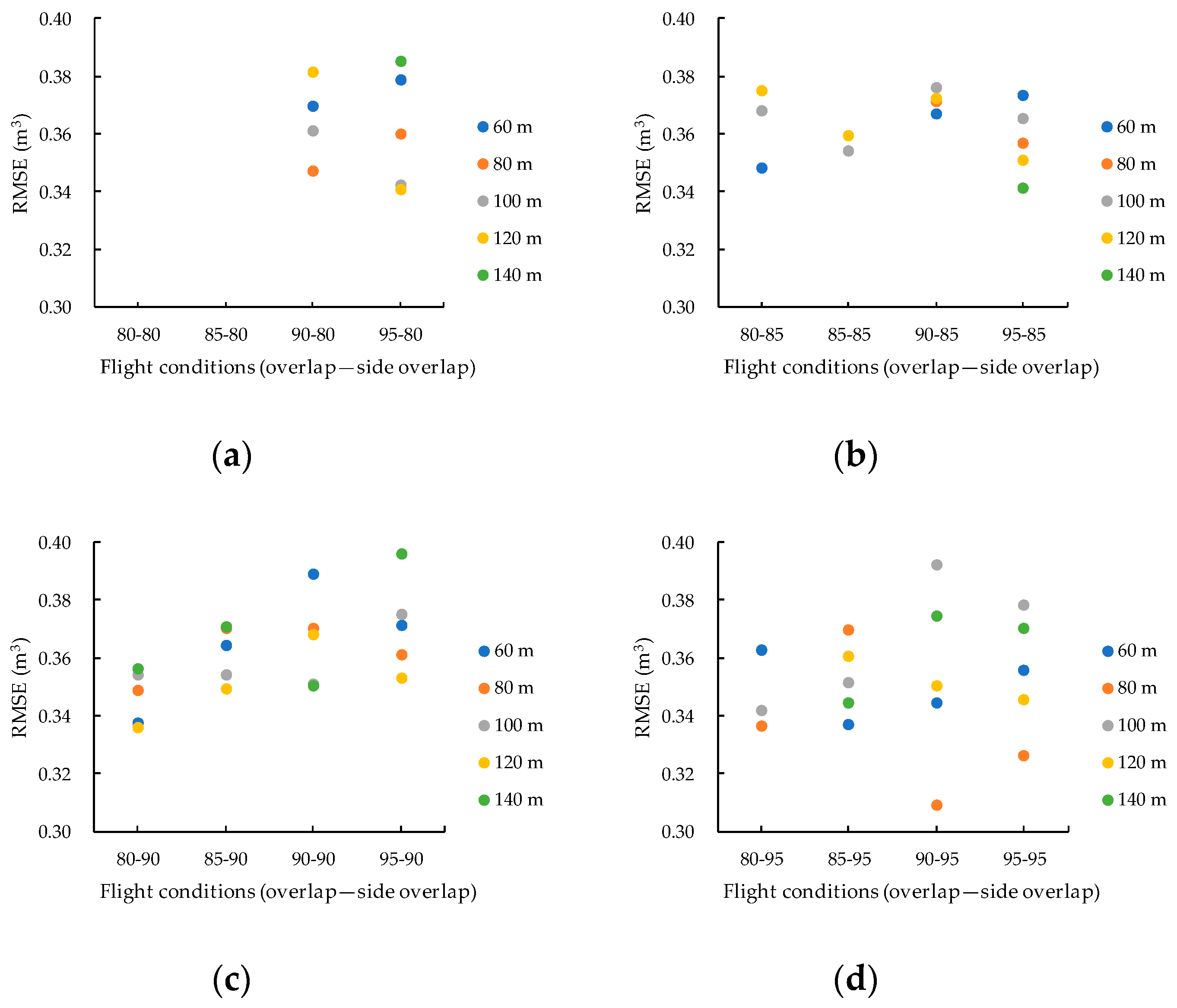
Figure 14 shows the RMSE values of tree volumes estimated under different flight conditions (flight altitude); Figure 15 and Figure 16 show the RMSE of tree volume measurement results for each flight condition (overlap and side overlap, respectively). The RMSE ranged between 0.31 and 0.4 m3. The lowest RMSE was 0.31 m3 and RMSE% was 30.1%. The most common values for RMSE were within 0.34 and 0.376 m3. In Figure 14, there is no remarkable difference between the estimated results due to the change in flight altitude and the results of the volume at each flight altitude. Therefore, while it is necessary to improve accuracy, differences in flight altitude have little effect on the accuracy of volume estimations. As shown in Figure 15 and Figure 16, the influence of the overlap and the side overlap was not so significant that a higher degree of overlap in photography of the image resulted in better accuracy. Therefore, there is no effect of altitude when measuring volume from the measurement result of the volume. However, it is necessary to set the flight altitude low when the measurement results of tree height are relatively good. In addition, the degree of overlap in photography has little effect on measurement accuracy in terms of the measurement results of the tree height. However, considering that SfM processing is insufficient, a high degree of overlap in photography is required. Accuracy of volume for each flight condition was mostly 30% or more, but variation in the RMSE was small. Similar to the result obtained for each tree height, estimates for volume might have been underestimated because the accuracy of tree height measurement was low.
When estimating tree volume under different flight conditions, variations in the estimated values for each tree were small; thus, estimates with relatively small variation were possible. In addition, the results of the two-sided paired t-tests also showed significant differences under many conditions, indicating that accuracy was low. However, when compared to the actual values, the error became larger. Variations in estimated values were also small for each flight condition, but since measured values did not seem reasonable, it is necessary to improve measurement accuracy for tree height and the accuracy of the estimated values.

3.5. Analyzing Comprehensive Results

The present study verified the accuracy of the measured values and those estimated through different aerial photography methods and flight conditions. The results show that, based on the ability to process images, the overlap and side overlap of photographs need to be 90% or higher when taking measurements in forests. Though there is little effect from flight altitude on image processing when taking measurements in forests, the terrain of the takeoff site, landing site, and flight area need to be taken into consideration when setting the flight altitude. The verification of accuracy showed that when image processing, 3D modeling, DSM imaging, and orthographic imaging provided complete and satisfactory outputs, irrespective of flight conditions for UAV measurements, the accuracy was low with respect to the actual values. However, the measured values were stable at low flight altitudes. In processing and measuring the aerial images, analysis with SfM processing becomes more unstable as the degree of overlap in photography decreases. Reduced accuracy could cause errors in measured values. However, when the degree of overlap in photography (overlap and side overlap) was changed and the measured and estimated values were compared, there were errors, though the variation was small. Similar to the findings reported by Sugai et al. [33], there was a noticeable difference in accuracy as a result of changing the degree of overlap in the photography. For this reason, we consider the flight altitude to have a considerable influence on the accuracy of measurement, and that the degree of overlap in photography (overlap and side overlap) has a substantial effect on SfM processing. Moreover, previous studies have recommended that the flight altitude should be low [24] and that the required degree of overlap for photography should be high [23,24,25], indicating similar tendencies to those found in this study.

3.6. Points to Note Regarding UAV Use

The following points describe factors and issues that contributed to the poor accuracy found in this study: (1) the survey and flight was performed in a small area, (2) measurements were made using SfM processing software, and (3) there were no GCPs (ground control points). Each of these is described in detail below.
In the present study, we entered the numerical values for flight conditions (flight altitude, overlap, and side overlap) into DJI GS PRO for automatic UAV flight and aerial photography. Values for flight altitude input were the flight altitudes measured from the takeoff site of the UAV. However, flight altitude in the aerial photography areas is measured as the height above ground level. Therefore, there could be discrepancies in height depending on the differences between flight altitude and height above ground level. As input values and actual flight altitudes were different, the degree of overlap in photography (overlap and side overlap) might be insufficient. We believe this is possible for any UAV or flight application. However, in the case of a small area, since the number of images is small, the influence of image loss leads to a large error. When the number of images is large, it is considered that other images can be used to compensate for some loss. Therefore, a lot of care must be taken while flying, especially in small areas.
In the case of manual operation and photography, it is difficult to determine overlap and side overlap, which increases the difficulty in photography and flight. The advantages of using UAV include low cost, high resolution, high-density data, as well as versatility, safety, and flexibility in shooting [34,35,36,37]. For example, if simple photographs are to be taken over a wide area to understand damage from landslides, a manual flight with more freedom might be more effective than an automated flight. However, when conducting a detailed survey in which a 3D model is created using SfM technology, it would be essential to use automated flight and photography by identifying the condition of the survey site, considering the advantages of a UAV flight. Additionally, there is a risk of crashing in bad weather [1,38]. Therefore, even in an automatic flight or a manual flight with SfM processing, it is recommended to stop or change the flight plan, depending on the weather. Users need to understand the characteristics of the survey site, the UAV used, and the flight application in order to operate the equipment properly.
In this study, the measurements of tree height and crown area were performed using analysis software. No other case of measurements made using analysis software, as was done in this study, are known. Regarding the processing of aerial images, when using a multicopter-style UAV, the trend differed with each software program [39,40], indicating that the algorithm of the SfM software has not been disclosed [33]. Moreover, the UAV Stand Inventory Manual points out that there is little knowledge regarding analysis technology [1]. When performing a forest survey, such as for tree height using a UAV, the use of SfM software becomes essential, and there are several choices ranging from free to expensive software. It is difficult to understand the measurement algorithms of all the software; however, it is important to recognize that SfM software tends to be highly versatile with relatively high reliability. In this study, the influence of SfM software is also a factor in the low accuracy generated. Therefore, analysis using other SfM software and verification is also necessary, and is a subject for future research.
Many UAV-based surveys and research projects have GCPs set up. However, this study did not use this method. Iizuka et al. [9] also did not use GCPs, but the RMSE of the tree height was 1.712 m and the accuracy was high. As a result, a roughly accurate measurement was performed, indicating a different tendency. The installation of GCPs requires precise surveying and the addition of highly accurate location information [1]. Additionally, even if GCPs are installed, there is a possibility that the antiaircraft sign may not be recognized owing to the influence of the upper tree [1,9]. For this reason, installation requires labor, and a wide gap is required in the sky. Users need to determine whether GCPs are installed and how many GCPs should be used. This will depend on the purpose of use and whether it is better to perform accurate measurements or to collect simple information, such as forest monitoring and 3D model creation.

4. Conclusions

This study aimed to investigate the effects of differences in shooting and flight conditions for UAV on the processing method and estimated results of aerial images. Forest images were acquired under 80 different conditions, combining various aerial photography methods and flight conditions. We verified errors in values measured by the UAV and the measurement accuracy with respect to tree height and volume. However, irrespective of flight conditions for UAV measurements, accuracy was low with respect to the actual values. In the present study, we selected a flat survey site to minimize the effect of the terrain. Therefore, the data we collected are insufficient for an examination of the effects of microtopography and slopes. Moreover, the UAV Stand Inventory Manual prepared by the Ministry of Agriculture, Forestry and Fisheries [1] is currently limited to forests with a uniform forest type. As there are still many challenges and limitations in forest measurement using UAV, set investigation of various flight conditions is required. In the future, we will proceed with studies to address the factors and solve the issues that caused the deterioration in accuracy encountered in this research. The accumulation of data on the settings of flight conditions for aerial photography is necessary to improve accuracy when measurements are taken on a slope.

Author Contributions

Conceptualization, S.K.; formal analysis, S.K.; investigation, S.K.; methodology, S.K.; writing—original draft, S.K. and K.S.; writing—review and editing, S.K. and K.S. All authors have read and agreed to the published version of the manuscript.

Funding

Part of this research was supported by a large research grant from the College of Bioresource Sciences, Nihon University from fiscal year 2016 to fiscal year 2018.

Conflicts of Interest

The authors declare no conflict of interest.

References

  1. Ministry of Agriculture, Forestry and Fisheries. The 2018 “Commissioned Project to Build a System to Improve Efficiency of Methods Such as Harvest Survey in National Forests” UAV Stand Inventory Manual. Available online: http://www.rinya.maff.go.jp/j/gyoumu/gijutu/attach/pdf/syuukaku_kourituka-2.pdf (accessed on 17 September 2019).
  2. Kobayashi, H. Automated aerial shooting, counting tree numbers and measuring tree heights for Sugi stands with a UAV. Chubu For. Res. 2019, 67, 57–60. [Google Scholar]
  3. Yada, Y.; Kimura, K.; Atsumi, K.; Aoki, M.; Yamaji, K.; Kawasaki, M.; Shirai, N.; Mitani, N. Estimation of stand volume using UAV in Ishikawa Prefecture’s Sugi plantation forest: Validation of 2017 version volume estimation model. Chubu For. Res. 2018, 66, 81–82. [Google Scholar]
  4. Arita, T.; Hirose, Y.; Numamoto, S.; Matsumura, N.; Shimada, H.; Nomura, H. Precision inspection of the latest measuring instrument for practical use and acquisition of forest information resources. Chubu For. Res. 2018, 66, 77–80. [Google Scholar]
  5. Asaka, T.; Aoyama, S.; Iwashita, K.; Kudo, K.; Fujii, H. A height measurement method for coastal forests using aerial photos taken with a small unmanned airborne vehicle. J. Jpn. Soc. Coastal For. 2010, 9, 91–96. [Google Scholar]
  6. Tamura, T.; Kato, A.; Obanawa, H.; Yoshida, T. Tree height measurement from aerial images taken by a small unmanned aerial vehicle and structure from motion. J. Jpn. Soc. Reveg. Technol. 2015, 41, 163–168. [Google Scholar] [CrossRef] [Green Version]
  7. Krause, S.; Sanders, T.G.M.; Mund, J.; Greve, K. UAV-Based Photogrammetric Tree Height Measurement for Intensive Forest Monitoring. Remote Sens. 2019, 11, 758. [Google Scholar] [CrossRef] [Green Version]
  8. Swinfield, T.; Lindsell, J.A.; Williams, J.V.; Harrison, R.D.; Agustiono, H.; Gemita, E.; Schönlieb, E.G.; Coomes, D.A. Accurate Measurement of Tropical Forest Canopy Heights and Aboveground Carbon Using Structure From Motion. Remote Sens. 2019, 11, 928. [Google Scholar] [CrossRef] [Green Version]
  9. Iizuka, K.; Yonehara, T.; Itoh, M.; Kosugi, Y. Estimating Tree Height and Diameter at Breast Height (DBH) from Digital Surface Models and Orthophotos Obtained with an Unmanned Aerial System for a Japanese Cypress (Chamaecyparis obtusa) Forest. Remote Sens. 2018, 10, 13. [Google Scholar] [CrossRef] [Green Version]
  10. Birdal, A.C.; Avdan, U.; Turk, T. Estimating tree heights with images from an unmanned aerial vehicle. Geomat. Nat. Hazards Risk 2017, 8, 1144–1156. [Google Scholar] [CrossRef] [Green Version]
  11. Panagiotidis, D.; Abdollahnejad, A.; Surový, P.; Chiteculo, V. Determining tree height and crown diameter from high-resolution UAV imagery. Int. J. Remote Sens. 2017, 38, 8–10. [Google Scholar] [CrossRef]
  12. Jayathunga, S.; Owari, T.; Tsuyuki, S. Evaluating the Performance of Photogrammetric Products Using Fixed-Wing UAV Imagery over a Mixed Conifer–Broadleaf Forest: Comparison with Airborne Laser Scanning. Remote Sens. 2018, 10, 187. [Google Scholar] [CrossRef] [Green Version]
  13. Bonnet, S.; Lisein, J.; Lejeune, P. Comparison of UAS photogrammetric products for tree detection and characterization of coniferous stands. Int. J. Remote Sens. 2017, 38, 5310–5337. [Google Scholar] [CrossRef]
  14. Warfield, A.D.; Leon, J.X. Estimating Mangrove Forest Volume Using Terrestrial Laser Scanning and UAV-Derived Structure-from-Motion. Drones 2019, 3, 32. [Google Scholar] [CrossRef] [Green Version]
  15. Gülci, S. The determination of some stand parameters using SfM-based spatial 3D point cloud in forestry studies: An analysis of data production in pure coniferous young forest stands. Environ. Monit. Assess. 2019, 191, 495. [Google Scholar] [CrossRef] [PubMed]
  16. Chen, S.; McDermid, G.J.; Castilla, G.; Linke, J. Measuring Vegetation Height in Linear Disturbances in the Boreal Forest with UAV Photogrammetry. Remote Sens. 2017, 9, 1257. [Google Scholar] [CrossRef] [Green Version]
  17. Sakai, K.; Yamamoto, R.; Hasegawa, K.; Izumi, T.; Matsuyama, H. Generation of a DSM of the forest crown generated by vertical + oblique stereo pair images taken by a small-sized UAV. J. Remote Sens. Soc. Jpn. 2016, 36, 388–397. [Google Scholar]
  18. Lin, J.; Wang, M.; Ma, M.; Lin, Y. Aboveground Tree Biomass Estimation of Sparse Subalpine Coniferous Forest with UAV Oblique Photography. Remote Sens. 2018, 10, 1849. [Google Scholar] [CrossRef] [Green Version]
  19. Huang, H.; He, S.; Chen, C. Leaf Abundance Affects Tree Height Estimation Derived from UAV Images. Forests 2019, 10, 931. [Google Scholar] [CrossRef] [Green Version]
  20. Teng, P.; Fukumaru, Y.; Zhang, Y.; Aono, M.; Shimizu, Y.; Hosoi, F.; Omasa, K. Accuracy Assessment in 3D Remote Sensing of Japanese Larch Tree using a Small UAV. Eco-Engineering 2018, 30, 1–6. [Google Scholar]
  21. Torres-Sánchez, J.; López-Granados, F.; Borra-Serrano, I.; Peña, J.M. Assessing UAV-collected image overlap influence on computation time and digital surface model accuracy in olive orchards. Precis. Agric. 2018, 19, 115–133. [Google Scholar] [CrossRef]
  22. Domingo, D.; Ørka, H.O.; Næsset, E.; Kachamba, D.; Gobakken, T. Effects of UAV Image Resolution, Camera Type, and Image Overlap on Accuracy of Biomass Predictions in a Tropical Woodland. Remote Sens. 2019, 11, 948. [Google Scholar] [CrossRef] [Green Version]
  23. Dandois, J.; Olano, M.; Ellis, E. Optimal Altitude, Overlap, and Weather Conditions for Computer Vision UAV Estimates of Forest Structure. Remote Sens. 2015, 7, 13895–13920. [Google Scholar] [CrossRef] [Green Version]
  24. Seifert, E.; Seifert, S.; Vogt, H.; Drew, D.; Aardt, J.V.; Kunneke, A.; Seifert, T. Influence of Drone Altitude, Image Overlap, and Optical Sensor Resolution on Multi-View Reconstruction of Forest Images. Remote Sens. 2019, 11, 1252. [Google Scholar] [CrossRef] [Green Version]
  25. Ni, W.; Sun, G.; Pang, Y.; Zhang, Z.; Liu, J.; Yang, A.; Wang, Y.; Zhang, D. Mapping Three-Dimensional Structures of Forest Canopy Using UAV Stereo Imagery: Evaluating Impacts of Forward Overlaps and Image Resolutions With LiDAR Data as Reference. IEEE J. Sel. Topics Appl. Earth Observ. Remote Sens. 2018, 11, 3578–3589. [Google Scholar] [CrossRef]
  26. DJI. Phantom3 Advanced User Manual (Japanese Version) V1.2. Available online: https://dl.djicdn.com/downloads/phantom_3/jp/Phantom_3_Advanced_User_Manual_v1.2_jp_160406.pdf (accessed on 17 November 2018).
  27. Ministry of Land, Infrastructure, Transport and Tourism. Guidelines for Safe Flight of Unmanned Aerial Vehicles (Drones, Radio-Controlled Vehicles, etc.). Available online: https://www.mlit.go.jp/common/001303818.pdf (accessed on 17 September 2019).
  28. Terra Mapper User Manual. Available online: https://drive.google.com/drive/folders/1s5oVb7JpCEomynYx6vLoYrI4CC15CLEx (accessed on 2 April 2020).
  29. Geospatial Information Authority of Japan. The manual for public survey using UAV (Proposed) March 2017 Version. Available online: https://www.gsi.go.jp/common/000186712.pdf (accessed on 7 October 2018).
  30. DJI GS PRO User Manual (Japanese Version) V2.0. Available online: https://dl.djicdn.com/downloads/groundstation_pro/JP/GS_Pro_User_Manual_v2.0_JP_201811.pdf (accessed on 17 November 2018).
  31. Ministry of Agriculture, Forestry and Fisheries. The 2014 Survey on Disaster Countermeasures In Watersheds and Mountainous Areas (A Study on Driftwood Countermeasures) Commissioned Project Report 3. Examination of Methods to Assess Landslide Prevention Function of Forests and Risk of Driftwood. Available online: http://www.maff.go.jp/j/budget/yosan_kansi/sikkou/tokutei_keihi/seika_h26/ippan/pdf/ippan263_03.pdf (accessed on 7 October 2018).
  32. Zhang, Y.; Wu, H.; Yang, W. Forests Growth Monitoring Based on Tree Canopy 3D Reconstruction Using UAV Aerial Photogrammetry. Forests 2019, 10, 1052. [Google Scholar] [CrossRef] [Green Version]
  33. Sugai, S.; Miyaji, K.; Nakamura, T.; Minami, H.; Tachibana, K. Accuracy verification of photogrammetry using UAV. J. Geospat. Info. Auth. Jpn. 2017, 129, 147–157. [Google Scholar]
  34. Obanawa, H.; Hayakawa, Y.; Gomez, Y. 3D Modelling of inaccessible areas using UAV-based aerial photography and structure from motion. Transact. Jpn. Geomorphol. Union 2014, 35, 283–294. [Google Scholar]
  35. Murakami, T. Forest Remote Sensing Using UAVs. J. Remote Sens. Soc. Jpn. 2018, 38, 258–265. [Google Scholar]
  36. Tang, L.; Shao, G. Drone Remote Sensing for Forestry Research and Practices. J. Forestry Res. 2015, 26, 791–797. [Google Scholar] [CrossRef]
  37. Paneque-Gálvez, J.; McCall, M.K.; Napoletano, B.M.; Wich, S.A.; Koh, L.P. Small Drones for Community-Based Forest Monitoring: An Assessment of Their Feasibility and Potential in Tropical Areas. Forests 2014, 5, 1481–1507. [Google Scholar] [CrossRef] [Green Version]
  38. Kameyama, S.; Yoshioka, T. UAV (Drone). J. For. Mech. Soc. 2019, 786, 34–36. [Google Scholar]
  39. Chikatsu, H.; Odaka, A.; Yanagi, H.; Yokoyama, H. Performance Evaluation of 3D Modeling Software for UAV Photogrammetry. J. Jpn. Soc. Photogram. Remote Sens. 2016, 55, 117–127. [Google Scholar]
  40. Kitagawa, E.; Muraki, H.; Yoshinaga, K.; Yamagishi, J.; Tsumura, Y. Research on Shape Characteristic of 3D Modeling Software (SfM/MVS) in UAV Aerial Images. J. Jpn. Soc. Civil Eng. 2018, 74, 143–148. [Google Scholar] [CrossRef]
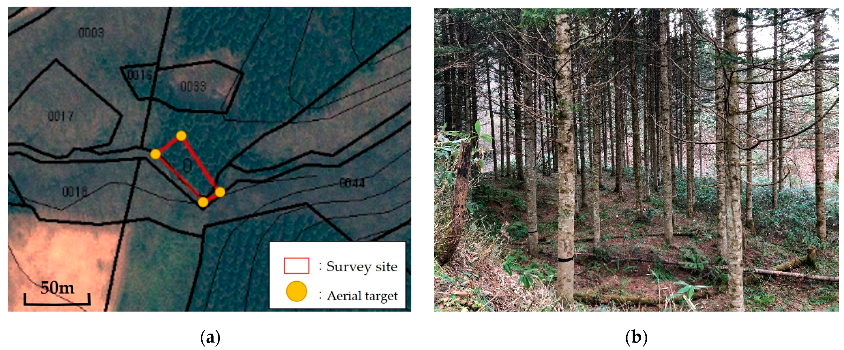
Figure 1. (a) Location of survey site, and (b) the general landscape of the survey site.
Drones 04 00019 g001
Figure 2. Phantom3 Advanced unmanned aerial vehicle (UAV, or drone).
Drones 04 00019 g002
Figure 3. UAV (unmanned aerial vehicle) flight path. Note: the green line represents the flight path.
Drones 04 00019 g003
Figure 4. Flowchart of UAV (unmanned aerial vehicle) aerial image processing using Terra Mapper software.
Drones 04 00019 g004
Figure 5. (a) 3D model where tree height and crown area were clear, and (b) 3D model where tree height and crown area were not clear.
Drones 04 00019 g005
Figure 6. SD (standard deviation) of measurement for the crown area of each target tree. Note: For the horizontal axis, ‘[’ means ≤, ‘]’ means ≥, and ‘(’ means <.
Drones 04 00019 g006
Figure 7. Comparison between mean tree height from UAV (unmanned aerial vehicle) measurement and actual tree height. Note: error bars indicate the SD (standard deviation).
Drones 04 00019 g007
Figure 8. Relationship between tree height and RMSE (root mean square error) of each target tree.
Drones 04 00019 g008
Figure 9. RMSE (root mean square error) and RMSE% (relative root mean square error) of tree height measurement results for each flight condition (flight altitude); (a) flight altitude = 60 m; (b) flight altitude = 80 m; (c) flight altitude = 100 m; (d) flight altitude = 120 m; and (e) flight altitude = 140 m.
Drones 04 00019 g009
Figure 10. RMSE (root mean square error) of tree height measurement results for each flight condition (overlap); (a) overlap = 80%; (b) overlap = 85%; (c) overlap = 90%; and (d) overlap = 95%.
Drones 04 00019 g010
Figure 11. RMSE (root mean square error) of tree height measurement results for each flight condition (side overlap) (a) side overlap = 80%; (b) side overlap = 85%; (c) side overlap = 90%; and (d) side overlap = 95%.
Drones 04 00019 g011
Figure 12. Comparison of mean estimated volume and actual volume of each target tree. Note: Error bars indicate the SD (standard deviation).
Drones 04 00019 g012
Figure 13. Relationship between volume and RMSE (root mean square error) of each target tree.
Drones 04 00019 g013
Figure 14. RMSE (root mean square error) and RMSE% (relative root mean square error) of tree volume measurement results for each flight condition (flight altitude) (a) flight altitude = 60 m; (b) flight altitude = 80 m; (c) flight altitude = 100 m; (d) flight altitude = 120 m; and (e) flight altitude = 140 m.
Drones 04 00019 g014
Figure 15. RMSE (root mean square error) of volume measurement results for each flight condition (overlap) (a) overlap = 80%; (b) overlap = 85%; (c) overlap = 90%; and (d) overlap = 95%.
Drones 04 00019 g015
Figure 16. RMSE (root mean square error) of volume measurement results for each flight condition (side overlap) (a) side overlap = 80%; (b) side overlap = 85%; (c) side overlap = 90%; and (d) side overlap = 95%.
Drones 04 00019 g016
Table 1. Specifications of the Phantom3 Advanced and the camera.
Model NamePhantom3 Advanced
Weight1280 g
Dimensions350 mm (excluding the propellers)
Maximum flight speed16 m/s
Maximum flight timeApproximately 23 min
SensorSONY EXMOR 1/23″
LensFOV94°20 mm (35 mm conversion)
Maximum still image size4000 × 3000
Table 2. Flight conditions and aerial imaging conditions for the UAV (unmanned aerial vehicle).
ItemValue(s)Condition
Flight altitude (m)60, 80, 100, 120, 1405
Overlap (%)80, 85, 90, 954
Side overlap (%)80, 85, 90, 954
Flight speed15.0 m/s1
Photography methodHovering1
Total 80
Table 3. Base to height ratio of flight altitude and overlap.
Flight Altitude
(m)
Overlap
80%
Overlap
85%
Overlap
90%
Overlap
95%
600.3470.2600.1730.087
800.3460.2600.1730.086
1000.3460.2600.1730.087
1200.3460.2600.1730.087
1400.3460.2600.1730.086
Table 4. Combinations of flight conditions where tree height and crown area were not clear.
60/80/8060/85/8060/85/8580/80/80
80/80/8580/85/8080/85/85100/80/80
100/85/80120/80/80120/85/80140/80/80
140/80/85140/85/80140/85/85140/90/85
Note: Data are given in the order of flight altitude (m)/overlap (%)/side overlap (%).
Table 5. P-value by A Kolmogorov–Smirnov goodness of fit test of tree height.
Flight AltitudeOverlap (%)/Side Overlap (%)
(m)80/8080/8580/9080/9585/8085/8585/9085/95
600.480.560.500.660.45
800.270.450.440.43
1000.240.490.340.410.260.87
1200.340.310.210.300.760.27
1400.230.600.830.50
Flight AltitudeOverlap (%)/Side Overlap (%)
(m)90/8090/8590/9090/9595/8095/8595/9095/95
600.650.610.430.310.420.530.350.40
800.180.190.580.370.320.310.310.31
1000.780.630.460.280.330.590.490.42
1200.090.150.660.500.910.380.310.48
1400.710.580.710.530.600.270.53
Table 6. P-value by a two-sided paired t test of tree height.
Flight AltitudeOverlap (%)/Side Overlap (%)
(m)80/8080/8580/9080/9585/8085/8585/9085/95
60<0.001 ***<0.001 ***<0.001 ***<0.001 ***<0.001 ***
800.014 *<0.001 ***<0.001 ***<0.001 ***
1000.004 **<0.001 ***<0.001 ***<0.001 ***0.001 **<0.001 ***
120<0.001 ***<0.001 ***<0.001 ***0.002 **<0.001 ***<0.001 ***
140<0.001 ***<0.001 ***<0.001 ***<0.001 ***
Flight AltitudeOverlap (%)/Side Overlap (%)
(m)90/8090/8590/9090/9595/8095/8595/9095/95
600.012 *0.004 **<0.001 ***<0.001 ***<0.001 ***<0.001 ***0.001 **<0.001 ***
800.005 **<0.001 ***0.012 *0.004 **<0.001 ***<0.001 ***0.001 **0.002 **
100<0.001 ***<0.001 ***0.003 **<0.001 ***<0.001 ***<0.001 ***<0.001 ***<0.001 ***
120<0.001 ***<0.001 ***<0.001 ***<0.001 ***<0.001 ***<0.001 ***<0.001 ***<0.001 ***
140<0.001 ***0.04 *<0.001 ***<0.001 ***<0.001 ***<0.001 ***<0.001 ***
Note: * = P < 0.05, ** = P < 0.01, *** = P < 0.001.
Table 7. P-value by a Kolmogorov–Smirnov goodness of fit test of tree volume.
Flight AltitudeOverlap (%)/Side Overlap (%)
(m)80/8080/8580/9080/9585/8085/8585/9085/95
600.520.690.560.450.89
800.730.290.740.75
1000.340.730.680.320.430.49
1200.200.620.310.690.440.37
1400.460.190.320.35
Flight AltitudeOverlap (%)/Side Overlap (%)
(m)90/8090/8590/9090/9595/8095/8595/9095/95
600.630.730.650.310.560.510.370.72
800.630.630.740.660.340.760.930.73
1000.410.740.560.530.870.260.120.85
1200.440.400.370.850.730.730.580.87
1400.860.200.210.500.730.370.22
Table 8. P-value by a two-sided paired t test of tree volume.
Flight AltitudeOverlap (%)/Side Overlap (%)
(m)80/8080/8580/9080/9585/8085/8585/9085/95
600.02 *0.012 *0.04 *0.012 *0.012 *
800.130.019 *0.008 **0.02 *
1000.100.005 **0.007 **0.026 *0.04 *0.001 **
1200.004 **<0.001 ***<0.001 ***0.04 *0.003 **0.002 **
1400.025 *<0.001 ***<0.001 ***0.002 **
Flight altitudeOverlap (%)/Side overlap (%)
(m)90/8090/8590/9090/9595/8095/8595/9095/95
600.140.080.03 *0.04 *0.004 **0.007 **0.04 *0.014 *
800.080.007 **0.130.070.004 **0.008 **0.04 *0.04 *
1000.005 **0.004 **0.050.007 **0.015 *0.001 **0.003 **0.006 **
1200.006 **<0.001 ***0.02 *0.0014 **0.007 **<0.001***0.002 **0.003 **
140<0.001 ***0.20.019 *<0.001 ***<0.001 ***<0.001 ***0.006 **
Note: * = P < 0.05, ** = P < 0.01, *** = P < 0.001.