Review

Low-Altitude Unmanned Aerial Vehicle Scheduling and Planning Methods in Disaster Scenarios: A Review

1
Beijing Key Laboratory of Intelligent Control Technology for Urban Road Traffic, North China University of Technology, Beijing 100144, China
2
Digital Industry College, North China University of Technology, Beijing 100144, China
*
Author to whom correspondence should be addressed.
Drones 2026, 10(5), 368; https://doi.org/10.3390/drones10050368
Submission received: 26 March 2026 / Revised: 8 May 2026 / Accepted: 9 May 2026 / Published: 11 May 2026

Highlights

What are the main findings?
  • Disaster scenarios involving forest fires, large building fires, earthquakes, floods, major public health emergencies, and traffic accidents are identified for application of low-altitude UAVs.
  • Dominant research paradigms and limitations of multi-UAV cooperation, air–ground cooperation, and risk reduction-oriented scheduling and planning methods are systematically identified and reviewed.
What are the implications of the main findings?
  • The first finding indicates the priority areas for the application of low-altitude UAVs in emergency response.
  • The second finding identifies the future research directions for low-altitude UAV scheduling and planning in disaster scenarios, especially in safety risk integration and multi-UAV/air–ground cooperation under complex dynamic environments.

Abstract

Low-altitude UAV scheduling and planning has become a critical technological pillar in disaster response systems; however, systemic challenges in complex environments and under uncertain risk conditions remain insufficiently understood. Although substantial progress has been achieved in model formulation and algorithm design in recent years, scheduling and planning frameworks still lack a systematic representation of key risk factors, such as meteorological disturbances, terrain damage, and communication constraints, thereby undermining operational safety and decision reliability. This study conducts a systematic review of low-altitude UAV scheduling and planning research over the past decade, covering representative disaster scenarios including forest fires, large building fires, earthquakes, floods, major public health emergencies, and traffic accidents. By comparatively analyzing scheduling objectives and technical pathways across the pre-disaster, during-disaster, and post-disaster stages, this paper summarizes the dominant research paradigms and limitations of multi-UAV coordination, air–ground coordination, and risk reduction-oriented scheduling and planning. This review reveals that existing approaches generally lack explicit modeling of dynamic risks and uncertainties, highlighting an urgent need to incorporate risk-aware considerations and reliability analysis frameworks into scheduling and planning to enhance the overall robustness and decision credibility of UAV systems in disaster environments.

1. Introduction

Urban Air Mobility (UAM) refers to an integrated transport system operating in urban low-altitude airspace [1]. An Unmanned Aircraft System (UAS) encompasses the unmanned aircraft itself together with ground control stations, communication links, and human operators [2]. Low-altitude unmanned aerial vehicles (UAVs), also referred to as drones, focus primarily on the aerial platform itself and are typically deployed in low-altitude airspace for task-oriented operations such as inspection, logistics, agriculture, and public safety [3]. This study focuses on low-altitude UAVs and investigates their scheduling and planning (SP) methods in disaster scenarios.
A UAV typically consists of a flight platform, navigation and control systems, communication modules, and mission payloads, with low cost, high mobility, and high task adaptability. Advances in navigation, communication, artificial intelligence, and sensor technologies have led to the widespread deployment of UAVs in environmental monitoring, disaster response, agricultural inspection, logistics delivery, and military reconnaissance.
With the widespread adoption of UAV technologies, governments worldwide have introduced regulatory frameworks to support UAV applications in disaster response and commercial transport. In January 2024, China formally implemented the Regulations on the Operational Safety of Civil Unmanned Aircraft, adopting a classification-based, tiered regulatory approach that spans the entire lifecycle of UAVs, including design, manufacturing, registration, operation, and deployment. The EU Aviation Safety Regulation, adopted in 2018, marked the first formal inclusion of UAVs within the European aviation regulatory framework [4]. In August 2025, the U.S. Department of Transportation proposed new rules to accelerate beyond-visual-line-of-sight operations, expanding UAV deployment across manufacturing, agriculture, energy production, film production, and medical supply delivery. The proposal also introduced enhanced safety requirements for manufacturers, operators, and UAV traffic management service providers to ensure safe separation between UAVs and other airspace users [5]. In Japan, amendments to the Aviation Act in 2015 and 2019 established a stringent UAV regulatory regime, requiring aircraft registration, pilot certification, and clearly defined no-fly zones and operational rules [6]. With respect to airspace constraints, the U.S. Federal Aviation Administration limits small UAV operations below 400 feet above ground level and prohibits flights near airports, military facilities, national landmarks, and nuclear power plants [7].
In recent years, humanitarian organizations have shown growing interest in UAVs due to their capability to support relief operations and situational monitoring in disaster-affected areas. For the 8.1-magnitude earthquake in Nepal in 2015, UAVs enabled rapid delivery of medical supplies and conducted topographic mapping over approximately 5–10 km2 within only a few hours [8]. For the 6.8-magnitude earthquake in Luding County, Sichuan Province, in 2022, disaster-oriented UAV communication systems were deployed to support emergency communications and damage reconnaissance. High-resolution digital imagery acquired by UAVs enabled responders to rapidly assess the overall situation, substantially improving rescue efficiency, supporting the formulation of targeted response strategies, and reducing the need for personnel to enter high-risk areas [9]. These cases indicate that, when appropriately deployed, UAVs can markedly enhance disaster assessment, disaster supply delivery, and post-disaster reconstruction planning, emerging as an indispensable technological component of modern disaster response systems.
To date, review papers on UAVs can be grouped into three categories: flight control and perception technologies, operations and applications, and safety and risk assessment. Concerning flight control and perception, Ahmed et al. provided a comprehensive review of recent advances in UAV technologies [10]. Sai et al. examined the applications of AI in UAV SP, obstacle avoidance, and resource allocation strategies [11]. For flight data anomaly detection, Yang et al. analyzed knowledge-driven, model-driven, and data-driven approaches [12]. Bouguettaya et al. reviewed early wildfire detection techniques based on UAV platforms and deep learning-based computer vision approaches [13]. Fagundes-Junior et al. presented a comprehensive review of machine learning applications in UAV navigation systems [14]. Regarding UAV operations and applications, Moshref-Javadi and Winkenbach reviewed UAV use cases and developments in logistics systems [15]. Boysen et al. analyzed existing and prospective delivery concepts and examined associated decisions related to infrastructure development, workforce and fleet configuration, and SP [16]. Garrow et al. provided a comprehensive review of UAM, covering its conceptual foundations, development status, and key challenges [17]. Benarbia and Kyamakya reviewed UAV-based parcel delivery systems and assessed their technical feasibility [18]. About safety and risk assessment, Mohsan et al. summarized practical UAV applications, representative scenarios, open challenges, and associated security concerns [19]. Alexandre et al. analyzed the applicability of existing UAV risk assessment methods across different operational contexts [20].
Although numerous reviews on UAV technologies exist, there is no review focusing specifically on UAV SP in disaster scenarios, which are important application fields for low-altitude UAV.
The remainder of this paper is organized as follows. Section 2 presents the methodology of the systematic review, including the literature search strategy and screening process. Section 3 analyzes the characteristics of disaster scenarios in which UAVs are deployed for rescue operations and categorizes the stages of UAV-assisted disaster response. Section 4 discusses the key techniques of UAV scheduling and planning in disaster scenarios. Section 5 presents a discussion of the main findings, highlighting key disaster stages and research patterns, while Section 6 provides concluding remarks and outlines actionable future research directions.

2. Methodology

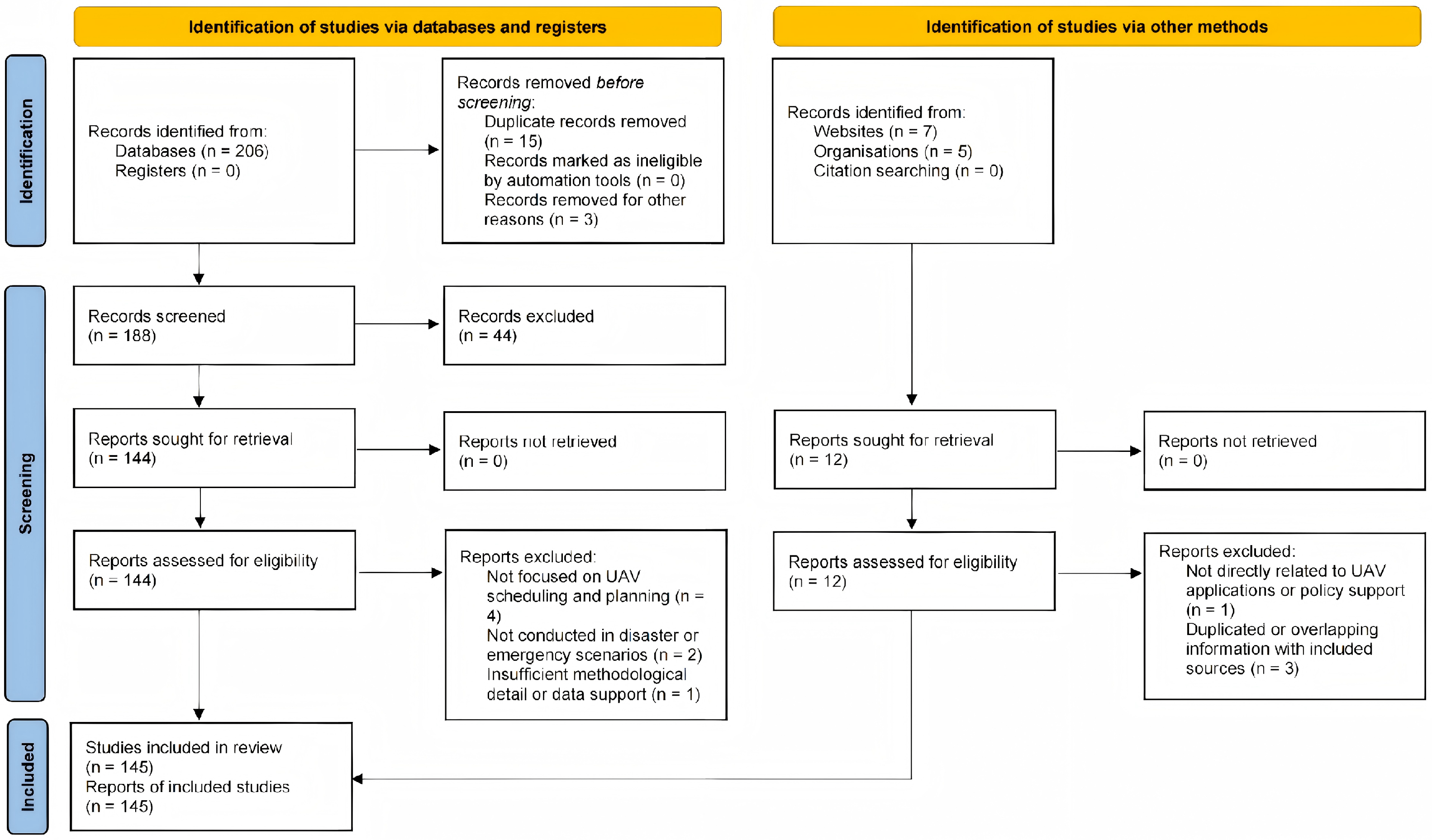
This systematic review was conducted and reported with reference to the PRISMA 2020 statement [21]. The literature selection process included database searching, duplicate removal, title and abstract screening, full-text assessment, and final inclusion of eligible studies. The detailed selection process is shown in the PRISMA flow diagram in Figure 1. This study conducted a systematic literature search over the past decade using the keywords “UAV disaster response”, “UAV scheduling and planning”, and “risk-driven UAV path planning” in the Web of Science and ScienceDirect databases. The last search was conducted on 20 April 2026, and all records retrieved up to that date were considered for screening. To improve the comprehensiveness and reproducibility of the search, Boolean operators were used to construct a unified search query as follows: (“UAV” OR “drone”) AND (“scheduling” OR “planning” OR “routing”) AND (“emergency” OR “disaster”) AND (“risk-driven” OR “risk-aware”).
Based on the initial retrieval results, a multi-stage screening process was conducted following standard systematic review procedures, including duplicate removal, title and abstract screening, and full-text assessment. A total of 145 studies most relevant to the research topic were finally selected, and the detailed selection process is illustrated in Figure 1.
To ensure the scientific validity and consistency of the selection process, explicit inclusion and exclusion criteria were applied. Only studies meeting the following criteria were retained: (1) the research focuses on UAVs and is conducted in emergency or disaster scenarios; (2) the model formulation and parameter settings are clearly described, with reliable and valid data sources; and (3) the study is of high quality and published in reputable journals or conferences. Studies that did not meet these criteria were excluded, including: (1) studies focusing solely on UAV hardware design or control without involving scheduling or planning; (2) studies lacking sufficient methodological detail or reliable data support; and (3) duplicate or irrelevant studies. In addition, to reduce subjective bias, the screening process was conducted independently by two reviewers, and any disagreements were resolved through discussion. After study selection, data were manually extracted and coded from the included studies by two reviewers. The extracted information included publication information, disaster scenario, operational stage, UAV SP paradigm, algorithm type, computational complexity, validation method, main results, evaluation metrics, and reported limitations. The two reviewers first extracted and checked the data independently, and any inconsistencies were resolved through discussion until a consensus was reached. When necessary, the full text of the original study was revisited to confirm ambiguous or incomplete information.
A risk-of-bias (RoB) assessment was performed for all included studies, tailored for computational UAV SP research. The evaluation was based on principles from Cochrane and GRADE and adapted to the characteristics of computational studies. Five domains were assessed: study design, data quality, validation, reporting completeness, and generalizability, each rated as Low, Some concerns, High, or No information.

3. Characteristics of Disaster Scenarios and UAV Task Execution Stages

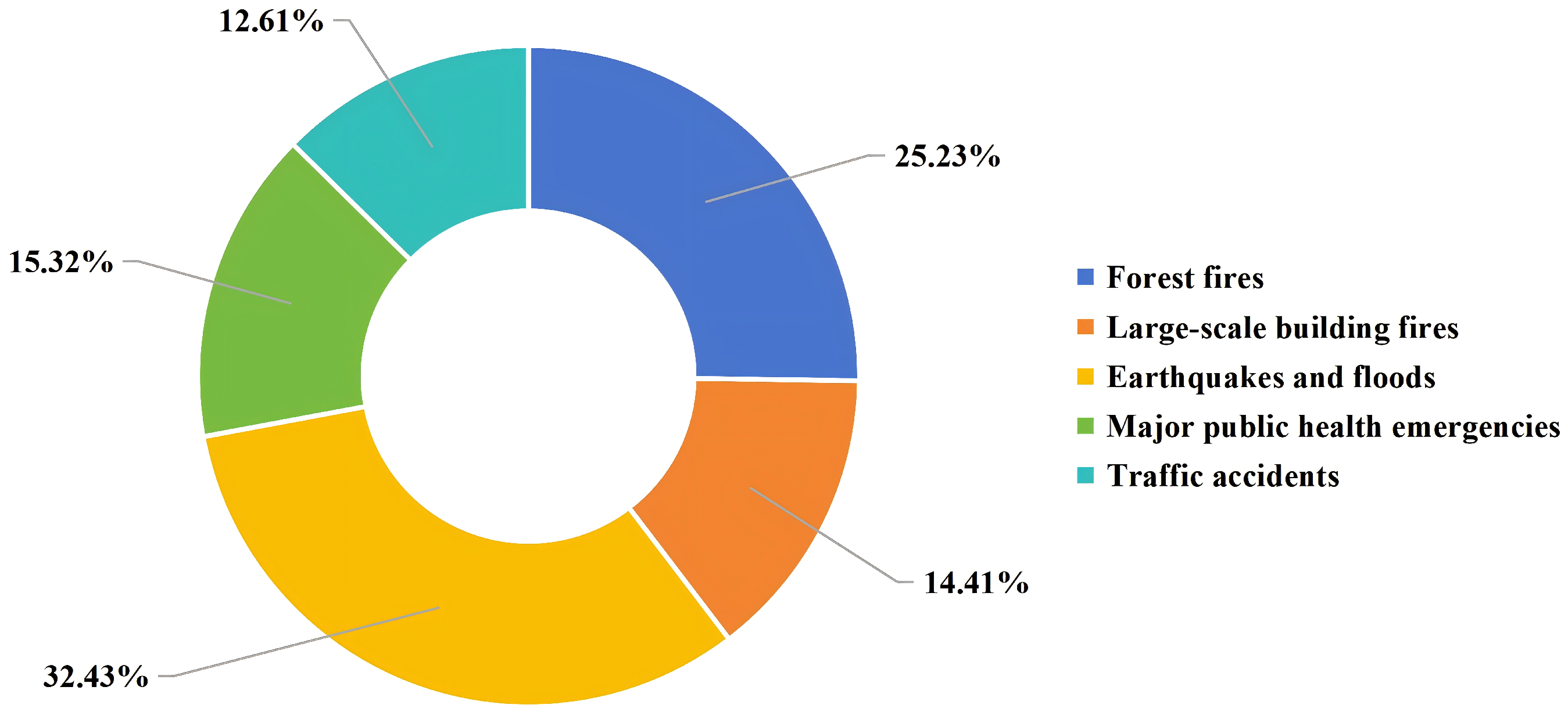
Based on the statistical analysis of the studies selected through the systematic review process, this study identifies six representative disaster scenarios, including forest fires, large building fires, earthquakes and floods, major public health emergencies, and traffic accidents, as shown in Figure 2 [22,23,24,25,26]. These categories are derived from the most frequently investigated application contexts in the collected studies and collectively capture the dominant operational environments addressed in existing UAV SP research. Although the classification may not be strictly exhaustive, it reflects the most representative and widely studied disaster scenarios in the current literature. The classification and corresponding proportions are derived from manual categorization of the selected studies according to their primary application scenarios.
Based on the above statistical analysis of the reviewed literature, this study further examines the characteristics of different disaster scenarios, highlighting the diverse environmental conditions and operational challenges faced by UAVs across fire, earthquake, flood, public health emergency, and traffic accident scenarios. These scenarios exhibit significant differences in meteorological and geographical characteristics, thereby imposing distinct requirements on UAV adaptability and task execution.

3.1. Disaster Scenario Characteristics

This section analyzes UAV task characteristics across representative disaster scenarios. Section 3.1.1, Section 3.1.2, Section 3.1.3, Section 3.1.4 and Section 3.1.5 cover five scenarios, while Section 3.1.6 summarizes their interaction mechanisms, providing a basis for subsequent analysis.

3.1.1. Forest Fires

In forest fire scenarios, complex mountainous terrain and thermal turbulence create harsh meteorological and geographical conditions. Limited accessibility constrains human responders, making UAVs essential for fire monitoring and suppression under low-visibility and strong airflow conditions. UAV flight stability and sensing accuracy are, however, strongly affected by terrain undulation, thermal disturbances, and smoke occlusion.
Human involvement can be broadly divided into two groups: firefighters and UAV operators. UAV operators perform key technical roles by remotely controlling UAV systems to acquire real-time fire ground data and assess critical indicators, including fire spread dynamics, burn extent, and intensity [27]. Forest fire sites often contain high-risk areas with limited accessibility, where complex conditions and safety hazards restrict direct firefighting operations. In response, UAV operators deploy UAV platforms equipped with specialized firefighting payloads, such as fire-extinguishing balls, to conduct precise aerial delivery in areas inaccessible to personnel, compensating for coverage limitations of conventional suppression methods.
Forest fires typically occur in remote areas away from urban built-up areas, where transport infrastructure is weak, road network density is low, and accessibility is limited [28]. Forest fire-prone areas are dominated by mountainous and hilly terrain, with pronounced elevation variation and complex surface features.
Forest fires alter local thermal and dynamical structures, disrupting ambient airflow and generating turbulence ranging from small-scale eddies to strong convective vortices, with characteristics that vary dynamically with fire intensity, terrain, and background atmospheric conditions [29]. Surface features such as trees and hills further induce small-scale turbulence and gusts that are typically beyond the resolution of conventional weather forecasting models [30]. Particulate matter (e.g., PM2.5 and PM10), gaseous pollutants (e.g., CO and VOCs), and water vapor generated during combustion combine to form dense smoke, substantially reducing visibility [31].
UAVs deployed for forest fires are predominantly multi-rotor platforms, with a maximum take-off weight of approximately 20 kg and a maximum operational range of about 40 km [32]. Such UAVs are typically equipped with temperature sensors to identify approximate fire locations, together with thermal imaging sensors and infrared cameras to delineate fire boundaries [33]. Given the higher temperatures in fire environments, UAVs often incorporate high-temperature-resistant materials, such as ceramic matrix composites, and active cooling systems to prevent thermal damage to onboard equipment [34].
Forest fires spread rapidly in open areas and typically occur in remote regions away from urban settlements. Owing to geographical constraints and limited infrastructure, these areas exhibit underdeveloped transport networks and predominantly mountainous and hilly terrain. These conditions constrain communication, resulting in insufficient wireless coverage and a high risk of communication outages during multi-UAV operations [35]. High temperature and disturbed airflow introduce multiple operational risks, degrading flight stability, increasing the likelihood of loss of control, and potentially causing thermal damage to onboard hardware [36]. In addition, complex terrain and dense smoke generated by combustion substantially reduce visibility, further increasing the risk of UAV collisions.

3.1.2. Large Building Fires

In large building fires, dense urban built-up areas combined with complex meteorological disturbances create high-risk airspace. Firefighting operations rely on UAVs to perform fire monitoring and suppression under conditions of dense smoke, high temperatures, and localized turbulence. Building obstruction, rising thermal plumes, and reduced visibility degrade UAV flight stability and sensing performance [37].
Human actors can be classified into four groups: trapped occupants within the fire zone, nearby residents, on-site firefighting and medical responders, and UAV operators. UAV operators provide essential technical support through remote control of UAV systems, with their roles primarily focused on situational sensing and intervention in high-risk areas. At the sensing level, UAVs equipped with high-definition cameras, thermal imaging sensors, and RGB sensors conduct area-wide scanning and dynamic monitoring to accurately locate trapped occupants and transmit real-time data [38]. This information enables responders to assess occupant distribution and optimize rescue routing, thereby improving efficiency and reducing casualty risk. At the intervention level, UAVs carrying firefighting payloads can deploy water or water-based extinguishing agents in areas inaccessible due to high temperatures, dense smoke, or structural instability [39]. This capability helps control local fire spread while avoiding direct exposure of responders and creating safer conditions for subsequent operations.
Large building fires typically occur in urban areas with high populations. Such areas are subject to dual airspace constraints: predefined no-fly areas and low-altitude civil UAV operations, such as commercial aerial imaging.
Similar to forest fires, combustion in large building fires disrupts local airflow structures and generates complex turbulence in the near-fire region. Dense buildings in urban areas further induce small-scale local turbulence and intermittent gusts that are difficult for conventional weather forecasting models to resolve [40]. These effects alter airflow patterns around the fire scene. In addition, dense smoke containing soot particles and products of incomplete combustion causes strong scattering and absorption of visible and infrared radiation, substantially reducing visibility in UAV operating airspace and ground rescue areas.
UAVs deployed for large building fires are predominantly multi-rotor platforms, with a maximum take-off weight of approximately 20 kg and a maximum operational range of about 40 km [32]. Similar to forest fire scenarios, these UAVs are typically equipped with RGB cameras and thermal infrared imagers to support fire ground sensing. Coordinated operation of multiple UAVs enables autonomous area coverage, transforms non-line-of-sight (NLOS) conditions into line-of-sight (LOS) access and supports accurate target localization within affected areas [34]. In complex urban electromagnetic environments, some UAVs incorporate interference-suppression and filtering algorithms to enhance robustness against electronic signal interference [41].
Large building fires predominantly occur in urban core areas with dense high-rise structures and high populations. Dense clusters of high-rise buildings form direct physical obstacles to UAV flight; collisions and subsequent crashes can interrupt rescue operations, damage equipment, and pose secondary risks to people on the ground. In addition, dense smoke generated by fires markedly reduces visibility, interferes with UAV localization systems, and degrades flight stability and mission accuracy.

3.1.3. Earthquakes and Floods

In earthquake and flood disasters, extreme weather conditions and damaged built environments jointly restrict ground accessibility and disrupt local airflow [42]. Under such conditions, rescue operations rely on UAVs to conduct search and rescue and supply delivery under strong winds, rainfall, and reduced visibility [43]. Meanwhile, UAV operational safety and sensing capability are constrained by terrain damage, meteorological disturbances, and infrastructure failure.
Human actors can be grouped into three categories: affected populations, rescue personnel, and UAV operators. Rescue personnel mainly comprise rescue forces and medical staff, who undertake on-site search, rescue, and medical response tasks. UAV operators provide technical support by controlling UAV systems to enable accurate localization of affected populations and area-wide searching. UAVs also deliver medical supplies and essential goods, including medicines, bandages, foods, and drinking water.
Transport infrastructure is prone to widespread damage; roadways may collapse, and critical nodes such as bridges and tunnels can be impaired or rendered impassable [44]. Collateral impacts, including collapsed buildings and fallen trees, reshape the physical environment, increasing operational resistance and exposure to environmental disturbances for UAVs. These factors pose significant challenges to reliable UAV-based rescue operations.
Earthquake and flood events are commonly accompanied by complex meteorological conditions, such as persistent rainfall, strong winds, gusts, turbulence, and severely reduced visibility [45]. During earthquakes, energy release elevates surface temperatures and accelerates moisture evaporation [46]. Vapor released along surface fractures enhances updrafts, thereby promoting local turbulence and rainfall. During floods, strong winds, gusts, and unsteady turbulence intensify hydrodynamic processes, expand inundation extent and accelerate hazard evolution. Extensive surface water promotes evaporation, leading to local fog or low cloud formation [47]. Residual aerosols and increased surface reflectance further degrade near-surface visibility.
UAVs deployed for earthquake and flood response are mainly multi-rotor or fixed-wing platforms, with a maximum take-off weight of approximately 50 kg and a maximum operational range of about 70 km [32]. These UAVs are typically equipped with thermal imaging cameras to detect human heat signatures and localize trapped individuals. Multispectral sensors are also employed to assess the extent and severity of building damage. Inertial measurement units, global positioning systems and multi-hole pressure probes are commonly integrated.
Road network performance is highly uncertain, requiring dynamically adaptive scheduling for coordinating ground vehicles and UAVs. Collapsed buildings, damaged infrastructure, and fallen vegetation create a complex obstacle environment for low-altitude UAV operations [48]. Adverse weather, including precipitation and atmospheric turbulence, directly threatens flight safety and degrades mission efficiency and operational reliability. A single UAV is often insufficient for complex missions, necessitating multi-agent coordination, including other UAVs and ground mobile platforms. Scheduling for such coordination systems must jointly consider mission objectives, network topology, and meteorological conditions to achieve robust and efficient system performance.

3.1.4. Major Public Health Emergencies

In major public health emergencies, dense urban buildings and variable weather jointly constrain logistics and airspace access. Medical and operational staff rely on UAVs to perform contactless delivery and monitoring in restricted areas under diverse weather conditions [49]. UAV communication stability and flight safety are affected by building obstruction, local turbulence, and weather variability.
Four human groups are identified: healthcare workers, quarantined individuals, UAV operators, and the general public. UAV operators remotely control UAV systems to deliver essential supplies, such as food and masks, to quarantined individuals, enabling contactless delivery and reducing occupational exposure risks for healthcare workers [50]. UAVs are also used to deliver critical medical supplies, including blood products and medicines, improving delivery efficiency and ensuring timely medical treatment. In addition, UAV operators conduct routine patrol over restricted areas and their boundaries to identify abnormal activities and track individual trajectories. When required, the UAV also guides evacuation and relocation of confined people.
Major public health emergencies often occur in urban areas with high population and building densities. Post-event containment measures frequently disrupt local road networks and traffic operations [51]. Urban low-altitude air traffic management also includes no-fly zones. Rescue scheduling needs to consider both road network disruptions and airspace restrictions that affect coordination between UAVs and ground vehicles.
Adverse weather conditions such as precipitation and strong wind are generally predictable using standard meteorological forecasting methods [52]. Local turbulence generated within and between building clusters in these areas often lies beyond the effective resolution of standard forecasting methods.
UAVs deployed for major public health emergencies are mainly multi-rotor or fixed-wing platforms, with a maximum take-off weight of approximately 50 kg and a maximum operational range of about 70 km [32]. These UAVs are typically equipped with high-definition RGB cameras for routine patrol of restricted areas and their boundaries, enabling timely detection of abnormal activities.
UAVs are used for delivery of relief supplies such as medicines and vaccines, constrained by both infrastructure and environmental conditions. Road closures and traffic control restrict local road access, highlighting the ability of UAVs to bypass conventional transport networks, while take-off, landing, and last-mile access remain dependent on road accessibility. Temporary airspace control measures require UAVs to maintain real-time communication with ground command systems and ensure collision avoidance [53]. Signal obstruction in dense urban built environments, together with the spatial distribution of medical facilities, quarantine sites, and vaccination centers, shapes the transport network, while the limited availability of safe take-off and landing sites further constrains UAV deployment [54].

3.1.5. Traffic Accidents

In traffic accident scenarios, rescue personnel rely on UAVs to obtain accident locations, congestion conditions, and casualty distribution, and to provide aerial guidance and deliver relief supplies. UAV operational performance is influenced by control decisions, low-altitude environmental disturbances, and time-varying weather conditions.
Traffic accident response involves UAV operators, accident victims, drivers of passing vehicles, and on-site rescue personnel. UAV operators use aerial platforms for rapid situational sensing and precise localization of the accident area. UAVs also deliver small-scale disaster supplies, such as blood products and medicines, improving accessibility and timeliness during urgent response. When the accident disrupts local traffic flow and causes lane congestion, UAV operators can use aerial views to guide vehicle movements and provide dynamic traffic information and routing advice, improving area throughput and reducing the risk of secondary accidents [55].
Traffic accidents commonly occur in structurally complex urban road environments, where the spatial form is constrained by dense concentrations of buildings, flyovers, separation facilities, and green belts. As congestion builds up, vehicle and pedestrian densities increase, complicating traffic flow dynamics and restricting access to response resources.
In urban areas, both macro- and micro-scale atmospheric factors influence UAV operations. Predictable weather processes, including rainfall, strong wind, and fog, can directly affect flight performance and sensor performance. Fine-scale turbulence driven by high-speed vehicles, wind channel effect between building clusters, and local thermodynamic inhomogeneity are highly stochastic and unpredictable and thus cannot be accurately characterized by conventional meteorological forecasting models [56]. Such atmospheric disturbances reduce flight stability and degrade sensing quality during monitoring tasks.
UAVs deployed for traffic accidents are typically fixed-wing or multi-rotor platforms, with a maximum take-off weight of approximately 50 kg and a maximum operational range of about 70 km [32]. These UAVs are typically equipped with high-resolution RGB cameras and thermal imaging sensors to capture accident scene imagery and locate casualties during the night.
UAVs are primarily used for rapid accident localization and visual documentation, congestion sensing and vehicle guidance, and the delivery of small disaster supplies. Such tasks are highly sensitive to operational environments and meteorological conditions. Traffic accidents often occur in complex road networks with large spatial extent and dense traffic elements [57]. A single UAV, constrained by endurance and energy consumption, is often insufficient to independently support wide-area and time-critical operations. Multi-UAV coordination or air–ground coordination can improve overall operational efficiency and system robustness.

3.1.6. Interaction Mechanisms of Disaster Scenario Elements

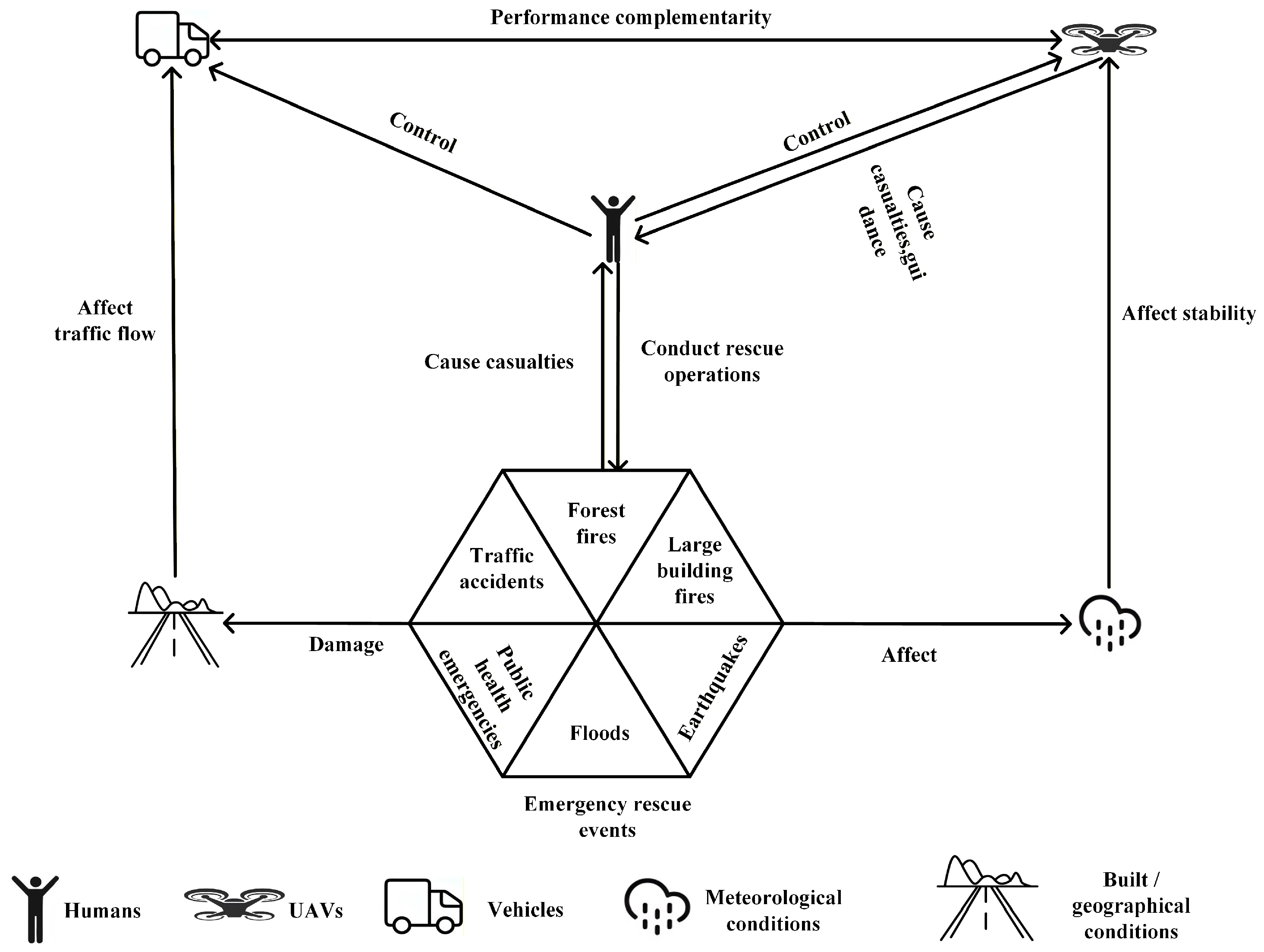
Figure 3 presents the interrelations among the elements involved in the disaster scenarios described in Section 3.1.1, Section 3.1.2, Section 3.1.3, Section 3.1.4 and Section 3.1.5. Specifically, disaster scenarios can be characterized by four fundamental components, including humans, UAVs, ground vehicles, and environmental conditions (meteorological and built/geographical factors), which are interconnected through dynamic and bidirectional relationships.
Environmental conditions, including meteorological and built/geographical factors, play a dual role in the system. On the one hand, they affect UAV stability and thus constrain flight safety and operational performance [58]. On the other hand, damage to the built and geographical environment influences traffic flow, leading to impeded ground vehicle operations and reduced emergency response efficiency [59].
Humans are both direct victims of disasters and the primary decision-makers and executors of rescue operations. After a disaster occurs, they carry out emergency response activities while being constrained by environmental conditions and infrastructure damage. UAVs and ground vehicles, as key operational agents, exhibit complementary roles. UAVs interact with humans through aerial inspection and material delivery, enhancing situational awareness and reducing exposure to high-risk environments. Ground vehicles are closely linked to traffic flow and infrastructure conditions, and their operation is constrained by road damage and congestion, thereby limiting response efficiency.
Meanwhile, UAVs and ground vehicles exhibit strong performance complementarity [60]. UAVs offer high mobility and rapid response, whereas ground vehicles provide higher payload capacity and stronger logistical support. Their coordination significantly improves the efficiency and robustness of disaster response.
Overall, Figure 3 indicates that disaster scenarios form a multi-layered coupled system involving disaster evolution, environmental constraints, and multi-agent coordination. This interaction implies that UAV SP should explicitly consider the coupling among environmental conditions, agents, and tasks rather than treating it as an isolated optimization problem, thereby providing a foundation for subsequent analysis.

3.2. Phases of UAV Task Execution

Based on the synthesis of representative studies on UAV applications in disaster response, a phase-based classification (pre-disaster, during-disaster, and post-disaster) is introduced to systematically analyze the evolution of UAV tasks and technical requirements, revealing that mission priorities dynamically change as disasters evolve. To improve the transparency of the synthesis process, representative references supporting the main task categories are provided in Table 1.

4. UAV SP Methods and Applications in Disaster Scenarios

Commercial initiatives, such as Domino’s drone delivery services and Amazon Prime Air, have demonstrated the potential of UAVs in urban logistics [69,70]. These applications are typically supported by stable infrastructure and predictable demand patterns, which has attracted substantial academic attention.
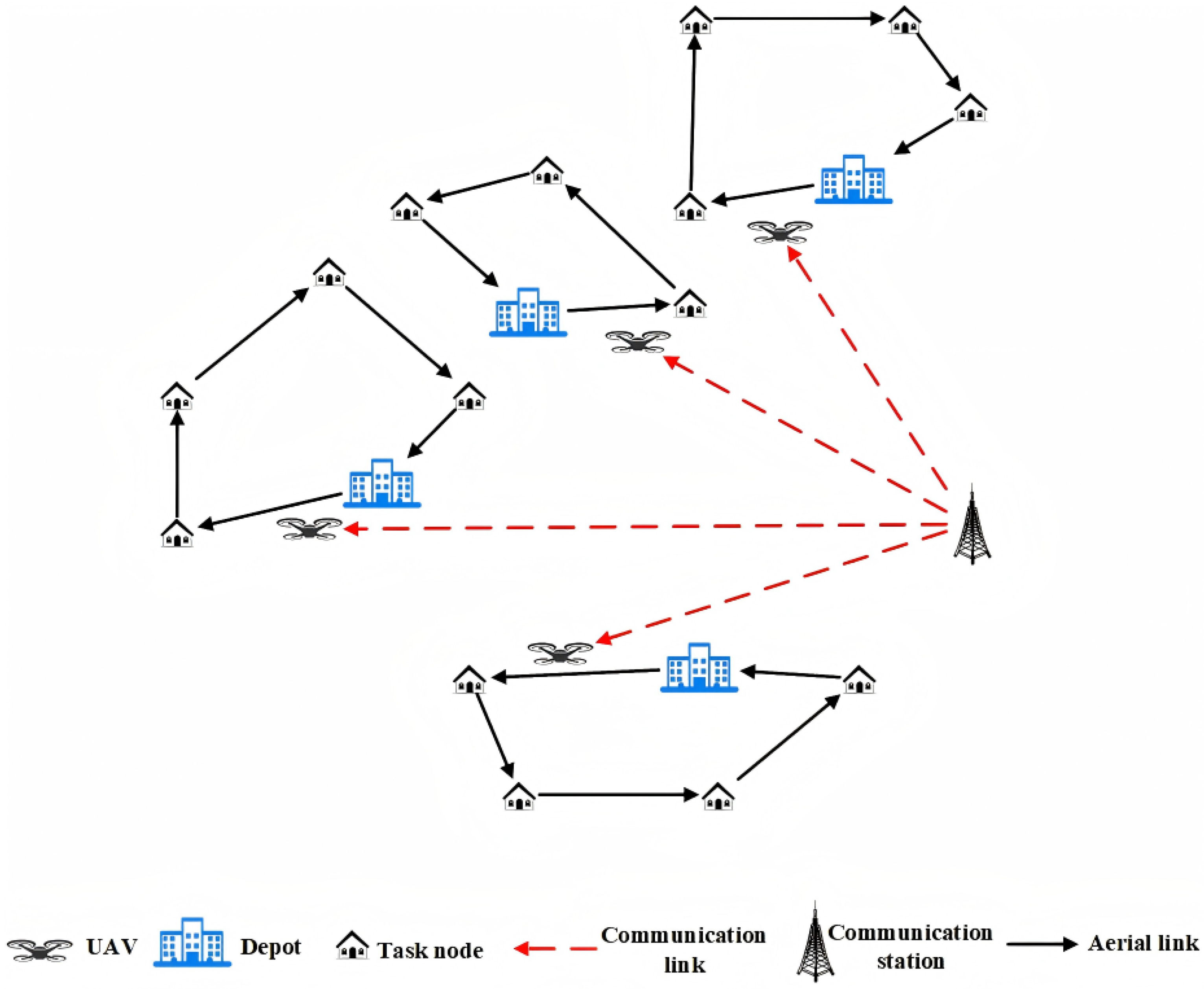
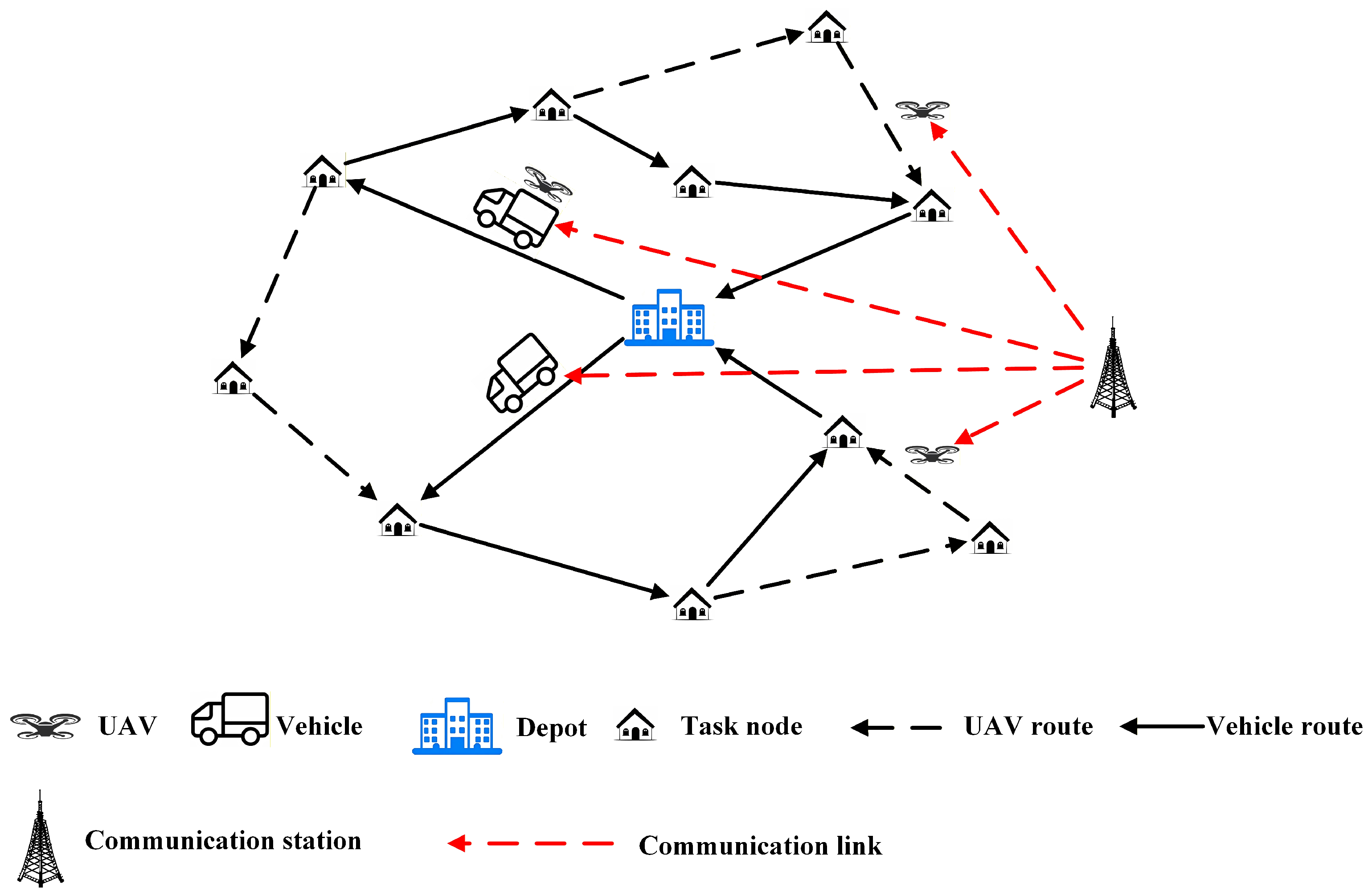
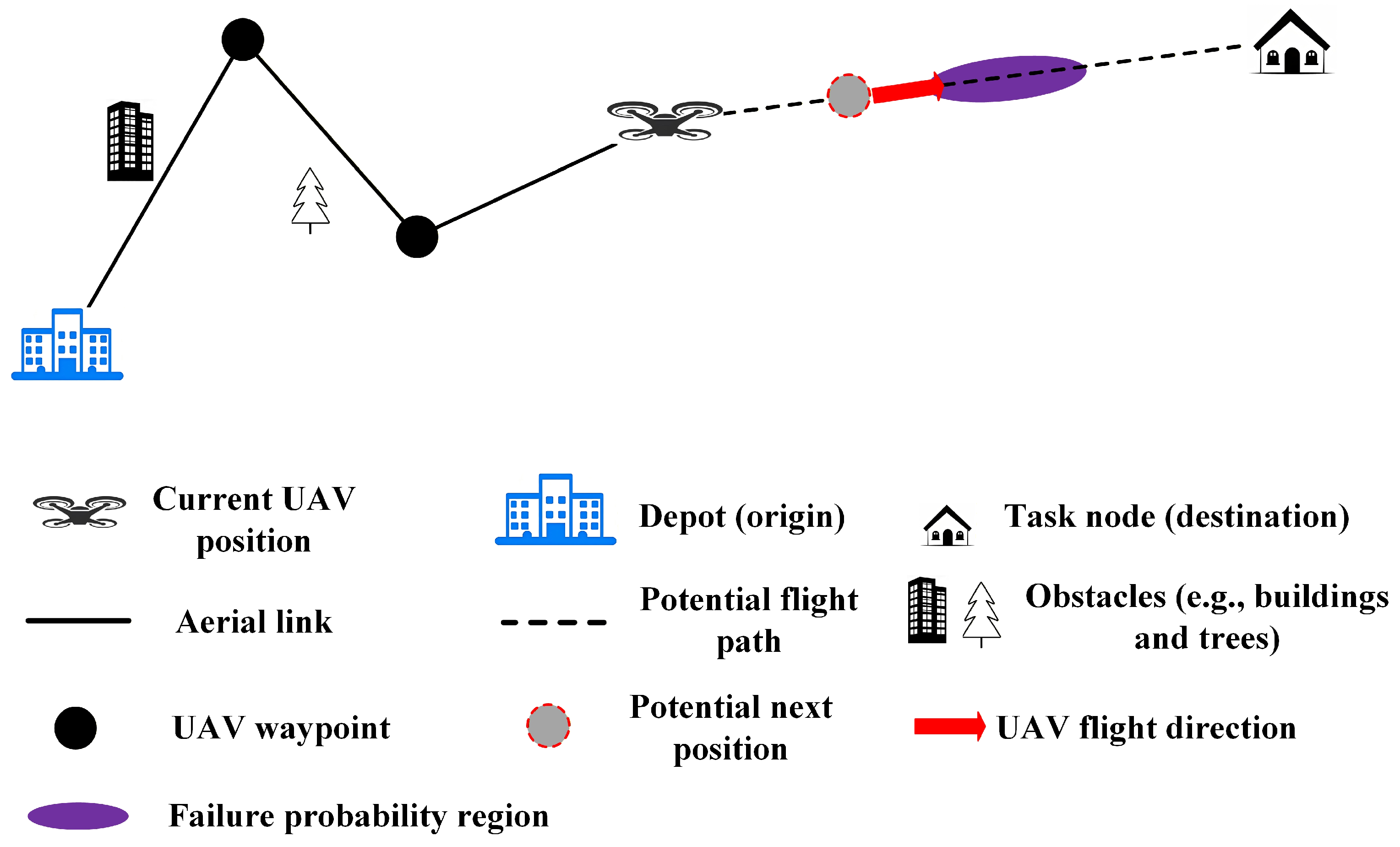
Pasha et al. define UAV scheduling as a multi-dimensional decision problem involving flight path optimization, task assignment, resource coordination, and temporal constraints. It can be understood as the joint planning of task selection, execution priorities, and arrival times, closely linked with trajectory optimization [71]. Building on this perspective, this study incorporates task selection, task assignment, scheduling, and flight path design into a unified UAV SP framework, enabling a systematic analysis of decision-making problems across different levels in the existing literature. Based on a synthesis of existing studies, three representative paradigms of UAV SP in disaster scenarios are abstracted and illustrated as conceptual schematics in Figure 4, Figure 5 and Figure 6, capturing the core operational logic and interaction structures commonly adopted in the literature [62,72,73].
The literature is categorized into the following groups:
(1)
Multi-UAV coordinated SP: During disasters, road infrastructure is often damaged and operation areas are extensive. Owing to energy constraints, a single UAV is typically unable to provide full area coverage. As a result, multi-UAV coordination is commonly adopted to support reconnaissance and material transport in affected areas (see Figure 4).
(2)
Air–ground coordinated SP: Ground vehicles offer high payload capacity, enabling the transport of heavy supplies and serving as mobile charging stations or take-off and landing platforms for UAVs. In contrast, UAVs provide high flexibility, allowing the transport of lightweight materials and area inspection when road infrastructure is damaged. The air–ground coordinated SP paradigm integrates the complementary operational capabilities of UAVs and ground vehicles (see Figure 5).
(3)
Risk reduction-oriented SP: Disasters are often accompanied by adverse meteorological conditions, such as precipitation and strong winds, and affected areas commonly contain obstacles, such as collapsed buildings and fallen trees. Accordingly, risk reduction-oriented UAV SP aims to balance operational safety and transport efficiency (see Figure 6).
Not all three technical directions are equally represented in every disaster scenario; in some cases, certain approaches overlap or are implicitly integrated within others. Nevertheless, the three categories collectively provide a coherent analytical framework for understanding UAV SP in disaster environments.

4.1. Pre-Disaster Stage

This section analyzes UAV SP methods in the pre-disaster stage. Section 4.1.1, Section 4.1.2 and Section 4.1.3 focus on forest fires, floods, and traffic accidents, respectively, while Section 4.1.4 provides a synthesis of methods and evaluation metrics.

4.1.1. Forest Fires

In the pre-disaster stage of forest fires, UAVs perform large-scale aerial patrols to identify potential fire risks and support early warning, provide real-time aerial situational awareness and route guidance for ground patrols, and enable pre-positioned delivery of lightweight firefighting supplies [74,75,76]. UAV SP plays a central role in converting pre-disaster forest fire monitoring tasks into executable operational plans.
Xu proposed a risk-aware multi-UAV patrol scheduling strategy for large-scale forest fire monitoring, which integrates forest fire risk maps with Gaussian mixture clustering and ring self-organizing maps while considering spatially heterogeneous fire risk, UAV endurance constraints, and coordination efficiency [22]. Tükenmez and Özkan addressed the multi-visit UAV patrol scheduling problem in forest fire prevention by formulating a multi-constraint model that captures heterogeneous fire sensitivity and revisit requirements and developing local search and simulated annealing heuristics to improve solution quality under complex constraints [77].
Regarding air–ground coordinated SP methods, Momeni et al. addressed early forest fire detection under terrain-induced access limitations and UAV endurance constraints by developing a multi-objective truck–UAV coordinated scheduling model, achieving improved coverage, higher patrol efficiency, better scalability, and reduced time and cost [78]. Momeni et al. examined early wildfire detection under insufficient coverage, terrain-induced access limitations, and cost-time uncertainty by developing a bi-objective truck–UAV coordinated model that integrates multi-altitude UAV operations and mobile truck-based take-off and landing, resulting in improved detection coverage and efficiency with reduced patrol cost [79].
For risk reduction-oriented SP, Bai et al. examined path planning in complex flight environments by developing a global–local coordinated framework that integrates an improved A* algorithm with an adaptive DWA algorithm while accounting for irregular obstacle geometry and UAV motion constraints, achieving improved obstacle avoidance and path smoothness with reduced flight path length [80]. Safaoui et al. investigated safe multi-agent UAV motion planning under uncertainty by integrating reinforcement learning with constraint-based trajectory planning, explicitly modeling uncertainty in perception, motion, and workspace, achieving improved safety and feasibility for real-time multi-UAV operations [81]. To provide a clearer comparison and analytical perspective, representative UAV SP methods in the pre-disaster stage of forest fire scenarios are summarized in Table 2, highlighting their differences in computational complexity, validation approaches, performance, and limitations.
The reviewed methods exhibit clear trade-offs in performance, scalability, robustness, and computational complexity. Optimization-based approaches achieve high solution quality through explicit constraint modeling but suffer from high computational cost and limited scalability [78,79]. Heuristic, metaheuristic, and clustering-based methods improve efficiency and scalability at the expense of optimality and robustness [22,77]. Graph-search-based and local reactive planning methods are computationally efficient for trajectory generation but are mainly limited to local optimization and lack support for complex scheduling tasks [80]. In contrast, learning-based approaches offer stronger adaptability in uncertain environments but require high training cost and lack interpretability [81].
A clear trend is the shift toward data-driven and adaptive methods, with increasing attention to uncertainty and dynamic environments. However, most studies remain task-specific, with limited integration of dynamic risk, communication constraints, and real-time coordination.
In practice, optimization-based methods suit small-scale problems with strict constraints, heuristic and clustering-based methods suit large-scale scenarios, and learning-based approaches are preferable for highly dynamic environments. Hybrid frameworks that combine efficiency and adaptability are therefore promising.

4.1.2. Floods

In the pre-disaster stage of floods, UAVs support multi-source monitoring and logistics within flood risk management systems. They conduct high-frequency inspections of levees and revetments to assess structural safety, monitor river surface flow velocity to identify obstruction risks, rapidly inspect bridges to evaluate pre-flood damage and monitor slope stability to provide early warning of secondary hazards [82,83,84,85]. During flood seasons, UAVs also deliver lightweight flood-control supplies to support pre-positioned ground response.
Risk reduction-oriented UAV SP focuses on adverse wind-related meteorological conditions and complex terrain, aiming to reduce the effects of static and dynamic environmental factors on flight stability. Guo et al. addressed real-time UAV path planning in dynamic environments with moving threats by developing a hierarchical RRT-based approach that integrates potential-function-based inertial planning with low-cost optimization while accounting for time-varying threats and motion constraints, achieving improved path optimality and safety [61]. Moon et al. studied time-optimal UAV path planning under constant wind fields and considered UAV kinematics, turn-rate constraints, and uniform wind disturbance, adopting a trochoidal path planning method based on coordinate transformation and modified Dubins decision tables, achieving reduced computational cost and solution time with improved efficiency, accuracy, and robustness [86]. Chen et al. investigated multi-rotor UAV operations in three-dimensional turbulent wind environments and considered UAV motion dynamics, energy constraints, and wind-induced disturbances, adopting a reinforcement learning-based energy-efficient path planning algorithm, achieving reduced energy consumption and improved attitude stability under turbulent conditions [87]. Representative UAV SP methods in the pre-disaster stage of floods are compared in Table 3.
The reviewed methods exhibit clear trade-offs in performance, scalability, robustness, and computational complexity. Sampling-based path planning methods support real-time planning in dynamic environments but are sensitive to environmental complexity [61]. Geometric and analytical methods are computationally efficient for time-optimal planning under wind conditions, yet they rely on simplified assumptions [86]. In contrast, learning-based approaches show stronger robustness and adaptability in uncertain environments at the cost of high training complexity and limited interpretability [87].
A clear trend is the shift from geometric and sampling-based methods toward adaptive and environment-aware approaches, with increasing attention to disturbances and energy constraints. However, most studies remain focused on trajectory-level planning, with limited integration of communication constraints, dynamic risk, and real-time coordination.
In practice, sampling-based methods are suitable for dynamic real-time planning, geometric methods for computationally efficient scenarios, and learning-based approaches for highly uncertain environments. Hybrid frameworks that combine efficient planning with adaptive learning are therefore promising.

4.1.3. Traffic Accidents

In the pre-disaster stage of traffic accidents, UAVs conduct routine road infrastructure inspections to identify potential safety hazards and continuously monitor traffic flow and vehicle behaviors to support traffic risk assessment [88,89].
Multi-UAV coordinated SP addresses the limited coverage and response range of single UAVs. Wang and Shang examined UAV-based pre-positioning for rapid urban traffic accident assessment under uncertain accident distribution, road discretization, coverage limits, and accident severity. A cost-minimization siting model, solved using an improved simulated annealing heuristic with multi-neighborhood and tabu strategies, improves coverage and response speed while reducing congestion-related costs and uncovered incidents [62]. Meng et al. addressed delays in on-site traffic accident assessment and considered spatiotemporal accident patterns and road network accessibility, adopting a data-driven accident prediction and UAV pre-positioning optimization framework, achieving reduced response time and improved coverage efficiency [90]. Zhang et al. investigated traffic event monitoring inefficiencies caused by limited sensor coverage and static UAV routing and considered the spatiotemporal propagation of traffic congestion together with UAV operational constraints, adopting a spatiotemporal network-based dynamic UAV path planning model, achieving improved coverage, detection efficiency, and network observability with reduced misses, delays, and operational cost [91].
Regarding air–ground coordinated SP, Cheng et al. addressed the limited mobility and coverage of conventional traffic patrols and considered task allocation characteristics and arc-access constraints, adopting a two-stage truck–UAV coordinated arc-routing optimization framework, achieving improved solution efficiency and path quality for large-scale patrol tasks [72].
For risk reduction-oriented UAV SP methods, Li et al. addressed urban traffic patrols with highly uncertain UAV endurance by explicitly modeling task-level flight-time deviations and formulating a robust multi-UAV path planning model based on budgeted uncertainty sets. The proposed approach, solved using adaptive large neighborhood search combined with simulated annealing, reduces interruption risk due to endurance uncertainty and improves patrol efficiency and path stability [73]. Kumar et al. addressed limitations of conventional road traffic monitoring systems, including restricted coverage and high computation and communication cost, and integrated software-defined networking with UAV networks to form an SDDN architecture, which expands monitoring coverage while reducing overhead and improving energy efficiency and latency [92]. Representative UAV SP methods in the pre-disaster stage of floods are compared in Table 4.
The reviewed methods reveal clear trade-offs among solution quality, scalability, robustness, and computational complexity. Optimization-based approaches provide strong theoretical guarantees and high-quality solutions but often suffer from high computational cost and limited scalability [73,90,91]. In contrast, heuristic and hybrid methods significantly improve computational efficiency and scalability, enabling near-optimal solutions within acceptable time, yet without guarantees of global optimality [62,72]. Reactive or rule-based approaches further enhance real-time responsiveness and adaptability but are typically restricted to local decision-making and lack system-level coordination [92].
A clear trend is the integration of optimization models with heuristic or adaptive strategies to balance solution quality and computational efficiency. However, existing studies still predominantly focus on static or simplified settings, with limited attention to large-scale coordination, real-time adaptability, and dynamic risk.
In practice, optimization-based methods are suitable for small-scale, accuracy-critical problems, while heuristic and hybrid methods are more appropriate for large-scale or time-sensitive applications. Robust optimization is essential in uncertainty-sensitive scenarios, and integrating robustness into scalable heuristic frameworks represents a promising research direction.

4.1.4. Synthesis of Methods and Metrics

Across the pre-disaster stage, optimization and heuristic approaches dominate, mainly for scheduling, pre-positioning, and coordination problems. Trajectory-level path planning methods support environment-constrained motion planning, while learning-based approaches remain complementary for handling uncertainty.
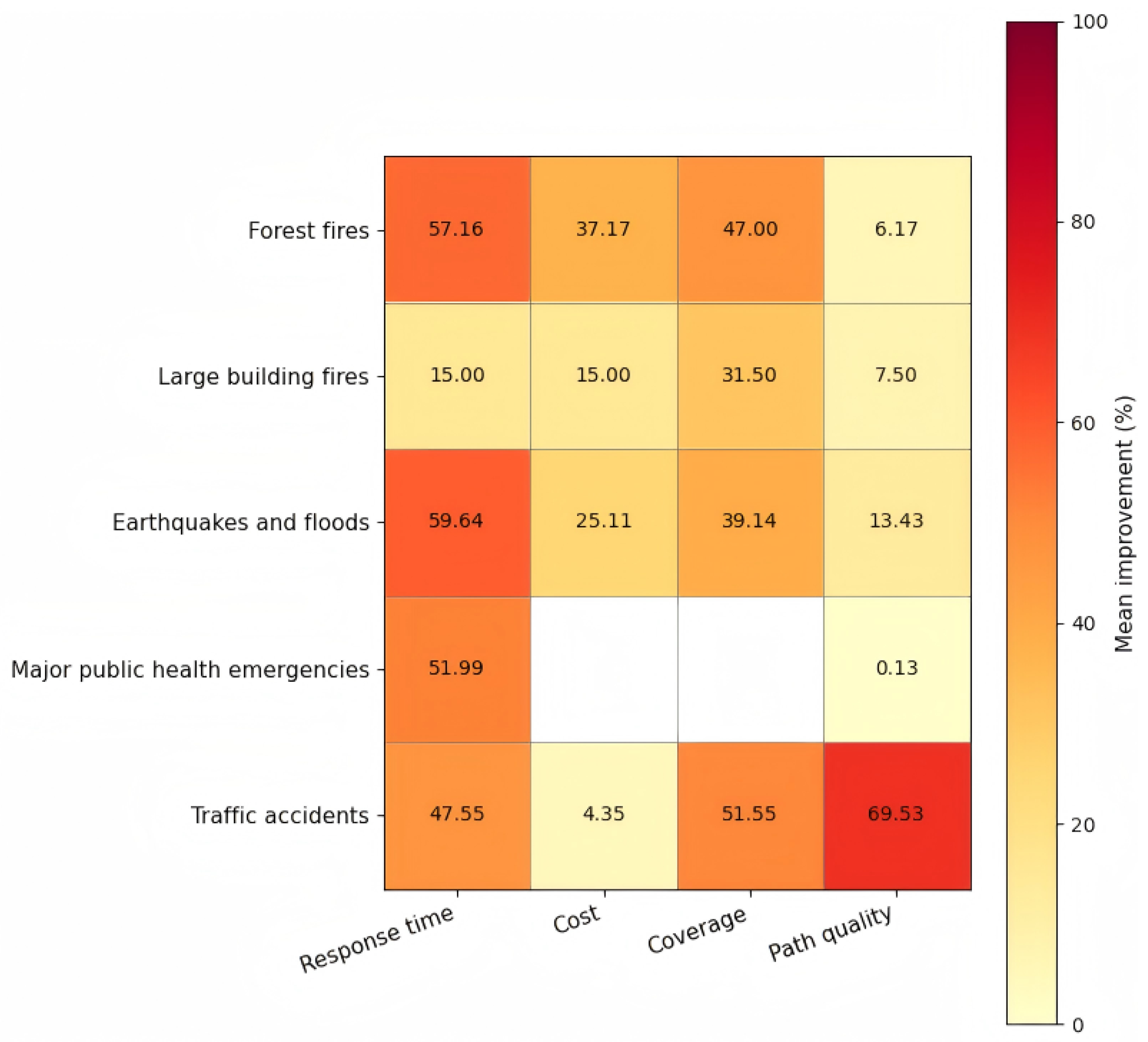
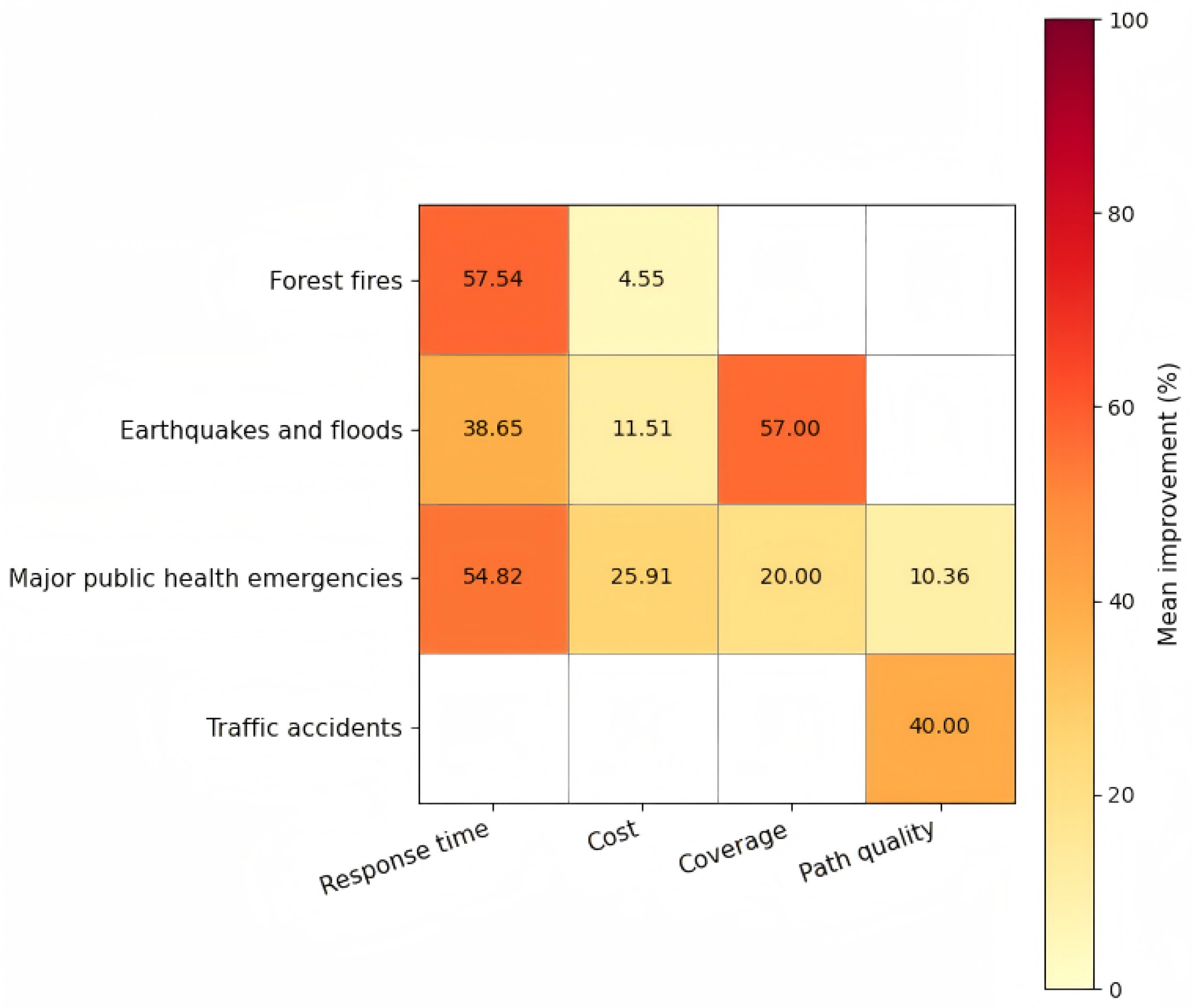
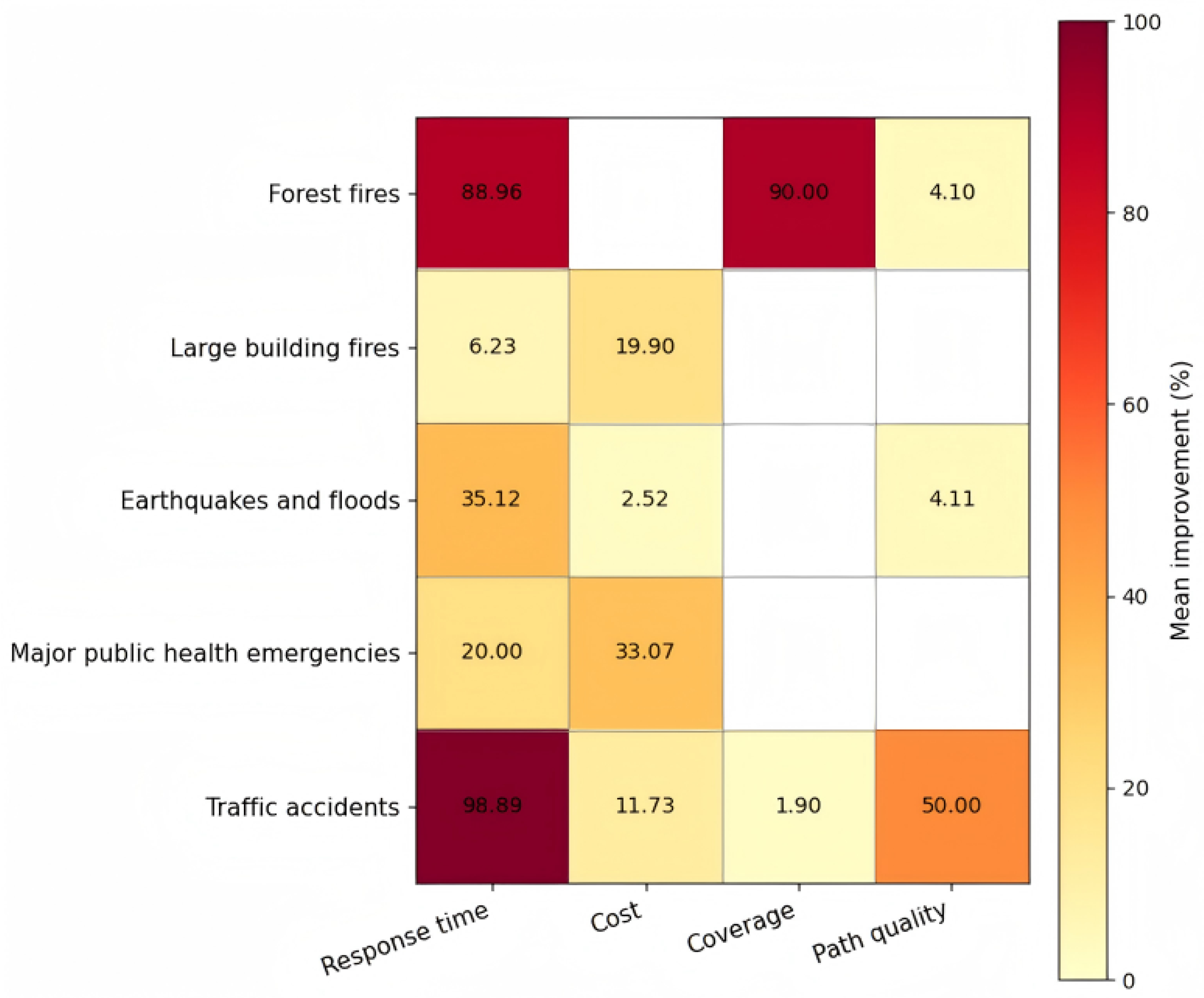
Most studies rely on common metrics, including coverage, response time, cost, and path quality, whereas robustness-related indicators are less standardized. Overall, current research remains efficiency-oriented, with limited attention to dynamic risk and system-level performance.

4.2. During-Disaster Stage

This section analyzes UAV SP methods in the during-disaster stage. Section 4.2.1, Section 4.2.2, Section 4.2.3 and Section 4.2.4 focus on forest fires, large building fires, earthquakes and floods, and major public health emergencies, respectively, while Section 4.2.5 provides a synthesis of methods and evaluation metrics.

4.2.1. Forest Fires

In the during-disaster stage of forest fires, UAVs support four key functions: fire source localization and fire spread monitoring using thermal and infrared sensors; rapid search for trapped individuals and auxiliary support such as evacuation guidance; rapid delivery of firefighting equipment and medical supplies; and real-time information broadcasting for evacuation and hazard warning, enhancing situational awareness and response effectiveness [93,94,95].
UAVs were deployed in the March 2024 wildfire response in Yajiang County, Sichuan, where complex terrain and rapidly changing fire dynamics posed significant monitoring challenges. Hybrid fixed-wing UAVs with long endurance and multi-sensor fusion were used for wide-area patrols and fire-source verification. Real-time infrared imagery and fire spread data enabled the command center to dynamically adjust suppression strategies [96].
For multi-UAV coordinated SP methods, Momeni and Mirzapour Al-e-Hashem addressed delayed detection and inefficient response in forest fires by explicitly modeling rapid fire spread, heterogeneous suppression demands, and UAV endurance and sensing limits within a mixed-integer linear programming (MILP) framework for UAV-based firefighting. The hybrid Clark–Wright and local search solution improves routing efficiency, firefighting timeliness, and monitoring coverage [63].
Regarding risk reduction-oriented UAV SP methods, Luo et al. examined inefficient and poorly adaptive UAV path planning in forest fire response by explicitly considering complex three-dimensional environments. By integrating hierarchical planning with a map-scaling strategy, they developed an improved D* Lite algorithm that enables three-dimensional static and dynamic obstacle avoidance while substantially reducing planning time [97]. Representative UAV SP methods in the during-disaster stage of forest fires are compared in Table 5.
The reviewed methods exhibit a clear trade-off between global optimality and computational efficiency. Optimization-based models provide high-quality global solutions but suffer from high computational complexity and limited scalability [63]. In contrast, search-based methods significantly improve computational efficiency and real-time performance but lack global coordination and optimality guarantees [97].
In terms of robustness, optimization-based approaches rely on deterministic assumptions and predefined infrastructure, while search-based methods show better adaptability in dynamic and partially known environments.
A clear trend is the shift toward integrating global optimization with real-time search mechanisms. However, existing studies still mainly separate global planning from local decision-making, with limited consideration of unified system-level coordination.
In practice, optimization-based methods are suitable for small-scale strategic planning, while search-based methods are more appropriate for real-time applications. Hybrid frameworks that combine global optimization with fast replanning are therefore a promising direction.

4.2.2. Large Building Fires

In the during-disaster stage of large building fires, UAVs support time-critical response tasks, including high-precision localization of internal fire sources and dynamic fire spread monitoring for command-level situational awareness, rapid localization and condition assessment of trapped occupants to support rescue scheduling, and aerial assessment of evacuation route accessibility [98,99,100,101]. UAVs can also conduct targeted local fire suppression and deliver firefighting equipment and medical supplies, improving response efficiency and resource delivery capacity.
Multi-UAV coordinated SP focuses on improving area coverage and sensing accuracy to enhance monitoring efficiency for high-rise buildings. Liu et al. addressed low monitoring efficiency in multi-UAV surveillance of high-rise building fires by explicitly modeling dynamic fire evolution and distance-dependent observation degradation. The proposed DragonFly coordinated system, which integrates task assignment with dynamic waypoint scheduling, improves event capture rates, situational awareness accuracy, and monitoring coverage [23].
For risk reduction-oriented UAV SP, Mugnai et al. investigated obstacle avoidance and precise payload delivery for autonomous UAV firefighting in high-rise buildings by explicitly considering dynamic motion constraints and ballistic accuracy requirements. The proposed modular system, which combines reactive local planning with optimal trajectory planning, increases obstacle-avoidance success rates and reduces task completion time [102]. Representative UAV SP methods in the during-disaster stage of large building fires are compared in Table 6.
The reviewed methods exhibit a clear trade-off between global coordination capability and real-time performance. Optimization-based scheduling methods improve monitoring accuracy through task allocation and waypoint scheduling but suffer from high computational complexity and limited scalability [23]. In contrast, search-based planning methods enable efficient real-time obstacle avoidance but focus on local trajectory optimization without system-level coordination [102].
In terms of robustness, scheduling methods rely on predefined environmental information and communication, while reactive planning methods show better adaptability in dynamic and partially known environments.
A clear trend is the separation between global SP. However, existing studies still lack integrated frameworks that simultaneously address multi-UAV coordination and real-time adaptability.
In practice, scheduling methods are suitable for mission-level planning, while search-based methods are more appropriate for real-time execution. Hybrid frameworks that combine global coordination with fast local replanning are therefore promising.

4.2.3. Earthquakes and Floods

In the during-disaster stage of earthquakes and floods, UAVs support multiple response functions. Multi-source sensing is used to monitor disaster evolution, enabling acquisition of water-level dynamics and inundation extent information [103,104,105]. Real-time aerial surveying and information dissemination support evacuation route guidance and decision-making [106]. Onboard imaging and life-sign detection techniques enable search and localization of trapped individuals [107]. UAVs further support rapid delivery of relief supplies and targeted communication with affected populations, improving rescue coordination.
In August 2024, two individuals were stranded on an islet in the Yongding District, Longyan City, Fujian, due to a sudden river rise. UAVs equipped with drop mechanisms were used to deliver life jackets and lifebuoys during the rescue [96].
For the methods on multi-UAV SP during the stages of earthquakes and floods, Bine et al. studied coverage scheduling for search-and-rescue and mapping under the Internet of Drones paradigm, explicitly considering three-dimensional mobility, multi-UAV coordination, energy constraints, and dynamic operations. The proposed AntIoD algorithm, based on ant colony optimization with an energy consumption model, significantly improves UAV energy efficiency [64].
Regarding air–ground coordinated SP, Zhao et al. investigated dynamic truck-UAV coordinated scheduling in disaster scenarios with disrupted road networks, explicitly accounting for limited UAV endurance and flexible vehicle–UAV coordination. The proposed MILP model with a hybrid heuristic framework (column generation, genetic algorithms, and tabu search) improves solution efficiency and service delay while substantially reducing computation time [108].
For risk reduction-oriented UAV SP, Xiong et al. examined multi-UAV task allocation and path planning for disaster response by explicitly considering environmental complexity, UAV performance limits, and heterogeneous supply demands. The proposed system combines an adaptive genetic algorithm for task allocation with a sine–cosine particle swarm optimizer for three-dimensional path planning, improving allocation efficiency, path safety and length, and applicability to high-complexity missions [109]. Representative UAV SP methods in the during-disaster stage of earthquakes and floods are compared in Table 7.
Heuristic and matheuristic approaches improve computational efficiency and scalability, enabling effective solutions for large-scale UAV planning problems, but they lack optimality guarantees and often rely on simplified or static settings [64,108,109].
In terms of robustness, most methods are based on deterministic assumptions and remain sensitive to environmental uncertainty, with limited consideration of dynamic risk.
In practice, such approaches are suitable for large-scale or real-time applications, but further improvements are needed in uncertainty modeling and real-time adaptability.

4.2.4. Major Public Health Emergencies

During the during-disaster stage of major public health emergencies, UAVs support time-critical response tasks, including aerial patrols for intelligent monitoring of restricted areas, visual or voice-guided evacuation and population relocation, and rapid air transport and resupply of epidemic-prevention, medical, and essential living supplies to compensate for limited ground transport capacity [110,111].
In major public health emergencies, the increasing demand for medical supplies and limited transport conditions drive multi-UAV coordinated SP. Du et al. studied UAV route optimization for medical supply delivery during major public health emergencies, explicitly considering time-critical dispatch, contactless delivery, and capacity and endurance constraints. The proposed time-window-based routing model reduces overall delivery time [65]. Saleh et al. examined blood supply logistics during major public health emergencies, explicitly considering short shelf life, volatile hospital demand, and UAV range and endurance limits. The proposed MILP model combined with greedy search and genetic algorithms substantially reduces computation time and total logistics cost [25].
Regarding air–ground coordinated SP, Zhang and Li developed a collaborative vehicle–drone distribution network for perishable products under epidemic conditions, integrating distribution-site location, vehicle–drone routing, product perishability, and contactless delivery requirements. A bi-objective optimisation model and a two-phase hybrid heuristic algorithm combining improved K-means clustering with an extended NSGA-II were proposed to minimise total distribution cost and product value loss [112]. Meng et al. addressed urban blood transport with congestion-sensitive ground delivery, limited UAV payloads, and high perishability by considering cooperative UAV-ground vehicle delivery. The proposed cost-minimization model with a two-stage hybrid heuristic based on improved k-means clustering and a genetic algorithm reduces total cost while shortening delivery time [113]. Chen et al. examined medical delivery in dense urban areas, where conventional methods are slow and costly and UAV capacity is limited, by considering large volumes of time-critical orders and rapid decision-making requirements. The proposed deep reinforcement learning-based cooperative scheduling approach reduces transport distance and cost and lowers late-delivery rates [114]. Lakhwani et al. addressed inefficiencies and cold-chain compliance challenges in blood logistics under geographic and infrastructure constraints by explicitly considering time sensitivity, temperature requirements, and dynamic environments. The proposed AI-driven UAV medical logistics framework reduces operating costs and delivery time [115]. Weng et al. focused on optimizing multi-depot vehicle scheduling with UAV-assisted delivery in disaster logistics during major public health emergencies. Considering high time sensitivity, environmental uncertainty, and resource constraints, together with the complementary characteristics of UAVs and trucks, they formulated a MIP model to minimize total response time, improving delivery efficiency [116].
For risk reduction-oriented UAV SP, Pang et al. examined the safety–efficiency trade-off in urban UAV delivery under dynamic ground-risk uncertainty, explicitly considering stochastic spatiotemporal population distributions and time-varying risk. The proposed time-dependent, risk-based stochastic routing model reduces ground fatality risk and decision errors while enabling safe and efficient fleet scheduling [117]. Aldao et al. addressed third-party risk assessment and trajectory optimization for last-mile UAV delivery in urban environments by explicitly modeling urban geometry, dynamic population activity, traffic variation, system failure modes, and GNSS availability. The proposed dynamic trajectory optimization system with integrated risk mitigation improves safety and path smoothness while reducing third-party risk and flight time [118]. Representative UAV SP methods in the during-disaster stage of major public health emergencies are compared in Table 8.
The reviewed methods reflect different strategies to balance solution quality, computational efficiency, and scalability. Optimization and stochastic approaches provide high-quality, risk-aware solutions but suffer from high computational complexity and limited scalability [65,116,117]. In contrast, heuristic and hybrid methods improve efficiency and scalability, making them suitable for large-scale or real-time applications, but lack optimality guarantees [25,112,113].
Learning-based approaches enhance adaptability in complex environments but require high training cost and have limited interpretability [114]. Most studies rely on simplified or static settings, with limited consideration of dynamic uncertainty and large-scale coordination.
In practice, optimization-based methods are suitable for small- to medium-scale problems, while heuristic and hybrid methods are more appropriate for large-scale or real-time scenarios. Learning-based approaches are promising but require further improvement in stability and applicability.

4.2.5. Synthesis of Methods and Metrics

Across the during-disaster stage, heuristic and hybrid methods dominate, particularly for large-scale UAV scheduling, routing, and coordination. Optimization-based approaches are mainly applied to small- or medium-scale problems due to their high computational cost. Graph- and search-based methods are widely used for real-time trajectory planning and obstacle avoidance, while learning-based approaches remain limited but show potential in dynamic environments.
In terms of evaluation metrics, most studies focus on efficiency indicators, including response time, cost, coverage, and path quality. Robustness-related metrics, such as risk reduction and adaptability, are considered but not yet standardized. Overall, current research remains efficiency-oriented, with limited attention to system-level coordination, real-time robustness, and unified evaluation frameworks.

4.3. Post-Disaster Stage

This section analyzes UAV SP methods in the post-disaster stage. Section 4.3.1, Section 4.3.2, Section 4.3.3 and Section 4.3.4 focus on forest fires, large building fires, earthquakes and floods, and traffic accidents, respectively, while Section 4.3.5 provides a synthesis of methods and evaluation metrics.

4.3.1. Forest Fires

In the post-disaster stage of forest fires, UAVs support residual fire-source detection using multi-sensor payloads to assess re-ignition risk [119]. Real-time aerial surveying and intelligent vision enable localization and condition assessment of affected individuals while supporting evacuation organization and route guidance for ground teams [120,121]. UAVs further assist decision-making through fire-scene reconstruction and thermal-environment modeling, enable airdrop and transport resupply of firefighting and medical resources, and serve as temporary communication relays when ground networks are damaged, enhancing coordination in post-disaster response [122].
Risk reduction-oriented UAV scheduling addresses turbulence and complex terrain caused by static and dynamic obstacles, aiming to limit their impact on operational safety. Castagno et al. addressed safety and reliability limitations in small UAV landings by integrating offline databases with real-time map planning to build a multi-source, risk-aware landing-site database. The proposed multi-objective landing planner increases safe landing availability and risk quantification accuracy while reducing route conflicts and collision risk [66]. Jayaweera and Hanoun studied multirotor UAV tracking of moving ground targets under wind disturbances, explicitly considering dynamic wind and uncertainty in target motion. The proposed three-dimensional online planning method based on dynamic artificial potential fields compensates for wind-induced drift and tilt, enabling sustained target coverage [123]. Zong et al. examined UAV navigation in unknown environments with static and dynamic obstacles, explicitly considering sudden obstacle motion and real-time sensing and optimization requirements. The proposed risk-assessment-based multi-strategy planning framework enhances risk awareness and improves overall obstacle-avoidance success in complex settings [124]. Representative UAV SP methods in the post-disaster stage of forest fires are compared in Table 9.
The methods reflect different strategies to balance safety, computational efficiency, and real-time adaptability in UAV path planning. Risk-aware planning approaches improve safety by explicitly modeling landing and path risks but rely on preprocessed environmental data and have limited scalability [66]. In contrast, reactive and search-based methods enhance real-time responsiveness and adaptability to dynamic environments but lack global optimality and systematic coordination mechanisms [123,124].
In terms of robustness, most methods improve local adaptability under disturbances or unknown environments, yet they still depend on deterministic assumptions and onboard sensing capabilities, with limited consideration of multi-UAV coordination and large-scale uncertainty.
In practice, risk-aware planning methods are suitable for safety-critical applications requiring reliable decision-making, while reactive and search-based methods are more appropriate for real-time navigation in dynamic environments. Hybrid frameworks that integrate risk modeling with fast reactive planning represent a promising direction.

4.3.2. Large Building Fires

In the post-disaster stage of large building fires, UAVs support residual fire-source detection to verify suppression completeness [125]. UAVs enable localization and condition assessment of affected occupants and provide evacuation guidance inside and around buildings through onboard visual or voice systems [126,127]. They also deliver firefighting equipment and medical supplies to compensate for delayed ground response. High-resolution aerial imagery and multi-source sensing are further used to rapidly assess structural damage, supporting subsequent deployment and secondary hazard mitigation [128].
For risk reduction-oriented UAV SP, Pang et al. examined limitations in third-party risk quantification for autonomous UAV path planning in urban environments, explicitly considering high population and traffic density, dense high-rise structures, and cascading risk propagation after UAV failure. The proposed integrated third-party risk assessment model and risk-based three-dimensional planning framework reduce ground risk while improving risk estimation accuracy and the quality of risk-aware trajectories [67]. Gu et al. addressed safety limitations and high energy consumption in urban UAV logistics under complex wind conditions, explicitly considering dynamic low-altitude wind fields, turbulence sensitivity, and wind-induced energy effects. By simulating urban wind fields using computational fluid dynamics and developing a wind-aware energy optimization model, they proposed a wind-integrated path planning framework that improves flight safety and energy efficiency while reducing operational energy consumption [129]. Wu et al. examined autonomous UAV navigation in urban environments under dynamic wind disturbances and sparse sensing, explicitly considering the coupling between building layouts and wind field distributions as well as multiple objectives including obstacle avoidance, wind resistance, and path optimality. The proposed multi-objective reinforcement learning framework, which integrates deep reinforcement learning, long short-term memory networks, three-dimensional bounding boxes, and simplified aerodynamic modeling, significantly enhances autonomous navigation and risk avoidance in complex urban wind fields [130]. Representative UAV SP methods in the post-disaster stage of large building fires are compared in Table 10.
The methods reflect different strategies to balance safety, computational efficiency, and environmental adaptability in UAV navigation. Risk-aware and physics-informed approaches improve safety and reliability under urban and wind-affected conditions but incur high computational cost and depend on detailed environmental modeling [67,129]. In contrast, learning-based approaches enhance adaptability in complex and dynamic environments but require substantial training effort and rely on simulation quality [130].
In terms of robustness, existing methods improve performance under specific disturbances, such as wind or uncertain environments, yet still rely on predefined models or assumptions, with limited consideration of large-scale coordination and real-time uncertainty.
In practice, risk-aware and model-based methods are suitable for safety-critical scenarios with reliable environmental data, while learning-based approaches are more appropriate for highly dynamic environments. Hybrid frameworks that integrate environmental modeling with adaptive learning represent a promising direction.

4.3.3. Earthquakes and Floods

In the post-disaster stage of earthquakes and floods, UAVs support time-critical response tasks, including search and localization of trapped individuals, evacuation guidance based on real-time aerial survey data, assessment of disaster impact and evolution, rapid diagnosis of building structural integrity, aerial delivery of rescue and medical supplies, and communication relay, improving command efficiency and rescue coordination [131,132].
In December 2023, a Wing Loong-2 fixed-wing UAV flew over 600 km from Sichuan to the earthquake disaster area in Gansu, equipped with narrowband communication and a self-organizing network. It enabled audio and video communication between command centers and frontline responders, supporting effective command and dispatch [96]. This case illustrates the advantages of UAVs in post-disaster response, including rapid deployment, operational flexibility, and independence from road infrastructure.
Multi-UAV SP is widely applied to the delivery of health supplies, including vaccines and blood. Rabta et al. addressed last-mile delivery to remote disaster-affected areas with disrupted road infrastructure, explicitly considering UAV payload and energy limits and heterogeneous demand. The proposed MILP-based planning model improves delivery coverage and efficiency [68]. Hachiya et al. studied inefficiency and delays for high-priority items in post-disaster last-mile logistics. By combining multi-objective optimization with Q-learning, they formulated a multi-UAV, multi-trip, multi-item model that shortens transport routes [133]. Al-Rabiash et al. examined post-disaster UAV blood delivery under battery consumption, payload, and temperature constraints. A greedy battery-distance heuristic was proposed, reducing delivery time [134]. Jin et al. investigated post-disaster multi-UAV last-mile logistics under payload and flight-range constraints. A multi-stage stochastic programming model with Benders decomposition was proposed, reducing total transport cost [135].
Beyond supply delivery, multi-UAV SP is also applied to post-disaster damage assessment after earthquakes and floods. Nedjati et al. studied UAV scheduling for rapid post-earthquake damage assessment, considering survival probability decline, weather sensitivity, and satellite imagery transmission delays. They proposed a full-coverage multi-UAV scheduling system, optimizing deployment and minimizing mission completion time [24].
Multi-UAV coordinated SP enables timely, area-wide search for trapped individuals within the mission region. Ribeiro et al. addressed routing inefficiencies in post-disaster UAV search and rescue under limited endurance and fixed charging constraints. A synchronized-network VRP framework with an MILP model, solved using a genetic algorithm-based construction-improvement heuristic, increases response speed and reduces equipment costs [136]. Calamoneri et al. studied priority-aware area coverage for post-earthquake UAV rescue under battery limits and multi-trip coordination. A complete-graph MILP formulation with heuristic solution methods was proposed, shortening mission completion time while ensuring priority sites are inspected first [137].
Air–ground coordinated SP is primarily used to deliver essential relief supplies, such as food, water, and tents. Van Steenbergen et al. studied post-disaster relief transport under network capacity uncertainty and limited ground coverage. A stochastic dynamic programming model with multiple vehicles, multiple trips, and split deliveries, solved using deep reinforcement learning based on value and policy approximation, substantially improves delivery performance [138]. Long et al. addressed low efficiency and limited resilience in urban disaster response due to road network disruption. They proposed a dynamic truck–UAV coordination strategy with a tabu search-based integrated scheduling algorithm, improving urban response efficiency [139].
Air–ground coordinated SP is also applied to the delivery of medical supplies, including blood and medicines. Peng et al. studied truck–UAV coordinated scheduling for dynamic humanitarian response under time-varying demand and complementary vehicle constraints. A multi-agent deep reinforcement learning approach with self-exploration and real-time feedback was proposed, enabling efficient coordination in uncertain environments [140]. Yang et al. addressed truck–UAV fleet coordination for flood-relief transport under uncertain truck travel times, uneven demand, and UAV endurance limits. A two-stage stochastic optimization model with parallel two-stage heuristics was proposed, reducing delivery time and improving efficiency under uncertainty [141].
For risk reduction-oriented UAV SP, Luo et al. focused on truck–drone collaborative scheduling in dynamic disaster response, explicitly considering time-varying demand and the complementary constraints of trucks and drones. An integrated 3D path planning framework combining 3D JPS, parent-node propagation, minimum-snap polynomial interpolation, and an improved artificial potential field method was proposed, improving planning efficiency and trajectory smoothness in complex environments [142]. Du examined limitations of conventional planning in multi-UAV coordinated search and rescue under complex terrain and coordination requirements. A coordinated planning system integrating task allocation with an enhanced A* algorithm was proposed, reducing computation and memory costs while improving collision-free path generation [143]. Representative UAV SP methods in the post-disaster stage of earthquakes and floods are compared in Table 11.
The reviewed methods exhibit clear trade-offs in performance, scalability, robustness, and computational complexity. Optimization-based approaches achieve high solution quality through explicit mathematical modeling but suffer from high computational cost and limited scalability [24,68,135,136,141]. Heuristic and metaheuristic methods improve computational efficiency and scalability at the expense of optimality [134,137,139]. Learning-based approaches demonstrate stronger adaptability in dynamic and uncertain environments but require high training cost and lack interpretability [133,140]. Graph search-based methods are computationally efficient for real-time path planning but are limited to local optimization and lack system-level coordination [142,143].
A clear trend is the shift from deterministic optimization toward adaptive and hybrid approaches. However, most studies still focus on isolated planning strategies, with limited integration of global coordination and uncertainty handling.
In practice, optimization-based methods are suitable for small-scale problems, heuristic methods for large-scale scenarios, and learning-based approaches for highly dynamic environments. Hybrid frameworks that combine global optimization with adaptive decision-making are therefore promising.

4.3.4. Traffic Accidents

In the post-disaster stage of traffic accidents, UAVs support rapid scene sensing and information collection [144]. Aerial observation enables assessment of vehicle conditions and road accessibility, while UAV-based routing information supports traffic diversion and network recovery [145,146]. UAVs further deliver lightweight relief supplies, such as blood and medicines, to assist on-site responders, improving incident handling efficiency and response capability.
Risk reduction-oriented UAV scheduling balances flight safety and obstacle avoidance under time constraints to reduce operational risk during incident response. Nithya et al. addressed low navigation efficiency and safety in UAV-based traffic accident monitoring by developing a sensor-image data fusion obstacle avoidance system for rapid site access. The proposed system improves avoidance success, flight stability, and path safety while reducing misclassification and collision risk [26]. Representative UAV SP methods in the post-disaster stage of traffic accidents are compared in Table 12.
In the post-disaster stage of traffic accidents, reactive sensor-based approaches are mainly adopted to achieve fast obstacle avoidance with low computational complexity while demonstrating strong adaptability in uncertain environments and improving navigation stability in real-world scenarios [26]. However, such methods are typically limited to local decision-making and lack global path planning and multi-UAV coordination capabilities. In practice, they are suitable for real-time obstacle avoidance tasks but should be integrated with higher-level planning strategies to achieve system-level optimization.

4.3.5. Synthesis of Methods and Metrics

Across the reviewed studies, optimization-based and risk-aware methods remain dominant, particularly for safety-critical planning under environmental constraints. Physics-informed approaches further enhance reliability by incorporating wind and environmental effects into the planning process. Heuristic and metaheuristic methods are widely adopted to improve scalability in large-scale problems, while graph-search and reactive methods mainly support real-time navigation and obstacle avoidance. Learning-based approaches remain complementary, primarily for handling uncertainty and complex dynamic environments.
Most studies rely on common performance metrics such as path length, computational time, efficiency, and safety, while risk-related indicators are considered in risk-aware frameworks but lack standardization. Overall, current research remains efficiency- and safety-oriented, with limited attention to unified evaluation metrics, system-level coordination, and large-scale uncertainty.

4.4. Validation Gap Analysis

Beyond algorithmic performance, the practical applicability of UAV SP methods depends strongly on how they are validated. In disaster scenarios, UAV operations are affected by complex meteorological disturbances, damaged infrastructure, communication interruptions, dynamic obstacles, sensor uncertainty, and time-varying task demands. Therefore, validation settings that are overly simplified may overestimate algorithmic performance and weaken confidence in real-world deployment. To further evaluate the maturity of existing UAV SP research, this section analyzes the validation approaches adopted in the reviewed studies and identifies the resulting sim-to-real gap.
Based on the validation information extracted from the reviewed studies, the validation approaches were classified into four categories: simulation-only validation, numerical/computational experiments, case studies or real-world data-based validation, and real experiments or field trials. The distribution of validation approaches across the three UAV SP paradigms is summarized in Table 13.
As shown in Table 13, simulation-only validation accounts for the largest proportion of the reviewed studies, reaching 38% of all included studies. Numerical or computational experiments account for 26%, while case studies or real-world data-based validation account for 30%. In contrast, real experiments or field trials account for only 6%. This distribution indicates that although UAV SP research has developed a broad range of algorithmic models, most existing studies remain weakly connected to real-world operational validation.
Among the three paradigms, risk reduction-oriented SP accounts for the largest share of the reviewed studies, representing 42% of the total. However, even in this safety-oriented paradigm, real experiments and field trials account for only 6%, while simulation-only and numerical/computational validation still dominate. Multi-UAV coordinated SP and air–ground coordinated SP also show no field-trial validation in the summarized distribution, suggesting that coordinated UAV systems are still mainly evaluated under simplified or controlled settings.
This validation structure reveals a clear sim-to-real gap in UAV SP research for disaster scenarios. Simulation and numerical experiments are useful for testing algorithmic feasibility, scalability, and comparative performance. However, they often simplify critical disaster-environment factors, including wind fields, low-altitude turbulence, smoke-induced visibility degradation, precipitation, communication latency, packet loss, signal blockage, dynamic obstacles, sensor noise, and uncertain task demands. As a result, algorithms that perform well in simulations may not maintain the same level of reliability when deployed in real disaster environments. Therefore, the validation gap should be regarded as a central finding of this review rather than a minor methodological limitation.

4.5. Quantitative Synthesis of Performance Metrics

To address the lack of quantitative synthesis, this section summarizes four commonly used performance metrics from studies with extractable quantitative results, including response time, cost, coverage, and path quality. Here, response time refers to improvements in task response efficiency, such as mission execution time, delivery or patrol time, rescue arrival time, or computational time; cost refers to reductions in transportation, path, energy, operational, or risk-related costs; coverage reflects improvements in the spatial or task coverage of target areas, road nodes, disaster-affected regions, or monitored objects; and path quality captures improvements in path length, smoothness, obstacle avoidance, safety, or feasible path generation. The improvement values were extracted from comparative experiments reported in the original studies. Table 14, Table 15 and Table 16 report the performance improvement ranges of these metrics across different disaster scenarios and UAV SP paradigms, while Figure 7, Figure 8 and Figure 9 present the corresponding mean relative improvements in the form of performance heatmaps. Together, they reflect the performance differences among UAV SP methods from the perspectives of result variability and average trends.
The quantitative results indicate that different UAV SP paradigms exhibit distinct performance characteristics across disaster scenarios and evaluation metrics. Multi-UAV coordinated SP shows relatively strong improvements in response time and coverage, indicating its suitability for wide-area monitoring, rapid search, and multi-task coverage. Air–ground coordinated SP mainly shows advantages in response time and cost, reflecting the complementary role of UAVs and ground vehicles in emergency delivery and resource allocation. Risk reduction-oriented SP performs more evidently in high-risk scenarios such as forest fires and traffic accidents, particularly in response time, coverage, and path quality, suggesting its applicability to tasks with dense obstacles, high environmental risks, or strong safety constraints. Overall, performance gains are not uniformly distributed, and different UAV SP paradigms should be selected according to disaster type, task requirements, and environmental risk conditions.

5. Discussion

This section synthesizes the main findings of the reviewed literature and outlines future research directions. In this context, Table 17 provides an overall summary of the reviewed literature, serving as a global reference for the subsequent analysis of research trends across different scenarios and stages.
(1)
Multi-UAV coordinated SP
Multi-UAV coordinated SP is mainly applied to disaster inspection, wide-area monitoring and large-scale search and rescue, which is designed to break through the endurance, coverage and load limitations of single UAV. As reflected in Table 18, relevant studies are concentrated in pre-disaster traffic accidents, pre-disaster forest fires and post-disaster earthquakes and floods, while they are extremely scarce in large building fires and major public health emergencies, especially in their during-disaster and post-disaster stages.
Affected by practical environmental factors such as large-scale complex terrain, interrupted communication infrastructure, limited low-altitude airspace in dense urban areas and strong meteorological turbulence, and restricted by technical deficiencies including static environment assumption, lack of real-time re-planning for dynamic disaster evolution, insufficient communication constraint modeling and low coordination efficiency of heterogeneous UAV platforms, multi-UAV coordinated SP is seriously insufficient in large building fires and major public health emergencies, and its development is particularly limited in the during-disaster and post-disaster stages with high dynamics, strong uncertainty and frequent communication interruptions.
(2)
Air–ground coordinated SP
Air–ground coordinated SP is mainly oriented to disaster relief material transportation, contactless emergency delivery and last-mile supply support, giving full play to the complementary advantages of ground vehicles and UAVs. As shown in Table 19, such studies are mainly distributed in during-disaster major public health emergencies, post-disaster earthquakes and floods, pre-disaster forest fires and pre-disaster traffic accidents, but they are nearly absent in large building fires and most during-disaster and post-disaster stages of forest fires.
Limited by practical environmental constraints such as serious road damage, strict urban airspace control, high-rise building occlusion and unstable ground–air communication, and troubled by technical research gaps including offline pre-planning framework, insufficient uncertainty modeling of road recovery time and UAV endurance, poor real-time dynamic coordination ability and weak scalability in large-scale multi-node scenarios, air–ground coordinated SP is poorly developed in large building fires and forest fires, and its application is particularly restricted in the during-disaster stages that require rapid, dynamic and real-time material support.
(3)
Risk reduction-oriented SP
Risk reduction-oriented SP has the typical characteristics of safety priority, strong environmental adaptability, high dynamic obstacle sensitivity and close coupling with disaster risk evolution, so it is especially suitable for high-risk scenarios with complex terrain, severe meteorological interference and many uncertain obstacles. As shown in Table 20, studies are widely distributed in all stages of forest fires, large building fires, earthquakes and floods, with high proportions in post-disaster forest fires, post-disaster large building fires and pre-disaster earthquakes and floods.
Benefiting from the above characteristics, current research is concentrated in high-risk scenarios such as forest fires, large building fires and earthquake-flood disasters with obvious risks of thermal turbulence, smoke occlusion, collapsed obstacles and terrain damage. However, key technical issues including dynamic path planning in complex unknown environments, real-time dynamic risk assessment, multi-source risk coupling modeling and safety–efficiency balance mechanism have not been effectively solved, which restricts the adaptive ability of risk reduction-oriented SP in highly dynamic and strongly uncertain disaster environments.
Although UAV SP spans the pre-disaster, during-disaster, and post-disaster stages, the analysis of existing literature indicates that the during-disaster stage is the most critical and challenging phase. This stage is characterized by rapidly evolving disaster dynamics, high environmental uncertainty, and stringent real-time decision-making requirements, which impose significant demands on system adaptability and reliability. In contrast, the pre-disaster stage mainly focuses on planning and preparation, while the post-disaster stage emphasizes assessment and recovery, both exhibiting relatively lower levels of urgency and dynamics.

6. Conclusions and Prospects

Despite notable progress in efficiency-oriented optimization, current UAV SP methods remain fundamentally constrained by the sim-to-real gap. While simulations, numerical experiments, and case studies demonstrate algorithm feasibility, they often simplify or ignore critical factors present in real disaster environments, including low-altitude wind fields, turbulence, smoke-induced visibility degradation, precipitation, communication latency, packet loss, signal blockage, dynamic obstacles, sensor noise, and uncertain task demands. Consequently, methods that perform well in controlled or simplified scenarios may not maintain the same level of reliability and robustness in operational settings.
The RoB evaluation indicates that although algorithmic feasibility is widely assessed, most studies rely on simulation or computational experiments with limited real-world validation. Consequently, the confidence in the practical applicability of current UAV SP methods remains constrained by validation-related bias, with the detailed distribution and assessment results provided in Table S1 and Figure S1 of the Supplementary Materials.

6.1. Research Gaps and Quantitative Analysis

This overarching limitation highlights the need to examine additional systematic gaps in current research. Specifically, UAV SP methods still exhibit weaknesses in dynamic risk modeling, communication-constrained planning, real-time re-planning capability, and system-level coordination mechanisms. To understand how these gaps manifest across different disaster scenarios, we constructed a gap analysis matrix (Disaster scenario × Gap type), as shown in Table 21. The matrix quantifies the proportion of studies addressing each gap, providing a structured basis for identifying research priorities and guiding subsequent methodological improvements.
The four identified gaps are not independent but are intrinsically linked to the three dominant UAV SP paradigms, namely multi-UAV coordination, air–ground coordination, and risk reduction-oriented SP. Specifically, dynamic risk modeling underpins risk-aware SP, communication constraint modeling supports reliable coordination, real-time re-planning enables adaptive response during dynamic disasters, and system-level coordination integrates heterogeneous agents across scenarios. Therefore, future UAV SP research should move towards a unified framework that jointly addresses these gaps rather than treating them as isolated issues.
To make these future directions more actionable, the following four gaps are further structured in terms of specific technical solutions and short-term success metrics for 2027.
(1)
Dynamic risk modeling
Future research should advance from static or simplified risk representations towards dynamic and integrated risk modeling in UAV SP. Existing studies often treat environmental risks independently and assume prior knowledge, which limits their applicability in highly uncertain disaster scenarios. A specific technical solution is to develop spatio-temporal risk modeling frameworks that integrate meteorological disturbances, terrain damage, obstacle evolution, population exposure, and task urgency into dynamic risk maps. These risk maps should be coupled with UAV task allocation and path planning models so that schedules and routes can be adjusted according to time-varying risk levels. By 2027, a feasible short-term success metric is to establish dynamic risk maps that integrate at least three categories of disaster-related risk factors and to evaluate their effects on response time, path safety, and mission completion rate.
(2)
Communication-aware UAV SP
Communication constraints should be explicitly incorporated into UAV SP models. Current studies largely assume stable communication, which is unrealistic in disaster environments with signal blockage, interference, and network disruption. A specific technical solution is to model communication availability, delay, packet loss, and link reliability as dynamic constraints in multi-UAV and air–ground coordinated SP. Communication-aware task allocation and routing models should further consider relay UAVs, redundant communication links, and degraded-mode operation when the network is partially unavailable. By 2027, future studies should explicitly report UAV SP performance under degraded communication conditions, such as latency, packet loss, and signal blockage, and demonstrate that task completion and coordination stability remain acceptable under predefined communication disruption levels.
(3)
Real-time re-planning capability
Enhancing real-time re-planning capability is essential for UAV SP in dynamic disaster environments. Most existing approaches rely on offline or quasi-static planning, which cannot respond effectively to rapidly changing disaster conditions. A specific technical solution is to integrate global optimization with fast local adaptation mechanisms by combining rolling-horizon optimization, graph-search-based re-planning, online sensing, and learning-based prediction. Such hybrid frameworks can update UAV schedules and routes when new obstacles, blocked roads, weather changes, or updated rescue demands emerge. By 2027, a practical benchmark target is to report re-planning time after dynamic changes occur and to demonstrate that UAV routes can be adjusted within a short operational time window while maintaining safety, feasibility, and mission continuity.
(4)
System-level coordination mechanisms
Future research should move beyond isolated UAV routing towards system-level coordination mechanisms. Current studies often focus on single-agent or local optimization problems, lacking integrated coordination across UAVs, ground vehicles, communication systems, and command structures. A specific technical solution is to develop hierarchical coordination frameworks that jointly consider task allocation, fleet scheduling, air–ground collaboration, risk control, communication support, and command-level decision-making. Such frameworks should support heterogeneous agents, multiple task priorities, and coordination between strategic planning and real-time execution. By 2027, system-level coordination studies should report the integrated performance of UAVs, ground vehicles, and command systems using unified indicators such as task completion rate, response time, resource utilization, and robustness under environmental and communication uncertainty.
Overall, these four directions indicate that future UAV SP research should move from isolated algorithm design towards deployment-oriented, risk-aware, communication-aware, real-time adaptive, and system-level integrated frameworks. However, achieving this transition requires not only methodological innovation but also a staged research roadmap and standardized evaluation infrastructure.

6.2. Phased Roadmap and Standardization Recommendations

To further operationalize the above four research gaps, Figure 10 presents a three-phase roadmap for 2026–2029 for future UAV scheduling and planning research in disaster scenarios. Building on this roadmap, three standardization recommendations are further proposed. Specifically, a public disaster-oriented simulator, such as DisasterUAV for Gazebo, should be developed to provide standardized benchmark environments; an open dataset covering 10–15 real disaster cases should be gradually established to support validation and sim-to-real transition; and a unified metric reporting table should be promoted to improve the consistency and comparability of future studies. Together, the roadmap and these standardization recommendations can support the phased advancement of UAV SP research from foundational benchmarking to adaptive integration and ultimately to practical deployment.
One process-related limitation of this review should be acknowledged. The classification of studies by disaster scenario, operational stage, and UAV SP paradigm involved manual judgement and may therefore be affected by subjective interpretation, although independent screening and discussion between reviewers were adopted to reduce bias.


Supplementary Materials

The following supporting information can be downloaded at: https://www.mdpi.com/article/10.3390/drones10050368/s1, Figure S1: Distribution of Risk of Bias ratings. Table S1: Detailed Risk of Bias assessment for the included studies.

Author Contributions

Conceptualization, Z.H. and X.S.; methodology, M.L.; validation, X.G.; formal analysis, L.W. and K.L.; investigation, K.Z.; writing—original draft preparation, Z.H. and X.S.; writing—review and editing, Z.H., X.S., M.L., X.G. and Z.G.; visualization, R.X.; supervision, S.L. All authors have read and agreed to the published version of the manuscript.

Funding

This work was supported by the National Key R&D Program Project (Grant No. 2022YFB2601804) and the Yuxiu Innovation Project of NCUT (Grant No. 2024NCUTYXCX218).

Data Availability Statement

No new data were created or analyzed in this study.

Conflicts of Interest

The authors declare no conflicts of interest. The funders had no role in the design of the study; in the collection, analyses, or interpretation of data; in the writing of the manuscript; or in the decision to publish the results.

References

  1. Perperidou, D.G.; Kirgiafinis, D. Urban air mobility (UAM) integration to urban planning. In Proceedings of the Conference on Sustainable Urban Mobility (CSUM 2022); Nathanail, E.G., Karakikes, I., Adamos, G., Eds.; Springer: Berlin/Heidelberg, Germany, Cham, 2023; pp. 1676–1686. [Google Scholar] [CrossRef]
  2. Heikkilä, M.; Seppänen, A.; Koskela, M.; Pihonen, J.; Engelberg, J.; Pouttu, A. The use of unmanned aircraft system for the radio frequency interference measurements. In Proceedings of the 2019 IEEE International Symposium on Measurements & Networking (M&N); IEEE: New York, NY, USA, 2019; pp. 1–6. [Google Scholar] [CrossRef]
  3. Shi, J.; Cong, P.; Zhao, L.; Wang, X.; Wan, S.; Guizani, M. A two-stage strategy for UAV-enabled wireless power transfer in unknown environments. IEEE Trans. Mob. Comput. 2024, 23, 1785–1800. [Google Scholar] [CrossRef]
  4. European Parliament; Council of the European Union. Regulation (EU) 2018/1139 of the European Parliament and of the Council of 4 July 2018 on Common Rules in the Field of Civil Aviation and Establishing a European Union Aviation Safety Agency (Consolidated Text). Off. J. Eur. Union 2018. Available online: http://data.europa.eu/eli/reg/2018/1139/2024-12-01 (accessed on 8 May 2026).
  5. U.S. Department of Transportation. Trump’s Transportation Secretary Sean P. Duffy Unveils New Automated Vehicle Framework as Part of Innovation Agenda; U.S. Department of Transportation: Washington, DC, USA, 2025. Available online: https://www.transportation.gov/briefing-room/trumps-transportation-secretary-sean-p-duffy-unveils-new-automated-vehicle-framework (accessed on 8 May 2026).
  6. Ministry of Land, Infrastructure, Transport and Tourism (MLIT). Rules on Flying Drones in Japan; MLIT: Tokyo, Japan, 2019. Available online: https://www.gov-online.go.jp/pdf/hlj/20191201/22-23.pdf (accessed on 8 May 2026).
  7. Federal Aviation Administration. Critical Infrastructure and Public Venues; Federal Aviation Administration: Washington, DC, USA, 2023. Available online: https://www.faa.gov/uas/critical_infrastructure (accessed on 8 May 2026).
  8. 3sNews. UAVs Play an Important Role in Nepal Earthquake Rescue. Taibo (Taibo.cn). 2015. Available online: https://www.taibo.cn/p/38249 (accessed on 15 January 2026).
  9. Ministry of Emergency Management of the People’s Republic of China. High-Tech Equipment Deployed in Emergency Rescue of the 6.8-Magnitude Luding Earthquake in Sichuan, Racing Against Time to Save Lives; Ministry of Emergency Management of the People’s Republic of China: Beijing, China, 2022. Available online: https://www.mem.gov.cn/xw/gdyj/202209/t20220911_422182.shtml (accessed on 15 January 2026).
  10. Ahmed, F.; Mohanta, J.C.; Keshari, A.; Yadav, P.S. Recent advances in unmanned aerial vehicles: A review. Arab. J. Sci. Eng. 2022, 47, 7963–7984. [Google Scholar] [CrossRef] [PubMed]
  11. Sai, S.; Garg, A.; Jhavar, K.; Chamola, V.; Sikdar, B. A comprehensive survey on artificial intelligence for unmanned aerial vehicles. IEEE Open J. Veh. Technol. 2023, 4, 713–737. [Google Scholar] [CrossRef]
  12. Yang, L.; Li, S.; Li, C.; Zhang, A.; Zhang, X. A survey of unmanned aerial vehicle flight data anomaly detection: Technologies, applications, and future directions. Sci. China Technol. Sci. 2023, 66, 901–919. [Google Scholar] [CrossRef]
  13. Bouguettaya, A.; Zarzour, H.; Taberkit, A.M.; Kechida, A. A review on early wildfire detection from unmanned aerial vehicles using deep learning-based computer vision algorithms. Signal Process. 2022, 190, 108309. [Google Scholar] [CrossRef]
  14. Fagundes-Junior, L.A.; de Carvalho, K.B.; Ferreira, R.S.; Brandão, A.S. Machine learning for unmanned aerial vehicles navigation: An overview. SN Comput. Sci. 2024, 5, 256. [Google Scholar] [CrossRef]
  15. Moshref-Javadi, M.; Winkenbach, M. Applications and research avenues for drone-based models in logistics: A classification and review. Expert Syst. Appl. 2021, 177, 114854. [Google Scholar] [CrossRef]
  16. Boysen, N.; Fedtke, S.; Schwerdfeger, S. Last-mile delivery concepts: A survey from an operational research perspective. OR Spectr. 2021, 43, 1–58. [Google Scholar] [CrossRef]
  17. Garrow, L.A.; German, B.J.; Leonard, C.E. Urban air mobility: A comprehensive review and comparative analysis with autonomous and electric ground transportation for informing future research. Transp. Res. Part C Emerg. Technol. 2021, 132, 103377. [Google Scholar] [CrossRef]
  18. Benarbia, T.; Kyamakya, K. A literature review of drone-based package delivery logistics systems and their implementation feasibility. Sustainability 2022, 14, 360. [Google Scholar] [CrossRef]
  19. Mohsan, S.A.H.; Othman, N.Q.H.; Li, Y.; Alsharif, M.H.; Khan, M.A. Unmanned aerial vehicles (UAVs): Practical aspects, applications, open challenges, security issues, and future trends. Intell. Serv. Robot. 2023, 16, 109–137. [Google Scholar] [CrossRef]
  20. Alexandre, R.C.J.; Martins, L.E.G.; Gorschek, T. Cybersecurity risk assessment for medium-risk drones: A systematic literature review. IEEE Aerosp. Electron. Syst. Mag. 2023, 38, 28–44. [Google Scholar] [CrossRef]
  21. Page, M.J.; McKenzie, J.E.; Bossuyt, P.M.; Boutron, I.; Hoffmann, T.C.; Mulrow, C.D.; Shamseer, L.; Tetzlaff, J.M.; Akl, E.A.; Brennan, S.E.; et al. The PRISMA 2020 statement: An updated guideline for reporting systematic reviews. Int. J. Surg. 2021, 88, 105906. [Google Scholar] [CrossRef]
  22. Xu, Y.; Li, J.; Zhang, F. A UAV-Based Forest Fire Patrol Path Planning Strategy. Forests 2022, 13, 1952. [Google Scholar] [CrossRef]
  23. Liu, F.; Fan, T.Y.; Grant, C.; Hsu, C.H.; Venkatasubramanian, N. DragonFly: Drone-Assisted High-Rise Monitoring for Fire Safety. In 2021 40th International Symposium on Reliable Distributed Systems (SRDS); IEEE: New York, NY, USA, 2021; pp. 331–342. [Google Scholar] [CrossRef]
  24. Nedjati, A.; Izbirak, G.; Vizvari, B.; Arkat, J. Complete Coverage Path Planning for a Multi-UAV Response System in Post-Earthquake Assessment. Robotics 2016, 5, 26. [Google Scholar] [CrossRef]
  25. Saleh, H.; Sayad, M.; Almoghathawi, Y.; Alghazi, A.; Al-Shareef, K. A Drone-Based Logistics Network for Blood Supplies: A Genetic Algorithm Based on Greedy Search. Soft Comput. 2024, 28, 13349–13369. [Google Scholar] [CrossRef]
  26. Nithya Sree, B.; Vipin Raj, C.; Madhavan, R. Obstacle Avoidance for UAVs Used in Road Accident Monitoring. In 2017 1st International Conference on Electronics, Materials Engineering and Nano-Technology (IEMENTech); IEEE: New York, NY, USA, 2017. [Google Scholar] [CrossRef]
  27. Töpperwien, K.; Wang, Q.; Chen, Y.F.; Gazen, C.; Anderson, J.; Ihme, M. Examining fire spread dynamics in canyon terrain through physics-based modeling: Mechanisms of fire line rotation and non-local fire behavior. Proc. Combust. Inst. 2025, 41, 105802. [Google Scholar] [CrossRef]
  28. Duka, A.; Papa, I.; Proto, A.R.; Laterini, F.; Mederski, P.S.; Borz, S.A.; Iordache, E.; Sokolović, D.; Karišik, A.; Stojnić, D.; et al. Forest accessibility and road network density: A global overview with a special focus on Europe. Curr. For. Rep. 2025, 11, 26. [Google Scholar] [CrossRef]
  29. Lin, C.; Li, X.; Zhao, H.; Li, D. Variations in turbulence characteristics of head fires induced by background wind and fuel loading levels. EGUsphere 2024. preprint. [Google Scholar] [CrossRef]
  30. Nivarti, G.V.; Cant, R.S.; Hochgreb, S. Reconciling turbulent burning velocity with flame surface area in small-scale turbulence. J. Fluid Mech. 2019, 858, R1. [Google Scholar] [CrossRef]
  31. Steimer, S.S.; Elmgren, M.; Håland, A.; Johansson, C.; Mikoviny, T.; Norman, M.; Piel, F.; Sadiktsis, I.; Schlesinger, D.; Silvergren, S.; et al. Emission rates and composition of particulate matter from a large waste fire in Stockholm, Sweden. Atmos. Environ. 2025, 362, 121529. [Google Scholar] [CrossRef]
  32. Singhal, G.; Bansod, B.; Mathew, L. Unmanned aerial vehicle classification, applications and challenges: A review. Engineering 2018. preprint. [Google Scholar] [CrossRef]
  33. Rivera Paredes, H.H.; Munoz Suazo, W.C.M.; Acero Calderon, J.G.A.; Chamorro Quijano, S.A.C. Design of a drone that applies multisensor information for the early detection of forest fires. In 2023 3rd International Conference on Robotics, Automation and Artificial Intelligence (RAAI); IEEE: New York, NY, USA, 2023; pp. 20–26. [Google Scholar] [CrossRef]
  34. Sun, H.; Xu, R.; Luo, J.; Cheng, H. Review of the application of UAV edge computing in fire rescue. Sensors 2025, 25, 3304. [Google Scholar] [CrossRef]
  35. Haque, A.; Soliman, H. Edge-level forest fire prediction with selective communication in hierarchical wireless sensor networks. Electronics 2026, 15, 881. [Google Scholar] [CrossRef]
  36. Luo, Y.J.; Huang, L.C.; Shi, L.; Bao, G.H.; Dai, F. Environmental hazard assessment of forest fire sites to firefighting aircraft—Part I: Canyon wind and temperature distribution. Heliyon 2024, 10, e35684. [Google Scholar] [CrossRef]
  37. Han, W.T.; Zhang, H.R.; Wu, G.Y. Efficient perception for indoor fire rescue UAVs: A unified multimodal semantic fusion framework. In Proceedings of the 3rd International Workshop on UAVs in Multimedia (UAVM); Association for Computing Machinery: New York, NY, USA, 2025; pp. 47–51. [Google Scholar] [CrossRef]
  38. Khan, Z.; Rusanen, M.; Arvonen, M.; Leppänen, T.; Särkkä, S. Joint use of a low thermal resolution thermal camera and an RGB camera for respiration measurement. IEEE Trans. Instrum. Meas. 2024, 73, 5003314. [Google Scholar] [CrossRef]
  39. Wang, K.; Yuan, Y.; Chen, M.; Lou, Z.; Zhu, Z.; Li, R. A study of fire drone extinguishing system in high-rise buildings. Fire 2022, 5, 75. [Google Scholar] [CrossRef]
  40. Pu, O.; Yuan, B.; Li, Z.; Bao, T.; Chen, Z.; Yang, L.; Qin, H.; Li, Z. Research on the characteristics of urban building cluster wind field based on UAV wind measurement. Buildings 2023, 13, 3109. [Google Scholar] [CrossRef]
  41. De Silvestri, S.; Pagliarani, M.; Tomasello, F.; Trojaniello, D.; Sanna, A. Design of a service for hospital internal transport of urgent pharmaceuticals via drones. Drones 2022, 6, 70. [Google Scholar] [CrossRef]
  42. Wang, S.L.; Tang, W.Z.; Qi, D.S.; Li, J.; Wang, E.Z.; Lin, Z.H.; Duffield, C.F. Understanding the role of built environment resilience to natural disasters: Lessons learned from the Wenchuan earthquake. J. Perform. Constr. Facil. 2017, 31, 04017058. [Google Scholar] [CrossRef]
  43. Ravichandran, R.; Ghose, D.; Das, K. UAV based survivor search during floods. In Proceedings of the 2019 International Conference on Unmanned Aircraft Systems (ICUAS), Atlanta, GA, USA, 11–14 June 2019; pp. 1407–1415. [Google Scholar] [CrossRef]
  44. Bhattacharya, S.; Hyodo, M.; Nikitas, G.; Ismael, B.; Suzuki, H.; Lombardi, D.; Egami, S.; Watanabe, G.; Goda, K. Geotechnical and infrastructural damage due to the 2016 Kumamoto earthquake sequence. Soil Dyn. Earthq. Eng. 2018, 104, 390–394. [Google Scholar] [CrossRef]
  45. Narulita, I.; Fajary, F.R.; Abdillah, M.R.; Djuwansah, M.R.; Sutjiningsih, D.; Kusratmoko, E.; Moersidik, S.S. Synoptic conditions triggering extreme flood events in Bintan Island in early January 2021. Meteorol. Atmos. Phys. 2023, 135, 45. [Google Scholar] [CrossRef]
  46. Qin, K.; Wu, L.X.; Liu, S.J.; Santis, A.D.; Cianchini, G. Mechanisms and relationship to soil moisture of surface latent heat flux anomaly before inland earthquakes. In 2012 IEEE International Geoscience and Remote Sensing Symposium (IGARSS), Munich, Germany; IEEE: New York, NY, USA, 2012; pp. 1196–1199. [Google Scholar] [CrossRef]
  47. Li, X.; Pu, Z.X. Effects of surface moisture flux on the formation and evolution of cold fog over complex terrain with large-eddy simulation. Q. J. R. Meteorol. Soc. 2024, 150, 3013–3027. [Google Scholar] [CrossRef]
  48. Ilmak, D.; Iban, M.C.; Seker, D.Z. A geospatial dataframe of collapsed buildings in Antakya city after the 2023 Kahramanmaras earthquakes using object detection based on YOLO and VHR satellite images. In 2024 IEEE International Geoscience and Remote Sensing Symposium (IGARSS); IEEE: New York, NY, USA, 2024; pp. 3915–3919. [Google Scholar] [CrossRef]
  49. Robakowska, M.; Slezak, D.; Zuratynski, P.; Tyrańska-Fobke, A.; Robakowski, P.; Prędkiewicz, P.; Zorena, K. Possibilities of using UAVs in pre-hospital security for medical emergencies. Int. J. Environ. Res. Public Health 2022, 19, 10754. [Google Scholar] [CrossRef]
  50. Stephan, F.; Reinsperger, N.; Grünthal, M.; Paulicke, D.; Jahn, P. Human drone interaction in delivery of medical supplies: A scoping review of experimental studies. PLoS ONE 2022, 17, e0267664. [Google Scholar] [CrossRef]
  51. Lu, H.; Gan, H.C. Evaluation and prevention and control measures of urban public transport exposure risk under the influence of COVID-19. PLoS ONE 2022, 17, e0267878. [Google Scholar] [CrossRef]
  52. Wu, Y.-K.; Huang, C.-L.; Wu, S.-H.; Hong, J.-S.; Chang, H.-L. Deterministic and probabilistic wind power forecasting using various atmospheric models and feature engineering methods. IEEE Trans. Ind. Appl. 2023, 59, 192–206. [Google Scholar] [CrossRef]
  53. Schwung, M.; Lunze, J. Cooperative control of UAVs over an unreliable communication network. IEEE Aerosp. Electron. Syst. Mag. 2022, 37, 20–34. [Google Scholar] [CrossRef]
  54. Athawale, A.; Vala, A.; Adel, A. Predicting UAV-to-UAV communication signal strength in cluttered environments. In Proceedings of the 2025 AIAA/IEEE 44th Digital Avionics Systems Conference (DASC), Montreal, QC, Canada, 14–18 September 2025. [Google Scholar] [CrossRef]
  55. Pádua, L.; Sousa, J.; Vanko, J.; Hruška, J.; Adão, T.; Peres, E.; Sousa, A.; Sousa, J.J. Digital reconstitution of road traffic accidents using UAV surveying. Int. J. Environ. Res. Public Health 2020, 17, 1868. [Google Scholar] [CrossRef]
  56. Cai, C.; Ming, T.; Fang, W.; de Richter, R.; Peng, C. The effect of turbulence induced by different kinds of moving vehicles in street canyons. Sustain. Cities Soc. 2020, 54, 102015. [Google Scholar] [CrossRef]
  57. Russell, L.; Goubran, R.; Kwamena, F. Emerging urban challenge: RPAS/UAVs in cities. In Proceedings of the 2019 15th International Conference on Distributed Computing in Sensor Systems (DCOSS), Santorini Island, Greece, 29–31 May 2019; pp. 546–553. [Google Scholar] [CrossRef]
  58. Liu, J.; Li, Y.; Yang, H.; Wu, J.; Qu, Q. Research on the impact of urban extreme wind fields on UAVs’ flight stability in typical scenarios. Appl. Sci. 2025, 16, 145. [Google Scholar] [CrossRef]
  59. Yunus, S.; Abdulkarim, I.A. Road traffic crashes and emergency response optimization: A geo-spatial analysis. Geomat. Nat. Hazards Risk 2022, 13, 1535–1555. [Google Scholar] [CrossRef]
  60. Sahraoui, Y.; Kerrache, C.A.; Amadeo, M.; Vegni, A.M.; Korichi, A.; Nebhen, J.; Imran, M. A cooperative crowdsensing system based on flying and ground vehicles. Ad Hoc Netw. 2022, 124, 102699. [Google Scholar] [CrossRef]
  61. Guo, Y.; Liu, X.; Jia, Q.; Liu, X.; Zhang, W. HPO-RRT*: A Sampling-Based Algorithm for UAV Real-Time Path Planning in a Dynamic Environment. Complex Intell. Syst. 2023, 9, 7133–7153. [Google Scholar] [CrossRef]
  62. Wang, S.; Shang, Y. Pre-Siting of UAV Stations for Traffic Accident Assessment Considering Road Dispersion. PLoS ONE 2025, 20, e0316431. [Google Scholar] [CrossRef]
  63. Momeni, M.; Mirzapour Al-e Hashem, S.M.J. Collaboration of Thermal Sensors and Drones in Fighting Wildfires: Mathematical Model and Heuristic Approach. Internet Things 2024, 26, 101168. [Google Scholar] [CrossRef]
  64. Bine, L.M.S.; Boukerche, A.; Ruiz, L.B.; Loureiro, A.A.F. A Novel Ant Colony-Inspired Coverage Path Planning for Internet of Drones. Comput. Netw. 2023, 235, 109963. [Google Scholar] [CrossRef]
  65. Du, L.; Li, X.; Gan, Y.; Leng, K. Optimal Model and Algorithm of Medical Materials Delivery Drone Routing Problem under Major Public Health Emergencies. Sustainability 2022, 14, 4651. [Google Scholar] [CrossRef]
  66. Castagno, J.; Ochoa, C.; Atkins, E. Comprehensive Risk-Based Planning for Small Unmanned Aircraft System Rooftop Landing. In Proceedings of the International Conference on Unmanned Aircraft Systems (ICUAS), Dallas, TX, USA, 12–15 June 2018; pp. 1031–1040. [Google Scholar] [CrossRef]
  67. Pang, B.; Hu, X.; Dai, W.; Low, K.H. Third Party Risk Modelling and Assessment for Safe UAV Path Planning in Metropolitan Environments. arXiv 2021. [Google Scholar] [CrossRef]
  68. Rabta, B.; Wankmüller, C.; Reiner, G. A Drone Fleet Model for Last-Mile Distribution in Disaster Relief Operations. Int. J. Disaster Risk Reduct. 2018, 28, 107–112. [Google Scholar] [CrossRef]
  69. Domino’s Pizza. Domino’s Launches First-Ever Pizza Drone Delivery Service in New Zealand. 2016. Available online: https://www.foodlogistics.com/warehousing/foodservice/news/12251327/dominos-pizza-dominos-launches-firstever-pizza-drone-delivery-service-in-new-zealand (accessed on 8 May 2026).
  70. Shavarani, S.M.; Ghadiri Nejad, M.; Rismanchian, F.; Izbirak, G. Application of Hierarchical Facility Location Problem for Optimization of a Drone Delivery System: A Case Study of Amazon Prime Air in the City of San Francisco. Int. J. Adv. Manuf. Technol. 2018, 95, 3141–3153. [Google Scholar] [CrossRef]
  71. Pasha, J.; Elmi, Z.; Purkayastha, S.; Fathollahi-Fard, A.M.; Ge, Y.E.; Lau, Y.Y. The Drone Scheduling Problem: A Systematic State-of-the-Art Review. IEEE Trans. Intell. Transp. Syst. 2022, 23, 14224–14247. [Google Scholar] [CrossRef]
  72. Cheng, J.; Liao, T.; Wu, G.; Ma, Z.; Shi, J. Two-Echelon Arc Routing Problem with Drones in Traffic Patrol. IEEE Trans. Autom. Sci. Eng. 2025, 22, 17170–17188. [Google Scholar] [CrossRef]
  73. Li, X.; Luo, H.; Wang, G.; Song, Z.; Gou, Q.; Meng, F. Optimizing multi-drone patrol path planning under uncertain flight duration: A robust model and adaptive large neighborhood search with simulated annealing. Appl. Soft Comput. 2025, 176, 113107. [Google Scholar] [CrossRef]
  74. Lu, K.; Xu, R.; Li, J.; Lv, Y.; Lin, H.; Liu, Y. A Vision-Based Detection and Spatial Localization Scheme for Forest Fire Inspection from UAV. Forests 2022, 13, 383. [Google Scholar] [CrossRef]
  75. Wang, G.; Li, H.; Xiao, Q.; Yu, P.; Ding, Z.; Wang, Z.; Xie, S. Fighting against Forest Fire: A Lightweight Real-Time Detection Approach for Forest Fire Based on Synthetic Images. Expert Syst. Appl. 2025, 262, 125620. [Google Scholar] [CrossRef]
  76. Kilic, S.; Ozkan, O. A Self-Adaptive UAV Routing for Forest Fire Risk Mitigation: A Conceptual Model. In Proceedings of the 2019 Summer Simulation Conference (SummerSim’19), Berlin, Germany, 22–24 July 2019; pp. 1–12. Available online: https://dl.acm.org/doi/10.5555/3374138.3374173 (accessed on 8 May 2026).
  77. Tükenmez, İ.; Özkan, Ö. Matheuristic Approaches for Multi-Visit Drone Routing Problem to Prevent Forest Fires. Int. J. Disaster Risk Reduct. 2024, 112, 104776. [Google Scholar] [CrossRef]
  78. Momeni, M.; Soleimani, H.; Shahparvari, S.; Afshar-Nadjafi, B. Coordinated Routing System for Fire Detection by Patrolling Trucks with Drones. Int. J. Disaster Risk Reduct. 2022, 73, 102859. [Google Scholar] [CrossRef]
  79. Momeni, M.; Soleimani, H.; Shahparvari, S.; Afshar-Nadjafi, B. A Multi-Agency Coordination Resource Allocation and Routing Decision-Making Problem: A Coordinated Truck-and-Drone DSS for Improved Wildfire Detection Coverage. Int. J. Disaster Risk Reduct. 2023, 97, 104027. [Google Scholar] [CrossRef]
  80. Bai, X.; Jiang, H.; Cui, J.; Lu, K.; Chen, P.; Zhang, M. UAV Path Planning Based on Improved A* and DWA Algorithms. Int. J. Aerosp. Eng. 2021, 2021, 4511252. [Google Scholar] [CrossRef]
  81. Safaoui, S.; Vinod, A.P.; Chakrabarty, A.; Quirynen, R.; Yoshikawa, N.; Di Cairano, S. Safe Multiagent Motion Planning Under Uncertainty for Drones Using Filtered Reinforcement Learning. IEEE Trans. Robot. 2024, 40, 2529–2542. [Google Scholar] [CrossRef]
  82. Zhou, R.; Almustafa, M.K.; Wen, Z.; Nehdi, M.L.; Zhang, L.; Yang, G.; Su, H. A Rapid Detection and Quantification Method for Levee Leakage Outlets Using Drone Infrared Thermography and Semantic Segmentation. Eng. Appl. Artif. Intell. 2025, 143, 110066. [Google Scholar] [CrossRef]
  83. Yu, K.; Lee, J. Method for Measuring the Surface Velocity Field of a River Using Images Acquired by a Moving Drone. Water 2023, 15, 53. [Google Scholar] [CrossRef]
  84. Chen, W.; Zhang, X.; Yuan, B.; Zhang, J. Adaptive Drone Inspection Strategy for Bridge Based on Multi-Level Representation Learning. Adv. Eng. Inform. 2025, 68, 103589. [Google Scholar] [CrossRef]
  85. Junaid, M.; Abdullah, R.A.; Ullah, A.; Sa’ari, R.; Mahmood, S.; Rehman, H.; Rehman, S.U.; Sari, M. Discontinuity Characterization for Slope Stability Assessment Using Combined Aerial Photogrammetry and Geophysics Approach. Nat. Hazards 2025, 121, 3581–3600. [Google Scholar] [CrossRef]
  86. Moon, B.; Sachdev, S.; Yuan, J.; Scherer, S. Time-Optimal Path Planning in a Constant Wind for Uncrewed Aerial Vehicles Using Dubins Set Classification. IEEE Robot. Autom. Lett. 2024, 9, 2176–2183. [Google Scholar] [CrossRef]
  87. Chen, S.; Mo, Y.; Wu, X.; Xiao, J.; Liu, Q. Reinforcement Learning-Based Energy-Saving Path Planning for UAVs in Turbulent Wind. Electronics 2024, 13, 3190. [Google Scholar] [CrossRef]
  88. Kulhandjian, H.; Torres, J.M.; Amely, N.; Nieves, C.; Reeves, C.; Kulhandjian, M. AI-Based Road Inspection Framework Using Drones with GPS-Less Navigation. In Proceedings of the 2024 International Conference on Computing, Networking and Communications (ICNC), Big Island, HI, USA, 19–22 February 2024; pp. 301–305. [Google Scholar] [CrossRef]
  89. Kainz, O.; Dopiriak, M.; Michalko, M.; Jakab, F.; Nováková, I. Traffic Monitoring from the Perspective of an Unmanned Aerial Vehicle. Appl. Sci. 2022, 12, 7966. [Google Scholar] [CrossRef]
  90. Meng, Z.; Zhu, N.; Zhang, G.; Yang, Y.; Liu, Z.; Ke, G.Y. Data-Driven Drone Pre-Positioning for Traffic Accident Rapid Assessment. Transp. Res. Part E Logist. Transp. Rev. 2024, 183, 103452. [Google Scholar] [CrossRef]
  91. Zhang, J.; Jia, L.; Niu, S.; Zhang, F.; Tong, L.; Zhou, X. A Space-Time Network-Based Modeling Framework for Dynamic Unmanned Aerial Vehicle Routing in Traffic Incident Monitoring Applications. Sensors 2015, 15, 13874–13898. [Google Scholar] [CrossRef] [PubMed]
  92. Kumar, A.; Krishnamurthi, R.; Nayyar, A.; Luhach, A.K.; Khan, M.S.; Singh, A. A novel Software-Defined Drone Network (SDDN)-based collision avoidance strategies for on-road traffic monitoring and management. Veh. Commun. 2021, 28, 100313. [Google Scholar] [CrossRef]
  93. Kinaneva, D.; Hristov, G.; Raychev, J.; Zahariev, P. Early Forest Fire Detection Using Drones and Artificial Intelligence. In Proceedings of the 42nd International Convention on Information and Communication Technology, Electronics and Microelectronics (MIPRO), Opatija, Croatia, 20–24 May 2019; pp. 1–6. [Google Scholar] [CrossRef]
  94. Li, X.; Gao, H.; Zhang, M.; Zhang, S.; Gao, Z.; Liu, J.; Sun, S.; Hu, T.; Sun, L. Prediction of Forest Fire Spread Rate Using UAV Images and an LSTM Model Considering the Interaction between Fire and Wind. Remote Sens. 2021, 13, 4325. [Google Scholar] [CrossRef]
  95. Chen, Y.; Zhang, Y.; Zhang, G.; Gu, Y. A Drone Swarm-Based Wildfire Search and Rescue Method with Autonomous Behavior Modeling and Centralized Task Assignment. In 2024 4th International Conference on Power, Electronics and Computer Applications (ICPECA), Shenyang, China; IEEE: New York, NY, USA, 2024; pp. 341–345. [Google Scholar] [CrossRef]
  96. Wurenhua Yanjiu. Typical Application Scenarios and Cases of UAVs for Emergency Rescue. 2025. Available online: https://mp.weixin.qq.com/s/OrKVpnx1uSuaQ_vsSmVJpQ (accessed on 5 January 2026).
  97. Luo, Z.; Zhang, Y.; Mu, L.; Huang, J.; Xin, J.; Liu, H. A UAV Path Planning Algorithm Based on an Improved D* Lite Algorithm for Forest Firefighting. In 2020 Chinese Automation Congress (CAC); IEEE: New York, NY, USA, 2020; pp. 4233–4237. [Google Scholar] [CrossRef]
  98. Yu, B.; Yu, S.; Zhao, Y.; Wang, J.; Lai, R.; Lv, J.; Zhou, B. Intelligent Firefighting Technology for Drone Swarms with Multi-Sensor Integrated Path Planning: YOLOv8 Algorithm-Driven Fire Source Identification and Precision Deployment Strategy. Drones 2025, 9, 348. [Google Scholar] [CrossRef]
  99. Sheng, H.; Chen, G.; Li, X.; Men, J.; Xu, Q.; Zhou, L.; Zhao, J. A Novel Unmanned Aerial Vehicle Driven Real-Time Situation Awareness for Fire Accidents in Chemical Tank Farms. J. Loss Prev. Process Ind. 2024, 91, 105357. [Google Scholar] [CrossRef]
  100. Bi, D.; Yu, Y.; Shen, Y.; Melchiorri, C. Implementation of Trapped Personnel Detection and Evacuation Guidance in Indoor Fire Scene Based on Quadrotor UAV. In Proceedings of the International Conference on Intelligent Control and Computer Application (ICCA 2016); Atlantis Press: Zhengzhou, China, 2016; pp. 57–62. [Google Scholar] [CrossRef][Green Version]
  101. Ibuki, K.; Kamiyama, N. Evacuation Guidance System Using UAVs of Multiple Types at Disaster. In 2024 IEEE Cyber Science and Technology Congress (CyberSciTech); IEEE: New York, NY, USA, 2024; pp. 154–159. [Google Scholar] [CrossRef]
  102. Mugnai, M.; Teppati Losè, M.; Satler, M.; Avizzano, C.A. Towards Autonomous Firefighting UAVs: Online Planners for Obstacle Avoidance and Payload Delivery. J. Intell. Robot. Syst. 2024, 110, 10. [Google Scholar] [CrossRef]
  103. Rizk, H.; Nishimura, Y.; Yamaguchi, H.; Higashino, T. Drone-Based Water Level Detection in Flood Disasters. Int. J. Environ. Res. Public Health 2022, 19, 237. [Google Scholar] [CrossRef]
  104. Wienhold, K.J.; Li, D.; Li, W.; Fang, Z.N. Flood Inundation and Depth Mapping Using Unmanned Aerial Vehicles Combined with High-Resolution Multispectral Imagery. Hydrology 2023, 10, 158. [Google Scholar] [CrossRef]
  105. Simantiris, G.; Panagiotakis, C. Unsupervised Color-Based Flood Segmentation in UAV Imagery. Remote Sens. 2024, 16, 2126. [Google Scholar] [CrossRef]
  106. Katayama, K.; Takahashi, H.; Yokota, N.; Sugiyasu, K.; Kitagata, G.; Kinoshita, T. An Effective Multi-UAVs-Based Evacuation Guidance Support for Disaster Risk Reduction. In 2019 IEEE International Conference on Big Data and Smart Computing (BigComp); IEEE: New York, NY, USA, 2019; pp. 1–6. [Google Scholar] [CrossRef]
  107. He, M.; Du, K.; Huang, H.; Song, Q.; Liu, X. BWSAR: A Single-Drone Search-and-Rescue Methodology Leveraging 5G-NR Beam Sweeping Technologies for Victim Localization. Electronics 2024, 13, 4317. [Google Scholar] [CrossRef]
  108. Zhao, J.; Long, Y.; Xie, B.; Xu, G.; Liu, Y. A Matheuristic Solution for Efficient Scheduling in Dynamic Truck–Drone Collaboration. Expert Syst. Appl. 2025, 267, 126218. [Google Scholar] [CrossRef]
  109. Xiong, T.; Liu, F.; Liu, H.; Ge, J.; Li, H.; Ding, K.; Li, Q. Multi-Drone Optimal Mission Assignment and 3D Path Planning for Disaster Rescue. Drones 2023, 7, 394. [Google Scholar] [CrossRef]
  110. Zhu, M.; Zhang, D. Cross-Transformer Learning Network for Abnormal Crowd Human Behavior Detection from UAV-Captured Images. Inf. Process. Manag. 2026, 63, 104374. [Google Scholar] [CrossRef]
  111. Alhindi, A.; Alyami, D.; Alsubki, A.; Almousa, R.; Al Nabhan, N.; Al Islam, A.B.M.; Kurdi, H. Emergency Planning for UAV-Controlled Crowd Evacuations. Appl. Sci. 2021, 11, 9009. [Google Scholar] [CrossRef]
  112. Zhang, J.; Li, Y. Collaborative vehicle-drone distribution network optimization for perishable products in the epidemic situation. Comput. Oper. Res. 2023, 149, 106039. [Google Scholar] [CrossRef]
  113. Meng, Z.; Yu, K.; Qiu, R. Location-Routing Optimization of UAV Collaborative Blood Delivery Vehicle Distribution on Complex Roads. Complex Intell. Syst. 2024, 10, 8127–8141. [Google Scholar] [CrossRef]
  114. Chen, J.; Wan, P.; Xu, G. Cooperative Learning-Based Joint UAV and Human Courier Scheduling for Emergency Medical Delivery Service. IEEE Trans. Intell. Transp. Syst. 2025, 26, 935–949. [Google Scholar] [CrossRef]
  115. Lakhwani, T.S.; Sinjana, Y.; Kapoor, A.P. Revolutionizing Healthcare Logistics: The Strategic Role of Drone Technology in Blood Bag Deliveries for Remote and Emergency Care. J. Transp. Health 2025, 42, 102053. [Google Scholar] [CrossRef]
  116. Weng, X.; She, W.; Fan, H.; Zhang, J.; Yun, L. Multi-Depot Vehicle Routing Problem with Drones in Emergency Logistics. Clust. Comput. 2025, 28, 64. [Google Scholar] [CrossRef]
  117. Pang, B.; Hu, X.; Dai, W.; Low, K.H. Stochastic Route Optimization under Dynamic Ground Risk Uncertainties for Safe Drone Delivery Operations. Transp. Res. Part E Logist. Transp. Rev. 2024, 192, 103717. [Google Scholar] [CrossRef]
  118. Aldao, E.; Veiga-López, F.; Chanel, C.P.C.; Watanabe, Y.; González-Jorge, H. Dynamic UAV Trajectory Optimisation for Parcel Delivery with Integrated Third-Party Risk Mitigation. Reliab. Eng. Syst. Saf. 2025, 262, 111178. [Google Scholar] [CrossRef]
  119. Ma, X.; He, Y.; Du, P.; Lv, W.; Yang, Y. Wildfire Detection from a Drone Perspective Based on Dynamic Frequency Domain Enhancement. Forests 2025, 16, 1613. [Google Scholar] [CrossRef]
  120. Pang, S.; Zhang, B.; Lu, J.; Pan, R.; Wang, H.; Wang, Z.; Xu, S. Application of IMU/GPS Integrated Navigation System Based on Adaptive Unscented Kalman Filter Algorithm in 3D Positioning of Forest Rescue Personnel. Sensors 2024, 24, 5873. [Google Scholar] [CrossRef]
  121. Yang, Y.; Yu, J.; Liu, D.; Lee, S.A.; Namilae, S.; Islam, S. Multiagent Collaboration for Emergency Evacuation Using Reinforcement Learning for Transportation Systems. IEEE J. Miniat. Air Space Syst. 2022, 3, 232–241. [Google Scholar] [CrossRef]
  122. Phan, V.T.; Nguyen, B.C.; Hoang, T.M.; Nguyen, V.D.; Tran, P.T. Combining Transmit Antenna Selection and Full-Duplex Aerial Relay Drone for Performance Enhancement of Multiuser NOMA Millimeter-Wave Communications. AEU Int. J. Electron. Commun. 2023, 171, 154928. [Google Scholar] [CrossRef]
  123. Jayaweera, H.M.P.C.; Hanoun, S. Path Planning of Unmanned Aerial Vehicles (UAVs) in Windy Environments. Drones 2022, 6, 101. [Google Scholar] [CrossRef]
  124. Zong, Z.; Li, D.; Dong, X.; Cui, Y.; Yang, B.; Xiang, J.; Tu, Z. Risk-Aware Enabled Path Planning for Drones Flight in Unknown Environment. J. Intell. Robot. Syst. 2025, 111, 47. [Google Scholar] [CrossRef]
  125. Sadeghi Esfahlani, S. Mixed Reality and Remote Sensing Application of Unmanned Aerial Vehicle in Fire and Smoke Detection. J. Ind. Inf. Integr. 2019, 15, 42–49. [Google Scholar] [CrossRef]
  126. Khial, N.; Mhaisen, N.; Mabrok, M.; Mohamed, A. An Online Learning Framework for UAV Search Mission in Adversarial Environments. Expert Syst. Appl. 2025, 267, 126136. [Google Scholar] [CrossRef]
  127. Niedzielski, T.; Jurecka, M.; Miziński, B.; Remisz, J.; Ślopek, J.; Spallek, W.; Witek-Kasprzak, M.; Kasprzak; Świerczyńska-Chlaściak, M. A Real-Time Field Experiment on Search and Rescue Operations Assisted by Unmanned Aerial Vehicles. J. Field Robot. 2018, 35, 906–920. [Google Scholar] [CrossRef]
  128. Vetrivel, A.; Gerke, M.; Kerle, N.; Vosselman, G. Identification of Damage in Buildings Based on Gaps in 3D Point Clouds from Very High Resolution Oblique Airborne Images. ISPRS J. Photogramm. Remote Sens. 2015, 105, 61–78. [Google Scholar] [CrossRef]
  129. Gu, R.; Zhao, Y.; Ren, X. Integrating Wind Field Analysis in UAV Path Planning: Enhancing Safety and Energy Efficiency for Urban Logistics. Chin. J. Aeronaut. 2025, 39, 103605. [Google Scholar] [CrossRef]
  130. Wu, J.; Ye, Y.; Du, J. Multi-Objective Reinforcement Learning for Autonomous Drone Navigation in Urban Areas with Wind Zones. Autom. Constr. 2024, 158, 105253. [Google Scholar] [CrossRef]
  131. Wu, T.; Yu, J.; Jiang, Q.; Fan, Q. An Unmanned System-Guided Crowd Evacuation Method in Complex and Large-Scale Evacuation Environments. IEEE Trans. Autom. Sci. Eng. 2024, 22, 1864–1877. [Google Scholar] [CrossRef]
  132. Hong, Z.; Yang, Y.; Liu, J.; Jiang, S.; Pan, H.; Zhou, R.; Zhang, Y.; Han, Y.; Wang, J.; Yang, S.; et al. Enhancing 3D Reconstruction Model by Deep Learning and Its Application in Building Damage Assessment after Earthquake. Appl. Sci. 2022, 12, 9790. [Google Scholar] [CrossRef]
  133. Hachiya, D.; Mas, E.; Koshimura, S. A Reinforcement Learning Model of Multiple UAVs for Transporting Emergency Relief Supplies. Appl. Sci. 2022, 12, 10427. [Google Scholar] [CrossRef]
  134. Al-Rabiaah, S.; Hosny, M.; AlMuhaideb, S. A Greedy Heuristic Based on Optimizing Battery Consumption and Routing Distance for Transporting Blood Using Unmanned Aerial Vehicles. Electronics 2022, 11, 3399. [Google Scholar] [CrossRef]
  135. Jin, Z.; Ng, K.K.H.; Zhang, C.; Chan, Y.Y.; Qin, Y. A Multistage Stochastic Programming Approach for Drone-Supported Last-Mile Humanitarian Logistics System Planning. Adv. Eng. Inform. 2025, 65, 103201. [Google Scholar] [CrossRef]
  136. Ribeiro, R.G.; Cota, L.P.; Euzébio, T.A.M.; Ramírez, J.A.; Guimarães, F.G. Unmanned-Aerial-Vehicle Routing Problem with Mobile Charging Stations for Assisting Search and Rescue Missions in Postdisaster Scenarios. IEEE Trans. Syst. Man Cybern. Syst. 2022, 52, 6682–6696. [Google Scholar] [CrossRef]
  137. Calamoneri, T.; Corò, F.; Mancini, S. A Realistic Model to Support Rescue Operations after an Earthquake via UAVs. IEEE Access 2022, 10, 6109–6126. [Google Scholar] [CrossRef]
  138. Van Steenbergen, R.; Mes, M.; van Heeswijk, W. Reinforcement Learning for Humanitarian Relief Distribution with Trucks and UAVs under Travel Time Uncertainty. Transp. Res. Part Emerg. Technol. 2023, 157, 104401. [Google Scholar] [CrossRef]
  139. Long, Y.; Xu, G.; Zhao, J.; Xie, B.; Fang, M. Dynamic Truck–UAV Collaboration and Integrated Route Planning for Resilient Urban Emergency Response. IEEE Trans. Eng. Manag. 2024, 71, 9826–9838. [Google Scholar] [CrossRef]
  140. Peng, W.; Wang, D.; Yin, Y.; Cheng, T.C.E. Multi-Agent Deep Reinforcement Learning-Based Truck–Drone Collaborative Routing with Dynamic Emergency Response. Transp. Res. Part E Logist. Transp. Rev. 2025, 195, 103974. [Google Scholar] [CrossRef]
  141. Yang, X.; Cao, W.; Wang, K.; Yin, H.; Wu, J.; Wu, L. Integrated Scheduling of Truck and Drone Fleets for Cargo Transportation in Post-Disaster Relief: A Two-Stage Stochastic Optimization Approach. Transp. Res. Part E Logist. Transp. Rev. 2025, 196, 104015. [Google Scholar] [CrossRef]
  142. Luo, Y.; Lu, J.; Zhang, Y.; Qin, Q.; Liu, Y. 3D JPS Path Optimization Algorithm and Dynamic-Obstacle Avoidance Design Based on Near-Ground Search Drone. Appl. Sci. 2022, 12, 7333. [Google Scholar] [CrossRef]
  143. Du, Y. Multi-UAV Search and Rescue with Enhanced A* Algorithm Path Planning in 3D Environment. Int. J. Aerosp. Eng. 2023, 2023, 8614117. [Google Scholar] [CrossRef]
  144. Yang, B.; Lu, J.; Liu, T.; Zhang, B.; Geng, C.; Tian, Y.; Zhang, S. Traffic Accident Rescue Action Recognition Method Based on Real-Time UAV Video. Drones 2025, 9, 519. [Google Scholar] [CrossRef]
  145. Chinthakunta, S.; Sunkavalli, J.; Chowdary, P. Traffic Monitoring System Using Drone Images. In 2024 13th International Conference on System Modeling & Advancement in Research Trends (SMART); IEEE: New York, NY, USA, 2024; pp. 39–44. [Google Scholar] [CrossRef]
  146. Jayaweera, H.; Hanoun, S. UAV Path Planning for Reconnaissance and Look-Ahead Coverage Support for Mobile Ground Vehicles. Sensors 2021, 21, 4595. [Google Scholar] [CrossRef]
Figure 1. PRISMA flow diagram of literature selection process.
Drones 10 00368 g001
Figure 2. Distribution of studies on UAVs in disaster scenarios.
Drones 10 00368 g002
Figure 3. Elements of disaster scenarios.
Drones 10 00368 g003
Figure 4. Illustration of multi-UAV coordinated SP.
Drones 10 00368 g004
Figure 5. Illustration of air–ground coordinated SP.
Drones 10 00368 g005
Figure 6. Illustration of risk reduction-oriented SP.
Drones 10 00368 g006
Figure 7. Performance heatmap of multi-UAV coordinated SP.
Drones 10 00368 g007
Figure 8. Performance heatmap of air–ground coordinated SP.
Drones 10 00368 g008
Figure 9. Performance heatmap of risk reduction-oriented SP.
Drones 10 00368 g009
Figure 10. Three-phase roadmap (2026–2029) for future UAV scheduling and planning research in disaster scenarios.
Drones 10 00368 g010
Table 1. Phase-based classification of UAV tasks.
StageDisaster ScenarioRepresentative ReferencesTasksOperational LocationsEnvironmental Characteristics
Pre-disasterForest fires[22]fire risk source identification; large-area patrol; air–ground coordination support for ground patrols; transport of firefighting suppliesforestsdense vegetation and tall trees; complex terrain and extensive geographical coverage; adverse meteorological conditions such as fog, low temperature and strong wind
Floods[61]monitoring of flood control facilities such as dams; monitoring of river channels; road infrastructure monitoring; bridge structural damage monitoring; slope structural stability monitoring; transport of flood control materials during the flood seasonmountains; river corridors; reservoirs; citiesdense vegetation and tall trees; complex terrain with extensive geographical coverage; adverse meteorological conditions such as precipitation, fog and strong wind
Traffic accidents[62]identification of pavement damage, collapse and icing; inspection of road facilities; slope monitoring; monitoring of non-recurrent traffic flow on critical roads; transport of emergency resourcesurban roads; highwayslarge inspection coverage, complex road structures, and frequent spatial occlusion; adverse meteorological conditions such as low cloud, precipitation, fog and strong wind
During-disasterForest fires[63]localization of fire sources; monitoring and forecasting of fire evolution; search and rescue of people; evacuation guidance; transport of firefighting and medical supplies; emergency communicationforestscomplex terrain, dense vegetation, rapid fire spread and wide impact areas; induced meteorological conditions such as low visibility and local turbulence
Large building fires[23]localization of fire sources (floors and areas); monitoring and forecasting of fire evolution; localization of trapped people; evacuation guidance inside and outside buildings; suppression of local fire sources; transport of firefighting and medical suppliescitiesdense and irregular building layouts; potential no-fly zones and conflicts with other UAV operations; induced meteorological conditions such as low visibility and local turbulence; lack of low-altitude meteorological forecasting in urban areas, with high-rise buildings further increasing the complexity of low-altitude meteorological conditions
Earthquakes and floods[64]monitoring and forecasting of disaster evolution; evacuation guidance; search and rescue of people; transport of emergency resources; emergency communicationmountains; river corridors; reservoirs; citiescomplex terrain and wide impact areas; extensive damage or failure of buildings and trees, landslides and debris flows, damaged or destroyed road infrastructure and communication infrastructure, damaged or collapsed bridges, siltation and blockage of river channels, and damaged or collapsed dams and embankments; adverse weather conditions such as strong wind, heavy precipitation, thunderstorms, low cloud ceilings, and low visibility
During-disasterMajor public health emergencies[65]patrol of containment areas and boundaries; identification of abnormal activities within containment areas; evacuation and relocation guidance; transport of epidemic prevention, medical and essential suppliescities; towns and villagesdense and irregularly distributed buildings; potential no-fly zones and conflicts with other UAV operations; lack of low-altitude meteorological forecasting in urban areas, with high-rise buildings further increasing the complexity of low-altitude meteorological conditions
Post-disasterForest fires[66]identification of concealed fire sources; search and rescue of people; evacuation guidance; damage assessment; transport of firefighting and medical supplies; emergency communicationforestscomplex terrain and extensive impact areas; damage or destruction of road and communication infrastructure; induced adverse meteorological conditions such as low visibility and local turbulence
Large building fires[67]identification of concealed fire sources; localization of trapped people; evacuation guidance inside and outside buildings; transport of firefighting and medical supplies; assessment of building structural damagecitiesdense and irregularly distributed buildings; potential no-fly zones and conflicts with other UAV operations; induced adverse meteorological conditions such as low visibility and local turbulence; lack of low-altitude meteorological forecasting in urban areas, with high-rise buildings further increasing the complexity of low-altitude meteorological conditions
Earthquakes and floods[68]search and rescue of people; evacuation guidance; disaster assessment and prediction; assessment of building structural damage; transport of rescue materials; emergency communicationmountains; river corridors; reservoirs; citiescomplex terrain and wide impact areas; widespread collapse of buildings and trees, damage or destruction of road and communication infrastructure, damaged or collapsed bridges, siltation and blockage of river channels, and damaged or collapsed dams and embankments; adverse weather conditions such as strong wind, heavy precipitation, thunderstorms, low cloud ceilings and low visibility
Traffic accidents[26]data collection of accident scenarios; target positioning and search; evacuation guidance of people and vehicles; auxiliary treatment for the injured; transport of medical suppliesurban roads; highwaysdiverse road facilities, large impact areas of major and severe accidents, complex terrain structures, and severe target occlusion; adverse meteorological conditions such as low cloud ceilings, low temperatures, icing, precipitation, fog and strong wind
Table 2. Comparative analysis of UAV SP methods in the pre-disaster stage of forest fire scenarios.
ReferenceAlgorithmComplexityValidationResultsLimitations
Xu [22]Gaussian mixture clustering + RSOM-based path planningMediumSimulationImproves coverage efficiencyLimited scalability
Tükenmez and Özkan [77]Local search + simulated annealingMediumSimulationEnhances routing qualityNo optimality guarantee
Momeni et al. [78]MILP + Benders decompositionHighSimulationReduces monitoring time and costHigh computational cost
Momeni et al. [79]MILP + Robust optimizationHighSimulationImproves robustness under uncertaintyComplex model, low efficiency
Bai et al. [80]Improved A* + DWALow–MediumSimulationShorter and smoother pathLimited adaptability to dynamics
Safaoui et al. [81]Reinforcement learning + safety filterHighSimulation + ExperimentsEnsures safe multi-agent planningHigh training complexity
Table 3. Comparative analysis of UAV SP methods in the pre-disaster stage of floods.
ReferenceAlgorithmComplexityValidationResultsLimitations
Guo et al. [61]Hierarchical RRT-based path planningMediumSimulationImproves path optimality and safety in dynamic environmentsLimited global optimality; sensitive to environment complexity
Moon et al. [86]Dubins set classification-based trochoidal path planningLowSimulationReduces computational time for time-optimal planning under wind conditionsLimited to constant wind assumption
Chen et al. [87]Reinforcement learningHighSimulationImproves energy efficiency, robustness, and convergence speedHigh training cost; limited interpretability
Table 4. Comparative analysis of UAV SP methods in the pre-disaster stage of traffic accidents.
ReferenceAlgorithmComplexityValidationResultsLimitations
Wang and Shang [62]Improved simulated annealing + multi-neighborhood + tabu strategiesHighSimulation + sensitivity analysisImproves pre-siting performance for accident assessment and congestion reductionLess suitable for dense accident distribution
Meng et al. [90]Data-driven robust stochastic optimization with scenario-wise Wasserstein ambiguity setHighReal-world dataset + out-of-sample experimentsImproves reliability and out-of-sample performanceModel complexity is high; depends on historical data and ambiguity-set design
Zhang et al. [91]Space-time network-based linear integer programming + Lagrangian relaxationHighNumerical experiments on small- and medium-scale networksImproves spatial-temporal coverage and reduces detection delay costLarge-scale computation remains challenging
Cheng et al. [72]TA-TDAR framework with TAH and ALNSLSHighExact solver + computational experimentsAchieves up to 40% improvement in patrol efficiencyLarge instances are hard to solve optimally
Li et al. [73]Robust optimization + ALSA-RFC algorithmHighNumerical experiments + Monte Carlo simulation + case studyFinds high-quality robust solutions and reduces sensitivity to uncertain flight durationFocuses only on uncertain flight duration
Kumar et al. [92]SDDN-based collision avoidance strategiesMediumSimulationImproves area coverage and reduces drone-network overheadFocuses on collision avoidance rather than route optimization
Table 5. Comparative analysis of UAV SP methods in the during-disaster stage of forest fires.
ReferenceAlgorithmComplexityValidationResultsLimitations
Momeni and Mirzapour Al-e-Hashem [63]MILP + Clark–Wright heuristic + local searchHighCase study + computational experimentsImproves firefighting timeliness and reduces overall costHigh model complexity
Luo et al. [97]Improved D* Lite algorithmMediumSimulationReduces planning time and enables real-time obstacle avoidanceFocuses mainly on UAV path planning; UGV path planning is ignored
Table 6. Comparative analysis of UAV SP methods in the during-disaster stage of large building fires.
ReferenceAlgorithmComplexityValidationResultsLimitations
Liu et al. [23]Task allocation + dynamic waypoint schedulingHighSimulationReduces missing events and improves monitoring accuracyRelies on building information and communication
Mugnai et al. [102]3DVFH+ + optimal trajectory plannerMediumSimulation + real experimentsEnables real-time obstacle avoidance and accurate payload deliveryFocuses on single-UAV tasks; limited multi-UAV coordination
Table 7. Comparative analysis of UAV SP methods in the during-disaster stage of earthquakes and floods.
ReferenceAlgorithmComplexityValidationResultsLimitations
Bine et al. [64]Ant colony-inspired coverage path planning for IoDMediumSimulationImproves energy efficiency and reduces turning and vertical movementsFocuses on offline airway-based IoD planning; validated only in simulated scenarios
Zhao et al. [108]MILP + column generation + GAHighComputational experimentsImproves emergency response efficiency and flexibilityHigh computational burden for large-scale real-time use
Xiong et al. [109]AGA (assignment) + SCPSO (3D path planning)HighSimulationImproves mission assignment fitness and achieves shorter and better 3D paths than baseline GA/PSO methodsSimplified environment; no real-world validation
Table 8. Comparative analysis of UAV SP methods in the during-disaster stage of major public health emergencies.
ReferenceAlgorithmComplexityValidationResultsLimitations
Du et al. [65]Column generation + pulse algorithmHighComputational experiments + case studyImproves efficiency and reduces riskLimited by drone flight range
Saleh et al. [25]MILP + genetic algorithm + greedy searchMediumComputational experimentsReduces cost with near-optimal solutionsDegrades in large-scale problems
Zhang and Li [112]Improved K-means clustering + extended NSGA-IIHighComputational experiments + case studyeduces distribution cost and product value lossLimited by simplified epidemic delivery assumptions
Meng et al. [113]K-means + genetic algorithmMediumCase studyReduces cost and timeNo optimality guarantee
Chen et al. [114]Deep reinforcement learningHighExperiments + real caseImproves coordination efficiencyHigh training cost
Lakhwani et al. [115]AI-based frameworkMediumCase studyImproves delivery efficiencyLimited validation
Wang et al. [116]MIP + K-means + tabu search + genetic algorithm + simulated annealingMediumCase study + experimentsImproves solution qualityComputational burden
Feng et al. [117]Two-stage stochastic optimizationHighSimulationReduces riskData-dependent; computationally intensive
Aldao et al. [118]k-NANN trajectory optimizationMediumSimulation case studyReduces risk and timeRequires detailed environment
Table 9. Comparative analysis of UAV SP methods in the post-disaster stage of forest fires.
ReferenceAlgorithmComplexityValidationResultsLimitations
Castagno et al. [66]Multi-objective risk-based planning + A* searchHighCase studies + simulation testsAchieves trade-off between landing risk and path risk for emergency rooftop landingStrong dependence on GIS database and preprocessed environmental data
Jayaweera and Hanoun [123]Modified APF path planningLowSimulationImproves robustness under wind disturbances and stabilizes camera trackingOnly validated in simulation; limited to target-following scenarios
Zong et al. [124]Gradient-based global planning + reactive obstacle avoidance switchingMediumSimulation + real flight experimentsEnables fast response to sudden obstacles and improves safety in unknown environmentsRelies on LiDAR perception; no multi-UAV coordination considered
Table 10. Comparative analysis of UAV SP methods in the post-disaster stage of large building fires.
ReferenceAlgorithmComplexityValidationResultsLimitations
Pang et al. [67]Estimation of Distribution Algorithm + fast risk-based A* path planningHighCase studyMinimizes integrated risk for safe urban UAV navigationHigh computational cost
Gu et al. [129]Wind-aware Theta* path planningHighCFD simulationImproves flight safety and reduces energy consumption under wind disturbancesDepends on wind field modeling
Wu et al. [130]Multi-objective reinforcement learning + proximal policy optimization + long short-term memoryHighSimulation + real caseEnables adaptive navigation and enhances robustness in complex environmentsSimulation-dependent
Table 11. Comparative analysis of UAV SP methods in the post-disaster stage of earthquakes and floods.
ReferenceAlgorithmComplexityValidationResultsLimitations
Rabta et al. [68]MILPMediumNumerical experimentsMinimizes travel distance and improves last-mile delivery efficiencyAssumes deterministic demand and environment
Hachiya et al. [133]Q-learningHighSimulationImproves equity and urgency of supply distribution and enhances delivery stability across sheltersHigh training cost; limited scalability in large-scale dynamic environments
Al-Rabiash et al. [134]Greedy + battery-distance optimizing heuristicMediumComputational experiments + simulationReduces routing distance and improves objective valueProne to local optimum
Jin et al. [135]Multistage stochastic programming + Benders decompositionHighNumerical experiments + case studyImproves computational efficiency and solution quality for large-scale problemsHigh computational cost; depends on scenario generation; limited real-time applicability
Nedjati et al. [24]MILPMediumComputational experimentsImproves coverage path planning efficiencyHigh computational complexity; limited scalability for large-scale problems
Ribeiro et al. [136]MILP + construction-adaptive heuristic + genetic algorithmHighNumerical experiments + case studyImproves routing efficiency and reduces UAV numberHigh computational complexity for MILP; limited scalability for large-scale instances
Calamoneri et al. [137]Greedy heuristic + TSP-based heuristicHighSimulation + theoretical analysisImproves coverage efficiency and prioritizes critical sites; enhances UAV coordinationHigh computational burden; large instances remain challenging
Van Steenbergen et al. [138]Deep reinforcement learning + stochastic dynamic programmingHighBenchmark instances + real-world case studiesImproves performance and robustness under travel time uncertainty; enhances deployment decisionsHigh computational cost; limited scalability for large-scale problems
Lone et al. [139]Tabu search-based integrated algorithmHighSimulationImproves routing efficiency and resilience in truck–UAV collaborationComputational time increases with scale; no guarantee of global optimality
Yang et al. [140]Multi-agent deep deterministic policy gradientHighNumerical studies + case studySignificantly improves truck–drone collaborative routing and reduces total operational costHigh training and modeling complexity; limited scalability in complex scenarios
Yang et al. [141]Two-stage stochastic optimization + enhanced heuristic (parallel computing)HighReal-world case study + numerical experimentsAchieves high-quality solutions with reduced computation time and improved transport efficiencyHigh model complexity; scalability may be limited in large stochastic scenarios
Luo et al. [142]3D JPS path planningMediumSimulation experimentsImproves path planning efficiency and reduces node expansionLimited performance in dynamic environments; lacks multi-UAV coordination
Du [143]Enhanced A* + task assignmentMediumSimulation experiments (2D and 3D)Reduces computation time and memory usage; improves multi-UAV search efficiencyLimited validation in real environments; path quality depends on grid resolution
Table 12. Comparative analysis of UAV SP methods in the post-disaster stage of traffic accidents.
ReferenceAlgorithmComplexityValidationResultsLimitations
Nithya et al. [26]Sobel edge detection + ultrasonic sensor-based obstacle avoidanceMediumExperimentsImproves obstacle avoidance accuracy and navigation stabilityLimited validation on small-scale tests; requires wireless communication for onboard integration; no global path planning
Table 13. Percentage distribution of validation approaches across UAV SP paradigms.
UAV SP ParadigmSimulation OnlyNumerical/
Computational Experiments
Case Study/
Real-World Data
Real Experiments/
Field Trials
Total
Multi-UAV coordinated SP14%8%8%0%30%
Air–ground coordinated SP6%6%16%0%28%
Risk reduction-oriented SP18%12%6%6%42%
Total38%26%30%6%100%
Table 14. Performance improvement range of multi-UAV coordinated SP (%).
Improvement RangeResponse TimeCostCoveragePath Quality
Scenario
Forest fires25.00–79.0012.50–42.0012.50–91.001.00–10.00
Large building fires15.0015.0031.507.50
Earthquakes and floods14.87–89.804.15–53.7139.142.50–21.41
Major public health emergencies51.990.13
Traffic accidents16.91–78.194.3551.5569.53
Note: A standalone “–” indicates that no relevant information was available or that the information was not reported in the original study.
Table 15. Performance improvement range of air–ground coordinated SP (%).
Improvement RangeResponse TimeCostCoveragePath Quality
Scenario
Forest fires19.54–95.554.55
Earthquakes and floods1.79–85.0011.5157.00
Major public health emergencies6.19–97.8212.65–35.0820.005.71–15.00
Traffic accidents40.00
Note: A standalone “–” indicates that no relevant information was available or that the information was not reported in the original study.
Table 16. Performance improvement range of risk reduction-oriented SP (%).
Improvement RangeResponse TimeCostCoveragePath Quality
Scenario
Forest fires70.00–99.8790.004.10
Large building fires6.237.69–32.10
Earthquakes and floods8.64–59.322.520.88–6.45
Major public health emergencies20.0030.00–36.13
Traffic accidents98.8911.731.9050.00
Note: A standalone “–” indicates that no relevant information was available or that the information was not reported in the original study.
Table 17. Most-cited papers, their affiliations, and keywords in UAV SP for disaster scenarios.
ReferenceCitationsAffiliationKeywords
Ribeiro et al. [136]141Federal University of Ouro Preto, Ouro Preto, BrazilRouting; Charging stations; Planning; Drones; Task analysis; Synchronization; Search problems
Bai et al. [80]129School of Mechatronic Engineering, North University of China, Taiyuan, ChinaUAV; Path planning; Obstacle avoidance; Optimization
Nedjati et al. [24]127Department of Industrial Engineering, Eastern Mediterranean University, Famagusta, North CyprusCoverage path planning; Rapid damage assessment; UAV monitoring; Post-earthquake response
Kumar et al. [92]119University of Petroleum and Energy Studies, IndiaCollision avoidance; Collision detection; Drones; Performance analysis; SDDN; Simulation; Traffic monitoring
Du [143]82Department of Aerospace Engineering, University of Bristol, Bristol, UKMulti-UAV; Path planning; Task allocation; Obstacle avoidance
Table 18. Proportion of studies on multi-UAV coordinated SP across disaster scenarios and operational stages.
StagePre-DisasterDuring-DisasterPost-Disaster
Disaster Scenario
Forest fires4%2%0%
Large building fires0%2%0%
Earthquakes and floods0%2%12%
Major public health emergencies0%4%0%
Traffic accidents6%0%0%
Table 19. Proportion of studies on air–ground coordinated SP across disaster scenarios and operational stages.
StagePre-DisasterDuring-DisasterPost-Disaster
Disaster Scenario
Forest fires4%0%0%
Large building fires0%0%0%
Earthquakes and floods0%2%8%
Major public health
emergencies
0%10%0%
Traffic accidents2%0%0%
Table 20. Proportion of studies on risk reduction-oriented SP across disaster scenarios and operational stages.
StagePre-DisasterDuring-DisasterPost-Disaster
Disaster Scenario
Forest fires4%2%6%
Large building fires0%2%6%
Earthquakes and floods6%2%4%
Major public health
emergencies
0%4%0%
Traffic accidents4%0%2%
Table 21. Distribution matrix of research gaps across disaster scenarios.
Gap TypeDynamic Risk
Modeling
Communication
Constraint
Modeling
Real-Time
Re-Planning
Capability
System-Level
Coordination
Mechanisms
Scenario
Forest fires4%0%6%8%
Large building fires4%0%8%6%
Earthquakes and
floods
4%0%0%0%
Major public health
emergencies
4%0%6%8%
Traffic accidents2%2%0%6%
Disclaimer/Publisher’s Note: The statements, opinions and data contained in all publications are solely those of the individual author(s) and contributor(s) and not of MDPI and/or the editor(s). MDPI and/or the editor(s) disclaim responsibility for any injury to people or property resulting from any ideas, methods, instructions or products referred to in the content.